Narrow Results By
Subject
- Agriculture - Farms 1
- Buildings - Agricultural - Barns 1
- Buildings - Commercial - Automobile Dealerships 1
- Buildings - Commercial - Service Stations 1
- Buildings - Commercial - Stores 1
- Buildings - Residential - Houses 2
- Clothing - Uniforms 1
- Food Processing Tools and Equipment 1
- Geographic Features - Creeks 1
- Geographic Features - Roads 2
- Natural Phenomena - Floods 1
- Occupations - Bus Drivers 1

Horne-Payne Receiving Station
https://search.heritageburnaby.ca/link/landmark594
- Repository
- Burnaby Heritage Planning
- Description
- Industrial building.
- Associated Dates
- 1913
- Street View URL
- Google Maps Street View
- Repository
- Burnaby Heritage Planning
- Geographic Access
- 2nd Avenue
- Associated Dates
- 1913
- Description
- Industrial building.
- Heritage Value
- Constructed as an electrical grid substation by the B.C. Electric Railway Company, the Horne-Payne substation was part of the expansion of this utility company to central Burnaby that occurred as a result of the opening of the Burnaby Lake Interurban line in 1911. The Receiving Station is intended to rearrange the company’s system of distributing power over the whole of the Burrard Peninsula. Power will come to the transformers there and be converted and distributed to the various substations in Vancouver, New Westminster and the suburbs...Work has already been started at the foundation for the new plant. (Vancouver Daily Province, April 29, 1913) When constructed the substation was situated within a forest clearing in a largely undeveloped section of northwest Burnaby. The area now surrounding the substation is heavily developed for semi-industrial purposes. This steel-frame and poured concrete structure was designed to be utilitarian, but with decorative detailing. The south-facing front of the structure features massed corners detailed with decorative relief panels at the roofline. Additionally, this well-balanced building displayed symmetrical fenestration with blind, and tall multi-paned steel-sash windows, some crowned with keystones. A tower added to the east side of the building’s front is the most substantial change made to the appearance of the Horne-Payne substation. This industrial structure was designed by prominent British Columbian architect, Robert Lyon (1879-1963). Born in Edinburgh, Lyon apprenticed and worked as an architect in Scotland until 1908 before moving to New York in 1909. In 1911, he began his career in Vancouver as an “architectural engineer,” with the B.C. Electric Company that lasted until 1918. After a short tenure in the lumber industry, Lyon returned to architecture, this time with his own firm in Penticton. Active in municipal politics, he was instrumental in the incorporation of Penticton as a city, and became its first mayor from 1948-1949. Lyon retired from architecture in 1958 and died in 1963. Lyon also designed the Central Park Gate in Burnaby.
- Locality
- Vancouver Heights
- Historic Neighbourhood
- Vancouver Heights (Historic Neighbourhood)
- Planning Study Area
- West Central Valley Area
- Architect
- Robert Lyon
- Area
- 47400.00
- Contributing Resource
- Building
- Ownership
- Private
- Street Address
- 3700 2nd Street
- Street View URL
- Google Maps Street View
Images


Hugh & Mary McCallum Residence
https://search.heritageburnaby.ca/link/landmark595
- Repository
- Burnaby Heritage Planning
- Description
- Residential building.
- Associated Dates
- c.1912
- Street View URL
- Google Maps Street View
- Repository
- Burnaby Heritage Planning
- Geographic Access
- Regent Street
- Associated Dates
- c.1912
- Description
- Residential building.
- Heritage Value
- Typical of the Arts and Crafts style, the house has its original front gabled roof, triangular eave brackets, full open front verandah and pointed bargeboards. The house has received some alterations, including the addition of asbestos shingles over the original siding. It is one of the few surviving early homes of the Broadview subdivision which was established in 1911. This was the long-term home of Hugh McCallum Senior (1873-1960), a steam engineer from Scotland, and his wife Mary (née Baxter, 1875-1958). Hugh continued to live in the house after Mary’s death.
- Locality
- Broadview
- Historic Neighbourhood
- Broadview (Historic Neighbourhood)
- Planning Study Area
- West Central Valley Area
- Area
- 623.09
- Contributing Resource
- Building
- Ownership
- Private
- Street Address
- 3838 Regent Street
- Street View URL
- Google Maps Street View
Images


West Central Valley Neighbourhood
https://search.heritageburnaby.ca/link/landmark778
- Repository
- Burnaby Heritage Planning
- Associated Dates
- 1955-2008
- Heritage Value
- The West Central Valley Neighbourhood is home to the Bridge Business Park and is a primarily industrial neighbourhood. Similar to the adjacent Dawson-Delta Neighbourhood, West Central Valley offers businesses convenient access to major roads and highways.
- Historic Neighbourhood
- Broadview (Historic Neighbourhood)
- Planning Study Area
- West Central Valley Area
Images


Bob and Olive Urquhart beside Boundary Road
https://search.heritageburnaby.ca/link/archivedescription36759
- Repository
- City of Burnaby Archives
- Date
- March 19, 1913 (date of original), copied 1992
- Collection/Fonds
- Burnaby Historical Society fonds
- Description Level
- Item
- Physical Description
- 1 photograph : b&w ; 10 x 8 cm print
- Scope and Content
- Photograph of Bob and Olive Urquhart soon after their marriage, (they were married March 15). Note the new wood planking on Boundary Road and the train track crossing sign past the house in the distance for the Burnaby Lake Interurban tram line. This photograph was taken looking north on Boundary…
- Repository
- City of Burnaby Archives
- Date
- March 19, 1913 (date of original), copied 1992
- Collection/Fonds
- Burnaby Historical Society fonds
- Subseries
- Burnaby Centennial Anthology subseries
- Physical Description
- 1 photograph : b&w ; 10 x 8 cm print
- Description Level
- Item
- Record No.
- 315-114
- Access Restriction
- No restrictions
- Reproduction Restriction
- No known restrictions
- Accession Number
- BHS1994-04
- Scope and Content
- Photograph of Bob and Olive Urquhart soon after their marriage, (they were married March 15). Note the new wood planking on Boundary Road and the train track crossing sign past the house in the distance for the Burnaby Lake Interurban tram line. This photograph was taken looking north on Boundary Road just south of the railway tracks.
- Subjects
- Geographic Features - Roads
- Media Type
- Photograph
- Notes
- Title based on contents of photograph
- Geographic Access
- Boundary Road
- Myrtle Street
- Historic Neighbourhood
- Broadview (Historic Neighbourhood)
- Planning Study Area
- West Central Valley Area
Images

![Boots N Stuff, [2001] thumbnail](/media/hpo/_Data/_Archives_Images/_Unrestricted/535/535-2251.jpg?width=280)
Boots N Stuff
https://search.heritageburnaby.ca/link/archivedescription96629
- Repository
- City of Burnaby Archives
- Date
- [2001]
- Collection/Fonds
- Burnaby NewsLeader photograph collection
- Description Level
- Item
- Physical Description
- 1 photograph (tiff) : col.
- Scope and Content
- Photograph of Barb Harris, owner of Boots N Stuff, pulling on a pair of fire fighter's boots as an example of the clothing and accessories the store sells to emergency workers.
- Repository
- City of Burnaby Archives
- Date
- [2001]
- Collection/Fonds
- Burnaby NewsLeader photograph collection
- Physical Description
- 1 photograph (tiff) : col.
- Description Level
- Item
- Record No.
- 535-2251
- Access Restriction
- No restrictions
- Reproduction Restriction
- No restrictions
- Accession Number
- 2018-12
- Scope and Content
- Photograph of Barb Harris, owner of Boots N Stuff, pulling on a pair of fire fighter's boots as an example of the clothing and accessories the store sells to emergency workers.
- Media Type
- Photograph
- Photographer
- Bartel, Mario
- Notes
- Title based on caption
- Collected by editorial for use in an April 2001 issue of the Burnaby NewsLeader
- Caption from metadata: "Barb Harris pulls on a pair of fireman's boots at her new store, Boots n Stuff, which sells uniforms to emergency workers."
- Geographic Access
- Still Creek Drive
- Street Address
- 4170 Still Creek Drive
- Historic Neighbourhood
- Broadview (Historic Neighbourhood)
- Planning Study Area
- West Central Valley Area
Images
![Boots N Stuff, [2001] thumbnail](/media/hpo/_Data/_Archives_Images/_Unrestricted/535/535-2251.jpg)
![Car salesperson Jarrett Morrey, [2005] thumbnail](/media/hpo/_Data/_Archives_Images/_Unrestricted/535/535-1920.jpg?width=280)
Car salesperson Jarrett Morrey
https://search.heritageburnaby.ca/link/archivedescription96236
- Repository
- City of Burnaby Archives
- Date
- [2005]
- Collection/Fonds
- Burnaby NewsLeader photograph collection
- Description Level
- Item
- Physical Description
- 1 photograph (tiff) : col.
- Scope and Content
- Photograph of car salesperson Jarrett Morrey, posing with his arms crossed next to a line of Nissan cars on a lot.
- Repository
- City of Burnaby Archives
- Date
- [2005]
- Collection/Fonds
- Burnaby NewsLeader photograph collection
- Physical Description
- 1 photograph (tiff) : col.
- Description Level
- Item
- Record No.
- 535-1920
- Access Restriction
- No restrictions
- Reproduction Restriction
- No restrictions
- Accession Number
- 2018-12
- Scope and Content
- Photograph of car salesperson Jarrett Morrey, posing with his arms crossed next to a line of Nissan cars on a lot.
- Media Type
- Photograph
- Photographer
- Bartel, Mario
- Notes
- Title based on caption
- Collected by editorial for use in a February 2005 issue of the Burnaby NewsLeader
- Caption from metadata: "Jarrett Morrey is part of the Morrey family, who've been selling cars in Burnaby for 26 years."
- Geographic Access
- Still Creek Drive
- Street Address
- 4450 Still Creek Drive
- Historic Neighbourhood
- Broadview (Historic Neighbourhood)
- Planning Study Area
- West Central Valley Area
Images
![Car salesperson Jarrett Morrey, [2005] thumbnail](/media/hpo/_Data/_Archives_Images/_Unrestricted/535/535-1920.jpg)
![Chris Papagiannis in garden at C. P. Auto Repairs, [2000] thumbnail](/media/hpo/_Data/_Archives_Images/_Unrestricted/535/535-2624.jpg?width=280)
Chris Papagiannis in garden at C. P. Auto Repairs
https://search.heritageburnaby.ca/link/archivedescription97097
- Repository
- City of Burnaby Archives
- Date
- [2000]
- Collection/Fonds
- Burnaby NewsLeader photograph collection
- Description Level
- Item
- Physical Description
- 1 photograph (tiff) : col.
- Scope and Content
- Photograph of Chris Papagiannis tending to the garden in front of his auto repair garage on Dawson Street. A sign advertising C.P. Auto Repairs at 4481 Dawson Street is visible behind Papagiannis.
- Repository
- City of Burnaby Archives
- Date
- [2000]
- Collection/Fonds
- Burnaby NewsLeader photograph collection
- Physical Description
- 1 photograph (tiff) : col.
- Description Level
- Item
- Record No.
- 535-2624
- Access Restriction
- No restrictions
- Reproduction Restriction
- No restrictions
- Accession Number
- 2018-12
- Scope and Content
- Photograph of Chris Papagiannis tending to the garden in front of his auto repair garage on Dawson Street. A sign advertising C.P. Auto Repairs at 4481 Dawson Street is visible behind Papagiannis.
- Media Type
- Photograph
- Photographer
- Bartel, Mario
- Notes
- Title based on caption
- Collected by editorial for use in a July 2000 issue of the Burnaby NewsLeader
- Caption from metadata: "Chris Papagiannis can stop and smell the roses whenever he wants, in the garden he's tended for five years in front of his auto repair garage on Dawson St."
- Geographic Access
- Dawson Street
- Street Address
- 4481 Dawson Street
- Planning Study Area
- West Central Valley Area
Images
![Chris Papagiannis in garden at C. P. Auto Repairs, [2000] thumbnail](/media/hpo/_Data/_Archives_Images/_Unrestricted/535/535-2624.jpg)
![Coast Mountain Bus Company drivers on wildcat walkout, [2000] thumbnail](/media/hpo/_Data/_Archives_Images/_Unrestricted/535/535-2679.jpg?width=280)
Coast Mountain Bus Company drivers on wildcat walkout
https://search.heritageburnaby.ca/link/archivedescription97274
- Repository
- City of Burnaby Archives
- Date
- [2000]
- Collection/Fonds
- Burnaby NewsLeader photograph collection
- Description Level
- Item
- Physical Description
- 1 photograph (tiff) : col.
- Scope and Content
- Photograph of five unidentified Coast Mountain Bus Company drivers standing at the gates of the Burnaby Transit Centre on Kitchener Street during a wildcat walkout. Two of the drivers' buses are visible in the background.
- Repository
- City of Burnaby Archives
- Date
- [2000]
- Collection/Fonds
- Burnaby NewsLeader photograph collection
- Physical Description
- 1 photograph (tiff) : col.
- Description Level
- Item
- Record No.
- 535-2679
- Access Restriction
- No restrictions
- Reproduction Restriction
- No restrictions
- Accession Number
- 2018-12
- Scope and Content
- Photograph of five unidentified Coast Mountain Bus Company drivers standing at the gates of the Burnaby Transit Centre on Kitchener Street during a wildcat walkout. Two of the drivers' buses are visible in the background.
- Media Type
- Photograph
- Photographer
- Bartel, Mario
- Notes
- Title based on caption
- Collected by editorial for use in a September 2000 issue of the Burnaby NewsLeader
- Caption from metadata: "Coast Mountain Bus Company drivers stand outside the gates of the Burnaby Transit Yard on Kitchener St., while their buses sit idle. Unionized employees staged the wildcat walkout to protest the awarding of a bus route contract in Burnaby Heights to Bonny's Taxi company."
- Geographic Access
- Kitchener Street
- Street Address
- 3855 Kitchener Street
- Historic Neighbourhood
- Vancouver Heights (Historic Neighbourhood)
- Planning Study Area
- West Central Valley Area
Images
![Coast Mountain Bus Company drivers on wildcat walkout, [2000] thumbnail](/media/hpo/_Data/_Archives_Images/_Unrestricted/535/535-2679.jpg)

E.W. Nicholson Home in Broadview District
https://search.heritageburnaby.ca/link/archivedescription38254
- Repository
- City of Burnaby Archives
- Date
- 1913
- Collection/Fonds
- Burnaby Historical Society fonds
- Description Level
- Item
- Physical Description
- 1 photograph : b&w ; 9 x 13 cm
- Scope and Content
- Photograph of a man identified as E.W. Nicholson standing in front of his home in the Broadview district.
- Repository
- City of Burnaby Archives
- Date
- 1913
- Collection/Fonds
- Burnaby Historical Society fonds
- Subseries
- Margaret McCallum subseries
- Physical Description
- 1 photograph : b&w ; 9 x 13 cm
- Description Level
- Item
- Record No.
- 375-016
- Access Restriction
- No restrictions
- Reproduction Restriction
- No known restrictions
- Accession Number
- BHS1986-42
- Scope and Content
- Photograph of a man identified as E.W. Nicholson standing in front of his home in the Broadview district.
- Subjects
- Buildings - Residential - Houses
- Names
- Nicholson, E.W.
- Media Type
- Photograph
- Notes
- Title based on caption
- A note on the back of the photograph reads: "First May Day in Broadview District of Burnaby. May 1913. E.W. Nicholson and home."
- Geographic Access
- Boundary Road
- Street Address
- 2550 Boundary Road
- Historic Neighbourhood
- Broadview (Historic Neighbourhood)
- Planning Study Area
- West Central Valley Area
Images


Nicholson Farm
https://search.heritageburnaby.ca/link/archivedescription38255
- Repository
- City of Burnaby Archives
- Date
- 1910
- Collection/Fonds
- Burnaby Historical Society fonds
- Description Level
- Item
- Physical Description
- 1 photograph : b&w ; 10.2 x 15.2 cm
- Scope and Content
- Photograph of the home and barns at the farm of E.W. Nicholson and Elsie Nicholson.
- Repository
- City of Burnaby Archives
- Date
- 1910
- Collection/Fonds
- Burnaby Historical Society fonds
- Subseries
- Margaret McCallum subseries
- Physical Description
- 1 photograph : b&w ; 10.2 x 15.2 cm
- Description Level
- Item
- Record No.
- 375-017
- Access Restriction
- No restrictions
- Reproduction Restriction
- No known restrictions
- Accession Number
- BHS1986-42
- Scope and Content
- Photograph of the home and barns at the farm of E.W. Nicholson and Elsie Nicholson.
- Media Type
- Photograph
- Notes
- Title based on contents of photograph
- A note on the back of the photograph reads: "Home of E.W. Nicholson 1900-1951 and Elsie Nicholson 1934-1951. Boundary Road and Great Northern Railway. Property sold to Link-Belt Co. in 1951."
- Geographic Access
- Boundary Road
- Street Address
- 2550 Boundary Road
- Historic Neighbourhood
- Broadview (Historic Neighbourhood)
- Planning Study Area
- West Central Valley Area
Images

![Remo Bresciani at ECM Espresso Coffee Machines, [2002] thumbnail](/media/hpo/_Data/_Archives_Images/_Unrestricted/535/535-3023.jpg?width=280)
Remo Bresciani at ECM Espresso Coffee Machines
https://search.heritageburnaby.ca/link/archivedescription97749
- Repository
- City of Burnaby Archives
- Date
- [2002]
- Collection/Fonds
- Burnaby NewsLeader photograph collection
- Description Level
- Item
- Physical Description
- 1 photograph (tiff) : col.
- Scope and Content
- Photograph of Remo Bresciani, of ECM Espresso Coffee Machines in Burnaby, demonstrating an Elektra Micro Casa espresso maker.
- Repository
- City of Burnaby Archives
- Date
- [2002]
- Collection/Fonds
- Burnaby NewsLeader photograph collection
- Physical Description
- 1 photograph (tiff) : col.
- Description Level
- Item
- Record No.
- 535-3023
- Access Restriction
- No restrictions
- Reproduction Restriction
- No restrictions
- Accession Number
- 2018-12
- Scope and Content
- Photograph of Remo Bresciani, of ECM Espresso Coffee Machines in Burnaby, demonstrating an Elektra Micro Casa espresso maker.
- Subjects
- Food Processing Tools and Equipment
- Media Type
- Photograph
- Photographer
- Bartel, Mario
- Notes
- Title based on caption
- Collected by editorial for use in a December 2002 issue of the Burnaby NewsLeader
- Caption from metadata: "Remo Bresciani, of ECM Espresso Coffee Machines, demonstrates the $1400 Elektra Micro Casa espresso maker, that still requires the user to manually press hot water and steamed milk through the ground coffee. His company also distributes large commercial espresso machines that do all the work, from grinding the coffee beans to filtering the water, automatically."
- Geographic Access
- 1st Avenue
- Street Address
- 3709 1st Avenue
- Historic Neighbourhood
- Vancouver Heights (Historic Neighbourhood)
- Planning Study Area
- West Central Valley Area
Images
![Remo Bresciani at ECM Espresso Coffee Machines, [2002] thumbnail](/media/hpo/_Data/_Archives_Images/_Unrestricted/535/535-3023.jpg)
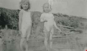
Still Creek near Nicholson's Farm
https://search.heritageburnaby.ca/link/archivedescription37033
- Repository
- City of Burnaby Archives
- Date
- 1918 (date of original), copied 1992
- Collection/Fonds
- Burnaby Historical Society fonds
- Description Level
- Item
- Physical Description
- 1 photograph : b&w ; 10.1 x 14.9 cm print
- Scope and Content
- Photograph of Roma Richards and Dorothy Boggust playing in Still Creek near the Nicholson's farm in the Broadview district.
- Repository
- City of Burnaby Archives
- Date
- 1918 (date of original), copied 1992
- Collection/Fonds
- Burnaby Historical Society fonds
- Subseries
- Burnaby Centennial Anthology subseries
- Physical Description
- 1 photograph : b&w ; 10.1 x 14.9 cm print
- Description Level
- Item
- Record No.
- 315-496
- Access Restriction
- No restrictions
- Reproduction Restriction
- No known restrictions
- Accession Number
- BHS1994-04
- Scope and Content
- Photograph of Roma Richards and Dorothy Boggust playing in Still Creek near the Nicholson's farm in the Broadview district.
- Subjects
- Geographic Features - Creeks
- Media Type
- Photograph
- Notes
- Title based on contents of photograph;
- Geographic Access
- Still Creek
- Historic Neighbourhood
- Broadview (Historic Neighbourhood)
- Planning Study Area
- West Central Valley Area
Images

![Subdivision plans in New Westminster District Group 1 – Burnaby
, [1890-1910] thumbnail](/media/hpo/_Data/_BVM_Cartographic_Material/1977/1977_0093_0014a_001.jpg?width=280)
Subdivision plans in New Westminster District Group 1 – Burnaby
https://search.heritageburnaby.ca/link/museumdescription6983
- Repository
- Burnaby Village Museum
- Date
- [1890-1910]
- Collection/Fonds
- Burnaby Village Museum Map collection
- Description Level
- File
- Physical Description
- 4 plans : blueprint ink on paper mounted on 2 sides of cardboard 76 x 102 cm
- Scope and Content
- Item consists of a large board of two New Westminster District Gp 1 - subdivision plans mounted on one side and two New Westminster District Gp 1 - subdivision plans mounted on the other side. Side A: 1. Blueprint "Plan of / Subdivision of Lot No. 69 / Group One / New Westminster District / Pro…
- Repository
- Burnaby Village Museum
- Collection/Fonds
- Burnaby Village Museum Map collection
- Description Level
- File
- Physical Description
- 4 plans : blueprint ink on paper mounted on 2 sides of cardboard 76 x 102 cm
- Material Details
- Scales [between 1:1584 and 1:3168]
- Index number on edge of board reads: "14"
- Scope and Content
- Item consists of a large board of two New Westminster District Gp 1 - subdivision plans mounted on one side and two New Westminster District Gp 1 - subdivision plans mounted on the other side. Side A: 1. Blueprint "Plan of / Subdivision of Lot No. 69 / Group One / New Westminster District / Property of Ernest Buse, Esq. / Scale 3 chs = 1 in. / Map No 290". Plan is signed by "Garden, Hermon and Burwell, Dom. Land Surveyor" (Geographic location: Burnaby) 2. Blueprint "Plan / of Subdivision / of Lots 1-19, 36-53 and 69-75 inclusive / in the Subdivision / of / Lot 30 / Group One / New Westminster District / Scale 2 chs = 1 in. Map No 631". Plan is signed by "Jno [sic] Strathern [sic] P.L.S." Names and Lot numbers are handwritten in red pencil in sections along Douglas Road and read: "20 - F / 21 - Fitherstruhaul [sic] / 22 - J.S. Craig / 23 - McGill & Dill / 24 / 25 / 26 / 27 / 28 - School / 29 - School / 30 - D. McDownall / 31 - W.J. Troloow [sic] / 32 - N.C. Nelson / 33 - _[sic] McGill / 34 - T.S.[sic] Craig / 35" (Geographic location: Burnaby) Side B: 1.Blueprint "Plan / of Subdivision / of Centre Portion / of Lot 28 / Group One / New Westminster District / Scale 200' = 1" / Map No 627". Plan is signed by "Jno Strathern / P.L.S." (Geographic location: Burnaby) 2. Blueprint "Plan / of Subdivision / of N.1/2 Lot 100 and S.1/2 Lot 101, / Group One / New Westminster District, BC / Scale 4 chs = 1 in." (Geographic location: Burnaby)
- Names
- Strathern, John
- Accession Code
- HV977.93.14
- Access Restriction
- No restrictions
- Reproduction Restriction
- No known restrictions
- Date
- [1890-1910]
- Media Type
- Cartographic Material
- Historic Neighbourhood
- Broadview (Historic Neighbourhood)
- East Burnaby (Historic Neighbourhood)
- Planning Study Area
- Cascade-Schou Area
- West Central Valley Area
- Second Street Area
- Lake City Area
- Scan Resolution
- 300
- Scale
- 72
- Notes
- Title based on contents of file
- Scale is measured in chains and feet. (One chain equals 792 inches)
- The term "Lot" can also refer to a "District Lot”
Images
![Subdivision plans in New Westminster District Group 1 – Burnaby
, [1890-1910] thumbnail](/media/hpo/_Data/_BVM_Cartographic_Material/1977/1977_0093_0014a_001.jpg)

![Willingdon on-ramp flooding, [2005] thumbnail](/media/hpo/_Data/_Archives_Images/_Unrestricted/535/535-1860-1.jpg?width=280)
Willingdon on-ramp flooding
https://search.heritageburnaby.ca/link/archivedescription96163
- Repository
- City of Burnaby Archives
- Date
- [2005]
- Collection/Fonds
- Burnaby NewsLeader photograph collection
- Description Level
- File
- Physical Description
- 2 photographs (tiff) : col.
- Scope and Content
- File contains photographs of flooding at the Willingdon on-ramp to Highway 1 in Burnaby after a significant rainstorm. Photographs depict a worker placing pylons to close the on-ramp and cars attempting to drive through deep puddles by the highway.
- Repository
- City of Burnaby Archives
- Date
- [2005]
- Collection/Fonds
- Burnaby NewsLeader photograph collection
- Physical Description
- 2 photographs (tiff) : col.
- Description Level
- File
- Record No.
- 535-1860
- Access Restriction
- No restrictions
- Reproduction Restriction
- No restrictions
- Accession Number
- 2018-12
- Scope and Content
- File contains photographs of flooding at the Willingdon on-ramp to Highway 1 in Burnaby after a significant rainstorm. Photographs depict a worker placing pylons to close the on-ramp and cars attempting to drive through deep puddles by the highway.
- Media Type
- Photograph
- Photographer
- Bartel, Mario
- Notes
- Title based on caption
- Collected by editorial for use in a January 2005 issue of the Burnaby NewsLeader
- Caption from metadata for 535-1860-1: "A worker for Mainroad Contracting closes the Willingdon on-ramp to Highway 1 because of flooding during Monday's torrential rainstorm."
- Caption from metadata for 535-1860-2: "After two weeks of snow and cold temperatures, Lower Mainland drivers find themselves in familiar territory, plowing through deep puddles on Willingdon, just north of Highway 1."
- Geographic Access
- Willingdon Avenue
- Planning Study Area
- West Central Valley Area
Images
![Willingdon on-ramp flooding, [2005] thumbnail](/media/hpo/_Data/_Archives_Images/_Unrestricted/535/535-1860-1.jpg)