Narrow Results By
Subject
- Agriculture - Farms 7
- Agriculture - Fruit and Berries 1
- Animals - Cows 3
- Animals - Dogs 3
- Animals - Horses 2
- Buildings - Agricultural - Barns 1
- Buildings - Commercial - General Stores 1
- Buildings - Heritage 3
- Buildings - Public - Post Offices 2
- Buildings - Residential 1
- Buildings - Residential - Cabins 1
- Buildings - Residential - Houses 22
Person / Organization
- Bird, Elizabeth "Bess" Cross Hart 1
- Bradbury, Dr. Bettina 1
- British Columbia Electric Railway 2
- Burnaby Central Secondary School 1
- Burnaby Lake Store 2
- Burnaby Village Museum 2
- Clayton, Edith 7
- Daniels, Mary Stone Sprott 1
- Douglas Road School 1
- Dowad, Kathleen "Kay" 1
- Dowad, Martha Elias Shaheen 1
- Dowad, Naomi "Mamie" David 1
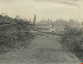
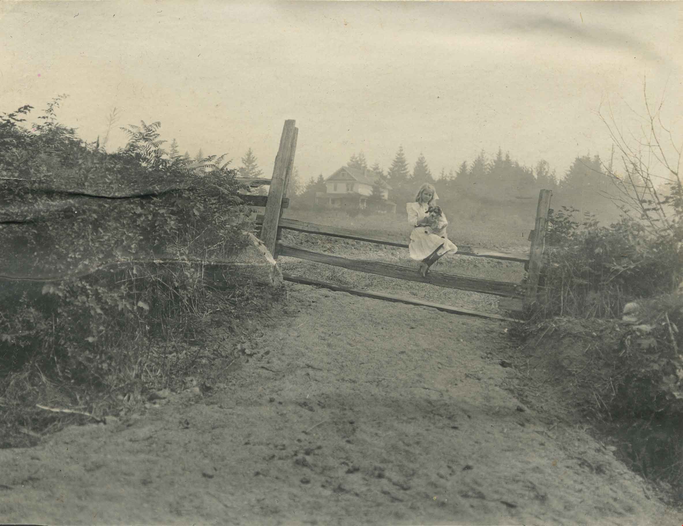
Kitty Hill sitting on a fence
https://search.heritageburnaby.ca/link/archivedescription39559
- Repository
- City of Burnaby Archives
- Date
- 1910
- Collection/Fonds
- Peers Family and Hill Family fonds
- Description Level
- Item
- Physical Description
- 1 photograph : b&w ; 7.8 x 10.1 cm on page 21.5 x 28 cm (pasted in album0
- Scope and Content
- Photograph of Kitty Hill sitting on a fence, holding a dog in her lap. The Hill family home, known as Broadview, is faintly visible in the background. It was located on Buckingham Avenue.
- Repository
- City of Burnaby Archives
- Date
- 1910
- Collection/Fonds
- Peers Family and Hill Family fonds
- Physical Description
- 1 photograph : b&w ; 7.8 x 10.1 cm on page 21.5 x 28 cm (pasted in album0
- Description Level
- Item
- Record No.
- 477-878
- Access Restriction
- No restrictions
- Reproduction Restriction
- No known restrictions
- Accession Number
- 2007-12
- Scope and Content
- Photograph of Kitty Hill sitting on a fence, holding a dog in her lap. The Hill family home, known as Broadview, is faintly visible in the background. It was located on Buckingham Avenue.
- Subjects
- Animals - Dogs
- Structures - Fences
- Media Type
- Photograph
- Notes
- Title based on contents of photograph
- Geographic Access
- Buckingham Avenue
- Street Address
- 5730 Buckingham Avenue
- Historic Neighbourhood
- Burnaby Lake (Historic Neighbourhood)
- Planning Study Area
- Morley-Buckingham Area
Images
![Kitty Hill sledding with pet dog, [1910] thumbnail](/media/hpo/_Data/_Archives_Images/_Unrestricted/477/477-066.jpg?width=280)
Kitty Hill sledding with pet dog
https://search.heritageburnaby.ca/link/archivedescription38747
- Repository
- City of Burnaby Archives
- Date
- [1910]
- Collection/Fonds
- Peers Family and Hill Family fonds
- Description Level
- Item
- Physical Description
- 1 photograph : b&w ; 6 x 11 cm on page 11.5 x 14 cm (pasted in album)
- Scope and Content
- Photographs of Kitty Hill on a sled, accompanied by a pet dog, most likely in front of the Hill family home, Broadview.
- Repository
- City of Burnaby Archives
- Date
- [1910]
- Collection/Fonds
- Peers Family and Hill Family fonds
- Physical Description
- 1 photograph : b&w ; 6 x 11 cm on page 11.5 x 14 cm (pasted in album)
- Description Level
- Item
- Record No.
- 477-066
- Access Restriction
- No restrictions
- Reproduction Restriction
- No known restrictions
- Accession Number
- 2007-12
- Scope and Content
- Photographs of Kitty Hill on a sled, accompanied by a pet dog, most likely in front of the Hill family home, Broadview.
- Media Type
- Photograph
- Notes
- Title based on contents of photograph
- Geographic Access
- Buckingham Avenue
- Street Address
- 5730 Buckingham Avenue
- Historic Neighbourhood
- Burnaby Lake (Historic Neighbourhood)
- Planning Study Area
- Morley-Buckingham Area
Images
![Kitty Hill sledding with pet dog, [1910] thumbnail](/media/hpo/_Data/_Archives_Images/_Unrestricted/477/477-066.jpg)
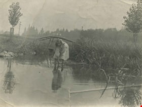
Kitty Hill wading in Deer Lake
https://search.heritageburnaby.ca/link/archivedescription39424
- Repository
- City of Burnaby Archives
- Date
- 1910
- Collection/Fonds
- Peers Family and Hill Family fonds
- Description Level
- Item
- Physical Description
- 1 photograph : b&w ; 7.2 x 10 cm
- Scope and Content
- Photograph of Kitty Hill wading in a small shallow creek. She has her feet submerged, and is dipping her hand in the water while looking up at the photographer. Just behind her is a small log bridge built over the creek, behind which can be seen a street lined with power poles, and a house in the …
- Repository
- City of Burnaby Archives
- Date
- 1910
- Collection/Fonds
- Peers Family and Hill Family fonds
- Physical Description
- 1 photograph : b&w ; 7.2 x 10 cm
- Description Level
- Item
- Record No.
- 477-743
- Access Restriction
- No restrictions
- Reproduction Restriction
- No known restrictions
- Accession Number
- 2007-12
- Scope and Content
- Photograph of Kitty Hill wading in a small shallow creek. She has her feet submerged, and is dipping her hand in the water while looking up at the photographer. Just behind her is a small log bridge built over the creek, behind which can be seen a street lined with power poles, and a house in the far distance, identified as "Broadview". An annotation on the back of the photo reads, "Kitty Hill 1910."
- Media Type
- Photograph
- Notes
- Title based on caption accompanying photograph
- Geographic Access
- Buckingham Avenue
- Deer Lake
- Street Address
- 5730 Buckingham Avenue
- Historic Neighbourhood
- Burnaby Lake (Historic Neighbourhood)
- Planning Study Area
- Morley-Buckingham Area
Images

![Kitty Hill with a parasol, [1910] thumbnail](/media/hpo/_Data/_Archives_Images/_Unrestricted/477/477-080.jpg?width=280)
Kitty Hill with a parasol
https://search.heritageburnaby.ca/link/archivedescription38761
- Repository
- City of Burnaby Archives
- Date
- [1910]
- Collection/Fonds
- Peers Family and Hill Family fonds
- Description Level
- Item
- Physical Description
- 1 photograph : sepia ; 4.5 x 5.5 cm on page 11.5 x 14 cm (pasted in album)
- Scope and Content
- Photograph of Kitty Hill sitting in a field holding a parasol. The photograph was likely taken on the Hill family property known as Broadview on Buckingham Avenue.
- Repository
- City of Burnaby Archives
- Date
- [1910]
- Collection/Fonds
- Peers Family and Hill Family fonds
- Physical Description
- 1 photograph : sepia ; 4.5 x 5.5 cm on page 11.5 x 14 cm (pasted in album)
- Description Level
- Item
- Record No.
- 477-080
- Access Restriction
- No restrictions
- Reproduction Restriction
- No known restrictions
- Accession Number
- 2007-12
- Scope and Content
- Photograph of Kitty Hill sitting in a field holding a parasol. The photograph was likely taken on the Hill family property known as Broadview on Buckingham Avenue.
- Media Type
- Photograph
- Notes
- Title based on contents of photograph
- Geographic Access
- Buckingham Avenue
- Street Address
- 5730 Buckingham Avenue
- Historic Neighbourhood
- Burnaby Lake (Historic Neighbourhood)
- Planning Study Area
- Morley-Buckingham Area
Images
![Kitty Hill with a parasol, [1910] thumbnail](/media/hpo/_Data/_Archives_Images/_Unrestricted/477/477-080.jpg)
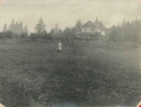
Kitty in front of Broadview
https://search.heritageburnaby.ca/link/archivedescription39556
- Repository
- City of Burnaby Archives
- Date
- 1910
- Collection/Fonds
- Peers Family and Hill Family fonds
- Description Level
- Item
- Physical Description
- 1 photograph : b&w ; 7.6 x 10.2 cm on page 21.5 x 28 cm (pasted in album)
- Scope and Content
- Photograph of Kitty Hill standing in the field in front of her family home, known as Broadview on Buckingham Avenue. This was the second Hill family home in the Burnaby Lake area and it was built around 1907. The first Hill home, Brookfield was on Deer Lake Avenue.
- Repository
- City of Burnaby Archives
- Date
- 1910
- Collection/Fonds
- Peers Family and Hill Family fonds
- Physical Description
- 1 photograph : b&w ; 7.6 x 10.2 cm on page 21.5 x 28 cm (pasted in album)
- Description Level
- Item
- Record No.
- 477-875
- Access Restriction
- No restrictions
- Reproduction Restriction
- No known restrictions
- Accession Number
- 2007-12
- Scope and Content
- Photograph of Kitty Hill standing in the field in front of her family home, known as Broadview on Buckingham Avenue. This was the second Hill family home in the Burnaby Lake area and it was built around 1907. The first Hill home, Brookfield was on Deer Lake Avenue.
- Media Type
- Photograph
- Notes
- Title based on contents of photograph
- Geographic Access
- Buckingham Avenue
- Street Address
- 5730 Buckingham Avenue
- Historic Neighbourhood
- Burnaby Lake (Historic Neighbourhood)
- Planning Study Area
- Morley-Buckingham Area
Images
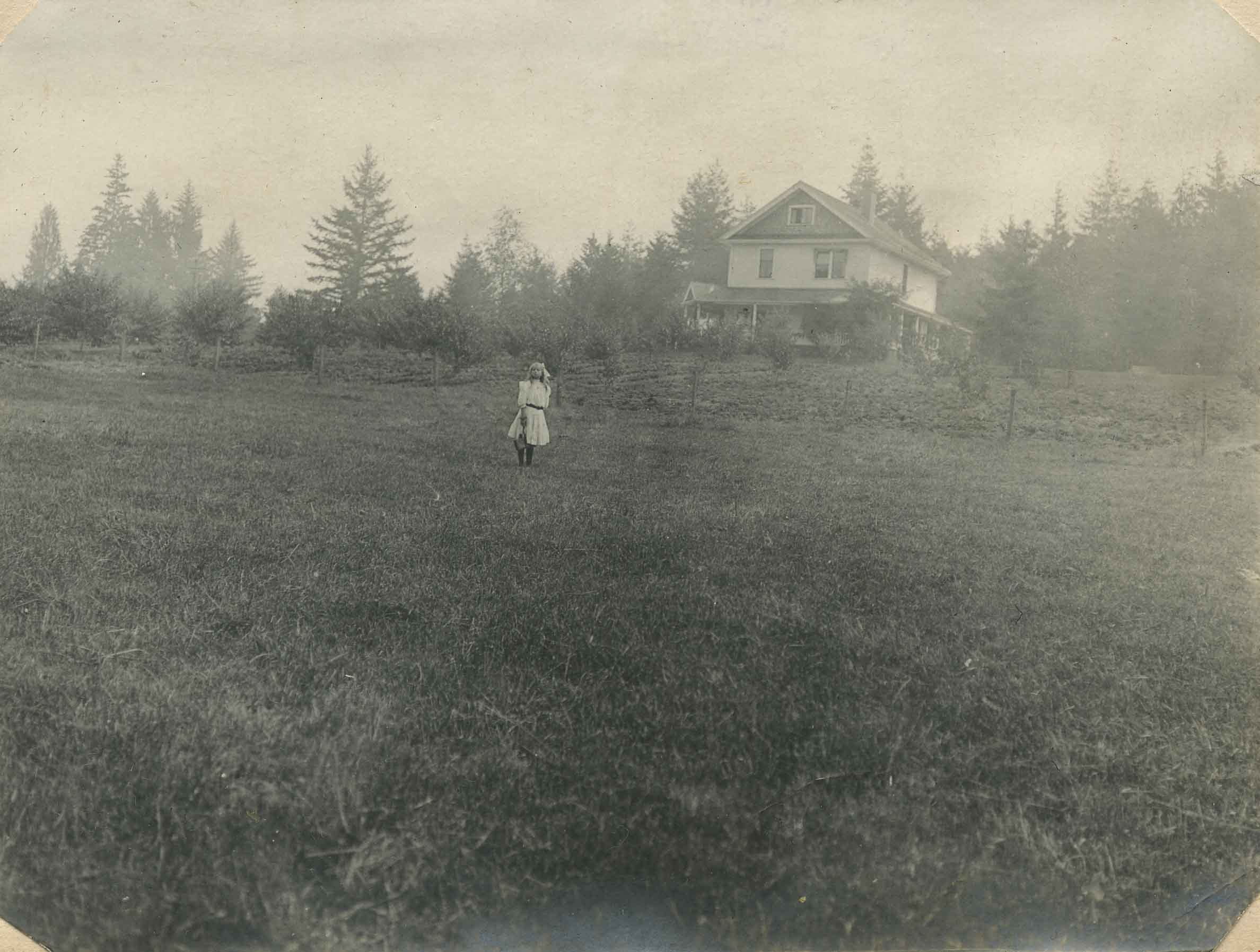
Kitty on the lawn of Broadview
https://search.heritageburnaby.ca/link/archivedescription39552
- Repository
- City of Burnaby Archives
- Date
- 1910
- Collection/Fonds
- Peers Family and Hill Family fonds
- Description Level
- Item
- Physical Description
- 1 photograph : b&w ; 8 x 10.5 cm on page 21.5 x 28 cm (pasted in album)
- Scope and Content
- Photograph of the home of Claude Hill, known as Broadview, on Buckingham Avenue. Broadview was the second Hill home in the Burnaby Lake area, the first being "Brookfield" on Deer Lake Avenue In front of the house is Claude's daughter Kitty, with a dog.
- Repository
- City of Burnaby Archives
- Date
- 1910
- Collection/Fonds
- Peers Family and Hill Family fonds
- Physical Description
- 1 photograph : b&w ; 8 x 10.5 cm on page 21.5 x 28 cm (pasted in album)
- Description Level
- Item
- Record No.
- 477-871
- Access Restriction
- No restrictions
- Reproduction Restriction
- No known restrictions
- Accession Number
- 2007-12
- Scope and Content
- Photograph of the home of Claude Hill, known as Broadview, on Buckingham Avenue. Broadview was the second Hill home in the Burnaby Lake area, the first being "Brookfield" on Deer Lake Avenue In front of the house is Claude's daughter Kitty, with a dog.
- Media Type
- Photograph
- Notes
- Title based on contents of photograph
- Geographic Access
- Buckingham Avenue
- Street Address
- 5730 Buckingham Avenue
- Historic Neighbourhood
- Burnaby Lake (Historic Neighbourhood)
- Planning Study Area
- Morley-Buckingham Area
Images

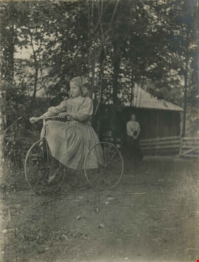
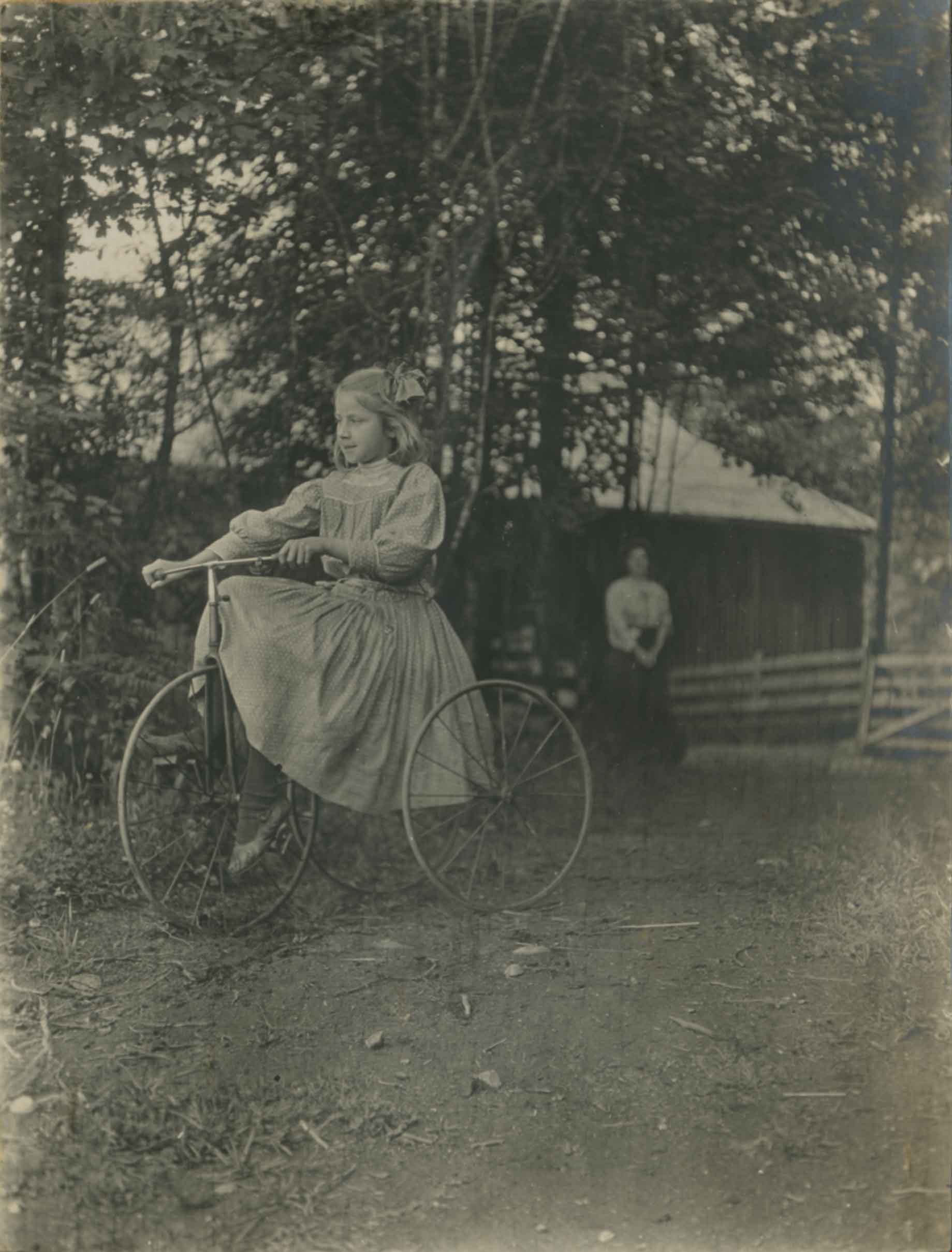
Kitty Riding a Bike
https://search.heritageburnaby.ca/link/archivedescription39438
- Repository
- City of Burnaby Archives
- Date
- 1910
- Collection/Fonds
- Peers Family and Hill Family fonds
- Description Level
- Item
- Physical Description
- 1 photograph : b&w ; 8 x 10.5 cm on page 21.5 x 28 cm (pasted in album)
- Scope and Content
- Photograph of Kitty Hill riding a bicycle. A woman, most likely her mother Annie, can be seen in the background.
- Repository
- City of Burnaby Archives
- Date
- 1910
- Collection/Fonds
- Peers Family and Hill Family fonds
- Physical Description
- 1 photograph : b&w ; 8 x 10.5 cm on page 21.5 x 28 cm (pasted in album)
- Description Level
- Item
- Record No.
- 477-757
- Access Restriction
- No restrictions
- Reproduction Restriction
- No known restrictions
- Accession Number
- 2007-12
- Scope and Content
- Photograph of Kitty Hill riding a bicycle. A woman, most likely her mother Annie, can be seen in the background.
- Subjects
- Transportation - Bicycles
- Media Type
- Photograph
- Notes
- Title based on contents of photograph
- Historic Neighbourhood
- Burnaby Lake (Historic Neighbourhood)
- Planning Study Area
- Morley-Buckingham Area
Images
![L. Claude Hill's Broadview, [1910] thumbnail](/media/hpo/_Data/_Archives_Images/_Unrestricted/477/477-057.jpg?width=280)
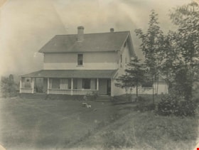
L. Claude Hill's Broadview
https://search.heritageburnaby.ca/link/archivedescription38738
- Repository
- City of Burnaby Archives
- Date
- [1910]
- Collection/Fonds
- Peers Family and Hill Family fonds
- Description Level
- Item
- Physical Description
- 1 photograph : sepia ; 7 x 11.5 cm on page 11.5 x 14 cm (pasted in album)
- Scope and Content
- Photograph of the house called "Broadview" which was built by Claude Hill in the Burnaby Lake district ca. 1907.
- Repository
- City of Burnaby Archives
- Date
- [1910]
- Collection/Fonds
- Peers Family and Hill Family fonds
- Physical Description
- 1 photograph : sepia ; 7 x 11.5 cm on page 11.5 x 14 cm (pasted in album)
- Description Level
- Item
- Record No.
- 477-057
- Access Restriction
- No restrictions
- Reproduction Restriction
- No known restrictions
- Accession Number
- 2007-12
- Scope and Content
- Photograph of the house called "Broadview" which was built by Claude Hill in the Burnaby Lake district ca. 1907.
- Subjects
- Buildings - Residential - Houses
- Media Type
- Photograph
- Notes
- Title based on contents of photograph
- Geographic Access
- Buckingham Avenue
- Street Address
- 5730 Buckingham Avenue
- Historic Neighbourhood
- Burnaby Lake (Historic Neighbourhood)
- Planning Study Area
- Morley-Buckingham Area
Images
![L. Claude Hill's Broadview, [1910] thumbnail](/media/hpo/_Data/_Archives_Images/_Unrestricted/477/477-057.jpg)
![Maude Woodward, [1910] thumbnail](/media/hpo/_Data/_Archives_Images/_Unrestricted/477/477-192.jpg?width=280)
Maude Woodward
https://search.heritageburnaby.ca/link/archivedescription38873
- Repository
- City of Burnaby Archives
- Date
- [1910]
- Collection/Fonds
- Peers Family and Hill Family fonds
- Description Level
- Item
- Physical Description
- 1 photograph : sepia ; 10.3 x 6 cm on page 14 x 17.5 cm (pasted in album)
- Scope and Content
- Photograph of Maude Woodward digging in the garden (most likely at the Burnaby Lake home of her and her sister Harriet Woodward). A bucket and shovel are on the ground next to her.
- Repository
- City of Burnaby Archives
- Date
- [1910]
- Collection/Fonds
- Peers Family and Hill Family fonds
- Physical Description
- 1 photograph : sepia ; 10.3 x 6 cm on page 14 x 17.5 cm (pasted in album)
- Description Level
- Item
- Record No.
- 477-192
- Access Restriction
- No restrictions
- Reproduction Restriction
- No known restrictions
- Accession Number
- 2007-12
- Scope and Content
- Photograph of Maude Woodward digging in the garden (most likely at the Burnaby Lake home of her and her sister Harriet Woodward). A bucket and shovel are on the ground next to her.
- Subjects
- Geographic Features - Gardens
- Names
- Woodward, Maude
- Media Type
- Photograph
- Notes
- Title based on contents of photograph
- Geographic Access
- Sperling Avenue
- Street Address
- 5141 Sperling Avenue
- Historic Neighbourhood
- Burnaby Lake (Historic Neighbourhood)
- Planning Study Area
- Morley-Buckingham Area
Images
![Maude Woodward, [1910] thumbnail](/media/hpo/_Data/_Archives_Images/_Unrestricted/477/477-192.jpg)
![McKenzie family, [191-?] (date of original), copied 1992 thumbnail](/media/hpo/_Data/_Archives_Images/_Unrestricted/315/315-500.jpg?width=280)
McKenzie family
https://search.heritageburnaby.ca/link/archivedescription37037
- Repository
- City of Burnaby Archives
- Date
- [191-?] (date of original), copied 1992
- Collection/Fonds
- Burnaby Historical Society fonds
- Description Level
- Item
- Physical Description
- 1 photograph : b&w ; 8.0 x 12.7 cm print
- Scope and Content
- Photograph of the McKenzie family on the steps of their house on Laurier Street (now Halligan Street).
- Repository
- City of Burnaby Archives
- Date
- [191-?] (date of original), copied 1992
- Collection/Fonds
- Burnaby Historical Society fonds
- Subseries
- Burnaby Centennial Anthology subseries
- Physical Description
- 1 photograph : b&w ; 8.0 x 12.7 cm print
- Description Level
- Item
- Record No.
- 315-500
- Access Restriction
- No restrictions
- Reproduction Restriction
- No restrictions
- Accession Number
- BHS1994-04
- Scope and Content
- Photograph of the McKenzie family on the steps of their house on Laurier Street (now Halligan Street).
- Media Type
- Photograph
- Notes
- Title based on contents of photograph
- Geographic Access
- Halligan Street
- Historic Neighbourhood
- Edmonds (Historic Neighbourhood)
- Planning Study Area
- Morley-Buckingham Area
Images
![McKenzie family, [191-?] (date of original), copied 1992 thumbnail](/media/hpo/_Data/_Archives_Images/_Unrestricted/315/315-500.jpg)

McKenzie family home
https://search.heritageburnaby.ca/link/archivedescription37034
- Repository
- City of Burnaby Archives
- Date
- 1912 (date of original), copied 1992
- Collection/Fonds
- Burnaby Historical Society fonds
- Description Level
- Item
- Physical Description
- 1 photograph : b&w ; 7.6 x 12.6 cm print
- Scope and Content
- Photograph of the McKenzie family home and farm on Laurier Street (now Halligan Street).
- Repository
- City of Burnaby Archives
- Date
- 1912 (date of original), copied 1992
- Collection/Fonds
- Burnaby Historical Society fonds
- Subseries
- Burnaby Centennial Anthology subseries
- Physical Description
- 1 photograph : b&w ; 7.6 x 12.6 cm print
- Description Level
- Item
- Record No.
- 315-497
- Access Restriction
- No restrictions
- Reproduction Restriction
- No known restrictions
- Accession Number
- BHS1994-04
- Scope and Content
- Photograph of the McKenzie family home and farm on Laurier Street (now Halligan Street).
- Media Type
- Photograph
- Notes
- Title based on contents of photograph
- Geographic Access
- Halligan Street
- Historic Neighbourhood
- Edmonds (Historic Neighbourhood)
- Planning Study Area
- Morley-Buckingham Area
Images


McKenzie family home
https://search.heritageburnaby.ca/link/archivedescription37039
- Repository
- City of Burnaby Archives
- Date
- 1912 (date of original), copied 1992
- Collection/Fonds
- Burnaby Historical Society fonds
- Description Level
- Item
- Physical Description
- 1 photograph : b&w ; 8.1 x 12.1 cm print
- Scope and Content
- Photograph of the McKenzie family home and farm on Laurier Street (now Halligan Street) with added rooms at the back and a strawberry patch in front.
- Repository
- City of Burnaby Archives
- Date
- 1912 (date of original), copied 1992
- Collection/Fonds
- Burnaby Historical Society fonds
- Subseries
- Burnaby Centennial Anthology subseries
- Physical Description
- 1 photograph : b&w ; 8.1 x 12.1 cm print
- Description Level
- Item
- Record No.
- 315-502
- Access Restriction
- No restrictions
- Reproduction Restriction
- No known restrictions
- Accession Number
- BHS1994-04
- Scope and Content
- Photograph of the McKenzie family home and farm on Laurier Street (now Halligan Street) with added rooms at the back and a strawberry patch in front.
- Media Type
- Photograph
- Notes
- Title based on contents of photograph
- Geographic Access
- Halligan Street
- Historic Neighbourhood
- Edmonds (Historic Neighbourhood)
- Planning Study Area
- Morley-Buckingham Area
Images


McKenzie family home and farm
https://search.heritageburnaby.ca/link/archivedescription37035
- Repository
- City of Burnaby Archives
- Date
- 1912 (date of original), copied 1992
- Collection/Fonds
- Burnaby Historical Society fonds
- Description Level
- Item
- Physical Description
- 1 photograph : b&w ; 8.6 x 12.7 cm print
- Scope and Content
- Photograph of the McKenzie family home and farm on Laurier Street (now Halligan Street). Cows can be seen in the background and a girl in the foreground.
- Repository
- City of Burnaby Archives
- Date
- 1912 (date of original), copied 1992
- Collection/Fonds
- Burnaby Historical Society fonds
- Subseries
- Burnaby Centennial Anthology subseries
- Physical Description
- 1 photograph : b&w ; 8.6 x 12.7 cm print
- Description Level
- Item
- Record No.
- 315-498
- Access Restriction
- No restrictions
- Reproduction Restriction
- No known restrictions
- Accession Number
- BHS1994-04
- Scope and Content
- Photograph of the McKenzie family home and farm on Laurier Street (now Halligan Street). Cows can be seen in the background and a girl in the foreground.
- Media Type
- Photograph
- Notes
- Title based on contents of photograph
- Geographic Access
- Halligan Street
- Historic Neighbourhood
- Edmonds (Historic Neighbourhood)
- Planning Study Area
- Morley-Buckingham Area
Images


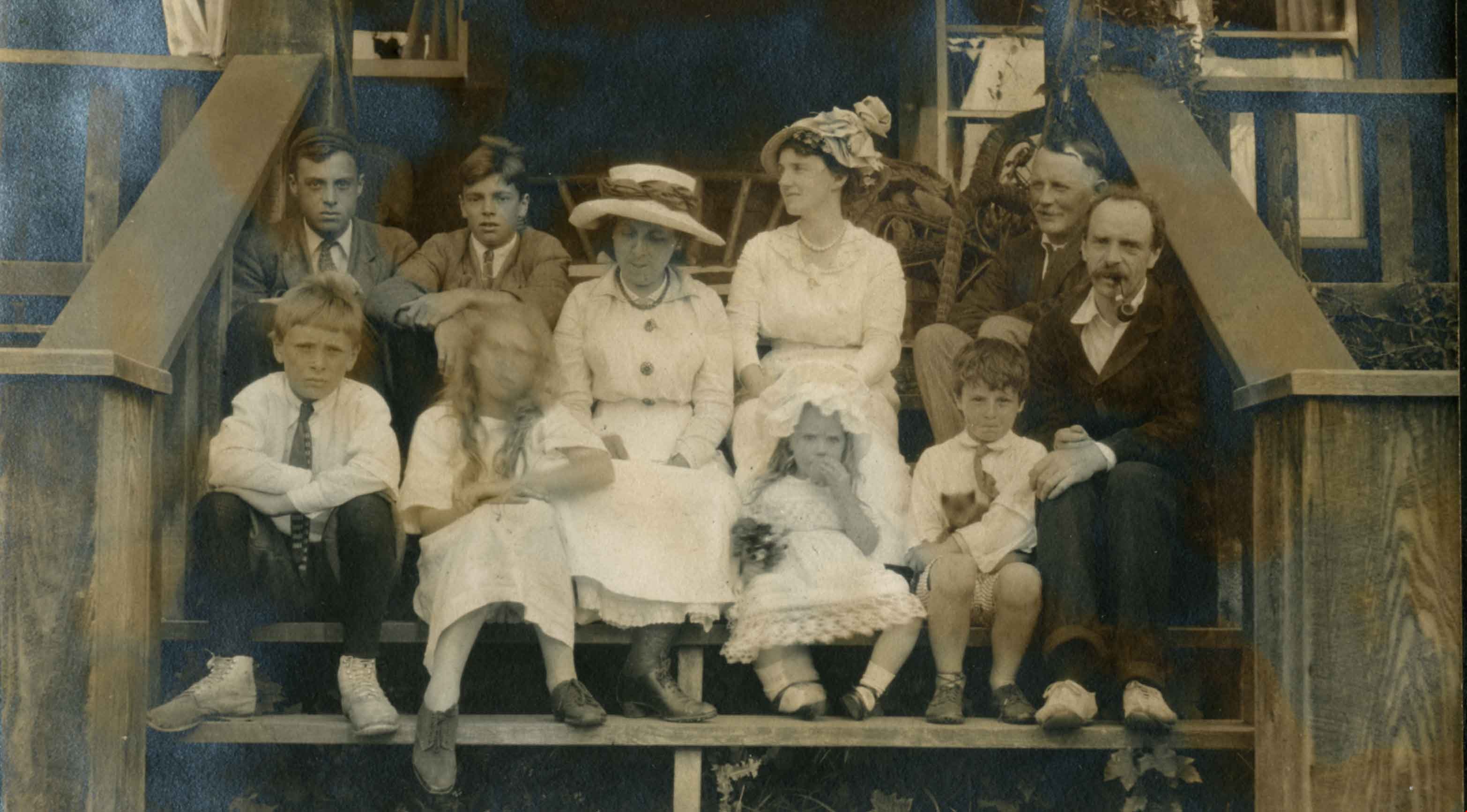
Peers Family
https://search.heritageburnaby.ca/link/archivedescription66266
- Repository
- City of Burnaby Archives
- Date
- 1913
- Collection/Fonds
- Peers Family and Hill Family fonds
- Description Level
- Item
- Physical Description
- 1 photograph
- Scope and Content
- Photograph shows the Peers family and friends seated on the steps in front of Greyfriars, their family home. In the front row, left to right are: Geoffrey Peers, Mary Elizabeth Peers, Annie Elizabeth Peers (at centre), Judy ?, Richard Peers, Francis Peers (with pipe). Back row, left to right: Art…
- Repository
- City of Burnaby Archives
- Date
- 1913
- Collection/Fonds
- Peers Family and Hill Family fonds
- Physical Description
- 1 photograph
- Description Level
- Item
- Record No.
- 477-978
- Access Restriction
- No restrictions
- Reproduction Restriction
- No known restrictions
- Accession Number
- 2007-12
- Scope and Content
- Photograph shows the Peers family and friends seated on the steps in front of Greyfriars, their family home. In the front row, left to right are: Geoffrey Peers, Mary Elizabeth Peers, Annie Elizabeth Peers (at centre), Judy ?, Richard Peers, Francis Peers (with pipe). Back row, left to right: Arthur Peers, William John Peers, Mrs. W. and Mr. L. Annie Elizabeth and Francis were the parents to Arthur (aka Mike), William John (aka Bob), Geoffrey, Mary Elizabeth (aka Betty) and Richard (aka Dick).
- Names
- Peers, Arthur Francis "Mike"
- Peers, Francis J.
- Peers, Geoffrey Hugh
- Peers, Richard Dominic "Dick"
- Peers, William John "Bob"
- Peers, Annie Elizabeth Frisby
- Freebairn-Smith, Mary Elizabeth "Betty" Peers
- Media Type
- Photograph
- Notes
- Title based on contents of photograph
- Geographic Access
- Rugby Street
- Street Address
- 5289 Rugby Avenue
- Historic Neighbourhood
- Burnaby Lake (Historic Neighbourhood)
- Planning Study Area
- Morley-Buckingham Area
Images
![Peers family house, [between 1914 and 1917] (date of original), copied 1985 thumbnail](/media/hpo/_Data/_Archives_Images/_Unrestricted/126/141-006.jpg?width=280)
Peers family house
https://search.heritageburnaby.ca/link/archivedescription34836
- Repository
- City of Burnaby Archives
- Date
- [between 1914 and 1917] (date of original), copied 1985
- Collection/Fonds
- Burnaby Historical Society fonds
- Description Level
- Item
- Physical Description
- 1 photograph : b&w ; 8.8 x 12.5 cm print
- Scope and Content
- Photograph of three young people seated outside of the Peers family house, Greyfriars, near Sperling Avenue. The man is in uniform. Identified by Edith Hopkins, left to right: Florence Hart, Bob Peers, and Kitty Peers (nee Hill).
- Repository
- City of Burnaby Archives
- Date
- [between 1914 and 1917] (date of original), copied 1985
- Collection/Fonds
- Burnaby Historical Society fonds
- Subseries
- Every-Clayton family subseries
- Physical Description
- 1 photograph : b&w ; 8.8 x 12.5 cm print
- Description Level
- Item
- Record No.
- 141-006
- Access Restriction
- No restrictions
- Reproduction Restriction
- No known restrictions
- Accession Number
- BHS1985-11
- Scope and Content
- Photograph of three young people seated outside of the Peers family house, Greyfriars, near Sperling Avenue. The man is in uniform. Identified by Edith Hopkins, left to right: Florence Hart, Bob Peers, and Kitty Peers (nee Hill).
- Subjects
- Clothing - Military Uniforms
- Media Type
- Photograph
- Notes
- Title based on contents of photograph
- Geographic Access
- Rugby Street
- Street Address
- 5289 Rugby Avenue
- Historic Neighbourhood
- Burnaby Lake (Historic Neighbourhood)
- Planning Study Area
- Morley-Buckingham Area
Images
![Peers family house, [between 1914 and 1917] (date of original), copied 1985 thumbnail](/media/hpo/_Data/_Archives_Images/_Unrestricted/126/141-006.jpg)

Shearer Shack
https://search.heritageburnaby.ca/link/archivedescription70546
- Repository
- City of Burnaby Archives
- Date
- 1911
- Collection/Fonds
- Shearer Family fonds
- Description Level
- Item
- Physical Description
- 1 photograph (jpeg)
- Scope and Content
- Photograph of Jim Shearer, his wife Katherine (Dormer), and their daughter, Katie, posed in front of the temporary shelter erected at 5573 Buckingham Avenue during the construction of their home on that site, which was commissioned by Katherine's father, Francis Joseph Dormer. The image was taken s…
- Repository
- City of Burnaby Archives
- Date
- 1911
- Collection/Fonds
- Shearer Family fonds
- Physical Description
- 1 photograph (jpeg)
- Description Level
- Item
- Record No.
- 530-001
- Access Restriction
- No restrictions
- Reproduction Restriction
- No known restrictions
- Accession Number
- 2012-05
- Scope and Content
- Photograph of Jim Shearer, his wife Katherine (Dormer), and their daughter, Katie, posed in front of the temporary shelter erected at 5573 Buckingham Avenue during the construction of their home on that site, which was commissioned by Katherine's father, Francis Joseph Dormer. The image was taken shortly before their son James Francis was born.
- Media Type
- Photograph
- Photographer
- Shearer, Tony
- Geographic Access
- Buckingham Avenue
- Street Address
- 5573 Buckingham Avenue
- Historic Neighbourhood
- Burnaby Lake (Historic Neighbourhood)
- Planning Study Area
- Morley-Buckingham Area
Images

![Sitting on the steps of Greyfriars, [1910] thumbnail](/media/hpo/_Data/_Archives_Images/_Unrestricted/477/477-974.jpg?width=280)
Sitting on the steps of Greyfriars
https://search.heritageburnaby.ca/link/archivedescription66262
- Repository
- City of Burnaby Archives
- Date
- [1910]
- Collection/Fonds
- Peers Family and Hill Family fonds
- Description Level
- Item
- Physical Description
- 1 photograph
- Scope and Content
- Photograph shows one man and four children sitting of the steps of what appears to be "Greyfriars," the home of Francis Peers. The man has been identified as Francis. The picture is badly faded.
- Repository
- City of Burnaby Archives
- Date
- [1910]
- Collection/Fonds
- Peers Family and Hill Family fonds
- Physical Description
- 1 photograph
- Description Level
- Item
- Record No.
- 477-974
- Access Restriction
- No restrictions
- Reproduction Restriction
- No known restrictions
- Accession Number
- 2007-12
- Scope and Content
- Photograph shows one man and four children sitting of the steps of what appears to be "Greyfriars," the home of Francis Peers. The man has been identified as Francis. The picture is badly faded.
- Names
- Peers, Francis J.
- Media Type
- Photograph
- Notes
- Title based on contents of photograph
- Geographic Access
- Rugby Street
- Street Address
- 5289 Rugby Avenue
- Historic Neighbourhood
- Burnaby Lake (Historic Neighbourhood)
- Planning Study Area
- Morley-Buckingham Area
Images
![Sitting on the steps of Greyfriars, [1910] thumbnail](/media/hpo/_Data/_Archives_Images/_Unrestricted/477/477-974.jpg)
![The Spinney, [1915] thumbnail](/media/hpo/_Data/_Archives_Images/_Unrestricted/477/477-652.jpg?width=280)
The Spinney
https://search.heritageburnaby.ca/link/archivedescription39333
- Repository
- City of Burnaby Archives
- Date
- [1915]
- Collection/Fonds
- Peers Family and Hill Family fonds
- Description Level
- Item
- Physical Description
- 1 photograph : b&w ; 6 x 10.2 cm on page 24.5 x 32.5 cm (pasted in album)
- Scope and Content
- Photograph looking north towards the Pole Line Road (Sperling Avenue) from the farm of Claude Hill. The photograph has been captioned "The Spinney."
- Repository
- City of Burnaby Archives
- Date
- [1915]
- Collection/Fonds
- Peers Family and Hill Family fonds
- Physical Description
- 1 photograph : b&w ; 6 x 10.2 cm on page 24.5 x 32.5 cm (pasted in album)
- Description Level
- Item
- Record No.
- 477-652
- Access Restriction
- No restrictions
- Reproduction Restriction
- No known restrictions
- Accession Number
- 2007-12
- Scope and Content
- Photograph looking north towards the Pole Line Road (Sperling Avenue) from the farm of Claude Hill. The photograph has been captioned "The Spinney."
- Subjects
- Agriculture - Farms
- Media Type
- Photograph
- Notes
- Title based on caption accompanying photograph
- Geographic Access
- Sperling Avenue
- Historic Neighbourhood
- Burnaby Lake (Historic Neighbourhood)
- Planning Study Area
- Morley-Buckingham Area
Images
![The Spinney, [1915] thumbnail](/media/hpo/_Data/_Archives_Images/_Unrestricted/477/477-652.jpg)
![Survey and Subdivision plans in New Westminster District Group 1 and Group 2 – Vancouver, ʷməθkʷəy̓əm (Musqueam) Indian Reserve, Burnaby, Surrey
, [1910-1911] thumbnail](/media/hpo/_Data/_BVM_Cartographic_Material/1977/1977_0093_0017_001.jpg?width=280)
Survey and Subdivision plans in New Westminster District Group 1 and Group 2 – Vancouver, ʷməθkʷəy̓əm (Musqueam) Indian Reserve, Burnaby, Surrey
https://search.heritageburnaby.ca/link/museumdescription6986
- Repository
- Burnaby Village Museum
- Date
- [1910-1911]
- Collection/Fonds
- Burnaby Village Museum Map collection
- Description Level
- File
- Physical Description
- 9 plans : 4 plans : blueprint ink on paper + 4 plans : black ink on paper + 1 plan : graphite on paper mounted on 2 sides of cardboard 76 x 102 cm
- Scope and Content
- File consists of a large board of three survey plans in New Westminster District Group 1 mounted on one side and six survey and subdivision plans of District Lot 85, New Westminster District Group 1 mounted on the other side. Side A: 1. Plan : blueprint on paper ; 30.5 x 80 cm. Title reads: "Fras…
- Repository
- Burnaby Village Museum
- Collection/Fonds
- Burnaby Village Museum Map collection
- Description Level
- File
- Physical Description
- 9 plans : 4 plans : blueprint ink on paper + 4 plans : black ink on paper + 1 plan : graphite on paper mounted on 2 sides of cardboard 76 x 102 cm
- Material Details
- Scales vary (One chain equals 792 inches)
- Indexed number on tape on edge of board reads "17"
- Scope and Content
- File consists of a large board of three survey plans in New Westminster District Group 1 mounted on one side and six survey and subdivision plans of District Lot 85, New Westminster District Group 1 mounted on the other side. Side A: 1. Plan : blueprint on paper ; 30.5 x 80 cm. Title reads: "Fraser River Bridge / Plan of South Approach". Plan covers area of land north of the Fraser River and Great Northern Railway with approach for a bridge running through the "ʷməθkʷəy̓əm (Musqueam) Indian Reserve" (ʷməθkʷəy̓əm (Musqueam) First Nation) and lots marked as Dominion Government and the east half of Lot 2 identified as "C. F. Brown" "Plan 851". Plan is identified as "Plan 851 / traced / Mar. 17, 1911". (Geographic location in Vancouver) Scale: 100 feet = 1 inch, Signed by Albert J. Hill / P.L.S." 2. Plan : blueprint on paper ; 36.5 x 35 cm (no title). Includes three plans of lots on the east and west sides of North Road. Note on bottom of blueprint reads: "I.E.B. McKay Surveyor General - hereby certify / that this is a correct tracing from the field / notes of the Royal Engineers on file in the / Lands Department / E.B. McKay (signature) / Surveyor General / Victoria B.C. April 11th 1911" . Plan in top left titled "Page 11 / Vol. 1. / R.E. Notes" covers District Lots east of North Road including Lot 5, Lot 7, Lot 41, Lot 9 and Lot 107 in Coquitlam. Plan in top right corner titled "Page 17 / Vol. 1. / R.E. Notes" covers District Lots east of North Road including Lot 104, Lot 54, Lot 105, Lot 55, Lot 106, Lot 9 and Lot 107 in Coquitlam and Port Moody. Plan in lower left corner titled "Page 15 / Vol. 1 / R.E. Notes" covers District Lots west of North Road including Lot 147, Lot 148, Lot 100, Lot 15 in Burnaby. 3. Plan : blue print on paper ; 29.5 x 41.5 cm. (no formal title). Plan of the North 1/2 of Section 18. Plan covers area in the "North 1/2 of Sec.18 B.5 N RGE 1 W" and "Sec. 18 B.5 N. RGE 1 W" bordered by Section 7, Section 13, Section 17 and Section 19. Bon Accord Road runs through Sec. 18. The plan is signed by surveryor "I.H. Neville Smith... C.E.B.C.L.S. / Mar. 26th 1910" and signed by "Ludwig Pillath". (Geographic location: Surrey) Side B: 1. Plan : blueprint on paper ; 43.5 x 49.5 cm. Title reads: "Plan / of Subdivision / of a Portion / of / Lot 85 / Group One / New Westminster District. Plan covers portion of land east of Deer Lake and Pole Line Road (Sperling Avenue) and south of Hastings Road in District Lot 85 in Burnaby with section 4 and a portion of section 2 coloured in red. Plan is signed by "Albert J. Hill, B.C.L.S." Plan is initialed by: "RB" [sic] (in blue pencil crayon) Scale: 4 chains = 1 inch 2. Plaln : black black ink on linen ; 39 x 37 cm. Title reads: "L.C. Hill's Property, / Burnaby". Plan covers a triangular portion of land east of Pole Line Road (Sperling Avenue) and south of Hastings Road in District Lot 85 in Burnaby. Plan is intitaled by "RB" [sic] (in blue pencil crayon). Scale: 3 chains = 1 mile 3. Plan : graphite on paper ; 23 x 17 cm. Title reads: "Portion of Lot 85 / Gr.1". Plan covers portion of land north east of Deer Lake and west of Pole Line Road (now Sperling Avenue) in District Lot 85 in Burnaby. Plan is stamped in red ink: "Albert J. Hill, Civil Engineer". Plan is initialed by: "RB" [sic] (in blue pencil crayon). Scale: 1 chain = 1 inch 4. Plan : black ink on linen ; 16 x 19 cm. Title reads: "Lot 85". Plan covers the intersection of Pole Line Road (Sperling Avenue) and Hastings Road at the north west section of District Lot 79 and District Lot 85 in Burnaby. Plan is stamped: "A.J. Hill, Civil Engineer" with identitifed in blue pencil crayon. 5. Plan : black ink on paper ; 28.5 x 37 cm. (no formal title) Plan covers an area of land, west of Pole Line Road (Sperling Avenue) and south of Deer Lake in District Lot 85 in Burnaby. Plan is initialed by: "RB" [sic] (in blue pencil crayon) 6. Plan : black ink on paper ; 21 x 34 cm (no formal title). Plan covers an area of land, west of Pole Line Road (Sperling Avenue) and south of Deer Lake in District Lot 85 in Burnaby. Plan is initialed by: "RB" [sic] (in blue pencil crayon)
- Accession Code
- HV977.93.17
- Access Restriction
- No restrictions
- Reproduction Restriction
- No known restrictions
- Date
- [1910-1911]
- Media Type
- Cartographic Material
- Historic Neighbourhood
- Burnaby Lake (Historic Neighbourhood)
- Burquitlam (Historic Neighbourhood)
- Planning Study Area
- Morley-Buckingham Area
- Douglas-Gilpin Area
- Scan Resolution
- 600
- Scan Date
- 2023-06-26
- Notes
- Title based on contents of file
- Scale is measured in chains and feet. (One chain equals 792 inches).
- The term "Lot" also refers to a "District Lot”
- Some plans are stamped: "Albert J. Hill, Civil Engineer / and / Provincial Land Surveyor, / New Westminster, / B.C." and intialed: "RB" [sic]
Zoomable Images
![Survey and Subdivision plans in New Westminster District Group 1 and Group 2 – Vancouver, ʷməθkʷəy̓əm (Musqueam) Indian Reserve, Burnaby, Surrey
, [1910-1911] thumbnail](/media/hpo/_Data/_BVM_Cartographic_Material/1977/1977_0093_0017_003_seadragon/1977_0093_0017_003.jpg?w=280)
Survey and Subdivision plans in New Westminster District Group 1 and Group 2 – Vancouver, ʷməθkʷəy̓əm (Musqueam) Indian Reserve, Burnaby, Surrey , [1910-1911]
Zoom into Image

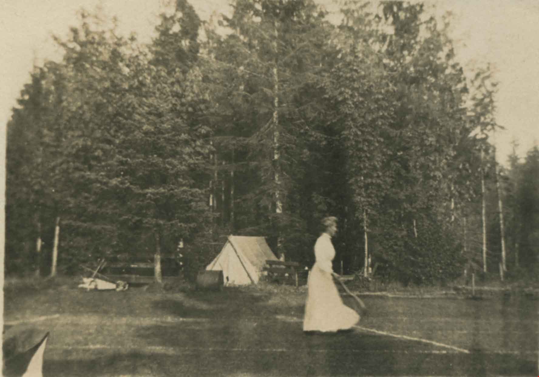
Tennis at Broadview
https://search.heritageburnaby.ca/link/archivedescription39425
- Repository
- City of Burnaby Archives
- Date
- 1910
- Collection/Fonds
- Peers Family and Hill Family fonds
- Description Level
- Item
- Physical Description
- 1 photograph : b&w ; 5.9 x 7.9 cm
- Scope and Content
- Photograph of an unidentified woman playing tennis at Broadview, the home of Claude Hill. A tent is visible in the background.
- Repository
- City of Burnaby Archives
- Date
- 1910
- Collection/Fonds
- Peers Family and Hill Family fonds
- Physical Description
- 1 photograph : b&w ; 5.9 x 7.9 cm
- Description Level
- Item
- Record No.
- 477-744
- Access Restriction
- No restrictions
- Reproduction Restriction
- No known restrictions
- Accession Number
- 2007-12
- Scope and Content
- Photograph of an unidentified woman playing tennis at Broadview, the home of Claude Hill. A tent is visible in the background.
- Subjects
- Sports - Tennis
- Structures - Tents
- Media Type
- Photograph
- Notes
- Title based on caption accompanying photograph
- Geographic Access
- Buckingham Avenue
- Street Address
- 5730 Buckingham Avenue
- Historic Neighbourhood
- Burnaby Lake (Historic Neighbourhood)
- Planning Study Area
- Morley-Buckingham Area
Images