Narrow Results By
Subject
- Advertising Medium - Signs and Signboards 5
- Agriculture 1
- Buildings - Commercial - Grocery Stores 2
- Buildings - Commercial - Stores 1
- Buildings - Industrial - Mills 2
- Buildings - Residences - Houses 1
- Buildings - Residential - Houses 2
- Education 1
- Geographic Features - Automobile Parking Lots 1
- Land Clearing 3
- Natural Phenomena - Snow 1
- Occupations - Entrepreneurs 1

Pandemic Litter
https://search.heritageburnaby.ca/link/archivedescription95131
- Repository
- City of Burnaby Archives
- Date
- April 30, 2020
- Collection/Fonds
- Burnaby Photographic Society fonds
- Description Level
- Item
- Physical Description
- 1 photograph (tiff)
- Scope and Content
- Photograph of two blue rubber gloves discarded on the ground of the Kensington Square Shopping Centre parking lot in North Burnaby.
- Repository
- City of Burnaby Archives
- Date
- April 30, 2020
- Collection/Fonds
- Burnaby Photographic Society fonds
- Physical Description
- 1 photograph (tiff)
- Description Level
- Item
- Record No.
- 623-049
- Access Restriction
- No restrictions
- Reproduction Restriction
- No restrictions
- Accession Number
- 2020-10
- Scope and Content
- Photograph of two blue rubber gloves discarded on the ground of the Kensington Square Shopping Centre parking lot in North Burnaby.
- Media Type
- Photograph
- Photographer
- Lapierre, Soleil
- Notes
- Transcribed title
- Geographic Access
- Hastings Street
- Street Address
- 6500 Hastings Street
- Historic Neighbourhood
- Lochdale (Historic Neighbourhood)
- Planning Study Area
- Lochdale Area
Images

Thank You Letter Carrier
https://search.heritageburnaby.ca/link/archivedescription95132
- Repository
- City of Burnaby Archives
- Date
- April 29, 2020
- Collection/Fonds
- Burnaby Photographic Society fonds
- Description Level
- Item
- Physical Description
- 1 photograph (tiff)
- Scope and Content
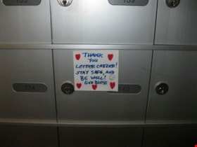
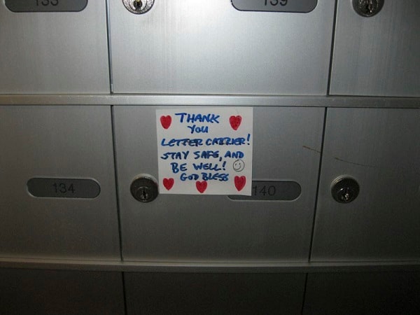
- Photograph of a handwritten sign taped to a postbox at 7072 Inlet Drive. The sign is decorated with hearts and a smiley face and reads "Thank you letter carrier! Stay safe, and be well! God bless".
- Repository
- City of Burnaby Archives
- Date
- April 29, 2020
- Collection/Fonds
- Burnaby Photographic Society fonds
- Physical Description
- 1 photograph (tiff)
- Description Level
- Item
- Record No.
- 623-050
- Access Restriction
- No restrictions
- Reproduction Restriction
- Reproduce for fair dealing purposes only
- Accession Number
- 2020-10
- Scope and Content
- Photograph of a handwritten sign taped to a postbox at 7072 Inlet Drive. The sign is decorated with hearts and a smiley face and reads "Thank you letter carrier! Stay safe, and be well! God bless".
- Media Type
- Photograph
- Photographer
- Lapierre, Soleil
- Notes
- Transcribed title
- Geographic Access
- Inlet Drive
- Street Address
- 7072 Inlet Drive
- Historic Neighbourhood
- Lochdale (Historic Neighbourhood)
- Planning Study Area
- Westridge Area
Images

Chalk drawings in support of public health workers
https://search.heritageburnaby.ca/link/museumdescription14737
- Repository
- Burnaby Village Museum
- Date
- 9 Apr. 2020
- Collection/Fonds
- Burnaby Village Museum COVID-19 collection
- Description Level
- Item
- Physical Description
- 1 photograph (jpg) : col. ; 72 dpi.
- Scope and Content
- Photograph of a basketball court in Montecito Park with coloured chalk drawings with hearts and the words "Thank you!!" and "Stay Safe!". These messages were created in support of public health workers during the beginning of the COVID-19 pandemic in British Columbia. The basketball court was close…
- Repository
- Burnaby Village Museum
- Collection/Fonds
- Burnaby Village Museum COVID-19 collection
- Description Level
- Item
- Physical Description
- 1 photograph (jpg) : col. ; 72 dpi.
- Scope and Content
- Photograph of a basketball court in Montecito Park with coloured chalk drawings with hearts and the words "Thank you!!" and "Stay Safe!". These messages were created in support of public health workers during the beginning of the COVID-19 pandemic in British Columbia. The basketball court was closed down along with other parks by the City of Burnaby in the spring of 2020 due to the COVID-19 pandemic and public health orders. The shadow of the photographer is visible in the foreground.
- History
- Tristan Johnson took photos around Burnaby because as a parent of two elementary school aged children during the COVID-19 pandemic, one of the most notable things about COVID-19 during Spring 2020 was the closure of playgrounds and the playgrounds being taped up.
- Accession Code
- BV020.21.2
- Access Restriction
- No restrictions
- Reproduction Restriction
- No known restrictions
- Date
- 9 Apr. 2020
- Media Type
- Photograph
- Historic Neighbourhood
- Lochdale (Historic Neighbourhood)
- Planning Study Area
- Sperling-Broadway Area
- Photographer
- Johnson, Tristan
- Notes
- Title based on contents of photograph
Images


Playground at Sperling Elementary School
https://search.heritageburnaby.ca/link/museumdescription14738
- Repository
- Burnaby Village Museum
- Date
- 9 Apr. 2020
- Collection/Fonds
- Burnaby Village Museum COVID-19 collection
- Description Level
- Item
- Physical Description
- 1 photograph (jpg) : col. ; 72 dpi.
- Scope and Content
- Photograph of the playground outside of Sperling Elementary School in Burnaby. The playground equipment is surrounded by yellow caution tape to prevent anyone from using it. The playground was closed down along with other parks by the City of Burnaby in the spring of 2020 due to the COVID-19 pandem…
- Repository
- Burnaby Village Museum
- Collection/Fonds
- Burnaby Village Museum COVID-19 collection
- Description Level
- Item
- Physical Description
- 1 photograph (jpg) : col. ; 72 dpi.
- Scope and Content
- Photograph of the playground outside of Sperling Elementary School in Burnaby. The playground equipment is surrounded by yellow caution tape to prevent anyone from using it. The playground was closed down along with other parks by the City of Burnaby in the spring of 2020 due to the COVID-19 pandemic and public health orders.
- History
- Tristan Johnson took photos around Burnaby because as a parent of two elementary school aged children during the COVID-19 pandemic, one of the most notable things about COVID-19 during Spring 2020 was the closure of playgrounds and the playgrounds being taped up.
- Names
- Sperling Avenue School
- Accession Code
- BV020.21.3
- Access Restriction
- No restrictions
- Reproduction Restriction
- No known restrictions
- Date
- 9 Apr. 2020
- Media Type
- Photograph
- Historic Neighbourhood
- Lochdale (Historic Neighbourhood)
- Planning Study Area
- Sperling-Broadway Area
- Photographer
- Johnson, Tristan
- Notes
- Title based on contents of photograph
Images


Playground in Montecito Park
https://search.heritageburnaby.ca/link/museumdescription14739
- Repository
- Burnaby Village Museum
- Date
- 9 Apr. 2020
- Collection/Fonds
- Burnaby Village Museum COVID-19 collection
- Description Level
- Item
- Physical Description
- 1 photograph (jpg) : col. ; 72 dpi.
- Scope and Content
- Photograph of the playground inside of Montecito Park in Burnaby. The playground equipment is surrounded by yellow caution tape to prevent anyone from using it. The playground was closed down along with other parks by the City of Burnaby in the spring of 2020 due to the COVID-19 pandemic and public…
- Repository
- Burnaby Village Museum
- Collection/Fonds
- Burnaby Village Museum COVID-19 collection
- Description Level
- Item
- Physical Description
- 1 photograph (jpg) : col. ; 72 dpi.
- Scope and Content
- Photograph of the playground inside of Montecito Park in Burnaby. The playground equipment is surrounded by yellow caution tape to prevent anyone from using it. The playground was closed down along with other parks by the City of Burnaby in the spring of 2020 due to the COVID-19 pandemic and public health orders.
- History
- Tristan Johnson took photos around Burnaby because as a parent of two elementary school aged children during the COVID-19 pandemic, one of the most notable things about COVID-19 during Spring 2020 was the closure of playgrounds and the playgrounds being taped up.
- Names
- Sperling Avenue School
- Accession Code
- BV020.21.4
- Access Restriction
- No restrictions
- Reproduction Restriction
- No known restrictions
- Date
- 9 Apr. 2020
- Media Type
- Photograph
- Historic Neighbourhood
- Lochdale (Historic Neighbourhood)
- Planning Study Area
- Sperling-Broadway Area
- Photographer
- Johnson, Tristan
- Notes
- Title based on contents of photograph
Images


COVID-19 signage in Super Valu store
https://search.heritageburnaby.ca/link/museumdescription15358
- Repository
- Burnaby Village Museum
- Date
- 6 May 2020
- Collection/Fonds
- Burnaby Village Museum COVID-19 collection
- Description Level
- Item
- Physical Description
- 1 photograph (jpg)
- Scope and Content
- Photograph of COVID-19 signage inside the Greystone Super Valu grocery store located on Burnwood Drive in Burnaby. The sign on pink paper between store aisles reads: "This Walkway Closed for Physical distancing".
- Repository
- Burnaby Village Museum
- Collection/Fonds
- Burnaby Village Museum COVID-19 collection
- Description Level
- Item
- Physical Description
- 1 photograph (jpg)
- Scope and Content
- Photograph of COVID-19 signage inside the Greystone Super Valu grocery store located on Burnwood Drive in Burnaby. The sign on pink paper between store aisles reads: "This Walkway Closed for Physical distancing".
- Subjects
- Advertising Medium - Signs and Signboards
- Buildings - Commercial - Grocery Stores
- Pandemics - COVID-19
- Names
- Super Valu
- Geographic Access
- Burnwood Drive
- Street Address
- 1601 Burnwood Drive
- Accession Code
- BV021.2.20
- Access Restriction
- No restrictions
- Reproduction Restriction
- May be restricted by third party rights
- Date
- 6 May 2020
- Media Type
- Photograph
- Historic Neighbourhood
- Lochdale (Historic Neighbourhood)
- Planning Study Area
- Sperling-Broadway Area
- Notes
- Title based on contents of photograph
Images


COVID-19 signage outside of Burnaby Mountain Golf Course
https://search.heritageburnaby.ca/link/museumdescription15359
- Repository
- Burnaby Village Museum
- Date
- 6 May 2020
- Collection/Fonds
- Burnaby Village Museum COVID-19 collection
- Description Level
- Item
- Physical Description
- 1 photograph (jpg)
- Scope and Content
- Photograph of COVID-19 signage outside of the Burnaby Mountain Golf Course and Driving Range. Sandwhich board sign reads: "Check In / Attention Golfers / We request that all golfers / stay in the parking lot area / until 15 minutes prior to their tea time".
- Repository
- Burnaby Village Museum
- Collection/Fonds
- Burnaby Village Museum COVID-19 collection
- Description Level
- Item
- Physical Description
- 1 photograph (jpg)
- Scope and Content
- Photograph of COVID-19 signage outside of the Burnaby Mountain Golf Course and Driving Range. Sandwhich board sign reads: "Check In / Attention Golfers / We request that all golfers / stay in the parking lot area / until 15 minutes prior to their tea time".
- Subjects
- Advertising Medium - Signs and Signboards
- Recreational Activities - Golf
- Pandemics - COVID-19
- Geographic Access
- Halifax Street
- Street Address
- 7600 Halifax Street
- Accession Code
- BV021.2.21
- Access Restriction
- No restrictions
- Reproduction Restriction
- May be restricted by third party rights
- Date
- 6 May 2020
- Media Type
- Photograph
- Historic Neighbourhood
- Lochdale (Historic Neighbourhood)
- Planning Study Area
- Sperling-Broadway Area
- Notes
- Title based on contents of photograph
Images


COVID-19 signage outside of Burnaby Mountain Golf Course
https://search.heritageburnaby.ca/link/museumdescription15360
- Repository
- Burnaby Village Museum
- Date
- 6 May 2020
- Collection/Fonds
- Burnaby Village Museum COVID-19 collection
- Description Level
- Item
- Physical Description
- 1 photograph (jpg)
- Scope and Content
- Photograph of COVID-19 signage outside of the Burnaby Mountain Golf Course and Driving Range. Sign located in front garden at entrance road to the golf course reads: "Do Your Part / Stay Apart..." and includes an illustration of two figures standing two metres apart.
- Repository
- Burnaby Village Museum
- Collection/Fonds
- Burnaby Village Museum COVID-19 collection
- Description Level
- Item
- Physical Description
- 1 photograph (jpg)
- Scope and Content
- Photograph of COVID-19 signage outside of the Burnaby Mountain Golf Course and Driving Range. Sign located in front garden at entrance road to the golf course reads: "Do Your Part / Stay Apart..." and includes an illustration of two figures standing two metres apart.
- Subjects
- Advertising Medium - Signs and Signboards
- Recreational Activities - Golf
- Pandemics - COVID-19
- Geographic Access
- Halifax Street
- Street Address
- 7600 Halifax Street
- Accession Code
- BV021.2.22
- Access Restriction
- No restrictions
- Reproduction Restriction
- May be restricted by third party rights
- Date
- 6 May 2020
- Media Type
- Photograph
- Historic Neighbourhood
- Lochdale (Historic Neighbourhood)
- Planning Study Area
- Sperling-Broadway Area
- Notes
- Title based on contents of photograph
Images


COVID-19 signage outside of Burnaby Mountain Golf Course
https://search.heritageburnaby.ca/link/museumdescription15361
- Repository
- Burnaby Village Museum
- Date
- 6 May 2020
- Collection/Fonds
- Burnaby Village Museum COVID-19 collection
- Description Level
- Item
- Physical Description
- 1 photograph (jpg)
- Scope and Content
- Photograph of COVID-19 signage at the Burnaby Mountain Golf Course and Driving Range. Signage is hanging on roped off area outside of putting greens near the clubhouse. Signs read "Practice Greens / Closed".
- Repository
- Burnaby Village Museum
- Collection/Fonds
- Burnaby Village Museum COVID-19 collection
- Description Level
- Item
- Physical Description
- 1 photograph (jpg)
- Scope and Content
- Photograph of COVID-19 signage at the Burnaby Mountain Golf Course and Driving Range. Signage is hanging on roped off area outside of putting greens near the clubhouse. Signs read "Practice Greens / Closed".
- Subjects
- Advertising Medium - Signs and Signboards
- Recreational Activities - Golf
- Pandemics - COVID-19
- Geographic Access
- Halifax Street
- Street Address
- 7600 Halifax Street
- Accession Code
- BV021.2.23
- Access Restriction
- No restrictions
- Reproduction Restriction
- May be restricted by third party rights
- Date
- 6 May 2020
- Media Type
- Photograph
- Historic Neighbourhood
- Lochdale (Historic Neighbourhood)
- Planning Study Area
- Sperling-Broadway Area
- Notes
- Title based on contents of photograph
Images

Mayor Hurley in Super Valu
https://search.heritageburnaby.ca/link/museumdescription15366
- Repository
- Burnaby Village Museum
- Date
- 6 May 2020
- Collection/Fonds
- Burnaby Village Museum COVID-19 collection
- Description Level
- Item
- Physical Description
- 1 photograph (jpg)
- Scope and Content
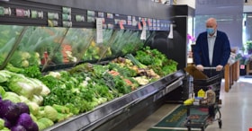
- Photograph of a Burnaby Mayor Mike Hurley pushing a shopping cart in the produce section of the Super Valu grocery store on Burnwood Drive in Burnaby. The mayor is wearing a disposable face mask.
- Repository
- Burnaby Village Museum
- Collection/Fonds
- Burnaby Village Museum COVID-19 collection
- Description Level
- Item
- Physical Description
- 1 photograph (jpg)
- Scope and Content
- Photograph of a Burnaby Mayor Mike Hurley pushing a shopping cart in the produce section of the Super Valu grocery store on Burnwood Drive in Burnaby. The mayor is wearing a disposable face mask.
- Names
- Super Valu
- Hurley, Mike
- Geographic Access
- Burnwood Drive
- Street Address
- 1601 Burnwood Drive
- Accession Code
- BV021.2.28
- Access Restriction
- No restrictions
- Reproduction Restriction
- May be restricted by third party rights
- Date
- 6 May 2020
- Media Type
- Photograph
- Historic Neighbourhood
- Lochdale (Historic Neighbourhood)
- Planning Study Area
- Sperling-Broadway Area
- Notes
- Title based on contents of photograph
Images

![Dow General Store, [193-]. Item no. HV976.62.1 thumbnail](/media/hpo/_Data/_Archives_Images/_Unrestricted/1974/197600620001.jpg?width=280)
Interview with A.W. Dow by Larry R. Jensen November 11, 1974 - Track 3
https://search.heritageburnaby.ca/link/oralhistory162
- Repository
- City of Burnaby Archives
- Date Range
- 1929
- Length
- 0:08:02
- Summary
- This portion of the interview pertains to A.W. Dow's memories of fellow Lochdale residents, based on the reading of 1929 address listings.
- Repository
- City of Burnaby Archives
- Summary
- This portion of the interview pertains to A.W. Dow's memories of fellow Lochdale residents, based on the reading of 1929 address listings.
- Date Range
- 1929
- Photo Info
- Dow General Store, [193-]. Item no. HV976.62.1
- Length
- 0:08:02
- Historic Neighbourhood
- Lochdale (Historic Neighbourhood)
- Interviewer
- Jensen, Larry R.
- Interview Date
- November 11, 1974
- Scope and Content
- Recording is of an interview with A.W. Dow by history student Larry R. Jensen, November 11, 1974. This interview was created to gain information for a History 432 paper entitled: "The Lochdale Community: A Study of Depression Times (1929-1939)." Major themes discussed are: the Lochdale Community and the Depression.
- Biographical Notes
- A.W. Dow went to boarding school in Truro, Cornwall, United Kingdom. A.W. Dow came to the Lochdale Community in 1928. He learnt of the Lochdale store being up for sale through his bride-to-be’s brother, bought it, and became the postmaster and Lochdale General Store owner from 1928 until 1937, renaming it Dow's General Store. In 1937, he and his wife left the store at Hastings Street, bought property and built a combination house and store at 599 Sperling Avenue. A.W. served as Secretary and Treasurer of the Rate Payers' Association. As well, he and his wife were charter members of the Lochdale Co-operative Commonwealth Federation (CCF).
- Total Tracks
- 7
- Total Length
- 0:58:39
- Interviewee Name
- Dow, A.W.
- Interview Location
- 599 Sperling Avenue, Burnaby
- Collection/Fonds
- Burnaby Historical Society fonds
- Subseries
- Oral history subseries
- Media Type
- Sound Recording
- Web Notes
- Interview was digitized in 2010 allowing it to be accessible on Heritage Burnaby. The digitization project was initiated by the Community Heritage Commission with support from City of Burnaby Council and the BC History Digitization Program of the Irving K. Barber Learning Centre, University of British Columbia. It was recognized by the Heritage Society of BC with an award in 2012.
Images
![Dow General Store, [193-]. Item no. HV976.62.1 thumbnail](/media/hpo/_Data/_Archives_Images/_Unrestricted/1974/197600620001.jpg)
Audio Tracks
Track three of interview with A.W. Dow
Track three of interview with A.W. Dow
https://search.heritageburnaby.ca/media/hpo/_Data/_Archives_Oral_Histories/_Unrestricted/100-13-05/100-13-05_Track_3.mp3
Interview with A.W. Dow by Larry R. Jensen November 11, 1974 - Track 4
https://search.heritageburnaby.ca/link/oralhistory163
- Repository
- City of Burnaby Archives
- Date Range
- 1929-1932
- Length
- 0:09:08
- Summary
- This portion of the interview pertains to A.W. Dow's memories of the development of the Lochdale Community Hall as well as continuing descriptions of residents from the 1929 address listings. He also begins discussing script as payment.
- Repository
- City of Burnaby Archives
- Summary
- This portion of the interview pertains to A.W. Dow's memories of the development of the Lochdale Community Hall as well as continuing descriptions of residents from the 1929 address listings. He also begins discussing script as payment.
- Date Range
- 1929-1932
- Photo Info
- Dow General Store, [193-]. Item no. HV976.62.1
- Length
- 0:09:08
- Names
- Lochdale Community Hall
- Historic Neighbourhood
- Lochdale (Historic Neighbourhood)
- Interviewer
- Jensen, Larry R.
- Interview Date
- November 11, 1974
- Scope and Content
- Recording is of an interview with A.W. Dow by history student Larry R. Jensen, November 11, 1974. This interview was created to gain information for a History 432 paper entitled: "The Lochdale Community: A Study of Depression Times (1929-1939)." Major themes discussed are: the Lochdale Community and the Depression.
- Biographical Notes
- A.W. Dow went to boarding school in Truro, Cornwall, United Kingdom. A.W. Dow came to the Lochdale Community in 1928. He learnt of the Lochdale store being up for sale through his bride-to-be’s brother, bought it, and became the postmaster and Lochdale General Store owner from 1928 until 1937, renaming it Dow's General Store. In 1937, he and his wife left the store at Hastings Street, bought property and built a combination house and store at 599 Sperling Avenue. A.W. served as Secretary and Treasurer of the Rate Payers' Association. As well, he and his wife were charter members of the Lochdale Co-operative Commonwealth Federation (CCF).
- Total Tracks
- 7
- Total Length
- 0:58:39
- Interviewee Name
- Dow, A.W.
- Interview Location
- 599 Sperling Avenue, Burnaby
- Collection/Fonds
- Burnaby Historical Society fonds
- Subseries
- Oral history subseries
- Media Type
- Sound Recording
- Web Notes
- Interview was digitized in 2010 allowing it to be accessible on Heritage Burnaby. The digitization project was initiated by the Community Heritage Commission with support from City of Burnaby Council and the BC History Digitization Program of the Irving K. Barber Learning Centre, University of British Columbia. It was recognized by the Heritage Society of BC with an award in 2012.
Images
Audio Tracks
Track four of interview with A.W. Dow
Track four of interview with A.W. Dow
https://search.heritageburnaby.ca/media/hpo/_Data/_Archives_Oral_Histories/_Unrestricted/100-13-05/100-13-05_Track_4.mp3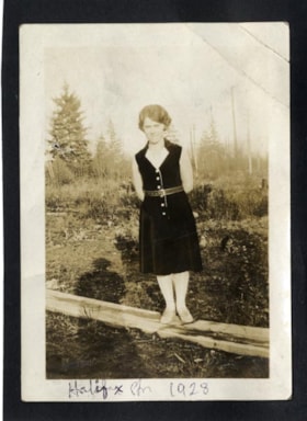
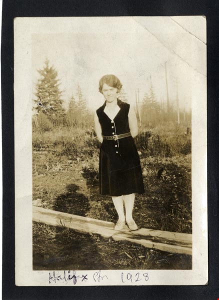
Halifax Str 1928
https://search.heritageburnaby.ca/link/archivedescription97956
- Repository
- City of Burnaby Archives
- Date
- 1928
- Collection/Fonds
- Burnaby Historical Society fonds
- Description Level
- Item
- Physical Description
- 1 photograph : b&w ; 9 cm x 7 cm mounted on black paper 10 cm x 7 cm
- Scope and Content
- Photograph of Dorothy Easthope in the garden at 6671 Halifax Street. She is standing on a wooden plank in the garden, wearing a black belted dress and posed with her hands behind her back.
- Repository
- City of Burnaby Archives
- Date
- 1928
- Collection/Fonds
- Burnaby Historical Society fonds
- Subseries
- Easthope family subseries
- Physical Description
- 1 photograph : b&w ; 9 cm x 7 cm mounted on black paper 10 cm x 7 cm
- Description Level
- Item
- Record No.
- 451-023
- Access Restriction
- No restrictions
- Reproduction Restriction
- No known restrictions
- Accession Number
- BHS2003-06
- Scope and Content
- Photograph of Dorothy Easthope in the garden at 6671 Halifax Street. She is standing on a wooden plank in the garden, wearing a black belted dress and posed with her hands behind her back.
- Media Type
- Photograph
- Notes
- Transcribed title
- Title transcribed from note on verso of photograph
- Geographic Access
- Halifax Street
- Street Address
- 6671 Halifax Street
- Historic Neighbourhood
- Lochdale (Historic Neighbourhood)
- Planning Study Area
- Lochdale Area
Images
Interview with A.W. Dow by Larry R. Jensen November 11, 1974 - Track 1
https://search.heritageburnaby.ca/link/oralhistory160
- Repository
- City of Burnaby Archives
- Date Range
- 1928-1930
- Length
- 0:09:18
- Summary
- This portion of the interview pertains to A.W. Dow's purchase of the Lochdale General Store and the community members that became his customers. He mentions the closure of the Barnet Mill.
- Repository
- City of Burnaby Archives
- Summary
- This portion of the interview pertains to A.W. Dow's purchase of the Lochdale General Store and the community members that became his customers. He mentions the closure of the Barnet Mill.
- Date Range
- 1928-1930
- Photo Info
- Dow General Store, [193-]. Item no. HV976.62.1
- Length
- 0:09:18
- Subjects
- Buildings - Commercial - Stores
- Historic Neighbourhood
- Lochdale (Historic Neighbourhood)
- Interviewer
- Jensen, Larry R.
- Interview Date
- November 11, 1974
- Scope and Content
- Recording is of an interview with A.W. Dow by history student Larry R. Jensen, November 11, 1974. This interview was created to gain information for a History 432 paper entitled: "The Lochdale Community: A Study of Depression Times (1929-1939)." Major themes discussed are: the Lochdale Community and the Depression.
- Biographical Notes
- A.W. Dow went to boarding school in Truro, Cornwall, United Kingdom. A.W. Dow came to the Lochdale Community in 1928. He learnt of the Lochdale store being up for sale through his bride-to-be’s brother, bought it, and became the postmaster and Lochdale General Store owner from 1928 until 1937, renaming it Dow's General Store. In 1937, he and his wife left the store at Hastings Street, bought property and built a combination house and store at 599 Sperling Avenue. A.W. served as Secretary and Treasurer of the Rate Payers' Association. As well, he and his wife were charter members of the Lochdale Co-operative Commonwealth Federation (CCF).
- Total Tracks
- 7
- Total Length
- 0:58:39
- Interviewee Name
- Dow, A.W.
- Interview Location
- 599 Sperling Avenue, Burnaby
- Collection/Fonds
- Burnaby Historical Society fonds
- Subseries
- Oral history subseries
- Media Type
- Sound Recording
- Web Notes
- Interview was digitized in 2010 allowing it to be accessible on Heritage Burnaby. The digitization project was initiated by the Community Heritage Commission with support from City of Burnaby Council and the BC History Digitization Program of the Irving K. Barber Learning Centre, University of British Columbia. It was recognized by the Heritage Society of BC with an award in 2012.
Images
Audio Tracks
Track one of interview with A.W. Dow
Track one of interview with A.W. Dow
https://search.heritageburnaby.ca/media/hpo/_Data/_Archives_Oral_Histories/_Unrestricted/100-13-05/100-13-05_Track_1.mp3
Municipality of Burnaby - Volume XV and Volume XVIII
https://search.heritageburnaby.ca/link/museumdescription8680
- Repository
- Burnaby Village Museum
- Date
- May 1927
- Collection/Fonds
- Burnaby Village Museum Map collection
- Description Level
- File
- Physical Description
- 4 plans on 4 sheets : col. lithographic prints ; 63.5 x 53.5 cm folded to 53 x 31.5 cm
- Scope and Content
- File consists of four pages of plans removed from a bound book containing a series of fire insurance plans of the Municipality of Burnaby. The first two pages are numbered "A" and "B" and are key plans from "GREATER VANCOUVER B.C. / VOLUME XV / Surveyed _ May 1927 / MUNICIPALITY OF / BURNABY", "PLA…
- Repository
- Burnaby Village Museum
- Collection/Fonds
- Burnaby Village Museum Map collection
- Description Level
- File
- Physical Description
- 4 plans on 4 sheets : col. lithographic prints ; 63.5 x 53.5 cm folded to 53 x 31.5 cm
- Material Details
- Scales [1:1200] and [1:6000]
- Scope and Content
- File consists of four pages of plans removed from a bound book containing a series of fire insurance plans of the Municipality of Burnaby. The first two pages are numbered "A" and "B" and are key plans from "GREATER VANCOUVER B.C. / VOLUME XV / Surveyed _ May 1927 / MUNICIPALITY OF / BURNABY", "PLAN DEPT. FIRE BRANCH _ B.C. INSURANCE UNDERWRITERS ASSN.". Key Plan "B" covers plans: 1505; 1506; 1512 to 1516; 1540 to 1544; 1550 to 1557 and District Lots: 129 to 132; 135 to 138; 205 to 208 and 215 to 218. Key Plan "A" covers plans: 1501 to 1504; 1507 to 1511; 1517 to 1525; 1531 to 1539; 1545 to 1550 and District Lots: 116 to 127 and 186 to 189. Plan "1806" is part of "GREATER VANCOUVER B.C. / VOLUME XVIII / Municipality of Burnaby / May, 1927" and covers District Lot 153. Plan "1807" is from "GREATER VANCOUVER B.C. / VOLUME XVIII / Municipality of Burnaby / May, 1927" and covers District Lots: 99,149 and 152.
- Responsibility
- British Columbia Underwriters' Association
- Accession Code
- HV972.111.2
- Access Restriction
- No restrictions
- Reproduction Restriction
- May be restricted by third party rights
- Date
- May 1927
- Media Type
- Cartographic Material
- Historic Neighbourhood
- Vancouver Heights (Historic Neighbourhood)
- Lochdale (Historic Neighbourhood)
- Capitol Hill (Historic Neighbourhood)
- Central Park (Historic Neighbourhood)
- Alta Vista (Historic Neighbourhood)
- Planning Study Area
- Burnaby Heights Area
- Sperling-Broadway Area
- Lochdale Area
- Parkcrest-Aubrey Area
- Westridge Area
- Willingdon Heights Area
- Capitol Hill Area
- Maywood Area
- Marlborough Area
- Scan Resolution
- 400
- Scan Date
- 2021-11-18
- Notes
- Title based on content of plans
- Scales are measured 1 inch = 100 feet and 1 inch = 500 feet
- See also BV987.1.70d for revised versions of plans
Zoomable Images


![William Kask, Sr., [between 1925 and 1929] (date of original), copied 1991 thumbnail](/media/hpo/_Data/_Archives_Images/_Unrestricted/370/370-006.jpg?width=280)
William Kask, Sr.
https://search.heritageburnaby.ca/link/archivedescription37418
- Repository
- City of Burnaby Archives
- Date
- [between 1925 and 1929] (date of original), copied 1991
- Collection/Fonds
- Burnaby Historical Society fonds
- Description Level
- Item
- Physical Description
- 1 photograph : b&w ; 2.9 x 4.9 cm print on contact sheet 20.2 x 25.4 cm
- Scope and Content
- Photograph of William "Bill" Kask, Sr., standing in front of a tree at Alex Kask's home at Hastings Street and Kensington Avenue. The property later became the site of a Shell filling station.
- Repository
- City of Burnaby Archives
- Date
- [between 1925 and 1929] (date of original), copied 1991
- Collection/Fonds
- Burnaby Historical Society fonds
- Subseries
- Burnaby Image Bank subseries
- Physical Description
- 1 photograph : b&w ; 2.9 x 4.9 cm print on contact sheet 20.2 x 25.4 cm
- Description Level
- Item
- Record No.
- 370-006
- Access Restriction
- No restrictions
- Reproduction Restriction
- No restrictions
- Accession Number
- BHS1999-03
- Scope and Content
- Photograph of William "Bill" Kask, Sr., standing in front of a tree at Alex Kask's home at Hastings Street and Kensington Avenue. The property later became the site of a Shell filling station.
- Subjects
- Occupations - Entrepreneurs
- Media Type
- Photograph
- Notes
- Title based on contents of photograph
- 1 b&w copy negative accompanying
- Geographic Access
- Hastings Street
- Kensington Avenue
- Historic Neighbourhood
- Lochdale (Historic Neighbourhood)
- Planning Study Area
- Westridge Area
Images
![William Kask, Sr., [between 1925 and 1929] (date of original), copied 1991 thumbnail](/media/hpo/_Data/_Archives_Images/_Unrestricted/370/370-006.jpg)
![805 Grove Avenue, [1925] (date of original), copied 1991 thumbnail](/media/hpo/_Data/_Archives_Images/_Unrestricted/370/370-274.jpg?width=280)
805 Grove Avenue
https://search.heritageburnaby.ca/link/archivedescription37686
- Repository
- City of Burnaby Archives
- Date
- [1925] (date of original), copied 1991
- Collection/Fonds
- Burnaby Historical Society fonds
- Description Level
- Item
- Physical Description
- 1 photograph : b&w ; 2.9 x 5.0 cm print on contact sheet 20.2 x 25.3 cm
- Scope and Content
- Photograph of the exterior of the house at 805 Grove Avenue.
- Repository
- City of Burnaby Archives
- Date
- [1925] (date of original), copied 1991
- Collection/Fonds
- Burnaby Historical Society fonds
- Subseries
- Burnaby Image Bank subseries
- Physical Description
- 1 photograph : b&w ; 2.9 x 5.0 cm print on contact sheet 20.2 x 25.3 cm
- Description Level
- Item
- Record No.
- 370-274
- Access Restriction
- No restrictions
- Reproduction Restriction
- No known restrictions
- Accession Number
- BHS1999-03
- Scope and Content
- Photograph of the exterior of the house at 805 Grove Avenue.
- Subjects
- Buildings - Residential - Houses
- Media Type
- Photograph
- Notes
- Title based on contents of photograph
- 1 b&w copy negative accompanying
- Negative has a pink cast
- Geographic Access
- Grove Avenue
- Street Address
- 805 Grove Avenue
- Historic Neighbourhood
- Lochdale (Historic Neighbourhood)
- Planning Study Area
- Lochdale Area
Images
![805 Grove Avenue, [1925] (date of original), copied 1991 thumbnail](/media/hpo/_Data/_Archives_Images/_Unrestricted/370/370-274.jpg)
Interview with Leonard Evenden and Allen Seager by Kathy Bossort November 18, 2015 - Track 1
https://search.heritageburnaby.ca/link/oralhistory621
- Repository
- City of Burnaby Archives
- Date Range
- 1925-2015
- Length
- 0:12:50
- Summary
- This portion of the interview is about Dr. Evenden and Dr. Seager’s description of their early years at Simon Fraser University. They talk about the challenges to commuting up and down Burnaby Mountain and the solutions people used, particularly hitchhiking. Dr. Seager talks about living in Monteci…
- Repository
- City of Burnaby Archives
- Summary
- This portion of the interview is about Dr. Evenden and Dr. Seager’s description of their early years at Simon Fraser University. They talk about the challenges to commuting up and down Burnaby Mountain and the solutions people used, particularly hitchhiking. Dr. Seager talks about living in Montecito in the 1980s. Dr. Evenden talks about the early use of Burnaby Mountain and its undeveloped state when the site for SFU was proposed in 1963.
- Date Range
- 1925-2015
- Length
- 0:12:50
- Names
- Simon Fraser University
- Subjects
- Education
- Transportation
- Geographic Access
- Burnaby Mountain Conservation Area
- Historic Neighbourhood
- Lochdale (Historic Neighbourhood)
- Planning Study Area
- Sperling-Broadway Area
- Interviewer
- Bossort, Kathy
- Interview Date
- November 18, 2015
- Scope and Content
- Recording is of an interview with Dr. Leonard Evenden and Dr. Allen Seager conducted by Kathy Bossort. Leonard Evenden and Allen Seager were two of 23 participants interviewed as part of the Community Heritage Commission’s Burnaby Mountain Oral History Project. The interview is mainly about aspects of Simon Fraser University’s history that is related to its site on Burnaby Mountain, as told by two retired SFU professors, Dr. Evenden of the Geography Department and Dr. Seager of the Department of History. The interview ranges over campus access and housing issues created by the isolated mountain site; the relationship of the university to the local community and the dispute over land ownership and control with the City of Burnaby; SFU’s environmental stewardship; the development of UniverCity; and the future of parkland in the conservation area on Burnaby Mountain.
- Biographical Notes
- Dr. Leonard J. Evenden was born 1937 in Beijing, China, to parents and Salvation Army missionaries Leonard Evenden and Elsie Pearl March. Dr. Evenden attended McMaster University (B.A. 1960), University of Georgia (M.A. 1962) and University of Edinburgh (Ph.D. 1970). He was appointed to Simon Fraser University’s Department of Geography in 1966, shortly after SFU opened in the fall of 1965, and retired in 2002. Dr. Evenden’s research has focused on Canadian urban geography. He edited a collection of essays about Burnaby titled “Suburb of Happy Homes: Burnaby centennial themes” (1995), and directed “Voices of Burnaby”, an SFU/Burnaby Centennial Committee oral history project (1992). Dr. Evenden is married with three children. Dr. Allen Seager was born 1953 in Montreal, Quebec, to parents C.F.B. Seager and Evelyn DeGex Chesam. Dr. Seager is a retired Simon Fraser University professor, being a member of SFU’s Department of History from 1981 to 2014, and has current links with SFU as an instructor for Continuing Studies. His research interests include history of Canada and Western Canada, and labour and working class history, particularly in the coal mining and railway industries. Dr. Seager moved to Burnaby and the Montecito area in 1981 where he continues to live and enjoy the hiking trails on Burnaby Mountain and the amenities at SFU. Dr. Seager is a member of the Burnaby North NDP, and has volunteered with Scouts Canada and the Burnaby Centennial Committee.
- Total Tracks
- 6
- Total Length
- 1:11:28
- Interviewee Name
- Evenden, Leonard J.
- Seager, Allen
- Interview Location
- Clubhouse at Burnaby Mountain Golf Course Restaurant
- Interviewer Bio
- Kathy Bossort is a retired archivist living in Ladner, BC. She worked at the Delta Museum and Archives after graduating from SLAIS (UBC) in 2001 with Masters degrees in library science and archival studies. Kathy grew up in Calgary, Alberta, and, prior to this career change, she lived in the West Kootenays, earning her living as a cook for BC tourist lodges and work camps. She continues to be interested in oral histories as a way to fill the gaps in the written record and bring richer meaning to history.
- Collection/Fonds
- Community Heritage Commission Special Projects fonds
- Media Type
- Sound Recording
Audio Tracks
Track one of interview with Dr. Leonard Evenden and Dr. Allen Seager
Track one of interview with Dr. Leonard Evenden and Dr. Allen Seager
https://search.heritageburnaby.ca/media/hpo/_Data/_Archives_Oral_Histories/_Unrestricted/MSS196-011/MSS196-011_Track_1.mp3
Lochdale Community Hall
https://search.heritageburnaby.ca/link/landmark549
- Repository
- Burnaby Heritage Planning
- Description
- The Lochdale Community Hall is a one-storey wood-frame building located on Sperling Avenue, near its intersection with Hastings Street, in the centre of the Lochdale district in North Burnaby. Built in stages, its current configuration has an L-shaped plan, with three different roof structures.
- Associated Dates
- 1925
- Formal Recognition
- Heritage Designation, Community Heritage Register
- Street View URL
- Google Maps Street View
- Repository
- Burnaby Heritage Planning
- Geographic Access
- Sperling Avenue
- Associated Dates
- 1925
- Formal Recognition
- Heritage Designation, Community Heritage Register
- Enactment Type
- Bylaw No. 9807
- Enactment Date
- 23/11/1992
- Description
- The Lochdale Community Hall is a one-storey wood-frame building located on Sperling Avenue, near its intersection with Hastings Street, in the centre of the Lochdale district in North Burnaby. Built in stages, its current configuration has an L-shaped plan, with three different roof structures.
- Heritage Value
- The heritage value of the Lochdale Community Hall is as Burnaby’s last remaining early community hall building. It was constructed with volunteer labour and donated materials in 1925 through the efforts of the Lochdale Social Club. The Hall is a valuable reminder of the way in which early communities banded together for mutual support at a time when transportation was more difficult and local communities were more isolated than today. This residents’ association has used this building to support the community through public political meetings, theatre, dinners and dances, creating strong community ties in North Burnaby. The Hall was also used briefly for the services of St. Margaret of Scotland Anglican parish until their church was completed in 1929, demonstrating a spirit of community cooperation at a time when local institutions were being established in the area.
- Defining Elements
- Key elements that define the heritage character of the Lochdale Community Hall include its: - central location in the Lochdale community - modest vernacular architecture and massing - stepped-pitch gable roof of the main hall - shallow-pitched gable roof of the entrance porch - Craftsman style eave brackets - central front entry - interior features such as the main open hall with an elevated stage
- Locality
- Lochdale
- Historic Neighbourhood
- Lochdale (Historic Neighbourhood)
- Planning Study Area
- Lochdale Area
- Organization
- Lochdale Social Club
- Function
- Primary Current--Recreation Centre
- Primary Historic--Recreation Centre
- Community
- Burnaby
- Cadastral Identifier
- P.I.D. No. 012-091-901 Legal Description: Lot 11 Except: East five feet , Block 6, District Lot 206, Group 1, New Westminster District, Plan 1323
- Boundaries
- The Lochdale Community Hall is comprised of a single municipally-owned property located at 490 Sperling Avenue, Burnaby.
- Area
- 1,260.00
- Contributing Resource
- Building
- Ownership
- Public (local)
- Other Collection
- St. Margaret of Scotland Parish Fonds, Anglican Diocese of New Westminster Archives.
- Documentation
- Heritage Site Files: PC77000 20. City of Burnaby Planning and Building Department, 4949 Canada Way, Burnaby, B.C., V5G 1M2
- Street Address
- 490 Sperling Avenue
- Street View URL
- Google Maps Street View
Images


Kask Brothers
https://search.heritageburnaby.ca/link/landmark684
- Repository
- Burnaby Heritage Planning
- Geographic Access
- Barnet Road
- Associated Dates
- 1925
- Heritage Value
- In 1925, William Kask Sr. and his family purchased land along the Barnet Road and built what became known as Kask's Camp, where cabins were rented out to families working at the Barnet Mill. The family - William Kask Jr., Dave and Jack - went on to expand their business into a lumber and concrete supply company and in 1936, the company was named the Kask Brothers Building Supply Company. A lumber office was established on Curtis Street and the concrete plant was built at the former site of the cabin camp. To a large degree, the camp catered to Immigrants from Nordic countries who were active in the lumber trade. Many Finns felt at home in the camp, as the Kasks spoke Finnish and there were steam baths available.
- Historic Neighbourhood
- Lochdale (Historic Neighbourhood)
- Planning Study Area
- Westridge Area
- Street Address
- 7501 Barnet Road
Images
