Narrow Results By
Creator
- Bartel, Mario 20
- Born, A. J. 2
- British Columbia Underwriters' Association 2
- Burnett & McGugan, Engineers and Surveyors 1
- Cheung, Nakita 1
- Crawford, T. James (Thomas James) 1
- Digney, Andy 2
- Disney, John Harold "Jack" 2
- Edmonds Studio 1
- Hoyer Studios 1
- Lessenberry, D. D. (David Daniel), 1896- 1
- Lloyd, Frank Ernest 1

Burnaby South High School
https://search.heritageburnaby.ca/link/landmark770
- Repository
- Burnaby Heritage Planning
- Associated Dates
- 1922-1988
- Street View URL
- Google Maps Street View
- Repository
- Burnaby Heritage Planning
- Geographic Access
- Southoaks Crescent
- Associated Dates
- 1922-1988
- Heritage Value
- Burnaby South and Burnaby North were Burnaby's first high schools. The first rooms of the school were built in 1922 on the same grounds as the Kingsway East Elementary School. In 1940, a two-storey building was erected and additions were made in 1963, 1967 and 1972. Kingsway East closed in 1925 and its buildings were used by the high school for Industrial Arts and Home Economics. In the early 1990s, a new "urban education centre" (Burnaby South/B.C. School for the Deaf) was opened, replacing the old Burnaby South High School.
- Historic Neighbourhood
- Edmonds (Historic Neighbourhood)
- Planning Study Area
- Kingsway-Beresford Area
- Street Address
- 6650 Southoaks Crescent
- Street View URL
- Google Maps Street View
Images


Kingsway-Beresford Neighbourhood
https://search.heritageburnaby.ca/link/landmark805
- Repository
- Burnaby Heritage Planning
- Associated Dates
- 1955-2008
- Heritage Value
- Since the building boom of the 1950s, the Kingsway-Beresford Neighbourhood has maintained a residential character with the exception of the Kingsway corridor, which has become a primary commercial and light industrial sector.
- Historic Neighbourhood
- Edmonds (Historic Neighbourhood)
- Planning Study Area
- Kingsway-Beresford Area
Images


20th century typewriting : complete course
https://search.heritageburnaby.ca/link/museumlibrary5012
- Repository
- Burnaby Village Museum
- Collection
- Special Collection
- Material Type
- Book
- Accession Code
- BV007.2.1
- Call Number
- 652.3 LES
- Edition
- 6th ed.
- Place of Publication
- Cincinnati
- Publisher
- South-Western Publishing Co.
- Publication Date
- c1952
- Physical Description
- 340 p. : ill. : 20 x 28 cm.
- Library Subject (LOC)
- Typewriting
- Subjects
- Documentary Artifacts - Books
- Historic Neighbourhood
- Edmonds (Historic Neighbourhood)
- Burnaby Lake (Historic Neighbourhood)
- Planning Study Area
- Kingsway-Beresford Area
- Douglas-Gilpin Area
- Geographic Access
- Canada Way
- Southoaks Crescent
- Street Address
- 4939 Canada Way
- 6650 Southoaks Crescent
- Object History
- Was used by Burnaby resident Barbara Copan when she taught typing at Burnaby Central circa 1963-65. It may have originally belonged to Barbara's mother who also taught typing at Burnaby South High School circa 1957 to 1965. She mainly taught typing in night school.
- Notes
- Authors' given name and date as follows: Lessenberry, D.D. (David Daniel), 1896- Crawford, T. James (Thomas James)
Images


![Gilley Brothers Logging team, [1895]. . thumbnail](/media/hpo/_Data/_Archives_Images/_Unrestricted/371/461-003.jpg?width=280)
Vancouver Road (Kingsway)
https://search.heritageburnaby.ca/link/landmark729
- Repository
- Burnaby Heritage Planning
- Associated Dates
- 1860
- Heritage Value
- The street we know as Kingsway is one of the legacies of the Royal Engineers' military defences for New Westminster. The fear of an American attack prompted the construction of the False Creek trail - later known as Vancouver Road and now Kingsway - in 1860 to connect the capital city to the ice-free salt water harbour at English Bay.
- Historic Neighbourhood
- Central Park (Historic Neighbourhood)
- Edmonds (Historic Neighbourhood)
- Planning Study Area
- Maywood Area
- Marlborough Area
- Windsor Area
- Kingsway-Beresford Area
- Stride Avenue Area
- Edmonds Area
Images
![Gilley Brothers Logging team, [1895]. . thumbnail](/media/hpo/_Data/_Archives_Images/_Unrestricted/371/461-003.jpg)

Powerhouse
https://search.heritageburnaby.ca/link/landmark731
- Repository
- Burnaby Heritage Planning
- Geographic Access
- Griffiths Avenue
- Kingsway
- Associated Dates
- 1891
- Heritage Value
- Constructed in 1891 between Edmonds and Highland Park on the Central Park Interurban Line, the steam plant provided power to run the line, then operated by Westminster and Vancouver Tramway Company. The steam powerhouse was replaced in 1905 by a B.C. Electric substation which was put into operation to receive and distribute power from the B.C.E.R. Buntzen Lake power dam. Prior to Burnaby having its own Municipal Hall, Council meetings were often held at the boarding house adjacent to the powerhouse and in 1892, Burnaby’s first Council meeting was held at the boarding house in 1892.
- Historic Neighbourhood
- Edmonds (Historic Neighbourhood)
- Planning Study Area
- Kingsway-Beresford Area
Images

Burnaby Council
https://search.heritageburnaby.ca/link/archivedescription34065
- Repository
- City of Burnaby Archives
- Date
- 1892
- Collection/Fonds
- Burnaby Historical Society fonds
- Description Level
- Item
- Physical Description
- 1 photograph : sepia postcard ; 9 x 11.5 cm
- Scope and Content
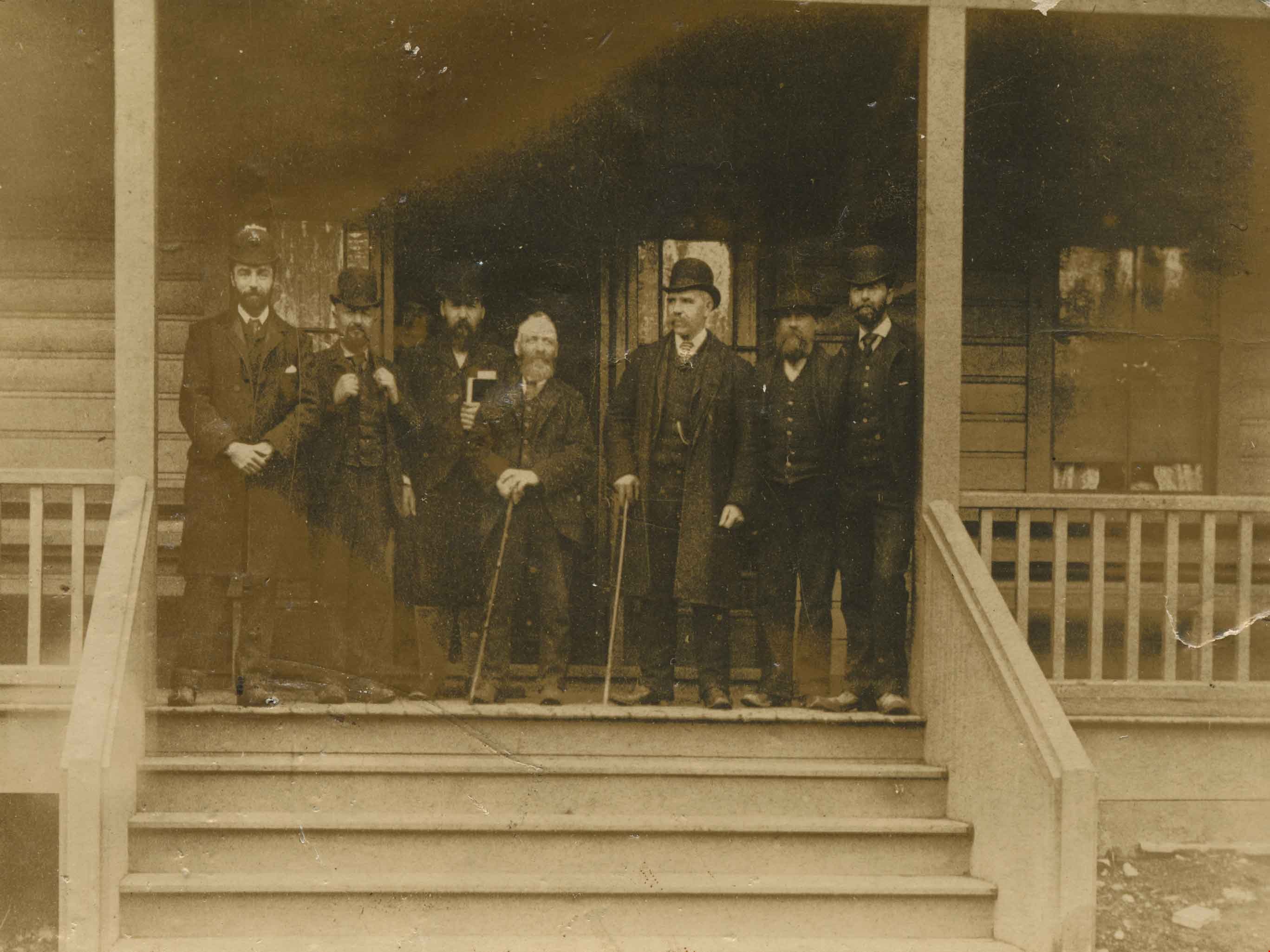
- Photograph of Burnaby's first Council members on the steps of Sample's Boarding House, 6850 Beresford Street, near Griffiths Avenue and Kingsway. Left to right: L.C. Hill, William Brenchley, Alex Philip (clerk), Charles R. Shaw (Reeve), William McDermott, John Woolard, and Arthur de Windt Haszard.
- Repository
- City of Burnaby Archives
- Date
- 1892
- Collection/Fonds
- Burnaby Historical Society fonds
- Subseries
- Photographs subseries
- Physical Description
- 1 photograph : sepia postcard ; 9 x 11.5 cm
- Description Level
- Item
- Record No.
- 008-001
- Access Restriction
- No restrictions
- Reproduction Restriction
- No known restrictions
- Accession Number
- BHS2007-04
- Scope and Content
- Photograph of Burnaby's first Council members on the steps of Sample's Boarding House, 6850 Beresford Street, near Griffiths Avenue and Kingsway. Left to right: L.C. Hill, William Brenchley, Alex Philip (clerk), Charles R. Shaw (Reeve), William McDermott, John Woolard, and Arthur de Windt Haszard.
- Names
- Brenchley, William
- Haszard, Arthur de Windt
- Hill, Louis Claude "Claude"
- McDermott, William
- Philip, Alex
- Shaw, Charles R. "Chas"
- Woolard, John
- Media Type
- Photograph
- Notes
- Title based on contents of photograph
- Geographic Access
- Beresford Street
- Street Address
- 6850 Beresford Street
- Historic Neighbourhood
- Edmonds (Historic Neighbourhood)
- Planning Study Area
- Kingsway-Beresford Area
Images

Edison Road Power House
https://search.heritageburnaby.ca/link/archivedescription36086
- Repository
- City of Burnaby Archives
- Date
- 1893 (date of original), copied November 26, 1975
- Collection/Fonds
- Burnaby Historical Society fonds
- Description Level
- Item
- Physical Description
- 1 photograph : b&w ; 10.5 x 14 cm print
- Scope and Content
- Photograph of the Edison Road Power House, of the Westminster and Vancouver Tramway Co. Ltd., the first electric interurban street railway in North America. This power house stood between Vancouver Road (Kingsway) and the line to Vancouver. (Edison Road is now Griffiths Avenue).
- Repository
- City of Burnaby Archives
- Date
- 1893 (date of original), copied November 26, 1975
- Collection/Fonds
- Burnaby Historical Society fonds
- Subseries
- Columbian Newspaper subseries
- Physical Description
- 1 photograph : b&w ; 10.5 x 14 cm print
- Description Level
- Item
- Record No.
- 222-009
- Access Restriction
- No restrictions
- Reproduction Restriction
- No known restrictions
- Accession Number
- BHS1989-19
- Scope and Content
- Photograph of the Edison Road Power House, of the Westminster and Vancouver Tramway Co. Ltd., the first electric interurban street railway in North America. This power house stood between Vancouver Road (Kingsway) and the line to Vancouver. (Edison Road is now Griffiths Avenue).
- Media Type
- Photograph
- Notes
- Title based on contents of photograph
- Geographic Access
- Griffiths Avenue
- Kingsway
- Historic Neighbourhood
- Edmonds (Historic Neighbourhood)
- Planning Study Area
- Kingsway-Beresford Area
Images

Gilley Brothers Logging team
https://search.heritageburnaby.ca/link/archivedescription38561
- Repository
- City of Burnaby Archives
- Date
- [1895]
- Collection/Fonds
- Burnaby Historical Society fonds
- Description Level
- Item
- Physical Description
- 1 photograph : b&w ; 28 x 35.2 cm
- Scope and Content
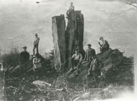
- Photograph of a team of horses crossing a plank bridge with cleared trees and forest in the background.
- Repository
- City of Burnaby Archives
- Date
- [1895]
- Collection/Fonds
- Burnaby Historical Society fonds
- Subseries
- Photographs subseries
- Physical Description
- 1 photograph : b&w ; 28 x 35.2 cm
- Description Level
- Item
- Record No.
- 461-003
- Access Restriction
- No restrictions
- Reproduction Restriction
- No known restrictions
- Accession Number
- BHS2007-04
- Scope and Content
- Photograph of a team of horses crossing a plank bridge with cleared trees and forest in the background.
- Media Type
- Photograph
- Notes
- Title based on contents of photograph
- A note on the back of item no. 379-001 (the copy print to this original reads: "Logging operation at Kingsway and Gilley Avenue carried on by Gilley Brothers before the turn of the century."
- Geographic Access
- Kingsway
- Gilley Avenue
- Historic Neighbourhood
- Edmonds (Historic Neighbourhood)
- Planning Study Area
- Kingsway-Beresford Area
Images
![Gilley Brothers Logging Camp, [1900] thumbnail](/media/hpo/_Data/_Archives_Images/_Unrestricted/371/461-001.jpg?width=280)
Gilley Brothers Logging Camp
https://search.heritageburnaby.ca/link/archivedescription38559
- Repository
- City of Burnaby Archives
- Date
- [1900]
- Collection/Fonds
- Burnaby Historical Society fonds
- Description Level
- Item
- Physical Description
- 1 photograph : b&w : 28 x 35.5 cm
- Scope and Content
- Photograph of a large group of workmen posing for a picture outside the Gilley Bros. logging camp at Imperial and Colborne. All are unidentified.
- Repository
- City of Burnaby Archives
- Date
- [1900]
- Collection/Fonds
- Burnaby Historical Society fonds
- Subseries
- Photographs subseries
- Physical Description
- 1 photograph : b&w : 28 x 35.5 cm
- Description Level
- Item
- Record No.
- 461-001
- Access Restriction
- No restrictions
- Reproduction Restriction
- No known restrictions
- Accession Number
- BHS2007-04
- Scope and Content
- Photograph of a large group of workmen posing for a picture outside the Gilley Bros. logging camp at Imperial and Colborne. All are unidentified.
- Subjects
- Buildings - Residential - Cabins
- Industries - Forestry
- Occupations - Lumberjacks
- Industries - Logging/lumber
- Media Type
- Photograph
- Notes
- Title based on contents of photograph
- Geographic Access
- Imperial Street
- Colborne Avenue
- Historic Neighbourhood
- Edmonds (Historic Neighbourhood)
- Planning Study Area
- Kingsway-Beresford Area
Images
![Gilley Brothers Logging Camp, [1900] thumbnail](/media/hpo/_Data/_Archives_Images/_Unrestricted/371/461-001.jpg)

Murdock and Lillian McMurray interview November 17, 1975 - Track 2
https://search.heritageburnaby.ca/link/oralhistory244
- Repository
- City of Burnaby Archives
- Date Range
- 1906-1975
- Length
- 0:09:00
- Summary
- This portion of the recording pertains to Murdock McMurray's memories of riding the tram as a young man and briefly, of working for Ed Brown. Murdock mentions Reeve Byrne and the development of first water system in Burnaby. He also discusses Gilley Brother's Logging Company practices near his fath…
- Repository
- City of Burnaby Archives
- Summary
- This portion of the recording pertains to Murdock McMurray's memories of riding the tram as a young man and briefly, of working for Ed Brown. Murdock mentions Reeve Byrne and the development of first water system in Burnaby. He also discusses Gilley Brother's Logging Company practices near his father's ranch of six acres, which grew mostly strawberries to sell in Vancouver.
- Date Range
- 1906-1975
- Photo Info
- Emerson Doran (left) and Murdoch McMurray, 1917. Item no. 229-004
- Length
- 0:09:00
- Subjects
- Agriculture - Fruit and Berries
- Geographic Access
- Imperial Street
- Historic Neighbourhood
- Edmonds (Historic Neighbourhood)
- Planning Study Area
- Kingsway-Beresford Area
- Interviewer
- McGeachie, Doreen “Pixie”
- Interview Date
- November 17, 1975
- Scope and Content
- Recording is of an interview with Murdock McMurray and his wife Lillian (Wray) McMurray conducted by Pixie McGeachie on November 17, 1975. Major themes discussed are: Burnaby's development, the Wray Shoe store and Murdock McMurray's cordwood delivery business.
- Biographical Notes
- Murdock McMurray was born in Vancouver in 1892 to Wilhelmina May and Robert William McMurray. Other children in the family included older siblings John “Jack” and Margaret Lillian, younger siblings Minnie May born May 4, 1895 and Hampton born June 8, 1902. Murdock’s father Robert worked for the Canadian Pacific Railway (CPR) but retired shortly after moving his family to Burnaby in 1906. He bought six acres of land of what had been previously the Gilley Ranch, the base of operations for Gilley Bros. Ltd. at 2519 Windsor Street (later renumbered and renamed to the 6400 block Imperial Street). Murdock McMurray quit school early to apprentice as a printer. By sixteen he had left the trade and gone into partnership with his older brother Jack. With a team of horses, harness and a wagon, the brothers helped to macadamize roads, haul building supplies for new homes, deliver cord wood for heating, clear land and excavate basements. When Jack McMurray set off to serve overseas during World War I as a driver in the engineer corps, Murdock bought his team of horses and continued working, mainly in the Deer Lake district. In 1916 Murdoch McMurray partnered with Emerson Doran, nephew of the owner of Doran's Mill to buy Edmonds Coal and Wood fuel yard. As everything was geared towards the war effort, Murdock and Emerson soon ran out of work and had to sell the business. Murdock sold off his horses and equipment and went to work at the ship yard on Pitt River. By 1919 Jack McMurray had returned home from overseas and was working as a fireman at the Shull Lumber and Shingle Mill on the Fraser River. In 1921, he and Murdock teamed up with Emerson Doran and repurchased the Edmonds Coal and Wood fuel yard which they ran together until 1947. Murdock McMurray married Lillian Wray on September 17, 1925. Lillian was the daughter of Mr. and Mrs. Edward Wray, who came to settle in the Jubilee area of Burnaby in 1919. The family lived on Dow Road and Edward Wray operated Jubilee Shoe Store and Post Office. He was known throughout the district as "Wray - The Shoe Man." Mrs. Wray died in 1957 at the age of eight-six and Edward Wray died January 14, 1967 at age of ninety-three. Murdock and Lillian lived at Inverness Street (now Arcola) and raised three children together, Bob, Jack and Bessie. Murdock McMurray died in New Westminster on April 28, 1985 at the age of ninety-two. Lillian Ethel (Wray) McMurray died in Burnaby on February 28, 1986 at the age of eighty-seven.
- Total Tracks
- 7
- Total Length
- 0:58:55
- Interviewee Name
- McMurray, Lillian Wray
- McMurray, Murdoch
- Interviewer Bio
- Doreen "Pixie" (Johnson) McGeachie was a resident of Burnaby for over sixty years. Pixie married John Aloysius "Jack" McGeachie and raised their children Kathi (Dunlop) and David McGeachie in the house the couple built themselves in 1947. Pixie served as the editor for the Burnaby Examiner newspaper and wrote a column entitled "Burnaby History" for The News. In 1974 she authored her first book titled "Bygones of Burnaby" which was one of the first to develop anecdotal stories about pioneer life in Burnaby. She authored "Burnaby - A Proud Century" in 1992 and in 2002 she wrote a biography of the city's namesake in the book "Land of Promise: Robert Burnaby's letters from Colonial B.C." She also contributed many hours of volunteering; helping to establish Burnaby's first museum Heritage Village in 1971, serving as President of the Burnaby Historical Society from 1991-1993. She served a six year term on Burnaby's Heritage Commission leading the charge to preserve many historic sites throughout the city, and during her twenty years as the Community Archives volunteer archivist for the historical society, she succeeded in gathering thousands of rare and valuable historic photographs and documents which now forms the core of the photograph collection on the Heritage Burnaby website (as these items were donated by the Society to the City Archives in 2007). The City of Burnaby awarded Pixie McGeachie the Kushiro Cup as Citizen of the year in 2002. In 2006 she received a Heritage BC project award for leading the Friends of Interurban 1223 project, and in 2008 Heritage BC recognised her again by presenting her with the Ruby Nobb Award. John Aloysius "Jack" McGeachie died October 12, 1981 at the age of sixty-seven. Doreen "Pixie" (Johnson) McGeachie died August 14, 2010 at the age of eighty-nine. On 24 September, 2011, the City of Burnaby dedicated the reading at the City Archives in honour of Pixie and formally named it the Pixie McGeachie Reading Room in recognition of her years of service to the community.
- Collection/Fonds
- Burnaby Historical Society fonds
- Subseries
- Oral history subseries
- Media Type
- Sound Recording
- Web Notes
- Interview was digitized in 2010 allowing it to be accessible on Heritage Burnaby. The digitization project was initiated by the Community Heritage Commission with support from City of Burnaby Council and the BC History Digitization Program of the Irving K. Barber Learning Centre, University of British Columbia. It was recognized by the Heritage Society of BC with an award in 2012.
Images

Audio Tracks
Track two of recording of interview with Lillian and Murdock McMurray
Track two of recording of interview with Lillian and Murdock McMurray
https://search.heritageburnaby.ca/media/hpo/_Data/_Archives_Oral_Histories/_Unrestricted/MSS137-010/MSS137-010_Track_2.mp3
Jacob & Margaret Wysong House
https://search.heritageburnaby.ca/link/landmark507
- Repository
- Burnaby Heritage Planning
- Description
- The Jacob and Margaret Wysong House is a two and one-half storey, wood-frame Arts and Crafts house with a hipped roof and hipped dormers. Symmetrical in massing, it is distinguished by its masonry verandah columns, foundations and chimneys. It is located on a corner lot on Sperling Avenue at Stanle…
- Associated Dates
- 1912
- Formal Recognition
- Heritage Designation, Community Heritage Register
- Street View URL
- Google Maps Street View
- Repository
- Burnaby Heritage Planning
- Geographic Access
- Sperling Avenue
- Associated Dates
- 1912
- Formal Recognition
- Heritage Designation, Community Heritage Register
- Enactment Type
- By-law No. 11978
- Enactment Date
- 17/10/2005
- Description
- The Jacob and Margaret Wysong House is a two and one-half storey, wood-frame Arts and Crafts house with a hipped roof and hipped dormers. Symmetrical in massing, it is distinguished by its masonry verandah columns, foundations and chimneys. It is located on a corner lot on Sperling Avenue at Stanley Street in the Edmonds neighbourhood of South Burnaby.
- Heritage Value
- The Jacob and Margaret Wysong House is significant for illustrating the early development of the Edmonds neighbourhood, a speculative subdivision that was created and marketed during the pre-First World War real estate boom. The area’s proximity to New Westminster, coupled with extensive views and two newly developed streetcar lines, ensured that Edmonds attracted a wave of suburban development. The scale of this house is atypical of the usual suburban lots, and reflects the prominence of this location and its spectacular views. Set on a large lot, the Jacob and Margaret Wysong House is a grand estate home that is one of the earliest, and most prominent, in South Burnaby. This is also an exceptional example of Arts and Crafts architecture, displaying the use of native materials that was a hallmark of the style. The first owners were Jacob Wysong and his wife Margaret. Jacob Wysong, a local contractor, constructed the house in 1912. The stonework is exceptional, and the use of rough-cut granite and fieldstone, with overall shingle cladding, recalls the rustic vernacular common in Western park lodges, and evokes a country lifestyle in harmony with nature. The hipped roof was designed with a flat top that acted as a lookout tower that provided views of the surrounding landscape.
- Defining Elements
- Key elements that define the heritage character of the Jacob and Margaret Wysong House include its: - prominent corner location in the Edmonds neighbourhood of South Burnaby - residential form, scale and massing as expressed by its two and one-half storey plus raised basement height, symmetrical plan, hipped roof with flat top, hipped dormers, and hipped roof over the full open front verandah with a central front gable - masonry elements such as rough-cut granite and fieldstone foundations, verandah columns, stair cheeks, and external and internal chimneys - wooden-frame construction including original cedar shingling on dormers and facing verandah, shingling on remainder of house under later stucco cladding, and surviving original dimensional trim facing verandah and on dormers - Arts and Crafts features such as the use of natural materials, open soffits and angled roof overhang - windows including: double-hung 18-over-1 wooden sash windows; multi-paned casement windows; French doors to verandah; and front door with glazed sidelights - associated landscape features including surrounding mature trees, hedges and perimeter plantings
- Historic Neighbourhood
- Edmonds (Historic Neighbourhood)
- Planning Study Area
- Kingsway-Beresford Area
- Function
- Primary Historic--Single Dwelling
- Primary Current--Single Dwelling
- Community
- Edmonds
- Cadastral Identifier
- P.I.D. 000-497-801
- Boundaries
- The Jacob and Margaret Wysong House is comprised of a single residential lot located at 6325 Sperling Avenue, Burnaby.
- Area
- 1087.62
- Contributing Resource
- Building
- Ownership
- Private
- Documentation
- City of Burnaby Planning and Building Department, Heritage Site Files
- Street Address
- 6325 Sperling Avenue
- Street View URL
- Google Maps Street View
Images


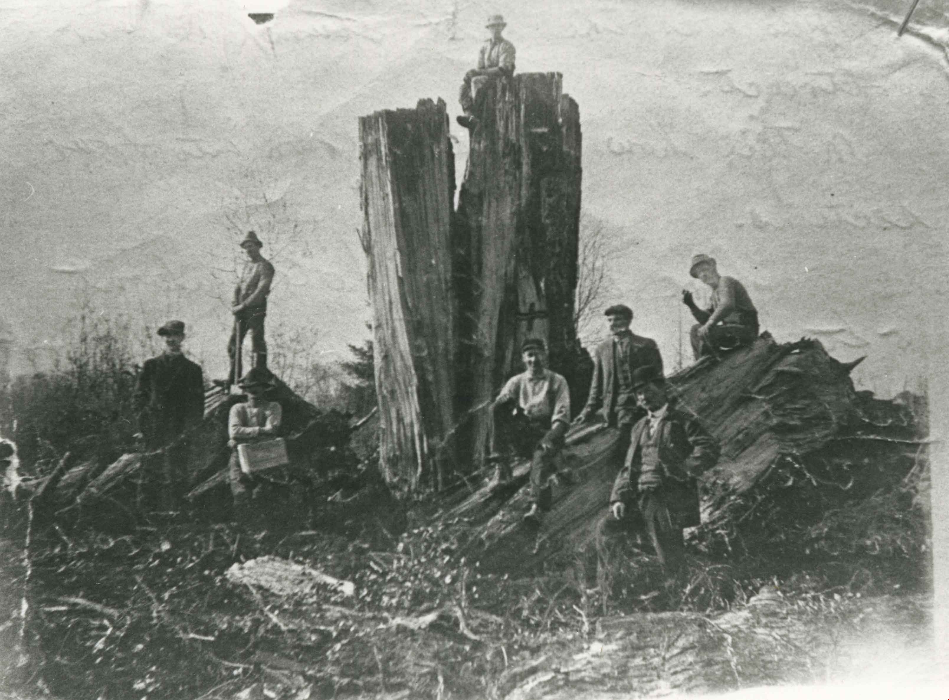
William Walker and his crew
https://search.heritageburnaby.ca/link/archivedescription35368
- Repository
- City of Burnaby Archives
- Date
- 1913 (date of original), copied 1986
- Collection/Fonds
- Burnaby Historical Society fonds
- Description Level
- Item
- Physical Description
- 1 photograph : b&w ; 12.7 x 17.8 cm print
- Scope and Content
- Photograph of William Walker, a member of a crew contracted by the municipality to clear the area between Colborne Avenue, Brantford Avenue and Imperial Street in South Burnaby The land was cleared by blasting. The tree in this picture measured 24 feet in circumference.
- Repository
- City of Burnaby Archives
- Date
- 1913 (date of original), copied 1986
- Collection/Fonds
- Burnaby Historical Society fonds
- Subseries
- Pioneer Tales subseries
- Physical Description
- 1 photograph : b&w ; 12.7 x 17.8 cm print
- Description Level
- Item
- Record No.
- 204-225
- Access Restriction
- No restrictions
- Reproduction Restriction
- No known restrictions
- Accession Number
- BHS1988-03
- Scope and Content
- Photograph of William Walker, a member of a crew contracted by the municipality to clear the area between Colborne Avenue, Brantford Avenue and Imperial Street in South Burnaby The land was cleared by blasting. The tree in this picture measured 24 feet in circumference.
- Subjects
- Land Clearing
- Plants - Trees
- Names
- Walker, William
- Media Type
- Photograph
- Notes
- Title based on contents of photograph
- Historic Neighbourhood
- Edmonds (Historic Neighbourhood)
- Planning Study Area
- Kingsway-Beresford Area
Images
![Land Clearing, [1913] (date of original), copied 1986 thumbnail](/media/hpo/_Data/_Archives_Images/_Unrestricted/204/204-226.jpg?width=280)
Land Clearing
https://search.heritageburnaby.ca/link/archivedescription35369
- Repository
- City of Burnaby Archives
- Date
- [1913] (date of original), copied 1986
- Collection/Fonds
- Burnaby Historical Society fonds
- Description Level
- Item
- Physical Description
- 1 photograph : b&w ; 12.7 x 17.8 cm print
- Scope and Content
- Photograph of land clearing by a crew contracted by the municipality to clear the area between Colborne Avenue, Brantford Avenue and Imperial Street in South Burnaby. William Walker was a member of this crew. The land was cleared by blasting.
- Repository
- City of Burnaby Archives
- Date
- [1913] (date of original), copied 1986
- Collection/Fonds
- Burnaby Historical Society fonds
- Subseries
- Pioneer Tales subseries
- Physical Description
- 1 photograph : b&w ; 12.7 x 17.8 cm print
- Description Level
- Item
- Record No.
- 204-226
- Access Restriction
- No restrictions
- Reproduction Restriction
- No known restrictions
- Accession Number
- BHS1988-03
- Scope and Content
- Photograph of land clearing by a crew contracted by the municipality to clear the area between Colborne Avenue, Brantford Avenue and Imperial Street in South Burnaby. William Walker was a member of this crew. The land was cleared by blasting.
- Subjects
- Land Clearing
- Media Type
- Photograph
- Notes
- Title based on contents of photograph
- Historic Neighbourhood
- Edmonds (Historic Neighbourhood)
- Planning Study Area
- Kingsway-Beresford Area
Images
![Land Clearing, [1913] (date of original), copied 1986 thumbnail](/media/hpo/_Data/_Archives_Images/_Unrestricted/204/204-226.jpg)

Kingsway East School
https://search.heritageburnaby.ca/link/landmark546
- Repository
- Burnaby Heritage Planning
- Description
- The Kingsway East School is a two-storey wood-frame Arts and Crafts styled building. The school, and the adjacent cenotaph and memorial tennis courts, comprise Burnaby South Memorial Park.
- Associated Dates
- 1913
- Formal Recognition
- Heritage Designation, Community Heritage Register
- Other Names
- Alan Emmott Centre
- Street View URL
- Google Maps Street View
- Repository
- Burnaby Heritage Planning
- Other Names
- Alan Emmott Centre
- Geographic Access
- Southoaks Crescent
- Associated Dates
- 1913
- Formal Recognition
- Heritage Designation, Community Heritage Register
- Enactment Type
- Bylaw No. 9807
- Enactment Date
- 23/11/1992
- Description
- The Kingsway East School is a two-storey wood-frame Arts and Crafts styled building. The school, and the adjacent cenotaph and memorial tennis courts, comprise Burnaby South Memorial Park.
- Heritage Value
- This school structure completed in 1913, the oldest surviving public education building in the city, was intended to be the auditorium and gymnasium for Burnaby’s first high school. However, because of the 1913 recession and the outbreak of the First World War, it was utilized as the Kingsway East Elementary School for the Edmonds District until 1921. Burnaby South High School opened here in 1922, and after it relocated this building was used for a variety of school purposes until it became redundant. The school was rehabilitated for community purposes in 2002-03 and renamed the Alan Emmott Centre to honor a former Mayor of Burnaby. The impressive scale of the Kingsway East School is indicative of the relative size of the community and its growing demand for schooling at the time of construction, illustrating the value that early community residents placed on education. Built to plans of the Burnaby School Board architect, Joseph Henry Bowman (1864-1943), it also indicates the individual values and design control exercised by the school board during this era. It is also significant for its Arts and Crafts style, allied to the typical Craftsman residential vocabulary, which was employed locally for school buildings of the Edwardian era. By using a common architectural vocabulary, this allowed the institution to reflect the values and aspirations of the local community. The Arts and Crafts style also demonstrated an allegiance to British educational antecedents and a demonstration of loyalty to the Mother Country.
- Historic Neighbourhood
- Edmonds (Historic Neighbourhood)
- Planning Study Area
- Kingsway-Beresford Area
- Function
- Primary Historic--Primary School
- Community
- Burnaby
- Cadastral Identifier
- P.I.D. No. 016-367-154 Legal Description: Lot 1, District Lot 96, Group 1 New Westminster District, Plan 86581
- Boundaries
- The Kingsway East School is comprised of a single municipally-owned property located at 6650 Southoaks Crescent, Burnaby.
- Area
- 6,070.00
- Contributing Resource
- Building
- Landscape Feature
- Structure
- Ownership
- Public (local)
- Documentation
- Heritage Site Files: PC77000 20. City of Burnaby Planning and Building Department, 4949 Canada Way, Burnaby, B.C., V5G 1M2
- Street Address
- 6650 Southoaks Crescent
- Street View URL
- Google Maps Street View
Images


Kingsway
https://search.heritageburnaby.ca/link/landmark775
- Repository
- Burnaby Heritage Planning
- Associated Dates
- 1913
- Heritage Value
- The years 1911-1912 saw great expansion and settlement in Burnaby and large public works projects were undertaken to service the growing community. One project that was determined to be a necessity was the construction of a proper highway between New Westminster and Vancouver. The Province and the Municipality agreed to share the costs of construction (with Burnaby paying 25% and the Province 75%) and so Kingsway was built to improve the current Vancouver Road. The road was named after the famous King's Way in London, England.
- Historic Neighbourhood
- Central Park (Historic Neighbourhood)
- Edmonds (Historic Neighbourhood)
- Planning Study Area
- Maywood Area
- Marlborough Area
- Windsor Area
- Kingsway-Beresford Area
- Stride Avenue Area
- Edmonds Area
Images

![Kingsway East School, [between 1914 and 1919] thumbnail](/media/hpo/_Data/_Archives_Images/_Unrestricted/316/325-028.jpg?width=280)
Kingsway East School
https://search.heritageburnaby.ca/link/archivedescription37156
- Repository
- City of Burnaby Archives
- Date
- [between 1914 and 1919]
- Collection/Fonds
- Burnaby Historical Society fonds
- Description Level
- Item
- Physical Description
- 1 photograph : b&w ; 8.5 x 12.5 cm print
- Scope and Content
- Photograph of the front entrance and side yard at Kingsway East School.
- Repository
- City of Burnaby Archives
- Date
- [between 1914 and 1919]
- Collection/Fonds
- Burnaby Historical Society fonds
- Subseries
- Disney family subseries
- Physical Description
- 1 photograph : b&w ; 8.5 x 12.5 cm print
- Description Level
- Item
- Record No.
- 325-028
- Access Restriction
- No restrictions
- Reproduction Restriction
- No known restrictions
- Accession Number
- BHS1996-04
- Scope and Content
- Photograph of the front entrance and side yard at Kingsway East School.
- Subjects
- Buildings - Schools
- Names
- Kingsway East School
- Media Type
- Photograph
- Photographer
- Disney, John Harold "Jack"
- Notes
- Title based on contents of photograph
- Geographic Access
- Kingsway
- Mission Avenue
- Street Address
- 6650 Southoaks Crescent
- Historic Neighbourhood
- Edmonds (Historic Neighbourhood)
- Planning Study Area
- Kingsway-Beresford Area
Images
![Kingsway East School, [between 1914 and 1919] thumbnail](/media/hpo/_Data/_Archives_Images/_Unrestricted/316/325-028.jpg)
![Back of Kingsway East School, [between 1914 and 1919] thumbnail](/media/hpo/_Data/_Archives_Images/_Unrestricted/316/325-029.jpg?width=280)
Back of Kingsway East School
https://search.heritageburnaby.ca/link/archivedescription37157
- Repository
- City of Burnaby Archives
- Date
- [between 1914 and 1919]
- Collection/Fonds
- Burnaby Historical Society fonds
- Description Level
- Item
- Physical Description
- 1 photograph : b&w ; 8 x 12.5 cm print
- Scope and Content
- Photograph of the back of Kingsway East School and surrounding fields.
- Repository
- City of Burnaby Archives
- Date
- [between 1914 and 1919]
- Collection/Fonds
- Burnaby Historical Society fonds
- Subseries
- Disney family subseries
- Physical Description
- 1 photograph : b&w ; 8 x 12.5 cm print
- Description Level
- Item
- Record No.
- 325-029
- Access Restriction
- No restrictions
- Reproduction Restriction
- No known restrictions
- Accession Number
- BHS1996-04
- Scope and Content
- Photograph of the back of Kingsway East School and surrounding fields.
- Subjects
- Buildings - Schools
- Names
- Kingsway East School
- Media Type
- Photograph
- Photographer
- Disney, John Harold "Jack"
- Notes
- Title based on contents of photograph
- Geographic Access
- Kingsway
- Mission Avenue
- Street Address
- 6650 Southoaks Crescent
- Historic Neighbourhood
- Edmonds (Historic Neighbourhood)
- Planning Study Area
- Kingsway-Beresford Area
Images
![Back of Kingsway East School, [between 1914 and 1919] thumbnail](/media/hpo/_Data/_Archives_Images/_Unrestricted/316/325-029.jpg)
![Men riding bicycles, [1914] thumbnail](/media/hpo/_Data/_BVM_Images/1971/197200110015.jpg?width=280)
Men riding bicycles
https://search.heritageburnaby.ca/link/museumdescription3101
- Repository
- Burnaby Village Museum
- Date
- [1914]
- Collection/Fonds
- Burnaby Village Museum Photograph collection
- Description Level
- Item
- Physical Description
- 1 photograph : b&w glass negative ; 16.4 x 21.3 cm
- Scope and Content
- Photograph of a paved road lined with electric poles on both sides and a wood plank sidewalk on one side of the road. There are two men in suits and bowler hats riding bicycles and another man in suit and bowler hat standing on the sidewalk. The sun is casting long shadows from the left side of the…
- Repository
- Burnaby Village Museum
- Collection/Fonds
- Burnaby Village Museum Photograph collection
- Description Level
- Item
- Physical Description
- 1 photograph : b&w glass negative ; 16.4 x 21.3 cm
- Scope and Content
- Photograph of a paved road lined with electric poles on both sides and a wood plank sidewalk on one side of the road. There are two men in suits and bowler hats riding bicycles and another man in suit and bowler hat standing on the sidewalk. The sun is casting long shadows from the left side of the photograph. An earlier catalogue record from 1988 conjectures that the photograph may be of Kingsway in Burnaby, possibly near Gilley looking east towards Griffiths Avenue. The record also dates the negative, ca. 1914.
- Geographic Access
- Kingsway
- Griffiths Avenue
- Accession Code
- HV972.11.15
- Access Restriction
- No restrictions
- Reproduction Restriction
- No known restrictions
- Date
- [1914]
- Media Type
- Photograph
- Historic Neighbourhood
- Edmonds (Historic Neighbourhood)
- Planning Study Area
- Kingsway-Beresford Area
- Scan Resolution
- 300
- Scan Date
- 14/8/2006
- Scale
- 100
- Notes
- Title based on contents of photograph
- 1 b&w contact print accompanying negative
Images
![Men riding bicycles, [1914] thumbnail](/media/hpo/_Data/_BVM_Images/1971/197200110015.jpg)

Kingsway East School
https://search.heritageburnaby.ca/link/museumdescription11121
- Repository
- Burnaby Village Museum
- Date
- April 27, 1915
- Collection/Fonds
- Ronald G. Scobbie collection
- Description Level
- Item
- Physical Description
- 1 survey plan : blueprint on paper ; 56 x 54 cm
- Scope and Content
- Survey plan of "Kingsway East School Site" "Burnaby Municipality" / "Lot 10, of the Subdivision of Lot "D" of... Lot 96, Group 1, New Westminster District"
- Repository
- Burnaby Village Museum
- Collection/Fonds
- Ronald G. Scobbie collection
- Description Level
- Item
- Physical Description
- 1 survey plan : blueprint on paper ; 56 x 54 cm
- Material Details
- Scale: 40 feet = 1 inch
- Scope and Content
- Survey plan of "Kingsway East School Site" "Burnaby Municipality" / "Lot 10, of the Subdivision of Lot "D" of... Lot 96, Group 1, New Westminster District"
- Subjects
- Buildings - Schools
- Names
- Kingsway East School
- Geographic Access
- Kingsway
- Mission Avenue
- Street Address
- 6650 Southoaks Crescent
- Accession Code
- BV003.83.1
- Access Restriction
- No restrictions
- Reproduction Restriction
- No known restrictions
- Date
- April 27, 1915
- Media Type
- Cartographic Material
- Historic Neighbourhood
- Edmonds (Historic Neighbourhood)
- Planning Study Area
- Kingsway-Beresford Area
- Scan Resolution
- 440
- Scan Date
- 22-Dec-2020
- Scale
- 100
- Notes
- Title based on contents of plan
- handwritten on back, "1753"
- signed "Geoffrey Burnett"; notarized, signature illegible
- "Oath of I, Geoffrey K. Burnett...did personally superintend the survey..." "Survey was completed on the 27th day of April 1915.
Zoomable Images

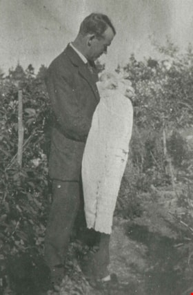
Urquhart family
https://search.heritageburnaby.ca/link/archivedescription35284
- Repository
- City of Burnaby Archives
- Date
- 1919 (date of original), copied 1986
- Collection/Fonds
- Burnaby Historical Society fonds
- Description Level
- Item
- Physical Description
- 1 photograph : b&w ; 12.7 x 17.8 cm print
- Scope and Content
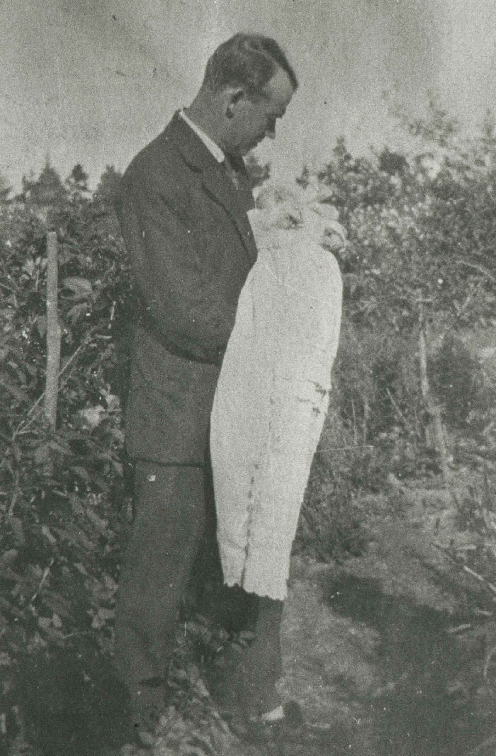
- Photograph of William Urquhart with baby daughter, Peggy Urquhart (Margaret Urquhart, later Margaret Frederick). The photograph was taken on the Urquhart property. The house was previously numbered 2674, then changed to 6625, and later 6637 Griffiths Avenue.
- Repository
- City of Burnaby Archives
- Date
- 1919 (date of original), copied 1986
- Collection/Fonds
- Burnaby Historical Society fonds
- Subseries
- Pioneer Tales subseries
- Physical Description
- 1 photograph : b&w ; 12.7 x 17.8 cm print
- Description Level
- Item
- Record No.
- 204-141
- Access Restriction
- No restrictions
- Reproduction Restriction
- No known restrictions
- Accession Number
- BHS1988-03
- Scope and Content
- Photograph of William Urquhart with baby daughter, Peggy Urquhart (Margaret Urquhart, later Margaret Frederick). The photograph was taken on the Urquhart property. The house was previously numbered 2674, then changed to 6625, and later 6637 Griffiths Avenue.
- Media Type
- Photograph
- Notes
- Title based on contents of photograph
- Geographic Access
- Griffiths Avenue
- Street Address
- 6637 Griffiths Avenue
- Historic Neighbourhood
- Edmonds (Historic Neighbourhood)
- Planning Study Area
- Kingsway-Beresford Area
Images