Narrow Results By
Subject
- Accidents 1
- Advertising Medium - Signs and Signboards 3
- Aerial Photographs 2
- Agriculture - Farms 1
- Arts 1
- Arts - Paintings 2
- Building Components 1
- Buildings 2
- Buildings - Agricultural - Greenhouses 1
- Buildings - Agricultural - Nurseries 2
- Buildings - Civic - City Halls 1
- Buildings - Civic - Seniors Centres 2
![St. Thomas More Collegiate football practice, [2000] thumbnail](/media/hpo/_Data/_Archives_Images/_Unrestricted/535/535-2703.jpg?width=280)
St. Thomas More Collegiate football practice
https://search.heritageburnaby.ca/link/archivedescription97307
- Repository
- City of Burnaby Archives
- Date
- [2000]
- Collection/Fonds
- Burnaby NewsLeader photograph collection
- Description Level
- Item
- Physical Description
- 1 photograph (tiff) : col.
- Scope and Content
- Photograph of two unidentified members of St. Thomas More Collegiate's senior football team during a practice.
- Repository
- City of Burnaby Archives
- Date
- [2000]
- Collection/Fonds
- Burnaby NewsLeader photograph collection
- Physical Description
- 1 photograph (tiff) : col.
- Description Level
- Item
- Record No.
- 535-2703
- Access Restriction
- No restrictions
- Reproduction Restriction
- No restrictions
- Accession Number
- 2018-12
- Scope and Content
- Photograph of two unidentified members of St. Thomas More Collegiate's senior football team during a practice.
- Subjects
- Persons - Students
- Sports - Football
- Media Type
- Photograph
- Photographer
- Bartel, Mario
- Notes
- Title based on caption
- Collected by editorial for use in a September 2000 issue of the Burnaby NewsLeader
- Caption from metadata: "St. Thomas Moore's senior football team will be counting the size and experience of its returning linemen."
- Geographic Access
- 12th Avenue
- Street Address
- 7450 12th Avenue
- Historic Neighbourhood
- Edmonds (Historic Neighbourhood)
- Planning Study Area
- Edmonds Area
Images
![St. Thomas More Collegiate football practice, [2000] thumbnail](/media/hpo/_Data/_Archives_Images/_Unrestricted/535/535-2703.jpg)
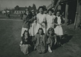
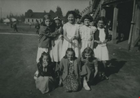
Students at Edmonds
https://search.heritageburnaby.ca/link/archivedescription35963
- Repository
- City of Burnaby Archives
- Date
- 1944
- Collection/Fonds
- Burnaby Historical Society fonds
- Description Level
- Item
- Physical Description
- 1 photograph : b&w ; 5.5 x 7.5 cm print
- Scope and Content
- Photograph of a group of school-aged of girls, standing near the rear of the main building at Edmonds Street School.
- Repository
- City of Burnaby Archives
- Date
- 1944
- Collection/Fonds
- Burnaby Historical Society fonds
- Subseries
- Edmonds School subseries
- Physical Description
- 1 photograph : b&w ; 5.5 x 7.5 cm print
- Description Level
- Item
- Record No.
- 207-012
- Access Restriction
- No restrictions
- Reproduction Restriction
- No known restrictions
- Accession Number
- BHS1988-07
- Scope and Content
- Photograph of a group of school-aged of girls, standing near the rear of the main building at Edmonds Street School.
- Names
- Edmonds Community School
- Media Type
- Photograph
- Notes
- Title based on contents of photograph
- Geographic Access
- 18th Avenue
- Street Address
- 7651 18th Avenue
- Historic Neighbourhood
- Edmonds (Historic Neighbourhood)
- Planning Study Area
- Edmonds Area
Images
![Student with Edmonds Town Centre banner, [2002] thumbnail](/media/hpo/_Data/_Archives_Images/_Unrestricted/535/535-2915.jpg?width=280)
Student with Edmonds Town Centre banner
https://search.heritageburnaby.ca/link/archivedescription97599
- Repository
- City of Burnaby Archives
- Date
- [2002]
- Collection/Fonds
- Burnaby NewsLeader photograph collection
- Description Level
- Item
- Physical Description
- 1 photograph (tiff) : col.
- Scope and Content
- Photograph of Anthony Lazazzera, a grade three student at St. Francis de Sales School, posing with a banner he designed. The banner reads: "Edmonds Town Centre" and features a drawing of a sunflower.
- Repository
- City of Burnaby Archives
- Date
- [2002]
- Collection/Fonds
- Burnaby NewsLeader photograph collection
- Physical Description
- 1 photograph (tiff) : col.
- Description Level
- Item
- Record No.
- 535-2915
- Access Restriction
- No restrictions
- Reproduction Restriction
- No restrictions
- Accession Number
- 2018-12
- Scope and Content
- Photograph of Anthony Lazazzera, a grade three student at St. Francis de Sales School, posing with a banner he designed. The banner reads: "Edmonds Town Centre" and features a drawing of a sunflower.
- Media Type
- Photograph
- Photographer
- Bartel, Mario
- Notes
- Title based on caption
- Collected by editorial for use in a January 2002 issue of the Burnaby NewsLeader
- Caption from metadata: "Anthony Lazazzera, 8, a Grade Three student at St. Francis de Sales School, with the banner he designed that will hang from light standards in Burnaby's Edmonds area. Anthony says it took him "about 15 minutes" to come up with the design, which was inspired by a recent trip his family took to Italy. "We saw lots of sunflowers and we took lots of pictures of them," he says."
- Geographic Access
- Balmoral Street
- Historic Neighbourhood
- Edmonds (Historic Neighbourhood)
- Planning Study Area
- Kingsway-Beresford Area
- Edmonds Area
Images
![Student with Edmonds Town Centre banner, [2002] thumbnail](/media/hpo/_Data/_Archives_Images/_Unrestricted/535/535-2915.jpg)
![Subdivision plans in New Westminster District Group 1 – Burnaby
, [1891-1910] thumbnail](/media/hpo/_Data/_BVM_Cartographic_Material/1977/1977_0093_0015a_001.jpg?width=280)
Subdivision plans in New Westminster District Group 1 – Burnaby
https://search.heritageburnaby.ca/link/museumdescription6984
- Repository
- Burnaby Village Museum
- Date
- [1891-1910]
- Collection/Fonds
- Burnaby Village Museum Map collection
- Description Level
- File
- Physical Description
- 4 plans : blueprint ink on paper mounted on 2 sides of cardboard 76 x 102 cm
- Scope and Content
- Item consists of a large board of two New Westminster District Gp 1 - subdivision plans mounted on one side and two New Westminster District Gp 1 - subdivision plans mounted on the other side. Side A: 1. Blueprint "Plan / of Subdivision / of / Lot 29 / Group One / New Westminster District / Scal…
- Repository
- Burnaby Village Museum
- Collection/Fonds
- Burnaby Village Museum Map collection
- Description Level
- File
- Physical Description
- 4 plans : blueprint ink on paper mounted on 2 sides of cardboard 76 x 102 cm
- Material Details
- Scales [between 1:600 and 1:7920]
- Index number on edge of board reads: "15"
- Scope and Content
- Item consists of a large board of two New Westminster District Gp 1 - subdivision plans mounted on one side and two New Westminster District Gp 1 - subdivision plans mounted on the other side. Side A: 1. Blueprint "Plan / of Subdivision / of / Lot 29 / Group One / New Westminster District / Scale 4 chs = 1 in. / Map No 564, Depostd '91". "Reichenbach", dep. Aug. 1891. (Geographic location: Burnaby) 2. Blueprint "Plan / of Subdivision / of / Lot 93 / Group One / New Westminster District / Scale 4 chs = 1 in. / Map No 284". (Geographic location: Burnaby) Side B: 1. Blueprint "Plan / of Subdivision / of a Portion / of / [Lot A of ] Lot 29 / Group One / New Westminster District / Scale 50 ' = 1"" Plan is bordered by Douglas Road to the east, False Creek Trail to the south and Lot 30 to the north. (Geographic location: Burnaby) 2. Blueprint "Plan / of Central Park / and Vicinity / Scale 10 chs = 1 in." (Geographic location: Burnaby)
- Accession Code
- HV977.93.15
- Access Restriction
- No restrictions
- Reproduction Restriction
- No known restrictions
- Date
- [1891-1910]
- Media Type
- Cartographic Material
- Historic Neighbourhood
- Edmonds (Historic Neighbourhood)
- Planning Study Area
- Edmonds Area
- Scan Resolution
- 300
- Scale
- 72
- Notes
- Title based on contents of file
- Scale is measured in chains and feet. (One chain equals 792 inches)
- The term "Lot" can also refer to a "District Lot”
Images
![Subdivision plans in New Westminster District Group 1 – Burnaby
, [1891-1910] thumbnail](/media/hpo/_Data/_BVM_Cartographic_Material/1977/1977_0093_0015a_001.jpg)

![Subdivision plans in New Westminster District Group 1 – Burnaby
, [1893-1910] thumbnail](/media/hpo/_Data/_BVM_Cartographic_Material/1977/1977_0093_0016a_001.jpg?width=280)
Subdivision plans in New Westminster District Group 1 – Burnaby
https://search.heritageburnaby.ca/link/museumdescription6985
- Repository
- Burnaby Village Museum
- Date
- [1893-1910]
- Collection/Fonds
- Burnaby Village Museum Map collection
- Description Level
- File
- Physical Description
- 4 plans : blueprint ink on paper mounted on 2 sides of cardboard 76 x 102 cm
- Scope and Content
- Item consists of a large board of two New Westminster District Gp 1 - subdivision plans mounted on one side and two New Westminster District Gp 1 - subdivision plans mounted on the other side. Side A: 1. Blueprint "Plan / of Subdivision / of / Lot 6 / Group One / New Westminster District / Scale…
- Repository
- Burnaby Village Museum
- Collection/Fonds
- Burnaby Village Museum Map collection
- Description Level
- File
- Physical Description
- 4 plans : blueprint ink on paper mounted on 2 sides of cardboard 76 x 102 cm
- Material Details
- Scales [between 1:1584 and 1:3960]
- Index number on edge of board reads: "16"
- Scope and Content
- Item consists of a large board of two New Westminster District Gp 1 - subdivision plans mounted on one side and two New Westminster District Gp 1 - subdivision plans mounted on the other side. Side A: 1. Blueprint "Plan / of Subdivision / of / Lot 6 / Group One / New Westminster District / Scale 5 chs = 1 in. / Map No 748" (Geographic location: Burnaby) 2. Blueprint "Plan / of Subdivision / of a Portion / of / Lot 29 / Group One / New Westminster Dist. / Scale 2 chs = 1 in. / Map No." Name identified in Block H is "Reichenbach" (Geographic location: Burnaby) Side B: 1. Blueprint "Plan / of Subdivision / of North 1/2 of Lot 80 / Group One / New Westminster District / Scale 3 chs = 1 in. / Map No 719" Plan is signed by: "Garden, Hermon & Burwell P.L.S. / Vancouver Jan. 23rd, 1893" (Geographic location: Burnaby) 2. Blueprint "Plan / of Subdivision / of Lot 79, Gr.1 / New Westminster Dist. / Scale 4 chas = 1 in. / Map No 536" Plan is signed by "Garden Hermon & Burwell / Provincial Land Surveyors". (Geographic location: Burnaby)
- Creator
- Garden, Hermon and Burwell
- Accession Code
- HV977.93.16
- Access Restriction
- No restrictions
- Reproduction Restriction
- No known restrictions
- Date
- [1893-1910]
- Media Type
- Cartographic Material
- Historic Neighbourhood
- Edmonds (Historic Neighbourhood)
- Burnaby Lake (Historic Neighbourhood)
- Planning Study Area
- Douglas-Gilpin Area
- Edmonds Area
- Cameron Area
- Scan Resolution
- 300
- Scale
- 72
- Notes
- Title based on contents of file
- Scale is measured in chains. (One chain equals 792 inches)
- The term "Lot" can also refer to a "District Lot”
Images
![Subdivision plans in New Westminster District Group 1 – Burnaby
, [1893-1910] thumbnail](/media/hpo/_Data/_BVM_Cartographic_Material/1977/1977_0093_0016a_001.jpg)

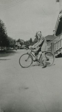
Teacher on a bicycle
https://search.heritageburnaby.ca/link/archivedescription35980
- Repository
- City of Burnaby Archives
- Date
- 1940
- Collection/Fonds
- Burnaby Historical Society fonds
- Description Level
- Item
- Physical Description
- 1 photograph : b&w ; 11 x 6 cm print
- Scope and Content
- Photograph of a teacher on bicycle near the back staircase at Edmonds Street School.
- Repository
- City of Burnaby Archives
- Date
- 1940
- Collection/Fonds
- Burnaby Historical Society fonds
- Subseries
- Edmonds School subseries
- Physical Description
- 1 photograph : b&w ; 11 x 6 cm print
- Description Level
- Item
- Record No.
- 207-029
- Access Restriction
- No restrictions
- Reproduction Restriction
- No known restrictions
- Accession Number
- BHS1988-07
- Scope and Content
- Photograph of a teacher on bicycle near the back staircase at Edmonds Street School.
- Subjects
- Occupations - Teachers
- Names
- Edmonds Community School
- Media Type
- Photograph
- Notes
- Title based on contents of photograph
- Geographic Access
- Edmonds Street
- Street Address
- 7641 Edmonds Street
- Historic Neighbourhood
- Edmonds (Historic Neighbourhood)
- Planning Study Area
- Edmonds Area
Images

![Teachers next to a woodpile, [between 1930 and 1949] thumbnail](/media/hpo/_Data/_Archives_Images/_Unrestricted/205/207-017.jpg?width=280)
Teachers next to a woodpile
https://search.heritageburnaby.ca/link/archivedescription35968
- Repository
- City of Burnaby Archives
- Date
- [between 1930 and 1949]
- Collection/Fonds
- Burnaby Historical Society fonds
- Description Level
- Item
- Physical Description
- 1 photograph : b&w ; 5.5 x 8 cm print
- Scope and Content
- Photograph of four teachers in suits, from the Edmonds Street School, next to a woodpile. Three are seated on the ground, while the fourth is standing with his hands in his pockets.
- Repository
- City of Burnaby Archives
- Date
- [between 1930 and 1949]
- Collection/Fonds
- Burnaby Historical Society fonds
- Subseries
- Edmonds School subseries
- Physical Description
- 1 photograph : b&w ; 5.5 x 8 cm print
- Description Level
- Item
- Record No.
- 207-017
- Access Restriction
- No restrictions
- Reproduction Restriction
- Reproduce for fair dealing purposes only
- Accession Number
- BHS1988-07
- Scope and Content
- Photograph of four teachers in suits, from the Edmonds Street School, next to a woodpile. Three are seated on the ground, while the fourth is standing with his hands in his pockets.
- Subjects
- Occupations - Teachers
- Names
- Edmonds Community School
- Media Type
- Photograph
- Notes
- Title based on contents of photograph
- Geographic Access
- 18th Avenue
- Street Address
- 7651 18th Avenue
- Historic Neighbourhood
- Edmonds (Historic Neighbourhood)
- Planning Study Area
- Edmonds Area
Images
![Teachers next to a woodpile, [between 1930 and 1949] thumbnail](/media/hpo/_Data/_Archives_Images/_Unrestricted/205/207-017.jpg)
![Tramline tracks, [1905] thumbnail](/media/hpo/_Data/_BVM_Images/1990/199500100001.jpg?width=280)
Tramline tracks
https://search.heritageburnaby.ca/link/museumdescription3361
- Repository
- Burnaby Village Museum
- Date
- [1905]
- Collection/Fonds
- Burnaby Village Museum Photograph collection
- Description Level
- Item
- Physical Description
- 1 photograph : b&w ; 15 x 25.5 cm print
- Scope and Content
- Photograph of a British Columbia Electric Railway Company tramline track on Sixth Street and Twelfth Avenue. George Leaf's General Store, located at 7745 Sixth Street is visible on the left and Cliff's Car Factory located at 7730 Sixth Street is visible on the right. George Leaf's store burned down…
- Repository
- Burnaby Village Museum
- Collection/Fonds
- Burnaby Village Museum Photograph collection
- Description Level
- Item
- Physical Description
- 1 photograph : b&w ; 15 x 25.5 cm print
- Scope and Content
- Photograph of a British Columbia Electric Railway Company tramline track on Sixth Street and Twelfth Avenue. George Leaf's General Store, located at 7745 Sixth Street is visible on the left and Cliff's Car Factory located at 7730 Sixth Street is visible on the right. George Leaf's store burned down in 1913. The Car factory was established in 1902 and sometime in the 1920s, it became James Brookes Woodworking Plant.
- Subjects
- Transportation - Electric Railroads
- Buildings - Commercial - General Stores
- Buildings - Industrial - Factories
- Geographic Access
- 6th Street
- 12th Avenue
- Street Address
- 7730 6th Street
- 7745 6th Street
- Accession Code
- BV995.10.1
- Access Restriction
- No restrictions
- Date
- [1905]
- Media Type
- Photograph
- Historic Neighbourhood
- East Burnaby (Historic Neighbourhood)
- Planning Study Area
- Edmonds Area
- Notes
- Title based on contents of photograph
Images
![Tramline tracks, [1905] thumbnail](/media/hpo/_Data/_BVM_Images/1990/199500100001.jpg)

Twelfth Avenue Elementary School
https://search.heritageburnaby.ca/link/archivedescription62707
- Repository
- City of Burnaby Archives
- Date
- September 10, 2009
- Collection/Fonds
- Community Heritage Commission Special Projects fonds
- Description Level
- Item
- Physical Description
- 1 photograph (tiff) : col. ; 600 ppi
- Scope and Content
- Photograph of Twelfth Avenue Elementary School.
- Repository
- City of Burnaby Archives
- Date
- September 10, 2009
- Collection/Fonds
- Community Heritage Commission Special Projects fonds
- Physical Description
- 1 photograph (tiff) : col. ; 600 ppi
- Description Level
- Item
- Record No.
- 503-038
- Access Restriction
- No restrictions
- Reproduction Restriction
- No restrictions
- Accession Number
- 2009-10
- Scope and Content
- Photograph of Twelfth Avenue Elementary School.
- Subjects
- Buildings - Schools
- Media Type
- Photograph
- Photographer
- Pasch, Rebecca
- Notes
- Title based on contents of photograph
- Geographic Access
- 12th Avenue
- Street Address
- 7622 12th Avenue
- Historic Neighbourhood
- Edmonds (Historic Neighbourhood)
- Planning Study Area
- Edmonds Area
Images

![Twelfth Avenue Elementary School graffiti clean-up program, [2000] thumbnail](/media/hpo/_Data/_Archives_Images/_Unrestricted/535/535-2101-1.jpg?width=280)
Twelfth Avenue Elementary School graffiti clean-up program
https://search.heritageburnaby.ca/link/archivedescription96440
- Repository
- City of Burnaby Archives
- Date
- [2000]
- Collection/Fonds
- Burnaby NewsLeader photograph collection
- Description Level
- File
- Physical Description
- 2 photographs (tiff) : col.
- Scope and Content
- File contains photographs of students Keyshaa Hunt, Chad Allen, and Derek Sorensen cleaning graffiti from playground equipment and surfaces as part of a graffiti clean-up program with the Burnaby RCMP at Twelfth Avenue Elementary School.
- Repository
- City of Burnaby Archives
- Date
- [2000]
- Collection/Fonds
- Burnaby NewsLeader photograph collection
- Physical Description
- 2 photographs (tiff) : col.
- Description Level
- File
- Record No.
- 535-2101
- Access Restriction
- No restrictions
- Reproduction Restriction
- No restrictions
- Accession Number
- 2018-12
- Scope and Content
- File contains photographs of students Keyshaa Hunt, Chad Allen, and Derek Sorensen cleaning graffiti from playground equipment and surfaces as part of a graffiti clean-up program with the Burnaby RCMP at Twelfth Avenue Elementary School.
- Media Type
- Photograph
- Photographer
- Bartel, Mario
- Notes
- Title based on caption
- Collected by editorial for use in a March 2000 issue of the Burnaby NewsLeader
- Caption from metadata for 535-2101-1: "Keyshaa Hunt, 12, scrubs the grafitti off the playground equipment at 12th Ave. Elementary School. Students at the school are participating in a joint program with the RCMP to clean grafitti from their school."
- Caption from metadata for 535-2101-2: "Chad Allen, 12, and Derek Sorensen, 12, clean the grafitti from playground equipment at 12th Ave. Elementary School, in a joint clean-up program with the Burnaby RCMP."
- Geographic Access
- 12th Avenue
- Street Address
- 7622 12th Avenue
- Historic Neighbourhood
- Edmonds (Historic Neighbourhood)
- Planning Study Area
- Edmonds Area
Images
![Twelfth Avenue Elementary School graffiti clean-up program, [2000] thumbnail](/media/hpo/_Data/_Archives_Images/_Unrestricted/535/535-2101-1.jpg)
![Twelfth Avenue Elementary School playground fire, [2000] thumbnail](/media/hpo/_Data/_Archives_Images/_Unrestricted/535/535-2534.jpg?width=280)
Twelfth Avenue Elementary School playground fire
https://search.heritageburnaby.ca/link/archivedescription96980
- Repository
- City of Burnaby Archives
- Date
- [2000]
- Collection/Fonds
- Burnaby NewsLeader photograph collection
- Description Level
- Item
- Physical Description
- 1 photograph (tiff) : col.
- Scope and Content
- Photograph of two firefighters hosing down burned-up playground equipment at Twelfth Avenue Elementary School after a fire.
- Repository
- City of Burnaby Archives
- Date
- [2000]
- Collection/Fonds
- Burnaby NewsLeader photograph collection
- Physical Description
- 1 photograph (tiff) : col.
- Description Level
- Item
- Record No.
- 535-2534
- Access Restriction
- No restrictions
- Reproduction Restriction
- No restrictions
- Accession Number
- 2018-12
- Scope and Content
- Photograph of two firefighters hosing down burned-up playground equipment at Twelfth Avenue Elementary School after a fire.
- Media Type
- Photograph
- Photographer
- Bartel, Mario
- Notes
- Title based on caption
- Collected by editorial for use in a July 2000 issue of the Burnaby NewsLeader
- Caption from metadata: "Burnaby firefighters hose down the charred remains of the playground equipment behind Twelfth Avenue School, near a large propane storage tank."
- Geographic Access
- 12th Avenue
- Street Address
- 7622 12th Avenue
- Historic Neighbourhood
- Edmonds (Historic Neighbourhood)
- Planning Study Area
- Edmonds Area
Images
![Twelfth Avenue Elementary School playground fire, [2000] thumbnail](/media/hpo/_Data/_Archives_Images/_Unrestricted/535/535-2534.jpg)
![Twelfth Avenue Elementary Terry Fox Run, [2001] thumbnail](/media/hpo/_Data/_Archives_Images/_Unrestricted/535/535-2745-2.jpg?width=280)
Twelfth Avenue Elementary Terry Fox Run
https://search.heritageburnaby.ca/link/archivedescription97369
- Repository
- City of Burnaby Archives
- Date
- [2001]
- Collection/Fonds
- Burnaby NewsLeader photograph collection
- Description Level
- File
- Physical Description
- 3 photographs (tiff) : col.
- Scope and Content
- File contains photographs of unidentified Twelfth Avenue Elementary students participating in the school's Terry Fox Run event. Photographs depict students walking and running the school's 400m outdoor track and taking refreshment breaks during the event.
- Repository
- City of Burnaby Archives
- Date
- [2001]
- Collection/Fonds
- Burnaby NewsLeader photograph collection
- Physical Description
- 3 photographs (tiff) : col.
- Description Level
- File
- Record No.
- 535-2745
- Access Restriction
- No restrictions
- Reproduction Restriction
- No restrictions
- Accession Number
- 2018-12
- Scope and Content
- File contains photographs of unidentified Twelfth Avenue Elementary students participating in the school's Terry Fox Run event. Photographs depict students walking and running the school's 400m outdoor track and taking refreshment breaks during the event.
- Media Type
- Photograph
- Photographer
- Bartel, Mario
- Notes
- Title based on caption
- Collected by editorial for use in a September 2001 issue of the Burnaby NewsLeader
- Caption from metadata for 535-2745-1: "Students participating in Twelfth Avenue Elementary School's Terry Fox Run line up to get a refreshment break during their first lunch hour running session. The students are running around a 400 meter track before and after school, and during their lunch hour, with the goal for the whole school to accumulate the same mileage as Terry Fox completed on his run."
- Caption from metadata for 535-2745-2: "Kurt Gurney, a Grade 5/6 teacher at Burnaby's Twelfth Avenue Elementary School, hands out tickets to students participating in the school's Terry Fox Run. The students get a ticket for every lap they run around a 400 meter circuit, with the goal to accumulate, by the end of the week, the same mileage that Terry Fox was able to achieve on his cross-country trek."
- Caption from metadata for 535-2745-3: "Students at Burnaby's Twelfth Avenue Elementary School participate in the school's week-long Terry Fox event. Students are given tickets for every lap of a 400 meter track they are able to complete before and after school, and during lunch hours and recess, to compare the school's total accumulated mileage to Fox's actual run."
- Geographic Access
- 12th Avenue
- Street Address
- 7622 12th Avenue
- Historic Neighbourhood
- Edmonds (Historic Neighbourhood)
- Planning Study Area
- Edmonds Area
Images
![Twelfth Avenue Elementary Terry Fox Run, [2001] thumbnail](/media/hpo/_Data/_Archives_Images/_Unrestricted/535/535-2745-2.jpg)
![Vacant house after an explosion, [2000] thumbnail](/media/hpo/_Data/_Archives_Images/_Unrestricted/535/535-2430.jpg?width=280)
Vacant house after an explosion
https://search.heritageburnaby.ca/link/archivedescription96872
- Repository
- City of Burnaby Archives
- Date
- [2000]
- Collection/Fonds
- Burnaby NewsLeader photograph collection
- Description Level
- Item
- Physical Description
- 1 photograph (tiff) : col.
- Scope and Content
- Photograph of a Burnaby Fire Department investigator inspecting a vacant house that exploded and caught fire in the 7800 block of Canada Way.
- Repository
- City of Burnaby Archives
- Date
- [2000]
- Collection/Fonds
- Burnaby NewsLeader photograph collection
- Physical Description
- 1 photograph (tiff) : col.
- Description Level
- Item
- Record No.
- 535-2430
- Access Restriction
- No restrictions
- Reproduction Restriction
- No restrictions
- Accession Number
- 2018-12
- Scope and Content
- Photograph of a Burnaby Fire Department investigator inspecting a vacant house that exploded and caught fire in the 7800 block of Canada Way.
- Subjects
- Occupations - Fire Fighters
- Accidents
- Names
- Burnaby Fire Department
- Media Type
- Photograph
- Photographer
- Bartel, Mario
- Notes
- Title based on caption
- Collected by editorial for use in a June 2000 issue of the Burnaby NewsLeader
- Caption from metadata: "Burnaby fire investigator sifts through the wreckage of a vacant house in the 7800 block of Canada Way which exploded and caught fire early Thursday morning."
- Geographic Access
- Canada Way
- Historic Neighbourhood
- Edmonds (Historic Neighbourhood)
- Planning Study Area
- Edmonds Area
Images
![Vacant house after an explosion, [2000] thumbnail](/media/hpo/_Data/_Archives_Images/_Unrestricted/535/535-2430.jpg)
![Vancouver Opera at Twelfth Avenue Elementary School, [2000] thumbnail](/media/hpo/_Data/_Archives_Images/_Unrestricted/535/535-2112-1.jpg?width=280)
Vancouver Opera at Twelfth Avenue Elementary School
https://search.heritageburnaby.ca/link/archivedescription96488
- Repository
- City of Burnaby Archives
- Date
- [2000]
- Collection/Fonds
- Burnaby NewsLeader photograph collection
- Description Level
- File
- Physical Description
- 2 photographs (tiff) : b&w and col.
- Scope and Content
- File contains photographs of the Vancouver Opera performing "The Magic Potion" as part of a touring presentation at Twelfth Avenue Elementary School. Photographs depict Sung Chung, Julia Bonnett, James McLennan, and Gaetan Labbe posing in costume and Sung Chung performing.
- Repository
- City of Burnaby Archives
- Date
- [2000]
- Collection/Fonds
- Burnaby NewsLeader photograph collection
- Physical Description
- 2 photographs (tiff) : b&w and col.
- Description Level
- File
- Record No.
- 535-2112
- Access Restriction
- No restrictions
- Reproduction Restriction
- No restrictions
- Accession Number
- 2018-12
- Scope and Content
- File contains photographs of the Vancouver Opera performing "The Magic Potion" as part of a touring presentation at Twelfth Avenue Elementary School. Photographs depict Sung Chung, Julia Bonnett, James McLennan, and Gaetan Labbe posing in costume and Sung Chung performing.
- Media Type
- Photograph
- Photographer
- Bartel, Mario
- Notes
- Title based on caption
- Collected by editorial for use in a March 2000 issue of the Burnaby NewsLeader
- Caption from metadata for 535-2112-1: "Sung Chung, Julia Bonnett, James McLennan and Gaetan Labbe, of Vancouver Opera, perform for students at 12th Ave. Elementary."
- Caption from metadata for 535-2112-2: "Sung Chung, the strongman, performs a number from "The Magic Potion," a touring presentation Vancouver Opera brought to 12th Ave. Elementary School."
- Geographic Access
- 12th Avenue
- Street Address
- 7622 12th Avenue
- Historic Neighbourhood
- Edmonds (Historic Neighbourhood)
- Planning Study Area
- Edmonds Area
Images
![Vancouver Opera at Twelfth Avenue Elementary School, [2000] thumbnail](/media/hpo/_Data/_Archives_Images/_Unrestricted/535/535-2112-1.jpg)
![Walker family home, [195-] (date of original); 2013 (date of duplication) thumbnail](/media/hpo/_Data/_Archives_Images/_Unrestricted/550/557-006.jpg?width=280)
Walker family home
https://search.heritageburnaby.ca/link/archivedescription78740
- Repository
- City of Burnaby Archives
- Date
- [195-] (date of original); 2013 (date of duplication)
- Collection/Fonds
- Walker family fonds
- Description Level
- Item
- Physical Description
- 1 photograph (jpeg) : b&w ; 200 dpi
- Scope and Content
- Photograph of the Scotty and Elizabeth Walker family home on Twelfth Avenue in Burnaby.
- Repository
- City of Burnaby Archives
- Date
- [195-] (date of original); 2013 (date of duplication)
- Collection/Fonds
- Walker family fonds
- Physical Description
- 1 photograph (jpeg) : b&w ; 200 dpi
- Description Level
- Item
- Record No.
- 557-006
- Access Restriction
- No restrictions
- Reproduction Restriction
- No restrictions
- Accession Number
- 2013-15
- Scope and Content
- Photograph of the Scotty and Elizabeth Walker family home on Twelfth Avenue in Burnaby.
- Subjects
- Buildings - Residential - Houses
- Media Type
- Photograph
- Notes
- Title based on contents of photograph
- Geographic Access
- 12th Avenue
- Historic Neighbourhood
- Edmonds (Historic Neighbourhood)
- Planning Study Area
- Edmonds Area
Images
![Walker family home, [195-] (date of original); 2013 (date of duplication) thumbnail](/media/hpo/_Data/_Archives_Images/_Unrestricted/550/557-006.jpg)
![Walker family property, [1948] (date of original); 2013 (date of duplication) thumbnail](/media/hpo/_Data/_Archives_Images/_Unrestricted/550/557-008.jpg?width=280)
Walker family property
https://search.heritageburnaby.ca/link/archivedescription78744
- Repository
- City of Burnaby Archives
- Date
- [1948] (date of original); 2013 (date of duplication)
- Collection/Fonds
- Walker family fonds
- Description Level
- Item
- Physical Description
- 1 photograph (jpeg) : b&w ; 300 dpi
- Scope and Content
- Photograph of the Scotty and Elizabeth Walker family property at Twelfth Avenue in Burnaby. This photograph was taken looking towards the Lady of Mercy Church.
- Repository
- City of Burnaby Archives
- Date
- [1948] (date of original); 2013 (date of duplication)
- Collection/Fonds
- Walker family fonds
- Physical Description
- 1 photograph (jpeg) : b&w ; 300 dpi
- Description Level
- Item
- Record No.
- 557-008
- Access Restriction
- No restrictions
- Reproduction Restriction
- No known restrictions
- Accession Number
- 2013-15
- Scope and Content
- Photograph of the Scotty and Elizabeth Walker family property at Twelfth Avenue in Burnaby. This photograph was taken looking towards the Lady of Mercy Church.
- Subjects
- Land Clearing
- Media Type
- Photograph
- Notes
- Title based on contents of photograph
- Geographic Access
- 12th Avenue
- Historic Neighbourhood
- Edmonds (Historic Neighbourhood)
- Planning Study Area
- Edmonds Area
Images
![Walker family property, [1948] (date of original); 2013 (date of duplication) thumbnail](/media/hpo/_Data/_Archives_Images/_Unrestricted/550/557-008.jpg)
![Walker family property, [1948] (date of original); 2013 (date of duplication) thumbnail](/media/hpo/_Data/_Archives_Images/_Unrestricted/550/557-009.jpg?width=280)
Walker family property
https://search.heritageburnaby.ca/link/archivedescription78746
- Repository
- City of Burnaby Archives
- Date
- [1948] (date of original); 2013 (date of duplication)
- Collection/Fonds
- Walker family fonds
- Description Level
- Item
- Physical Description
- 1 photograph (jpeg) : b&w ; 300 dpi
- Scope and Content
- Photograph of the Scotty and Elizabeth Walker family property at Twelfth Avenue in Burnaby. This photograph was taken looking towards the Lady of Mercy Church.
- Repository
- City of Burnaby Archives
- Date
- [1948] (date of original); 2013 (date of duplication)
- Collection/Fonds
- Walker family fonds
- Physical Description
- 1 photograph (jpeg) : b&w ; 300 dpi
- Description Level
- Item
- Record No.
- 557-009
- Access Restriction
- No restrictions
- Reproduction Restriction
- No known restrictions
- Accession Number
- 2013-15
- Scope and Content
- Photograph of the Scotty and Elizabeth Walker family property at Twelfth Avenue in Burnaby. This photograph was taken looking towards the Lady of Mercy Church.
- Subjects
- Land Clearing
- Media Type
- Photograph
- Notes
- Title based on contents of photograph
- Geographic Access
- 12th Avenue
- Historic Neighbourhood
- Edmonds (Historic Neighbourhood)
- Planning Study Area
- Edmonds Area
Images
![Walker family property, [1948] (date of original); 2013 (date of duplication) thumbnail](/media/hpo/_Data/_Archives_Images/_Unrestricted/550/557-009.jpg)
![Walker family property, [1948] (date of original); 2013 (date of duplication) thumbnail](/media/hpo/_Data/_Archives_Images/_Unrestricted/550/557-010.jpg?width=280)
Walker family property
https://search.heritageburnaby.ca/link/archivedescription78747
- Repository
- City of Burnaby Archives
- Date
- [1948] (date of original); 2013 (date of duplication)
- Collection/Fonds
- Walker family fonds
- Description Level
- Item
- Physical Description
- 1 photograph (jpeg) : b&w ; 300 dpi
- Scope and Content
- Photograph of the Scotty and Elizabeth Walker family property at 12th Avenue in Burnaby. This photograph was taken looking towards billboards and a gas station on 12th Street.
- Repository
- City of Burnaby Archives
- Date
- [1948] (date of original); 2013 (date of duplication)
- Collection/Fonds
- Walker family fonds
- Physical Description
- 1 photograph (jpeg) : b&w ; 300 dpi
- Description Level
- Item
- Record No.
- 557-010
- Access Restriction
- No restrictions
- Reproduction Restriction
- No known restrictions
- Accession Number
- 2013-15
- Scope and Content
- Photograph of the Scotty and Elizabeth Walker family property at 12th Avenue in Burnaby. This photograph was taken looking towards billboards and a gas station on 12th Street.
- Subjects
- Land Clearing
- Media Type
- Photograph
- Notes
- Title based on contents of photograph
- Geographic Access
- 12th Avenue
- Historic Neighbourhood
- Edmonds (Historic Neighbourhood)
- Planning Study Area
- Edmonds Area
Images
![Walker family property, [1948] (date of original); 2013 (date of duplication) thumbnail](/media/hpo/_Data/_Archives_Images/_Unrestricted/550/557-010.jpg)
![Walker family property, [1948] (date of original); 2013 (date of duplication) thumbnail](/media/hpo/_Data/_Archives_Images/_Unrestricted/550/557-011.jpg?width=280)
Walker family property
https://search.heritageburnaby.ca/link/archivedescription78749
- Repository
- City of Burnaby Archives
- Date
- [1948] (date of original); 2013 (date of duplication)
- Collection/Fonds
- Walker family fonds
- Description Level
- Item
- Physical Description
- 1 photograph (jpeg) : b&w ; 200 dpi
- Scope and Content
- Photograph of Scotty Walker and working with one of his sons to clear their property at Twelfth Avenue in Burnaby.
- Repository
- City of Burnaby Archives
- Date
- [1948] (date of original); 2013 (date of duplication)
- Collection/Fonds
- Walker family fonds
- Physical Description
- 1 photograph (jpeg) : b&w ; 200 dpi
- Description Level
- Item
- Record No.
- 557-011
- Access Restriction
- No restrictions
- Reproduction Restriction
- No known restrictions
- Accession Number
- 2013-15
- Scope and Content
- Photograph of Scotty Walker and working with one of his sons to clear their property at Twelfth Avenue in Burnaby.
- Subjects
- Land Clearing
- Names
- Walker, Scotty
- Media Type
- Photograph
- Notes
- Title based on contents of photograph
- Geographic Access
- 12th Avenue
- Historic Neighbourhood
- Edmonds (Historic Neighbourhood)
- Planning Study Area
- Edmonds Area
Images
![Walker family property, [1948] (date of original); 2013 (date of duplication) thumbnail](/media/hpo/_Data/_Archives_Images/_Unrestricted/550/557-011.jpg)
![Walker family property, [1948] (date of original); 2013 (date of duplication) thumbnail](/media/hpo/_Data/_Archives_Images/_Unrestricted/550/557-012.jpg?width=280)
Walker family property
https://search.heritageburnaby.ca/link/archivedescription78751
- Repository
- City of Burnaby Archives
- Date
- [1948] (date of original); 2013 (date of duplication)
- Collection/Fonds
- Walker family fonds
- Description Level
- Item
- Physical Description
- 1 photograph (jpeg) : b&w ; 96 dpi
- Scope and Content
- Photograph of the Scotty and Elizabeth Walker family property at Twelfth Avenue in Burnaby flooded with rain that froze over. This photograph was taken looking towards Henley Street.
- Repository
- City of Burnaby Archives
- Date
- [1948] (date of original); 2013 (date of duplication)
- Collection/Fonds
- Walker family fonds
- Physical Description
- 1 photograph (jpeg) : b&w ; 96 dpi
- Description Level
- Item
- Record No.
- 557-012
- Access Restriction
- No restrictions
- Reproduction Restriction
- No known restrictions
- Accession Number
- 2013-15
- Scope and Content
- Photograph of the Scotty and Elizabeth Walker family property at Twelfth Avenue in Burnaby flooded with rain that froze over. This photograph was taken looking towards Henley Street.
- Subjects
- Natural Phenomena - Floods
- Media Type
- Photograph
- Notes
- Title based on contents of photograph
- Geographic Access
- 12th Avenue
- Historic Neighbourhood
- Edmonds (Historic Neighbourhood)
- Planning Study Area
- Edmonds Area
Images
![Walker family property, [1948] (date of original); 2013 (date of duplication) thumbnail](/media/hpo/_Data/_Archives_Images/_Unrestricted/550/557-012.jpg)