Narrow Results By
Subject
- Accidents 1
- Advertising Medium 3
- Advertising Medium - Signs and Signboards 19
- Agriculture - Crops 2
- Agriculture - Fruit and Berries 1
- Animals - Cats 4
- Animals - Dogs 6
- Animals - Poultry 1
- Building Components 1
- Buildings - Civic - Community Centres 1
- Buildings - Civic - Fire Halls 1
- Buildings - Commercial 2
Creator
- Barrowclough, George Alfred 4
- Bridgman's Studio Limited 2
- British Columbia Underwriters' Association 7
- Brown, William Thomas 4
- Bryce, Henry G. 1
- Burnaby Village Museum 2
- Burnett and McGugan B.C. Land Surveyors, New Westminster 1
- Burnett & McGugan, Engineers and Surveyors 2
- Cantlon, Harry 8
- City of Burnaby 1
- Debbie Liang 1
- Diack, George 5

Mr. and Mrs. C.W. Jaggs at opening of Simpsons-Sears
https://search.heritageburnaby.ca/link/museumdescription17334
- Repository
- Burnaby Village Museum
- Date
- 5 May 1954
- Collection/Fonds
- Simpsons-Sears Limited Burnaby fonds
- Description Level
- Item
- Physical Description
- 1 photograph : b&w ; 20.5 x 25.5 cm
- Scope and Content
- Photograph of (left to right) Mrs. C.W. Jaggs, Mr. C.W. Jaggs, Mail Order Manager, Burnaby and an unidentified member of Simpsons-Sears staff or executive inside the Simpsons-Sears store in Burnaby during the opening on May 5, 1954.
- Repository
- Burnaby Village Museum
- Collection/Fonds
- Simpsons-Sears Limited Burnaby fonds
- Description Level
- Item
- Physical Description
- 1 photograph : b&w ; 20.5 x 25.5 cm
- Scope and Content
- Photograph of (left to right) Mrs. C.W. Jaggs, Mr. C.W. Jaggs, Mail Order Manager, Burnaby and an unidentified member of Simpsons-Sears staff or executive inside the Simpsons-Sears store in Burnaby during the opening on May 5, 1954.
- Geographic Access
- Kingsway
- Street Address
- 4750 Kingsway
- Accession Code
- BV021.26.84
- Access Restriction
- No restrictions
- Reproduction Restriction
- May be restricted by third party rights
- Date
- 5 May 1954
- Media Type
- Photograph
- Historic Neighbourhood
- Central Park (Historic Neighbourhood)
- Planning Study Area
- Maywood Area
- Photographer
- On-The-Spot Photographers
- Notes
- Title based on contents of photograph
- Photograph was removed from original scrapbook with newspaper clippings, photographs and ephemera
- Stamp on verso of photograph reads: "ON-THE-SPOT PHOTOGRAPHERS / NEW WESTMINSTER B.C."
Images


Municipality of Burnaby - Volume XV and Volume XVIII
https://search.heritageburnaby.ca/link/museumdescription8680
- Repository
- Burnaby Village Museum
- Date
- May 1927
- Collection/Fonds
- Burnaby Village Museum Map collection
- Description Level
- File
- Physical Description
- 4 plans on 4 sheets : col. lithographic prints ; 63.5 x 53.5 cm folded to 53 x 31.5 cm
- Scope and Content
- File consists of four pages of plans removed from a bound book containing a series of fire insurance plans of the Municipality of Burnaby. The first two pages are numbered "A" and "B" and are key plans from "GREATER VANCOUVER B.C. / VOLUME XV / Surveyed _ May 1927 / MUNICIPALITY OF / BURNABY", "PLA…
- Repository
- Burnaby Village Museum
- Collection/Fonds
- Burnaby Village Museum Map collection
- Description Level
- File
- Physical Description
- 4 plans on 4 sheets : col. lithographic prints ; 63.5 x 53.5 cm folded to 53 x 31.5 cm
- Material Details
- Scales [1:1200] and [1:6000]
- Scope and Content
- File consists of four pages of plans removed from a bound book containing a series of fire insurance plans of the Municipality of Burnaby. The first two pages are numbered "A" and "B" and are key plans from "GREATER VANCOUVER B.C. / VOLUME XV / Surveyed _ May 1927 / MUNICIPALITY OF / BURNABY", "PLAN DEPT. FIRE BRANCH _ B.C. INSURANCE UNDERWRITERS ASSN.". Key Plan "B" covers plans: 1505; 1506; 1512 to 1516; 1540 to 1544; 1550 to 1557 and District Lots: 129 to 132; 135 to 138; 205 to 208 and 215 to 218. Key Plan "A" covers plans: 1501 to 1504; 1507 to 1511; 1517 to 1525; 1531 to 1539; 1545 to 1550 and District Lots: 116 to 127 and 186 to 189. Plan "1806" is part of "GREATER VANCOUVER B.C. / VOLUME XVIII / Municipality of Burnaby / May, 1927" and covers District Lot 153. Plan "1807" is from "GREATER VANCOUVER B.C. / VOLUME XVIII / Municipality of Burnaby / May, 1927" and covers District Lots: 99,149 and 152.
- Responsibility
- British Columbia Underwriters' Association
- Accession Code
- HV972.111.2
- Access Restriction
- No restrictions
- Reproduction Restriction
- May be restricted by third party rights
- Date
- May 1927
- Media Type
- Cartographic Material
- Historic Neighbourhood
- Vancouver Heights (Historic Neighbourhood)
- Lochdale (Historic Neighbourhood)
- Capitol Hill (Historic Neighbourhood)
- Central Park (Historic Neighbourhood)
- Alta Vista (Historic Neighbourhood)
- Planning Study Area
- Burnaby Heights Area
- Sperling-Broadway Area
- Lochdale Area
- Parkcrest-Aubrey Area
- Westridge Area
- Willingdon Heights Area
- Capitol Hill Area
- Maywood Area
- Marlborough Area
- Scan Resolution
- 400
- Scan Date
- 2021-11-18
- Notes
- Title based on content of plans
- Scales are measured 1 inch = 100 feet and 1 inch = 500 feet
- See also BV987.1.70d for revised versions of plans
Zoomable Images


Municipality of Burnaby - Volume XV and Volume XVIII
https://search.heritageburnaby.ca/link/museumdescription8681
- Repository
- Burnaby Village Museum
- Date
- May 1927
- Collection/Fonds
- Burnaby Village Museum Map collection
- Description Level
- File
- Physical Description
- 4 plans on 4 sheets : col. lithographic prints, ms. annotations in blue ink ; 63.5 x 53.5 cm folded to 53 x 31.5 cm
- Scope and Content
- File consists of four pages of plans removed from a bound book containing a series of fire insurance plans of the Municipality of Burnaby. Plan "1507" and plan "1517" are from "GREATER VANCOUVER B.C. / VOLUME XV / Municipality of Burnaby / May, 1927". Plan "1507" covers District Lot 186 and plan "1…
- Repository
- Burnaby Village Museum
- Collection/Fonds
- Burnaby Village Museum Map collection
- Description Level
- File
- Physical Description
- 4 plans on 4 sheets : col. lithographic prints, ms. annotations in blue ink ; 63.5 x 53.5 cm folded to 53 x 31.5 cm
- Material Details
- Scale [1:600] and [1:1200]
- Scope and Content
- File consists of four pages of plans removed from a bound book containing a series of fire insurance plans of the Municipality of Burnaby. Plan "1507" and plan "1517" are from "GREATER VANCOUVER B.C. / VOLUME XV / Municipality of Burnaby / May, 1927". Plan "1507" covers District Lot 186 and plan "1517" covers District Lot 116. Plan "1804" and plan "1805" are from "GREATER VANCOUVER B.C. / VOLUME XVIII / Municipality of Burnaby / May, 1927". Plans "1804" and "1805" cover District Lot 153.
- Responsibility
- British Columbia Underwriters' Association
- Accession Code
- HV972.111.3
- Access Restriction
- No restrictions
- Reproduction Restriction
- May be restricted by third party rights
- Date
- May 1927
- Media Type
- Cartographic Material
- Historic Neighbourhood
- Central Park (Historic Neighbourhood)
- Vancouver Heights (Historic Neighbourhood)
- Planning Study Area
- Maywood Area
- Willingdon Heights Area
- Scan Resolution
- 400
- Scan Date
- 2021-11-18
- Notes
- Title based on content of plans
- See also BV987.1.70d for revised versions of plans
- Scale is measured 1 inch = 100 feet
Images


![Municipality of Burnaby - Volume XV and Volume XVIII, 1927-[1940] thumbnail](/media/hpo/_Data/_BVM_Artifacts/1972/1972_0111_0004_003.jpg?width=280)
Municipality of Burnaby - Volume XV and Volume XVIII
https://search.heritageburnaby.ca/link/museumdescription8682
- Repository
- Burnaby Village Museum
- Date
- 1927-[1940]
- Collection/Fonds
- Burnaby Village Museum Map collection
- Description Level
- File
- Physical Description
- 4 plans on 4 sheets: col. lithographic prints ; 63.5 x 53.5 cm folded to 53 x 31.5 cm
- Scope and Content
- File consists of four pages of plans removed from a bound book containing a series of fire insurance plans of the Municipality of Burnaby. Plan "1518" and "1519" are from "GREATER VANCOUVER B.C. / VOLUME XV / Municipality of Burnaby / May, 1927". Plan "1518" covers District Lot 116 and Plan "1519"…
- Repository
- Burnaby Village Museum
- Collection/Fonds
- Burnaby Village Museum Map collection
- Description Level
- File
- Physical Description
- 4 plans on 4 sheets: col. lithographic prints ; 63.5 x 53.5 cm folded to 53 x 31.5 cm
- Material Details
- Scale [1:600]
- Scope and Content
- File consists of four pages of plans removed from a bound book containing a series of fire insurance plans of the Municipality of Burnaby. Plan "1518" and "1519" are from "GREATER VANCOUVER B.C. / VOLUME XV / Municipality of Burnaby / May, 1927". Plan "1518" covers District Lot 116 and Plan "1519" covers District Lot 121. Plan "1802" and plan "1803" are from "GREATER VANCOUVER B.C. / VOLUME XVIII / Municipality of Burnaby / May, 1927". Both plans "1802" and "1803" cover District Lot 153.
- Responsibility
- British Columbia Underwriters' Association
- Accession Code
- HV972.111.4
- Access Restriction
- No restrictions
- Reproduction Restriction
- May be restricted by third party rights
- Date
- 1927-[1940]
- Media Type
- Cartographic Material
- Historic Neighbourhood
- Vancouver Heights (Historic Neighbourhood)
- Central Park (Historic Neighbourhood)
- Planning Study Area
- Willingdon Heights Area
- Marlborough Area
- Scan Resolution
- 400
- Scan Date
- 2021-11-18
- Notes
- Title based on content of plans
- See also BV987.1.70d for revised versions of plans
- Scale is measured 1 inch = 50 feet
- Contact Burnaby Village Museum to access plans 1518 and 1519 (these plans have revisions on top - date of revisions is uncertain)
Images
![Municipality of Burnaby - Volume XV and Volume XVIII, 1927-[1940] thumbnail](/media/hpo/_Data/_BVM_Artifacts/1972/1972_0111_0004_003.jpg)


Municipality of Burnaby - Volume XVI and Volume XVII
https://search.heritageburnaby.ca/link/museumdescription8684
- Repository
- Burnaby Village Museum
- Date
- May 1927
- Collection/Fonds
- Burnaby Village Museum Map collection
- Description Level
- File
- Physical Description
- 4 plans on 4 sheets : col. lithographic prints ; 63.5 x 53.5 cm folded to 53 x 31.5 cm
- Scope and Content
- File consists of four pages of plans removed from a bound book containing a series of fire insurance plans of the Municipality of Burnaby. Page "D" is titled: "GREATER VANCOUVER B.C. / VOLUME XVI / Surveyed _ May 1927 / MUNICIPALITY OF / BURNABY / PLAN DEPT. FIRE BRANCH _ B.C. INSURANCE UNDERWRITE…
- Repository
- Burnaby Village Museum
- Collection/Fonds
- Burnaby Village Museum Map collection
- Description Level
- File
- Physical Description
- 4 plans on 4 sheets : col. lithographic prints ; 63.5 x 53.5 cm folded to 53 x 31.5 cm
- Material Details
- Scale [1:1200] and [1:6000]
- Scope and Content
- File consists of four pages of plans removed from a bound book containing a series of fire insurance plans of the Municipality of Burnaby. Page "D" is titled: "GREATER VANCOUVER B.C. / VOLUME XVI / Surveyed _ May 1927 / MUNICIPALITY OF / BURNABY / PLAN DEPT. FIRE BRANCH _ B.C. INSURANCE UNDERWRITERS ASSN." / KEY PLAN". Plans covered in this "Key Plan" are numbered 1601 to 1626, 1632 and 1651 covering District Lots: 15; 31; 100 to 102; 114; 141 to 144; 147 and 148; 209 to 214. Plan "E" is part of "GREATER VANCOUVER B.C. / VOLUME XVII / Municipality of Burnaby / May 1927" and covers plans: 1701 to 1705; 1711 to 1715; 1723 to 1727; 1729 to 1733; 1737 to 1742 and District Lots: 68 to 74; 80 to 84; 32 to 35 and 38 to 39. Plan marked "F" is a key plan titled: "GREATER VANCOUVER B.C. / VOLUME XVII / Surveyed _ May 1927 / MUNICIPALITY OF / BURNABY and covers plans: 1706 to 1710; 1716 to 1722; 1734 and 1735; 1743 to 1752 and District Lots: 42 to 44; 59; 75 to 80; 83 to 87; 89 to 93 and 130. Plan "1729" is part of "GREATER VANCOUVER B.C. / VOLUME XVII / Municipality of Burnaby / May 1927" and covers District Lots 34 and 35.
- Responsibility
- British Columbia Underwriters' Association
- Accession Code
- HV972.111.6
- Access Restriction
- No restrictions
- Reproduction Restriction
- May be restricted by third party rights
- Date
- May 1927
- Media Type
- Cartographic Material
- Historic Neighbourhood
- Barnet (Historic Neighbourhood)
- Burquitlam (Historic Neighbourhood)
- Central Park (Historic Neighbourhood)
- Burnaby Lake (Historic Neighbourhood)
- Broadview (Historic Neighbourhood)
- Planning Study Area
- Burnaby Mountain Area
- Lyndhurst Area
- Lake City Area
- Cascade-Schou Area
- Garden Village Area
- Douglas-Gilpin Area
- Oakalla Area
- Scan Resolution
- 400
- Scan Date
- 2021-11-18
- Notes
- Title based on content of plans
- See also BV987.1.70d for revised versions of plans
- Scale is measured 1 inch = 500 feet
Zoomable Images


Municipality of Burnaby - Volume XVIII and Volume XIX
https://search.heritageburnaby.ca/link/museumdescription8683
- Repository
- Burnaby Village Museum
- Date
- May 1927
- Collection/Fonds
- Burnaby Village Museum Map collection
- Description Level
- File
- Physical Description
- 2 plans on 2 sheets : col. lithographic prints ; 63.5 x 53.5 cm folded to 53 x 31.5 cm
- Scope and Content
- File consists of two pages of plans removed from a bound book containing a series of fire insurance plans of the Municipality of Burnaby. Plan "1832" is from "GREATER VANCOUVER B.C. / VOLUME XVIII / Municipality of Burnaby / May, 1927" and covers District Lots: 98 and 28. Plan "K" is part of a key …
- Repository
- Burnaby Village Museum
- Collection/Fonds
- Burnaby Village Museum Map collection
- Description Level
- File
- Physical Description
- 2 plans on 2 sheets : col. lithographic prints ; 63.5 x 53.5 cm folded to 53 x 31.5 cm
- Material Details
- Scale [1:1200] to [1:6000]
- Scope and Content
- File consists of two pages of plans removed from a bound book containing a series of fire insurance plans of the Municipality of Burnaby. Plan "1832" is from "GREATER VANCOUVER B.C. / VOLUME XVIII / Municipality of Burnaby / May, 1927" and covers District Lots: 98 and 28. Plan "K" is part of a key plan "GREATER VANCOUVER B.C. / Surveyed VOLUME XIX May 1927 / MUNICIPALITY OF / BURNABY / PLAN DEPT. British Columbia Ins. Underwriters Association / FIRE BRANCH / KEY PLAN", "Scale 500 FT = 1 INCH / FOR REPORT SEE VOL. XV" covering plans: 1901 to 1914 and District Lots: 161; 164 to 167; 155c; 155; 172 and 173.
- Responsibility
- British Columbia Underwriters' Association
- Accession Code
- HV972.111.5
- Access Restriction
- No restrictions
- Reproduction Restriction
- May be restricted by third party rights
- Date
- May 1927
- Media Type
- Cartographic Material
- Historic Neighbourhood
- East Burnaby (Historic Neighbourhood)
- Central Park (Historic Neighbourhood)
- Fraser Arm (Historic Neighbourhood)
- Alta Vista (Historic Neighbourhood)
- Planning Study Area
- Windsor Area
- Marlborough Area
- Second Street Area
- Big Bend Area
- Sussex-Nelson Area
- Scan Resolution
- 400
- Scan Date
- 2021-11-18
- Notes
- Title based on content of plans
- See also BV987.1.70d for revised versions of plans
- Scale is measured 1 inch = 500 feet
Zoomable Images


Municipality of Burnaby - Volume XV, Volume XVI, Volume XVII, Volume XVIII
https://search.heritageburnaby.ca/link/museumdescription8685
- Repository
- Burnaby Village Museum
- Date
- May 1927
- Collection/Fonds
- Burnaby Village Museum Map collection
- Description Level
- File
- Physical Description
- 4 plans on 4 sheets : col. lithographic prints ; 63.5 x 53.5 cm folded to 53 x 31.5 cm
- Scope and Content
- File consists of four pages of plans removed from a bound book containing a series of fire insurance plans of the Municipality of Burnaby. Plan "1531" is part of "GREATER VANCOUVER B.C. / VOLUME XV / Municipality of Burnaby / May 1927" and covers District Lots: 116 and 117. Key Plan "C" is part of …
- Repository
- Burnaby Village Museum
- Collection/Fonds
- Burnaby Village Museum Map collection
- Description Level
- File
- Physical Description
- 4 plans on 4 sheets : col. lithographic prints ; 63.5 x 53.5 cm folded to 53 x 31.5 cm
- Material Details
- Scale [1:600] and [1:1200]
- Scope and Content
- File consists of four pages of plans removed from a bound book containing a series of fire insurance plans of the Municipality of Burnaby. Plan "1531" is part of "GREATER VANCOUVER B.C. / VOLUME XV / Municipality of Burnaby / May 1927" and covers District Lots: 116 and 117. Key Plan "C" is part of "GREATER VANCOUVER B.C. / VOLUME XVI / Municipality of Burnaby / May 1927" and covers plans 1623 to 1651 and District Lots: 1 and 2; 4; 6; 8; 10 to 14; 25; 27; 40; 56 to 58; 88 and 89. Plan "1738" is part of "GREATER VANCOUVER B.C. / VOLUME XVII / Municipality of Burnaby / May 1927" and covers District Lots: 34 and 35. Key plan "G" is part of "GREATER VANCOUVER B.C. / VOLUME XVIII / Municipality of Burnaby / May 1927" and covers plans: 1801 to 1813; 1823; 1824; 1833 to 1838; 1841 to 1853 and District Lots: 32; 93; 94; 97 to 99; 149; 150; 152; 155 to 159; 161 to 164.
- Responsibility
- British Columbia Underwriters' Association
- Accession Code
- HV972.111.7
- Access Restriction
- No restrictions
- Reproduction Restriction
- May be restricted by third party rights
- Date
- May 1927
- Media Type
- Cartographic Material
- Historic Neighbourhood
- Central Park (Historic Neighbourhood)
- Fraser Arm (Historic Neighbourhood)
- Alta Vista (Historic Neighbourhood)
- Broadview (Historic Neighbourhood)
- Vancouver Heights (Historic Neighbourhood)
- Burquitlam (Historic Neighbourhood)
- East Burnaby (Historic Neighbourhood)
- Edmonds (Historic Neighbourhood)
- Lozells (Historic Neighbourhood)
- Planning Study Area
- Clinton-Glenwood Area
- Marlborough Area
- Maywood Area
- Windsor Area
- Big Bend Area
- Garden Village Area
- Willingdon Heights Area
- West Central Valley Area
- Cariboo-Armstrong Area
- Lyndhurst Area
- Cameron Area
- Lake City Area
- Edmonds Area
- Second Street Area
- Sperling-Broadway Area
- Lakeview-Mayfield Area
- Scan Resolution
- 400
- Scan Date
- 2021-11-18
- Notes
- Title based on content of plans
- See also BV987.1.70d for revised versions of plans
- Scale is measured 1 inch = 500 feet
Zoomable Images

Municipality of Burnaby - Volume XV, Volume XVI, Volume XVII, Volume XVIII, May 1927
Zoom into Image
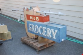
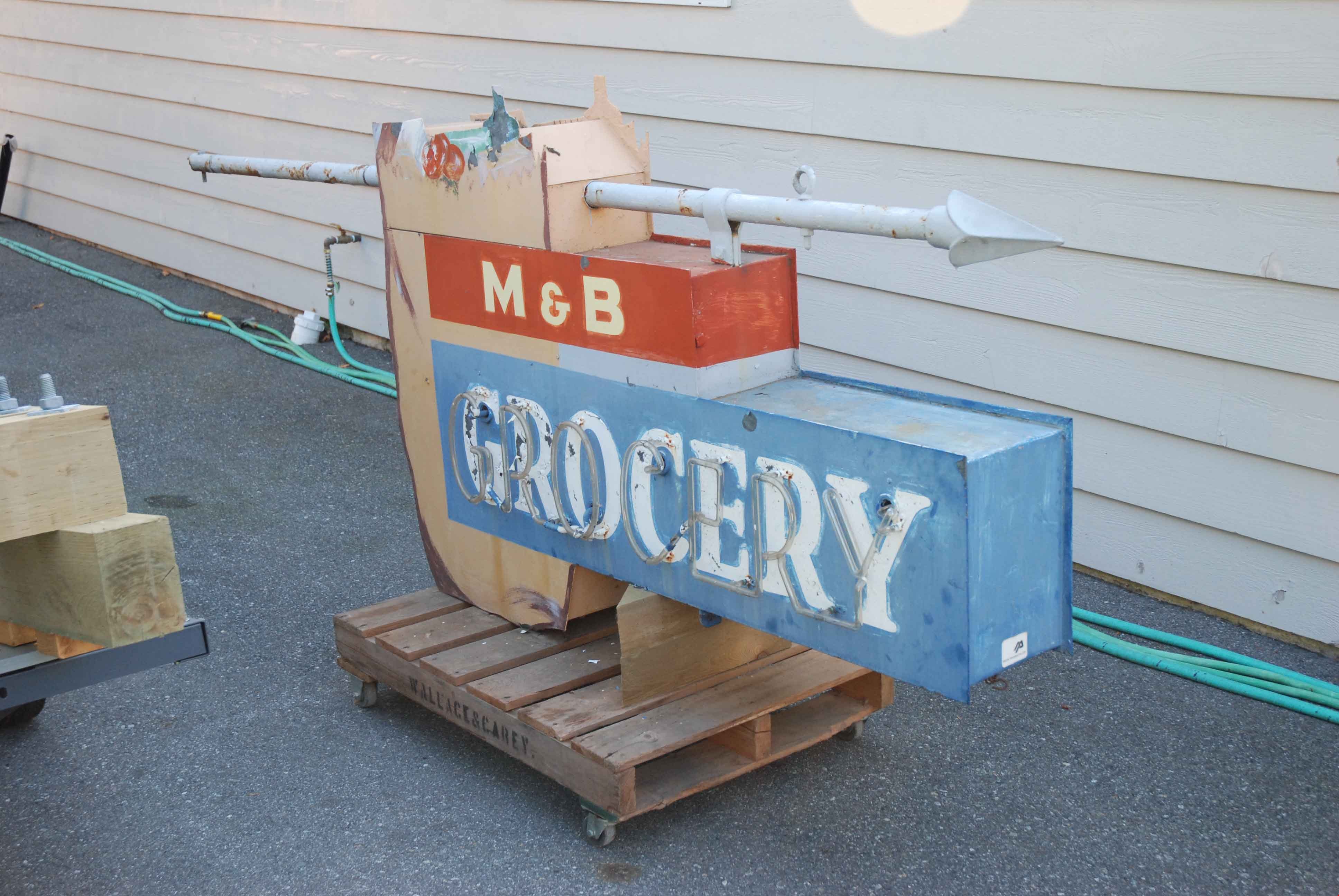
neon sign
https://search.heritageburnaby.ca/link/museumartifact83422
- Repository
- Burnaby Village Museum
- Accession Code
- BV013.15.1
- Description
- Grocery sign The sign is from a neighbourhood grocery on Royal Oak at the Skytrain line: 6949 Royal Oak Avenue. The bulk of the sign is rectangular with a grocery bag and contents extending above the top edge of the sign. The words "M & B / GROCERY" are written in white text, with "GROCERY" highlighted in neon. The sign was suspended from a horizontal pole with a spear like finial that was mounted at the front of the roof or the store.
- Province Made
- British Columbia
- Site/City Made
- Vancouver
- Historic Neighbourhood
- Central Park (Historic Neighbourhood)
- Planning Study Area
- Sussex-Nelson Area
Images
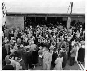
Opening day rush at Simpsons-Sears
https://search.heritageburnaby.ca/link/museumdescription17265
- Repository
- Burnaby Village Museum
- Date
- 5 May 1954
- Collection/Fonds
- Simpsons-Sears Limited Burnaby fonds
- Description Level
- Item
- Physical Description
- 1 photograph : b&w ; 20.5 x 25.5 cm
- Scope and Content
- Photograph of a crowd of shoppers gathered outside of the front doors to the new Simpsons-Sears store on opening day, May 5, 1954.
- Repository
- Burnaby Village Museum
- Collection/Fonds
- Simpsons-Sears Limited Burnaby fonds
- Description Level
- Item
- Physical Description
- 1 photograph : b&w ; 20.5 x 25.5 cm
- Scope and Content
- Photograph of a crowd of shoppers gathered outside of the front doors to the new Simpsons-Sears store on opening day, May 5, 1954.
- Names
- Simpsons-Sears Limited
- Geographic Access
- Kingsway
- Street Address
- 4750 Kingsway
- Accession Code
- BV021.26.13
- Access Restriction
- No restrictions
- Reproduction Restriction
- May be restricted by third party rights
- Date
- 5 May 1954
- Media Type
- Photograph
- Historic Neighbourhood
- Central Park (Historic Neighbourhood)
- Planning Study Area
- Maywood Area
- Notes
- Title based on contents of photograph
- Photograph was removed from original scrapbook with newspaper clippings, photographs and ephemera
Images

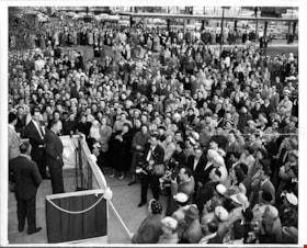
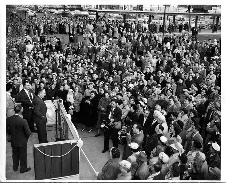
Opening day speeches at Simpsons-Sears
https://search.heritageburnaby.ca/link/museumdescription17266
- Repository
- Burnaby Village Museum
- Date
- 5 May 1954
- Collection/Fonds
- Simpsons-Sears Limited Burnaby fonds
- Description Level
- Item
- Physical Description
- 1 photograph : b&w ; 20.5 x 25.5 cm
- Scope and Content
- Photograph of opening day speeches outside of the Simpsons-Sears store with a crowd gathered. Four dignitaries are standing on a stage before the crowd, including Burnaby Reeve, Charles MacSorley (at the microphone) and Manager of Simpsons-Sears, Burnaby, T. Boyd Haskell, standing to his right.
- Repository
- Burnaby Village Museum
- Collection/Fonds
- Simpsons-Sears Limited Burnaby fonds
- Description Level
- Item
- Physical Description
- 1 photograph : b&w ; 20.5 x 25.5 cm
- Scope and Content
- Photograph of opening day speeches outside of the Simpsons-Sears store with a crowd gathered. Four dignitaries are standing on a stage before the crowd, including Burnaby Reeve, Charles MacSorley (at the microphone) and Manager of Simpsons-Sears, Burnaby, T. Boyd Haskell, standing to his right.
- Subjects
- Officials - Mayors and Reeves
- Officials
- Buildings - Commercial - Department Stores
- Events - Openings
- Persons - Crowds
- Geographic Access
- Kingsway
- Street Address
- 4750 Kingsway
- Accession Code
- BV021.26.14
- Access Restriction
- No restrictions
- Reproduction Restriction
- May be restricted by third party rights
- Date
- 5 May 1954
- Media Type
- Photograph
- Historic Neighbourhood
- Central Park (Historic Neighbourhood)
- Planning Study Area
- Maywood Area
- Notes
- Title based on contents of photograph
- Photograph was removed from original scrapbook with newspaper clippings, photographs and ephemera
Images
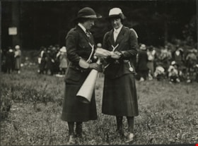
Our Sisters at Girl Guide Rally
https://search.heritageburnaby.ca/link/museumdescription20616
- Repository
- Burnaby Village Museum
- Date
- 6 Jun. 1925
- Collection/Fonds
- David Geoffrey Llewellyn collection
- Description Level
- Item
- Physical Description
- 1 photograph : b&w ; 8 x 10.5 cm
- Scope and Content
- Photograph of unidentified Girl Guide leaders dressed in uniforms at Girl Guide Rally at Central Park. One of the leaders is holding a metal megaphone and the other leader is holding papers.
- Repository
- Burnaby Village Museum
- Collection/Fonds
- David Geoffrey Llewellyn collection
- Description Level
- Item
- Physical Description
- 1 photograph : b&w ; 8 x 10.5 cm
- Scope and Content
- Photograph of unidentified Girl Guide leaders dressed in uniforms at Girl Guide Rally at Central Park. One of the leaders is holding a metal megaphone and the other leader is holding papers.
- Names
- Girl Guides of Canada
- Geographic Access
- Central Park
- Accession Code
- BV995.8.47
- Access Restriction
- No restrictions
- Reproduction Restriction
- No known restrictions
- Date
- 6 Jun. 1925
- Media Type
- Photograph
- Historic Neighbourhood
- Central Park (Historic Neighbourhood)
- Scan Resolution
- 600
- Notes
- Transcribed titled
- Photograph is part of photograph album BV995.8.1, pasted to page 17
- Illustrative designs in white ink around photographs on album page
- Note in white ink on album page reads: "GIRL GUIDE RALLY - CENTRAL PARK / JUNE 6TH 1925 / OUR SISTERS"
Images

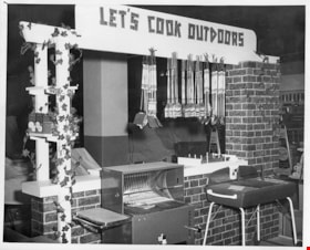
Outdoor BBQ display
https://search.heritageburnaby.ca/link/museumdescription17273
- Repository
- Burnaby Village Museum
- Date
- 5 May 1954
- Collection/Fonds
- Simpsons-Sears Limited Burnaby fonds
- Description Level
- Item
- Physical Description
- 1 photograph : b&w ; 25.5 x 21 cm
- Scope and Content
- Photograph of an outdoor BBQ display with the sign "Let's Cook Outdoors" inside the Simpsons-Sears store on opening day.
- Repository
- Burnaby Village Museum
- Collection/Fonds
- Simpsons-Sears Limited Burnaby fonds
- Description Level
- Item
- Physical Description
- 1 photograph : b&w ; 25.5 x 21 cm
- Scope and Content
- Photograph of an outdoor BBQ display with the sign "Let's Cook Outdoors" inside the Simpsons-Sears store on opening day.
- Names
- Simpsons-Sears Limited
- Geographic Access
- Kingsway
- Street Address
- 4750 Kingsway
- Accession Code
- BV021.26.23
- Access Restriction
- No restrictions
- Reproduction Restriction
- May be restricted by third party rights
- Date
- 5 May 1954
- Media Type
- Photograph
- Historic Neighbourhood
- Central Park (Historic Neighbourhood)
- Planning Study Area
- Maywood Area
- Scan Resolution
- 600
- Scan Date
- 2021-09-21
- Photographer
- Cantlon, Harry
- Notes
- Title based on contents of photograph
- Photograph was removed from original scrapbook with newspaper clippings, photographs and ephemera
- Stamp on verso of photograph reads: "VANCOUVER PROVINCE / Photo by HARR CANTLON"
Images


Painting Centre Line on Kingsway
https://search.heritageburnaby.ca/link/museumdescription65
- Repository
- Burnaby Village Museum
- Date
- 1928 (date of original), copied 1971
- Collection/Fonds
- Burnaby Village Museum Photograph collection
- Description Level
- Item
- Physical Description
- 1 photograph : b&w ; 15.0 x 25.2 cm print
- Scope and Content
- Photograph of Frank Warburton sitting backwards on a plank attached to the front of a car, as it is being driven. The make of the car is unidentified, but has wooden spoked wheels, running boards, and a soft convertible top. Mr. Warburton is painting the centre line on Kingsway. The photograph is…
- Repository
- Burnaby Village Museum
- Collection/Fonds
- Burnaby Village Museum Photograph collection
- Description Level
- Item
- Physical Description
- 1 photograph : b&w ; 15.0 x 25.2 cm print
- Scope and Content
- Photograph of Frank Warburton sitting backwards on a plank attached to the front of a car, as it is being driven. The make of the car is unidentified, but has wooden spoked wheels, running boards, and a soft convertible top. Mr. Warburton is painting the centre line on Kingsway. The photograph is taken 1928 at corner of Grimmer and Kingsway. In the background of the photograph, to the left, there are residential houses with a parked car, and to the right, is a tall gas pump.
- Names
- Warburton, Frank
- Geographic Access
- Kingsway
- Grimmer Street
- Accession Code
- HV971.173.1
- Access Restriction
- No restrictions
- Reproduction Restriction
- No known restrictions
- Date
- 1928 (date of original), copied 1971
- Media Type
- Photograph
- Historic Neighbourhood
- Central Park (Historic Neighbourhood)
- Planning Study Area
- Windsor Area
- Scan Resolution
- 600
- Scan Date
- 2023-03-28
- Notes
- Title based on contents of photograph
- The information in scope and content taken from earlier catalgue record from 1976, and verified by various accession and donation paperworks
Images

![Philips family in dining room at Christmas, [Jan. 1962] thumbnail](/media/hpo/_Data/_BVM_Images/2022/2022_0011_0002_001.jpg?width=280)
Philips family in dining room at Christmas
https://search.heritageburnaby.ca/link/museumdescription19083
- Repository
- Burnaby Village Museum
- Date
- [Jan. 1962]
- Collection/Fonds
- Earl and Adell Philips family fonds
- Description Level
- Item
- Physical Description
- 1 photograph : b&w ; 9 x 9 cm
- Scope and Content
- Photograph of the Philips family seated around a table in their dining room of their house located at 5877 Barker Avenue, Burnaby. People are identified from left to right: Shannon McKeemen and Ann McKeemen, Bob Paterson, Earl Philips, Adell Philips, Lorayne Philips, Cory Philips, Lea Philips, Ju…
- Repository
- Burnaby Village Museum
- Collection/Fonds
- Earl and Adell Philips family fonds
- Description Level
- Item
- Physical Description
- 1 photograph : b&w ; 9 x 9 cm
- Scope and Content
- Photograph of the Philips family seated around a table in their dining room of their house located at 5877 Barker Avenue, Burnaby. People are identified from left to right: Shannon McKeemen and Ann McKeemen, Bob Paterson, Earl Philips, Adell Philips, Lorayne Philips, Cory Philips, Lea Philips, Judith Philips. Photograph was taken during Christmas, everyone is wearing a tissue paper hat and the table cloth has a pointsettia design.
- Names
- Philips, Adell Greenwood
- Philips, Judith
- Philips, Lea
- Philips, Lorayne
- Philips, Earl Gene
- Philips, Cory
- McKeeman, Ann
- McKeeman, Shannon
- Paterson, Bob
- Geographic Access
- Barker Avenue
- Street Address
- 5877 Barker Avenue
- Accession Code
- BV022.11.2
- Access Restriction
- No restrictions
- Reproduction Restriction
- No known restrictions
- Date
- [Jan. 1962]
- Media Type
- Photograph
- Historic Neighbourhood
- Central Park (Historic Neighbourhood)
- Notes
- Title based on contents of photograph
- Stamp along right edge of photo includes print date which reads: "JAN. 62"
- Note in pencil on verso of photograph reads: "Barker Ave. / Christmas 1961"
Images
![Philips family in dining room at Christmas, [Jan. 1962] thumbnail](/media/hpo/_Data/_BVM_Images/2022/2022_0011_0002_001.jpg)
postcard
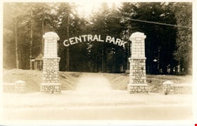
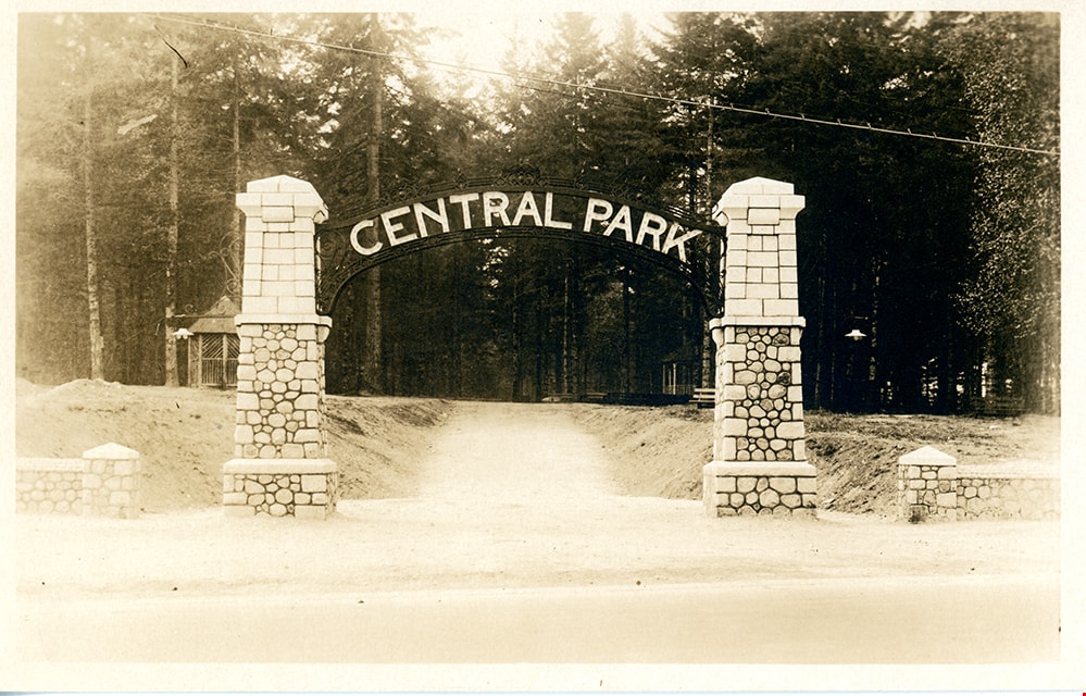
https://search.heritageburnaby.ca/link/museumartifact84668
- Repository
- Burnaby Village Museum
- Accession Code
- BV007.43.1
- Description
- postcard; black and white photograph of entrance arches to Central Park in Burnaby - [192-]. The postcard was published by the Gowen Sutton Company Limited of Vancouver, BC. Stamp in black ink on verso of postcard reads "PUBLISHED BY THE GOWEN SUTTON CO. LTD. VANCOUVER, B.C. / POSTCARD / CORRESPONDENCE_ADDRESS"
- Object History
- Souvenir postcard of Burnaby Central Park entrance arch.
- Classification
- Written Communication T&E - - Writing Media
- Object Term
- Postcard
- Colour
- Brown
- White
- Measurements
- w: 14 cm h: 9 cm
- Country Made
- Canada
- Province Made
- British Columbia
- Site/City Made
- Vancouver
- Subjects
- Structures - Arches
- Documentary Artifacts
- Documentary Artifacts - Postcards
- Geographic Features - Parks
- Geographic Access
- Central Park
- Imperial Street
- Street Address
- 3883 Imperial Street
- Historic Neighbourhood
- Central Park (Historic Neighbourhood)
- Planning Study Area
- Maywood Area
Images

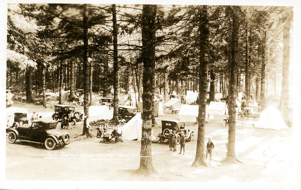
postcard
https://search.heritageburnaby.ca/link/museumartifact84669
- Repository
- Burnaby Village Museum
- Accession Code
- BV007.43.2
- Description
- postcard; Auto Tourist Camp - Postcard -- [1926]. Postcard with a black and white photograph; inscription in white at bottom reads: "Auto Tourist Camp, Central Park B.C." The postcard was published by the Gowen Sutton Company Limited of Vancouver, BC. Verso of postcard includes a postage stamp with King George in the upper right corner and is post marked Sept. 6 and includes a handwritten letter by "Violet" and is addressed to "Roseline Rondeau.../ Oregon".
- Classification
- Written Communication T&E - - Writing Media
- Object Term
- Postcard
- Colour
- Brown
- Black
- White
- Measurements
- w: 14 cm h: 9 cm
- Country Made
- Canada
- Province Made
- British Columbia
- Site/City Made
- Vancouver
- Subjects
- Documentary Artifacts
- Documentary Artifacts - Postcards
- Geographic Features
- Geographic Features - Parks
- Recreational Activities
- Recreational Activities - Camping
- Names
- Central Park Auto Camp
- Historic Neighbourhood
- Central Park (Historic Neighbourhood)
Images
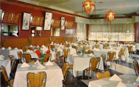
postcard
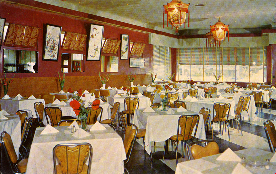
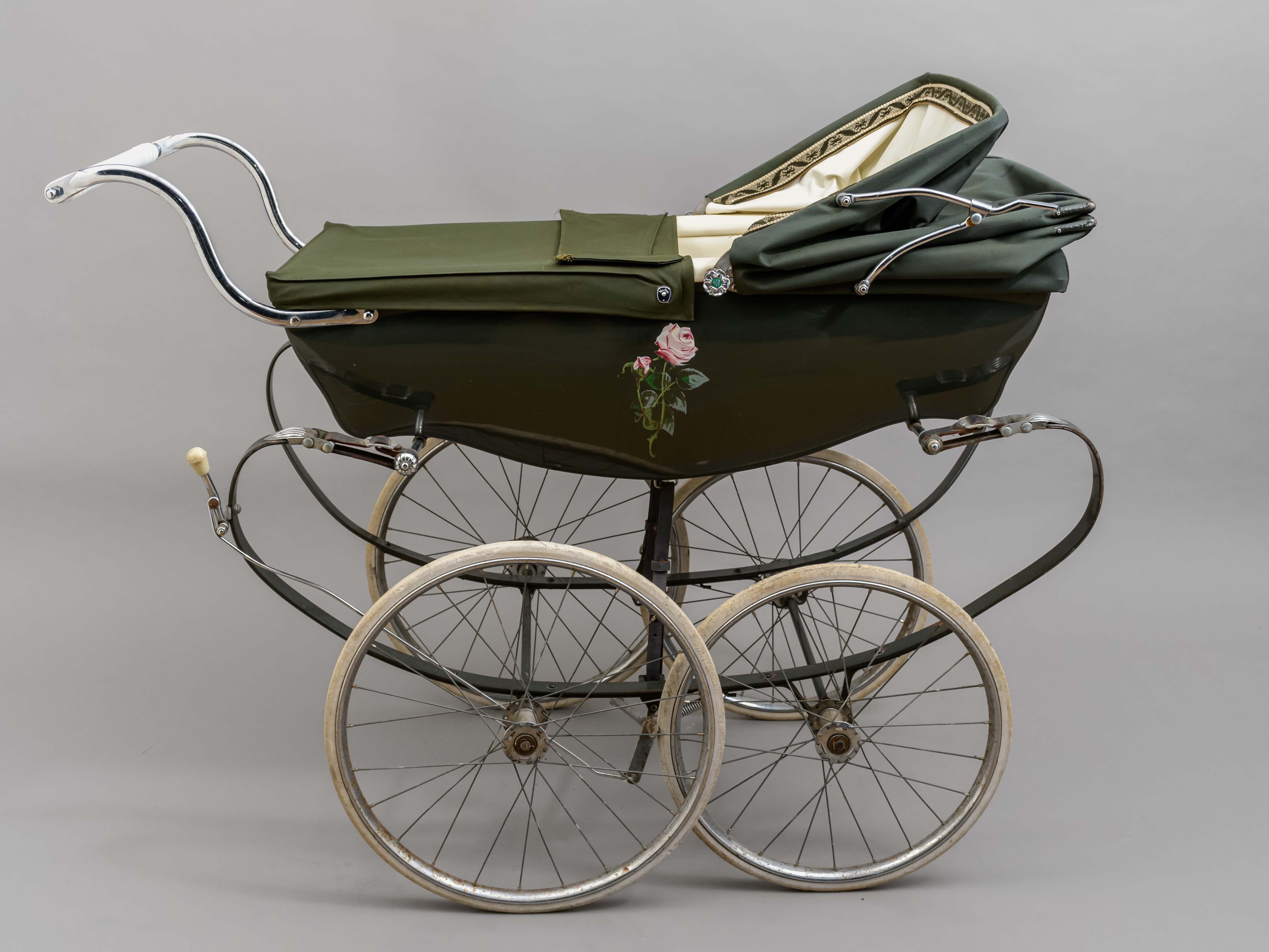
https://search.heritageburnaby.ca/link/museumartifact90986
- Repository
- Burnaby Village Museum
- Accession Code
- BV021.12.1
- Description
- Postcard: horizontal glossy colour postcard of Golden Dragon Resturant. Shows image of interior dining room with red and gold walls, laterns, tables with white table cloths. yellow chairs and a stripped black and white floor. On reservse in blue print: , "GOLDEN DRAGON" "3991 KINGSWAY" "BURNABY, B.C." "Phone: DExter 5100" "If you are not familiar with Chinese Foods let our Experts make suggestions and explain the traditions of eating that is famous throughout the world."; at bottom, "DINE and DANCE Every FRIDAY & SATURDAY"; line down centre; at right,"POST CARD" "ADDRESS"; at upper right, "STAMP"; unused; ca.1950s
- Object History
- Postcard from the Golden Dragon Resturant which served Chinese-Canadian food. Their grand opening was September 2, 1950. The community staple was known for its neon dragon sign that advertised “Chop Suey”. One side of the kitchen served Chinese foods, while another served Canadian dishes. Chinese cuisine such as rice would be served with chopsticks, while steaks, a more western dish, would be served with knife and fork. Advertisements from the resturant and meeting notices were found in local newspapers from 1950 to 1957. The establishment was not listed in the 1966 Great Vancouver Cross-Cross Directory.
- Classification
- Written Communication T&E - - Writing Media
- Object Term
- Postcard
- Marks/Labels
- Made in Canada by Grant-Mann Lithographers LTD. "Color Card" Division, Vancouver, British Columbia.
- Measurements
- 14cm wide x 9cm high
- Subjects
- Souvenirs
- Persons - Chinese Canadians
- Food Service Tools and Equipment
- Documentary Artifacts - Postcards
- Buildings - Commercial - Restaurants
- Historic Neighbourhood
- Central Park (Historic Neighbourhood)
- Planning Study Area
- Garden Village Area
Images
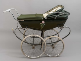
pram
https://search.heritageburnaby.ca/link/museumartifact91514
- Repository
- Burnaby Village Museum
- Accession Code
- BV021.30.1
- Description
- Green classic Wilson brand pram. There are four narrow wheels, a low-set handle bar and a moveable top canopy and cover with a patterned interior trim. The interior of the pram is white, as is the handlebar, brake handle and wheel covers. On the front end, there is a logo with the brand "Wilson" written in silver cursive, a narrow British flag and a blue tag indicating "Made in England". On either side of the pram, there is a painted pink rose. The knobs on either side of the canopy are also made to look like silver roses, with a yellow and green "W" symbol in their centre.
- Object History
- This pram belonged to George and Elaine (nee Blackstock) Burnett who lived in Burnaby on Elgin Avenue. The couple had four children, but the exact timeline of when this pram was used in unknown. The pram was made in England by the company Silver Cross, which was founded by William Wilson in 1877. It is the founder's surname from which the pram derives its name, which is found on the end of the carriage. George Burnett was employed as the foreman plumber at Oakalla Prison in Burnaby for 30 years. He was also the President of the Royal Canadian Legion Branch 83 in Burnaby. Elaine's family farmed on land in the Deer Lake Area. George and Elaine had four children: John, Derek, Louise, and Lori.
- Reference
- Pioneer Tales of Burnaby, the Corporation of the District of Burnaby: Part III: 1911-1920. Elsie Dawkins Norman. Burnaby Village Museum, Digital Reference Collection. Published 1987. (page 333)
- Classification
- Land Transportation T&E - - Human-Powered Vehicles
- Object Term
- Stroller
- Marks/Labels
- Painted pink roses; Wilson label; Made in England
- Colour
- Green
- Measurements
- height: 100 cm width: 55 cm depth: 124 cm
- Country Made
- England
- Subjects
- Transportation
- Historic Neighbourhood
- Central Park (Historic Neighbourhood)
- Planning Study Area
- Windsor Area
Images
![Prize Winning Flower displays, [September 1914] thumbnail](/media/hpo/_Data/_BVM_Images/1971/197200110020.jpg?width=280)
Prize Winning Flower displays
https://search.heritageburnaby.ca/link/museumdescription3106
- Repository
- Burnaby Village Museum
- Date
- [September 1914]
- Collection/Fonds
- Burnaby Village Museum Photograph collection
- Description Level
- Item
- Physical Description
- 1 photograph : b&w glass negative ; 16 x 20.8 cm
- Scope and Content
- Photograph of various flower displays with signs that indicate the prize they earned at the 14th Annual Central Park Agricultural Association and Farmers's Institute Exhibition. There are at least three First Prize flower displays in view and one Special Prize. This is most likely at the 14th An…
- Repository
- Burnaby Village Museum
- Collection/Fonds
- Burnaby Village Museum Photograph collection
- Description Level
- Item
- Physical Description
- 1 photograph : b&w glass negative ; 16 x 20.8 cm
- Scope and Content
- Photograph of various flower displays with signs that indicate the prize they earned at the 14th Annual Central Park Agricultural Association and Farmers's Institute Exhibition. There are at least three First Prize flower displays in view and one Special Prize. This is most likely at the 14th Annual Exhibition of the Central Park Agricultural Association and Farmers' Institute that took place from the 17th to 19th of September, 1914. An earlier catalogue record from 1988 notes that the pictures hanging from the backwall are probably children's school work from Kingsway West School. It also adds the agricultural fair was held between 1902 to 1921 in the Central Park Agricultural Hall built in 1902 in Central Park on Kingsway and the B.C.E.R. tracks.
- Geographic Access
- Central Park
- Imperial Street
- Street Address
- 3883 Imperial Street
- Accession Code
- HV972.11.20
- Access Restriction
- No restrictions
- Reproduction Restriction
- No known restrictions
- Date
- [September 1914]
- Media Type
- Photograph
- Historic Neighbourhood
- Central Park (Historic Neighbourhood)
- Planning Study Area
- Maywood Area
- Related Material
- For photographs of vegetable displays at the agricultural exhibition, see HV972.11.3 and HV972.11.17.
- Scan Resolution
- 300
- Scan Date
- 14/8/2006
- Scale
- 100
- Notes
- Title based on contents of photograph
- 1 b&w contact print accompanying negative
Images
![Prize Winning Flower displays, [September 1914] thumbnail](/media/hpo/_Data/_BVM_Images/1971/197200110020.jpg)

product package; cigar box
https://search.heritageburnaby.ca/link/museumartifact20892
- Repository
- Burnaby Village Museum
- Accession Code
- HV976.14.43
- Description
- Box, cigar
- Object History
- This cigar box came from a family who settled in Burnaby in the 1920s,on 3512 Chaffey Avenue in Burnaby. In the 1921 census, William is listed as a poultry rancher. Their children attended Inman Avenue School in Burnaby.
- Category
- 04.Tools & Equipment for Materials
- Classification
- Household Accessories - - Containers for Smoking & Tobacco
- Object Term
- Box, Cigar
- Subjects
- Personal Gear
- Historic Neighbourhood
- Central Park (Historic Neighbourhood)
- Planning Study Area
- Maywood Area
Images