Narrow Results By
Interview with Allan Nixon by Rod Fowler February 21, 1990 - Track 8
https://search.heritageburnaby.ca/link/oralhistory471
- Repository
- City of Burnaby Archives
- Date Range
- 1928-1990
- Length
- 00:07:51
- Summary
- This portion of the interview is about Al Nixon's father Basil Nixon, who was Provincial Fire Marshall, and his mother Agnes, whose father Thomas Douglas was murdered in 1934, perhaps for political reasons. He also talks about the Burquitlam neighbourhood where his Douglas grandparents lived in the…
- Repository
- City of Burnaby Archives
- Summary
- This portion of the interview is about Al Nixon's father Basil Nixon, who was Provincial Fire Marshall, and his mother Agnes, whose father Thomas Douglas was murdered in 1934, perhaps for political reasons. He also talks about the Burquitlam neighbourhood where his Douglas grandparents lived in the heritage home "Seven Gables" on Sullivan Street. He relates some childhood events, including the train wreck on Burnette Creek in 1936.
- Date Range
- 1928-1990
- Length
- 00:07:51
- Historic Neighbourhood
- Burquitlam (Historic Neighbourhood)
- Planning Study Area
- Lyndhurst Area
- Cameron Area
- Interviewer
- Fowler, Rod
- Interview Date
- February 21, 1990
- Scope and Content
- Recording is of an interview with Al Nixon, conducted by Rod Fowler. Al Nixon was one of eleven participants interviewed as part of the SFU/Burnaby Centennial Committee's oral history series titled, "Voices of Burnaby". The interview is mainly about the history and operations of the Burnaby Fire Department from its beginning in 1911 to 1990, and Al Nixon’s stories about the various ways photographs, records and artifacts about the department were collected and saved. The interview takes place while looking at photographs, but the information is clear nonetheless (His photographs have been deposited in the Burnaby Archives). Al Nixon also talks about his father's career as a firefighter, and about his Douglas grandparents and their home “The Gables” [Seven Gables] and neighbourhood in Burquitlam. To view “Narrow By” terms for each track expand this description and see “Notes”.
- Biographical Notes
- Al Nixon was born in New Westminster Feb. 8, 1936, the son of Provincial Fire Marshal Basil Nixon (1904-1975) and Agnes Douglas (1909-?). His mother’s family immigrated to Canada from Scotland in 1922 and lived in a large ca. 1900 home in Burquitlam at 9957 Sullivan Road called “Seven Gables” (recently demolished). His grandfather Thomas Douglas, a Coquitlam Councillor and Socialist, was murdered in 1934 in his North Road service station. Al Nixon began his career as a firefighter with the Burnaby Fire Department in 1957, eventually becoming Deputy Fire Chief Operations in 1987 and Fire Chief in 1991, before retiring in 1993. In the mid 1980's Al Nixon became interested in the department’s history after finding a photograph scrapbook at one of the firehalls. It was in very bad condition but he recognized its value and began a project to collect and save photographs, artifacts and stories about the Burnaby Fire Department, a 6 month project that turned into years. The photographs and information gathered by Al Nixon became part of Douglas Penn’s book “Follow that Fire: the history of the Burnaby Fire Department”.
- Total Tracks
- 8
- Total Length
- 0:43:35
- Interviewee Name
- Nixon, Al
- Interviewer Bio
- Rod Fowler returned to university as a mature student in the 1980s after working about twenty years in the field of economics and computerization in business in England, Europe and Western Canada. He graduated with a BA from SFU in both History and Sociology in 1987, his MA degree in Geography in 1989, and his PhD in Cultural Geography at SFU. He taught courses in Geography, Sociology, History and Canadian Studies at several Lower Mainland colleges, before becoming a full time member of the Geography Department at Kwantlen University College.
- Collection/Fonds
- SFU/Burnaby Centennial Committee fonds
- Transcript Available
- Transcript available
- Media Type
- Sound Recording
- Web Notes
- Interviews were digitized in 2015 allowing them to be accessible on Heritage Burnaby. The digitization project was initiated by the Community Heritage Commission with support from City of Burnaby Council.
Audio Tracks
Track eight of interview with Al Nixon
Track eight of interview with Al Nixon
https://search.heritageburnaby.ca/media/hpo/_Data/_Archives_Oral_Histories/_Unrestricted/MSS187-014/MSS187-014_Track_8.mp3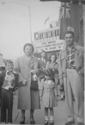
Interview with Diane Stiglish by Eric Damer December 4, 2012 - Track 2
https://search.heritageburnaby.ca/link/oralhistory410
- Repository
- City of Burnaby Archives
- Date Range
- 1947-1960
- Length
- 0:09:40
- Summary
- This portion of the recording pertains to Diane Stiglish's memories of her family's mushroom farm. Diane describes how compost was created on the farm, how the mushrooms were dealt with and what chores she was responsible for as a child. She also tells stories of inspectors coming to the farm.
- Repository
- City of Burnaby Archives
- Summary
- This portion of the recording pertains to Diane Stiglish's memories of her family's mushroom farm. Diane describes how compost was created on the farm, how the mushrooms were dealt with and what chores she was responsible for as a child. She also tells stories of inspectors coming to the farm.
- Date Range
- 1947-1960
- Photo Info
- Diane Stiglish with her parents and older brother in New Westminster, 1955. Item no. 549-067.
- Length
- 0:09:40
- Historic Neighbourhood
- Burquitlam (Historic Neighbourhood)
- Interviewer
- Damer, Eric
- Interview Date
- December 4, 2012
- Scope and Content
- Recording is an interview with Diane Stiglish conducted by Burnaby Village Museum employee Eric Damer, December 4, 2012. Major theme discussed: mushroom farming.
- Biographical Notes
- F.J. "Jack" Stiglish (originally spelt Stiglich) and his wife bought a Burnaby home in 1943 at Keswick Street, just south of the Lougheed Highway, and took up mushroom farming. By the time their daughter Diane was born five years later in New Westminster, the F.J. Stiglish mushroom farm was an established business. Mushrooms grown at the F.J. Stiglish farm were sent off to Money’s Mushrooms to be packaged and retailed. Later, mushroom growers bought out Money’s to form the Fraser Valley Mushroom Growers Co-op and nominated Jack Stiglish as their first president. Jack then entered a float in the Pacific National Exhibition (PNE) parade and set up a mushroom booth at the fair. In 1969 Jack Stiglish sold the mushroom farm and he and his wife moved next to their trailer court business just down the road. Diane’s brother Allan Stiglich (his family name returned to the original spelling) moved to Langley to open a large mushroom farm of his own which he established with the help of his father. Diane Stiglish began a career with BC Tel.
- Total Tracks
- 5
- Total Length
- 0:46:06
- Interviewee Name
- Stiglish, Diane
- Interview Location
- Burnaby Village Museum
- Interviewer Bio
- Eric Damer is a lifelong British Columbian born in Victoria, raised in Kamloops, and currently residing in Burnaby. After studying philosophy at the University of Victoria, he became interested in the educational forces that had shaped his own life. He completed master’s and doctoral degrees in educational studies at the University of British Columbia with a particular interest in the history of adult and higher education in the province. In 2012, Eric worked for the City of Burnaby as a field researcher and writer, conducting interviews for the City Archives and Museum Oral History Program.
- Collection/Fonds
- Community Heritage Commission Special Projects fonds
- Transcript Available
- None
- Media Type
- Sound Recording
Images

Audio Tracks
Track two of recording of interview with Diane Stiglish
Track two of recording of interview with Diane Stiglish
https://search.heritageburnaby.ca/media/hpo/_Data/_Archives_Oral_Histories/_Unrestricted/MSS171-026/MSS171-026_Track_2.mp3
Interview with Diane Stiglish by Eric Damer December 4, 2012 - Track 3
https://search.heritageburnaby.ca/link/oralhistory411
- Repository
- City of Burnaby Archives
- Date Range
- 1947-1965
- Length
- 0:08:59
- Summary
- This portion of the recording pertains mainly to Diane Stiglish's memories of her school days. Diane describes her family home, then goes on to discuss her school life and her after school activities. She also describes a number of her father's entrepreneurial projects.
- Repository
- City of Burnaby Archives
- Summary
- This portion of the recording pertains mainly to Diane Stiglish's memories of her school days. Diane describes her family home, then goes on to discuss her school life and her after school activities. She also describes a number of her father's entrepreneurial projects.
- Date Range
- 1947-1965
- Photo Info
- Diane Stiglish with her parents and older brother in New Westminster, 1955. Item no. 549-067.
- Length
- 0:08:59
- Subjects
- Occupations - Entrepreneurs
- Historic Neighbourhood
- Burquitlam (Historic Neighbourhood)
- Interviewer
- Damer, Eric
- Interview Date
- December 4, 2012
- Scope and Content
- Recording is an interview with Diane Stiglish conducted by Burnaby Village Museum employee Eric Damer, December 4, 2012. Major theme discussed: mushroom farming.
- Biographical Notes
- F.J. "Jack" Stiglish (originally spelt Stiglich) and his wife bought a Burnaby home in 1943 at Keswick Street, just south of the Lougheed Highway, and took up mushroom farming. By the time their daughter Diane was born five years later in New Westminster, the F.J. Stiglish mushroom farm was an established business. Mushrooms grown at the F.J. Stiglish farm were sent off to Money’s Mushrooms to be packaged and retailed. Later, mushroom growers bought out Money’s to form the Fraser Valley Mushroom Growers Co-op and nominated Jack Stiglish as their first president. Jack then entered a float in the Pacific National Exhibition (PNE) parade and set up a mushroom booth at the fair. In 1969 Jack Stiglish sold the mushroom farm and he and his wife moved next to their trailer court business just down the road. Diane’s brother Allan Stiglich (his family name returned to the original spelling) moved to Langley to open a large mushroom farm of his own which he established with the help of his father. Diane Stiglish began a career with BC Tel.
- Total Tracks
- 5
- Total Length
- 0:46:06
- Interviewee Name
- Stiglish, Diane
- Interview Location
- Burnaby Village Museum
- Interviewer Bio
- Eric Damer is a lifelong British Columbian born in Victoria, raised in Kamloops, and currently residing in Burnaby. After studying philosophy at the University of Victoria, he became interested in the educational forces that had shaped his own life. He completed master’s and doctoral degrees in educational studies at the University of British Columbia with a particular interest in the history of adult and higher education in the province. In 2012, Eric worked for the City of Burnaby as a field researcher and writer, conducting interviews for the City Archives and Museum Oral History Program.
- Collection/Fonds
- Community Heritage Commission Special Projects fonds
- Transcript Available
- None
- Media Type
- Sound Recording
Images
Audio Tracks
Track three of recording of interview with Diane Stiglish
Track three of recording of interview with Diane Stiglish
https://search.heritageburnaby.ca/media/hpo/_Data/_Archives_Oral_Histories/_Unrestricted/MSS171-026/MSS171-026_Track_3.mp3
Interview with Diane Stiglish by Eric Damer December 4, 2012 - Track 5
https://search.heritageburnaby.ca/link/oralhistory413
- Repository
- City of Burnaby Archives
- Date Range
- 1950-2012
- Length
- 0:08:57
- Summary
- This portion of the recording pertains to Diane Stiglish's memories of the neighbourhood she grew up in and the changes that have occurred there. Diane describes how her parents sold the mushroom farm and built a new home; the property later became a townhouse development. She mentions her brother …
- Repository
- City of Burnaby Archives
- Summary
- This portion of the recording pertains to Diane Stiglish's memories of the neighbourhood she grew up in and the changes that have occurred there. Diane describes how her parents sold the mushroom farm and built a new home; the property later became a townhouse development. She mentions her brother and some of their early neighbours.
- Date Range
- 1950-2012
- Photo Info
- Diane Stiglish with her parents and older brother in New Westminster, 1955. Item no. 549-067.
- Length
- 0:08:57
- Subjects
- Geographic Features - Neighbourhoods
- Historic Neighbourhood
- Burquitlam (Historic Neighbourhood)
- Interviewer
- Damer, Eric
- Interview Date
- December 4, 2012
- Scope and Content
- Recording is an interview with Diane Stiglish conducted by Burnaby Village Museum employee Eric Damer, December 4, 2012. Major theme discussed: mushroom farming.
- Biographical Notes
- F.J. "Jack" Stiglish (originally spelt Stiglich) and his wife bought a Burnaby home in 1943 at Keswick Street, just south of the Lougheed Highway, and took up mushroom farming. By the time their daughter Diane was born five years later in New Westminster, the F.J. Stiglish mushroom farm was an established business. Mushrooms grown at the F.J. Stiglish farm were sent off to Money’s Mushrooms to be packaged and retailed. Later, mushroom growers bought out Money’s to form the Fraser Valley Mushroom Growers Co-op and nominated Jack Stiglish as their first president. Jack then entered a float in the Pacific National Exhibition (PNE) parade and set up a mushroom booth at the fair. In 1969 Jack Stiglish sold the mushroom farm and he and his wife moved next to their trailer court business just down the road. Diane’s brother Allan Stiglich (his family name returned to the original spelling) moved to Langley to open a large mushroom farm of his own which he established with the help of his father. Diane Stiglish began a career with BC Tel.
- Total Tracks
- 5
- Total Length
- 0:46:06
- Interviewee Name
- Stiglish, Diane
- Interview Location
- Burnaby Village Museum
- Interviewer Bio
- Eric Damer is a lifelong British Columbian born in Victoria, raised in Kamloops, and currently residing in Burnaby. After studying philosophy at the University of Victoria, he became interested in the educational forces that had shaped his own life. He completed master’s and doctoral degrees in educational studies at the University of British Columbia with a particular interest in the history of adult and higher education in the province. In 2012, Eric worked for the City of Burnaby as a field researcher and writer, conducting interviews for the City Archives and Museum Oral History Program.
- Collection/Fonds
- Community Heritage Commission Special Projects fonds
- Transcript Available
- None
- Media Type
- Sound Recording
Images
Audio Tracks
Track five of recording of interview with Diane Stiglish
Track five of recording of interview with Diane Stiglish
https://search.heritageburnaby.ca/media/hpo/_Data/_Archives_Oral_Histories/_Unrestricted/MSS171-026/MSS171-026_Track_5.mp3
Municipality of Burnaby - Volume XVI and Volume XVII
https://search.heritageburnaby.ca/link/museumdescription8684
- Repository
- Burnaby Village Museum
- Date
- May 1927
- Collection/Fonds
- Burnaby Village Museum Map collection
- Description Level
- File
- Physical Description
- 4 plans on 4 sheets : col. lithographic prints ; 63.5 x 53.5 cm folded to 53 x 31.5 cm
- Scope and Content
- File consists of four pages of plans removed from a bound book containing a series of fire insurance plans of the Municipality of Burnaby. Page "D" is titled: "GREATER VANCOUVER B.C. / VOLUME XVI / Surveyed _ May 1927 / MUNICIPALITY OF / BURNABY / PLAN DEPT. FIRE BRANCH _ B.C. INSURANCE UNDERWRITE…
- Repository
- Burnaby Village Museum
- Collection/Fonds
- Burnaby Village Museum Map collection
- Description Level
- File
- Physical Description
- 4 plans on 4 sheets : col. lithographic prints ; 63.5 x 53.5 cm folded to 53 x 31.5 cm
- Material Details
- Scale [1:1200] and [1:6000]
- Scope and Content
- File consists of four pages of plans removed from a bound book containing a series of fire insurance plans of the Municipality of Burnaby. Page "D" is titled: "GREATER VANCOUVER B.C. / VOLUME XVI / Surveyed _ May 1927 / MUNICIPALITY OF / BURNABY / PLAN DEPT. FIRE BRANCH _ B.C. INSURANCE UNDERWRITERS ASSN." / KEY PLAN". Plans covered in this "Key Plan" are numbered 1601 to 1626, 1632 and 1651 covering District Lots: 15; 31; 100 to 102; 114; 141 to 144; 147 and 148; 209 to 214. Plan "E" is part of "GREATER VANCOUVER B.C. / VOLUME XVII / Municipality of Burnaby / May 1927" and covers plans: 1701 to 1705; 1711 to 1715; 1723 to 1727; 1729 to 1733; 1737 to 1742 and District Lots: 68 to 74; 80 to 84; 32 to 35 and 38 to 39. Plan marked "F" is a key plan titled: "GREATER VANCOUVER B.C. / VOLUME XVII / Surveyed _ May 1927 / MUNICIPALITY OF / BURNABY and covers plans: 1706 to 1710; 1716 to 1722; 1734 and 1735; 1743 to 1752 and District Lots: 42 to 44; 59; 75 to 80; 83 to 87; 89 to 93 and 130. Plan "1729" is part of "GREATER VANCOUVER B.C. / VOLUME XVII / Municipality of Burnaby / May 1927" and covers District Lots 34 and 35.
- Responsibility
- British Columbia Underwriters' Association
- Accession Code
- HV972.111.6
- Access Restriction
- No restrictions
- Reproduction Restriction
- May be restricted by third party rights
- Date
- May 1927
- Media Type
- Cartographic Material
- Historic Neighbourhood
- Barnet (Historic Neighbourhood)
- Burquitlam (Historic Neighbourhood)
- Central Park (Historic Neighbourhood)
- Burnaby Lake (Historic Neighbourhood)
- Broadview (Historic Neighbourhood)
- Planning Study Area
- Burnaby Mountain Area
- Lyndhurst Area
- Lake City Area
- Cascade-Schou Area
- Garden Village Area
- Douglas-Gilpin Area
- Oakalla Area
- Scan Resolution
- 400
- Scan Date
- 2021-11-18
- Notes
- Title based on content of plans
- See also BV987.1.70d for revised versions of plans
- Scale is measured 1 inch = 500 feet
Zoomable Images


Municipality of Burnaby - Volume XV, Volume XVI, Volume XVII, Volume XVIII
https://search.heritageburnaby.ca/link/museumdescription8685
- Repository
- Burnaby Village Museum
- Date
- May 1927
- Collection/Fonds
- Burnaby Village Museum Map collection
- Description Level
- File
- Physical Description
- 4 plans on 4 sheets : col. lithographic prints ; 63.5 x 53.5 cm folded to 53 x 31.5 cm
- Scope and Content
- File consists of four pages of plans removed from a bound book containing a series of fire insurance plans of the Municipality of Burnaby. Plan "1531" is part of "GREATER VANCOUVER B.C. / VOLUME XV / Municipality of Burnaby / May 1927" and covers District Lots: 116 and 117. Key Plan "C" is part of …
- Repository
- Burnaby Village Museum
- Collection/Fonds
- Burnaby Village Museum Map collection
- Description Level
- File
- Physical Description
- 4 plans on 4 sheets : col. lithographic prints ; 63.5 x 53.5 cm folded to 53 x 31.5 cm
- Material Details
- Scale [1:600] and [1:1200]
- Scope and Content
- File consists of four pages of plans removed from a bound book containing a series of fire insurance plans of the Municipality of Burnaby. Plan "1531" is part of "GREATER VANCOUVER B.C. / VOLUME XV / Municipality of Burnaby / May 1927" and covers District Lots: 116 and 117. Key Plan "C" is part of "GREATER VANCOUVER B.C. / VOLUME XVI / Municipality of Burnaby / May 1927" and covers plans 1623 to 1651 and District Lots: 1 and 2; 4; 6; 8; 10 to 14; 25; 27; 40; 56 to 58; 88 and 89. Plan "1738" is part of "GREATER VANCOUVER B.C. / VOLUME XVII / Municipality of Burnaby / May 1927" and covers District Lots: 34 and 35. Key plan "G" is part of "GREATER VANCOUVER B.C. / VOLUME XVIII / Municipality of Burnaby / May 1927" and covers plans: 1801 to 1813; 1823; 1824; 1833 to 1838; 1841 to 1853 and District Lots: 32; 93; 94; 97 to 99; 149; 150; 152; 155 to 159; 161 to 164.
- Responsibility
- British Columbia Underwriters' Association
- Accession Code
- HV972.111.7
- Access Restriction
- No restrictions
- Reproduction Restriction
- May be restricted by third party rights
- Date
- May 1927
- Media Type
- Cartographic Material
- Historic Neighbourhood
- Central Park (Historic Neighbourhood)
- Fraser Arm (Historic Neighbourhood)
- Alta Vista (Historic Neighbourhood)
- Broadview (Historic Neighbourhood)
- Vancouver Heights (Historic Neighbourhood)
- Burquitlam (Historic Neighbourhood)
- East Burnaby (Historic Neighbourhood)
- Edmonds (Historic Neighbourhood)
- Lozells (Historic Neighbourhood)
- Planning Study Area
- Clinton-Glenwood Area
- Marlborough Area
- Maywood Area
- Windsor Area
- Big Bend Area
- Garden Village Area
- Willingdon Heights Area
- West Central Valley Area
- Cariboo-Armstrong Area
- Lyndhurst Area
- Cameron Area
- Lake City Area
- Edmonds Area
- Second Street Area
- Sperling-Broadway Area
- Lakeview-Mayfield Area
- Scan Resolution
- 400
- Scan Date
- 2021-11-18
- Notes
- Title based on content of plans
- See also BV987.1.70d for revised versions of plans
- Scale is measured 1 inch = 500 feet
Zoomable Images

Municipality of Burnaby - Volume XV, Volume XVI, Volume XVII, Volume XVIII, May 1927
Zoom into Image
![Survey and Subdivision plans in New Westminster District Group 1 and Group 2 – Vancouver, ʷməθkʷəy̓əm (Musqueam) Indian Reserve, Burnaby, Surrey
, [1910-1911] thumbnail](/media/hpo/_Data/_BVM_Cartographic_Material/1977/1977_0093_0017_001.jpg?width=280)
Survey and Subdivision plans in New Westminster District Group 1 and Group 2 – Vancouver, ʷməθkʷəy̓əm (Musqueam) Indian Reserve, Burnaby, Surrey
https://search.heritageburnaby.ca/link/museumdescription6986
- Repository
- Burnaby Village Museum
- Date
- [1910-1911]
- Collection/Fonds
- Burnaby Village Museum Map collection
- Description Level
- File
- Physical Description
- 9 plans : 4 plans : blueprint ink on paper + 4 plans : black ink on paper + 1 plan : graphite on paper mounted on 2 sides of cardboard 76 x 102 cm
- Scope and Content
- File consists of a large board of three survey plans in New Westminster District Group 1 mounted on one side and six survey and subdivision plans of District Lot 85, New Westminster District Group 1 mounted on the other side. Side A: 1. Plan : blueprint on paper ; 30.5 x 80 cm. Title reads: "Fras…
- Repository
- Burnaby Village Museum
- Collection/Fonds
- Burnaby Village Museum Map collection
- Description Level
- File
- Physical Description
- 9 plans : 4 plans : blueprint ink on paper + 4 plans : black ink on paper + 1 plan : graphite on paper mounted on 2 sides of cardboard 76 x 102 cm
- Material Details
- Scales vary (One chain equals 792 inches)
- Indexed number on tape on edge of board reads "17"
- Scope and Content
- File consists of a large board of three survey plans in New Westminster District Group 1 mounted on one side and six survey and subdivision plans of District Lot 85, New Westminster District Group 1 mounted on the other side. Side A: 1. Plan : blueprint on paper ; 30.5 x 80 cm. Title reads: "Fraser River Bridge / Plan of South Approach". Plan covers area of land north of the Fraser River and Great Northern Railway with approach for a bridge running through the "ʷməθkʷəy̓əm (Musqueam) Indian Reserve" (ʷməθkʷəy̓əm (Musqueam) First Nation) and lots marked as Dominion Government and the east half of Lot 2 identified as "C. F. Brown" "Plan 851". Plan is identified as "Plan 851 / traced / Mar. 17, 1911". (Geographic location in Vancouver) Scale: 100 feet = 1 inch, Signed by Albert J. Hill / P.L.S." 2. Plan : blueprint on paper ; 36.5 x 35 cm (no title). Includes three plans of lots on the east and west sides of North Road. Note on bottom of blueprint reads: "I.E.B. McKay Surveyor General - hereby certify / that this is a correct tracing from the field / notes of the Royal Engineers on file in the / Lands Department / E.B. McKay (signature) / Surveyor General / Victoria B.C. April 11th 1911" . Plan in top left titled "Page 11 / Vol. 1. / R.E. Notes" covers District Lots east of North Road including Lot 5, Lot 7, Lot 41, Lot 9 and Lot 107 in Coquitlam. Plan in top right corner titled "Page 17 / Vol. 1. / R.E. Notes" covers District Lots east of North Road including Lot 104, Lot 54, Lot 105, Lot 55, Lot 106, Lot 9 and Lot 107 in Coquitlam and Port Moody. Plan in lower left corner titled "Page 15 / Vol. 1 / R.E. Notes" covers District Lots west of North Road including Lot 147, Lot 148, Lot 100, Lot 15 in Burnaby. 3. Plan : blue print on paper ; 29.5 x 41.5 cm. (no formal title). Plan of the North 1/2 of Section 18. Plan covers area in the "North 1/2 of Sec.18 B.5 N RGE 1 W" and "Sec. 18 B.5 N. RGE 1 W" bordered by Section 7, Section 13, Section 17 and Section 19. Bon Accord Road runs through Sec. 18. The plan is signed by surveryor "I.H. Neville Smith... C.E.B.C.L.S. / Mar. 26th 1910" and signed by "Ludwig Pillath". (Geographic location: Surrey) Side B: 1. Plan : blueprint on paper ; 43.5 x 49.5 cm. Title reads: "Plan / of Subdivision / of a Portion / of / Lot 85 / Group One / New Westminster District. Plan covers portion of land east of Deer Lake and Pole Line Road (Sperling Avenue) and south of Hastings Road in District Lot 85 in Burnaby with section 4 and a portion of section 2 coloured in red. Plan is signed by "Albert J. Hill, B.C.L.S." Plan is initialed by: "RB" [sic] (in blue pencil crayon) Scale: 4 chains = 1 inch 2. Plaln : black black ink on linen ; 39 x 37 cm. Title reads: "L.C. Hill's Property, / Burnaby". Plan covers a triangular portion of land east of Pole Line Road (Sperling Avenue) and south of Hastings Road in District Lot 85 in Burnaby. Plan is intitaled by "RB" [sic] (in blue pencil crayon). Scale: 3 chains = 1 mile 3. Plan : graphite on paper ; 23 x 17 cm. Title reads: "Portion of Lot 85 / Gr.1". Plan covers portion of land north east of Deer Lake and west of Pole Line Road (now Sperling Avenue) in District Lot 85 in Burnaby. Plan is stamped in red ink: "Albert J. Hill, Civil Engineer". Plan is initialed by: "RB" [sic] (in blue pencil crayon). Scale: 1 chain = 1 inch 4. Plan : black ink on linen ; 16 x 19 cm. Title reads: "Lot 85". Plan covers the intersection of Pole Line Road (Sperling Avenue) and Hastings Road at the north west section of District Lot 79 and District Lot 85 in Burnaby. Plan is stamped: "A.J. Hill, Civil Engineer" with identitifed in blue pencil crayon. 5. Plan : black ink on paper ; 28.5 x 37 cm. (no formal title) Plan covers an area of land, west of Pole Line Road (Sperling Avenue) and south of Deer Lake in District Lot 85 in Burnaby. Plan is initialed by: "RB" [sic] (in blue pencil crayon) 6. Plan : black ink on paper ; 21 x 34 cm (no formal title). Plan covers an area of land, west of Pole Line Road (Sperling Avenue) and south of Deer Lake in District Lot 85 in Burnaby. Plan is initialed by: "RB" [sic] (in blue pencil crayon)
- Accession Code
- HV977.93.17
- Access Restriction
- No restrictions
- Reproduction Restriction
- No known restrictions
- Date
- [1910-1911]
- Media Type
- Cartographic Material
- Historic Neighbourhood
- Burnaby Lake (Historic Neighbourhood)
- Burquitlam (Historic Neighbourhood)
- Planning Study Area
- Morley-Buckingham Area
- Douglas-Gilpin Area
- Scan Resolution
- 600
- Scan Date
- 2023-06-26
- Notes
- Title based on contents of file
- Scale is measured in chains and feet. (One chain equals 792 inches).
- The term "Lot" also refers to a "District Lot”
- Some plans are stamped: "Albert J. Hill, Civil Engineer / and / Provincial Land Surveyor, / New Westminster, / B.C." and intialed: "RB" [sic]
Zoomable Images
![Survey and Subdivision plans in New Westminster District Group 1 and Group 2 – Vancouver, ʷməθkʷəy̓əm (Musqueam) Indian Reserve, Burnaby, Surrey
, [1910-1911] thumbnail](/media/hpo/_Data/_BVM_Cartographic_Material/1977/1977_0093_0017_003_seadragon/1977_0093_0017_003.jpg?w=280)
Survey and Subdivision plans in New Westminster District Group 1 and Group 2 – Vancouver, ʷməθkʷəy̓əm (Musqueam) Indian Reserve, Burnaby, Surrey , [1910-1911]
Zoom into Image