Narrow Results By
Subject
- Aerial Photographs 4
- Agricultural Tools and Equipment 2
- Agriculture - Farms 6
- Animals - Dogs 1
- Building - Agricultural 1
- Buildings - Residential - Houses 1
- Buildings - Schools 3
- Events - Openings 1
- First Nations reserves - British Columbia 1
- Geographic Features - Neighbourhoods 1
- Geographic Features - Roads 1
- Indigenous peoples - Indian Territory 1

Burquitlam Neighbourhood
https://search.heritageburnaby.ca/link/landmark757
- Repository
- Burnaby Heritage Planning
- Associated Dates
- 1905-1924
- Heritage Value
- In 1921, the pamphlet "Beautiful Burnaby" was produced and it described the Burquitlam neighbourhood as such: "No part of Burnaby has more consistently laboured to advance its prosperity than Burquitlam. Enterprise and intelligence has hewn homes from the forest and developed land into highly productive gardens and poultry ranches. Burquitlam is the growing suburb to the north of the City of New Westminster. It is reached by the Sapperton carline direct from Edmonds being only a few minutes ride from New Westminster market. It is also served by the B.C.E.R. Burnaby Lake line and adjoins on the best golf links in Greater Vancouver."
- Historic Neighbourhood
- Burquitlam (Historic Neighbourhood)
- Planning Study Area
- Cameron Area
- Lyndhurst Area
Images


Cameron Elementary School
https://search.heritageburnaby.ca/link/landmark833
- Repository
- Burnaby Heritage Planning
- Geographic Access
- Erickson Drive
- Associated Dates
- 1965
- Heritage Value
- The increasing density of housing around the Lougheed Shopping Centre area resulted in a spike in enrolment at Lyndhurst Elementary School. As a result, in 1965, Cameron Road Elementary was built to alleviate overcrowding issues. The school opened with 151 pupils. The school was expanded in 1969 when three classrooms were added and again in 1971 when eights more rooms and a library were built.
- Historic Neighbourhood
- Burquitlam (Historic Neighbourhood)
- Planning Study Area
- Cameron Area
- Street Address
- 9540 Erickson Drive
- Street View URL
- Google Maps Street View
Images


Cameron Neighbourhood
https://search.heritageburnaby.ca/link/landmark824
- Repository
- Burnaby Heritage Planning
- Associated Dates
- 1955-2008
- Heritage Value
- The Cameron Neighbourhood falls within the Lougheed Town Centre area - one of four Town Centres in Burnaby. The Cameron Neighbourhood - while containing significant high-density residential components - is also home to the Town Centre's office and commercial core. The Lougheed Mall is situated in this neighbourhood, which is served by the Millennium Line SkyTrain.
- Historic Neighbourhood
- Burquitlam (Historic Neighbourhood)
- Planning Study Area
- Cameron Area
Images


Lyndhurst Neighbourhood
https://search.heritageburnaby.ca/link/landmark823
- Repository
- Burnaby Heritage Planning
- Associated Dates
- 1955-2008
- Heritage Value
- The Lyndhurst Neighbourhood falls within the Lougheed Town Centre area - one of four Town Centres in Burnaby. The Lyndhurst Neighbourhood accounts for a significant portion of the residential component of the Town Centre. To the east of Stoney Creek Park, lies the Sullivan Heights single family subdivision which was built in the 1950s. To the west of the park, is a higher-density residential area consisting of multi-family buildings that were developed after 1974.
- Historic Neighbourhood
- Burquitlam (Historic Neighbourhood)
- Planning Study Area
- Lyndhurst Area
Images


St. Stephen's Anglican Church
https://search.heritageburnaby.ca/link/landmark765
- Repository
- Burnaby Heritage Planning
- Geographic Access
- Cameron Street
- Associated Dates
- 1913
- Heritage Value
- The site of St. Stephen's Anglican Church is one of the historic landmarks of old Burquitlam. Originally this was part of the Alexander and Ethel Evans farm, Saint Phillians. Initial services for the church were held in the Evans home and later in the Burquitlam school. Alexander Evans donated this site to the Anglican Church in trust with the wish that it become a future church and consecrated ground for a family burial plot. In 1913, the parish raised the funds to build the first church. St. Stephen's was consecrated by Bishop de Pencier on September 28, 1913.
- Historic Neighbourhood
- Burquitlam (Historic Neighbourhood)
- Planning Study Area
- Lyndhurst Area
- Street Address
- 9887 Cameron Street
- Street View URL
- Google Maps Street View
Images

Aerial photograph of Burnaby
https://search.heritageburnaby.ca/link/archivedescription84911
- Repository
- City of Burnaby Archives
- Date
- 1963
- Collection/Fonds
- Allan Amundsen collection
- Description Level
- Item
- Physical Description
- 1 photograph : b&w ; 22.5 x 22.5 cm
- Scope and Content
- Aerial photograph of Burnaby with Lougheed Highway running west to east through the middle of the photograph and the Trans Canada Highway in the lower left segment.
- Repository
- City of Burnaby Archives
- Date
- 1963
- Collection/Fonds
- Allan Amundsen collection
- Physical Description
- 1 photograph : b&w ; 22.5 x 22.5 cm
- Description Level
- Item
- Record No.
- 561-029
- Access Restriction
- In Archives only
- Reproduction Restriction
- No reproduction permitted
- Accession Number
- 2014-08
- Scope and Content
- Aerial photograph of Burnaby with Lougheed Highway running west to east through the middle of the photograph and the Trans Canada Highway in the lower left segment.
- Subjects
- Aerial Photographs
- Media Type
- Photograph
- Photographer
- Province of British Columbia
- Notes
- Title based on contents of photograph
- This photo is indentified as BC5062:22 and connects with B.C. air photograph BC5062:23 to the west and B.C. air photograph BC5062:21
- Historic Neighbourhood
- Lozells (Historic Neighbourhood)
- Burquitlam (Historic Neighbourhood)
- Planning Study Area
- Lake City Area
- Government Road Area
- Burnaby Lake Area
- Lyndhurst Area
- Cariboo-Armstrong Area
Aerial photograph of Burnaby and Coquitlam
https://search.heritageburnaby.ca/link/archivedescription84912
- Repository
- City of Burnaby Archives
- Date
- 1963
- Collection/Fonds
- Allan Amundsen collection
- Description Level
- Item
- Physical Description
- 1 photograph : b&w ; 22.5 x 22.5 cm
- Scope and Content
- Aerial photograph of Burnaby and Coquitlam with North Road running through the centre.
- Repository
- City of Burnaby Archives
- Date
- 1963
- Collection/Fonds
- Allan Amundsen collection
- Physical Description
- 1 photograph : b&w ; 22.5 x 22.5 cm
- Description Level
- Item
- Record No.
- 561-030
- Access Restriction
- In Archives only
- Reproduction Restriction
- No reproduction permitted
- Accession Number
- 2014-08
- Scope and Content
- Aerial photograph of Burnaby and Coquitlam with North Road running through the centre.
- Subjects
- Aerial Photographs
- Media Type
- Photograph
- Photographer
- Province of British Columbia
- Notes
- Title based on contents of photograph
- This photo is indentified as BC5062:21 and connects with B.C. air photograph BC5062:22 to the west and BC5062:70 to the east
- Historic Neighbourhood
- Burquitlam (Historic Neighbourhood)
- Planning Study Area
- Cameron Area
- Lyndhurst Area
- Cariboo-Armstrong Area
Aerial photograph of Burnaby Mountain and Port Moody
https://search.heritageburnaby.ca/link/archivedescription84895
- Repository
- City of Burnaby Archives
- Date
- 1963
- Collection/Fonds
- Allan Amundsen collection
- Description Level
- Item
- Physical Description
- 1 photograph : b&w ; 22.5 x 22.5 cm
- Scope and Content
- Aerial photograph of Burnaby Mountain, north of Broadway .
- Repository
- City of Burnaby Archives
- Date
- 1963
- Collection/Fonds
- Allan Amundsen collection
- Physical Description
- 1 photograph : b&w ; 22.5 x 22.5 cm
- Description Level
- Item
- Record No.
- 561-017
- Access Restriction
- In Archives only
- Reproduction Restriction
- No reproduction permitted
- Accession Number
- 2014-08
- Scope and Content
- Aerial photograph of Burnaby Mountain, north of Broadway .
- Subjects
- Aerial Photographs
- Media Type
- Photograph
- Photographer
- Province of British Columbia
- Notes
- Title based on contents of photograph
- This photo is indentified as BC5061:122 and connects with B.C. air photograph BC5061:121 to the west and BC5061:123 to the east
- Geographic Access
- Burnaby Mountain Conservation Area
- Historic Neighbourhood
- Burquitlam (Historic Neighbourhood)
- Planning Study Area
- Lake City Area
- Burnaby Mountain Area
- Lyndhurst Area
Aerial photograph of Burnaby Mountain and Port Moody
https://search.heritageburnaby.ca/link/archivedescription84897
- Repository
- City of Burnaby Archives
- Date
- 1963
- Collection/Fonds
- Allan Amundsen collection
- Description Level
- Item
- Physical Description
- 1 photograph : b&w ; 22.5 x 22.5 cm
- Scope and Content
- Aerial photograph of North Road and Burnaby Mountain to the west and Port Moody to the east, north of Broadway (Como Lake Avenue).
- Repository
- City of Burnaby Archives
- Date
- 1963
- Collection/Fonds
- Allan Amundsen collection
- Physical Description
- 1 photograph : b&w ; 22.5 x 22.5 cm
- Description Level
- Item
- Record No.
- 561-018
- Access Restriction
- In Archives only
- Reproduction Restriction
- No reproduction permitted
- Accession Number
- 2014-08
- Scope and Content
- Aerial photograph of North Road and Burnaby Mountain to the west and Port Moody to the east, north of Broadway (Como Lake Avenue).
- Subjects
- Aerial Photographs
- Media Type
- Photograph
- Photographer
- Province of British Columbia
- Notes
- Title based on contents of photograph
- This photo is indentified as BC5061:123 and connects with B.C. air photograph BC5061:122 to the west and BC5061:124 to the east
- Geographic Access
- Burnaby Mountain Conservation Area
- Historic Neighbourhood
- Burquitlam (Historic Neighbourhood)
- Planning Study Area
- Lake City Area
- Burnaby Mountain Area
![Garage and mushroom house, [before 1969] (date of original), digitally copied 2013 thumbnail](/media/hpo/_Data/_Archives_Images/_Unrestricted/550/552-006.jpg?width=280)
Garage and mushroom house
https://search.heritageburnaby.ca/link/archivedescription77192
- Repository
- City of Burnaby Archives
- Date
- [before 1969] (date of original), digitally copied 2013
- Collection/Fonds
- Stiglish family fonds
- Description Level
- Item
- Physical Description
- 1 photograph : b&w copy-print ; 9 x 9 cm
- Scope and Content
- Photograph of the garage where Jack Stiglish repaired machinery and housed his tools, and the mushroom house beside it. A sign propped up between the two buildings reads "manure" with an arrow pointing to the right.
- Repository
- City of Burnaby Archives
- Date
- [before 1969] (date of original), digitally copied 2013
- Collection/Fonds
- Stiglish family fonds
- Physical Description
- 1 photograph : b&w copy-print ; 9 x 9 cm
- Description Level
- Item
- Record No.
- 552-006
- Access Restriction
- No restrictions
- Reproduction Restriction
- May be restricted by third party rights
- Accession Number
- 2013-07
- Scope and Content
- Photograph of the garage where Jack Stiglish repaired machinery and housed his tools, and the mushroom house beside it. A sign propped up between the two buildings reads "manure" with an arrow pointing to the right.
- Names
- Stiglish, F.J. "Jack"
- Media Type
- Photograph
- Notes
- Title based on contents of photograph
- Note in blue ink on verso of photograph reads: "view of father's garage where his tools were + he repaired the machinery / sign saying bags of manure this way / mushroom house next to garage"
- Original spelling of surname was "Stiglich"
- Geographic Access
- Keswick Avenue
- Street Address
- 3782 Keswick Avenue
- Historic Neighbourhood
- Burquitlam (Historic Neighbourhood)
- Planning Study Area
- Cameron Area
Images
![Garage and mushroom house, [before 1969] (date of original), digitally copied 2013 thumbnail](/media/hpo/_Data/_Archives_Images/_Unrestricted/550/552-006.jpg)
![Hamilton Road School, [between 1911 and 1919] thumbnail](/media/hpo/_Data/_Archives_Images/_Unrestricted/316/325-036.jpg?width=280)
Hamilton Road School
https://search.heritageburnaby.ca/link/archivedescription37164
- Repository
- City of Burnaby Archives
- Date
- [between 1911 and 1919]
- Collection/Fonds
- Burnaby Historical Society fonds
- Description Level
- Item
- Physical Description
- 1 photograph : b&w ; 8 x 12.5 cm print
- Scope and Content
- Photograph of Hamilton Road School taken from a distance.
- Repository
- City of Burnaby Archives
- Date
- [between 1911 and 1919]
- Collection/Fonds
- Burnaby Historical Society fonds
- Subseries
- Disney family subseries
- Physical Description
- 1 photograph : b&w ; 8 x 12.5 cm print
- Description Level
- Item
- Record No.
- 325-036
- Access Restriction
- No restrictions
- Reproduction Restriction
- No known restrictions
- Accession Number
- BHS1996-04
- Scope and Content
- Photograph of Hamilton Road School taken from a distance.
- Subjects
- Buildings - Schools
- Names
- Hamilton Road School
- Media Type
- Photograph
- Photographer
- Disney, John Harold "Jack"
- Notes
- Title based on contents of photograph
- Geographic Access
- Lyndhurst Street
- Historic Neighbourhood
- Burquitlam (Historic Neighbourhood)
- Planning Study Area
- Sperling-Broadway Area
Images
![Hamilton Road School, [between 1911 and 1919] thumbnail](/media/hpo/_Data/_Archives_Images/_Unrestricted/316/325-036.jpg)

Hamilton Road School site
https://search.heritageburnaby.ca/link/museumdescription11139
- Repository
- Burnaby Village Museum
- Date
- April 27, 1915
- Collection/Fonds
- Ronald G. Scobbie collection
- Description Level
- Item
- Physical Description
- 1 survey plan : blueprint on paper ; 56 x 54 cm
- Scope and Content
- Survey plan of "Hamilton Road School Site / Burnaby Municipality" "Being the westerly 2 acres of Block 2 of the subd. of a portion of Lot 8, Group 1"; "New Westminster District”.
- Repository
- Burnaby Village Museum
- Collection/Fonds
- Ronald G. Scobbie collection
- Description Level
- Item
- Physical Description
- 1 survey plan : blueprint on paper ; 56 x 54 cm
- Material Details
- Scale 40 feet = 1 inch
- Scope and Content
- Survey plan of "Hamilton Road School Site / Burnaby Municipality" "Being the westerly 2 acres of Block 2 of the subd. of a portion of Lot 8, Group 1"; "New Westminster District”.
- Creator
- Burnett, Geoffrey K.
- Subjects
- Buildings - Schools
- Names
- Hamilton Road School
- Responsibility
- Burnett & McGugan, Engineers and Surveyors
- Geographic Access
- Lyndhurst Street
- Accession Code
- BV003.83.18
- Access Restriction
- No restrictions
- Reproduction Restriction
- No known restrictions
- Date
- April 27, 1915
- Media Type
- Cartographic Material
- Historic Neighbourhood
- Burquitlam (Historic Neighbourhood)
- Planning Study Area
- Sperling-Broadway Area
- Scan Resolution
- 440
- Scan Date
- 22-Dec-2020
- Scale
- 100
- Notes
- Title based on contents of plan
- handwritten on back, "1752" and mathematical calculations
- Oath on plan reads: "I, Geoffrey K. Burnett...and did person- ally superintend the survey..." "...completed on the 27th day of April 1915"; signed by Geoffrey K. Burnett, notary illegible, sworn "...27th day of April 1915" "Burnett and McGugan" "B.C. Land Surveyors Etc. New Westminster, B.C."
Images

Interview with Allan Nixon by Rod Fowler February 21, 1990 - Track 8
https://search.heritageburnaby.ca/link/oralhistory471
- Repository
- City of Burnaby Archives
- Date Range
- 1928-1990
- Length
- 00:07:51
- Summary
- This portion of the interview is about Al Nixon's father Basil Nixon, who was Provincial Fire Marshall, and his mother Agnes, whose father Thomas Douglas was murdered in 1934, perhaps for political reasons. He also talks about the Burquitlam neighbourhood where his Douglas grandparents lived in the…
- Repository
- City of Burnaby Archives
- Summary
- This portion of the interview is about Al Nixon's father Basil Nixon, who was Provincial Fire Marshall, and his mother Agnes, whose father Thomas Douglas was murdered in 1934, perhaps for political reasons. He also talks about the Burquitlam neighbourhood where his Douglas grandparents lived in the heritage home "Seven Gables" on Sullivan Street. He relates some childhood events, including the train wreck on Burnette Creek in 1936.
- Date Range
- 1928-1990
- Length
- 00:07:51
- Historic Neighbourhood
- Burquitlam (Historic Neighbourhood)
- Planning Study Area
- Lyndhurst Area
- Cameron Area
- Interviewer
- Fowler, Rod
- Interview Date
- February 21, 1990
- Scope and Content
- Recording is of an interview with Al Nixon, conducted by Rod Fowler. Al Nixon was one of eleven participants interviewed as part of the SFU/Burnaby Centennial Committee's oral history series titled, "Voices of Burnaby". The interview is mainly about the history and operations of the Burnaby Fire Department from its beginning in 1911 to 1990, and Al Nixon’s stories about the various ways photographs, records and artifacts about the department were collected and saved. The interview takes place while looking at photographs, but the information is clear nonetheless (His photographs have been deposited in the Burnaby Archives). Al Nixon also talks about his father's career as a firefighter, and about his Douglas grandparents and their home “The Gables” [Seven Gables] and neighbourhood in Burquitlam. To view “Narrow By” terms for each track expand this description and see “Notes”.
- Biographical Notes
- Al Nixon was born in New Westminster Feb. 8, 1936, the son of Provincial Fire Marshal Basil Nixon (1904-1975) and Agnes Douglas (1909-?). His mother’s family immigrated to Canada from Scotland in 1922 and lived in a large ca. 1900 home in Burquitlam at 9957 Sullivan Road called “Seven Gables” (recently demolished). His grandfather Thomas Douglas, a Coquitlam Councillor and Socialist, was murdered in 1934 in his North Road service station. Al Nixon began his career as a firefighter with the Burnaby Fire Department in 1957, eventually becoming Deputy Fire Chief Operations in 1987 and Fire Chief in 1991, before retiring in 1993. In the mid 1980's Al Nixon became interested in the department’s history after finding a photograph scrapbook at one of the firehalls. It was in very bad condition but he recognized its value and began a project to collect and save photographs, artifacts and stories about the Burnaby Fire Department, a 6 month project that turned into years. The photographs and information gathered by Al Nixon became part of Douglas Penn’s book “Follow that Fire: the history of the Burnaby Fire Department”.
- Total Tracks
- 8
- Total Length
- 0:43:35
- Interviewee Name
- Nixon, Al
- Interviewer Bio
- Rod Fowler returned to university as a mature student in the 1980s after working about twenty years in the field of economics and computerization in business in England, Europe and Western Canada. He graduated with a BA from SFU in both History and Sociology in 1987, his MA degree in Geography in 1989, and his PhD in Cultural Geography at SFU. He taught courses in Geography, Sociology, History and Canadian Studies at several Lower Mainland colleges, before becoming a full time member of the Geography Department at Kwantlen University College.
- Collection/Fonds
- SFU/Burnaby Centennial Committee fonds
- Transcript Available
- Transcript available
- Media Type
- Sound Recording
- Web Notes
- Interviews were digitized in 2015 allowing them to be accessible on Heritage Burnaby. The digitization project was initiated by the Community Heritage Commission with support from City of Burnaby Council.
Audio Tracks
Track eight of interview with Al Nixon
Track eight of interview with Al Nixon
https://search.heritageburnaby.ca/media/hpo/_Data/_Archives_Oral_Histories/_Unrestricted/MSS187-014/MSS187-014_Track_8.mp3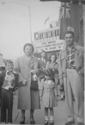
Interview with Diane Stiglish by Eric Damer December 4, 2012 - Track 2
https://search.heritageburnaby.ca/link/oralhistory410
- Repository
- City of Burnaby Archives
- Date Range
- 1947-1960
- Length
- 0:09:40
- Summary
- This portion of the recording pertains to Diane Stiglish's memories of her family's mushroom farm. Diane describes how compost was created on the farm, how the mushrooms were dealt with and what chores she was responsible for as a child. She also tells stories of inspectors coming to the farm.
- Repository
- City of Burnaby Archives
- Summary
- This portion of the recording pertains to Diane Stiglish's memories of her family's mushroom farm. Diane describes how compost was created on the farm, how the mushrooms were dealt with and what chores she was responsible for as a child. She also tells stories of inspectors coming to the farm.
- Date Range
- 1947-1960
- Photo Info
- Diane Stiglish with her parents and older brother in New Westminster, 1955. Item no. 549-067.
- Length
- 0:09:40
- Historic Neighbourhood
- Burquitlam (Historic Neighbourhood)
- Interviewer
- Damer, Eric
- Interview Date
- December 4, 2012
- Scope and Content
- Recording is an interview with Diane Stiglish conducted by Burnaby Village Museum employee Eric Damer, December 4, 2012. Major theme discussed: mushroom farming.
- Biographical Notes
- F.J. "Jack" Stiglish (originally spelt Stiglich) and his wife bought a Burnaby home in 1943 at Keswick Street, just south of the Lougheed Highway, and took up mushroom farming. By the time their daughter Diane was born five years later in New Westminster, the F.J. Stiglish mushroom farm was an established business. Mushrooms grown at the F.J. Stiglish farm were sent off to Money’s Mushrooms to be packaged and retailed. Later, mushroom growers bought out Money’s to form the Fraser Valley Mushroom Growers Co-op and nominated Jack Stiglish as their first president. Jack then entered a float in the Pacific National Exhibition (PNE) parade and set up a mushroom booth at the fair. In 1969 Jack Stiglish sold the mushroom farm and he and his wife moved next to their trailer court business just down the road. Diane’s brother Allan Stiglich (his family name returned to the original spelling) moved to Langley to open a large mushroom farm of his own which he established with the help of his father. Diane Stiglish began a career with BC Tel.
- Total Tracks
- 5
- Total Length
- 0:46:06
- Interviewee Name
- Stiglish, Diane
- Interview Location
- Burnaby Village Museum
- Interviewer Bio
- Eric Damer is a lifelong British Columbian born in Victoria, raised in Kamloops, and currently residing in Burnaby. After studying philosophy at the University of Victoria, he became interested in the educational forces that had shaped his own life. He completed master’s and doctoral degrees in educational studies at the University of British Columbia with a particular interest in the history of adult and higher education in the province. In 2012, Eric worked for the City of Burnaby as a field researcher and writer, conducting interviews for the City Archives and Museum Oral History Program.
- Collection/Fonds
- Community Heritage Commission Special Projects fonds
- Transcript Available
- None
- Media Type
- Sound Recording
Images

Audio Tracks
Track two of recording of interview with Diane Stiglish
Track two of recording of interview with Diane Stiglish
https://search.heritageburnaby.ca/media/hpo/_Data/_Archives_Oral_Histories/_Unrestricted/MSS171-026/MSS171-026_Track_2.mp3
Interview with Diane Stiglish by Eric Damer December 4, 2012 - Track 3
https://search.heritageburnaby.ca/link/oralhistory411
- Repository
- City of Burnaby Archives
- Date Range
- 1947-1965
- Length
- 0:08:59
- Summary
- This portion of the recording pertains mainly to Diane Stiglish's memories of her school days. Diane describes her family home, then goes on to discuss her school life and her after school activities. She also describes a number of her father's entrepreneurial projects.
- Repository
- City of Burnaby Archives
- Summary
- This portion of the recording pertains mainly to Diane Stiglish's memories of her school days. Diane describes her family home, then goes on to discuss her school life and her after school activities. She also describes a number of her father's entrepreneurial projects.
- Date Range
- 1947-1965
- Photo Info
- Diane Stiglish with her parents and older brother in New Westminster, 1955. Item no. 549-067.
- Length
- 0:08:59
- Subjects
- Occupations - Entrepreneurs
- Historic Neighbourhood
- Burquitlam (Historic Neighbourhood)
- Interviewer
- Damer, Eric
- Interview Date
- December 4, 2012
- Scope and Content
- Recording is an interview with Diane Stiglish conducted by Burnaby Village Museum employee Eric Damer, December 4, 2012. Major theme discussed: mushroom farming.
- Biographical Notes
- F.J. "Jack" Stiglish (originally spelt Stiglich) and his wife bought a Burnaby home in 1943 at Keswick Street, just south of the Lougheed Highway, and took up mushroom farming. By the time their daughter Diane was born five years later in New Westminster, the F.J. Stiglish mushroom farm was an established business. Mushrooms grown at the F.J. Stiglish farm were sent off to Money’s Mushrooms to be packaged and retailed. Later, mushroom growers bought out Money’s to form the Fraser Valley Mushroom Growers Co-op and nominated Jack Stiglish as their first president. Jack then entered a float in the Pacific National Exhibition (PNE) parade and set up a mushroom booth at the fair. In 1969 Jack Stiglish sold the mushroom farm and he and his wife moved next to their trailer court business just down the road. Diane’s brother Allan Stiglich (his family name returned to the original spelling) moved to Langley to open a large mushroom farm of his own which he established with the help of his father. Diane Stiglish began a career with BC Tel.
- Total Tracks
- 5
- Total Length
- 0:46:06
- Interviewee Name
- Stiglish, Diane
- Interview Location
- Burnaby Village Museum
- Interviewer Bio
- Eric Damer is a lifelong British Columbian born in Victoria, raised in Kamloops, and currently residing in Burnaby. After studying philosophy at the University of Victoria, he became interested in the educational forces that had shaped his own life. He completed master’s and doctoral degrees in educational studies at the University of British Columbia with a particular interest in the history of adult and higher education in the province. In 2012, Eric worked for the City of Burnaby as a field researcher and writer, conducting interviews for the City Archives and Museum Oral History Program.
- Collection/Fonds
- Community Heritage Commission Special Projects fonds
- Transcript Available
- None
- Media Type
- Sound Recording
Images
Audio Tracks
Track three of recording of interview with Diane Stiglish
Track three of recording of interview with Diane Stiglish
https://search.heritageburnaby.ca/media/hpo/_Data/_Archives_Oral_Histories/_Unrestricted/MSS171-026/MSS171-026_Track_3.mp3
Interview with Diane Stiglish by Eric Damer December 4, 2012 - Track 5
https://search.heritageburnaby.ca/link/oralhistory413
- Repository
- City of Burnaby Archives
- Date Range
- 1950-2012
- Length
- 0:08:57
- Summary
- This portion of the recording pertains to Diane Stiglish's memories of the neighbourhood she grew up in and the changes that have occurred there. Diane describes how her parents sold the mushroom farm and built a new home; the property later became a townhouse development. She mentions her brother …
- Repository
- City of Burnaby Archives
- Summary
- This portion of the recording pertains to Diane Stiglish's memories of the neighbourhood she grew up in and the changes that have occurred there. Diane describes how her parents sold the mushroom farm and built a new home; the property later became a townhouse development. She mentions her brother and some of their early neighbours.
- Date Range
- 1950-2012
- Photo Info
- Diane Stiglish with her parents and older brother in New Westminster, 1955. Item no. 549-067.
- Length
- 0:08:57
- Subjects
- Geographic Features - Neighbourhoods
- Historic Neighbourhood
- Burquitlam (Historic Neighbourhood)
- Interviewer
- Damer, Eric
- Interview Date
- December 4, 2012
- Scope and Content
- Recording is an interview with Diane Stiglish conducted by Burnaby Village Museum employee Eric Damer, December 4, 2012. Major theme discussed: mushroom farming.
- Biographical Notes
- F.J. "Jack" Stiglish (originally spelt Stiglich) and his wife bought a Burnaby home in 1943 at Keswick Street, just south of the Lougheed Highway, and took up mushroom farming. By the time their daughter Diane was born five years later in New Westminster, the F.J. Stiglish mushroom farm was an established business. Mushrooms grown at the F.J. Stiglish farm were sent off to Money’s Mushrooms to be packaged and retailed. Later, mushroom growers bought out Money’s to form the Fraser Valley Mushroom Growers Co-op and nominated Jack Stiglish as their first president. Jack then entered a float in the Pacific National Exhibition (PNE) parade and set up a mushroom booth at the fair. In 1969 Jack Stiglish sold the mushroom farm and he and his wife moved next to their trailer court business just down the road. Diane’s brother Allan Stiglich (his family name returned to the original spelling) moved to Langley to open a large mushroom farm of his own which he established with the help of his father. Diane Stiglish began a career with BC Tel.
- Total Tracks
- 5
- Total Length
- 0:46:06
- Interviewee Name
- Stiglish, Diane
- Interview Location
- Burnaby Village Museum
- Interviewer Bio
- Eric Damer is a lifelong British Columbian born in Victoria, raised in Kamloops, and currently residing in Burnaby. After studying philosophy at the University of Victoria, he became interested in the educational forces that had shaped his own life. He completed master’s and doctoral degrees in educational studies at the University of British Columbia with a particular interest in the history of adult and higher education in the province. In 2012, Eric worked for the City of Burnaby as a field researcher and writer, conducting interviews for the City Archives and Museum Oral History Program.
- Collection/Fonds
- Community Heritage Commission Special Projects fonds
- Transcript Available
- None
- Media Type
- Sound Recording
Images
Audio Tracks
Track five of recording of interview with Diane Stiglish
Track five of recording of interview with Diane Stiglish
https://search.heritageburnaby.ca/media/hpo/_Data/_Archives_Oral_Histories/_Unrestricted/MSS171-026/MSS171-026_Track_5.mp3![Mushroom farm houses, [196-] (date of original), digitally copied 2013 thumbnail](/media/hpo/_Data/_Archives_Images/_Unrestricted/550/552-002.jpg?width=280)
Mushroom farm houses
https://search.heritageburnaby.ca/link/archivedescription77188
- Repository
- City of Burnaby Archives
- Date
- [196-] (date of original), digitally copied 2013
- Collection/Fonds
- Stiglish family fonds
- Description Level
- Item
- Physical Description
- 1 photograph : b&w copy-print ; 9 x 9 cm
- Scope and Content
- Photograph of the mushroom farm houses on the Stiglish family property (this property included the F.J. Stiglish mushroom farm).
- Repository
- City of Burnaby Archives
- Date
- [196-] (date of original), digitally copied 2013
- Collection/Fonds
- Stiglish family fonds
- Physical Description
- 1 photograph : b&w copy-print ; 9 x 9 cm
- Description Level
- Item
- Record No.
- 552-002
- Access Restriction
- No restrictions
- Reproduction Restriction
- Reproduce for fair dealing purposes only
- Accession Number
- 2013-07
- Scope and Content
- Photograph of the mushroom farm houses on the Stiglish family property (this property included the F.J. Stiglish mushroom farm).
- Subjects
- Agriculture - Farms
- Names
- Stiglish, F.J. "Jack"
- Media Type
- Photograph
- Notes
- Title based on contents of photograph
- Note in blue ink on verso of photograph reads: "mushroom farm houses / F.J. Stiglish mushroom farm / 3782 Keswick Ave / Burnaby 3 / previous 1050 Keswick Ave /1960s"
- Original spelling of surname was "Stiglich"
- Geographic Access
- Keswick Avenue
- Street Address
- 3782 Keswick Avenue
- Historic Neighbourhood
- Burquitlam (Historic Neighbourhood)
- Planning Study Area
- Cameron Area
Images
![Mushroom farm houses, [196-] (date of original), digitally copied 2013 thumbnail](/media/hpo/_Data/_Archives_Images/_Unrestricted/550/552-002.jpg)
![North Road near Lougheed Highway, [1914] thumbnail](/media/hpo/_Data/_BVM_Images/1971/197200110014.jpg?width=280)
North Road near Lougheed Highway
https://search.heritageburnaby.ca/link/museumdescription3100
- Repository
- Burnaby Village Museum
- Date
- [1914]
- Collection/Fonds
- Burnaby Village Museum Photograph collection
- Description Level
- Item
- Physical Description
- 1 photograph : b&w glass negative ; 15.7 x 19.8 cm
- Scope and Content
- Photograph of a paved road lined with electric poles on both sides and a wood plank sidewalk on one side of the road. There are two men in suits on the left, in the distance. Also visible are houses to the right. An earlier catalogue record from 1988 conjectures that the photograph is a view of No…
- Repository
- Burnaby Village Museum
- Collection/Fonds
- Burnaby Village Museum Photograph collection
- Description Level
- Item
- Physical Description
- 1 photograph : b&w glass negative ; 15.7 x 19.8 cm
- Scope and Content
- Photograph of a paved road lined with electric poles on both sides and a wood plank sidewalk on one side of the road. There are two men in suits on the left, in the distance. Also visible are houses to the right. An earlier catalogue record from 1988 conjectures that the photograph is a view of North Road near the modern day intersection of Lougheed Highway, looking south to New Westminster. The record also dates the negative, ca. 1914.
- Subjects
- Geographic Features - Roads
- Geographic Access
- North Road
- Lougheed Highway
- Accession Code
- HV972.11.14
- Access Restriction
- No restrictions
- Reproduction Restriction
- No known restrictions
- Date
- [1914]
- Media Type
- Photograph
- Historic Neighbourhood
- Burquitlam (Historic Neighbourhood)
- Planning Study Area
- Cameron Area
- Related Material
- 600 dpi .TIF scan of master copy contact sheet image available at Q:\51305 BVM Collections\BVM Photographs\1970
- Scan Resolution
- 300
- Scan Date
- 14/8/2006
- Scale
- 100
- Notes
- Title based on contents of photograph
- 1 b&w contact print accompanying negative
Images
![North Road near Lougheed Highway, [1914] thumbnail](/media/hpo/_Data/_BVM_Images/1971/197200110014.jpg)

Opening of Lougheed Mall
https://search.heritageburnaby.ca/link/archivedescription37401
- Repository
- City of Burnaby Archives
- Date
- September 1969
- Collection/Fonds
- Burnaby Historical Society fonds
- Description Level
- Item
- Physical Description
- 1 photograph : b&w ; 17.9 x 23 cm
- Scope and Content
- Photograph of Burnaby Mayor Robert Prittie, with Miss PNE, Patsy McPhee, cutting the ribbon at the opening of Lougheed Mall (now Lougheed Town Centre).
- Repository
- City of Burnaby Archives
- Date
- September 1969
- Collection/Fonds
- Burnaby Historical Society fonds
- Subseries
- Robert Prittie subseries
- Physical Description
- 1 photograph : b&w ; 17.9 x 23 cm
- Description Level
- Item
- Record No.
- 368-002
- Access Restriction
- No restrictions
- Reproduction Restriction
- Reproduce for fair dealing purposes only
- Accession Number
- BHS1999-01
- Scope and Content
- Photograph of Burnaby Mayor Robert Prittie, with Miss PNE, Patsy McPhee, cutting the ribbon at the opening of Lougheed Mall (now Lougheed Town Centre).
- Media Type
- Photograph
- Photographer
- LeBlanc, Don
- Notes
- Title based on contents of photograph
- Geographic Access
- Austin Road
- Street Address
- 9855 Austin Avenue
- Historic Neighbourhood
- Burquitlam (Historic Neighbourhood)
- Planning Study Area
- Cameron Area
Images

![Path to Hamilton Road School, [between 1911 and 1919] thumbnail](/media/hpo/_Data/_Archives_Images/_Unrestricted/316/325-042.jpg?width=280)
Path to Hamilton Road School
https://search.heritageburnaby.ca/link/archivedescription37170
- Repository
- City of Burnaby Archives
- Date
- [between 1911 and 1919]
- Collection/Fonds
- Burnaby Historical Society fonds
- Description Level
- Item
- Physical Description
- 1 photograph : b&w ; 8.5 x 12.5 cm print
- Scope and Content
- Photograph of Hamilton Road School taken from a distance, with a visible path leading up to the school.
- Repository
- City of Burnaby Archives
- Date
- [between 1911 and 1919]
- Collection/Fonds
- Burnaby Historical Society fonds
- Subseries
- Disney family subseries
- Physical Description
- 1 photograph : b&w ; 8.5 x 12.5 cm print
- Description Level
- Item
- Record No.
- 325-042
- Access Restriction
- No restrictions
- Reproduction Restriction
- No known restrictions
- Accession Number
- BHS1996-04
- Scope and Content
- Photograph of Hamilton Road School taken from a distance, with a visible path leading up to the school.
- Subjects
- Buildings - Schools
- Names
- Hamilton Road School
- Media Type
- Photograph
- Photographer
- Disney, John Harold "Jack"
- Notes
- Title based on contents of photograph
- Geographic Access
- Lyndhurst Street
- Historic Neighbourhood
- Burquitlam (Historic Neighbourhood)
- Planning Study Area
- Sperling-Broadway Area
Images
![Path to Hamilton Road School, [between 1911 and 1919] thumbnail](/media/hpo/_Data/_Archives_Images/_Unrestricted/316/325-042.jpg)