Narrow Results By
Subject
- Aerial Photographs 5
- Buildings - Civic 1
- Buildings - Commercial 1
- Buildings - Commercial - Restaurants 1
- Buildings - Commercial - Service Stations 1
- Buildings - Heritage 2
- Buildings - Industrial 2
- Buildings - Industrial - Factories 3
- Buildings - Industrial - Mills 2
- Buildings - Recreational 1
- Buildings - Residential 2
- Buildings - Residential - Cabins 3
Creator
- British Columbia Underwriters' Association 1
- Code, Norah 4
- General Chemical Company 3
- Hunting Survey Corporation Limited 2
- Kask, William Sr. 1
- Pacific Airway Ltd. 1
- Plan Department, British Columbia Insurance Underwriters' Association 1
- Price, Victor E. 2
- Published by the Gowen, Sutton Co. Ltd., Vancouver 1
- Rossmo, Nicholas 1
- Timms Photographic Co. 1
- Townley & Matheson 2

Interview with Sev Morin by Rod Fowler April 4, 1990 - Track 2
https://search.heritageburnaby.ca/link/oralhistory538
- Repository
- City of Burnaby Archives
- Date Range
- 1950-1990
- Length
- 00:06:16
- Summary
- This portion of the interview is about Sev Morin’s description of Burnaby’s growth and business development along Kingsway and Hastings, the Lake City Industrial Park, and the purchase of property in 1958 for the Heritage Park and Art Gallery.
- Repository
- City of Burnaby Archives
- Summary
- This portion of the interview is about Sev Morin’s description of Burnaby’s growth and business development along Kingsway and Hastings, the Lake City Industrial Park, and the purchase of property in 1958 for the Heritage Park and Art Gallery.
- Date Range
- 1950-1990
- Photo Info
- Sev Morin (left) of Severin's in Burnaby (formerly the Gai Paree) hosting a gala New Year's celebration, 1979. Item no. 480-712
- Length
- 00:06:16
- Subjects
- Buildings - Commercial
- Buildings - Civic
- Buildings - Industrial
- Buildings - Schools - Universities and Colleges
- Historic Neighbourhood
- Central Park (Historic Neighbourhood)
- Burnaby Lake (Historic Neighbourhood)
- Vancouver Heights (Historic Neighbourhood)
- Edmonds (Historic Neighbourhood)
- Planning Study Area
- Burnaby Heights Area
- Lake City Area
- Burnaby Mountain Area
- Kingsway-Beresford Area
- Douglas-Gilpin Area
- Interviewer
- Fowler, Rod
- Interview Date
- April 4, 1990
- Scope and Content
- Recording is of an interview with Severin "Sev" Morin, conducted by Rod Fowler. Sev Morin was one of eleven participants interviewed as part of the SFU/Burnaby Centennial Committee's oral history series titled, "Voices of Burnaby". The interview is mainly about Sev Morin’s banquet hall, restaurant and night club business on Kingsway, originally named the “Gai Paree Supper Club” (1947-1976) and later “Severin’s” (1976-1985) and “Diego’s” (1985-1994), its function as a Burnaby landmark, and the entertainment and political people he met through his business. He also describes his many volunteer activities in Burnaby, including member of the SFU Senate, Rotary Club, Variety Club and Telethon, fund raising for Burnaby Hospital, and tourism related groups, and his political work for the federal Liberal party. He talks about his parents’ origins, the lives of his brothers Rudy and Rene, and the family’s involvement in establishing the “Gai Paree”. He also shares his views about the business and cultural development of Burnaby. To view “Narrow By” terms for each track expand this description and see “Notes”.
- Biographical Notes
- Severin “Sev” Rene Morin was born September 21, 1927, in Bonneville, Alberta, to Rene Pierre Morin (1878-1963) and Anne Marie (nee Lachiver) Morin (1886-1956). Mr. and Mrs. R. P. Morin and their son Rene Francois (1905-1954) immigrated to Edmonton, Alberta, from France in 1913, where Rene Pierre Morin worked for the C.N.R. and a second son Adolphe “Rudy” Ferdinand (1922-1969) was born, followed by their third son Severin. In 1943, after R.P. Morin retired, the family moved to Burnaby to a house on Sperling Avenue. Sometime earlier the two older Morin brothers found work in Trail at the smelter and developed musical careers. In 1946/47 the Morin family purchased property on Kingsway and built a banquet hall, the “Gai Paree Supper Club”. Sev and Rudy Morin managed the club and Rene F. Morin moved to Burnaby to join them with his band. The supper club, with its live music and dance floor, became a popular meeting place and wedding venue, eventually expanding into a restaurant and nightclub in the 1970s. The “Gai Paree” was renamed “Severin’s” in 1976 and “Diego’s” in 1985, closing finally in 1994. Sev Morin’s business life included three record stores which he owned with his friend Jack Cullen. Through these businesses Sev Morin was well known in the entertainment and hospitality industry. He and his restaurant also hosted political and social events that made the restaurant a community landmark. Sev Morin contributed many volunteer hours to community and charitable organizations, including an appointment to the SFU Senate, fundraising for the Burnaby Hospital, Director of the Variety Club and Rotary Club, and consultant for a variety of tourism related ventures. He also was active in the federal Liberal Party. Sev Morin and his wife Pauline married in 1950 and had three children. Sev Morin died at age 86 on March 28, 2014.
- Total Tracks
- 10
- Total Length
- 00:56:44
- Interviewee Name
- Morin, Severin "Sev"
- Interviewer Bio
- Rod Fowler returned to university as a mature student in the 1980s after working about twenty years in the field of economics and computerization in business in England, Europe and Western Canada. He graduated with a BA from SFU in both History and Sociology in 1987, his MA degree in Geography in 1989, and his PhD in Cultural Geography at SFU. He taught courses in Geography, Sociology, History and Canadian Studies at several Lower Mainland colleges, before becoming a full time member of the Geography Department at Kwantlen University College.
- Collection/Fonds
- SFU/Burnaby Centennial Committee fonds
- Transcript Available
- Transcript available
- Media Type
- Sound Recording
- Web Notes
- Interviews were digitized in 2015 allowing them to be accessible on Heritage Burnaby. The digitization project was initiated by the Community Heritage Commission with support from City of Burnaby Council.
Images

Audio Tracks
Track two of interview with Sev Morin
Track two of interview with Sev Morin
https://search.heritageburnaby.ca/media/hpo/_Data/_Archives_Oral_Histories/_Unrestricted/MSS187-021/MSS187-021_Track%202.mp3In the Shadow by the Sea collection
https://search.heritageburnaby.ca/link/museumdescription15208
- Repository
- Burnaby Village Museum
- Date
- [1925-1953] (date of originals)
- Collection/Fonds
- In the Shadow by the Sea collection
- Description Level
- Fonds
- Physical Description
- 115 photographs (tiffs)
- Scope and Content
- Collection consists of copies of photographs from a selection of Burnaby residents that were obtained for the publication "In the Shadow by the Sea: Recollections of Burnaby's Barnet Village". Photographs include; Kapoor Sawmills Limited and the Siddoo family; the Irwin family; the Lauder family; t…
- Repository
- Burnaby Village Museum
- Collection/Fonds
- In the Shadow by the Sea collection
- Description Level
- Fonds
- Physical Description
- 115 photographs (tiffs)
- Scope and Content
- Collection consists of copies of photographs from a selection of Burnaby residents that were obtained for the publication "In the Shadow by the Sea: Recollections of Burnaby's Barnet Village". Photographs include; Kapoor Sawmills Limited and the Siddoo family; the Irwin family; the Lauder family; the Yasui family and the Laleune family. The selection of photographs document time living and working in the Barnet area of Burnaby. Photographs are arranged into series: 1) Kapoor Singh Siddoo family photographs series 2) Yasui family photographs series 3) Irwin family photographs series 4) Lauder family photographs series 5) Laulene family photographs series
- History
- The book, "In the Shadow by the Sea: Recollections of Burnaby's Barnet Village" was published in 2004 as a historical project under the direction of the Community Heritage Commission. Community Heritage Commission volunteer Harry Pride was the driving force behind this project contacting many former residents of Barnet to obtain photographs and stories for the book. The book documents the history of the settlement of Burnaby's Barnet district including memoirs and photographs of various people who worked and lived there.
- Accession Code
- BV019.32
- Date
- [1925-1953] (date of originals)
- Media Type
- Photograph
- Historic Neighbourhood
- Barnet (Historic Neighbourhood)
- Planning Study Area
- Burnaby Mountain Area
- Related Material
- See also, City of Burnaby Archives: Burnaby Historical Society fonds - "In the Shadow by the Sea subseries"
- Arrangement
- Arrangement is based on the contents of the book "In the Shadow by the Sea" with series based on donors' personal photograph collections that were included in the book. A selection of copies were later donated to Burnaby Village Museum and arranged and described.
- Notes
- Title based on contents of collection
- See series level descriptions for family biographies
![Japanese sailing ship in Burrard Inlet, [1925] (date of original), copied 2004 thumbnail](/media/hpo/_Data/_BVM_Images/2019/2019_0032_0054_001.jpg?width=280)
Japanese sailing ship in Burrard Inlet
https://search.heritageburnaby.ca/link/museumdescription15235
- Repository
- Burnaby Village Museum
- Date
- [1925] (date of original), copied 2004
- Collection/Fonds
- In the Shadow by the Sea collection
- Description Level
- Item
- Physical Description
- 1 photograph (tiff) : 300 dpi
- Scope and Content
- Photograph of two children standing at a gate of a picket fence and looking towards buildings and a four masted Japanese sailing ship docked next to the Barnet Mill in Burrard Inlet. Residences and buildings from Barnet are visible in the distance.
- Repository
- Burnaby Village Museum
- Collection/Fonds
- In the Shadow by the Sea collection
- Description Level
- Item
- Physical Description
- 1 photograph (tiff) : 300 dpi
- Scope and Content
- Photograph of two children standing at a gate of a picket fence and looking towards buildings and a four masted Japanese sailing ship docked next to the Barnet Mill in Burrard Inlet. Residences and buildings from Barnet are visible in the distance.
- Subjects
- Transportation - Ships
- Geographic Access
- Burrard Inlet
- Accession Code
- BV019.32.54
- Access Restriction
- No restrictions
- Reproduction Restriction
- No known restrictions
- Date
- [1925] (date of original), copied 2004
- Media Type
- Photograph
- Historic Neighbourhood
- Barnet (Historic Neighbourhood)
- Planning Study Area
- Burnaby Mountain Area
- Notes
- Title based on contents of photograph
- See also photograph detail BV019.32.53
Images
![Japanese sailing ship in Burrard Inlet, [1925] (date of original), copied 2004 thumbnail](/media/hpo/_Data/_BVM_Images/2019/2019_0032_0054_001.jpg)
![Japanese sailing ship in Burrard Inlet, [1925] (date of original), copied 2004 thumbnail](/media/hpo/_Data/_BVM_Images/2019/2019_0032_0056_001.jpg?width=280)
Japanese sailing ship in Burrard Inlet
https://search.heritageburnaby.ca/link/museumdescription15237
- Repository
- Burnaby Village Museum
- Date
- [1925] (date of original), copied 2004
- Collection/Fonds
- In the Shadow by the Sea collection
- Description Level
- Item
- Physical Description
- 1 photograph (tiff) : 300 dpi
- Scope and Content
- Photograph detail of two children standing at a gate of a picket fence and looking towards buildings and a four masted Japanese sailing ship docked next to the Barnet Mill in Burrard Inlet. Residences and buildings from Barnet are visible in the distance.
- Repository
- Burnaby Village Museum
- Collection/Fonds
- In the Shadow by the Sea collection
- Description Level
- Item
- Physical Description
- 1 photograph (tiff) : 300 dpi
- Scope and Content
- Photograph detail of two children standing at a gate of a picket fence and looking towards buildings and a four masted Japanese sailing ship docked next to the Barnet Mill in Burrard Inlet. Residences and buildings from Barnet are visible in the distance.
- Subjects
- Transportation - Ships
- Geographic Access
- Burrard Inlet
- Accession Code
- BV019.32.56
- Access Restriction
- No restrictions
- Reproduction Restriction
- No known restrictions
- Date
- [1925] (date of original), copied 2004
- Media Type
- Photograph
- Historic Neighbourhood
- Barnet (Historic Neighbourhood)
- Planning Study Area
- Burnaby Mountain Area
- Notes
- Title based on contents of photograph
- Image is cropped from original photograph BV019.32.54
Images
![Japanese sailing ship in Burrard Inlet, [1925] (date of original), copied 2004 thumbnail](/media/hpo/_Data/_BVM_Images/2019/2019_0032_0056_001.jpg)
![Jenny and Bill Kask, Jr., at Kask Camp, [1924] (date of original), copied 1991 thumbnail](/media/hpo/_Data/_Archives_Images/_Unrestricted/370/370-010.jpg?width=280)
Jenny and Bill Kask, Jr., at Kask Camp
https://search.heritageburnaby.ca/link/archivedescription37422
- Repository
- City of Burnaby Archives
- Date
- [1924] (date of original), copied 1991
- Collection/Fonds
- Burnaby Historical Society fonds
- Description Level
- Item
- Physical Description
- 1 photograph : b&w ; 3.2 x 5.3 cm print on contact sheet 20.2 x 25.4 cm
- Scope and Content
- Photograph of the front of the first house at Kask Camp. Outside, left to right, are William "Bill" Kask, Jr., and his mother, Jenny Kask.
- Repository
- City of Burnaby Archives
- Date
- [1924] (date of original), copied 1991
- Collection/Fonds
- Burnaby Historical Society fonds
- Subseries
- Burnaby Image Bank subseries
- Physical Description
- 1 photograph : b&w ; 3.2 x 5.3 cm print on contact sheet 20.2 x 25.4 cm
- Description Level
- Item
- Record No.
- 370-010
- Access Restriction
- No restrictions
- Reproduction Restriction
- No known restrictions
- Accession Number
- BHS1999-03
- Scope and Content
- Photograph of the front of the first house at Kask Camp. Outside, left to right, are William "Bill" Kask, Jr., and his mother, Jenny Kask.
- Subjects
- Buildings - Residential - Cabins
- Media Type
- Photograph
- Notes
- Title based on contents of photograph
- 1 b&w copy negative accompanying
- Geographic Access
- Barnet Road
- Street Address
- 7501 Barnet Road
- Historic Neighbourhood
- Barnet (Historic Neighbourhood)
- Planning Study Area
- Burnaby Mountain Area
Images
![Jenny and Bill Kask, Jr., at Kask Camp, [1924] (date of original), copied 1991 thumbnail](/media/hpo/_Data/_Archives_Images/_Unrestricted/370/370-010.jpg)
![Jim LaFavor at Barnet, [1950] (date of original), copied 2004 thumbnail](/media/hpo/_Data/_BVM_Images/2019/2019_0032_0112_001.jpg?width=280)
Jim LaFavor at Barnet
https://search.heritageburnaby.ca/link/museumdescription15306
- Repository
- Burnaby Village Museum
- Date
- [1950] (date of original), copied 2004
- Collection/Fonds
- In the Shadow by the Sea collection
- Description Level
- Item
- Physical Description
- 1 photograph (tiff) : 300 dpi
- Scope and Content
- Photograph of Jim LaFavor standing shirtless on a dirt road in Barnet. Buildings of the Texaco site and the north shore of Burrard Inlet are visible behind him.
- Repository
- Burnaby Village Museum
- Collection/Fonds
- In the Shadow by the Sea collection
- Description Level
- Item
- Physical Description
- 1 photograph (tiff) : 300 dpi
- Scope and Content
- Photograph of Jim LaFavor standing shirtless on a dirt road in Barnet. Buildings of the Texaco site and the north shore of Burrard Inlet are visible behind him.
- Names
- LaFavor, James "Jim"
- Geographic Access
- Burrard Inlet
- Accession Code
- BV019.32.112
- Access Restriction
- No restrictions
- Reproduction Restriction
- No known restrictions
- Date
- [1950] (date of original), copied 2004
- Media Type
- Photograph
- Historic Neighbourhood
- Barnet (Historic Neighbourhood)
- Planning Study Area
- Burnaby Mountain Area
- Notes
- Title based on contents of photograph
Images
![Jim LaFavor at Barnet, [1950] (date of original), copied 2004 thumbnail](/media/hpo/_Data/_BVM_Images/2019/2019_0032_0112_001.jpg)
![Kapoor Sawmills Limited, cabins and log booms, [195-] (date of original), copied 2004 thumbnail](/media/hpo/_Data/_BVM_Images/2019/2019_0032_0009_001.jpg?width=280)
Kapoor Sawmills Limited, cabins and log booms
https://search.heritageburnaby.ca/link/museumdescription15188
- Repository
- Burnaby Village Museum
- Date
- [195-] (date of original), copied 2004
- Collection/Fonds
- In the Shadow by the Sea collection
- Description Level
- Item
- Physical Description
- 1 photograph (tiff) : 300 dpi
- Scope and Content
- Panorama photograph of the Kapoor Sawmills Limited, cabins and log booms in Burrard Inlet. Cabins are located on the lower shore.
- Repository
- Burnaby Village Museum
- Collection/Fonds
- In the Shadow by the Sea collection
- Description Level
- Item
- Physical Description
- 1 photograph (tiff) : 300 dpi
- Scope and Content
- Panorama photograph of the Kapoor Sawmills Limited, cabins and log booms in Burrard Inlet. Cabins are located on the lower shore.
- Names
- Kapoor Sawmills Limited
- Geographic Access
- Burrard Inlet
- Barnet Marine Park
- Accession Code
- BV019.32.9
- Access Restriction
- No restrictions
- Reproduction Restriction
- May be restricted by third party rights
- Date
- [195-] (date of original), copied 2004
- Media Type
- Photograph
- Historic Neighbourhood
- Barnet (Historic Neighbourhood)
- Planning Study Area
- Burnaby Mountain Area
- Notes
- Title based on contents of photograph
Images
![Kapoor Sawmills Limited, cabins and log booms, [195-] (date of original), copied 2004 thumbnail](/media/hpo/_Data/_BVM_Images/2019/2019_0032_0009_001.jpg)
![Kask Bros. Truck, [between 1950 and 1954] (date of original), copied 1991 thumbnail](/media/hpo/_Data/_Archives_Images/_Unrestricted/370/370-117.jpg?width=280)
Kask Bros. Truck
https://search.heritageburnaby.ca/link/archivedescription37529
- Repository
- City of Burnaby Archives
- Date
- [between 1950 and 1954] (date of original), copied 1991
- Collection/Fonds
- Burnaby Historical Society fonds
- Description Level
- Item
- Physical Description
- 1 photograph : b&w ; 3.5 x 5.1 cm print on contact sheet 20.2 x 25.3 cm
- Scope and Content
- Photograph of a Kask Bros. truck. The driver is unidentified.
- Repository
- City of Burnaby Archives
- Date
- [between 1950 and 1954] (date of original), copied 1991
- Collection/Fonds
- Burnaby Historical Society fonds
- Subseries
- Burnaby Image Bank subseries
- Physical Description
- 1 photograph : b&w ; 3.5 x 5.1 cm print on contact sheet 20.2 x 25.3 cm
- Description Level
- Item
- Record No.
- 370-117
- Access Restriction
- No restrictions
- Reproduction Restriction
- No restrictions
- Accession Number
- BHS1999-03
- Scope and Content
- Photograph of a Kask Bros. truck. The driver is unidentified.
- Names
- Kask Brothers
- Media Type
- Photograph
- Notes
- Title based on contents of photograph
- 1 b&w copy negative accompanying
- Geographic Access
- Barnet Road
- Street Address
- 7501 Barnet Road
- Historic Neighbourhood
- Barnet (Historic Neighbourhood)
- Planning Study Area
- Burnaby Mountain Area
Images
![Kask Bros. Truck, [between 1950 and 1954] (date of original), copied 1991 thumbnail](/media/hpo/_Data/_Archives_Images/_Unrestricted/370/370-117.jpg)

Kask Camp
https://search.heritageburnaby.ca/link/archivedescription37413
- Repository
- City of Burnaby Archives
- Date
- May 14, 1924 (date of original), copied 1991
- Collection/Fonds
- Burnaby Historical Society fonds
- Description Level
- Item
- Physical Description
- 1 photograph : b&w ; 3.4 x 5.6 cm print on contact sheet 20.2 x 25.4 cm
- Scope and Content
- Photograph of the plot for the first house built at Kask Camp. The electricity lines shown are from Buntzen Power Plant. Barnet Road is seen on the right.
- Repository
- City of Burnaby Archives
- Date
- May 14, 1924 (date of original), copied 1991
- Collection/Fonds
- Burnaby Historical Society fonds
- Subseries
- Burnaby Image Bank subseries
- Physical Description
- 1 photograph : b&w ; 3.4 x 5.6 cm print on contact sheet 20.2 x 25.4 cm
- Description Level
- Item
- Record No.
- 370-001
- Access Restriction
- No restrictions
- Reproduction Restriction
- No known restrictions
- Accession Number
- BHS1999-03
- Scope and Content
- Photograph of the plot for the first house built at Kask Camp. The electricity lines shown are from Buntzen Power Plant. Barnet Road is seen on the right.
- Names
- Kask Camp
- Media Type
- Photograph
- Photographer
- Kask, William Sr.
- Notes
- Title based on contents of photograph
- 1 b&w copy negative accompanying
- Geographic Access
- Barnet Road
- Street Address
- 7501 Barnet Road
- Historic Neighbourhood
- Barnet (Historic Neighbourhood)
- Planning Study Area
- Burnaby Mountain Area
Images

![Kask family home, [1927] (date of original), copied 1986 thumbnail](/media/hpo/_Data/_Archives_Images/_Unrestricted/204/204-392.jpg?width=280)
Kask family home
https://search.heritageburnaby.ca/link/archivedescription35534
- Repository
- City of Burnaby Archives
- Date
- [1927] (date of original), copied 1986
- Collection/Fonds
- Burnaby Historical Society fonds
- Description Level
- Item
- Physical Description
- 1 photograph : b&w ; 12.7 x 17.8 cm print
- Scope and Content
- Photograph of the original Kask family home, built in 1927 at Kask's Camp.
- Repository
- City of Burnaby Archives
- Date
- [1927] (date of original), copied 1986
- Collection/Fonds
- Burnaby Historical Society fonds
- Subseries
- Pioneer Tales subseries
- Physical Description
- 1 photograph : b&w ; 12.7 x 17.8 cm print
- Description Level
- Item
- Record No.
- 204-392
- Access Restriction
- No restrictions
- Reproduction Restriction
- No known restrictions
- Accession Number
- BHS1988-03
- Scope and Content
- Photograph of the original Kask family home, built in 1927 at Kask's Camp.
- Subjects
- Buildings - Residential - Houses
- Media Type
- Photograph
- Notes
- Title based on contents of photograph
- Geographic Access
- Barnet Road
- Street Address
- 7501 Barnet Road
- Historic Neighbourhood
- Barnet (Historic Neighbourhood)
- Planning Study Area
- Burnaby Mountain Area
Images
![Kask family home, [1927] (date of original), copied 1986 thumbnail](/media/hpo/_Data/_Archives_Images/_Unrestricted/204/204-392.jpg)
![Kask's Camp, [1928] (date of original), copied 1986 thumbnail](/media/hpo/_Data/_Archives_Images/_Unrestricted/204/204-395.jpg?width=280)
Kask's Camp
https://search.heritageburnaby.ca/link/archivedescription35537
- Repository
- City of Burnaby Archives
- Date
- [1928] (date of original), copied 1986
- Collection/Fonds
- Burnaby Historical Society fonds
- Description Level
- Item
- Physical Description
- 1 photograph : b&w ; 12.7 x 17.8 cm print
- Scope and Content
- Photograph of Kask's Camp looking north. (Foreground) rental cabins; (right) outhouse; (background) Pitkethly brick plant located across Barnet Road.
- Repository
- City of Burnaby Archives
- Date
- [1928] (date of original), copied 1986
- Collection/Fonds
- Burnaby Historical Society fonds
- Subseries
- Pioneer Tales subseries
- Physical Description
- 1 photograph : b&w ; 12.7 x 17.8 cm print
- Description Level
- Item
- Record No.
- 204-395
- Access Restriction
- No restrictions
- Reproduction Restriction
- No known restrictions
- Accession Number
- BHS1988-03
- Scope and Content
- Photograph of Kask's Camp looking north. (Foreground) rental cabins; (right) outhouse; (background) Pitkethly brick plant located across Barnet Road.
- Subjects
- Buildings - Residential - Cabins
- Media Type
- Photograph
- Notes
- Title based on contents of photograph
- Geographic Access
- Barnet Road
- Street Address
- 7501 Barnet Road
- Historic Neighbourhood
- Barnet (Historic Neighbourhood)
- Planning Study Area
- Burnaby Mountain Area
Images
![Kask's Camp, [1928] (date of original), copied 1986 thumbnail](/media/hpo/_Data/_Archives_Images/_Unrestricted/204/204-395.jpg)
![Kask's Filling Station and Store, [1927] (date of original), copied 1986 thumbnail](/media/hpo/_Data/_Archives_Images/_Unrestricted/204/204-394.jpg?width=280)
Kask's Filling Station and Store
https://search.heritageburnaby.ca/link/archivedescription35536
- Repository
- City of Burnaby Archives
- Date
- [1927] (date of original), copied 1986
- Collection/Fonds
- Burnaby Historical Society fonds
- Description Level
- Item
- Physical Description
- 1 photograph : b&w ; 12.7 x 17.8 cm print
- Scope and Content
- Photograph of Kask's Filling Station and general store on Barnet Road near Kask's Camp. Bill Kask worked here as boy and encountered fugitive felon Bill Bagley here.
- Repository
- City of Burnaby Archives
- Date
- [1927] (date of original), copied 1986
- Collection/Fonds
- Burnaby Historical Society fonds
- Subseries
- Pioneer Tales subseries
- Physical Description
- 1 photograph : b&w ; 12.7 x 17.8 cm print
- Description Level
- Item
- Record No.
- 204-394
- Access Restriction
- No restrictions
- Reproduction Restriction
- No known restrictions
- Accession Number
- BHS1988-03
- Scope and Content
- Photograph of Kask's Filling Station and general store on Barnet Road near Kask's Camp. Bill Kask worked here as boy and encountered fugitive felon Bill Bagley here.
- Media Type
- Photograph
- Notes
- Title based on contents of photograph
- Geographic Access
- Barnet Road
- Street Address
- 7501 Barnet Road
- Historic Neighbourhood
- Barnet (Historic Neighbourhood)
- Planning Study Area
- Burnaby Mountain Area
Images
![Kask's Filling Station and Store, [1927] (date of original), copied 1986 thumbnail](/media/hpo/_Data/_Archives_Images/_Unrestricted/204/204-394.jpg)
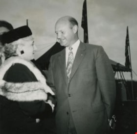
Lilian Saxby
https://search.heritageburnaby.ca/link/archivedescription37293
- Repository
- City of Burnaby Archives
- Date
- 1958
- Collection/Fonds
- Burnaby Historical Society fonds
- Description Level
- Item
- Physical Description
- 1 photograph : b&w ; 9 x 9 cm
- Scope and Content
- Photograph of Lilian Saxby greeting an unidentified man at the official opening of the Centennial Pavilion on Burnaby Mountain.
- Repository
- City of Burnaby Archives
- Date
- 1958
- Collection/Fonds
- Burnaby Historical Society fonds
- Subseries
- Norah Code subseries
- Physical Description
- 1 photograph : b&w ; 9 x 9 cm
- Description Level
- Item
- Record No.
- 345-014
- Access Restriction
- No restrictions
- Reproduction Restriction
- Reproduce for fair dealing purposes only
- Accession Number
- BHS1997-05
- Scope and Content
- Photograph of Lilian Saxby greeting an unidentified man at the official opening of the Centennial Pavilion on Burnaby Mountain.
- Subjects
- Events - Openings
- Names
- Saxby, Lilian
- Media Type
- Photograph
- Photographer
- Code, Norah
- Notes
- Title based on contents of photograph.
- Photographs in this collection were taken and compiled by Norah Code, former editor of the "Burnaby Courier" newspaper during the course of her work for the newspaper.
- Geographic Access
- Burnaby Mountain Conservation Area
- Centennial Way
- Street Address
- 100 Centennial Way
- Planning Study Area
- Burnaby Mountain Area
Images

![Louise Irwin running at Barnet, [1929] (date of original), copied 2004 thumbnail](/media/hpo/_Data/_BVM_Images/2019/2019_0032_0080_001.jpg?width=280)
Louise Irwin running at Barnet
https://search.heritageburnaby.ca/link/museumdescription15261
- Repository
- Burnaby Village Museum
- Date
- [1929] (date of original), copied 2004
- Collection/Fonds
- In the Shadow by the Sea collection
- Description Level
- Item
- Physical Description
- 1 photograph (tiff) : 300 dpi
- Scope and Content
- Photograph of young Louise Irwin running down a wooden sidewalk at the Barnet mill. The home of the Barnet Lumber Company manager, Mr. Reid and his wife is visible in the distance. An unidentified person is riding bicycle behind Louise.
- Repository
- Burnaby Village Museum
- Collection/Fonds
- In the Shadow by the Sea collection
- Description Level
- Item
- Physical Description
- 1 photograph (tiff) : 300 dpi
- Scope and Content
- Photograph of young Louise Irwin running down a wooden sidewalk at the Barnet mill. The home of the Barnet Lumber Company manager, Mr. Reid and his wife is visible in the distance. An unidentified person is riding bicycle behind Louise.
- Geographic Access
- Burrard Inlet
- Accession Code
- BV019.32.80
- Access Restriction
- No restrictions
- Reproduction Restriction
- No known restrictions
- Date
- [1929] (date of original), copied 2004
- Media Type
- Photograph
- Historic Neighbourhood
- Barnet (Historic Neighbourhood)
- Planning Study Area
- Burnaby Mountain Area
- Notes
- Title based on contents of photograph
Images
![Louise Irwin running at Barnet, [1929] (date of original), copied 2004 thumbnail](/media/hpo/_Data/_BVM_Images/2019/2019_0032_0080_001.jpg)
![Mr. H.S. Irwin in automobile, [1928] (date of original), copied 2004 thumbnail](/media/hpo/_Data/_BVM_Images/2019/2019_0032_0063_001.jpg?width=280)
Mr. H.S. Irwin in automobile
https://search.heritageburnaby.ca/link/museumdescription15244
- Repository
- Burnaby Village Museum
- Date
- [1928] (date of original), copied 2004
- Collection/Fonds
- In the Shadow by the Sea collection
- Description Level
- Item
- Physical Description
- 1 photograph (tiff) : 300 dpi
- Scope and Content
- Photograph of Henry Stanley Irwin at the driver's seat of his Dodge automobile. The automobile is parked alongside a picket fence, outside of the manager's residence where Henry and his family resided at the Barnet Lumber Mill.A row of trees runs alongside the fence with cherry trees in bloom.
- Repository
- Burnaby Village Museum
- Collection/Fonds
- In the Shadow by the Sea collection
- Description Level
- Item
- Physical Description
- 1 photograph (tiff) : 300 dpi
- Scope and Content
- Photograph of Henry Stanley Irwin at the driver's seat of his Dodge automobile. The automobile is parked alongside a picket fence, outside of the manager's residence where Henry and his family resided at the Barnet Lumber Mill.A row of trees runs alongside the fence with cherry trees in bloom.
- Subjects
- Transportation - Automobiles
- Geographic Access
- Burrard Inlet
- Accession Code
- BV019.32.63
- Access Restriction
- No restrictions
- Reproduction Restriction
- No known restrictions
- Date
- [1928] (date of original), copied 2004
- Media Type
- Photograph
- Historic Neighbourhood
- Barnet (Historic Neighbourhood)
- Planning Study Area
- Burnaby Mountain Area
- Notes
- Title based on contents of photograph
- See page 53 of book, "In the Shadow by the Sea: Recollections of Burnaby's Barnet Village" with caption "Mr. H.S. Irwin in his "Hupmobile" car, 1928."
Images
![Mr. H.S. Irwin in automobile, [1928] (date of original), copied 2004 thumbnail](/media/hpo/_Data/_BVM_Images/2019/2019_0032_0063_001.jpg)

Municipality of Burnaby - Volume XVI and Volume XVII
https://search.heritageburnaby.ca/link/museumdescription8684
- Repository
- Burnaby Village Museum
- Date
- May 1927
- Collection/Fonds
- Burnaby Village Museum Map collection
- Description Level
- File
- Physical Description
- 4 plans on 4 sheets : col. lithographic prints ; 63.5 x 53.5 cm folded to 53 x 31.5 cm
- Scope and Content
- File consists of four pages of plans removed from a bound book containing a series of fire insurance plans of the Municipality of Burnaby. Page "D" is titled: "GREATER VANCOUVER B.C. / VOLUME XVI / Surveyed _ May 1927 / MUNICIPALITY OF / BURNABY / PLAN DEPT. FIRE BRANCH _ B.C. INSURANCE UNDERWRITE…
- Repository
- Burnaby Village Museum
- Collection/Fonds
- Burnaby Village Museum Map collection
- Description Level
- File
- Physical Description
- 4 plans on 4 sheets : col. lithographic prints ; 63.5 x 53.5 cm folded to 53 x 31.5 cm
- Material Details
- Scale [1:1200] and [1:6000]
- Scope and Content
- File consists of four pages of plans removed from a bound book containing a series of fire insurance plans of the Municipality of Burnaby. Page "D" is titled: "GREATER VANCOUVER B.C. / VOLUME XVI / Surveyed _ May 1927 / MUNICIPALITY OF / BURNABY / PLAN DEPT. FIRE BRANCH _ B.C. INSURANCE UNDERWRITERS ASSN." / KEY PLAN". Plans covered in this "Key Plan" are numbered 1601 to 1626, 1632 and 1651 covering District Lots: 15; 31; 100 to 102; 114; 141 to 144; 147 and 148; 209 to 214. Plan "E" is part of "GREATER VANCOUVER B.C. / VOLUME XVII / Municipality of Burnaby / May 1927" and covers plans: 1701 to 1705; 1711 to 1715; 1723 to 1727; 1729 to 1733; 1737 to 1742 and District Lots: 68 to 74; 80 to 84; 32 to 35 and 38 to 39. Plan marked "F" is a key plan titled: "GREATER VANCOUVER B.C. / VOLUME XVII / Surveyed _ May 1927 / MUNICIPALITY OF / BURNABY and covers plans: 1706 to 1710; 1716 to 1722; 1734 and 1735; 1743 to 1752 and District Lots: 42 to 44; 59; 75 to 80; 83 to 87; 89 to 93 and 130. Plan "1729" is part of "GREATER VANCOUVER B.C. / VOLUME XVII / Municipality of Burnaby / May 1927" and covers District Lots 34 and 35.
- Responsibility
- British Columbia Underwriters' Association
- Accession Code
- HV972.111.6
- Access Restriction
- No restrictions
- Reproduction Restriction
- May be restricted by third party rights
- Date
- May 1927
- Media Type
- Cartographic Material
- Historic Neighbourhood
- Barnet (Historic Neighbourhood)
- Burquitlam (Historic Neighbourhood)
- Central Park (Historic Neighbourhood)
- Burnaby Lake (Historic Neighbourhood)
- Broadview (Historic Neighbourhood)
- Planning Study Area
- Burnaby Mountain Area
- Lyndhurst Area
- Lake City Area
- Cascade-Schou Area
- Garden Village Area
- Douglas-Gilpin Area
- Oakalla Area
- Scan Resolution
- 400
- Scan Date
- 2021-11-18
- Notes
- Title based on content of plans
- See also BV987.1.70d for revised versions of plans
- Scale is measured 1 inch = 500 feet
Zoomable Images


![Nichols Chemical Co. Ltd. - D.D. Coolers Scrubbers and Settling Tanks with Pumps, [1928] thumbnail](/media/hpo/_Data/_BVM_Technical_Drawings/1998_0023_0016_002.jpg?width=280)
Nichols Chemical Co. Ltd. - D.D. Coolers Scrubbers and Settling Tanks with Pumps
https://search.heritageburnaby.ca/link/museumdescription11394
- Repository
- Burnaby Village Museum
- Date
- [1928]
- Collection/Fonds
- Nichols Chemical Company fonds
- Description Level
- Item
- Physical Description
- 1 technical drawing : blueprint ; 75.5 x 105 cm
- Scope and Content
- Item consists of technical drawing "D.D. Coolers Scrubbers and Settling Tanks with Pumps", "Nichols Chemical Co. LTD."; "Drawing No. 6314".
- Repository
- Burnaby Village Museum
- Collection/Fonds
- Nichols Chemical Company fonds
- Description Level
- Item
- Physical Description
- 1 technical drawing : blueprint ; 75.5 x 105 cm
- Material Details
- Scale 1:.25
- Scope and Content
- Item consists of technical drawing "D.D. Coolers Scrubbers and Settling Tanks with Pumps", "Nichols Chemical Co. LTD."; "Drawing No. 6314".
- Subjects
- Buildings - Industrial - Factories
- Responsibility
- General Chemical Company
- Geographic Access
- Barnet Road
- Street Address
- 8655 Barnet Road
- Accession Code
- BV998.23.16
- Access Restriction
- No restrictions
- Reproduction Restriction
- No known restrictions
- Date
- [1928]
- Media Type
- Technical Drawing
- Historic Neighbourhood
- Barnet (Historic Neighbourhood)
- Planning Study Area
- Burnaby Mountain Area
- Scan Resolution
- 300
- Scan Date
- 2022-05-10
- Notes
- Title based on contents of item
- "Scale 1/4" = 1'
- Stamp in lower left corner reads: "Private Design", "This Property Exclusively of General Chemical Company"
- Stamp on lower right reads: "Jul 12, 1946"
Images
![Nichols Chemical Co. Ltd. - D.D. Coolers Scrubbers and Settling Tanks with Pumps, [1928] thumbnail](/media/hpo/_Data/_BVM_Technical_Drawings/1998_0023_0016_002.jpg)
![Nichols Chemical Co. Ltd. - Drawing No. 6312, [1928] thumbnail](/media/hpo/_Data/_BVM_Technical_Drawings/1998_0023_0010_002.jpg?width=280)
Nichols Chemical Co. Ltd. - Drawing No. 6312
https://search.heritageburnaby.ca/link/museumdescription11388
- Repository
- Burnaby Village Museum
- Date
- [1928]
- Collection/Fonds
- Nichols Chemical Company fonds
- Description Level
- Item
- Physical Description
- 1 technical drawing : blueprint ; 73.5 x 104.5 cm
- Scope and Content
- Item consists of technical "Drawing No. 6312" "Nichols Chemical Co. Ltd.".
- Repository
- Burnaby Village Museum
- Collection/Fonds
- Nichols Chemical Company fonds
- Description Level
- Item
- Physical Description
- 1 technical drawing : blueprint ; 73.5 x 104.5 cm
- Material Details
- Scale 1:.25
- Scope and Content
- Item consists of technical "Drawing No. 6312" "Nichols Chemical Co. Ltd.".
- Subjects
- Buildings - Industrial - Factories
- Responsibility
- General Chemical Company
- Geographic Access
- Barnet Road
- Street Address
- 8655 Barnet Road
- Accession Code
- BV998.23.10
- Access Restriction
- No restrictions
- Reproduction Restriction
- No known restrictions
- Date
- [1928]
- Media Type
- Technical Drawing
- Historic Neighbourhood
- Barnet (Historic Neighbourhood)
- Planning Study Area
- Burnaby Mountain Area
- Scan Resolution
- 300
- Scan Date
- 2022-05-10
- Notes
- Title based on contents of item
- Hand-stamped horizontally is "MAR 12 1946"
- Stamp on back reads: "Private Design", "The Property Exclusively of General Chemical Company"
- "Scale 1/4" = 1'
Images
![Nichols Chemical Co. Ltd. - Drawing No. 6312, [1928] thumbnail](/media/hpo/_Data/_BVM_Technical_Drawings/1998_0023_0010_002.jpg)
![Nichols Chemical Co. Ltd. - Drawing No. 50785, [1959] thumbnail](/media/hpo/_Data/_BVM_Technical_Drawings/1998_0023_0014_002.jpg?width=280)
Nichols Chemical Co. Ltd. - Drawing No. 50785
https://search.heritageburnaby.ca/link/museumdescription11392
- Repository
- Burnaby Village Museum
- Date
- [1959]
- Collection/Fonds
- Nichols Chemical Company fonds
- Description Level
- Item
- Physical Description
- 1 technical drawing : blueline print ; 87.5 x 111 cm
- Scope and Content
- Item consists of technical drawing identified as No. 50785 with handwritten annotation reading "W.O.M. - 8560". Property Exclusively of General Chemical Company.
- Repository
- Burnaby Village Museum
- Collection/Fonds
- Nichols Chemical Company fonds
- Description Level
- Item
- Physical Description
- 1 technical drawing : blueline print ; 87.5 x 111 cm
- Material Details
- Scale 1:.25
- Scope and Content
- Item consists of technical drawing identified as No. 50785 with handwritten annotation reading "W.O.M. - 8560". Property Exclusively of General Chemical Company.
- Subjects
- Buildings - Industrial - Factories
- Responsibility
- General Chemical Company
- Geographic Access
- Barnet Road
- Street Address
- 8655 Barnet Road
- Accession Code
- BV998.23.14
- Access Restriction
- No restrictions
- Reproduction Restriction
- No known restrictions
- Date
- [1959]
- Media Type
- Technical Drawing
- Historic Neighbourhood
- Barnet (Historic Neighbourhood)
- Planning Study Area
- Burnaby Mountain Area
- Scan Resolution
- 300
- Scan Date
- 2022-05-10
- Notes
- Title based on contents of item
- Stamp on verso reads: "R.L. Johnston"
- "Scale 1/4" = 1'
- Date stampled "Oct. 19 1959"
- Annotation next to date stamp reads: "Dwg Rec'd 10-24-59"
- Stamp at bottom reads: "Property of / General Chemical Division / Allied Chemical & Dye Corporation"
Images
![Nichols Chemical Co. Ltd. - Drawing No. 50785, [1959] thumbnail](/media/hpo/_Data/_BVM_Technical_Drawings/1998_0023_0014_002.jpg)
![Norm Northam, Jim LaFavor and Frank Laleune at Barnet, [1950] (date of original), copied 2004 thumbnail](/media/hpo/_Data/_BVM_Images/2019/2019_0032_0111_001.jpg?width=280)
Norm Northam, Jim LaFavor and Frank Laleune at Barnet
https://search.heritageburnaby.ca/link/museumdescription15305
- Repository
- Burnaby Village Museum
- Date
- [1950] (date of original), copied 2004
- Collection/Fonds
- In the Shadow by the Sea collection
- Description Level
- Item
- Physical Description
- 1 photograph (tiff) : 300 dpi
- Scope and Content
- Photograph of Norm Northam (back), Jim LaFavor (middle) and Frank Laleune (front) seated together on the grass in a yard in Barnet. Fences, a building and the lower slope of Burnaby mountain are visible behind them.
- Repository
- Burnaby Village Museum
- Collection/Fonds
- In the Shadow by the Sea collection
- Description Level
- Item
- Physical Description
- 1 photograph (tiff) : 300 dpi
- Scope and Content
- Photograph of Norm Northam (back), Jim LaFavor (middle) and Frank Laleune (front) seated together on the grass in a yard in Barnet. Fences, a building and the lower slope of Burnaby mountain are visible behind them.
- Geographic Access
- Burrard Inlet
- Accession Code
- BV019.32.111
- Access Restriction
- No restrictions
- Reproduction Restriction
- No known restrictions
- Date
- [1950] (date of original), copied 2004
- Media Type
- Photograph
- Historic Neighbourhood
- Barnet (Historic Neighbourhood)
- Planning Study Area
- Burnaby Mountain Area
- Notes
- Title based on contents of photograph
Images
![Norm Northam, Jim LaFavor and Frank Laleune at Barnet, [1950] (date of original), copied 2004 thumbnail](/media/hpo/_Data/_BVM_Images/2019/2019_0032_0111_001.jpg)