Narrow Results By
Decade
- 2020s 223
- 2010s 148
- 2000s 1821
- 1990s 2867
- 1980s 1363
- 1970s 3510
- 1960s 1351
- 1950s 1669
- 1940s
- 1930s 2066
- 1920s 2344
- 1910s 1867
- 1900s 846
- 1890s 248
- 1880s 165
- 1870s 72
- 1860s 123
- 1850s 14
- 1840s 5
- 1830s 3
- 1820s 2
- 1810s 3
- 1800s 3
- 1790s 2
- 1780s 2
- 1770s 2
- 1760s 2
- 1750s 2
- 1740s 2
- 1730s 2
- 1720s 2
- 1710s 2
- 1700s 2
- 1690s 2
- 1680s 2
- 1670s 1
- 1660s 1
- 1650s 1
- 1640s 1
- 1630s 1
- 1620s 1
- 1610s 1
- 1600s 1
- 1590s 1
- 1580s 1
- 1570s 1
- 1560s 1
- 1550s 1
- 1540s 1
- 1530s 1
- 1520s 2
- 1510s 1
- 1500s 1
- 1490s 1
- 1480s 1
Subject
- Accidents - Automobile Accidents 3
- Accidents - Train Accidents 6
- Advertising Medium - Signs and Signboards 10
- Aerial Photographs 7
- Agricultural Tools and Equipment 5
- Agricultural Tools and Equipment - Cultivators 2
- Agricultural Tools and Equipment - Gardening Equipment 1
- Agricultural Tools and Equipment - Plows 1
- Agricultural Tools and Equipment - Tractors 1
- Agriculture - Crops 1
- Agriculture - Farms 25
- Agriculture - Fruit and Berries 2
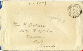
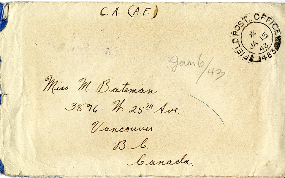
Letter from Brigadeer Colin Fox to May Bateman
https://search.heritageburnaby.ca/link/museumdescription15125
- Repository
- Burnaby Village Museum
- Date
- 6 Jan. 1943
- Collection/Fonds
- E.W. Bateman family fonds
- Description Level
- Item
- Physical Description
- 1 p. (double sided and folded) + 1 envelope
- Scope and Content
- Item consists of a letter written by Lt. Sergeant Colin Rhodes Fox of the Royal Canadian Artillery Service to his aunt Marianne "May" Bateman while serving overseas during World War II. Colin Fox served in the 13th Canadian Field Regiment, 44th Canadian Field Battery. In his letter, Colin thanks hi…
- Repository
- Burnaby Village Museum
- Collection/Fonds
- E.W. Bateman family fonds
- Description Level
- Item
- Physical Description
- 1 p. (double sided and folded) + 1 envelope
- Scope and Content
- Item consists of a letter written by Lt. Sergeant Colin Rhodes Fox of the Royal Canadian Artillery Service to his aunt Marianne "May" Bateman while serving overseas during World War II. Colin Fox served in the 13th Canadian Field Regiment, 44th Canadian Field Battery. In his letter, Colin thanks his aunt for parcels that he's received and reflects on his Christmas and New Years celebration.
- Accession Code
- BV020.27.13
- Access Restriction
- Restricted access
- Reproduction Restriction
- May be restricted by third party rights
- Date
- 6 Jan. 1943
- Media Type
- Textual Record
- Scan Resolution
- 600
- Scan Date
- 10-Feb-2021
- Scale
- 100
- Notes
- Title based on contents of item
- Address on front of envelope reads: "Miss M. Bateman / 3896 W. 25th Ave. / Vancouver B.C. / Canada"
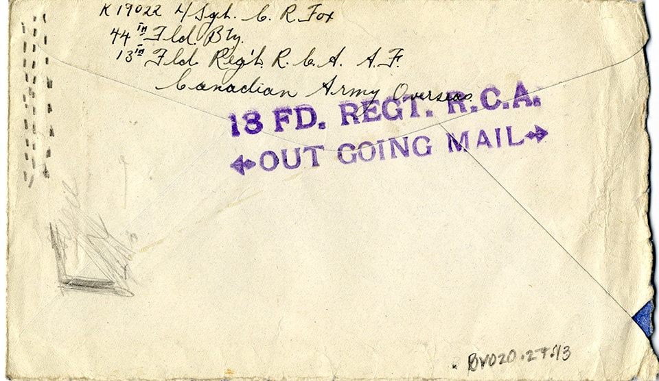
- Return address on verso of envelope reads: "K 19022 L/Sgt. C.R. Fox / 44th Fld. Bty. / 13th Fld. Reg't. R.C.A. A.F. / Canadian Army Overseas"
- Stamp on verso of envelope reads: "13 FD. REGT. R.C.A. / OUT GOING MAIL"
- Circular post mark stamp on front of envelope reads: "FIELDPOST_OFFICE_483_JAN. 15 /43"
Images

Vancouver Heights Neighbourhood
https://search.heritageburnaby.ca/link/landmark666
- Repository
- Burnaby Heritage Planning
- Associated Dates
- 1925-1954
- Heritage Value
- Vancouver Heights remained an important residential and commercial centre in Burnaby throughout the 1925-1954 period. The area had its own Board of Trade and the North Burnaby Library was created to serve the residents. In 1949, the Hastings streetcars stopped running, but the area retained its reputation as one of the best shopping districts in the city.
- Historic Neighbourhood
- Vancouver Heights (Historic Neighbourhood)
- Planning Study Area
- Burnaby Heights Area
Images


Capitol Hill Neighbourhood
https://search.heritageburnaby.ca/link/landmark667
- Repository
- Burnaby Heritage Planning
- Associated Dates
- 1925-1954
- Heritage Value
- Although the Hastings street-car extension to Ellesmere opened in 1913 and there had been much speculation in the area during the real estate boom of 1909-1913, development in Capitol Hill did not really take off until after World War One when workers in Vancouver started to look to Burnaby for affordable but centrally-located neighbourhoods in which to build their homes. The 1913 one-room school had to be replaced in 1923 and in 1948, members of the community came together to build a new Community Hall.
- Historic Neighbourhood
- Capitol Hill (Historic Neighbourhood)
- Planning Study Area
- Capitol Hill Area
Images


Lochdale Neighbourhood
https://search.heritageburnaby.ca/link/landmark668
- Repository
- Burnaby Heritage Planning
- Associated Dates
- 1925-1954
- Heritage Value
- In the 1931 "Burnaby Year Book" the Lochdale neighbourhood is described as follows: "Lochdale…is situated at the intersection of the Hastings-Barnet road at the point where Sperling Avenue crosses…Situated at the intersection…there are an up to date service station and a general store, at which the Lochdale Post Office is situated. Immediately north of this is the seventy acres on which the Shell Oil Co. are to build an up-to-date refinery...On going south on Sperling Avenue can be found some lovely homes of the residents, all of which possess the most beautiful flower gardens, some of which are hobbies, and some being in the nature of a business. Others are engaged in chicken farming...while others find employment at the Barnet Mill about two miles east on the Hastings-Barnet Road."
- Historic Neighbourhood
- Lochdale (Historic Neighbourhood)
- Planning Study Area
- Lochdale Area
Images


Brentwood Neighbourhood
https://search.heritageburnaby.ca/link/landmark669
- Repository
- Burnaby Heritage Planning
- Associated Dates
- 1925-1954
- Heritage Value
- In July, 1953, Burnaby's Municipal Council gave approval for the construction of a $12,000,000 residential and shopping development to be called Brentwood Park, located on the northeast corner of Lougheed and Willingdon. Plans called for about 400 homes and a 30-acre shopping centre to be built in this new subdivision - the first large residential subdivision in Burnaby to be developed with sewers and paved streets as well as other services.
- Planning Study Area
- Brentwood Area
Images


Willingdon Heights Neighbourhood
https://search.heritageburnaby.ca/link/landmark670
- Repository
- Burnaby Heritage Planning
- Associated Dates
- 1925-1954
- Heritage Value
- Willingdon Heights was another new subdivision developed in Burnaby during the post-World War Two building boom. A brochure about the development published in 1948 proclaimed "the Willingdon Heights 500 home development project in Burnaby fulfills its promise to provide a self-contained community for former members of the armed services and their families...the largest single veteran housing project in Canada as far as homes for individual ownership is concerned, Willingdon Heights development was planned by the Central Mortgage and Housing Corporation...At this date the earlier built rows of homes have passable roads and the owners are improving lawns and gardens in spare time...eventually additional stores and professional services will be installed and recreational projects will add to the amenities of a community of congenial residents..."
- Planning Study Area
- Willingdon Heights Area
Images


Parkcrest Neighbourhood
https://search.heritageburnaby.ca/link/landmark671
- Repository
- Burnaby Heritage Planning
- Associated Dates
- 1925-1954
- Heritage Value
- On May 10, 1951, the Burnaby News-Courier reported on the new Parkcrest subdivision, saying: "Central Burnaby is the scenic locale of a successful attempt to produce modern houses economically and yet avoid the mass production effect common to other housing developments. That is one of the many highlights peculiar to the new Parkcrest development of 275 homes...By giving home purchasers a wide choice of finishes, extras and colours, hundreds of variations are possible on the six basic floor plans...Travelling time by car to Hastings and Granville from Parkcrest has been clocked at 15 minutes...Both primary and junior high schools are within walking distance. A modern shopping centre is planned for the future...Several streets are laid out in a straight but irregular manner, thus eliminating the prosaic side by side appearance block by block, as in other housing developments."
- Planning Study Area
- Parkcrest-Aubrey Area
Images


Crabtown
https://search.heritageburnaby.ca/link/landmark674
- Repository
- Burnaby Heritage Planning
- Associated Dates
- 1912-1957
- Heritage Value
- North Burnaby's waterfront was the location of a unique squatter's community known as Crabtown. Although its origins are obscure, it is believed that the first shacks were built before 1912. When the depression of 1913-1917 began, the shacks became permanent homes for impoverished workers. During the Great Depression of the 1930s, the community grew larger. Crabtown was not a slum, but a neighbourhood - the community even rallied together to build a water supply system and trails up the steep bluff with steps and banisters so children could go to school safely. In 1957, the National Harbours Board decided that Crabtown was encroaching on Federal property and evicted all 130 residents. Within a few months, residents were relocated and 114 homes were levelled.
- Historic Neighbourhood
- Vancouver Heights (Historic Neighbourhood)
- Planning Study Area
- Burnaby Heights Area
Images


Shell Oil Company
https://search.heritageburnaby.ca/link/landmark675
- Repository
- Burnaby Heritage Planning
- Geographic Access
- Kensington Avenue
- Associated Dates
- ca. 1930-1993
- Heritage Value
- After considering several sites in the Greater Vancouver area, the Shell Oil Company chose 70 acres in North Burnaby with frontage of one third of a mile on Burrard Inlet. Shell proposed to build a four-million dollar plant that would employ up to 2000 - providing some relief in the middle of Burnaby's economic crisis of the Depression years. The site became known as the Shellburn Refinery and was in operation until 1993.
- Historic Neighbourhood
- Lochdale (Historic Neighbourhood)
- Planning Study Area
- Westridge Area
Images


Westridge Neighbourhood
https://search.heritageburnaby.ca/link/landmark680
- Repository
- Burnaby Heritage Planning
- Associated Dates
- 1925-1954
- Heritage Value
- The Westridge Neighbourhood of Burnaby was created as a new subdivision during the post-World War Two housing boom in Burnaby. Developed by the C.B. Riley Company, it was laid out in a plan contoured to the shapes of the land and was situated to allow residents easy access to main transportation routes.
- Historic Neighbourhood
- Lochdale (Historic Neighbourhood)
- Planning Study Area
- Westridge Area
Images


Barnet Neighbourhood
https://search.heritageburnaby.ca/link/landmark681
- Repository
- Burnaby Heritage Planning
- Associated Dates
- 1925-1954
- Heritage Value
- In 1925, the mill at Barnet was under new ownership and was known as the Barnet Lumber Company. It was one of the most successful local employers in Burnaby until the 1930s, when the economic crisis of the Great Depression resulted in a strike at the mill. The City of Burnaby eventually assumed control of the site - including all of the homes - when the company failed to pay its taxes. The City then dismantled the mill and resold the property in two parts - the eastern section would become the Kapoor sawmill and the western portion, the McColl-Frontenac Oil Company.
- Historic Neighbourhood
- Barnet (Historic Neighbourhood)
- Planning Study Area
- Burnaby Mountain Area
Images


Broadview Neighbourhood
https://search.heritageburnaby.ca/link/landmark687
- Repository
- Burnaby Heritage Planning
- Associated Dates
- 1925-1954
- Heritage Value
- Development in the Broadview area slowed during World War Two, but after the war, the area became home to a number of industrial sites. The first major plant to be built here was the Dominion Bridge Company which opened in 1930.
- Historic Neighbourhood
- Broadview (Historic Neighbourhood)
- Planning Study Area
- Cascade-Schou Area
Images


Central Park Neighbourhood
https://search.heritageburnaby.ca/link/landmark688
- Repository
- Burnaby Heritage Planning
- Associated Dates
- 1925-1954
- Heritage Value
- Although still largely a rural area during the 1920s, subdivisions began appearing in the Central Park neighbourhood at this time. Development was slowed by the Great Depression of the 1930s but the influx of commercial buildings and new housing initiatives in the post-war boom led to a period of rapid growth especially in the Garden Village subdivision which was undertaken in 1953 with the plan to build 500 modern homes in the 140-acre site. Despite the closure of the interurban line in 1953, the neighbourhood remained an active commercial and residential centre.
- Historic Neighbourhood
- Central Park (Historic Neighbourhood)
- Planning Study Area
- Maywood Area
Images


Burnaby Lake Neighbourhood
https://search.heritageburnaby.ca/link/landmark700
- Repository
- Burnaby Heritage Planning
- Associated Dates
- 1925-1954
- Heritage Value
- After World War I and the Great Depression of the 1930s, more homes were constructed and subdivisions created in the Burnaby Lake district. The area around Deer Lake gained a reputation for being an "artistic development of commodious homes with park-like grounds."
- Historic Neighbourhood
- Burnaby Lake (Historic Neighbourhood)
- Planning Study Area
- Burnaby Lake Area
Images


Lozells Neighbourhood
https://search.heritageburnaby.ca/link/landmark701
- Repository
- Burnaby Heritage Planning
- Associated Dates
- 1925-1954
- Heritage Value
- Like a lot of residential neighbourhoods in Burnaby during the post-War boom, the Lozells area during the 1925-1954 period was one of new construction and subdivisions. Although more homes were being built, the neighbourhood still retained a somewhat rural characteristic well into the 1950s.
- Historic Neighbourhood
- Lozells (Historic Neighbourhood)
- Planning Study Area
- Government Road Area
Images


Lake City Neighbourhood
https://search.heritageburnaby.ca/link/landmark702
- Repository
- Burnaby Heritage Planning
- Associated Dates
- 1925-1954
- Heritage Value
- When the Lake City Industrial Park first opened in the 1950's, it was a fairly isolated industrial enclave with convenient access to rail and road transportation routes. The sense of entrepreneurial flare and success that was anticipated for the area is evident in the naming of local streets which include "Production", "Enterprise" and "Venture". The anticipated potential of the area was also demonstrated by the inclusion of many significant development amenities of the time, such as paved streets, site landscaping, rail service, natural gas service, and architectural controls.
- Planning Study Area
- Lake City Area
Images


Burquitlam Neighbourhood
https://search.heritageburnaby.ca/link/landmark703
- Repository
- Burnaby Heritage Planning
- Associated Dates
- 1925-1954
- Heritage Value
- By the 1950s, the Burquitlam Neighbourhood was becoming a residential and commercial centre for the northeast section of Burnaby. The Sullivan Heights area was developed as a single-family residential area with the Lyndhurst School opening in 1954. The completion of the Lougheed Highway in 1953 encouraged more commercial and retail development and fostered the growth of the neighbourhood throughout this period.
- Historic Neighbourhood
- Burquitlam (Historic Neighbourhood)
- Planning Study Area
- Lyndhurst Area
Images


Edmonds Neighbourhood
https://search.heritageburnaby.ca/link/landmark704
- Repository
- Burnaby Heritage Planning
- Associated Dates
- 1925-1954
- Heritage Value
- The historic growth of Edmonds as a neighbourhood was based on its strategic location on the early interurban line between Vancouver and New Westminster. Even by 1980 when a survey of the residential neighbourhoods was conducted, a full 25% of homes in the area predated 1930. The 1950s was a period of strong housing development, with both single-family and multi-family units being constructed. Although Burnaby's City Hall was moved from Kingsway and Edmonds in the early 1950s, Edmonds remained an important centre in the community.
- Historic Neighbourhood
- Edmonds (Historic Neighbourhood)
- Planning Study Area
- Stride Avenue Area
Images


Alta Vista Neighbourhood
https://search.heritageburnaby.ca/link/landmark707
- Repository
- Burnaby Heritage Planning
- Associated Dates
- 1925-1954
- Heritage Value
- As with many areas of Burnaby during this period, the years after World War Two marked a rapid growth in residential development in the Alta-Vista Neighbourhood. Subdivisions like Sussex and Suncrest were built and new schools and amenities were constructed to meet the demands of increased population.
- Historic Neighbourhood
- Alta Vista (Historic Neighbourhood)
- Planning Study Area
- Sussex-Nelson Area
Images


Fraser Arm Neighbourhood
https://search.heritageburnaby.ca/link/landmark708
- Repository
- Burnaby Heritage Planning
- Associated Dates
- 1925-1954
- Heritage Value
- By the late 1920s, the Fraser Arm Neighbourhood in Burnaby was developing into an industrial and manufacturing district. In 1931, the Canadian National Railway built a bridge over the Fraser River from Burnaby to Lulu Island and advertised that over 30 industries were currently operating along the North Fraser. Along with industries, this district remained an important agricultural area for the Lower Mainland. Chinese market gardens continued to develop and thrive and in 1926, the Vancouver Sun estimated that that Chinese farms in the Lower Fraser Valley then supplied 90 per cent of all green vegetables consumed in the Vancouver market area.
- Historic Neighbourhood
- Fraser Arm (Historic Neighbourhood)
- Planning Study Area
- Big Bend Area
Images


East Burnaby Neighbourhood
https://search.heritageburnaby.ca/link/landmark712
- Repository
- Burnaby Heritage Planning
- Associated Dates
- 1925-1954
- Heritage Value
- After a lull in construction during the World War I period, East Burnaby Neighbourhood's growth resumed during the 1920s when many homes and businesses were constructed. The post-World War Two period also saw rapid construction and the creation of new housing developments in response to a population boom. The neighbourhood remained a primarily single-family residential area.
- Historic Neighbourhood
- Edmonds (Historic Neighbourhood)
- Planning Study Area
- Stride Avenue Area
Images


Burnaby North High School
https://search.heritageburnaby.ca/link/landmark745
- Repository
- Burnaby Heritage Planning
- Associated Dates
- 1923-1982
- Street View URL
- Google Maps Street View
- Repository
- Burnaby Heritage Planning
- Geographic Access
- Willingdon Avenue
- Associated Dates
- 1923-1982
- Heritage Value
- Burnaby North and Burnaby South were the first high schools built in the City. Before the high school opened, Burnaby students had to travel to Vancouver if they wished to pursue education beyond an elementary level. In 1921, arrangements were made to use the basement of the Presbyterian Church for instruction of local students. By 1922 the Burnaby North High School opened at its first permanent location (4375 Pandora Street - which is now Rosser Elementary). In 1945, the Willingdon Avenue site was built and was used until a new building was constructed in 1961 on Hammarskjold Drive. From 1962, the school was used as Burnaby Heights Junior High school, but it closed in 1982 and the junior high students went to the new Burnaby North on Hammarskjold.
- Historic Neighbourhood
- Capitol Hill (Historic Neighbourhood)
- Planning Study Area
- Capitol Hill Area
- Street Address
- 250 Willingdon Avenue
- Street View URL
- Google Maps Street View
Images


Burnaby South High School
https://search.heritageburnaby.ca/link/landmark770
- Repository
- Burnaby Heritage Planning
- Associated Dates
- 1922-1988
- Street View URL
- Google Maps Street View
- Repository
- Burnaby Heritage Planning
- Geographic Access
- Southoaks Crescent
- Associated Dates
- 1922-1988
- Heritage Value
- Burnaby South and Burnaby North were Burnaby's first high schools. The first rooms of the school were built in 1922 on the same grounds as the Kingsway East Elementary School. In 1940, a two-storey building was erected and additions were made in 1963, 1967 and 1972. Kingsway East closed in 1925 and its buildings were used by the high school for Industrial Arts and Home Economics. In the early 1990s, a new "urban education centre" (Burnaby South/B.C. School for the Deaf) was opened, replacing the old Burnaby South High School.
- Historic Neighbourhood
- Edmonds (Historic Neighbourhood)
- Planning Study Area
- Kingsway-Beresford Area
- Street Address
- 6650 Southoaks Crescent
- Street View URL
- Google Maps Street View
Images

![Cascade Drive-In Theatre, [1949] (date of original), copied 1991 thumbnail](/media/hpo/_Data/_Archives_Images/_Unrestricted/370/370-468.jpg?width=280)
Cascade Drive-In Theatre
https://search.heritageburnaby.ca/link/archivedescription37880
- Repository
- City of Burnaby Archives
- Date
- [1949] (date of original), copied 1991
- Collection/Fonds
- Burnaby Historical Society fonds
- Description Level
- Item
- Physical Description
- 1 photograph : b&w ; 3.0 x 4.4 cm print on contact sheet 20.1 x 26.7 cm
- Scope and Content
- Photograph of the Cascade Drive-In Theatre at 4050 Grandview Highway.
- Repository
- City of Burnaby Archives
- Date
- [1949] (date of original), copied 1991
- Collection/Fonds
- Burnaby Historical Society fonds
- Subseries
- Burnaby Image Bank subseries
- Physical Description
- 1 photograph : b&w ; 3.0 x 4.4 cm print on contact sheet 20.1 x 26.7 cm
- Description Level
- Item
- Record No.
- 370-468
- Access Restriction
- No restrictions
- Reproduction Restriction
- Reproduce for fair dealing purposes only
- Accession Number
- BHS1999-03
- Scope and Content
- Photograph of the Cascade Drive-In Theatre at 4050 Grandview Highway.
- Names
- Cascade Drive-In Theatre
- Media Type
- Photograph
- Photographer
- Van Dyke Studios
- Notes
- Title based on contents of photograph
- 1 b&w copy negative accompanying
- Negative has a pink cast
- Geographic Access
- Grandview Highway
- Street Address
- 4050 Grandview Highway
- Historic Neighbourhood
- Broadview (Historic Neighbourhood)
- Planning Study Area
- West Central Valley Area
Images
![Cascade Drive-In Theatre, [1949] (date of original), copied 1991 thumbnail](/media/hpo/_Data/_Archives_Images/_Unrestricted/370/370-468.jpg)
![1007 Gilley Avenue, [1949 or 1950] (date of original), copied 1991 thumbnail](/media/hpo/_Data/_Archives_Images/_Unrestricted/370/370-667.jpg?width=280)
1007 Gilley Avenue
https://search.heritageburnaby.ca/link/archivedescription38080
- Repository
- City of Burnaby Archives
- Date
- [1949 or 1950] (date of original), copied 1991
- Collection/Fonds
- Burnaby Historical Society fonds
- Description Level
- Item
- Physical Description
- 1 photograph : b&w ; 3.0 x 3.0 cm print on contact sheet 20.2 x 26.2 cm
- Scope and Content
- Photograph of the back of 1007 Gilley Avenue (later renumbered 8416 Gilley Avenue).
- Repository
- City of Burnaby Archives
- Date
- [1949 or 1950] (date of original), copied 1991
- Collection/Fonds
- Burnaby Historical Society fonds
- Subseries
- Burnaby Image Bank subseries
- Physical Description
- 1 photograph : b&w ; 3.0 x 3.0 cm print on contact sheet 20.2 x 26.2 cm
- Description Level
- Item
- Record No.
- 370-667
- Access Restriction
- No restrictions
- Reproduction Restriction
- No restrictions
- Accession Number
- BHS1999-03
- Scope and Content
- Photograph of the back of 1007 Gilley Avenue (later renumbered 8416 Gilley Avenue).
- Subjects
- Buildings - Residential - Houses
- Media Type
- Photograph
- Notes
- Title based on contents of photograph
- 1 b&w copy negative accompanying
- Negative has a pink cast
- Geographic Access
- Gilley Avenue
- Street Address
- 8416 Gilley Avenue
- Planning Study Area
- Stride Hill Area
Images
![1007 Gilley Avenue, [1949 or 1950] (date of original), copied 1991 thumbnail](/media/hpo/_Data/_Archives_Images/_Unrestricted/370/370-667.jpg)
![Lyle and Evelyn Le Grove, [1949] (date of original), copied 1991 thumbnail](/media/hpo/_Data/_Archives_Images/_Unrestricted/370/370-668.jpg?width=280)
Lyle and Evelyn Le Grove
https://search.heritageburnaby.ca/link/archivedescription38081
- Repository
- City of Burnaby Archives
- Date
- [1949] (date of original), copied 1991
- Collection/Fonds
- Burnaby Historical Society fonds
- Description Level
- Item
- Physical Description
- 1 photograph : b&w ; 3.0 x 3.0 cm print on contact sheet 20.2 x 26.2 cm
- Scope and Content
- Photograph of husband and wife Lyle and Evelyn Le Grove standing in front of 1007 Gilley Avenue (later renumbered 8416 Gilley Avenue).
- Repository
- City of Burnaby Archives
- Date
- [1949] (date of original), copied 1991
- Collection/Fonds
- Burnaby Historical Society fonds
- Subseries
- Burnaby Image Bank subseries
- Physical Description
- 1 photograph : b&w ; 3.0 x 3.0 cm print on contact sheet 20.2 x 26.2 cm
- Description Level
- Item
- Record No.
- 370-668
- Access Restriction
- No restrictions
- Reproduction Restriction
- No restrictions
- Accession Number
- BHS1999-03
- Scope and Content
- Photograph of husband and wife Lyle and Evelyn Le Grove standing in front of 1007 Gilley Avenue (later renumbered 8416 Gilley Avenue).
- Media Type
- Photograph
- Notes
- Title based on contents of photograph
- 1 b&w copy negative accompanying
- Negative has a pink cast
- Geographic Access
- Gilley Avenue
- Street Address
- 8416 Gilley Avenue
- Planning Study Area
- Stride Hill Area
Images
![Lyle and Evelyn Le Grove, [1949] (date of original), copied 1991 thumbnail](/media/hpo/_Data/_Archives_Images/_Unrestricted/370/370-668.jpg)
![Edmonds School class, 1949 [copied 200-?] thumbnail](/media/hpo/_Data/_Archives_Images/_Unrestricted/371/434-001.jpg?width=280)
Edmonds School class
https://search.heritageburnaby.ca/link/archivedescription38415
- Repository
- City of Burnaby Archives
- Date
- 1949 [copied 200-?]
- Collection/Fonds
- Burnaby Historical Society fonds
- Description Level
- Item
- Physical Description
- 1 photograph : b&w ; 20 x 25 cm + 1 p.
- Scope and Content
- Photograph of the grade nine class at Edmonds School standing together on the school's steps.
- Repository
- City of Burnaby Archives
- Date
- 1949 [copied 200-?]
- Collection/Fonds
- Burnaby Historical Society fonds
- Subseries
- Burnaby Retired Teachers subseries
- Physical Description
- 1 photograph : b&w ; 20 x 25 cm + 1 p.
- Description Level
- Item
- Record No.
- 434-001
- Access Restriction
- No restrictions
- Reproduction Restriction
- Reproduce for fair dealing purposes only
- Accession Number
- BHS2002-11
- Scope and Content
- Photograph of the grade nine class at Edmonds School standing together on the school's steps.
- Names
- Edmonds Community School
- Media Type
- Photograph
- Notes
- Title based on contents of photograph
- 1 page accompanying is an identification key
- Geographic Access
- 18th Avenue
- Street Address
- 7651 18th Avenue
- Historic Neighbourhood
- Edmonds (Historic Neighbourhood)
- Planning Study Area
- Edmonds Area
Images
![Edmonds School class, 1949 [copied 200-?] thumbnail](/media/hpo/_Data/_Archives_Images/_Unrestricted/371/434-001.jpg)
![George A. Grant, [1949] thumbnail](/media/hpo/_Data/_Archives_Images/_Unrestricted/480/480-170.jpg?width=280)
George A. Grant
https://search.heritageburnaby.ca/link/archivedescription45274
- Repository
- City of Burnaby Archives
- Date
- [1949]
- Collection/Fonds
- Columbian Newspaper collection
- Description Level
- Item
- Physical Description
- 1 photograph : b&w ; 16.5 x 11.5 cm
- Scope and Content
- Photograph of Burnaby Police Magistrate and Juvenille Court Judge George A. Grant.
- Repository
- City of Burnaby Archives
- Date
- [1949]
- Collection/Fonds
- Columbian Newspaper collection
- Physical Description
- 1 photograph : b&w ; 16.5 x 11.5 cm
- Description Level
- Item
- Record No.
- 480-170
- Access Restriction
- No restrictions
- Reproduction Restriction
- Reproduce for fair dealing purposes only
- Accession Number
- 2003-02
- Scope and Content
- Photograph of Burnaby Police Magistrate and Juvenille Court Judge George A. Grant.
- Subjects
- Officials - Judges
- Names
- Grant, George Alford
- Media Type
- Photograph
- Notes
- Title based on contents of photograph
Images
![George A. Grant, [1949] thumbnail](/media/hpo/_Data/_Archives_Images/_Unrestricted/480/480-170.jpg)
![George A. Morrison, [1949] thumbnail](/media/hpo/_Data/_Archives_Images/_Unrestricted/480/480-716.jpg?width=280)
George A. Morrison
https://search.heritageburnaby.ca/link/archivedescription45822
- Repository
- City of Burnaby Archives
- Date
- [1949]
- Collection/Fonds
- Columbian Newspaper collection
- Description Level
- Item
- Physical Description
- 1 photograph : b&w ; 17.5 x 11 cm
- Scope and Content
- Photograph of George A. Morrison, Reeve of Burnaby from 1945 to 1949 and Council member in 1944.
- Repository
- City of Burnaby Archives
- Date
- [1949]
- Collection/Fonds
- Columbian Newspaper collection
- Physical Description
- 1 photograph : b&w ; 17.5 x 11 cm
- Description Level
- Item
- Record No.
- 480-716
- Access Restriction
- No restrictions
- Reproduction Restriction
- Reproduce for fair dealing purposes only
- Accession Number
- 2003-02
- Scope and Content
- Photograph of George A. Morrison, Reeve of Burnaby from 1945 to 1949 and Council member in 1944.
- Names
- Morrison, George
- Media Type
- Photograph
- Notes
- Title based on contents of photograph
Images
![George A. Morrison, [1949] thumbnail](/media/hpo/_Data/_Archives_Images/_Unrestricted/480/480-716.jpg)
![George McKenzie, [after 1949] thumbnail](/media/hpo/_Data/_Archives_Images/_Unrestricted/480/480-947.jpg?width=280)
George McKenzie
https://search.heritageburnaby.ca/link/archivedescription46059
- Repository
- City of Burnaby Archives
- Date
- [after 1949]
- Collection/Fonds
- Columbian Newspaper collection
- Description Level
- Item
- Physical Description
- 1 photograph : b&w ; 17 x 11.5 cm
- Scope and Content
- Photograph of BC Social Credit Burnaby delegate George McKenzie.
- Repository
- City of Burnaby Archives
- Date
- [after 1949]
- Collection/Fonds
- Columbian Newspaper collection
- Physical Description
- 1 photograph : b&w ; 17 x 11.5 cm
- Description Level
- Item
- Record No.
- 480-947
- Access Restriction
- No restrictions
- Reproduction Restriction
- Reproduce for fair dealing purposes only
- Accession Number
- 2003-02
- Scope and Content
- Photograph of BC Social Credit Burnaby delegate George McKenzie.
- Media Type
- Photograph
- Notes
- Title based on contents of photograph
Images
![George McKenzie, [after 1949] thumbnail](/media/hpo/_Data/_Archives_Images/_Unrestricted/480/480-947.jpg)
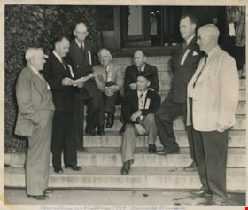
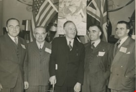
Convention in Victoria 1949 Burnaby Council
https://search.heritageburnaby.ca/link/archivedescription55612
- Repository
- City of Burnaby Archives
- Date
- 1949
- Collection/Fonds
- Charles MacSorley fonds
- Description Level
- Item
- Physical Description
- 1 photograph : b&w ; 20.5 x 25 cm
- Scope and Content
- Photograph of eight men identified as Burnaby's Municipal Council sitting and standing on a stone staircase outside an unidentified building in Victoria. Written across the bottom of the photograph is: "Convention in Victoria 1949 Burnaby Council." Identified in the picture are Reeve George Morri…
- Repository
- City of Burnaby Archives
- Date
- 1949
- Collection/Fonds
- Charles MacSorley fonds
- Physical Description
- 1 photograph : b&w ; 20.5 x 25 cm
- Description Level
- Item
- Record No.
- 486-006
- Access Restriction
- No restrictions
- Reproduction Restriction
- Reproduce for fair dealing purposes only
- Accession Number
- 2005-14
- Scope and Content
- Photograph of eight men identified as Burnaby's Municipal Council sitting and standing on a stone staircase outside an unidentified building in Victoria. Written across the bottom of the photograph is: "Convention in Victoria 1949 Burnaby Council." Identified in the picture are Reeve George Morrison (third from the left), Charles MacSorley (fifth from the left, seated in back), Doug Drummond (seated in front of Charles MacSorley) and William Beamish (second from right).
- Subjects
- Officials - Alderman and Councillors
- Names
- Morrison, George
- MacSorley, Charles W.
- Drummond, John D. "Doug"
- Beamish, William Randolph "Ran"
- Media Type
- Photograph
- Photographer
- Halkett, Bill
- Notes
- Title based on caption
- Photographer's stamp on verso
Images

![Ron Smitherman, [199-]. Item no. 549-065. thumbnail](/media/hpo/_Data/_Archives_Images/_Unrestricted/540/549-065.jpg?width=280)
Interview with Ron Smitherman by Eric Damer November 15, 2012 - Track 3
https://search.heritageburnaby.ca/link/oralhistory405
- Repository
- City of Burnaby Archives
- Date Range
- 1949-2012
- Length
- 0:07:25
- Summary
- This portion of the recording pertains to Ron Smitherman's memories of the postwar construction boom in comparison to the modern day. Ron discusses the changes in construction practices which lead to the leaky condo phenomenon.
- Repository
- City of Burnaby Archives
- Summary
- This portion of the recording pertains to Ron Smitherman's memories of the postwar construction boom in comparison to the modern day. Ron discusses the changes in construction practices which lead to the leaky condo phenomenon.
- Date Range
- 1949-2012
- Photo Info
- Ron Smitherman, [199-]. Item no. 549-065.
- Length
- 0:07:25
- Subjects
- Construction
- Buildings - Residences
- Interviewer
- Damer, Eric
- Interview Date
- November 15, 2012
- Scope and Content
- Recording is an interview with Ron Smitherman conducted by Burnaby Village Museum employee Eric Damer, November 15, 2012. Major theme discussed: building construction and development in Burnaby.
- Biographical Notes
- Born in 1933 and raised in Vancouver, Ron Smitherman learned the construction trade from his father, upgrading his knowledge and skills as techniques and materials changed and improved. Ron built houses and commercial buildings in Burnaby and elsewhere during the nineteen-forties, fifties and sixties. In 1969 Ron and his family settled in Burnaby where he shifted his business to real estate.
- Total Tracks
- 6
- Total Length
- 0:46:51
- Interviewee Name
- Smitherman, Ron
- Interview Location
- Burnaby Village Museum
- Interviewer Bio
- Eric Damer is a lifelong British Columbian born in Victoria, raised in Kamloops, and currently residing in Burnaby. After studying philosophy at the University of Victoria, he became interested in the educational forces that had shaped his own life. He completed master’s and doctoral degrees in educational studies at the University of British Columbia with a particular interest in the history of adult and higher education in the province. In 2012, Eric worked for the City of Burnaby as a field researcher and writer, conducting interviews for the City Archives and Museum Oral History Program.
- Collection/Fonds
- Community Heritage Commission Special Projects fonds
- Transcript Available
- None
- Media Type
- Sound Recording
Images
![Ron Smitherman, [199-]. Item no. 549-065. thumbnail](/media/hpo/_Data/_Archives_Images/_Unrestricted/540/549-065.jpg)
Audio Tracks
Track three of recording of interview with Ron Smitherman
Track three of recording of interview with Ron Smitherman
https://search.heritageburnaby.ca/media/hpo/_Data/_Archives_Oral_Histories/_Unrestricted/MSS171-025/MSS171-025_Track_3.mp3
Interview with Ron Smitherman by Eric Damer November 15, 2012 - Track 4
https://search.heritageburnaby.ca/link/oralhistory406
- Repository
- City of Burnaby Archives
- Date Range
- 1949-2012
- Length
- 0:09:51
- Summary
- This portion of the recording pertains to Ron Smitherman's memories of changes to construction regulations over the years. Ron discusses Burnaby's industrial construction during the postwar era and beyond. He explains environmental and municipal regulations in relation to common practices within th…
- Repository
- City of Burnaby Archives
- Summary
- This portion of the recording pertains to Ron Smitherman's memories of changes to construction regulations over the years. Ron discusses Burnaby's industrial construction during the postwar era and beyond. He explains environmental and municipal regulations in relation to common practices within the construction industry.
- Date Range
- 1949-2012
- Photo Info
- Ron Smitherman, [199-]. Item no. 549-065.
- Length
- 0:09:51
- Subjects
- Construction
- Buildings - Industrial
- Interviewer
- Damer, Eric
- Interview Date
- November 15, 2012
- Scope and Content
- Recording is an interview with Ron Smitherman conducted by Burnaby Village Museum employee Eric Damer, November 15, 2012. Major theme discussed: building construction and development in Burnaby.
- Biographical Notes
- Born in 1933 and raised in Vancouver, Ron Smitherman learned the construction trade from his father, upgrading his knowledge and skills as techniques and materials changed and improved. Ron built houses and commercial buildings in Burnaby and elsewhere during the nineteen-forties, fifties and sixties. In 1969 Ron and his family settled in Burnaby where he shifted his business to real estate.
- Total Tracks
- 6
- Total Length
- 0:46:51
- Interviewee Name
- Smitherman, Ron
- Interview Location
- Burnaby Village Museum
- Interviewer Bio
- Eric Damer is a lifelong British Columbian born in Victoria, raised in Kamloops, and currently residing in Burnaby. After studying philosophy at the University of Victoria, he became interested in the educational forces that had shaped his own life. He completed master’s and doctoral degrees in educational studies at the University of British Columbia with a particular interest in the history of adult and higher education in the province. In 2012, Eric worked for the City of Burnaby as a field researcher and writer, conducting interviews for the City Archives and Museum Oral History Program.
- Collection/Fonds
- Community Heritage Commission Special Projects fonds
- Transcript Available
- None
- Media Type
- Sound Recording
Images
Audio Tracks
Track four of recording of interview with Ron Smitherman
Track four of recording of interview with Ron Smitherman
https://search.heritageburnaby.ca/media/hpo/_Data/_Archives_Oral_Histories/_Unrestricted/MSS171-025/MSS171-025_Track_4.mp3
Interview with Ron Smitherman by Eric Damer November 15, 2012 - Track 5
https://search.heritageburnaby.ca/link/oralhistory407
- Repository
- City of Burnaby Archives
- Date Range
- 1949-2010
- Length
- 0:04:54
- Summary
- This portion of the recording pertains to Ron Smitherman's memories of construction regulations and public policies that made Burnaby unique. Ron discusses the impact of paved lanes and unusual lot widths.
- Repository
- City of Burnaby Archives
- Summary
- This portion of the recording pertains to Ron Smitherman's memories of construction regulations and public policies that made Burnaby unique. Ron discusses the impact of paved lanes and unusual lot widths.
- Date Range
- 1949-2010
- Photo Info
- Ron Smitherman, [199-]. Item no. 549-065.
- Length
- 0:04:54
- Subjects
- Construction
- Interviewer
- Damer, Eric
- Interview Date
- November 15, 2012
- Scope and Content
- Recording is an interview with Ron Smitherman conducted by Burnaby Village Museum employee Eric Damer, November 15, 2012. Major theme discussed: building construction and development in Burnaby.
- Biographical Notes
- Born in 1933 and raised in Vancouver, Ron Smitherman learned the construction trade from his father, upgrading his knowledge and skills as techniques and materials changed and improved. Ron built houses and commercial buildings in Burnaby and elsewhere during the nineteen-forties, fifties and sixties. In 1969 Ron and his family settled in Burnaby where he shifted his business to real estate.
- Total Tracks
- 6
- Total Length
- 0:46:51
- Interviewee Name
- Smitherman, Ron
- Interview Location
- Burnaby Village Museum
- Interviewer Bio
- Eric Damer is a lifelong British Columbian born in Victoria, raised in Kamloops, and currently residing in Burnaby. After studying philosophy at the University of Victoria, he became interested in the educational forces that had shaped his own life. He completed master’s and doctoral degrees in educational studies at the University of British Columbia with a particular interest in the history of adult and higher education in the province. In 2012, Eric worked for the City of Burnaby as a field researcher and writer, conducting interviews for the City Archives and Museum Oral History Program.
- Collection/Fonds
- Community Heritage Commission Special Projects fonds
- Transcript Available
- None
- Media Type
- Sound Recording
Images
Audio Tracks
Track five of recording of interview with Ron Smitherman
Track five of recording of interview with Ron Smitherman
https://search.heritageburnaby.ca/media/hpo/_Data/_Archives_Oral_Histories/_Unrestricted/MSS171-025/MSS171-025_Track_5.mp3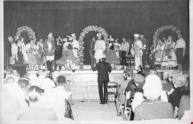
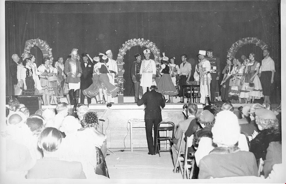
Aperetto "Pirates" Spring performance
https://search.heritageburnaby.ca/link/archivedescription97575
- Repository
- City of Burnaby Archives
- Date
- 1949
- Collection/Fonds
- Burnaby Historical Society fonds
- Description Level
- File
- Physical Description
- 11 photographs : b&w
- Scope and Content
- File consists of photographs of the Aperetto "Pirates" Spring performance from 1949 and cast members portraits taken in costume. File also contains a photographic portrait of Joe Ternent and Elanor Cailes in the Cailes' garden at Roswell
- Repository
- City of Burnaby Archives
- Date
- 1949
- Collection/Fonds
- Burnaby Historical Society fonds
- Subseries
- Burnaby Clef Society subseries
- Physical Description
- 11 photographs : b&w
- Description Level
- File
- Record No.
- 142-009
- Reproduction Restriction
- Reproduce for fair dealing purposes only
- Accession Number
- BHS1985-12
- Scope and Content
- File consists of photographs of the Aperetto "Pirates" Spring performance from 1949 and cast members portraits taken in costume. File also contains a photographic portrait of Joe Ternent and Elanor Cailes in the Cailes' garden at Roswell
- Names
- Burnaby Clef Society
- Media Type
- Photograph
- Notes
- Title based on contents of file
- Photographer's stamp on verso of 142-009-1, 142-009-10, and 142-009-11 reads: "Photographed by L.C. Cailes, R.R.1, Boswell, BC Negative No. [blank]".
- Negative number "4" is written in black ink on verso of 142-009-10.
- Note in pencil written on verso of 142-009-11 reads: "Joe Ternent and Eleanor Cailes in Cailes garden at Roswell".
- Photographer's stamp on verso of 142-009-2:142-009- reads: "Pacific Photo Service 2802 McGill Street Residence Phone HA. 2129 M"
- Photographer's stamp on verso of 142-009-2. First reads: "Your Flash Photo by F. Fallan HA. 2129 M Reprint Order No. 8". Second reads:
- Note in blue ink on verso of 142-009-3 reads: "6"
- Photographer's stamp on verso of 142-009-4 reads: "Your Flash Photo by F. Fallan HA. 2129 M Reprint Order No. 5".
- Photographer's stamp on verso of 142-009-5 reads: "Your Flash Photo by F. Fallan HA. 2129 M Reprint Order No. 10".
- Photographer's stamp on verso of 142-009-6 reads: "Your Flash Photo by F. Fallan HA. 2129 M Reprint Order No. 11".
- Photographer's stamp on verso of 142-009-7 reads: "Your Flash Photo by F. Fallan HA. 2129 M Reprint Order No. 7".
- Photographer's stamp on verso of 142-009-8 reads: "Your Flash Photo by F. Fallan HA. 2129 M Reprint Order No. 4".
- Photographer's stamp on verso of 142-009-9 reads: "Your Flash Photo by F. Fallan HA. 2129 M Reprint Order No. 9".
Images
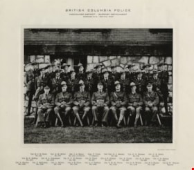
British Columbia Police
https://search.heritageburnaby.ca/link/archivedescription34562
- Repository
- City of Burnaby Archives
- Date
- May 7, 1949
- Collection/Fonds
- Burnaby Historical Society fonds
- Description Level
- Item
- Physical Description
- 1 photograph : b&w ; 19.2 x 24.6 cm mounted on 30.4 x 35.5 cm cardboard
- Scope and Content
- Photograph of the British Columbia Provincial Police, Burnaby Detachment at Burnaby Municipal Hall. The caption above the photograph reads, "British Columbia Police / Vancouver District - Burnaby Detachment / Burnaby, B.C. - May 7th, 1949. The members are, front row, left to right: Cpl. R.C.B Foo…
- Repository
- City of Burnaby Archives
- Date
- May 7, 1949
- Collection/Fonds
- Burnaby Historical Society fonds
- Subseries
- Photographs subseries
- Physical Description
- 1 photograph : b&w ; 19.2 x 24.6 cm mounted on 30.4 x 35.5 cm cardboard
- Description Level
- Item
- Record No.
- 049-001
- Access Restriction
- No restrictions
- Reproduction Restriction
- Reproduce for fair dealing purposes only
- Accession Number
- BHS2007-04
- Scope and Content
- Photograph of the British Columbia Provincial Police, Burnaby Detachment at Burnaby Municipal Hall. The caption above the photograph reads, "British Columbia Police / Vancouver District - Burnaby Detachment / Burnaby, B.C. - May 7th, 1949. The members are, front row, left to right: Cpl. R.C.B Foote (No. 215), Cpl. A.M. Millar (No. 575), Sgt. J.A. Henry (No. 414 i/c Detach.), Insp. C. Clark (i/c District), Det./Cpl. G.J. Emsley (No. 509), Cpl. G.S. Pearson (No. 579), and Cst. C.E. Estlin (No. 914). Middle row, left to right: Cst. R.G. McKay (No. 1071), Cst. B.L. Johannson (No. 1019), Cst. N.C.B. Nelson (No. 733), Cst. H. Twist (No. 607), Cst. A.E. Gibbon (No. 947), Cst. E. Turtle (No. 959), Cst. H.E. Klick (No. 923), and Cst. J.H. Bishop (No. 1031). Back row, left to right: Cst. S. Service (No. 1152), Cst. J. McCowan (No. 1133), Cst. L. Brown (No. 1150), Cst. J.E. Clark (No. 1142), Cst. L.J. Tabbutt (No. 1053), Cst. V.H. St. Pierce (No. 1153), Cst. D.N. Brown (No. 1149), Cst. B.O. Mayne (No. 1136), and Cst. Q.W. Wenaus (Special).
- Names
- Bishop, J.H.
- British Columbia Provincial Police
- Brown, Donald N. "Don"
- Brown, L.
- Clark, J.E.
- Clarke, C.
- Emsley, G.J.
- Estlin, C.E.
- Foote, R.C.B.
- Gibbon, A.E.
- Henry, J.A.
- Johannson, B.L.
- Klick, H.E.
- Mayne, B.O.
- McCowan, J.
- McKay, R.G.
- Millar, A.M.
- Nelson, N.C.B.
- Pearson, G.S.
- Service, S.
- St. Pierce, V.H.
- Tabbutt, L.J.
- Turtle, Eric
- Twist, H.
- Wenaus, Q.W.
- Media Type
- Photograph
- Photographer
- Balkin, Jack
- Geographic Access
- Kingsway
- Street Address
- 7282 Kingsway
- Historic Neighbourhood
- Edmonds (Historic Neighbourhood)
- Planning Study Area
- Stride Avenue Area
Images

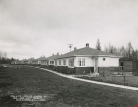
New Vista Society Project
https://search.heritageburnaby.ca/link/archivedescription34646
- Repository
- City of Burnaby Archives
- Date
- 1949
- Collection/Fonds
- Burnaby Historical Society fonds
- Description Level
- Item
- Physical Description
- 1 photograph : b&w ; 19.9 x 25.0 cm
- Scope and Content
- Photograph of the New Vista Society housing project no. 1 at 900 to 952 Vista Crescent (later renumbered 7590 to 7510 Vista Crescent).
- Repository
- City of Burnaby Archives
- Date
- 1949
- Collection/Fonds
- Burnaby Historical Society fonds
- Subseries
- Photographs subseries
- Physical Description
- 1 photograph : b&w ; 19.9 x 25.0 cm
- Description Level
- Item
- Record No.
- 080-001
- Access Restriction
- No restrictions
- Reproduction Restriction
- Reproduce for fair dealing purposes only
- Accession Number
- BHS2007-04
- Scope and Content
- Photograph of the New Vista Society housing project no. 1 at 900 to 952 Vista Crescent (later renumbered 7590 to 7510 Vista Crescent).
- Subjects
- Buildings - Residential - Houses
- Names
- New Vista Society
- Media Type
- Photograph
- Photographer
- Stride, Charles Edgar
- Notes
- Title based on contents of photograph
- Caption at bottom left of photograph, "New Vista Society's Project #1. 900 - 952 Vista Crescent, South Burnaby, B.C., 1949"
- Stamp and annotation on back of photograph reads, "Photo by The Stride Studios / 657 Columbia Street, New Westminster, BC" and "#6084"
- Geographic Access
- Vista Crescent
- Historic Neighbourhood
- Edmonds (Historic Neighbourhood)
- Planning Study Area
- Richmond Park Area
Images

![George A. Morrison, [1949] (date of original), copied [1995] thumbnail](/media/hpo/_Data/_Archives_Images/_Unrestricted/126/126-016.jpg?width=280)
George A. Morrison
https://search.heritageburnaby.ca/link/archivedescription34741
- Repository
- City of Burnaby Archives
- Date
- [1949] (date of original), copied [1995]
- Collection/Fonds
- Burnaby Historical Society fonds
- Description Level
- Item
- Physical Description
- 1 photograph : b&w ; 17.1 x 12.0 cm print
- Scope and Content
- Photograph (mounted and titled) of George A. Morrison, Reeve of Burnaby from 1945 to 1949 and Council member in 1944.
- Repository
- City of Burnaby Archives
- Date
- [1949] (date of original), copied [1995]
- Collection/Fonds
- Burnaby Historical Society fonds
- Subseries
- Photographs subseries
- Physical Description
- 1 photograph : b&w ; 17.1 x 12.0 cm print
- Description Level
- Item
- Record No.
- 126-016
- Access Restriction
- No restrictions
- Reproduction Restriction
- Reproduce for fair dealing purposes only
- Accession Number
- BHS2007-04
- Scope and Content
- Photograph (mounted and titled) of George A. Morrison, Reeve of Burnaby from 1945 to 1949 and Council member in 1944.
- Names
- Morrison, George
- Media Type
- Photograph
- Notes
- Title based on contents of photograph
Images
![George A. Morrison, [1949] (date of original), copied [1995] thumbnail](/media/hpo/_Data/_Archives_Images/_Unrestricted/126/126-016.jpg)
![North Burnaby from Hythe Avenue, [1949] thumbnail](/media/hpo/_Data/_Archives_Images/_Unrestricted/126/161-004.jpg?width=280)
North Burnaby from Hythe Avenue
https://search.heritageburnaby.ca/link/archivedescription34929
- Repository
- City of Burnaby Archives
- Date
- [1949]
- Collection/Fonds
- Burnaby Historical Society fonds
- Description Level
- Item
- Physical Description
- 1 photograph : b&w ; 9.1 x 12.6 cm
- Scope and Content
- Photograph taken looking west from Hythe Avenue, between Empire Drive and Dundas, towards north Burnaby.
- Repository
- City of Burnaby Archives
- Date
- [1949]
- Collection/Fonds
- Burnaby Historical Society fonds
- Subseries
- Marjorie Coe subseries
- Physical Description
- 1 photograph : b&w ; 9.1 x 12.6 cm
- Description Level
- Item
- Record No.
- 161-004
- Access Restriction
- No restrictions
- Reproduction Restriction
- Reproduce for fair dealing purposes only
- Accession Number
- BHS1986-11
- Scope and Content
- Photograph taken looking west from Hythe Avenue, between Empire Drive and Dundas, towards north Burnaby.
- Subjects
- Geographic Features - Neighbourhoods
- Media Type
- Photograph
- Notes
- Title based on contents of photograph
- Item no. 161-004, 161-005 and 161-006 join to form a panorama
- Geographic Access
- Hythe Avenue
- Historic Neighbourhood
- Capitol Hill (Historic Neighbourhood)
- Planning Study Area
- Capitol Hill Area
Images
![North Burnaby from Hythe Avenue, [1949] thumbnail](/media/hpo/_Data/_Archives_Images/_Unrestricted/126/161-004.jpg)
![North Burnaby from Hythe Avenue, [1949] thumbnail](/media/hpo/_Data/_Archives_Images/_Unrestricted/126/161-005.jpg?width=280)
North Burnaby from Hythe Avenue
https://search.heritageburnaby.ca/link/archivedescription34930
- Repository
- City of Burnaby Archives
- Date
- [1949]
- Collection/Fonds
- Burnaby Historical Society fonds
- Description Level
- Item
- Physical Description
- 1 photograph : b&w ; 8.9 x 12.6 cm
- Scope and Content
- Photograph taken looking west from Hythe Avenue towards north Burnaby.
- Repository
- City of Burnaby Archives
- Date
- [1949]
- Collection/Fonds
- Burnaby Historical Society fonds
- Subseries
- Marjorie Coe subseries
- Physical Description
- 1 photograph : b&w ; 8.9 x 12.6 cm
- Description Level
- Item
- Record No.
- 161-005
- Access Restriction
- No restrictions
- Reproduction Restriction
- Reproduce for fair dealing purposes only
- Accession Number
- BHS1986-11
- Scope and Content
- Photograph taken looking west from Hythe Avenue towards north Burnaby.
- Subjects
- Geographic Features - Neighbourhoods
- Media Type
- Photograph
- Notes
- Title based on contents of photograph
- Items no. 161-004, 161-005 and 161-006 join to form a panorama
- Geographic Access
- Hythe Avenue
- Historic Neighbourhood
- Capitol Hill (Historic Neighbourhood)
- Planning Study Area
- Capitol Hill Area
Images
![North Burnaby from Hythe Avenue, [1949] thumbnail](/media/hpo/_Data/_Archives_Images/_Unrestricted/126/161-005.jpg)
![North Burnaby from Hythe Avenue, [1949] thumbnail](/media/hpo/_Data/_Archives_Images/_Unrestricted/126/161-006.jpg?width=280)
North Burnaby from Hythe Avenue
https://search.heritageburnaby.ca/link/archivedescription34931
- Repository
- City of Burnaby Archives
- Date
- [1949]
- Collection/Fonds
- Burnaby Historical Society fonds
- Description Level
- Item
- Physical Description
- 1 photograph : b&w ; 8.9 x 12.6 cm
- Scope and Content
- Photograph taken looking west from Hythe Avenue towards north Burnaby. Burrard Inlet is also visible.
- Repository
- City of Burnaby Archives
- Date
- [1949]
- Collection/Fonds
- Burnaby Historical Society fonds
- Subseries
- Marjorie Coe subseries
- Physical Description
- 1 photograph : b&w ; 8.9 x 12.6 cm
- Description Level
- Item
- Record No.
- 161-006
- Access Restriction
- No restrictions
- Reproduction Restriction
- Reproduce for fair dealing purposes only
- Accession Number
- BHS1986-11
- Scope and Content
- Photograph taken looking west from Hythe Avenue towards north Burnaby. Burrard Inlet is also visible.
- Media Type
- Photograph
- Notes
- Title based on contents of photograph
- Items no. 161-004, 161-005 and 161-006 join to form a panorama
- Geographic Access
- Hythe Avenue
- Historic Neighbourhood
- Capitol Hill (Historic Neighbourhood)
- Planning Study Area
- Capitol Hill Area
Images
![North Burnaby from Hythe Avenue, [1949] thumbnail](/media/hpo/_Data/_Archives_Images/_Unrestricted/126/161-006.jpg)
![Mr. and Mrs. E. Chamberlain, [ca. 1949] (date of original), copied 1986 thumbnail](/media/hpo/_Data/_Archives_Images/_Unrestricted/126/179-009.jpg?width=280)
Mr. and Mrs. E. Chamberlain
https://search.heritageburnaby.ca/link/archivedescription35038
- Repository
- City of Burnaby Archives
- Date
- [ca. 1949] (date of original), copied 1986
- Collection/Fonds
- Burnaby Historical Society fonds
- Description Level
- Item
- Physical Description
- 1 photograph : b&w ; 12.6 x 8.7 cm print
- Scope and Content
- Photograph shows Mr. and Mrs. E. Chamberlain in a truck on Elgin Avenue.
- Repository
- City of Burnaby Archives
- Date
- [ca. 1949] (date of original), copied 1986
- Collection/Fonds
- Burnaby Historical Society fonds
- Subseries
- Chamberlain family subseries
- Physical Description
- 1 photograph : b&w ; 12.6 x 8.7 cm print
- Description Level
- Item
- Record No.
- 179-009
- Access Restriction
- No restrictions
- Reproduction Restriction
- Reproduce for fair dealing purposes only
- Accession Number
- BHS1986-27
- Scope and Content
- Photograph shows Mr. and Mrs. E. Chamberlain in a truck on Elgin Avenue.
- Subjects
- Transportation - Automobiles
- Names
- Chamberlain, Earnest
- Media Type
- Photograph
- Notes
- Title based on contents of photograph
- Geographic Access
- Elgin Avenue
- Historic Neighbourhood
- Central Park (Historic Neighbourhood)
- Planning Study Area
- Windsor Area
Images
![Mr. and Mrs. E. Chamberlain, [ca. 1949] (date of original), copied 1986 thumbnail](/media/hpo/_Data/_Archives_Images/_Unrestricted/126/179-009.jpg)

Matheson and Sons Market
https://search.heritageburnaby.ca/link/archivedescription35041
- Repository
- City of Burnaby Archives
- Date
- 1949 (date of original), copied 1986
- Collection/Fonds
- Burnaby Historical Society fonds
- Description Level
- Item
- Physical Description
- 1 photograph : col. ; 8.6 x 12.7 cm print
- Scope and Content
- Photograph of the exterior of A. Matheson and Sons Market at 3576 Kingsway (later renumbered 4920 Kingsway) and Nelson Avenue. Signs on the building read, "A. Matheson & Sons Market," "Fresh Meats - Groceries," "Quality and Service," "Dexter 1372 1373," and "Free Delivery." Signs advertising pric…
- Repository
- City of Burnaby Archives
- Date
- 1949 (date of original), copied 1986
- Collection/Fonds
- Burnaby Historical Society fonds
- Subseries
- Chamberlain family subseries
- Physical Description
- 1 photograph : col. ; 8.6 x 12.7 cm print
- Description Level
- Item
- Record No.
- 179-012
- Access Restriction
- No restrictions
- Reproduction Restriction
- Reproduce for fair dealing purposes only
- Accession Number
- BHS1986-27
- Scope and Content
- Photograph of the exterior of A. Matheson and Sons Market at 3576 Kingsway (later renumbered 4920 Kingsway) and Nelson Avenue. Signs on the building read, "A. Matheson & Sons Market," "Fresh Meats - Groceries," "Quality and Service," "Dexter 1372 1373," and "Free Delivery." Signs advertising prices are outside the store. A sign by the street lights reads, "Signals set for 29 mph." Cars can be seen. This store was previously owned and operated by Alexander MacKenzie.
- Media Type
- Photograph
- Notes
- Title based on contents of photograph
- Print made from col. slide
- Geographic Access
- Kingsway
- Street Address
- 4920 Kingsway
- Historic Neighbourhood
- Central Park (Historic Neighbourhood)
- Planning Study Area
- Marlborough Area
Images


Matheson and Sons Market
https://search.heritageburnaby.ca/link/archivedescription35042
- Repository
- City of Burnaby Archives
- Date
- 1949 (date of original), copied 1986
- Collection/Fonds
- Burnaby Historical Society fonds
- Description Level
- Item
- Physical Description
- 1 photograph : col. ; 8.8 x 12.6 cm print
- Scope and Content
- Photograph of the exterior of A. Matheson and Sons Market at 3576 Kingsway (later renumbered 4920 Kingsway) and Nelson Avenue. Signs on the building read, "A. Matheson & Sons Market," "Fresh Meats - Groceries," "Quality and Service," "Dexter 1372 1373," and "Free Delivery." Signs advertising pric…
- Repository
- City of Burnaby Archives
- Date
- 1949 (date of original), copied 1986
- Collection/Fonds
- Burnaby Historical Society fonds
- Subseries
- Chamberlain family subseries
- Physical Description
- 1 photograph : col. ; 8.8 x 12.6 cm print
- Description Level
- Item
- Record No.
- 179-013
- Access Restriction
- No restrictions
- Reproduction Restriction
- Reproduce for fair dealing purposes only
- Accession Number
- BHS1986-27
- Scope and Content
- Photograph of the exterior of A. Matheson and Sons Market at 3576 Kingsway (later renumbered 4920 Kingsway) and Nelson Avenue. Signs on the building read, "A. Matheson & Sons Market," "Fresh Meats - Groceries," "Quality and Service," "Dexter 1372 1373," and "Free Delivery." Signs advertising prices are outside the store. A sign by the street lights reads, "Signals set for 29 mph." This store was previously owned and operated by Alexander MacKenzie.
- Media Type
- Photograph
- Notes
- Title based on contents of photograph
- Print made from col. slide
- Geographic Access
- Kingsway
- Street Address
- 4920 Kingsway
- Historic Neighbourhood
- Central Park (Historic Neighbourhood)
- Planning Study Area
- Marlborough Area
Images


Armstrong Avenue School
https://search.heritageburnaby.ca/link/archivedescription35043
- Repository
- City of Burnaby Archives
- Date
- 1949 (date of original), copied 1986
- Collection/Fonds
- Burnaby Historical Society fonds
- Description Level
- Item
- Physical Description
- 1 photograph : col. ; 8.8 x 12.5 cm print
- Scope and Content
- Photograph of the exterior of Armstrong Avenue School in the snow. A car is parked outside.
- Repository
- City of Burnaby Archives
- Date
- 1949 (date of original), copied 1986
- Collection/Fonds
- Burnaby Historical Society fonds
- Subseries
- Chamberlain family subseries
- Physical Description
- 1 photograph : col. ; 8.8 x 12.5 cm print
- Description Level
- Item
- Record No.
- 179-014
- Access Restriction
- No restrictions
- Reproduction Restriction
- Reproduce for fair dealing purposes only
- Accession Number
- BHS1986-27
- Scope and Content
- Photograph of the exterior of Armstrong Avenue School in the snow. A car is parked outside.
- Names
- Armstrong Avenue School
- Media Type
- Photograph
- Notes
- Title based on contents of photograph
- Print made from col. slide
- Geographic Access
- Armstrong Avenue
- Street Address
- 8757 Armstrong Avenue
- Historic Neighbourhood
- East Burnaby (Historic Neighbourhood)
- Planning Study Area
- Cariboo-Armstrong Area
Images


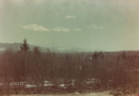
Taken from Armstrong Avenue School
https://search.heritageburnaby.ca/link/archivedescription35044
- Repository
- City of Burnaby Archives
- Date
- 1949 (date of original), copied 1986
- Collection/Fonds
- Burnaby Historical Society fonds
- Description Level
- Item
- Physical Description
- 1 photograph : col. ; 8.8 x 12.5 cm print
- Scope and Content
- Photograph taken from an Armstrong Avenue School classroom. An annotation on the back of the photograph reads, "View from the second floor of Armstrong Ave School looking North to Burnaby Lake, 1949."
- Repository
- City of Burnaby Archives
- Date
- 1949 (date of original), copied 1986
- Collection/Fonds
- Burnaby Historical Society fonds
- Subseries
- Chamberlain family subseries
- Physical Description
- 1 photograph : col. ; 8.8 x 12.5 cm print
- Description Level
- Item
- Record No.
- 179-015
- Access Restriction
- No restrictions
- Reproduction Restriction
- Reproduce for fair dealing purposes only
- Accession Number
- BHS1986-27
- Scope and Content
- Photograph taken from an Armstrong Avenue School classroom. An annotation on the back of the photograph reads, "View from the second floor of Armstrong Ave School looking North to Burnaby Lake, 1949."
- Subjects
- Plants - Trees
- Names
- Armstrong Avenue School
- Media Type
- Photograph
- Notes
- Title based on contents of photograph
- Print made from col. slide
- Geographic Access
- Armstrong Avenue
- Street Address
- 8757 Armstrong Avenue
- Historic Neighbourhood
- East Burnaby (Historic Neighbourhood)
- Planning Study Area
- Cariboo-Armstrong Area
Images
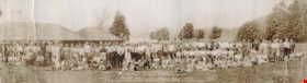
Burnaby Civic Employees Picnic
https://search.heritageburnaby.ca/link/archivedescription35135
- Repository
- City of Burnaby Archives
- Date
- 1949
- Collection/Fonds
- Burnaby Historical Society fonds
- Description Level
- Item
- Physical Description
- 1 photograph : b&w ; 20.2 x 79.0 cm
- Scope and Content
- Photograph of a group of men, women and children at a Burnaby Civic Employees Picnic at Belcarra Park. Some of the people identified in the photograph are: Judith Hunter Conners, Ann Grover, Ed Engberg, John Fredrick Grover, David Hunter, Phyllis Hunter, Jim Grover, Sid [Dote?], possibly Charlie Fo…
- Repository
- City of Burnaby Archives
- Date
- 1949
- Collection/Fonds
- Burnaby Historical Society fonds
- Subseries
- Burnaby Civic Employees subseries
- Physical Description
- 1 photograph : b&w ; 20.2 x 79.0 cm
- Description Level
- Item
- Record No.
- 198-001
- Access Restriction
- No restrictions
- Reproduction Restriction
- No restrictions
- Accession Number
- BHS1987-09
- Scope and Content
- Photograph of a group of men, women and children at a Burnaby Civic Employees Picnic at Belcarra Park. Some of the people identified in the photograph are: Judith Hunter Conners, Ann Grover, Ed Engberg, John Fredrick Grover, David Hunter, Phyllis Hunter, Jim Grover, Sid [Dote?], possibly Charlie Fothergill, and possibly Mrs. Fothergill. An annotation at the bottom centre of photograph reads, "Burnaby Civic Employees / Picnic Belcarra Park July 1949," and at the bottom right of the photo, "Sunday's Photos."
- Names
- Conners, Judith Hunter
- Engberg, Ed
- Fothergill, Charlie
- Grover, Ann
- Grover, Jim
- Grover, John Fredrick
- Hunter, David
- Hunter, Phyllis
- Burnaby Civic Employees Union
- Media Type
- Photograph
- Photographer
- Sunday, Fred William
- Notes
- Title based on contents of photograph
Images

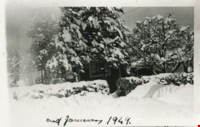
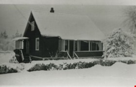
Shankie family home
https://search.heritageburnaby.ca/link/archivedescription35145
- Repository
- City of Burnaby Archives
- Date
- January 1949 (date of original), copied 1986
- Collection/Fonds
- Burnaby Historical Society fonds
- Description Level
- Item
- Physical Description
- 1 photograph : b&w ; 12.7 x 17.8 cm print
- Scope and Content
- Photograph of "Campend," the Shankie family home. This photograph was taken following winter snows. The house was formerly numbered 3718 Barker Avenue and later renumbered 5155 Barker Avenue.
- Repository
- City of Burnaby Archives
- Date
- January 1949 (date of original), copied 1986
- Collection/Fonds
- Burnaby Historical Society fonds
- Subseries
- Pioneer Tales subseries
- Physical Description
- 1 photograph : b&w ; 12.7 x 17.8 cm print
- Description Level
- Item
- Record No.
- 204-002
- Access Restriction
- No restrictions
- Reproduction Restriction
- Reproduce for fair dealing purposes only
- Accession Number
- BHS1988-03
- Scope and Content
- Photograph of "Campend," the Shankie family home. This photograph was taken following winter snows. The house was formerly numbered 3718 Barker Avenue and later renumbered 5155 Barker Avenue.
- Subjects
- Natural Phenomena - Snow
- Media Type
- Photograph
- Notes
- Title based on contents of photograph
- Geographic Access
- Barker Avenue
- Street Address
- 5155 Barker Avenue
- Historic Neighbourhood
- Central Park (Historic Neighbourhood)
- Planning Study Area
- Garden Village Area
Images

Cowan family home
https://search.heritageburnaby.ca/link/archivedescription35194
- Repository
- City of Burnaby Archives
- Date
- January 1949
- Collection/Fonds
- Burnaby Historical Society fonds
- Description Level
- Item
- Physical Description
- 1 photograph : b&w ; 12.7 x 17.8 cm print
- Scope and Content
- Photograph of the Cowan family home, 2930 Gilpin Street (later renumbered 5926 Gilpin Street),taken after a big snowfall.
- Repository
- City of Burnaby Archives
- Date
- January 1949
- Collection/Fonds
- Burnaby Historical Society fonds
- Subseries
- Pioneer Tales subseries
- Physical Description
- 1 photograph : b&w ; 12.7 x 17.8 cm print
- Description Level
- Item
- Record No.
- 204-051
- Access Restriction
- No restrictions
- Reproduction Restriction
- Reproduce for fair dealing purposes only
- Accession Number
- BHS1988-03
- Scope and Content
- Photograph of the Cowan family home, 2930 Gilpin Street (later renumbered 5926 Gilpin Street),taken after a big snowfall.
- Media Type
- Photograph
- Notes
- Title based on contents of photograph
- Geographic Access
- Gilpin Street
- Street Address
- 5926 Gilpin Street
- Historic Neighbourhood
- Burnaby Lake (Historic Neighbourhood)
- Planning Study Area
- Douglas-Gilpin Area
Images

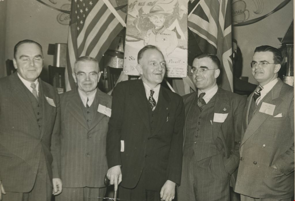
Grant men with Tom Corbett
https://search.heritageburnaby.ca/link/archivedescription36302
- Repository
- City of Burnaby Archives
- Date
- February 1949
- Collection/Fonds
- Burnaby Historical Society fonds
- Description Level
- Item
- Physical Description
- 1 photograph : b&w ; 11.5 x 16.5 cm
- Scope and Content
- Photograph of son William T. Grant, and father George A. Grant honouring Scoutmaster Tom Corbett with sons George Grant and Heriot H. Grant.
- Repository
- City of Burnaby Archives
- Date
- February 1949
- Collection/Fonds
- Burnaby Historical Society fonds
- Subseries
- George Grant subseries
- Physical Description
- 1 photograph : b&w ; 11.5 x 16.5 cm
- Description Level
- Item
- Record No.
- 243-022
- Access Restriction
- No restrictions
- Reproduction Restriction
- Reproduce for fair dealing purposes only
- Accession Number
- BHS1990-06
- Scope and Content
- Photograph of son William T. Grant, and father George A. Grant honouring Scoutmaster Tom Corbett with sons George Grant and Heriot H. Grant.
- Names
- Grant, William "Bill"
- Grant, George Jr.
- Grant, George Alford
- Grant, Heriot "Harry"
- Corbett, Thomas "Tom"
- Media Type
- Photograph
- Notes
- Title based on contents of photograph
Images