Narrow Results By
Subject
- Accidents 10
- Accidents - Automobile Accidents 26
- Accidents - Train Accidents 8
- Adornment - Jewelry 3
- Adornment - Lapel Pins 1
- Advertising Medium 10
- Advertising Medium - Signs and Signboards
- Aerial Photographs 88
- Agricultural Tools and Equipment 16
- Agricultural Tools and Equipment - Cultivators 1
- Agricultural Tools and Equipment - Gardening Equipment 10
- Agricultural Tools and Equipment - Plows 9
Person / Organization
- A & Aero Trading Salvage 1
- Admiral Hotel 2
- A. MacKenzie and Company Jubilee Store 3
- Anthony, Bill 1
- Astor Hotel 3
- Blue Mountain Flower and Garden Shop 1
- Bonsor Recreation Complex 1
- Bowker, A.D. 1
- British Columbia Hydro and Power Authority 2
- Burnaby Art Gallery 1
- Burnaby Chamber of Commerce 1
- Burnaby Christian Supply 1

Sussex Villa
https://search.heritageburnaby.ca/link/archivedescription98659
- Repository
- City of Burnaby Archives
- Date
- 2022
- Collection/Fonds
- Disappearing Burnaby collection
- Description Level
- Item
- Physical Description
- 1 photograph (jpeg) : col.
- Scope and Content
- Photograph of part of the exterior and front lawn of Sussex Villa, an apartment complex located at 6620-6630 Sussex Avenue, at night. The building was constructed in 1965 and is set to be developed into a high-rise tower by Keltic Canada Development. A light is on inside one of the apartment window…
- Repository
- City of Burnaby Archives
- Date
- 2022
- Collection/Fonds
- Disappearing Burnaby collection
- Physical Description
- 1 photograph (jpeg) : col.
- Description Level
- Item
- Record No.
- 634-006
- Access Restriction
- No restrictions
- Reproduction Restriction
- No restrictions
- Accession Number
- 2022-14
- Scope and Content
- Photograph of part of the exterior and front lawn of Sussex Villa, an apartment complex located at 6620-6630 Sussex Avenue, at night. The building was constructed in 1965 and is set to be developed into a high-rise tower by Keltic Canada Development. A light is on inside one of the apartment windows and a sign for the "Metrotown - Regional Town Centre Notification of Area Plan" stands on the lawn.
- Subjects
- Buildings - Residential - Apartments
- Buildings - Residential
- Advertising Medium - Signs and Signboards
- Planning - City Planning
- Media Type
- Photograph
- Photographer
- Cheung, Nakita
- Notes
- Title taken from the associated blog post
- Associated blog post: https://disappearingburnaby.wordpress.com/2022/01/29/sussex-villa-2/
- Geographic Access
- Sussex Avenue
- Street Address
- 6620 Sussex Avenue
- 6630 Sussex Avenue
- Historic Neighbourhood
- Central Park (Historic Neighbourhood)
- Planning Study Area
- Maywood Area
Images


Sussex Villa with sign
https://search.heritageburnaby.ca/link/archivedescription98660
- Repository
- City of Burnaby Archives
- Date
- 2022
- Collection/Fonds
- Disappearing Burnaby collection
- Description Level
- Item
- Physical Description
- 1 photograph (jpeg) : col.
- Scope and Content
- Photograph of part of the exterior and front lawn of Sussex Villa, an apartment complex located at 6620-6630 Sussex Avenue, at night. The building was constructed in 1965 and is set to be developed into a high-rise tower by Keltic Canada Development. A sign standing on the lawn reads: "Land Loan" a…
- Repository
- City of Burnaby Archives
- Date
- 2022
- Collection/Fonds
- Disappearing Burnaby collection
- Physical Description
- 1 photograph (jpeg) : col.
- Description Level
- Item
- Record No.
- 634-007
- Access Restriction
- No restrictions
- Reproduction Restriction
- No restrictions
- Accession Number
- 2022-14
- Scope and Content
- Photograph of part of the exterior and front lawn of Sussex Villa, an apartment complex located at 6620-6630 Sussex Avenue, at night. The building was constructed in 1965 and is set to be developed into a high-rise tower by Keltic Canada Development. A sign standing on the lawn reads: "Land Loan" and "Domain Funding" with contact information, and a residential tower is visible in the background.
- Subjects
- Buildings - Residential - Apartments
- Buildings - Residential
- Advertising Medium - Signs and Signboards
- Media Type
- Photograph
- Photographer
- Cheung, Nakita
- Notes
- Title taken from the associated blog post
- Associated blog post: https://disappearingburnaby.wordpress.com/2022/01/29/sussex-villa-2/
- Geographic Access
- Sussex Avenue
- Street Address
- 6620 Sussex Avenue
- 6630 Sussex Avenue
- Historic Neighbourhood
- Central Park (Historic Neighbourhood)
- Planning Study Area
- Maywood Area
Images


Martello Group sign at 6615 Telford Avenue
https://search.heritageburnaby.ca/link/archivedescription98675
- Repository
- City of Burnaby Archives
- Date
- 2022
- Collection/Fonds
- Disappearing Burnaby collection
- Description Level
- Item
- Physical Description
- 1 photograph (jpeg) : col.
- Scope and Content
- Photograph of a sign, which reads "Professionally Managed by Martello," on the lawn of an apartment building located at 6615 Telford Avenue. The building was constructed in 1964. Other residential towers, a construction crane, and cars parked along Telford Avenue are visible in the background.
- Repository
- City of Burnaby Archives
- Date
- 2022
- Collection/Fonds
- Disappearing Burnaby collection
- Physical Description
- 1 photograph (jpeg) : col.
- Description Level
- Item
- Record No.
- 634-022
- Access Restriction
- No restrictions
- Reproduction Restriction
- No restrictions
- Accession Number
- 2022-14
- Scope and Content
- Photograph of a sign, which reads "Professionally Managed by Martello," on the lawn of an apartment building located at 6615 Telford Avenue. The building was constructed in 1964. Other residential towers, a construction crane, and cars parked along Telford Avenue are visible in the background.
- Subjects
- Buildings - Residential
- Buildings - Residential - Apartments
- Advertising Medium - Signs and Signboards
- Media Type
- Photograph
- Photographer
- Cheung, Nakita
- Notes
- Title taken from the associated blog post
- Associated blog post: https://disappearingburnaby.wordpress.com/2022/06/09/martello-group/
- Geographic Access
- Telford Avenue
- Street Address
- 6615 Telford Avenue
- Historic Neighbourhood
- Central Park (Historic Neighbourhood)
- Planning Study Area
- Maywood Area
Images


Star Light Apartments sign
https://search.heritageburnaby.ca/link/archivedescription98677
- Repository
- City of Burnaby Archives
- Date
- 2022
- Collection/Fonds
- Disappearing Burnaby collection
- Description Level
- Item
- Physical Description
- 1 photograph (jpeg) : col.
- Scope and Content
- Photograph of the Blue Sky Investments Ltd.'s sign on the lawn of Star Light Apartments, a low-rise apartment building located at 6555 Telford Avenue. The building was constructed in 1964. The photograph depicts the scene at dusk; the building's entrance is visible to the left, with its exterior li…
- Repository
- City of Burnaby Archives
- Date
- 2022
- Collection/Fonds
- Disappearing Burnaby collection
- Physical Description
- 1 photograph (jpeg) : col.
- Description Level
- Item
- Record No.
- 634-024
- Access Restriction
- No restrictions
- Reproduction Restriction
- No restrictions
- Accession Number
- 2022-14
- Scope and Content
- Photograph of the Blue Sky Investments Ltd.'s sign on the lawn of Star Light Apartments, a low-rise apartment building located at 6555 Telford Avenue. The building was constructed in 1964. The photograph depicts the scene at dusk; the building's entrance is visible to the left, with its exterior lights on, and Telford Avenue and other neighbouring towers are visible in the background.
- Subjects
- Buildings - Residential
- Buildings - Residential - Apartments
- Advertising Medium - Signs and Signboards
- Media Type
- Photograph
- Photographer
- Cheung, Nakita
- Notes
- Title taken from the associated blog post
- Associated blog post: https://disappearingburnaby.wordpress.com/2022/06/24/star-light-apartments/
- Geographic Access
- Telford Avenue
- Street Address
- 6555 Telford Avenue
- Historic Neighbourhood
- Central Park (Historic Neighbourhood)
- Planning Study Area
- Marlborough Area
Images


Lost in the 50's Drive-In sign
https://search.heritageburnaby.ca/link/archivedescription98682
- Repository
- City of Burnaby Archives
- Date
- 2022
- Collection/Fonds
- Disappearing Burnaby collection
- Description Level
- Item
- Physical Description
- 1 photograph (jpeg) : col.
- Scope and Content
- Photograph of the historic "Arrow Neon Sign" at 50's Burgers, a restaurant located at 7741 Edmonds Street. The photograph depicts the sign, which reads: "Lost in the 50's Drive-In," against the sky at dusk.
- Repository
- City of Burnaby Archives
- Date
- 2022
- Collection/Fonds
- Disappearing Burnaby collection
- Physical Description
- 1 photograph (jpeg) : col.
- Description Level
- Item
- Record No.
- 634-029
- Access Restriction
- No restrictions
- Reproduction Restriction
- No restrictions
- Accession Number
- 2022-14
- Scope and Content
- Photograph of the historic "Arrow Neon Sign" at 50's Burgers, a restaurant located at 7741 Edmonds Street. The photograph depicts the sign, which reads: "Lost in the 50's Drive-In," against the sky at dusk.
- Media Type
- Photograph
- Photographer
- Cheung, Nakita
- Notes
- Title taken from the associated blog post
- Associated blog post: https://disappearingburnaby.wordpress.com/2022/06/30/lost-in-the-50s-drive-in/
- Geographic Access
- Edmonds Street
- Street Address
- 7741 Edmonds Street
- Historic Neighbourhood
- East Burnaby (Historic Neighbourhood)
- Planning Study Area
- Lakeview-Mayfield Area
Images


Do Your Part Eagle
https://search.heritageburnaby.ca/link/archivedescription95084
- Repository
- City of Burnaby Archives
- Date
- June 13, 2020
- Collection/Fonds
- Burnaby Photographic Society fonds
- Description Level
- Item
- Physical Description
- 1 photograph (tiff)
- Scope and Content
- Photograph of a sign along the Burnaby Lake Freeway Trail that reads: "Do your part. Stay 2 metres apart." The sign has a silhoutte drawing of an eagle with its wings open to illustrate the distance of two metres.
- Repository
- City of Burnaby Archives
- Date
- June 13, 2020
- Collection/Fonds
- Burnaby Photographic Society fonds
- Physical Description
- 1 photograph (tiff)
- Description Level
- Item
- Record No.
- 623-003
- Access Restriction
- No restrictions
- Reproduction Restriction
- No restrictions
- Accession Number
- 2020-10
- Scope and Content
- Photograph of a sign along the Burnaby Lake Freeway Trail that reads: "Do your part. Stay 2 metres apart." The sign has a silhoutte drawing of an eagle with its wings open to illustrate the distance of two metres.
- Media Type
- Photograph
- Photographer
- Gervan, Bonnie
- Notes
- Transcribed title
- Photographer's caption: "A sign shows how far to keep apart."
- Geographic Access
- Burnaby Lake Regional Nature Park
- Historic Neighbourhood
- Burnaby Lake (Historic Neighbourhood)
- Planning Study Area
- Burnaby Lake Area
Images

Vet Hospital
https://search.heritageburnaby.ca/link/archivedescription95086
- Repository
- City of Burnaby Archives
- Date
- June 13, 2020
- Collection/Fonds
- Burnaby Photographic Society fonds
- Description Level
- Item
- Physical Description
- 1 photograph (tiff)
- Scope and Content
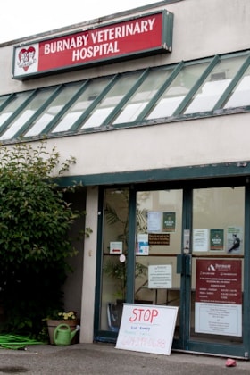
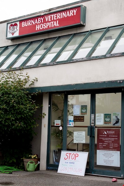
- Photograph of the exterior of the Burnaby Veterinarian Hospital. A whiteboard is propped up against the door of the hospital with a notice prohibiting visitors from entering and requesting they call for entry.
- Repository
- City of Burnaby Archives
- Date
- June 13, 2020
- Collection/Fonds
- Burnaby Photographic Society fonds
- Physical Description
- 1 photograph (tiff)
- Description Level
- Item
- Record No.
- 623-005
- Access Restriction
- No restrictions
- Reproduction Restriction
- No restrictions
- Accession Number
- 2020-10
- Scope and Content
- Photograph of the exterior of the Burnaby Veterinarian Hospital. A whiteboard is propped up against the door of the hospital with a notice prohibiting visitors from entering and requesting they call for entry.
- Media Type
- Photograph
- Photographer
- Gervan, Bonnie
- Notes
- Transcribed title
- Photographer's caption: "Sign says “Stop, No Entry, Please Call”. Staff will come out to accept the non human clients outside and bring them in for their appointment."
- Geographic Access
- Springer Avenue
- Street Address
- 2210 Springer Avenue
- Planning Study Area
- Ardingley-Sprott Area
Images

Cheap Gas during Covid Pandemic
https://search.heritageburnaby.ca/link/archivedescription95087
- Repository
- City of Burnaby Archives
- Date
- April 27, 2020
- Collection/Fonds
- Burnaby Photographic Society fonds
- Description Level
- Item
- Physical Description
- 1 photograph (tiff)
- Scope and Content
- Photograph of a Chevron Gas Station sign advertising gas for 85.9 cents per litre. The Chevron station is located at 6138 Kingsway.
- Repository
- City of Burnaby Archives
- Date
- April 27, 2020
- Collection/Fonds
- Burnaby Photographic Society fonds
- Physical Description
- 1 photograph (tiff)
- Description Level
- Item
- Record No.
- 623-006
- Access Restriction
- No restrictions
- Reproduction Restriction
- Reproduce for fair dealing purposes only
- Accession Number
- 2020-10
- Scope and Content
- Photograph of a Chevron Gas Station sign advertising gas for 85.9 cents per litre. The Chevron station is located at 6138 Kingsway.
- Media Type
- Photograph
- Photographer
- Asbia, Cher
- Notes
- Transcribed title
- Photographer's caption: "Huge drop in gas prices for a few weeks only"
- Geographic Access
- Kingsway
- Street Address
- 6138 Kingsway
- Planning Study Area
- Clinton-Glenwood Area
Images


Social distance in Burnaby Parks
https://search.heritageburnaby.ca/link/archivedescription95093
- Repository
- City of Burnaby Archives
- Date
- May 8, 2020
- Collection/Fonds
- Burnaby Photographic Society fonds
- Description Level
- Item
- Physical Description
- 1 photograph (tiff)
- Scope and Content
- Photograph of a City of Burnaby sign encouraging social distancing attached to a tree in Mary Avenue Park.
- Repository
- City of Burnaby Archives
- Date
- May 8, 2020
- Collection/Fonds
- Burnaby Photographic Society fonds
- Physical Description
- 1 photograph (tiff)
- Description Level
- Item
- Record No.
- 623-012
- Access Restriction
- No restrictions
- Reproduction Restriction
- Reproduce for fair dealing purposes only
- Accession Number
- 2020-10
- Scope and Content
- Photograph of a City of Burnaby sign encouraging social distancing attached to a tree in Mary Avenue Park.
- Media Type
- Photograph
- Photographer
- Asbia, Cher
- Notes
- Transcribed title
- Geographic Access
- 12th Avenue
- Historic Neighbourhood
- Edmonds (Historic Neighbourhood)
- Planning Study Area
- Edmonds Area
Images


Burnaby hospital closes main entrance
https://search.heritageburnaby.ca/link/archivedescription95094
- Repository
- City of Burnaby Archives
- Date
- April 6, 2020
- Collection/Fonds
- Burnaby Photographic Society fonds
- Description Level
- Item
- Physical Description
- 1 photograph (tiff)
- Scope and Content
- Photograph of a rerouting sign posted to a sandwich board outside the Burnaby Hospital emergency lot. The sign states that the hospital entrance is closed and requests visitors use the Main Entrance of the hospital.
- Repository
- City of Burnaby Archives
- Date
- April 6, 2020
- Collection/Fonds
- Burnaby Photographic Society fonds
- Physical Description
- 1 photograph (tiff)
- Description Level
- Item
- Record No.
- 623-013
- Access Restriction
- No restrictions
- Reproduction Restriction
- No restrictions
- Accession Number
- 2020-10
- Scope and Content
- Photograph of a rerouting sign posted to a sandwich board outside the Burnaby Hospital emergency lot. The sign states that the hospital entrance is closed and requests visitors use the Main Entrance of the hospital.
- Subjects
- Buildings - Civic - Hospitals
- Geographic Features - Automobile Parking Lots
- Advertising Medium - Signs and Signboards
- Media Type
- Photograph
- Photographer
- Damer, Eric
- Notes
- Transcribed title
- Geographic Access
- Kincaid Street
- Street Address
- 3935 Kincaid Street
- Historic Neighbourhood
- Broadview (Historic Neighbourhood)
- Planning Study Area
- Cascade-Schou Area
Images


New regulations at work site
https://search.heritageburnaby.ca/link/archivedescription95095
- Repository
- City of Burnaby Archives
- Date
- April 16, 2020
- Collection/Fonds
- Burnaby Photographic Society fonds
- Description Level
- Item
- Physical Description
- 1 photograph (tiff)
- Scope and Content
- Photograph of signs attached to security fencing outside the closed Schou Education Centre on Canada Way. Signs are handwritten and contain COVID-19 site safety protocols. Photograph was taken from Norfolk Street, facing south.
- Repository
- City of Burnaby Archives
- Date
- April 16, 2020
- Collection/Fonds
- Burnaby Photographic Society fonds
- Physical Description
- 1 photograph (tiff)
- Description Level
- Item
- Record No.
- 623-014
- Access Restriction
- No restrictions
- Reproduction Restriction
- No restrictions
- Accession Number
- 2020-10
- Scope and Content
- Photograph of signs attached to security fencing outside the closed Schou Education Centre on Canada Way. Signs are handwritten and contain COVID-19 site safety protocols. Photograph was taken from Norfolk Street, facing south.
- Media Type
- Photograph
- Photographer
- Damer, Eric
- Notes
- Transcribed title
- Geographic Access
- Gilmore Avenue
- Canada Way
- Street Address
- 4054 Norfolk Street
- Historic Neighbourhood
- Broadview (Historic Neighbourhood)
- Planning Study Area
- Cascade-Schou Area
Images


Swangard Stadium closed
https://search.heritageburnaby.ca/link/archivedescription95096
- Repository
- City of Burnaby Archives
- Date
- April 21, 2020
- Collection/Fonds
- Burnaby Photographic Society fonds
- Description Level
- Item
- Physical Description
- 1 photograph (tiff)
- Scope and Content
- Photograph of two City of Burnaby signs attached to fencing outside Swangard Stadium in Central Park. The signs announce the facility's closure in response to the COVID-19 pandemic. Behind the fencing, the stadium's track and bleachers are visible.
- Repository
- City of Burnaby Archives
- Date
- April 21, 2020
- Collection/Fonds
- Burnaby Photographic Society fonds
- Physical Description
- 1 photograph (tiff)
- Description Level
- Item
- Record No.
- 623-015
- Access Restriction
- No restrictions
- Reproduction Restriction
- No restrictions
- Accession Number
- 2020-10
- Scope and Content
- Photograph of two City of Burnaby signs attached to fencing outside Swangard Stadium in Central Park. The signs announce the facility's closure in response to the COVID-19 pandemic. Behind the fencing, the stadium's track and bleachers are visible.
- Names
- Swangard Stadium
- Media Type
- Photograph
- Photographer
- Damer, Eric
- Notes
- Transcribed title
- Geographic Access
- Central Park
- Imperial Street
- Street Address
- 3883 Imperial Street
- Historic Neighbourhood
- Central Park (Historic Neighbourhood)
- Planning Study Area
- Maywood Area
Images


Radical sentiments
https://search.heritageburnaby.ca/link/archivedescription95098
- Repository
- City of Burnaby Archives
- Date
- April 29, 2020
- Collection/Fonds
- Burnaby Photographic Society fonds
- Description Level
- Item
- Physical Description
- 1 photograph (tiff)
- Scope and Content
- Photograph of a Socialist Alternative "Fight Coronavirus & Fight Capitalism" sign posted to a telephone poll near the BCIT campus.
- Repository
- City of Burnaby Archives
- Date
- April 29, 2020
- Collection/Fonds
- Burnaby Photographic Society fonds
- Physical Description
- 1 photograph (tiff)
- Description Level
- Item
- Record No.
- 623-017
- Access Restriction
- No restrictions
- Reproduction Restriction
- No restrictions
- Accession Number
- 2020-10
- Scope and Content
- Photograph of a Socialist Alternative "Fight Coronavirus & Fight Capitalism" sign posted to a telephone poll near the BCIT campus.
- Media Type
- Photograph
- Photographer
- Damer, Eric
- Notes
- Transcribed title
- Geographic Access
- Willingdon Avenue
- Sanderson Way
- Planning Study Area
- Cascade-Schou Area
Images


Hopeful sign on Smith Ave
https://search.heritageburnaby.ca/link/archivedescription95099
- Repository
- City of Burnaby Archives
- Date
- March 21, 2020
- Collection/Fonds
- Burnaby Photographic Society fonds
- Description Level
- Item
- Physical Description
- 1 photograph (tiff)
- Scope and Content
- Photograph of a bright pink sign stapled to a telphone poll on Smith Avenue near Wakefield Court. A smiling green creature is painted on the sign along with the message "Stay Happy Stay Healthy!".
- Repository
- City of Burnaby Archives
- Date
- March 21, 2020
- Collection/Fonds
- Burnaby Photographic Society fonds
- Physical Description
- 1 photograph (tiff)
- Description Level
- Item
- Record No.
- 623-018
- Access Restriction
- No restrictions
- Reproduction Restriction
- No restrictions
- Accession Number
- 2020-10
- Scope and Content
- Photograph of a bright pink sign stapled to a telphone poll on Smith Avenue near Wakefield Court. A smiling green creature is painted on the sign along with the message "Stay Happy Stay Healthy!".
- Media Type
- Photograph
- Photographer
- Damer, Eric
- Notes
- Transcribed title
- Geographic Access
- Smith Avenue
- Planning Study Area
- Cascade-Schou Area
Images


Central Park testing station
https://search.heritageburnaby.ca/link/archivedescription95101
- Repository
- City of Burnaby Archives
- Date
- May 9, 2020
- Collection/Fonds
- Burnaby Photographic Society fonds
- Description Level
- Item
- Physical Description
- 1 photograph (tiff)
- Scope and Content
- Photograph of the COVID-19 testing station located in the Central Park parking lot off Boundary Road. A sign in the foreground reads "Covid-19 Care Site by Referral Only / Walk in Access". In the background, the white tents of the testing station are visible.
- Repository
- City of Burnaby Archives
- Date
- May 9, 2020
- Collection/Fonds
- Burnaby Photographic Society fonds
- Physical Description
- 1 photograph (tiff)
- Description Level
- Item
- Record No.
- 623-019
- Access Restriction
- No restrictions
- Reproduction Restriction
- No restrictions
- Accession Number
- 2020-10
- Scope and Content
- Photograph of the COVID-19 testing station located in the Central Park parking lot off Boundary Road. A sign in the foreground reads "Covid-19 Care Site by Referral Only / Walk in Access". In the background, the white tents of the testing station are visible.
- Subjects
- Geographic Features - Parks
- Geographic Features - Automobile Parking Lots
- Advertising Medium - Signs and Signboards
- Structures - Tents
- Media Type
- Photograph
- Photographer
- Damer, Eric
- Notes
- Transcribed title
- Geographic Access
- Boundary Road
- Central Park
- Historic Neighbourhood
- Central Park (Historic Neighbourhood)
- Planning Study Area
- Maywood Area
Images


Confederation park playground closure
https://search.heritageburnaby.ca/link/archivedescription95102
- Repository
- City of Burnaby Archives
- Date
- April 29, 2020
- Collection/Fonds
- Burnaby Photographic Society fonds
- Description Level
- Item
- Physical Description
- 1 photograph (tiff)
- Scope and Content
- Photograph of a City of Burnaby facility closure sign at Confederation Park. Sign is attached to security fencing closing off the playground equipment at the park.
- Repository
- City of Burnaby Archives
- Date
- April 29, 2020
- Collection/Fonds
- Burnaby Photographic Society fonds
- Physical Description
- 1 photograph (tiff)
- Description Level
- Item
- Record No.
- 623-020
- Access Restriction
- No restrictions
- Reproduction Restriction
- No restrictions
- Accession Number
- 2020-10
- Scope and Content
- Photograph of a City of Burnaby facility closure sign at Confederation Park. Sign is attached to security fencing closing off the playground equipment at the park.
- Media Type
- Photograph
- Photographer
- King, Gloria
- Notes
- Transcribed title
- Geographic Access
- Albert Street
- Confederation Park
- Planning Study Area
- Capitol Hill Area
Images


Dr. Bonny Henry’s mantra, Burnaby North Sec School
https://search.heritageburnaby.ca/link/archivedescription95103
- Repository
- City of Burnaby Archives
- Date
- April 30, 2020
- Collection/Fonds
- Burnaby Photographic Society fonds
- Description Level
- Item
- Physical Description
- 1 photograph (tiff)
- Scope and Content
- Photograph of a man standing beside a marquee at Burnaby North Secondary School that reads "Be Kind Be Calm Be Safe". The man is wearing a yellow baseball hat, respirator mask, and white latex gloves.
- Repository
- City of Burnaby Archives
- Date
- April 30, 2020
- Collection/Fonds
- Burnaby Photographic Society fonds
- Physical Description
- 1 photograph (tiff)
- Description Level
- Item
- Record No.
- 623-021
- Access Restriction
- No restrictions
- Reproduction Restriction
- No restrictions
- Accession Number
- 2020-10
- Scope and Content
- Photograph of a man standing beside a marquee at Burnaby North Secondary School that reads "Be Kind Be Calm Be Safe". The man is wearing a yellow baseball hat, respirator mask, and white latex gloves.
- Media Type
- Photograph
- Photographer
- King, Gloria
- Notes
- Transcribed title
- Photographer's caption: "Burnaby North Sec School-Quote from Dr. Bonnie Henry"
- Geographic Access
- Hammarskjold Drive
- Street Address
- 751 Hammarskjold Drive
- Planning Study Area
- Parkcrest-Aubrey Area
Images


Civic Protocols
https://search.heritageburnaby.ca/link/archivedescription95104
- Repository
- City of Burnaby Archives
- Date
- April 30, 2020
- Collection/Fonds
- Burnaby Photographic Society fonds
- Description Level
- Item
- Physical Description
- 1 photograph (tiff)
- Scope and Content
- Photograph of a marquee at Burnaby North Secondary School that reads "Wash Your Hands Stay 2M Apart".
- Repository
- City of Burnaby Archives
- Date
- April 30, 2020
- Collection/Fonds
- Burnaby Photographic Society fonds
- Physical Description
- 1 photograph (tiff)
- Description Level
- Item
- Record No.
- 623-022
- Access Restriction
- No restrictions
- Reproduction Restriction
- No restrictions
- Accession Number
- 2020-10
- Scope and Content
- Photograph of a marquee at Burnaby North Secondary School that reads "Wash Your Hands Stay 2M Apart".
- Media Type
- Photograph
- Photographer
- King, Gloria
- Notes
- Transcribed title
- Geographic Access
- Hammarskjold Drive
- Street Address
- 751 Hammarskjold Drive
- Planning Study Area
- Parkcrest-Aubrey Area
Images


Physical distancing sign
https://search.heritageburnaby.ca/link/archivedescription95106
- Repository
- City of Burnaby Archives
- Date
- 2020
- Collection/Fonds
- Burnaby Photographic Society fonds
- Description Level
- Item
- Physical Description
- 1 photograph (tiff)
- Scope and Content
- Photograph of the gardens outside the Shadbolt Centre of the Arts. In the foreground, attached to a tree is a sign encouraging social distancing; in the background is a jungle gym fenced off with orange mesh and caution tape to prohibit climbing.
- Repository
- City of Burnaby Archives
- Date
- 2020
- Collection/Fonds
- Burnaby Photographic Society fonds
- Physical Description
- 1 photograph (tiff)
- Description Level
- Item
- Record No.
- 623-024
- Access Restriction
- No restrictions
- Reproduction Restriction
- No restrictions
- Accession Number
- 2020-10
- Scope and Content
- Photograph of the gardens outside the Shadbolt Centre of the Arts. In the foreground, attached to a tree is a sign encouraging social distancing; in the background is a jungle gym fenced off with orange mesh and caution tape to prohibit climbing.
- Media Type
- Photograph
- Photographer
- King, Gloria
- Notes
- Transcribed title
- Geographic Access
- Deer Lake
- Street Address
- 6450 Deer Lake Avenue
- Historic Neighbourhood
- Burnaby Lake (Historic Neighbourhood)
- Planning Study Area
- Douglas-Gilpin Area
Images


Cash till line up
https://search.heritageburnaby.ca/link/archivedescription95107
- Repository
- City of Burnaby Archives
- Date
- April 27, 2020
- Collection/Fonds
- Burnaby Photographic Society fonds
- Description Level
- Item
- Physical Description
- 1 photograph (tiff)
- Scope and Content
- Photograph of shoppers in the checkout lines at Save-On-Foods grocery store at the Old Orchard Shopping Centre. On the floor are red decals indicating where shoppers should stand to maintain distance from one another. The decals read: "Allow 2M between shoppers".
- Repository
- City of Burnaby Archives
- Date
- April 27, 2020
- Collection/Fonds
- Burnaby Photographic Society fonds
- Physical Description
- 1 photograph (tiff)
- Description Level
- Item
- Record No.
- 623-025
- Access Restriction
- No restrictions
- Reproduction Restriction
- No restrictions
- Accession Number
- 2020-10
- Scope and Content
- Photograph of shoppers in the checkout lines at Save-On-Foods grocery store at the Old Orchard Shopping Centre. On the floor are red decals indicating where shoppers should stand to maintain distance from one another. The decals read: "Allow 2M between shoppers".
- Media Type
- Photograph
- Photographer
- Snowdon, Nick
- Notes
- Transcribed title
- Photographer's caption: "Physical distancing signs become common in most stores"
- Geographic Access
- Kingsway
- Street Address
- 4429 Kingsway
- Historic Neighbourhood
- Central Park (Historic Neighbourhood)
- Planning Study Area
- Garden Village Area
Images


One way only
https://search.heritageburnaby.ca/link/archivedescription95108
- Repository
- City of Burnaby Archives
- Date
- April 27, 2020
- Collection/Fonds
- Burnaby Photographic Society fonds
- Description Level
- Item
- Physical Description
- 1 photograph (tiff)
- Scope and Content
- Photograph of the baking aisle in Save-On-Foods grocery store. A large red decal on the floor reads "STOP please enter aisle from other end".
- Repository
- City of Burnaby Archives
- Date
- April 27, 2020
- Collection/Fonds
- Burnaby Photographic Society fonds
- Physical Description
- 1 photograph (tiff)
- Description Level
- Item
- Record No.
- 623-026
- Access Restriction
- No restrictions
- Reproduction Restriction
- No restrictions
- Accession Number
- 2020-10
- Scope and Content
- Photograph of the baking aisle in Save-On-Foods grocery store. A large red decal on the floor reads "STOP please enter aisle from other end".
- Media Type
- Photograph
- Photographer
- Snowdon, Nick
- Notes
- Transcribed title
- Photographer's caption: "One way system imposed in store. Not everyone obeys"
- Geographic Access
- Kingsway
- Street Address
- 4429 Kingsway
- Historic Neighbourhood
- Central Park (Historic Neighbourhood)
- Planning Study Area
- Garden Village Area
Images


One person per household
https://search.heritageburnaby.ca/link/archivedescription95109
- Repository
- City of Burnaby Archives
- Date
- April 27, 2020
- Collection/Fonds
- Burnaby Photographic Society fonds
- Description Level
- Item
- Physical Description
- 1 photograph (tiff)
- Scope and Content
- Photograph of the entrance at Save-On-Foods grocery store. One of the two doors at the entrance is blocked by a freestanding sign that reads: "To prevent the spread of COVID-19 Limit 1 person per household". Next to the sign is a shopping cart with signage attached to it informing shoppers that r…
- Repository
- City of Burnaby Archives
- Date
- April 27, 2020
- Collection/Fonds
- Burnaby Photographic Society fonds
- Physical Description
- 1 photograph (tiff)
- Description Level
- Item
- Record No.
- 623-027
- Access Restriction
- No restrictions
- Reproduction Restriction
- No restrictions
- Accession Number
- 2020-10
- Scope and Content
- Photograph of the entrance at Save-On-Foods grocery store. One of the two doors at the entrance is blocked by a freestanding sign that reads: "To prevent the spread of COVID-19 Limit 1 person per household". Next to the sign is a shopping cart with signage attached to it informing shoppers that reusable and cloth bags are prohibited in the store.
- Media Type
- Photograph
- Photographer
- Snowdon, Nick
- Notes
- Transcribed title
- Photographer's caption: "Early on in the pandemic, stores limit number of people from one household. This does not last very long."
- Geographic Access
- Kingsway
- Street Address
- 4429 Kingsway
- Historic Neighbourhood
- Central Park (Historic Neighbourhood)
- Planning Study Area
- Garden Village Area
Images


No playing here
https://search.heritageburnaby.ca/link/archivedescription95110
- Repository
- City of Burnaby Archives
- Date
- April 24, 2020
- Collection/Fonds
- Burnaby Photographic Society fonds
- Description Level
- Item
- Physical Description
- 1 photograph (tiff)
- Scope and Content
- Photograph of playground equipment taped off with caution tape at Royal Oakland Park. A red City of Burnaby facility closure sign posted to the playground is visible through the top of a slide.
- Repository
- City of Burnaby Archives
- Date
- April 24, 2020
- Collection/Fonds
- Burnaby Photographic Society fonds
- Physical Description
- 1 photograph (tiff)
- Description Level
- Item
- Record No.
- 623-028
- Access Restriction
- No restrictions
- Reproduction Restriction
- No restrictions
- Accession Number
- 2020-10
- Scope and Content
- Photograph of playground equipment taped off with caution tape at Royal Oakland Park. A red City of Burnaby facility closure sign posted to the playground is visible through the top of a slide.
- Media Type
- Photograph
- Photographer
- Snowdon, Nick
- Notes
- Transcribed title
- Photographer's caption: "Most playgrounds are taped off"
- Geographic Access
- Oakmount Crescent
- Historic Neighbourhood
- Central Park (Historic Neighbourhood)
- Planning Study Area
- Windsor Area
Images


Temporary one way at Deer Lake Park
https://search.heritageburnaby.ca/link/archivedescription95111
- Repository
- City of Burnaby Archives
- Date
- April 10, 2020
- Collection/Fonds
- Burnaby Photographic Society fonds
- Description Level
- Item
- Physical Description
- 1 photograph (tiff)
- Scope and Content
- Photograph of a sign detailing a temporary one-way walking route for Deer Lake Park. The sign is posted at the Royal Oak entrance of the park.
- Repository
- City of Burnaby Archives
- Date
- April 10, 2020
- Collection/Fonds
- Burnaby Photographic Society fonds
- Physical Description
- 1 photograph (tiff)
- Description Level
- Item
- Record No.
- 623-029
- Access Restriction
- No restrictions
- Reproduction Restriction
- No restrictions
- Accession Number
- 2020-10
- Scope and Content
- Photograph of a sign detailing a temporary one-way walking route for Deer Lake Park. The sign is posted at the Royal Oak entrance of the park.
- Media Type
- Photograph
- Photographer
- Snowdon, Nick
- Notes
- Transcribed title
- Photographer's caption: "Big signs show the one way system at Deer Lake. The signs are not detailed and lead to some confusion. Other signs are spread throughout the park including spay paint on the trails."
- Geographic Access
- Deer Lake Park
- Planning Study Area
- Windsor Area
Images


Basketball Court Closed
https://search.heritageburnaby.ca/link/archivedescription95116
- Repository
- City of Burnaby Archives
- Date
- May 8, 2020
- Collection/Fonds
- Burnaby Photographic Society fonds
- Description Level
- Item
- Physical Description
- 1 photograph (tiff)
- Scope and Content
- Photograph of a closed basketball court at Edmonds Park. A City of Burnaby facility closure sign is attached to the fence outside the court and the basketball hoops are covered with thick orange netting.
- Repository
- City of Burnaby Archives
- Date
- May 8, 2020
- Collection/Fonds
- Burnaby Photographic Society fonds
- Physical Description
- 1 photograph (tiff)
- Description Level
- Item
- Record No.
- 623-034
- Access Restriction
- No restrictions
- Reproduction Restriction
- No restrictions
- Accession Number
- 2020-10
- Scope and Content
- Photograph of a closed basketball court at Edmonds Park. A City of Burnaby facility closure sign is attached to the fence outside the court and the basketball hoops are covered with thick orange netting.
- Media Type
- Photograph
- Photographer
- Peterman, Randall
- Notes
- Transcribed title
- Geographic Access
- Humphries Avenue
- Street Address
- 7433 Humphries Avenue
- Historic Neighbourhood
- Edmonds (Historic Neighbourhood)
- Planning Study Area
- Richmond Park Area
Images


Coin Counting Machine
https://search.heritageburnaby.ca/link/archivedescription95117
- Repository
- City of Burnaby Archives
- Date
- May 27, 2020
- Collection/Fonds
- Burnaby Photographic Society fonds
- Description Level
- Item
- Physical Description
- 1 photograph (tiff)
- Scope and Content
- Photograph of a coin counter at Vancity Credit Union on Kingsway. Signs taped to the machine state that the machine is closed due to COVID-19 health warnings.
- Repository
- City of Burnaby Archives
- Date
- May 27, 2020
- Collection/Fonds
- Burnaby Photographic Society fonds
- Physical Description
- 1 photograph (tiff)
- Description Level
- Item
- Record No.
- 623-035
- Access Restriction
- No restrictions
- Reproduction Restriction
- No restrictions
- Accession Number
- 2020-10
- Scope and Content
- Photograph of a coin counter at Vancity Credit Union on Kingsway. Signs taped to the machine state that the machine is closed due to COVID-19 health warnings.
- Media Type
- Photograph
- Photographer
- Peterman, Randall
- Notes
- Transcribed title
- Geographic Access
- Kingsway
- Street Address
- 5064 Kingsway
- Historic Neighbourhood
- Central Park (Historic Neighbourhood)
- Planning Study Area
- Marlborough Area
Images


Joey Restaurant
https://search.heritageburnaby.ca/link/archivedescription95118
- Repository
- City of Burnaby Archives
- Date
- April 1, 2020
- Collection/Fonds
- Burnaby Photographic Society fonds
- Description Level
- Item
- Physical Description
- 1 photograph (tiff)
- Scope and Content
- Photograph of a sign perched on a decorative tree trunk in the foyer of Joey Burnaby. The sign contains information for patrons on food delivery and pickup.
- Repository
- City of Burnaby Archives
- Date
- April 1, 2020
- Collection/Fonds
- Burnaby Photographic Society fonds
- Physical Description
- 1 photograph (tiff)
- Description Level
- Item
- Record No.
- 623-036
- Access Restriction
- No restrictions
- Reproduction Restriction
- No restrictions
- Accession Number
- 2020-10
- Scope and Content
- Photograph of a sign perched on a decorative tree trunk in the foyer of Joey Burnaby. The sign contains information for patrons on food delivery and pickup.
- Media Type
- Photograph
- Photographer
- Cheung, Ray
- Notes
- Transcribed title
- Photographer's caption: "Most restaurants were only open for take-away"
- Geographic Access
- Rosser Avenue
- Street Address
- 1901 Rosser Avenue
- Planning Study Area
- Willingdon Heights Area
Images


Neptune Wonton Noodle
https://search.heritageburnaby.ca/link/archivedescription95122
- Repository
- City of Burnaby Archives
- Date
- May 2, 2020
- Collection/Fonds
- Burnaby Photographic Society fonds
- Description Level
- Item
- Physical Description
- 1 photograph (tiff)
- Scope and Content
- Photograph of an empty Neptune Wonton Noodle restaurant at Station Square. The entrance to the restaurant is blocked off with chairs and an a rolling cart, with a sign instructing customers to wait to be seated propped up on one the chairs.
- Repository
- City of Burnaby Archives
- Date
- May 2, 2020
- Collection/Fonds
- Burnaby Photographic Society fonds
- Physical Description
- 1 photograph (tiff)
- Description Level
- Item
- Record No.
- 623-040
- Access Restriction
- No restrictions
- Reproduction Restriction
- No restrictions
- Accession Number
- 2020-10
- Scope and Content
- Photograph of an empty Neptune Wonton Noodle restaurant at Station Square. The entrance to the restaurant is blocked off with chairs and an a rolling cart, with a sign instructing customers to wait to be seated propped up on one the chairs.
- Media Type
- Photograph
- Photographer
- Cheung, Ray
- Notes
- Transcribed title
- Geographic Access
- Central Boulevard
- Street Address
- 4405 Central Boulevard
- Historic Neighbourhood
- Central Park (Historic Neighbourhood)
- Planning Study Area
- Maywood Area
Images


Reconstructed Central Park Band Stand
https://search.heritageburnaby.ca/link/archivedescription95123
- Repository
- City of Burnaby Archives
- Date
- May 28, 2020
- Collection/Fonds
- Burnaby Photographic Society fonds
- Description Level
- Item
- Physical Description
- 1 photograph (tiff)
- Scope and Content
- Photograph of the band stand in Central Park. The band stand stairs are blocked off with orange netting and a City of Burnaby facility closure sign.
- Repository
- City of Burnaby Archives
- Date
- May 28, 2020
- Collection/Fonds
- Burnaby Photographic Society fonds
- Physical Description
- 1 photograph (tiff)
- Description Level
- Item
- Record No.
- 623-041
- Access Restriction
- No restrictions
- Reproduction Restriction
- No restrictions
- Accession Number
- 2020-10
- Scope and Content
- Photograph of the band stand in Central Park. The band stand stairs are blocked off with orange netting and a City of Burnaby facility closure sign.
- Subjects
- Buildings - Recreational - Bandstands
- Geographic Features - Parks
- Advertising Medium - Signs and Signboards
- Media Type
- Photograph
- Photographer
- Cheung, Ray
- Notes
- Transcribed title
- Geographic Access
- Central Park
- Imperial Street
- Street Address
- 3883 Imperial Street
- Historic Neighbourhood
- Central Park (Historic Neighbourhood)
- Planning Study Area
- Maywood Area
Images


Out of Stock
https://search.heritageburnaby.ca/link/archivedescription95125
- Repository
- City of Burnaby Archives
- Date
- April 10, 2020
- Collection/Fonds
- Burnaby Photographic Society fonds
- Description Level
- Item
- Physical Description
- 1 photograph (tiff)
- Scope and Content
- Photograph of a sign in the window of a Pharmasave drugstore advertising the supplies it has available. The sign features "yes" and "no" columns with velcro patches to which checkmarks and crosses are stuck to to indicate which supplies are currently in stock. Supplies listed include: face masks,…
- Repository
- City of Burnaby Archives
- Date
- April 10, 2020
- Collection/Fonds
- Burnaby Photographic Society fonds
- Physical Description
- 1 photograph (tiff)
- Description Level
- Item
- Record No.
- 623-043
- Access Restriction
- No restrictions
- Reproduction Restriction
- Reproduce for fair dealing purposes only
- Accession Number
- 2020-10
- Scope and Content
- Photograph of a sign in the window of a Pharmasave drugstore advertising the supplies it has available. The sign features "yes" and "no" columns with velcro patches to which checkmarks and crosses are stuck to to indicate which supplies are currently in stock. Supplies listed include: face masks, hand sanitizer, hand soap, rubbing alcohol, thermometers, gloves, Lysol wipes, Tylenol, and toilet paper.
- Media Type
- Photograph
- Photographer
- Jerome, Ron
- Notes
- Transcribed title
- Geographic Access
- Hastings Street
- Street Address
- 4367 Hastings Street
- Historic Neighbourhood
- Vancouver Heights (Historic Neighbourhood)
- Planning Study Area
- Burnaby Heights Area
Images


Covid Special
https://search.heritageburnaby.ca/link/archivedescription95127
- Repository
- City of Burnaby Archives
- Date
- April 10, 2020
- Collection/Fonds
- Burnaby Photographic Society fonds
- Description Level
- Item
- Physical Description
- 1 photograph (tiff)
- Scope and Content
- Photograph of a handwritten sign at Kazu Sushi restaurant advertising its bento box special along with the message "Beat COVID-19". The sign is taped to the restaurant's sandwich board.
- Repository
- City of Burnaby Archives
- Date
- April 10, 2020
- Collection/Fonds
- Burnaby Photographic Society fonds
- Physical Description
- 1 photograph (tiff)
- Description Level
- Item
- Record No.
- 623-045
- Access Restriction
- No restrictions
- Reproduction Restriction
- Reproduce for fair dealing purposes only
- Accession Number
- 2020-10
- Scope and Content
- Photograph of a handwritten sign at Kazu Sushi restaurant advertising its bento box special along with the message "Beat COVID-19". The sign is taped to the restaurant's sandwich board.
- Media Type
- Photograph
- Photographer
- Jerome, Ron
- Notes
- Transcribed title
- Geographic Access
- Hastings Street
- Street Address
- 4332 Hastings Street
- Historic Neighbourhood
- Vancouver Heights (Historic Neighbourhood)
- Planning Study Area
- Willingdon Heights Area
Images


Closed ’Til Further Notice
https://search.heritageburnaby.ca/link/archivedescription95130
- Repository
- City of Burnaby Archives
- Date
- April 27, 2020
- Collection/Fonds
- Burnaby Photographic Society fonds
- Description Level
- Item
- Physical Description
- 1 photograph (tiff)
- Scope and Content
- Photograph of the Shadbolt Centre for the Arts' digital marquee on Canada Way, at night. The marquee, which reads "Closed", is brightly illuminated in the dark.
- Repository
- City of Burnaby Archives
- Date
- April 27, 2020
- Collection/Fonds
- Burnaby Photographic Society fonds
- Physical Description
- 1 photograph (tiff)
- Description Level
- Item
- Record No.
- 623-048
- Access Restriction
- No restrictions
- Reproduction Restriction
- Reproduce for fair dealing purposes only
- Accession Number
- 2020-10
- Scope and Content
- Photograph of the Shadbolt Centre for the Arts' digital marquee on Canada Way, at night. The marquee, which reads "Closed", is brightly illuminated in the dark.
- Media Type
- Photograph
- Photographer
- Jerome, Ron
- Notes
- Transcribed title
- Geographic Access
- Deer Lake Avenue
- Street Address
- 6450 Deer Lake Avenue
- Historic Neighbourhood
- Burnaby Lake (Historic Neighbourhood)
- Planning Study Area
- Douglas-Gilpin Area
Images

Thank You Letter Carrier
https://search.heritageburnaby.ca/link/archivedescription95132
- Repository
- City of Burnaby Archives
- Date
- April 29, 2020
- Collection/Fonds
- Burnaby Photographic Society fonds
- Description Level
- Item
- Physical Description
- 1 photograph (tiff)
- Scope and Content
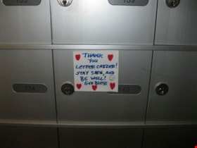
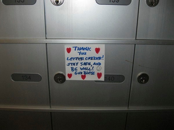
- Photograph of a handwritten sign taped to a postbox at 7072 Inlet Drive. The sign is decorated with hearts and a smiley face and reads "Thank you letter carrier! Stay safe, and be well! God bless".
- Repository
- City of Burnaby Archives
- Date
- April 29, 2020
- Collection/Fonds
- Burnaby Photographic Society fonds
- Physical Description
- 1 photograph (tiff)
- Description Level
- Item
- Record No.
- 623-050
- Access Restriction
- No restrictions
- Reproduction Restriction
- Reproduce for fair dealing purposes only
- Accession Number
- 2020-10
- Scope and Content
- Photograph of a handwritten sign taped to a postbox at 7072 Inlet Drive. The sign is decorated with hearts and a smiley face and reads "Thank you letter carrier! Stay safe, and be well! God bless".
- Media Type
- Photograph
- Photographer
- Lapierre, Soleil
- Notes
- Transcribed title
- Geographic Access
- Inlet Drive
- Street Address
- 7072 Inlet Drive
- Historic Neighbourhood
- Lochdale (Historic Neighbourhood)
- Planning Study Area
- Westridge Area
Images
![Prospective buyers at Strathmore development, [2004] thumbnail](/media/hpo/_Data/_Archives_Images/_Unrestricted/535/535-2369.jpg?width=280)
Prospective buyers at Strathmore development
https://search.heritageburnaby.ca/link/archivedescription96811
- Repository
- City of Burnaby Archives
- Date
- [2004]
- Collection/Fonds
- Burnaby NewsLeader photograph collection
- Description Level
- Item
- Physical Description
- 1 photograph (tiff) : col.
- Scope and Content
- Photograph of prospective buyers outside the sales centre for the Strathmore, a new townhouse and apartment development on Cameron Street across from Lougheed Town Centre. A crowd is gathering on the lawn and on chairs, and a sign advertising the development is in the foreground.
- Repository
- City of Burnaby Archives
- Date
- [2004]
- Collection/Fonds
- Burnaby NewsLeader photograph collection
- Physical Description
- 1 photograph (tiff) : col.
- Description Level
- Item
- Record No.
- 535-2369
- Access Restriction
- No restrictions
- Reproduction Restriction
- No restrictions
- Accession Number
- 2018-12
- Scope and Content
- Photograph of prospective buyers outside the sales centre for the Strathmore, a new townhouse and apartment development on Cameron Street across from Lougheed Town Centre. A crowd is gathering on the lawn and on chairs, and a sign advertising the development is in the foreground.
- Media Type
- Photograph
- Photographer
- Bartel, Mario
- Notes
- Title based on caption
- Collected by editorial for use in an April 2004 issue of the Burnaby NewsLeader
- Caption from metadata: "Prospective home buyers wait for their turn to enter the sales centre at the Strathmore, a new townhouse and apartment development to be built on Cameron St., across from Lougheed Town Centre. Anxious buyers in the red hot real estate market started lining up on Wednesday to get first crack at the new units."
- Geographic Access
- Cameron Street
- Historic Neighbourhood
- Burquitlam (Historic Neighbourhood)
- Planning Study Area
- Cameron Area
Images
![Prospective buyers at Strathmore development, [2004] thumbnail](/media/hpo/_Data/_Archives_Images/_Unrestricted/535/535-2369.jpg)
![Student with Edmonds Town Centre banner, [2002] thumbnail](/media/hpo/_Data/_Archives_Images/_Unrestricted/535/535-2915.jpg?width=280)
Student with Edmonds Town Centre banner
https://search.heritageburnaby.ca/link/archivedescription97599
- Repository
- City of Burnaby Archives
- Date
- [2002]
- Collection/Fonds
- Burnaby NewsLeader photograph collection
- Description Level
- Item
- Physical Description
- 1 photograph (tiff) : col.
- Scope and Content
- Photograph of Anthony Lazazzera, a grade three student at St. Francis de Sales School, posing with a banner he designed. The banner reads: "Edmonds Town Centre" and features a drawing of a sunflower.
- Repository
- City of Burnaby Archives
- Date
- [2002]
- Collection/Fonds
- Burnaby NewsLeader photograph collection
- Physical Description
- 1 photograph (tiff) : col.
- Description Level
- Item
- Record No.
- 535-2915
- Access Restriction
- No restrictions
- Reproduction Restriction
- No restrictions
- Accession Number
- 2018-12
- Scope and Content
- Photograph of Anthony Lazazzera, a grade three student at St. Francis de Sales School, posing with a banner he designed. The banner reads: "Edmonds Town Centre" and features a drawing of a sunflower.
- Media Type
- Photograph
- Photographer
- Bartel, Mario
- Notes
- Title based on caption
- Collected by editorial for use in a January 2002 issue of the Burnaby NewsLeader
- Caption from metadata: "Anthony Lazazzera, 8, a Grade Three student at St. Francis de Sales School, with the banner he designed that will hang from light standards in Burnaby's Edmonds area. Anthony says it took him "about 15 minutes" to come up with the design, which was inspired by a recent trip his family took to Italy. "We saw lots of sunflowers and we took lots of pictures of them," he says."
- Geographic Access
- Balmoral Street
- Historic Neighbourhood
- Edmonds (Historic Neighbourhood)
- Planning Study Area
- Kingsway-Beresford Area
- Edmonds Area
Images
![Student with Edmonds Town Centre banner, [2002] thumbnail](/media/hpo/_Data/_Archives_Images/_Unrestricted/535/535-2915.jpg)
![Road Sense sign, [2001] thumbnail](/media/hpo/_Data/_Archives_Images/_Unrestricted/535/535-2737.jpg?width=280)
Road Sense sign
https://search.heritageburnaby.ca/link/archivedescription97361
- Repository
- City of Burnaby Archives
- Date
- [2001]
- Collection/Fonds
- Burnaby NewsLeader photograph collection
- Description Level
- Item
- Physical Description
- 1 photograph (tiff) : col.
- Scope and Content
- Photograph of Leanne Cassap, of the ICBC Broker Road Sense Team, and Diane Mumford, the vice-chair of the Burnaby School District Parent Advisory Council, setting up a roadside sign by a school that reads: "30 km/h Monday-Friday 8 am - 5 pm."
- Repository
- City of Burnaby Archives
- Date
- [2001]
- Collection/Fonds
- Burnaby NewsLeader photograph collection
- Physical Description
- 1 photograph (tiff) : col.
- Description Level
- Item
- Record No.
- 535-2737
- Access Restriction
- No restrictions
- Reproduction Restriction
- No restrictions
- Accession Number
- 2018-12
- Scope and Content
- Photograph of Leanne Cassap, of the ICBC Broker Road Sense Team, and Diane Mumford, the vice-chair of the Burnaby School District Parent Advisory Council, setting up a roadside sign by a school that reads: "30 km/h Monday-Friday 8 am - 5 pm."
- Media Type
- Photograph
- Photographer
- Bartel, Mario
- Notes
- Title based on caption
- Collected by editorial for use in a September 2001 issue of the Burnaby NewsLeader
- Caption from metadata: "Leanne Cassap, of the ICBC Broker Road Sense Team, and Diane Mumford, the vice-chair of the Burnaby School District Parent Advisory Council, make sure drivers have plenty of notice to slow down around area schools."
Images
![Road Sense sign, [2001] thumbnail](/media/hpo/_Data/_Archives_Images/_Unrestricted/535/535-2737.jpg)
![Michelle Donders and Bullying Bites campaign, [2001] thumbnail](/media/hpo/_Data/_Archives_Images/_Unrestricted/535/535-2740.jpg?width=280)
Michelle Donders and Bullying Bites campaign
https://search.heritageburnaby.ca/link/archivedescription97364
- Repository
- City of Burnaby Archives
- Date
- [2001]
- Collection/Fonds
- Burnaby NewsLeader photograph collection
- Description Level
- Item
- Physical Description
- 1 photograph (tiff) : col.
- Scope and Content
- Photograph of Michelle Donders in the Lougheed Mall, signing an anti-bullying pledge board that reads: "Bullying Bites!"
- Repository
- City of Burnaby Archives
- Date
- [2001]
- Collection/Fonds
- Burnaby NewsLeader photograph collection
- Physical Description
- 1 photograph (tiff) : col.
- Description Level
- Item
- Record No.
- 535-2740
- Access Restriction
- No restrictions
- Reproduction Restriction
- No restrictions
- Accession Number
- 2018-12
- Scope and Content
- Photograph of Michelle Donders in the Lougheed Mall, signing an anti-bullying pledge board that reads: "Bullying Bites!"
- Names
- Lougheed Town Centre
- Media Type
- Photograph
- Photographer
- Bartel, Mario
- Notes
- Title based on caption
- Collected by editorial for use in a September 2001 issue of the Burnaby NewsLeader
- Caption from metadata: "Michelle Donders signs an anti-bullying pledge board at the Lougheed Mall. The board was part of a community awareness campaign to help stop bullying. Similar boards from around the area will eventually be displayed at Parliament Hill, in an effort to get federal politicians to declare a national anti-bullying day."
- Geographic Access
- Austin Road
- Street Address
- 9855 Austin Avenue
- Historic Neighbourhood
- Burquitlam (Historic Neighbourhood)
- Planning Study Area
- Cameron Area
Images
![Michelle Donders and Bullying Bites campaign, [2001] thumbnail](/media/hpo/_Data/_Archives_Images/_Unrestricted/535/535-2740.jpg)
![Maywood Community School students with banners, [2000] thumbnail](/media/hpo/_Data/_Archives_Images/_Unrestricted/535/535-2119.jpg?width=280)
Maywood Community School students with banners
https://search.heritageburnaby.ca/link/archivedescription96495
- Repository
- City of Burnaby Archives
- Date
- [2000]
- Collection/Fonds
- Burnaby NewsLeader photograph collection
- Description Level
- Item
- Physical Description
- 1 photograph (tiff) : col.
- Scope and Content
- Photograph of Maywood Community School students Saulina Wong and Wendy Yang posing with next to a streetlight that features banners painted by Maywood students, in the neighbourhood around Bonsor Recreation Centre.
- Repository
- City of Burnaby Archives
- Date
- [2000]
- Collection/Fonds
- Burnaby NewsLeader photograph collection
- Physical Description
- 1 photograph (tiff) : col.
- Description Level
- Item
- Record No.
- 535-2119
- Access Restriction
- No restrictions
- Reproduction Restriction
- No restrictions
- Accession Number
- 2018-12
- Scope and Content
- Photograph of Maywood Community School students Saulina Wong and Wendy Yang posing with next to a streetlight that features banners painted by Maywood students, in the neighbourhood around Bonsor Recreation Centre.
- Media Type
- Photograph
- Photographer
- Bartel, Mario
- Notes
- Title based on caption
- Collected by editorial for use in a March 2000 issue of the Burnaby NewsLeader
- Caption from metadata: "Saulina Wong, 12, and Wendy Yang, 11, show their approval for the new banners, painted by students at Maywood Community School, that will be hung from light standards around Bonsor Recreation Centre."
- Historic Neighbourhood
- Central Park (Historic Neighbourhood)
- Planning Study Area
- Marlborough Area
Images
![Maywood Community School students with banners, [2000] thumbnail](/media/hpo/_Data/_Archives_Images/_Unrestricted/535/535-2119.jpg)
![Ancient Willow Bed & Breakfast sign, [2000] thumbnail](/media/hpo/_Data/_Archives_Images/_Unrestricted/535/535-2137.jpg?width=280)
Ancient Willow Bed & Breakfast sign
https://search.heritageburnaby.ca/link/archivedescription96513
- Repository
- City of Burnaby Archives
- Date
- [2000]
- Collection/Fonds
- Burnaby NewsLeader photograph collection
- Description Level
- Item
- Physical Description
- 1 photograph (tiff) : col.
- Scope and Content
- Photograph of Leah-Anne Arbers posing in front of her bed and breakfast, Ancient Willow, with a sign that was broken by vandals. Arbers' cousin Olga Shevchenko stands behind her, holding part of the broken sign, which reads: "BED."
- Repository
- City of Burnaby Archives
- Date
- [2000]
- Collection/Fonds
- Burnaby NewsLeader photograph collection
- Physical Description
- 1 photograph (tiff) : col.
- Description Level
- Item
- Record No.
- 535-2137
- Access Restriction
- No restrictions
- Reproduction Restriction
- No restrictions
- Accession Number
- 2018-12
- Scope and Content
- Photograph of Leah-Anne Arbers posing in front of her bed and breakfast, Ancient Willow, with a sign that was broken by vandals. Arbers' cousin Olga Shevchenko stands behind her, holding part of the broken sign, which reads: "BED."
- Subjects
- Buildings - Commercial - Hotels and Motels
- Advertising Medium - Signs and Signboards
- Crimes
- Media Type
- Photograph
- Photographer
- Bartel, Mario
- Notes
- Title based on caption
- Collected by editorial for use in an April 2000 issue of the Burnaby NewsLeader
- Caption from metadata: "Leah-Anne Arbers, and her cousin, Olga Shevchenko, who helps her run her Parker St. bed and breakfast, with pieces of the sign destroyed by teenage vandals."
- Geographic Access
- Parker Street
- Planning Study Area
- Willingdon Heights Area
- Brentwood Area
Images
![Ancient Willow Bed & Breakfast sign, [2000] thumbnail](/media/hpo/_Data/_Archives_Images/_Unrestricted/535/535-2137.jpg)
![Caila Anderson with traffic signs, [2000] thumbnail](/media/hpo/_Data/_Archives_Images/_Unrestricted/535/535-2547.jpg?width=280)
Caila Anderson with traffic signs
https://search.heritageburnaby.ca/link/archivedescription97015
- Repository
- City of Burnaby Archives
- Date
- [2000]
- Collection/Fonds
- Burnaby NewsLeader photograph collection
- Description Level
- Item
- Physical Description
- 1 photograph (tiff) : col.
- Scope and Content
- Photograph of Caila Anderson, an employee of International SPFX, standing with her arms crossed next to two traffic signs on Greenwood Street.
- Repository
- City of Burnaby Archives
- Date
- [2000]
- Collection/Fonds
- Burnaby NewsLeader photograph collection
- Physical Description
- 1 photograph (tiff) : col.
- Description Level
- Item
- Record No.
- 535-2547
- Access Restriction
- No restrictions
- Reproduction Restriction
- No restrictions
- Accession Number
- 2018-12
- Scope and Content
- Photograph of Caila Anderson, an employee of International SPFX, standing with her arms crossed next to two traffic signs on Greenwood Street.
- Subjects
- Planning - City Planning
- Advertising Medium - Signs and Signboards
- Geographic Features - Roads
- Media Type
- Photograph
- Photographer
- Bartel, Mario
- Notes
- Title based on caption
- Collected by editorial for use in a July 2000 issue of the Burnaby NewsLeader
- Caption from metadata: "Caila Anderson, of International SPFX, says new traffic regulations on Greenwood St. have made it really inconvenient for employees at the movie special effects company to get to and from their production offices. Residents on the street say the regulations haven't gone far enough."
- Geographic Access
- Greenwood Street
- Historic Neighbourhood
- Lozells (Historic Neighbourhood)
- Planning Study Area
- Government Road Area
Images
![Caila Anderson with traffic signs, [2000] thumbnail](/media/hpo/_Data/_Archives_Images/_Unrestricted/535/535-2547.jpg)
![Condominiums, [2000] thumbnail](/media/hpo/_Data/_Archives_Images/_Unrestricted/535/535-2869-1.jpg?width=280)
Condominiums
https://search.heritageburnaby.ca/link/archivedescription97530
- Repository
- City of Burnaby Archives
- Date
- [2000]
- Collection/Fonds
- Burnaby NewsLeader photograph collection
- Description Level
- File
- Physical Description
- 2 photographs (tiff) : col.
- Scope and Content
- File contains photographs of two condominium buildings. One building has a sign that reads: "Final Sell Out," and towers are visible behind the complex in the other photograph.
- Repository
- City of Burnaby Archives
- Date
- [2000]
- Collection/Fonds
- Burnaby NewsLeader photograph collection
- Physical Description
- 2 photographs (tiff) : col.
- Description Level
- File
- Record No.
- 535-2869
- Access Restriction
- No restrictions
- Reproduction Restriction
- No restrictions
- Accession Number
- 2018-12
- Scope and Content
- File contains photographs of two condominium buildings. One building has a sign that reads: "Final Sell Out," and towers are visible behind the complex in the other photograph.
- Subjects
- Buildings - Residential - Condominiums
- Buildings - Residential
- Advertising Medium - Signs and Signboards
- Media Type
- Photograph
- Notes
- Title based on contents of file
- Collected by editorial for use in an October 2000 issue of the Burnaby NewsLeader
Images
![Condominiums, [2000] thumbnail](/media/hpo/_Data/_Archives_Images/_Unrestricted/535/535-2869-1.jpg)
![Dismantling the Eaton Centre sign, [2000] thumbnail](/media/hpo/_Data/_Archives_Images/_Unrestricted/535/535-2901.jpg?width=280)
Dismantling the Eaton Centre sign
https://search.heritageburnaby.ca/link/archivedescription97562
- Repository
- City of Burnaby Archives
- Date
- [2000]
- Collection/Fonds
- Burnaby NewsLeader photograph collection
- Description Level
- Item
- Physical Description
- 1 photograph (tiff) : col.
- Scope and Content
- Photograph of a construction worker dismantling the Eaton Centre sign at the new Metropolis at Metrotown mall.
- Repository
- City of Burnaby Archives
- Date
- [2000]
- Collection/Fonds
- Burnaby NewsLeader photograph collection
- Physical Description
- 1 photograph (tiff) : col.
- Description Level
- Item
- Record No.
- 535-2901
- Access Restriction
- No restrictions
- Reproduction Restriction
- No restrictions
- Accession Number
- 2018-12
- Scope and Content
- Photograph of a construction worker dismantling the Eaton Centre sign at the new Metropolis at Metrotown mall.
- Names
- Metrotown
- Media Type
- Photograph
- Photographer
- Bartel, Mario
- Notes
- Title based on caption
- Collected by editorial for use in an October 2000 issue of the Burnaby NewsLeader
- Caption from metadata: "Workers dismantle the Eaton Centre sign as the mall at Metrotown begins its new life as Metropolis at Metrotown."
- Geographic Access
- Kingsway
- Street Address
- 4700 Kingsway
- Historic Neighbourhood
- Central Park (Historic Neighbourhood)
- Planning Study Area
- Maywood Area
Images
![Dismantling the Eaton Centre sign, [2000] thumbnail](/media/hpo/_Data/_Archives_Images/_Unrestricted/535/535-2901.jpg)
![Robert Nasato at Marine/10th Ave. Connector, [2000] thumbnail](/media/hpo/_Data/_Archives_Images/_Unrestricted/535/535-3069.jpg?width=280)
Robert Nasato at Marine/10th Ave. Connector
https://search.heritageburnaby.ca/link/archivedescription97943
- Repository
- City of Burnaby Archives
- Date
- [2000]
- Collection/Fonds
- Burnaby NewsLeader photograph collection
- Description Level
- Item
- Physical Description
- 1 photograph (tiff) : col.
- Scope and Content
- Photograph of Robert Nasato, the president of the West End Residents' Association, posing net to sign advertising the plans for the Marine/10th Ave. Connector.
- Repository
- City of Burnaby Archives
- Date
- [2000]
- Collection/Fonds
- Burnaby NewsLeader photograph collection
- Physical Description
- 1 photograph (tiff) : col.
- Description Level
- Item
- Record No.
- 535-3069
- Access Restriction
- No restrictions
- Reproduction Restriction
- No restrictions
- Accession Number
- 2018-12
- Scope and Content
- Photograph of Robert Nasato, the president of the West End Residents' Association, posing net to sign advertising the plans for the Marine/10th Ave. Connector.
- Media Type
- Photograph
- Photographer
- Bartel, Mario
- Notes
- Title based on caption
- Collected by editorial for use in a January 2000 issue of the Burnaby NewsLeader
- Caption from metadata: "Robert Nasato, the president of the West End Residents' Association, isn't happy about the proposed Marine/10th Ave. connector, to be built through his neighborhood."
- Geographic Access
- 10th Avenue
- Marine Drive
- Historic Neighbourhood
- Fraser Arm (Historic Neighbourhood)
- Planning Study Area
- Stride Hill Area
Images
![Robert Nasato at Marine/10th Ave. Connector, [2000] thumbnail](/media/hpo/_Data/_Archives_Images/_Unrestricted/535/535-3069.jpg)
![Second Street School banners, [1999] thumbnail](/media/hpo/_Data/_Archives_Images/_Unrestricted/535/535-3247.jpg?width=280)
Second Street School banners
https://search.heritageburnaby.ca/link/archivedescription98169
- Repository
- City of Burnaby Archives
- Date
- [1999]
- Collection/Fonds
- Burnaby NewsLeader photograph collection
- Description Level
- Item
- Physical Description
- 1 photograph (tiff) : col.
- Scope and Content
- Photograph of an Brian Sarginson, of the City of Burnaby Engineering Department, installing banners depicting birds and a growing garden on a streetlight by Second Street School. The banners were painted by students and local artist Joanne Folks.
- Repository
- City of Burnaby Archives
- Date
- [1999]
- Collection/Fonds
- Burnaby NewsLeader photograph collection
- Physical Description
- 1 photograph (tiff) : col.
- Description Level
- Item
- Record No.
- 535-3247
- Access Restriction
- No restrictions
- Reproduction Restriction
- No restrictions
- Accession Number
- 2018-12
- Scope and Content
- Photograph of an Brian Sarginson, of the City of Burnaby Engineering Department, installing banners depicting birds and a growing garden on a streetlight by Second Street School. The banners were painted by students and local artist Joanne Folks.
- Names
- Second Street School
- Media Type
- Photograph
- Photographer
- Bartel, Mario
- Notes
- Title based on caption
- Collected by editorial for use in a July 1999 issue of the Burnaby NewsLeader
- Caption from metadata: "Brian Sarginson, of Burnaby's Engineering Department, hangs some of the eight banners designed and painted by students at Second Ave. Community School, with a little guidance from local artist, Joanne Folks."
- Geographic Access
- 2nd Street
- Street Address
- 7502 2nd Street
- Historic Neighbourhood
- East Burnaby (Historic Neighbourhood)
- Planning Study Area
- Second Street Area
Images
![Second Street School banners, [1999] thumbnail](/media/hpo/_Data/_Archives_Images/_Unrestricted/535/535-3247.jpg)

Deer Lake
https://search.heritageburnaby.ca/link/archivedescription91707
- Repository
- City of Burnaby Archives
- Date
- 1994-1996
- Collection/Fonds
- Doreen Lawson fonds
- Description Level
- File
- Physical Description
- 55 photographs : col. slides ; 35 mm
- Scope and Content
- File consists of scenic photographs of Deer Lake and Deer Lake Park, including closeup photographs of the lake and landscape photographs with the lake in the foreground and mountains and skyline visible in the distance. The photographs capture Deer Lake in the fall, winter, and spring. Also inclu…
- Repository
- City of Burnaby Archives
- Date
- 1994-1996
- Collection/Fonds
- Doreen Lawson fonds
- Physical Description
- 55 photographs : col. slides ; 35 mm
- Description Level
- File
- Record No.
- 618-025
- Access Restriction
- No restrictions
- Reproduction Restriction
- No restrictions
- Accession Number
- 2015-15
- Scope and Content
- File consists of scenic photographs of Deer Lake and Deer Lake Park, including closeup photographs of the lake and landscape photographs with the lake in the foreground and mountains and skyline visible in the distance. The photographs capture Deer Lake in the fall, winter, and spring. Also included in the file are four photographs of Deer Lake Park signs.
- Subjects
- Natural Phenomena - Snow
- Geographic Features - Lakes and Ponds
- Plants - Trees
- Geographic Features - Mountains
- Advertising Medium - Signs and Signboards
- Names
- Burnaby Art Gallery
- Media Type
- Photograph
- Photographer
- Lawson, Doreen A.
- Notes
- Title based on contents of photographs
- Geographic Access
- Deer Lake
- Historic Neighbourhood
- Burnaby Lake (Historic Neighbourhood)
- Planning Study Area
- Oakalla Area
Images


Lillian Mann's property
https://search.heritageburnaby.ca/link/archivedescription46242
- Repository
- City of Burnaby Archives
- Date
- March 1983
- Collection/Fonds
- Columbian Newspaper collection
- Description Level
- Item
- Physical Description
- 1 photograph : b&w ; 15.5 x 23.5 cm
- Scope and Content
- Photograph of Lillian Mann's property, with signs which read such things as; "Forced Sale", "Expropriation Sale!" and Demolition Sale!" posted up along the front yard, and nailed to the large Cedar tree.
- Repository
- City of Burnaby Archives
- Date
- March 1983
- Collection/Fonds
- Columbian Newspaper collection
- Physical Description
- 1 photograph : b&w ; 15.5 x 23.5 cm
- Description Level
- Item
- Record No.
- 480-1130
- Access Restriction
- No restrictions
- Reproduction Restriction
- No restrictions
- Accession Number
- 2003-02
- Scope and Content
- Photograph of Lillian Mann's property, with signs which read such things as; "Forced Sale", "Expropriation Sale!" and Demolition Sale!" posted up along the front yard, and nailed to the large Cedar tree.
- Media Type
- Photograph
- Photographer
- King, Basil
- Notes
- Title based on contents of photograph
- Newspaper clipping attached to verso of photograph reads: "READY TO MOVE ... Lillian Mann, the Burnaby homeowner who waged a lengthy but unsuccessful battle against expropriation of her Cameron Street home, is ready to move. But she hasn't lost her spark, as the terse messages on her front lawn indicate. The property is to become a parking lot for the Cameron Public Library."
- Geographic Access
- Cameron Street
- Historic Neighbourhood
- Burquitlam (Historic Neighbourhood)
- Planning Study Area
- Lyndhurst Area
Images


Grocery store
https://search.heritageburnaby.ca/link/archivedescription52859
- Repository
- City of Burnaby Archives
- Date
- 1983
- Collection/Fonds
- Harold H. Johnston fonds
- Description Level
- Item
- Physical Description
- 1 photograph (jpeg) : b&w
- Scope and Content
- Photograph of an unidentified grocery store.
- Repository
- City of Burnaby Archives
- Date
- 1983
- Collection/Fonds
- Harold H. Johnston fonds
- Physical Description
- 1 photograph (jpeg) : b&w
- Description Level
- Item
- Record No.
- 483-103
- Access Restriction
- No restrictions
- Reproduction Restriction
- No reproduction permitted
- Accession Number
- 2008-08
- Scope and Content
- Photograph of an unidentified grocery store.
- Media Type
- Photograph
- Photographer
- Johnston, Harold H.
- Notes
- Title based on contents of photograph
Images


123 Cinema sign
https://search.heritageburnaby.ca/link/archivedescription46283
- Repository
- City of Burnaby Archives
- Date
- November 15, 1979
- Collection/Fonds
- Columbian Newspaper collection
- Description Level
- Item
- Physical Description
- 1 photograph : b&w ; 24 x 9.5 cm
- Scope and Content
- Photograph of the 123 Cinema sign at Lougheed Mall which reads; "VOTE NOV 17 / DAVE MERCIER BVA / MAYOR".
- Repository
- City of Burnaby Archives
- Date
- November 15, 1979
- Collection/Fonds
- Columbian Newspaper collection
- Physical Description
- 1 photograph : b&w ; 24 x 9.5 cm
- Description Level
- Item
- Record No.
- 480-1171
- Access Restriction
- No restrictions
- Reproduction Restriction
- Reproduce for fair dealing purposes only
- Accession Number
- 2003-02
- Scope and Content
- Photograph of the 123 Cinema sign at Lougheed Mall which reads; "VOTE NOV 17 / DAVE MERCIER BVA / MAYOR".
- Names
- Lougheed Town Centre
- Media Type
- Photograph
- Photographer
- Hodge, Craig
- Notes
- Title based on contents of photograph
- Newspaper clipping attached to verso of photograph reads: "Now showing: Strong support for Mercier."
- Geographic Access
- Austin Road
- Historic Neighbourhood
- Burquitlam (Historic Neighbourhood)
- Planning Study Area
- Cameron Area
Images


Crossing Royal Oak & Rumble Street
https://search.heritageburnaby.ca/link/archivedescription93686
- Repository
- City of Burnaby Archives
- Date
- May 19, 1978
- Collection/Fonds
- Burnaby Public Library Contemporary Visual Archive Project
- Description Level
- Item
- Physical Description
- 1 photograph : b&w ; 12.5 x 17.5 cm
- Scope and Content
- Photograph of the intersection of Royal Oak Avenue and Rumble Street. Cars and pedestrians are crossing the intersection, and the signs for businesses TD Bank, Standard Oil/Chevron gas station, Gulf gas station, and Baxter's Market are visible. The photograph is taken from a corner of the intersect…
- Repository
- City of Burnaby Archives
- Date
- May 19, 1978
- Collection/Fonds
- Burnaby Public Library Contemporary Visual Archive Project
- Physical Description
- 1 photograph : b&w ; 12.5 x 17.5 cm
- Description Level
- Item
- Record No.
- 556-643
- Access Restriction
- No restrictions
- Reproduction Restriction
- Reproduce for fair dealing purposes only
- Accession Number
- 2017-57
- Scope and Content
- Photograph of the intersection of Royal Oak Avenue and Rumble Street. Cars and pedestrians are crossing the intersection, and the signs for businesses TD Bank, Standard Oil/Chevron gas station, Gulf gas station, and Baxter's Market are visible. The photograph is taken from a corner of the intersection, facing southeast.
- Subjects
- Geographic Features - Roads
- Advertising Medium - Signs and Signboards
- Buildings - Commercial - Service Stations
- Transportation - Automobiles
- Buildings - Commercial
- Media Type
- Photograph
- Photographer
- van Mannen, Mark
- Notes
- Title taken from project information form
- Accompanied by a project information form and 1 photograph (b&w negative ; 9.5 x 12.5 cm)
- BPL no. 91
- Geographic Access
- Royal Oak Avenue
- Rumble Street
- Historic Neighbourhood
- Alta Vista (Historic Neighbourhood)
- Planning Study Area
- Sussex-Nelson Area
Images


Crossing Royal Oak & Rumble Street
https://search.heritageburnaby.ca/link/archivedescription93687
- Repository
- City of Burnaby Archives
- Date
- May 19, 1978
- Collection/Fonds
- Burnaby Public Library Contemporary Visual Archive Project
- Description Level
- Item
- Physical Description
- 1 photograph : b&w ; 12.5 x 17.5 cm
- Scope and Content
- Photograph of the intersection of Royal Oak Avenue and Rumble Street. Cars and pedestrians are crossing the intersection, and the signs for businesses Grace United Pharmacy, Standard Oil/Chevron gas station, Gulf gas station, and Royal Meats are visible. The photograph is taken from the Gulf gas st…
- Repository
- City of Burnaby Archives
- Date
- May 19, 1978
- Collection/Fonds
- Burnaby Public Library Contemporary Visual Archive Project
- Physical Description
- 1 photograph : b&w ; 12.5 x 17.5 cm
- Description Level
- Item
- Record No.
- 556-644
- Access Restriction
- No restrictions
- Reproduction Restriction
- Reproduce for fair dealing purposes only
- Accession Number
- 2017-57
- Scope and Content
- Photograph of the intersection of Royal Oak Avenue and Rumble Street. Cars and pedestrians are crossing the intersection, and the signs for businesses Grace United Pharmacy, Standard Oil/Chevron gas station, Gulf gas station, and Royal Meats are visible. The photograph is taken from the Gulf gas station parking lot, facing northwest.
- Subjects
- Advertising Medium - Signs and Signboards
- Geographic Features - Roads
- Transportation - Automobiles
- Buildings - Commercial
- Buildings - Commercial - Service Stations
- Media Type
- Photograph
- Photographer
- van Mannen, Mark
- Notes
- Title taken from project information form
- Accompanied by a project information form and 1 photograph (b&w negative ; 9.5 x 12.5 cm)
- BPL no. 92
- Geographic Access
- Royal Oak Avenue
- Rumble Street
- Historic Neighbourhood
- Alta Vista (Historic Neighbourhood)
- Planning Study Area
- Sussex-Nelson Area
Images
