Narrow Results By
Subject
- Adornment 83
- Adornment - Jewelry 4
- Adornment - Lapel Pins 83
- Advertising Medium 92
- Advertising Medium - Business Cards 17
- Advertising Medium - Flyer 34
- Advertising Medium - Poster 2
- Advertising Medium - Signs and Signboards 36
- Agricultural Tools and Equipment 5
- Agricultural Tools and Equipment - Cultivators 1
- Agricultural Tools and Equipment - Gardening Equipment 2
- Agriculture 3
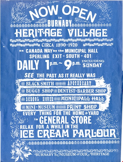
![Map of proposed provincial exhibition site at Burnaby Lake, [between 1929 and 1931] thumbnail](/media/hpo/_Data/_BVM_Cartographic_Material/2017/2017_0002_0009_005.jpg?width=280)
Map of proposed provincial exhibition site at Burnaby Lake
https://search.heritageburnaby.ca/link/museumdescription8703
- Repository
- Burnaby Village Museum
- Date
- [between 1929 and 1931]
- Collection/Fonds
- Burnaby Village Museum Map collection
- Description Level
- Item
- Physical Description
- 1 map : photostat print ; 3 parts 45 x 33.7 cm totalling 45 x 101 cm
- Scope and Content
- Item consists of a tri-part folding map of a proposed Provincial Exhibition site located along the southern and western shore of Burnaby Lake. Exhibtion site on map identifies proposed locations for a golf course, pier, hydroplane landing ramp, sports ground, one-mile horse racing track and various…
- Repository
- Burnaby Village Museum
- Collection/Fonds
- Burnaby Village Museum Map collection
- Description Level
- Item
- Physical Description
- 1 map : photostat print ; 3 parts 45 x 33.7 cm totalling 45 x 101 cm
- Material Details
- Scale [1:1800]
- Scope and Content
- Item consists of a tri-part folding map of a proposed Provincial Exhibition site located along the southern and western shore of Burnaby Lake. Exhibtion site on map identifies proposed locations for a golf course, pier, hydroplane landing ramp, sports ground, one-mile horse racing track and various buildings for mechanical, agricultural and botanical displays.
- Subjects
- Exhibitions
- Accession Code
- BV017.2.9
- Access Restriction
- No restrictions
- Reproduction Restriction
- No known restrictions
- Date
- [between 1929 and 1931]
- Media Type
- Cartographic Material
- Historic Neighbourhood
- Burnaby Lake (Historic Neighbourhood)
- Planning Study Area
- Burnaby Lake Area
- Scan Resolution
- 400
- Scan Date
- 2021-11-18
- Notes
- Title based on contents of map
- Scale on map reads: "150 feet to 1 inch"
- Overall measurements when fully opened: L: 98.0 cm x H: 45.3 cm ; Individual map parts: L: 32.7 cm x H: 45.0 cm
- Commercially printed label on front of portfolio card reads "PLOWRIGHT PRINTING COMPANY / TELEPHONE N.W. 1942 / 39 McKENZIE STREET NEW WESTMINSTER, B.C. / TO: [illegible writing in pencil]" in blue ink. Red typewritten text reads: "PHOTOSTAT OF BURNABY LAKE".
Images
![Map of proposed provincial exhibition site at Burnaby Lake, [between 1929 and 1931] thumbnail](/media/hpo/_Data/_BVM_Cartographic_Material/2017/2017_0002_0009_005.jpg)


poster
https://search.heritageburnaby.ca/link/museumartifact90081
- Repository
- Burnaby Village Museum
- Accession Code
- HV976.232.27
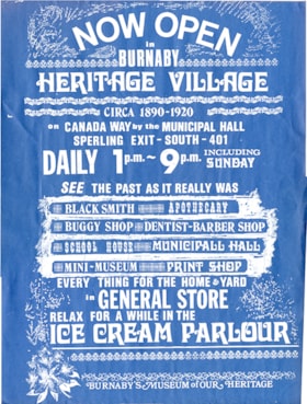
- Description
- poster; rectangular, blue cardstock; text in white reads: "NOW OPEN / IN / BURNABY / HERITAGE VILLAGE / CIRCA 1890-1920 / on CANADA WAY by the MUNICIPAL HALL / SPERLING EXIT - SOUTH - 401 / DAILY 1 p.m. - 9 p.m. INCLUDING SUNDAY / SEE THE PAST AS IT REALLY WAS / BLACKSMITH_APOTHECARY / BUGGY SHOP_DENTIST-BARBER SHOP / SCHOOL HOUSE_ MUNICIPAL HALL / MINI MUSEUM_PRINT SHOP / EVERY THING FOR THE HOME & YARD / in GENERAL STORE / RELAX FOR A WHILE IN THE / ICE CREAM PARLOUR/ BURNABY'S MUSEUM OF OUR HERITAGE"; includes border art horizontally dispersed between text; image of rhododendron in bottom left corner. printed in Heritage Village print shop. [ca.1971-1975]
- Object History
- Object belonged to Mary D. Trainer, as a member of the Burnaby Centennial '71 Committee and the Centennial Co-ordinator hired to help organize a variety of community events to commemorate the 100th anniversary of British Columbia's entry into Confederation.
- Category
- 08. Communication Artifacts
- Classification
- Advertising Media
- Object Term
- Poster
- Colour
- Blue
- White
- Measurements
- Length: 44.0 cm x Width: 33.2 cm
- Maker
- Heritage Village
- Country Made
- Canada
- Province Made
- British Columbia
- Site/City Made
- Burnaby
Images