Narrow Results By
Subject
- Academic Disciplines 3
- Accidents 14
- Accidents - Automobile Accidents 31
- Accidents - Train Accidents 23
- Adminstrative Groups - Committees 4
- Adornment
- Adornment - Jewelry 11
- Adornment - Lapel Pins 84
- Advertising Medium 104
- Advertising Medium - Business Cards 17
- Advertising Medium - Flyer 38
- Advertising Medium - Poster 18
Creator
- Aero Surveys Limited 2
- Campbell, Peg 6
- Campbell Studios Limited 1
- Commercial Illustrators Industrial Photographers 3
- Cook, Alan 4
- Cunningham, W. 2
- Gardiner, Robert 1
- George Allen Aerial Photos Limited 2
- Graphic Industries Limited 2
- Hildred, Chris 1
- Hodge, Craig 3
- Hunting Survey Corporation Limited 2
![City of Bacharach, Germany, [1880] thumbnail](/media/hpo/_Data/_Archives_Images/_Unrestricted/477/477-801.jpg?width=280)
City of Bacharach, Germany
https://search.heritageburnaby.ca/link/archivedescription39482
- Repository
- City of Burnaby Archives
- Date
- [1880]
- Collection/Fonds
- Peers Family and Hill Family fonds
- Description Level
- Item
- Physical Description
- 1 photograph : sepia ; 10 x 15 cm on page 21.5 x 28 cm (pasted in album)
- Scope and Content
- Photograph of the city of Bacharach in Germany, boardering the river. This photograph was in a scrapbook kept by Claude Hill who was originally from England but ultimately settled in the Burnaby Lake area.
- Repository
- City of Burnaby Archives
- Date
- [1880]
- Collection/Fonds
- Peers Family and Hill Family fonds
- Physical Description
- 1 photograph : sepia ; 10 x 15 cm on page 21.5 x 28 cm (pasted in album)
- Description Level
- Item
- Record No.
- 477-801
- Access Restriction
- No restrictions
- Reproduction Restriction
- No known restrictions
- Accession Number
- 2007-12
- Scope and Content
- Photograph of the city of Bacharach in Germany, boardering the river. This photograph was in a scrapbook kept by Claude Hill who was originally from England but ultimately settled in the Burnaby Lake area.
- Media Type
- Photograph
- Notes
- Title based on contents of photograph
Images
![City of Bacharach, Germany, [1880] thumbnail](/media/hpo/_Data/_Archives_Images/_Unrestricted/477/477-801.jpg)
![City of Mainz, Germany, [1880] thumbnail](/media/hpo/_Data/_Archives_Images/_Unrestricted/477/477-798.jpg?width=280)
City of Mainz, Germany
https://search.heritageburnaby.ca/link/archivedescription39479
- Repository
- City of Burnaby Archives
- Date
- [1880]
- Collection/Fonds
- Peers Family and Hill Family fonds
- Description Level
- Item
- Physical Description
- 1 photograph : b&w ; 10 x 15 cm on page 21.5 x 28 cm (pasted in album)
- Scope and Content
- Photograph of the City of Mainz in Germany. This item was in a scrapbook kept by Claude Hill who was originally from England but ultimately settled in the Burnaby Lake area.
- Repository
- City of Burnaby Archives
- Date
- [1880]
- Collection/Fonds
- Peers Family and Hill Family fonds
- Physical Description
- 1 photograph : b&w ; 10 x 15 cm on page 21.5 x 28 cm (pasted in album)
- Description Level
- Item
- Record No.
- 477-798
- Access Restriction
- No restrictions
- Reproduction Restriction
- No known restrictions
- Accession Number
- 2007-12
- Scope and Content
- Photograph of the City of Mainz in Germany. This item was in a scrapbook kept by Claude Hill who was originally from England but ultimately settled in the Burnaby Lake area.
- Media Type
- Photograph
- Notes
- Title based on contents of photograph
Images
![City of Mainz, Germany, [1880] thumbnail](/media/hpo/_Data/_Archives_Images/_Unrestricted/477/477-798.jpg)
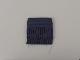
cockade
https://search.heritageburnaby.ca/link/museumartifact87605
- Repository
- Burnaby Village Museum
- Accession Code
- BV015.35.146
- Description
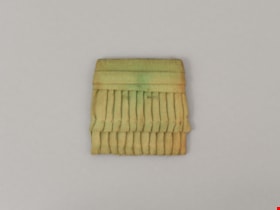
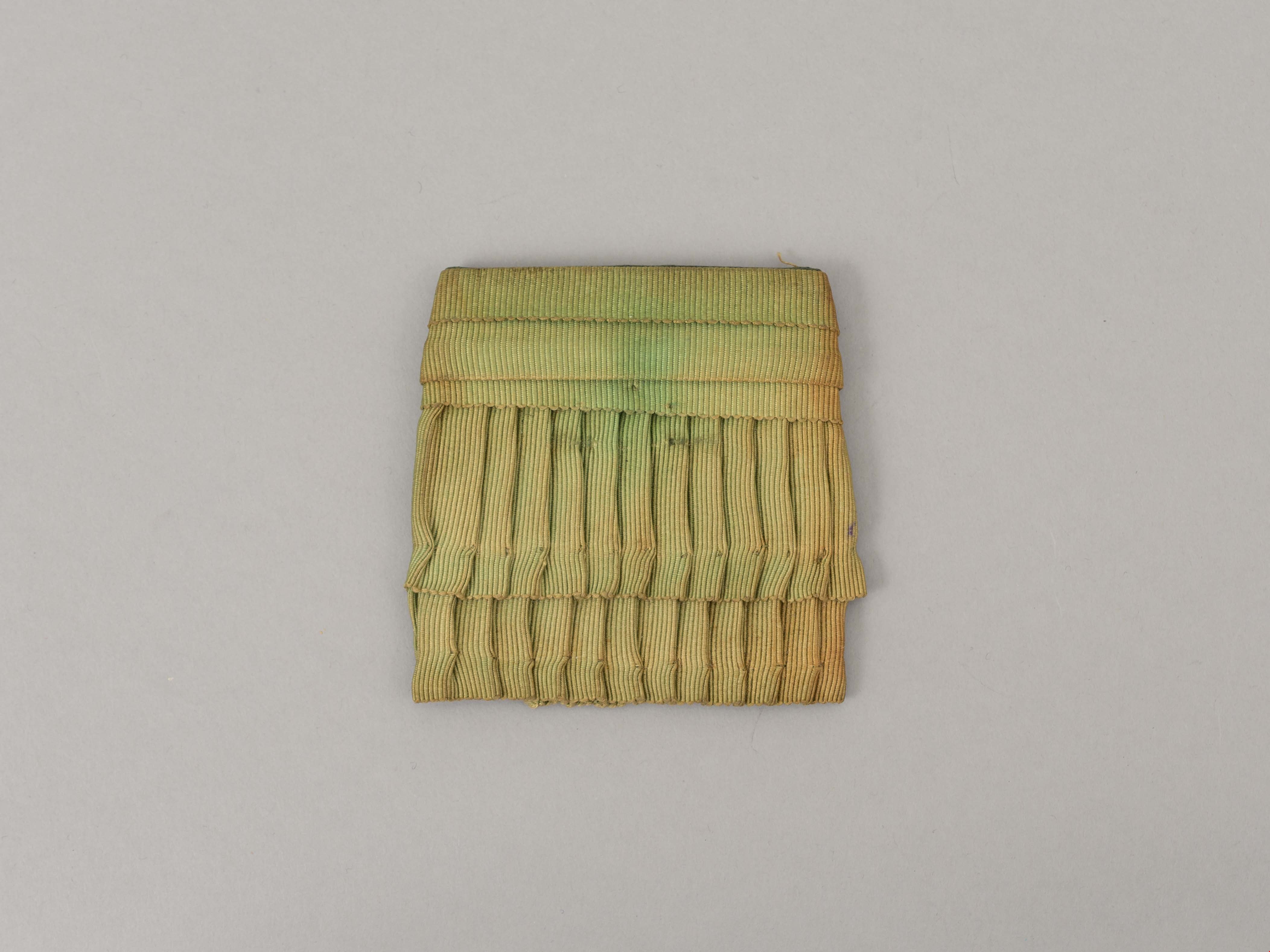
- cockade, Girl Guides and Rangers; navy blue grosgrain ribbon cockade; indicates position of Captain; worn on hat; in use 1919-1948
- Reference
- http://www.girlguides.ca/WEB/Documents/ON/Archives/Insignia_Commissioners.pdf
- Category
- 03. Personal Artifacts
- Classification
- Adornment
- Personal Symbols
- Personal Symbols - - Personal Identification
- Personal Symbols - - Status Symbols
- Subjects
- Adornment
- Personal Symbols - Ribbons
- Organizations
- Organizations - Girls' Societies and Clubs
- Names
- Girl Guides of Canada
Images
cockade
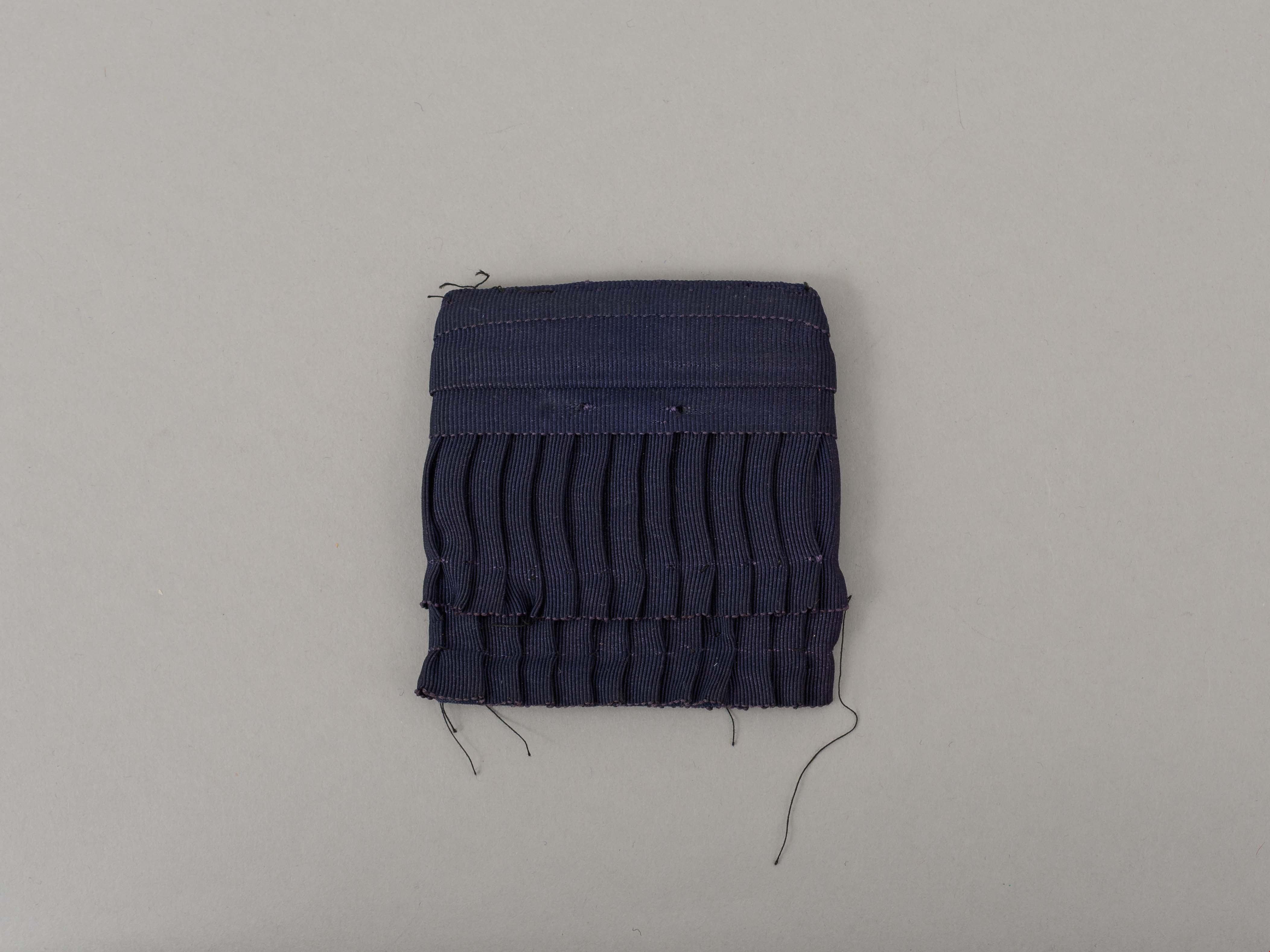
https://search.heritageburnaby.ca/link/museumartifact87606
- Repository
- Burnaby Village Museum
- Accession Code
- BV015.35.147
- Description
- cockade, Girl Guides and Rangers; navy blue grosgrain ribbon cockade; indicates position of Captain; worn on hat; in use 1919-1948
- Reference
- http://www.girlguides.ca/WEB/Documents/ON/Archives/Insignia_Commissioners.pdf
- Category
- 03. Personal Artifacts
- Classification
- Adornment
- Personal Symbols
- Personal Symbols - - Personal Identification
- Personal Symbols - - Status Symbols
- Subjects
- Adornment
- Personal Symbols - Ribbons
- Organizations
- Organizations - Girls' Societies and Clubs
- Names
- Girl Guides of Canada
Images
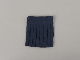
cockade
https://search.heritageburnaby.ca/link/museumartifact87607
- Repository
- Burnaby Village Museum
- Accession Code
- BV015.35.148
- Description
- cockade, Girl Guides; green grosgrain ribbon cockade; indicates position of Cadet Captain (District Guider); worn on hat; in use 1941-1948
- Reference
- http://www.girlguides.ca/WEB/Documents/ON/Archives/Insignia_Commissioners.pdf
- Category
- 03. Personal Artifacts
- Classification
- Adornment
- Personal Symbols
- Personal Symbols - - Personal Identification
- Personal Symbols - - Status Symbols
- Subjects
- Adornment
- Personal Symbols - Ribbons
- Organizations
- Organizations - Girls' Societies and Clubs
- Names
- Girl Guides of Canada
Images
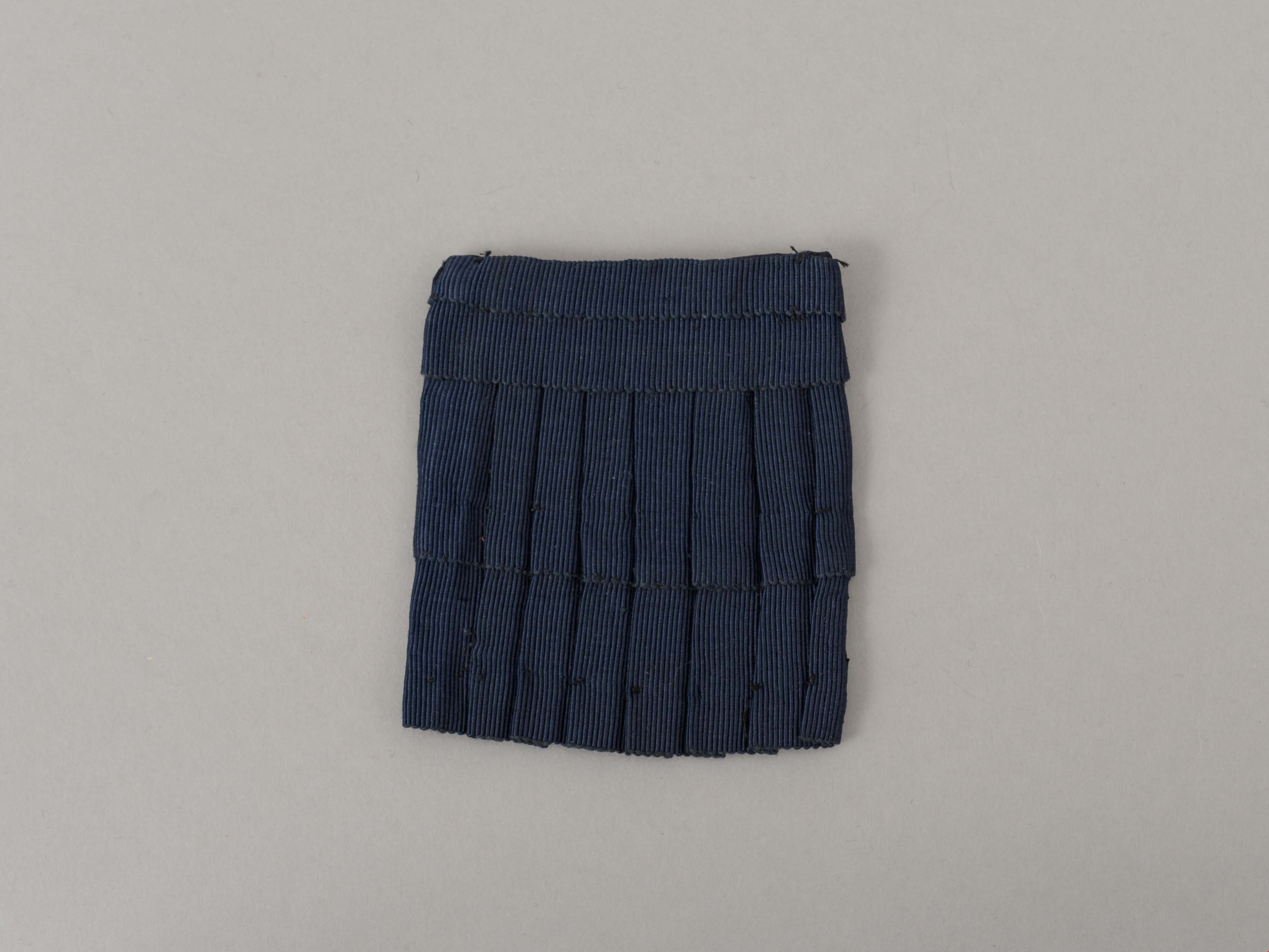
cockade
https://search.heritageburnaby.ca/link/museumartifact87608
- Repository
- Burnaby Village Museum
- Accession Code
- BV015.35.149
- Description
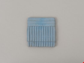
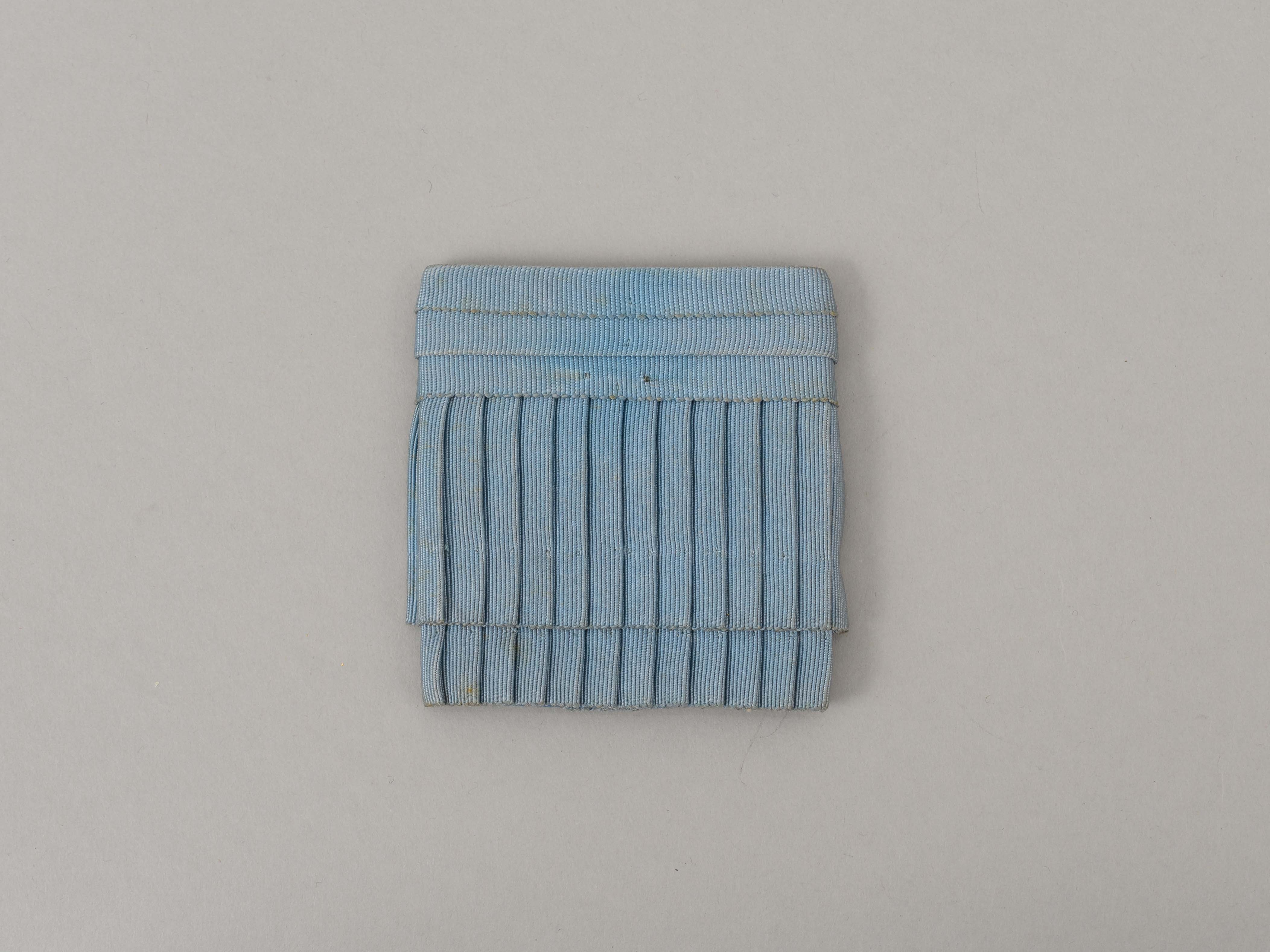
- cockade, Girl Guides; Saxe blue grosgrain ribbon cockade; indicates position of District Commissioner; worn on hat; in use 1922-1948
- Reference
- http://www.girlguides.ca/WEB/Documents/ON/Archives/Insignia_Commissioners.pdf
- Category
- 03. Personal Artifacts
- Classification
- Adornment
- Personal Symbols
- Personal Symbols - - Personal Identification
- Personal Symbols - - Status Symbols
- Subjects
- Adornment
- Personal Symbols - Ribbons
- Organizations
- Organizations - Girls' Societies and Clubs
- Names
- Girl Guides of Canada
Images

Construction on Acorn Avenue
https://search.heritageburnaby.ca/link/archivedescription79040
- Repository
- City of Burnaby Archives
- Date
- October 20, 1976
- Collection/Fonds
- Burnaby Public Library Contemporary Visual Archive Project
- Description Level
- Item
- Physical Description
- 1 photograph : b&w ; 11 x 16 cm mounted on cardboard
- Scope and Content
- Photograph shows a view from Hall Towers of houses and a high-rise under construction on Acorn Avenue.
- Repository
- City of Burnaby Archives
- Date
- October 20, 1976
- Collection/Fonds
- Burnaby Public Library Contemporary Visual Archive Project
- Physical Description
- 1 photograph : b&w ; 11 x 16 cm mounted on cardboard
- Description Level
- Item
- Record No.
- 556-108
- Access Restriction
- No restrictions
- Reproduction Restriction
- Reproduce for fair dealing purposes only
- Accession Number
- 2013-13
- Scope and Content
- Photograph shows a view from Hall Towers of houses and a high-rise under construction on Acorn Avenue.
- Media Type
- Photograph
- Photographer
- Ross, Martha
- Notes
- Scope note taken directly from BPL photograph description.
- 1 b&w copy negative : 10 x 12.5 cm accompanying
- Geographic Access
- Acorn Avenue
- Historic Neighbourhood
- Edmonds (Historic Neighbourhood)
- Planning Study Area
- Stride Avenue Area
Images


Corner of McGill and Gilmore
https://search.heritageburnaby.ca/link/archivedescription78894
- Repository
- City of Burnaby Archives
- Date
- September 5, 1976
- Collection/Fonds
- Burnaby Public Library Contemporary Visual Archive Project
- Description Level
- Item
- Physical Description
- 1 photograph : b&w ; 11 x 16 cm mounted on cardboard
- Scope and Content
- Photograph shows view of houses and the North Shore from the corner of McGill Street and Gilmore Avenue.
- Repository
- City of Burnaby Archives
- Date
- September 5, 1976
- Collection/Fonds
- Burnaby Public Library Contemporary Visual Archive Project
- Physical Description
- 1 photograph : b&w ; 11 x 16 cm mounted on cardboard
- Description Level
- Item
- Record No.
- 556-019
- Access Restriction
- No restrictions
- Reproduction Restriction
- Reproduce for fair dealing purposes only
- Accession Number
- 2013-13
- Scope and Content
- Photograph shows view of houses and the North Shore from the corner of McGill Street and Gilmore Avenue.
- Subjects
- Aerial Photographs
- Media Type
- Photograph
- Notes
- Scope note taken directly from BPL photograph description.
- 1 b&w copy negative : 10 x 12.5 cm accompanying
- Photographers identified by surnames only: Carr and Vardeman
- Geographic Access
- McGill Street
- Gilmore Avenue
- Historic Neighbourhood
- Vancouver Heights (Historic Neighbourhood)
- Planning Study Area
- Burnaby Heights Area
Images

![Deer Lake and Sperling Avenue, [1946] (date of original), copied 1991 thumbnail](/media/hpo/_Data/_Archives_Images/_Unrestricted/370/370-533.jpg?width=280)
Deer Lake and Sperling Avenue
https://search.heritageburnaby.ca/link/archivedescription37946
- Repository
- City of Burnaby Archives
- Date
- [1946] (date of original), copied 1991
- Collection/Fonds
- Burnaby Historical Society fonds
- Description Level
- Item
- Physical Description
- 1 photograph : b&w ; 3.5 x 4.4 cm print on contact sheet 20.5 x 26.7 cm
- Scope and Content
- Aerial photograph of Deer Lake and the Sperling Avenue area facing north.
- Repository
- City of Burnaby Archives
- Date
- [1946] (date of original), copied 1991
- Collection/Fonds
- Burnaby Historical Society fonds
- Subseries
- Burnaby Image Bank subseries
- Physical Description
- 1 photograph : b&w ; 3.5 x 4.4 cm print on contact sheet 20.5 x 26.7 cm
- Description Level
- Item
- Record No.
- 370-533
- Access Restriction
- No restrictions
- Reproduction Restriction
- No known restrictions
- Accession Number
- BHS1999-03
- Scope and Content
- Aerial photograph of Deer Lake and the Sperling Avenue area facing north.
- Media Type
- Photograph
- Notes
- Title based on contents of photograph
- 1 b&w copy negative accompanying
- Negative has a pink cast
- Geographic Access
- Deer Lake
- Sperling Avenue
- Historic Neighbourhood
- Burnaby Lake (Historic Neighbourhood)
- Planning Study Area
- Morley-Buckingham Area
Images
![Deer Lake and Sperling Avenue, [1946] (date of original), copied 1991 thumbnail](/media/hpo/_Data/_Archives_Images/_Unrestricted/370/370-533.jpg)

Edmonds Neighbourhood
https://search.heritageburnaby.ca/link/archivedescription79945
- Repository
- City of Burnaby Archives
- Date
- October 20, 1976
- Collection/Fonds
- Burnaby Public Library Contemporary Visual Archive Project
- Description Level
- Item
- Physical Description
- 1 photograph : b&w ; 11 x 16 cm mounted on cardboard
- Scope and Content
- Photograph shows a view of the neighbourhood south of Kingsway and Edmonds Street. The photo was taken from Hall Towers.
- Repository
- City of Burnaby Archives
- Date
- October 20, 1976
- Collection/Fonds
- Burnaby Public Library Contemporary Visual Archive Project
- Physical Description
- 1 photograph : b&w ; 11 x 16 cm mounted on cardboard
- Description Level
- Item
- Record No.
- 556-516
- Access Restriction
- No restrictions
- Reproduction Restriction
- Reproduce for fair dealing purposes only
- Accession Number
- 2013-13
- Scope and Content
- Photograph shows a view of the neighbourhood south of Kingsway and Edmonds Street. The photo was taken from Hall Towers.
- Subjects
- Aerial Photographs
- Media Type
- Photograph
- Photographer
- Ross, Martha
- Notes
- Scope note taken directly from BPL photograph description.
- 1 b&w copy negative : 10 x 12.5 cm accompanying
- Historic Neighbourhood
- Edmonds (Historic Neighbourhood)
Images

![The Fair Haven, [between 1950 and 1957] thumbnail](/media/Hpo/_Data/_Archives_Images/_Unrestricted/251/305-001.jpg?width=280)
The Fair Haven
https://search.heritageburnaby.ca/link/archivedescription36597
- Repository
- City of Burnaby Archives
- Date
- [between 1950 and 1957]
- Collection/Fonds
- Burnaby Historical Society fonds
- Description Level
- Item
- Physical Description
- 1 photograph : col. postcard ; 9 x 14 cm
- Scope and Content
- Aerial photographic postcard of "the Fair Haven," a group of United Church homes for Senior Citizens. The road in the foreground is Rumble Street, and the long road to the right is Sussex Avenue. The small forest behind "the Fair Haven" is the David Gary Park.
- Repository
- City of Burnaby Archives
- Date
- [between 1950 and 1957]
- Collection/Fonds
- Burnaby Historical Society fonds
- Subseries
- Vera Jackson Pel subseries
- Physical Description
- 1 photograph : col. postcard ; 9 x 14 cm
- Description Level
- Item
- Record No.
- 305-001
- Access Restriction
- No restrictions
- Reproduction Restriction
- Reproduce for fair dealing purposes only
- Accession Number
- BHS1992-46
- Scope and Content
- Aerial photographic postcard of "the Fair Haven," a group of United Church homes for Senior Citizens. The road in the foreground is Rumble Street, and the long road to the right is Sussex Avenue. The small forest behind "the Fair Haven" is the David Gary Park.
- Subjects
- Aerial Photographs
- Documentary Artifacts - Postcards
- Buildings - Residential - Seniors Housing
- Names
- Fair Haven
- Media Type
- Photograph
- Notes
- Typewritten note on verso of postcard reads: "AERIAL VIEW/ 'The Fairhaven', Burnaby BC / United Church Homes for Senior Citizens / 4341 Rumble St., Burnaby, BC"
- Handwritten note on verso of postcard reads: ""The road in the foreground is Rumble Street. The long road to the right is Sussex Avenue. The road, going up, on the left, barely visible is McKay Avenue = lower corner. Behind Fair Haven is the future David Gary Park cleared in the late 1950's - then more trees were felled in October 1962 with Hurricane Freda (blown over, uprooted trees) that left the park as it is today in 1993. The top row of little (5) white cottages were moved from the N.W. corner of Willingdon and Kingsway where Old Orchard Mall is now - they were part of Old Orchard Auto Villas, the first Fair Havens. Note: All cottages on right side of Lodge have been moved to Vancouver Island in 1991 for Motel units - by barge."
- Printed on verso of postcard: "Traveltime product, made in Vancouver, Canada, by Grant-Mann Lithographers Ltd."
- Geographic Access
- Rumble Street
- Street Address
- 4341 Rumble Street
- Historic Neighbourhood
- Alta-Vista (Historic Neighbourhood)
- Planning Study Area
- Sussex-Nelson Area
Images
![The Fair Haven, [between 1950 and 1957] thumbnail](/media/Hpo/_Data/_Archives_Images/_Unrestricted/251/305-001.jpg)
![George Derby Health Centre, [between 1950 and 1954] (date of original), copied 1991 thumbnail](/media/hpo/_Data/_Archives_Images/_Unrestricted/370/370-127.jpg?width=280)
George Derby Health Centre
https://search.heritageburnaby.ca/link/archivedescription37539
- Repository
- City of Burnaby Archives
- Date
- [between 1950 and 1954] (date of original), copied 1991
- Collection/Fonds
- Burnaby Historical Society fonds
- Description Level
- Item
- Physical Description
- 1 photograph : b&w ; 3.4 x 5.0 cm print on contact sheet 20.2 x 25.3 cm
- Scope and Content
- Aerial photograph of the George Derby Health Centre, copied from a postcard.
- Repository
- City of Burnaby Archives
- Date
- [between 1950 and 1954] (date of original), copied 1991
- Collection/Fonds
- Burnaby Historical Society fonds
- Subseries
- Burnaby Image Bank subseries
- Physical Description
- 1 photograph : b&w ; 3.4 x 5.0 cm print on contact sheet 20.2 x 25.3 cm
- Description Level
- Item
- Record No.
- 370-127
- Access Restriction
- No restrictions
- Reproduction Restriction
- No restrictions
- Accession Number
- BHS1999-03
- Scope and Content
- Aerial photograph of the George Derby Health Centre, copied from a postcard.
- Media Type
- Photograph
- Notes
- Title based on caption on photograph
- 1 b&w copy negative accompanying
- Caption on photograph reads, "George Derby Health Centre, Burnaby B.C."
- Geographic Access
- Cumberland Street
- Street Address
- 7550 Cumberland Street
- Historic Neighbourhood
- East Burnaby (Historic Neighbourhood)
- Planning Study Area
- Cariboo-Armstrong Area
Images
![George Derby Health Centre, [between 1950 and 1954] (date of original), copied 1991 thumbnail](/media/hpo/_Data/_Archives_Images/_Unrestricted/370/370-127.jpg)
![Germany, [1880] thumbnail](/media/hpo/_Data/_Archives_Images/_Unrestricted/477/477-799.jpg?width=280)
Germany
https://search.heritageburnaby.ca/link/archivedescription39480
- Repository
- City of Burnaby Archives
- Date
- [1880]
- Collection/Fonds
- Peers Family and Hill Family fonds
- Description Level
- Item
- Physical Description
- 1 photograph : b&w ; 9.3 x 15.7 cm on page 21.5 x 28 cm (pasted in album)
- Scope and Content
- Photograph of an unidentified city along a river in Germany. This item was in a scrapbook kept by Claude Hill who was originally from England but ultimately settled in the Burnaby Lake area.
- Repository
- City of Burnaby Archives
- Date
- [1880]
- Collection/Fonds
- Peers Family and Hill Family fonds
- Physical Description
- 1 photograph : b&w ; 9.3 x 15.7 cm on page 21.5 x 28 cm (pasted in album)
- Description Level
- Item
- Record No.
- 477-799
- Access Restriction
- No restrictions
- Reproduction Restriction
- No known restrictions
- Accession Number
- 2007-12
- Scope and Content
- Photograph of an unidentified city along a river in Germany. This item was in a scrapbook kept by Claude Hill who was originally from England but ultimately settled in the Burnaby Lake area.
- Media Type
- Photograph
- Notes
- Title based on contents of photograph
Images
![Germany, [1880] thumbnail](/media/hpo/_Data/_Archives_Images/_Unrestricted/477/477-799.jpg)

Hastings Street
https://search.heritageburnaby.ca/link/archivedescription79969
- Repository
- City of Burnaby Archives
- Date
- October, 1976
- Collection/Fonds
- Burnaby Public Library Contemporary Visual Archive Project
- Description Level
- Item
- Physical Description
- 1 photograph : b&w ; 11 x 16 cm mounted on cardboard
- Scope and Content
- Photograph shows a view of Hastings Street looking west from the end of Hastings Street on Burnaby Mountain.
- Repository
- City of Burnaby Archives
- Date
- October, 1976
- Collection/Fonds
- Burnaby Public Library Contemporary Visual Archive Project
- Physical Description
- 1 photograph : b&w ; 11 x 16 cm mounted on cardboard
- Description Level
- Item
- Record No.
- 556-532
- Access Restriction
- No restrictions
- Reproduction Restriction
- Reproduce for fair dealing purposes only
- Accession Number
- 2013-13
- Scope and Content
- Photograph shows a view of Hastings Street looking west from the end of Hastings Street on Burnaby Mountain.
- Subjects
- Aerial Photographs
- Media Type
- Photograph
- Photographer
- Cook, Alan
- Notes
- Scope note taken directly from BPL photograph description.
- 1 b&w copy negative : 10 x 12.5 cm accompanying
- Geographic Access
- Hastings Street
- Planning Study Area
- Burnaby Mountain Area
Images


Hastings Street
https://search.heritageburnaby.ca/link/archivedescription79980
- Repository
- City of Burnaby Archives
- Date
- October, 1976
- Collection/Fonds
- Burnaby Public Library Contemporary Visual Archive Project
- Description Level
- Item
- Physical Description
- 1 photograph : b&w ; 11 x 16 cm mounted on cardboard
- Scope and Content
- Photograph shows view of Hastings Street looking east from Rosser Avenue toward Capitol Hill.
- Repository
- City of Burnaby Archives
- Date
- October, 1976
- Collection/Fonds
- Burnaby Public Library Contemporary Visual Archive Project
- Physical Description
- 1 photograph : b&w ; 11 x 16 cm mounted on cardboard
- Description Level
- Item
- Record No.
- 556-536
- Access Restriction
- No restrictions
- Reproduction Restriction
- Reproduce for fair dealing purposes only
- Accession Number
- 2013-13
- Scope and Content
- Photograph shows view of Hastings Street looking east from Rosser Avenue toward Capitol Hill.
- Subjects
- Aerial Photographs
- Media Type
- Photograph
- Photographer
- Cook, Alan
- Notes
- Scope note taken directly from BPL photograph description.
- 1 b&w copy negative : 10 x 12.5 cm accompanying
- Geographic Access
- Hastings Street
- Historic Neighbourhood
- Vancouver Heights (Historic Neighbourhood)
- Planning Study Area
- Burnaby Heights Area
Images

![Heidelberg, Germany, [1880] thumbnail](/media/hpo/_Data/_Archives_Images/_Unrestricted/477/477-795.jpg?width=280)
Heidelberg, Germany
https://search.heritageburnaby.ca/link/archivedescription39476
- Repository
- City of Burnaby Archives
- Date
- [1880]
- Collection/Fonds
- Peers Family and Hill Family fonds
- Description Level
- Item
- Physical Description
- 1 photograph : sepia ; 10 x 15 cm on page 21.5 x 28 cm (pasted in album)
- Scope and Content
- Photograph of Heidelberg, Germany. This item was in a scrapbook kept by Claude Hill who was originally from England but ultimately settled in the Burnaby Lake area.
- Repository
- City of Burnaby Archives
- Date
- [1880]
- Collection/Fonds
- Peers Family and Hill Family fonds
- Physical Description
- 1 photograph : sepia ; 10 x 15 cm on page 21.5 x 28 cm (pasted in album)
- Description Level
- Item
- Record No.
- 477-795
- Access Restriction
- No restrictions
- Reproduction Restriction
- No known restrictions
- Accession Number
- 2007-12
- Scope and Content
- Photograph of Heidelberg, Germany. This item was in a scrapbook kept by Claude Hill who was originally from England but ultimately settled in the Burnaby Lake area.
- Subjects
- Aerial Photographs
- Media Type
- Photograph
- Notes
- Title based on contents of photograph
Images
![Heidelberg, Germany, [1880] thumbnail](/media/hpo/_Data/_Archives_Images/_Unrestricted/477/477-795.jpg)

Highway No. 1
https://search.heritageburnaby.ca/link/archivedescription79950
- Repository
- City of Burnaby Archives
- Date
- September, 1976
- Collection/Fonds
- Burnaby Public Library Contemporary Visual Archive Project
- Description Level
- Item
- Physical Description
- 1 photograph : b&w ; 11 x 16 cm mounted on cardboard
- Scope and Content
- Photograph shows a view of the No. 1 Highway looking northwest from Sprott Street overpass.
- Repository
- City of Burnaby Archives
- Date
- September, 1976
- Collection/Fonds
- Burnaby Public Library Contemporary Visual Archive Project
- Physical Description
- 1 photograph : b&w ; 11 x 16 cm mounted on cardboard
- Description Level
- Item
- Record No.
- 556-520
- Access Restriction
- No restrictions
- Reproduction Restriction
- Reproduce for fair dealing purposes only
- Accession Number
- 2013-13
- Scope and Content
- Photograph shows a view of the No. 1 Highway looking northwest from Sprott Street overpass.
- Subjects
- Aerial Photographs
- Media Type
- Photograph
- Photographer
- Salmon, Stu
- Notes
- Scope note taken directly from BPL photograph description.
- 1 b&w copy negative : 10 x 12.5 cm accompanying
- Geographic Access
- Trans Canada Highway
- Historic Neighbourhood
- Burnaby Lake (Historic Neighbourhood)
- Planning Study Area
- Douglas-Gilpin Area
Images


Highway No. 1
https://search.heritageburnaby.ca/link/archivedescription79977
- Repository
- City of Burnaby Archives
- Date
- September 23, 1976
- Collection/Fonds
- Burnaby Public Library Contemporary Visual Archive Project
- Description Level
- Item
- Physical Description
- 1 photograph : b&w ; 11 x 16 cm mounted on cardboard
- Scope and Content
- Photograph shows a view of underdeveloped area and the No. 1 Highway looking northwest from the Sperling Overpass with Capitol Hill in the background.
- Repository
- City of Burnaby Archives
- Date
- September 23, 1976
- Collection/Fonds
- Burnaby Public Library Contemporary Visual Archive Project
- Physical Description
- 1 photograph : b&w ; 11 x 16 cm mounted on cardboard
- Description Level
- Item
- Record No.
- 556-533
- Access Restriction
- No restrictions
- Reproduction Restriction
- Reproduce for fair dealing purposes only
- Accession Number
- 2013-13
- Scope and Content
- Photograph shows a view of underdeveloped area and the No. 1 Highway looking northwest from the Sperling Overpass with Capitol Hill in the background.
- Subjects
- Aerial Photographs
- Media Type
- Photograph
- Photographer
- Campbell, Peg
- Notes
- Scope note taken directly from BPL photograph description.
- 1 b&w copy negative : 10 x 12.5 cm accompanying
- Geographic Access
- Trans Canada Highway
- Planning Study Area
- Ardingley-Sprott Area
Images


Homes near Keith and McGregor
https://search.heritageburnaby.ca/link/archivedescription79946
- Repository
- City of Burnaby Archives
- Date
- September 16, 1976
- Collection/Fonds
- Burnaby Public Library Contemporary Visual Archive Project
- Description Level
- Item
- Physical Description
- 1 photograph : b&w ; 11 x 16 cm mounted on cardboard
- Scope and Content
- Photograph shows a view of backyards of houses near Keith Street and McGregor Avenue with the flats south of Marine Drive in the background.
- Repository
- City of Burnaby Archives
- Date
- September 16, 1976
- Collection/Fonds
- Burnaby Public Library Contemporary Visual Archive Project
- Physical Description
- 1 photograph : b&w ; 11 x 16 cm mounted on cardboard
- Description Level
- Item
- Record No.
- 556-517
- Access Restriction
- No restrictions
- Reproduction Restriction
- Reproduce for fair dealing purposes only
- Accession Number
- 2013-13
- Scope and Content
- Photograph shows a view of backyards of houses near Keith Street and McGregor Avenue with the flats south of Marine Drive in the background.
- Subjects
- Aerial Photographs
- Media Type
- Photograph
- Photographer
- Ross, Martha
- Notes
- Scope note taken directly from BPL photograph description.
- 1 b&w copy negative : 10 x 12.5 cm accompanying
- Geographic Access
- McGregor Avenue
- Keith Street
- Historic Neighbourhood
- Alta-Vista (Historic Neighbourhood)
- Planning Study Area
- Sussex-Nelson Area
Images


Kingsway
https://search.heritageburnaby.ca/link/archivedescription79943
- Repository
- City of Burnaby Archives
- Date
- September 15, 1976
- Collection/Fonds
- Burnaby Public Library Contemporary Visual Archive Project
- Description Level
- Item
- Physical Description
- 1 photograph : b&w ; 11 x 16 cm mounted on cardboard
- Scope and Content
- Photograph shows a view of Kingsway looking southeast from the 21st floor of the Panorama Towers in Grange Street. The Esso Car Clinic is in the centre of the photo.
- Repository
- City of Burnaby Archives
- Date
- September 15, 1976
- Collection/Fonds
- Burnaby Public Library Contemporary Visual Archive Project
- Physical Description
- 1 photograph : b&w ; 11 x 16 cm mounted on cardboard
- Description Level
- Item
- Record No.
- 556-514
- Access Restriction
- No restrictions
- Reproduction Restriction
- Reproduce for fair dealing purposes only
- Accession Number
- 2013-13
- Scope and Content
- Photograph shows a view of Kingsway looking southeast from the 21st floor of the Panorama Towers in Grange Street. The Esso Car Clinic is in the centre of the photo.
- Subjects
- Aerial Photographs
- Media Type
- Photograph
- Photographer
- McCarron, John
- Notes
- Scope note taken directly from BPL photograph description.
- 1 b&w copy negative : 10 x 12.5 cm accompanying
- Geographic Access
- Kingsway
- Historic Neighbourhood
- Central Park (Historic Neighbourhood)
- Planning Study Area
- Maywood Area
Images
