Narrow Results By
Subject
- Advertising Medium 1
- Advertising Medium - Signs and Signboards 1
- Aerial Photographs 3
- Animals - Horses 1
- Armament - Firearms 1
- Buildings - Civic 1
- Buildings - Commercial 2
- Buildings - Commercial - Banks 1
- Buildings - Commercial - Grocery Stores 1
- Buildings - Commercial - Hardware Stores 2
- Buildings - Commercial - Restaurants 1
- Buildings - Commercial - Stores 8
![5th Burnaby Brownies and Guides at Willingdon Heights United Church, [ca. 1950] thumbnail](/media/hpo/_Data/_BVM_Images/2015/2015_0035_0186_001.jpg?width=280)
5th Burnaby Brownies and Guides at Willingdon Heights United Church
https://search.heritageburnaby.ca/link/museumdescription4837
- Repository
- Burnaby Village Museum
- Date
- [ca. 1950]
- Collection/Fonds
- Burnaby Girl Guides fonds
- Description Level
- Item
- Physical Description
- 1 photograph : b&w ; 20.5 x 25.5 cm
- Scope and Content
- Photograph of a group of 5th Burnaby Brownies, Guides and their leaders standing on the sidewalk in front of Willingdon Heights United Church.
- Repository
- Burnaby Village Museum
- Collection/Fonds
- Burnaby Girl Guides fonds
- Description Level
- Item
- Physical Description
- 1 photograph : b&w ; 20.5 x 25.5 cm
- Scope and Content
- Photograph of a group of 5th Burnaby Brownies, Guides and their leaders standing on the sidewalk in front of Willingdon Heights United Church.
- Geographic Access
- Parker Street
- Street Address
- 4304 Parker Street
- Accession Code
- BV015.35.186
- Access Restriction
- No restrictions
- Reproduction Restriction
- May be restricted by third party rights
- Date
- [ca. 1950]
- Media Type
- Photograph
- Historic Neighbourhood
- Vancouver Heights (Historic Neighbourhood)
- Planning Study Area
- Willingdon Heights Area
- Scan Resolution
- 600
- Scan Date
- March 9, 2021
- Scale
- 100
- Notes
- Title based on contents of photograph
- Photograph is a part of original scrapbook "5th Brownie Pack" 1948-1965 Item BV015.35.156
Images
![5th Burnaby Brownies and Guides at Willingdon Heights United Church, [ca. 1950] thumbnail](/media/hpo/_Data/_BVM_Images/2015/2015_0035_0186_001.jpg)

100 Years of Gilmore School
https://search.heritageburnaby.ca/link/museumdescription4488
- Repository
- Burnaby Village Museum
- Date
- 2017
- Collection/Fonds
- 100 Years of Gilmore School video collection
- Description Level
- Item
- Physical Description
- 1 video recording (mp4) (34 min., 23 sec.) : digital, 29 fps, col., sd., stereo
- Scope and Content
- "100 Years of Gilmore School". Filmed by Yunuen Perez Vertti and made by the Heights Neighbourhood Association. The film includes interviews with former students and highlights their experiences through the Great Depression, the Second World War and the 1960s.
- Repository
- Burnaby Village Museum
- Collection/Fonds
- 100 Years of Gilmore School video collection
- Description Level
- Item
- Physical Description
- 1 video recording (mp4) (34 min., 23 sec.) : digital, 29 fps, col., sd., stereo
- Scope and Content
- "100 Years of Gilmore School". Filmed by Yunuen Perez Vertti and made by the Heights Neighbourhood Association. The film includes interviews with former students and highlights their experiences through the Great Depression, the Second World War and the 1960s.
- History
- Yunuen Perez Vertti is a filmmaker and digital media artist originally from Mexico City. She has produced films for many public, private and non-profit organizations.
- Creator
- Perez Vertti, Yunuen
- Names
- Gilmore Avenue School
- Responsibility
- Heights Neighbourhood Association
- Geographic Access
- Gilmore Avenue
- Street Address
- 50 Gilmore Avenue
- Accession Code
- BV018.13.1
- Access Restriction
- Restricted access
- Reproduction Restriction
- May be restricted by third party rights
- Date
- 2017
- Media Type
- Moving Images
- Historic Neighbourhood
- Vancouver Heights (Historic Neighbourhood)
- Planning Study Area
- Burnaby Heights Area
- Notes
- Transcribed title
- Reproductions are restricted by copyright holder
Images

Video
100 Years of Gilmore School, 2017
100 Years of Gilmore School, 2017
https://search.heritageburnaby.ca/media/hpo/_Data/_BVM_Moving_Images/2018_0013_0001_001.mp4![311 Madison Avenue, [1949 or 1950] (date of original), copied 1991 thumbnail](/media/hpo/_Data/_Archives_Images/_Unrestricted/370/370-204.jpg?width=280)
311 Madison Avenue
https://search.heritageburnaby.ca/link/archivedescription37616
- Repository
- City of Burnaby Archives
- Date
- [1949 or 1950] (date of original), copied 1991
- Collection/Fonds
- Burnaby Historical Society fonds
- Description Level
- Item
- Physical Description
- 1 photograph : b&w ; 3.0 x 4.5 cm print on contact sheet 20.2 x 25.3 cm
- Scope and Content
- Photograph of a side view of 311 Madison Avenue, in the snow. The photograph was taken from Madison Avenue.
- Repository
- City of Burnaby Archives
- Date
- [1949 or 1950] (date of original), copied 1991
- Collection/Fonds
- Burnaby Historical Society fonds
- Subseries
- Burnaby Image Bank subseries
- Physical Description
- 1 photograph : b&w ; 3.0 x 4.5 cm print on contact sheet 20.2 x 25.3 cm
- Description Level
- Item
- Record No.
- 370-204
- Access Restriction
- No restrictions
- Reproduction Restriction
- No restrictions
- Accession Number
- BHS1999-03
- Scope and Content
- Photograph of a side view of 311 Madison Avenue, in the snow. The photograph was taken from Madison Avenue.
- Media Type
- Photograph
- Notes
- Title based on contents of photograph
- 1 b&w copy negative accompanying
- Geographic Access
- Madison Avenue
- Street Address
- 311 Madison Avenue
- Historic Neighbourhood
- Vancouver Heights (Historic Neighbourhood)
- Planning Study Area
- Burnaby Heights Area
Images
![311 Madison Avenue, [1949 or 1950] (date of original), copied 1991 thumbnail](/media/hpo/_Data/_Archives_Images/_Unrestricted/370/370-204.jpg)
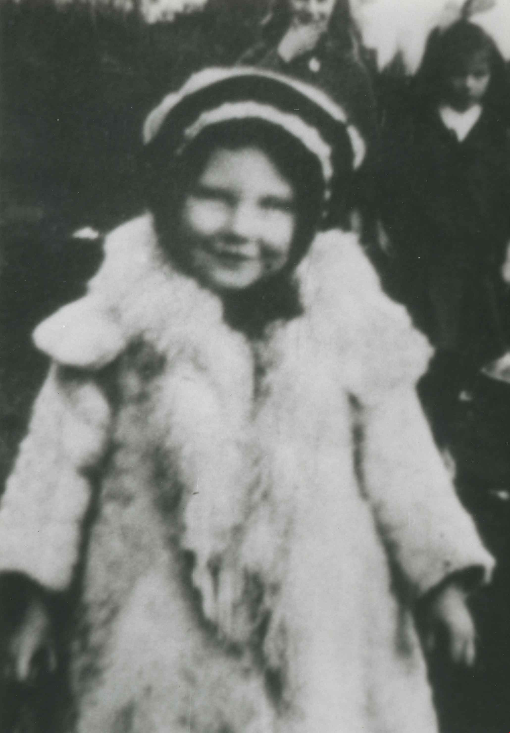
![3900 Block Union Street, [between 1912 and 1915] (date of original), copied 1991 thumbnail](/media/hpo/_Data/_Archives_Images/_Unrestricted/370/370-772.jpg?width=280)
3900 Block Union Street
https://search.heritageburnaby.ca/link/archivedescription38185
- Repository
- City of Burnaby Archives
- Date
- [between 1912 and 1915] (date of original), copied 1991
- Collection/Fonds
- Burnaby Historical Society fonds
- Description Level
- Item
- Physical Description
- 1 photograph : b&w ; 4.4 x 3.4 cm print on contact sheet 20.6 x 26.5 cm
- Scope and Content
- Photograph of the Spraggon family home and another house on the 3900 block of Union Street (formerly named Barnard Street). There is a child at play in the snow in the foreground.
- Repository
- City of Burnaby Archives
- Date
- [between 1912 and 1915] (date of original), copied 1991
- Collection/Fonds
- Burnaby Historical Society fonds
- Subseries
- Burnaby Image Bank subseries
- Physical Description
- 1 photograph : b&w ; 4.4 x 3.4 cm print on contact sheet 20.6 x 26.5 cm
- Description Level
- Item
- Record No.
- 370-772
- Access Restriction
- No restrictions
- Reproduction Restriction
- No known restrictions
- Accession Number
- BHS1999-03
- Scope and Content
- Photograph of the Spraggon family home and another house on the 3900 block of Union Street (formerly named Barnard Street). There is a child at play in the snow in the foreground.
- Media Type
- Photograph
- Notes
- Title based on contents of photograph
- 1 b&w copy negative accompanying
- Negative has a pink cast
- Geographic Access
- Union Street
- Historic Neighbourhood
- Vancouver Heights (Historic Neighbourhood)
- Planning Study Area
- Willingdon Heights Area
Images
![3900 Block Union Street, [between 1912 and 1915] (date of original), copied 1991 thumbnail](/media/hpo/_Data/_Archives_Images/_Unrestricted/370/370-772.jpg)
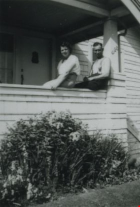
4123 Oxford Street
https://search.heritageburnaby.ca/link/archivedescription38197
- Repository
- City of Burnaby Archives
- Date
- 1953 (date of original), copied 1991
- Collection/Fonds
- Burnaby Historical Society fonds
- Description Level
- Item
- Physical Description
- 1 photograph : b&w ; 4.2 x 2.8 cm print on contact sheet 20.3 x 26.6 cm
- Scope and Content
- Photograph of a woman and a man sitting on the edge of the porch at 4123 Oxford Street.
- Repository
- City of Burnaby Archives
- Date
- 1953 (date of original), copied 1991
- Collection/Fonds
- Burnaby Historical Society fonds
- Subseries
- Burnaby Image Bank subseries
- Physical Description
- 1 photograph : b&w ; 4.2 x 2.8 cm print on contact sheet 20.3 x 26.6 cm
- Description Level
- Item
- Record No.
- 370-784
- Access Restriction
- No restrictions
- Reproduction Restriction
- No restrictions
- Accession Number
- BHS1999-03
- Scope and Content
- Photograph of a woman and a man sitting on the edge of the porch at 4123 Oxford Street.
- Media Type
- Photograph
- Notes
- Title based on contents of photograph
- 1 b&w copy negative accompanying
- Geographic Access
- Oxford Street
- Street Address
- 4123 Oxford Street
- Historic Neighbourhood
- Vancouver Heights (Historic Neighbourhood)
- Planning Study Area
- Burnaby Heights Area
Images


4297 Albert Street
https://search.heritageburnaby.ca/link/archivedescription37591
- Repository
- City of Burnaby Archives
- Date
- 1951 (date of original), copied 1991
- Collection/Fonds
- Burnaby Historical Society fonds
- Description Level
- Item
- Physical Description
- 1 photograph : b&w ; 2.7 x 4.2 cm print on contact sheet 20.2 x 25.3 cm
- Scope and Content
- Photograph of 4297 Albert Street. Another house is visible in the background.
- Repository
- City of Burnaby Archives
- Date
- 1951 (date of original), copied 1991
- Collection/Fonds
- Burnaby Historical Society fonds
- Subseries
- Burnaby Image Bank subseries
- Physical Description
- 1 photograph : b&w ; 2.7 x 4.2 cm print on contact sheet 20.2 x 25.3 cm
- Description Level
- Item
- Record No.
- 370-179
- Access Restriction
- No restrictions
- Reproduction Restriction
- No restrictions
- Accession Number
- BHS1999-03
- Scope and Content
- Photograph of 4297 Albert Street. Another house is visible in the background.
- Subjects
- Buildings - Residential - Houses
- Media Type
- Photograph
- Notes
- Title based on contents of photograph
- 1 b&w copy negative accompanying
- Negative has a pink cast
- Geographic Access
- Albert Street
- Street Address
- 4297 Albert Street
- Historic Neighbourhood
- Vancouver Heights (Historic Neighbourhood)
- Planning Study Area
- Burnaby Heights Area
Images


4297 Albert Street
https://search.heritageburnaby.ca/link/archivedescription37592
- Repository
- City of Burnaby Archives
- Date
- 1950 (date of original), copied 1991
- Collection/Fonds
- Burnaby Historical Society fonds
- Description Level
- Item
- Physical Description
- 1 photograph : b&w ; 3.4 x 3.5 cm print on contact sheet 20.2 x 25.3 cm
- Scope and Content
- Photograph of 4297 Albert Street.
- Repository
- City of Burnaby Archives
- Date
- 1950 (date of original), copied 1991
- Collection/Fonds
- Burnaby Historical Society fonds
- Subseries
- Burnaby Image Bank subseries
- Physical Description
- 1 photograph : b&w ; 3.4 x 3.5 cm print on contact sheet 20.2 x 25.3 cm
- Description Level
- Item
- Record No.
- 370-180
- Access Restriction
- No restrictions
- Reproduction Restriction
- No restrictions
- Accession Number
- BHS1999-03
- Scope and Content
- Photograph of 4297 Albert Street.
- Subjects
- Buildings - Residential - Houses
- Media Type
- Photograph
- Notes
- Title based on contents of photograph
- 1 b&w copy negative accompanying
- Negative has a pink cast
- Geographic Access
- Albert Street
- Street Address
- 4297 Albert Street
- Historic Neighbourhood
- Vancouver Heights (Historic Neighbourhood)
- Planning Study Area
- Burnaby Heights Area
Images

![Allan Beaton, [195-] (date of original), copied 1992 thumbnail](/media/hpo/_Data/_Archives_Images/_Unrestricted/315/315-045.jpg?width=280)
Allan Beaton
https://search.heritageburnaby.ca/link/archivedescription36690
- Repository
- City of Burnaby Archives
- Date
- [195-] (date of original), copied 1992
- Collection/Fonds
- Burnaby Historical Society fonds
- Description Level
- Item
- Physical Description
- 1 photograph : b&w ; 11 x 9 cm print
- Scope and Content
- Photograph of Allan Beaton inspecting an apple tree in front of a house.
- Repository
- City of Burnaby Archives
- Date
- [195-] (date of original), copied 1992
- Collection/Fonds
- Burnaby Historical Society fonds
- Subseries
- Burnaby Centennial Anthology subseries
- Physical Description
- 1 photograph : b&w ; 11 x 9 cm print
- Description Level
- Item
- Record No.
- 315-045
- Access Restriction
- No restrictions
- Reproduction Restriction
- Reproduce for fair dealing purposes only
- Accession Number
- BHS1994-04
- Scope and Content
- Photograph of Allan Beaton inspecting an apple tree in front of a house.
- Names
- Beaton, Allan
- Media Type
- Photograph
- Notes
- Title based on contents of photograph
- Geographic Access
- Parker Street
- Street Address
- 3966 Parker Street
- Historic Neighbourhood
- Vancouver Heights (Historic Neighbourhood)
- Planning Study Area
- Willingdon Heights Area
Images
![Allan Beaton, [195-] (date of original), copied 1992 thumbnail](/media/hpo/_Data/_Archives_Images/_Unrestricted/315/315-045.jpg)

Angus & Mabel MacDonald Residence
https://search.heritageburnaby.ca/link/landmark558
- Repository
- Burnaby Heritage Planning
- Description
- Residential building.
- Associated Dates
- 1913
- Other Names
- The Pillars
- Street View URL
- Google Maps Street View
- Repository
- Burnaby Heritage Planning
- Other Names
- The Pillars
- Geographic Access
- Dundas Street
- Associated Dates
- 1913
- Description
- Residential building.
- Heritage Value
- With its two monumental, double height columns terminating in elaborate Ionic capitals, this Neoclassical Revival style house is aptly named The Pillars. Other Neoclassical embellishments include a Palladian pediment window, pilasters with Ionic capitals applied to the front corners of the house and lathe-turned porch columns. Though it has been re-clad with a later covering of asbestos shingles over the original siding, it otherwise retains a high degree of exterior integrity with most of its double-hung windows and decorative elements still in place. This home was constructed for Angus John MacDonald (née Cummins, 1878-1955), Vice-President of A. Linton & Company Ltd., and his wife Mabel Jessie MacDonald (1884-1971). Linton & Company was a shipbuilding firm; MacDonald retired in 1942 after thirty years in the industry. A photograph of this grand house was often featured in the promotional material for the Vancouver Heights subdivision by realtors and titled “A typical Vancouver Heights home.”
- Locality
- Vancouver Heights
- Historic Neighbourhood
- Vancouver Heights (Historic Neighbourhood)
- Planning Study Area
- Burnaby Heights Area
- Area
- 566.71
- Contributing Resource
- Building
- Ownership
- Private
- Street Address
- 3815 Dundas Street
- Street View URL
- Google Maps Street View
Images


![Arthur Wirick, [1917] (date of original), copied 1991 thumbnail](/media/hpo/_Data/_Archives_Images/_Unrestricted/370/370-070.jpg?width=280)
Arthur Wirick
https://search.heritageburnaby.ca/link/archivedescription37482
- Repository
- City of Burnaby Archives
- Date
- [1917] (date of original), copied 1991
- Collection/Fonds
- Burnaby Historical Society fonds
- Description Level
- Item
- Physical Description
- 1 photograph : b&w ; 3.7 x 3.1 cm print on contact sheet 20.2 x 25.3 cm
- Scope and Content
- Photograph of Arthur Wirick, age 2, standing on a board sidewalk in the backyard of 4361 Oxford Street. His family lived there from 1914 to 1924.
- Repository
- City of Burnaby Archives
- Date
- [1917] (date of original), copied 1991
- Collection/Fonds
- Burnaby Historical Society fonds
- Subseries
- Burnaby Image Bank subseries
- Physical Description
- 1 photograph : b&w ; 3.7 x 3.1 cm print on contact sheet 20.2 x 25.3 cm
- Description Level
- Item
- Record No.
- 370-070
- Access Restriction
- No restrictions
- Reproduction Restriction
- No known restrictions
- Accession Number
- BHS1999-03
- Scope and Content
- Photograph of Arthur Wirick, age 2, standing on a board sidewalk in the backyard of 4361 Oxford Street. His family lived there from 1914 to 1924.
- Subjects
- Geographic Features - Sidewalks
- Names
- Wirick, Arthur "Art"
- Media Type
- Photograph
- Notes
- Title based on contents of photograph
- 1 b&w copy negative accompanying
- Geographic Access
- Oxford Street
- Street Address
- 4361 Oxford Street
- Historic Neighbourhood
- Vancouver Heights (Historic Neighbourhood)
- Planning Study Area
- Burnaby Heights Area
Images
![Arthur Wirick, [1917] (date of original), copied 1991 thumbnail](/media/hpo/_Data/_Archives_Images/_Unrestricted/370/370-070.jpg)
![Bank of Montreal, [195-] thumbnail](/media/hpo/_Data/_Archives_Images/_Unrestricted/001/073-001.jpg?width=280)
Bank of Montreal
https://search.heritageburnaby.ca/link/archivedescription34638
- Repository
- City of Burnaby Archives
- Date
- [195-]
- Collection/Fonds
- Burnaby Historical Society fonds
- Description Level
- Item
- Physical Description
- 1 photograph : b&w ; 24.7 x 17.4 cm
- Scope and Content
- Photograph of the exterior of the Bank of Montreal at 418 Willingdon Avenue and Hastings Street.
- Repository
- City of Burnaby Archives
- Date
- [195-]
- Collection/Fonds
- Burnaby Historical Society fonds
- Subseries
- Photographs subseries
- Physical Description
- 1 photograph : b&w ; 24.7 x 17.4 cm
- Description Level
- Item
- Record No.
- 073-001
- Access Restriction
- No restrictions
- Reproduction Restriction
- Reproduce for fair dealing purposes only
- Accession Number
- BHS2007-04
- Scope and Content
- Photograph of the exterior of the Bank of Montreal at 418 Willingdon Avenue and Hastings Street.
- Subjects
- Buildings - Commercial - Banks
- Names
- Bank of Montreal
- Media Type
- Photograph
- Notes
- Title based on contents of photograph
- Geographic Access
- Willingdon Avenue
- Street Address
- 418 Willingdon Avenue
- Historic Neighbourhood
- Vancouver Heights (Historic Neighbourhood)
- Planning Study Area
- Brentwood Area
Images
![Bank of Montreal, [195-] thumbnail](/media/hpo/_Data/_Archives_Images/_Unrestricted/001/073-001.jpg)
![Bea Carpenter, [between 1950 and 1954] (date of original), copied 1991 thumbnail](/media/hpo/_Data/_Archives_Images/_Unrestricted/370/370-130.jpg?width=280)
Bea Carpenter
https://search.heritageburnaby.ca/link/archivedescription37542
- Repository
- City of Burnaby Archives
- Date
- [between 1950 and 1954] (date of original), copied 1991
- Collection/Fonds
- Burnaby Historical Society fonds
- Description Level
- Item
- Physical Description
- 1 photograph : b&w ; 3.5 x 3.6 cm print on contact sheet 20.2 x 25.3 cm
- Scope and Content
- Photograph of Beatrice "Bea" Carpenter at the door of a 1950 Studebaker car parked on Yale Street. The Esmond Avenue intersection is in the background.
- Repository
- City of Burnaby Archives
- Date
- [between 1950 and 1954] (date of original), copied 1991
- Collection/Fonds
- Burnaby Historical Society fonds
- Subseries
- Burnaby Image Bank subseries
- Physical Description
- 1 photograph : b&w ; 3.5 x 3.6 cm print on contact sheet 20.2 x 25.3 cm
- Description Level
- Item
- Record No.
- 370-130
- Access Restriction
- No restrictions
- Reproduction Restriction
- No restrictions
- Accession Number
- BHS1999-03
- Scope and Content
- Photograph of Beatrice "Bea" Carpenter at the door of a 1950 Studebaker car parked on Yale Street. The Esmond Avenue intersection is in the background.
- Media Type
- Photograph
- Notes
- Title based on contents of photograph
- 1 b&w copy negative accompanying
- Geographic Access
- Yale Street
- Esmond Avenue North
- Historic Neighbourhood
- Vancouver Heights (Historic Neighbourhood)
- Planning Study Area
- Burnaby Heights Area
Images
![Bea Carpenter, [between 1950 and 1954] (date of original), copied 1991 thumbnail](/media/hpo/_Data/_Archives_Images/_Unrestricted/370/370-130.jpg)

Bessie Clark
https://search.heritageburnaby.ca/link/archivedescription36826
- Repository
- City of Burnaby Archives
- Date
- 1916 (date of original), copied 1992
- Collection/Fonds
- Burnaby Historical Society fonds
- Description Level
- Item
- Physical Description
- 1 photograph : b&w ; 8.5 x 12.6 cm print
- Scope and Content
- Photograph of Bessie Clark at 4055 Union Street, her family home.
- Repository
- City of Burnaby Archives
- Date
- 1916 (date of original), copied 1992
- Collection/Fonds
- Burnaby Historical Society fonds
- Subseries
- Burnaby Centennial Anthology subseries
- Physical Description
- 1 photograph : b&w ; 8.5 x 12.6 cm print
- Description Level
- Item
- Record No.
- 315-284
- Access Restriction
- No restrictions
- Reproduction Restriction
- No known restrictions
- Accession Number
- BHS1994-04
- Scope and Content
- Photograph of Bessie Clark at 4055 Union Street, her family home.
- Media Type
- Photograph
- Notes
- Title based on contents of photograph
- Geographic Access
- Union Street
- Street Address
- 4055 Union Street
- Historic Neighbourhood
- Vancouver Heights (Historic Neighbourhood)
- Planning Study Area
- Willingdon Heights Area
Images
![Betty Stevenson in the Stevenson family garden, [195-] (date of original), copied 1992 thumbnail](/media/hpo/_Data/_Archives_Images/_Unrestricted/315/315-048.jpg?width=280)
Betty Stevenson in the Stevenson family garden
https://search.heritageburnaby.ca/link/archivedescription36693
- Repository
- City of Burnaby Archives
- Date
- [195-] (date of original), copied 1992
- Collection/Fonds
- Burnaby Historical Society fonds
- Description Level
- Item
- Physical Description
- 1 photograph : b&w ; 8.7 x 10.9 cm print
- Scope and Content
- Photograph of Betty Stevenson in the Stevenson family garden.
- Repository
- City of Burnaby Archives
- Date
- [195-] (date of original), copied 1992
- Collection/Fonds
- Burnaby Historical Society fonds
- Subseries
- Burnaby Centennial Anthology subseries
- Physical Description
- 1 photograph : b&w ; 8.7 x 10.9 cm print
- Description Level
- Item
- Record No.
- 315-048
- Access Restriction
- No restrictions
- Reproduction Restriction
- Reproduce for fair dealing purposes only
- Accession Number
- BHS1994-04
- Scope and Content
- Photograph of Betty Stevenson in the Stevenson family garden.
- Subjects
- Geographic Features - Gardens
- Names
- Stevenson, Betty
- Media Type
- Photograph
- Notes
- Title based on contents of photograph
- Geographic Access
- Parker Street
- Street Address
- 3966 Parker Street
- Historic Neighbourhood
- Vancouver Heights (Historic Neighbourhood)
- Planning Study Area
- Willingdon Heights Area
Images
![Betty Stevenson in the Stevenson family garden, [195-] (date of original), copied 1992 thumbnail](/media/hpo/_Data/_Archives_Images/_Unrestricted/315/315-048.jpg)
![Bird's eye view of New Westminster, Burnaby and Vancouver, [ca. 1911] thumbnail](/media/hpo/_Data/_BVM_Cartographic_Material/1983/1983_0012_0001_002%20Web.jpg?width=280)
Bird's eye view of New Westminster, Burnaby and Vancouver
https://search.heritageburnaby.ca/link/museumdescription8199
- Repository
- Burnaby Village Museum
- Date
- [ca. 1911]
- Collection/Fonds
- Burnaby Village Museum Map collection
- Description Level
- Item
- Physical Description
- 1 map : hand painted ; 65.5 x 99 cm
- Scope and Content
- An untitled monochromatic grayscale map of a developer's bird's eye view looking north west from Burnaby Mountain. View includes Burnaby, New Westminster, Vancouver with the North shore in the distance. Burnaby neighbourhood subdivisions of "Burnaby Heights" and "Buena Vista" are featured near the…
- Repository
- Burnaby Village Museum
- Collection/Fonds
- Burnaby Village Museum Map collection
- Description Level
- Item
- Physical Description
- 1 map : hand painted ; 65.5 x 99 cm
- Scope and Content
- An untitled monochromatic grayscale map of a developer's bird's eye view looking north west from Burnaby Mountain. View includes Burnaby, New Westminster, Vancouver with the North shore in the distance. Burnaby neighbourhood subdivisions of "Burnaby Heights" and "Buena Vista" are featured near the centre of the map. These neighbourhood subdivisions were marketed by Real Estate Agents Liebly & Blumer in 1911. Roads, buildings, factories, railways and bridges are identified on the map.
- Subjects
- Businesses - Real Estate Agencies
- Responsibility
- Leibly & Blumer Realty Co. Incorporated
- Accession Code
- HV983.12.1
- Access Restriction
- No restrictions
- Reproduction Restriction
- No known restrictions
- Date
- [ca. 1911]
- Media Type
- Cartographic Material
- Historic Neighbourhood
- East Burnaby (Historic Neighbourhood)
- Vancouver Heights (Historic Neighbourhood)
- Planning Study Area
- Cariboo-Armstrong Area
- Burnaby Heights Area
- Scan Resolution
- 300
- Scan Date
- December 2020
- Scale
- 100
- Notes
- Title based on contents of map
- Note in pencil on verso of photograph reads: "Make tint block of Buena Vista / Blocks only as shown in lots"
Zoomable Images
![Bird's eye view of New Westminster, Burnaby and Vancouver, [ca. 1911] thumbnail](/media/hpo/_Data/_BVM_Cartographic_Material/1983/1983_0012_0001_001_seadragon/1983_0012_0001_001.jpg?w=280)

Boundary Road and Hastings Street vicinity
https://search.heritageburnaby.ca/link/archivedescription35447
- Repository
- City of Burnaby Archives
- Date
- 1915 (date of original), copied 1986
- Collection/Fonds
- Burnaby Historical Society fonds
- Description Level
- Item
- Physical Description
- 1 photograph : b&w ; 12.7 x 17.8 cm print
- Scope and Content
- Photograph taken in Vancouver on Hastings Street looking east toward Burnaby and Boundary Road. The Hastings Street British Columbia Electric Railway (BCER) cars can be seen labouring up the hill.
- Repository
- City of Burnaby Archives
- Date
- 1915 (date of original), copied 1986
- Collection/Fonds
- Burnaby Historical Society fonds
- Subseries
- Pioneer Tales subseries
- Physical Description
- 1 photograph : b&w ; 12.7 x 17.8 cm print
- Description Level
- Item
- Record No.
- 204-305
- Access Restriction
- No restrictions
- Reproduction Restriction
- No restrictions
- Accession Number
- BHS1988-03
- Scope and Content
- Photograph taken in Vancouver on Hastings Street looking east toward Burnaby and Boundary Road. The Hastings Street British Columbia Electric Railway (BCER) cars can be seen labouring up the hill.
- Media Type
- Photograph
- Photographer
- Eaton, Dr. Carl
- Notes
- Title based on contents of photograph
- Geographic Access
- Boundary Road
- Hastings Street
- Historic Neighbourhood
- Vancouver Heights (Historic Neighbourhood)
- Planning Study Area
- Willingdon Heights Area
Images

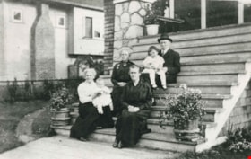
Brown family
https://search.heritageburnaby.ca/link/archivedescription35674
- Repository
- City of Burnaby Archives
- Date
- 1917 (date of original), copied 1986
- Collection/Fonds
- Burnaby Historical Society fonds
- Description Level
- Item
- Physical Description
- 1 photograph : b&w ; 12.7 x 17.8 cm print
- Scope and Content
- Photograph of the Brown family. Identified: (from left) Janet Maclean (grandmother), Alex Brown (brother), Janet Brown (sister), carried by a grand-uncle. The others in the photo are unidentified. This may have been taken at the Brown family home at 3846 Triumph Street.
- Repository
- City of Burnaby Archives
- Date
- 1917 (date of original), copied 1986
- Collection/Fonds
- Burnaby Historical Society fonds
- Subseries
- Pioneer Tales subseries
- Physical Description
- 1 photograph : b&w ; 12.7 x 17.8 cm print
- Description Level
- Item
- Record No.
- 204-532
- Access Restriction
- No restrictions
- Reproduction Restriction
- No known restrictions
- Accession Number
- BHS1988-03
- Scope and Content
- Photograph of the Brown family. Identified: (from left) Janet Maclean (grandmother), Alex Brown (brother), Janet Brown (sister), carried by a grand-uncle. The others in the photo are unidentified. This may have been taken at the Brown family home at 3846 Triumph Street.
- Media Type
- Photograph
- Notes
- Title based on contents of photograph
- Geographic Access
- Triumph Street
- Street Address
- 3846 Triumph Street
- Historic Neighbourhood
- Vancouver Heights (Historic Neighbourhood)
- Planning Study Area
- Burnaby Heights Area
Images
Brown-John family
https://search.heritageburnaby.ca/link/archivedescription76887
- Repository
- City of Burnaby Archives
- Date
- 1914 (date of original), digitally copied 2012
- Collection/Fonds
- Community Heritage Commission Special Projects fonds
- Description Level
- Item
- Physical Description
- 1 photograph (jpeg) : col. ; 300ppi
- Scope and Content
- Photograph of the Brown-John family; Victor, his wife Winnifred, their two eldest sons Victor and Archie, and twin boys Frank and Roy.
- Repository
- City of Burnaby Archives
- Date
- 1914 (date of original), digitally copied 2012
- Collection/Fonds
- Community Heritage Commission Special Projects fonds
- Physical Description
- 1 photograph (jpeg) : col. ; 300ppi
- Description Level
- Item
- Record No.
- 549-004
- Access Restriction
- No restrictions
- Reproduction Restriction
- No known restrictions
- Accession Number
- 2012-30
- Scope and Content
- Photograph of the Brown-John family; Victor, his wife Winnifred, their two eldest sons Victor and Archie, and twin boys Frank and Roy.
- Names
- Brown-John, Victor Joseph Charles
- Brown-John, Winnifred Douglas
- Brown-John, Victor
- Brown-John, Archie
- Brown-John, Frank
- Brown-John, Roy
- Media Type
- Photograph
- Notes
- Title based on contents of photograph
- Historic Neighbourhood
- Vancouver Heights (Historic Neighbourhood)
Images

Burnaby Heights Neighbourhood
https://search.heritageburnaby.ca/link/landmark776
- Repository
- Burnaby Heritage Planning
- Associated Dates
- 1955-2008
- Heritage Value
- Up until the 1970s, this neighbourhood was known as Vancouver Heights. When a new park was created during that decade and named "Burnaby Heights Park," the name was gradually adopted by newcomers to the area. Today, you will hear residents refer to their neighbourhood as Burnaby Heights, Vancouver Heights, or just "The Heights." Throughout the 1960s and 1970s, the commercial district in this neighbourhood continued to grow and a Retail Merchants Association was formed which later became known as the Heights Merchants Association. The neighbourhood still retains a residential neighbourhood characteristic with an increasing number of apartment buildings and multi-family units being built over the past 20 years.
- Historic Neighbourhood
- Vancouver Heights (Historic Neighbourhood)
- Planning Study Area
- Burnaby Heights Area
Images

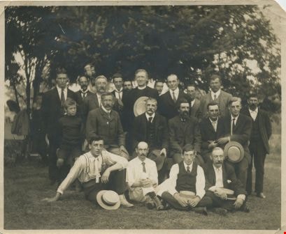
Burnaby Lake residents
https://search.heritageburnaby.ca/link/archivedescription34058
- Repository
- City of Burnaby Archives
- Date
- 1912
- Collection/Fonds
- Burnaby Historical Society fonds
- Description Level
- Item
- Physical Description
- 1 photograph : b&w ; 9.5 x 11.6 cm
- Scope and Content
- Photograph of a group of male Burnaby Lake residents posed outside near Deer Lake Drive. Identified, standing: B.R. Hill (3rd from left), Rev. D. Dunlop (6th from left), Harry Ramsay (8th from left), Louis "Edgar" Sprott (9th from left), and George Every-Clayton (10th from left). Sitting on bench…
- Repository
- City of Burnaby Archives
- Date
- 1912
- Collection/Fonds
- Burnaby Historical Society fonds
- Subseries
- Photographs subseries
- Physical Description
- 1 photograph : b&w ; 9.5 x 11.6 cm
- Description Level
- Item
- Record No.
- 003-001
- Access Restriction
- No restrictions
- Reproduction Restriction
- No known restrictions
- Accession Number
- BHS2007-04
- Scope and Content
- Photograph of a group of male Burnaby Lake residents posed outside near Deer Lake Drive. Identified, standing: B.R. Hill (3rd from left), Rev. D. Dunlop (6th from left), Harry Ramsay (8th from left), Louis "Edgar" Sprott (9th from left), and George Every-Clayton (10th from left). Sitting on bench: [first name unknown] Clayton (1st from left), Robert Pontifex (2nd from left), Mr. Clay (4th from left), and Frank Hill (6th from left). Sitting on ground: Claude Hill (1st from left) and Percy Boyer Brown (2nd from left).
- Names
- Brown, Percy Boyer
- Every-Clayton, George
- Dunlop, Rev. D.
- Hill, Bernard R.
- Hill, Frank
- Brown, Alex
- Hill, Louis Claude "Claude"
- Pontifex, Robert
- Ramsay, Harry
- Sprott, Louis "Edgar"
- Media Type
- Photograph
- Notes
- Title based on contents of photograph
- Identification key accompanying in the envelope for photo 003-001 (labeled BHS 3.1)
- Geographic Access
- Deer Lake
- Deer Lake Avenue
- Historic Neighbourhood
- Vancouver Heights (Historic Neighbourhood)
- Burnaby Lake (Historic Neighbourhood)
- Planning Study Area
- Douglas-Gilpin Area
Images