5744 Byrne Rd
https://search.heritageburnaby.ca/link/archivedescription94345
- Repository
- City of Burnaby Archives
- Date
- January 1993
- Collection/Fonds
- Grover, Elliott & Co. Ltd. fonds
- Description Level
- File
- Physical Description
- 51 photographs : col. negatives ; 35 mm
- Scope and Content
- Photographs of commercial and undeveloped properties located in the Big Bend area, including 5744 Byrne Road, Lowland Drive, and 4853 Byrne Road.
- Repository
- City of Burnaby Archives
- Date
- January 1993
- Collection/Fonds
- Grover, Elliott & Co. Ltd. fonds
- Physical Description
- 51 photographs : col. negatives ; 35 mm
- Description Level
- File
- Record No.
- 622-130
- Access Restriction
- No restrictions
- Reproduction Restriction
- No restrictions
- Accession Number
- 2017-39
- Scope and Content
- Photographs of commercial and undeveloped properties located in the Big Bend area, including 5744 Byrne Road, Lowland Drive, and 4853 Byrne Road.
- Media Type
- Photograph
- Notes
- Transcribed title
- Title transcribed from envelope photographs were originally housed in
- File no. 95-285-B
- Sticky note adhered to print of photograph 622-130-036 reads: "Lowland Drive"
- Sticky note adhered to print of photograph 622-130-039 reads: "4853 Byrne"
- Photographer identified as "L.D."
- Geographic Access
- Byrne Road
- Lowland Drive
- Street Address
- 5744 Byrne Road
- 4853 Byrne Road
- Historic Neighbourhood
- Fraser Arm (Historic Neighbourhood)
- Planning Study Area
- Big Bend Area
8980 Fraserwood Crt
https://search.heritageburnaby.ca/link/archivedescription94326
- Repository
- City of Burnaby Archives
- Date
- December 1994
- Collection/Fonds
- Grover, Elliott & Co. Ltd. fonds
- Description Level
- File
- Physical Description
- 24 photographs : col. negatives ; 35 mm
- Scope and Content
- Photographs of an undeveloped property located at 8980 Fraserwood Court. A Sutton Group real estate sign on the property advertises the site as the Fraserwood Corporate Centre with strata warehouse and office flex space. File also contains photographs of the commerical building adjacent to the si…
- Repository
- City of Burnaby Archives
- Date
- December 1994
- Collection/Fonds
- Grover, Elliott & Co. Ltd. fonds
- Physical Description
- 24 photographs : col. negatives ; 35 mm
- Description Level
- File
- Record No.
- 622-111
- Access Restriction
- No restrictions
- Reproduction Restriction
- No restrictions
- Accession Number
- 2017-39
- Scope and Content
- Photographs of an undeveloped property located at 8980 Fraserwood Court. A Sutton Group real estate sign on the property advertises the site as the Fraserwood Corporate Centre with strata warehouse and office flex space. File also contains photographs of the commerical building adjacent to the site.
- Media Type
- Photograph
- Notes
- Transcribed title
- Title transcribed from envelope photographs were originally housed in
- File no. 94-422-B
- Photographer identified as "L.D."
- Geographic Access
- Fraserwood Court
- Street Address
- 8980 Fraserwood Court
- Historic Neighbourhood
- Fraser Arm (Historic Neighbourhood)
- Planning Study Area
- Big Bend Area
![Aerial View of Chinese Market Gardens on Marine Drive, [between 1950 and 1959] (date of original), 2017 (date of duplication) thumbnail](/media/hpo/_Data/_BVM_Images/2017/2017_0040_0001_001.jpg?width=280)
Aerial View of Chinese Market Gardens on Marine Drive
https://search.heritageburnaby.ca/link/museumdescription4296
- Repository
- Burnaby Village Museum
- Date
- [between 1950 and 1959] (date of original), 2017 (date of duplication)
- Collection/Fonds
- Herbert Yee Law family fonds
- Description Level
- Item
- Physical Description
- 1 photograph (jpg) : b&w
- Scope and Content
- Photograph is an aerial view looking south over the Chinese Market Gardens along Marine Drive in the Big Bend area of Burnaby.
- Repository
- Burnaby Village Museum
- Collection/Fonds
- Herbert Yee Law family fonds
- Description Level
- Item
- Physical Description
- 1 photograph (jpg) : b&w
- Scope and Content
- Photograph is an aerial view looking south over the Chinese Market Gardens along Marine Drive in the Big Bend area of Burnaby.
- Names
- Chinese Market Gardens
- Geographic Access
- Marine Drive
- Accession Code
- BV017.40.1
- Access Restriction
- No restrictions
- Reproduction Restriction
- May be restricted by third party rights
- Date
- [between 1950 and 1959] (date of original), 2017 (date of duplication)
- Media Type
- Photograph
- Historic Neighbourhood
- Fraser Arm (Historic Neighbourhood)
- Planning Study Area
- Big Bend Area
- Scan Resolution
- 600
- Scan Date
- 11/19/2017
- Scale
- 100
- Notes
- Title based on contents of photograph.
Images
![Aerial View of Chinese Market Gardens on Marine Drive, [between 1950 and 1959] (date of original), 2017 (date of duplication) thumbnail](/media/hpo/_Data/_BVM_Images/2017/2017_0040_0001_001.jpg)

Chinese Market Gardens
https://search.heritageburnaby.ca/link/archivedescription70542
- Repository
- City of Burnaby Archives
- Date
- 1949
- Collection/Fonds
- Gail Yip fonds
- Description Level
- Item
- Physical Description
- 1 photograph (jpeg) : b&w
- Scope and Content
- Photograph is an aerial view looking south over the Chinese Market Gardens along Marine Drive. The farm on the south side of Marine Drive, second from the east, is 4930 Marine Drive.
- Repository
- City of Burnaby Archives
- Date
- 1949
- Collection/Fonds
- Gail Yip fonds
- Physical Description
- 1 photograph (jpeg) : b&w
- Description Level
- Item
- Record No.
- 529-001
- Access Restriction
- No restrictions
- Reproduction Restriction
- Reproduce for fair dealing purposes only
- Accession Number
- 2012-04
- Scope and Content
- Photograph is an aerial view looking south over the Chinese Market Gardens along Marine Drive. The farm on the south side of Marine Drive, second from the east, is 4930 Marine Drive.
- Subjects
- Agriculture - Crops
- Agriculture - Farms
- Names
- Chinese Market Gardens
- Media Type
- Photograph
- Geographic Access
- Marine Drive
- Street Address
- 4930 Marine Drive
- Historic Neighbourhood
- Fraser Arm (Historic Neighbourhood)
- Planning Study Area
- Big Bend Area
Images


Marine Way and Willard Street
https://search.heritageburnaby.ca/link/archivedescription79912
- Repository
- City of Burnaby Archives
- Date
- November, 1976
- Collection/Fonds
- Burnaby Public Library Contemporary Visual Archive Project
- Description Level
- Item
- Physical Description
- 1 photograph : b&w ; 11 x 16 cm mounted on cardboard
- Scope and Content
- Photograph shows a collection of signboards on the corner of Marine Way and Willard Street.
- Repository
- City of Burnaby Archives
- Date
- November, 1976
- Collection/Fonds
- Burnaby Public Library Contemporary Visual Archive Project
- Physical Description
- 1 photograph : b&w ; 11 x 16 cm mounted on cardboard
- Description Level
- Item
- Record No.
- 556-494
- Access Restriction
- No restrictions
- Reproduction Restriction
- Reproduce for fair dealing purposes only
- Accession Number
- 2013-13
- Scope and Content
- Photograph shows a collection of signboards on the corner of Marine Way and Willard Street.
- Media Type
- Photograph
- Photographer
- Campbell, Peg
- Notes
- Scope note taken directly from BPL photograph description.
- 1 b&w copy negative : 10 x 12.5 cm accompanying
- Geographic Access
- Marine Way
- Willard Street
- Historic Neighbourhood
- Fraser Arm (Historic Neighbourhood)
- Planning Study Area
- Big Bend Area
Images

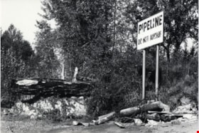
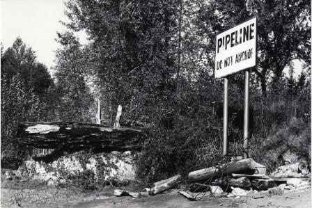
Pipeline Sign
https://search.heritageburnaby.ca/link/archivedescription79925
- Repository
- City of Burnaby Archives
- Date
- October 20, 1976
- Collection/Fonds
- Burnaby Public Library Contemporary Visual Archive Project
- Description Level
- Item
- Physical Description
- 1 photograph : b&w ; 11 x 16 cm mounted on cardboard
- Scope and Content
- Photograph shows a sign on the bank of the Fraser River near the end of Byrne Road, warning boaters not to anchor in the area because of a pipeline.
- Repository
- City of Burnaby Archives
- Date
- October 20, 1976
- Collection/Fonds
- Burnaby Public Library Contemporary Visual Archive Project
- Physical Description
- 1 photograph : b&w ; 11 x 16 cm mounted on cardboard
- Description Level
- Item
- Record No.
- 556-496
- Access Restriction
- No restrictions
- Reproduction Restriction
- Reproduce for fair dealing purposes only
- Accession Number
- 2013-13
- Scope and Content
- Photograph shows a sign on the bank of the Fraser River near the end of Byrne Road, warning boaters not to anchor in the area because of a pipeline.
- Media Type
- Photograph
- Photographer
- Ross, Martha
- Notes
- Scope note taken directly from BPL photograph description.
- 1 b&w copy negative : 10 x 12.5 cm accompanying
- Geographic Access
- Fraser River
- Historic Neighbourhood
- Fraser Arm (Historic Neighbourhood)
- Planning Study Area
- Big Bend Area
Images
![Planning Map of Chinese Market Gardens on Marine Drive, [between 1950 and 1959] (date of original), 2017 (date of duplication) thumbnail](/media/hpo/_Data/_BVM_Images/2017/2017_0040_0002_001.jpg?width=280)
Planning Map of Chinese Market Gardens on Marine Drive
https://search.heritageburnaby.ca/link/museumdescription4297
- Repository
- Burnaby Village Museum
- Date
- [between 1950 and 1959] (date of original), 2017 (date of duplication)
- Collection/Fonds
- Herbert Yee Law family fonds
- Description Level
- Item
- Physical Description
- 1 photograph (tiff) : col. ; 300 dpi
- Scope and Content
- Scanned copy of a survey plan of district lots 163, 162, 157, 158, and 165, near the Chinese Market Gardens along Marine Drive.
- Repository
- Burnaby Village Museum
- Collection/Fonds
- Herbert Yee Law family fonds
- Description Level
- Item
- Physical Description
- 1 photograph (tiff) : col. ; 300 dpi
- Scope and Content
- Scanned copy of a survey plan of district lots 163, 162, 157, 158, and 165, near the Chinese Market Gardens along Marine Drive.
- History
- Survey plan of district lots 163, 162, 157, 158, and 165, which is primarily the area farmed by Chinese and Chinese-Canadian market gardeners around Marine Drive between Royal Oak and Mandeville (present-day Nelson). Two Chinese/Chinese Canadian land owners can be seen on the map: N.G. Wah Sing (or Ng Wah Sing) and Yee Law (or Herbert Law).
- Geographic Access
- Marine Drive
- Accession Code
- BV017.40.2
- Access Restriction
- No restrictions
- Reproduction Restriction
- No known restrictions
- Date
- [between 1950 and 1959] (date of original), 2017 (date of duplication)
- Media Type
- Cartographic Material
- Historic Neighbourhood
- Fraser Arm (Historic Neighbourhood)
- Planning Study Area
- Big Bend Area
- Scan Resolution
- 300
- Scan Date
- 11/19/2017
- Scale
- 100
- Notes
- Title based on contents of copy scan of map
- Herbert Yee Law was donor's father and this map may have originally been his copy of the city planning/engineering documents.
Images
![Planning Map of Chinese Market Gardens on Marine Drive, [between 1950 and 1959] (date of original), 2017 (date of duplication) thumbnail](/media/hpo/_Data/_BVM_Images/2017/2017_0040_0002_001.jpg)
![Robert Nasato at Marine/10th Ave. Connector, [2000] thumbnail](/media/hpo/_Data/_Archives_Images/_Unrestricted/535/535-3069.jpg?width=280)
Robert Nasato at Marine/10th Ave. Connector
https://search.heritageburnaby.ca/link/archivedescription97943
- Repository
- City of Burnaby Archives
- Date
- [2000]
- Collection/Fonds
- Burnaby NewsLeader photograph collection
- Description Level
- Item
- Physical Description
- 1 photograph (tiff) : col.
- Scope and Content
- Photograph of Robert Nasato, the president of the West End Residents' Association, posing net to sign advertising the plans for the Marine/10th Ave. Connector.
- Repository
- City of Burnaby Archives
- Date
- [2000]
- Collection/Fonds
- Burnaby NewsLeader photograph collection
- Physical Description
- 1 photograph (tiff) : col.
- Description Level
- Item
- Record No.
- 535-3069
- Access Restriction
- No restrictions
- Reproduction Restriction
- No restrictions
- Accession Number
- 2018-12
- Scope and Content
- Photograph of Robert Nasato, the president of the West End Residents' Association, posing net to sign advertising the plans for the Marine/10th Ave. Connector.
- Media Type
- Photograph
- Photographer
- Bartel, Mario
- Notes
- Title based on caption
- Collected by editorial for use in a January 2000 issue of the Burnaby NewsLeader
- Caption from metadata: "Robert Nasato, the president of the West End Residents' Association, isn't happy about the proposed Marine/10th Ave. connector, to be built through his neighborhood."
- Geographic Access
- 10th Avenue
- Marine Drive
- Historic Neighbourhood
- Fraser Arm (Historic Neighbourhood)
- Planning Study Area
- Stride Hill Area
Images
![Robert Nasato at Marine/10th Ave. Connector, [2000] thumbnail](/media/hpo/_Data/_Archives_Images/_Unrestricted/535/535-3069.jpg)