Narrow Results By
Decade
- 2020s 11
- 2010s 4
- 2000s 106
- 1990s 88
- 1980s 22
- 1970s 305
- 1960s
- 1950s
- 1940s 60
- 1930s 53
- 1920s 88
- 1910s 65
- 1900s 24
- 1890s 10
- 1880s 2
- 1870s 1
- 1860s 2
- 1850s 1
- 1840s 1
- 1830s 1
- 1820s 1
- 1810s 1
- 1800s 1
- 1790s 1
- 1780s 1
- 1770s 1
- 1760s 1
- 1750s
- 1740s 1
- 1730s 1
- 1720s 1
- 1710s 1
- 1700s 1
- 1690s 1
- 1680s 1
- 1670s 1
- 1660s 1
- 1650s 1
- 1640s 1
- 1630s 1
- 1620s 1
- 1610s 1
- 1600s 1
Subject
- Advertising Medium - Signs and Signboards 1
- Aerial Photographs 4
- Agricultural Tools and Equipment 2
- Agricultural Tools and Equipment - Plows 3
- Agriculture - Farms 6
- Animals - Goats 1
- Animals - Horses 1
- Animals - Sheep 1
- Arts - Paintings 4
- Buildings 1
- Buildings - Civic 1
- Buildings - Civic - Art Galleries 17

20th century typewriting : complete course
https://search.heritageburnaby.ca/link/museumlibrary5012
- Repository
- Burnaby Village Museum
- Collection
- Special Collection
- Material Type
- Book
- Accession Code
- BV007.2.1
- Call Number
- 652.3 LES
- Edition
- 6th ed.
- Place of Publication
- Cincinnati
- Publisher
- South-Western Publishing Co.
- Publication Date
- c1952
- Physical Description
- 340 p. : ill. : 20 x 28 cm.
- Library Subject (LOC)
- Typewriting
- Subjects
- Documentary Artifacts - Books
- Historic Neighbourhood
- Edmonds (Historic Neighbourhood)
- Burnaby Lake (Historic Neighbourhood)
- Planning Study Area
- Kingsway-Beresford Area
- Douglas-Gilpin Area
- Geographic Access
- Canada Way
- Southoaks Crescent
- Street Address
- 4939 Canada Way
- 6650 Southoaks Crescent
- Object History
- Was used by Burnaby resident Barbara Copan when she taught typing at Burnaby Central circa 1963-65. It may have originally belonged to Barbara's mother who also taught typing at Burnaby South High School circa 1957 to 1965. She mainly taught typing in night school.
- Notes
- Authors' given name and date as follows: Lessenberry, D.D. (David Daniel), 1896- Crawford, T. James (Thomas James)
Images


![4006 Douglas Road, [1960] (date of original), copied 1991 thumbnail](/media/hpo/_Data/_Archives_Images/_Unrestricted/370/370-516.jpg?width=280)
4006 Douglas Road
https://search.heritageburnaby.ca/link/archivedescription37928
- Repository
- City of Burnaby Archives
- Date
- [1960] (date of original), copied 1991
- Collection/Fonds
- Burnaby Historical Society fonds
- Description Level
- Item
- Physical Description
- 1 photograph : b&w ; 3.1 x 3.1 cm print on contact sheet 20.7 x 26.5 cm
- Scope and Content
- Photograph of 4006 Douglas Road (old numbering) in the snow. The house was located near Douglas Road and Gilpin Street.
- Repository
- City of Burnaby Archives
- Date
- [1960] (date of original), copied 1991
- Collection/Fonds
- Burnaby Historical Society fonds
- Subseries
- Burnaby Image Bank subseries
- Physical Description
- 1 photograph : b&w ; 3.1 x 3.1 cm print on contact sheet 20.7 x 26.5 cm
- Description Level
- Item
- Record No.
- 370-516
- Access Restriction
- No restrictions
- Reproduction Restriction
- No restrictions
- Accession Number
- BHS1999-03
- Scope and Content
- Photograph of 4006 Douglas Road (old numbering) in the snow. The house was located near Douglas Road and Gilpin Street.
- Subjects
- Natural Phenomena - Snow
- Media Type
- Photograph
- Notes
- Title based on contents of photograph
- 1 b&w copy negative accompanying
- Negative has a pink cast
- Geographic Access
- Gilpin Street
- Historic Neighbourhood
- Burnaby Lake (Historic Neighbourhood)
- Planning Study Area
- Douglas-Gilpin Area
Images
![4006 Douglas Road, [1960] (date of original), copied 1991 thumbnail](/media/hpo/_Data/_Archives_Images/_Unrestricted/370/370-516.jpg)
Aerial photograph of Burnaby
https://search.heritageburnaby.ca/link/archivedescription84903
- Repository
- City of Burnaby Archives
- Date
- 1963
- Collection/Fonds
- Allan Amundsen collection
- Description Level
- Item
- Physical Description
- 1 photograph : b&w ; 22.5 x 22.5 cm
- Scope and Content
- Aerial photograph of Burnaby with the Trans Canada Highway running through and the Forest Lawn Cemetery to the south.
- Repository
- City of Burnaby Archives
- Date
- 1963
- Collection/Fonds
- Allan Amundsen collection
- Physical Description
- 1 photograph : b&w ; 22.5 x 22.5 cm
- Description Level
- Item
- Record No.
- 561-024
- Access Restriction
- In Archives only
- Reproduction Restriction
- No reproduction permitted
- Accession Number
- 2014-08
- Scope and Content
- Aerial photograph of Burnaby with the Trans Canada Highway running through and the Forest Lawn Cemetery to the south.
- Subjects
- Aerial Photographs
- Media Type
- Photograph
- Photographer
- Province of British Columbia
- Notes
- Title based on contents of photograph
- This photo is indentified as BC5062:27 and connects with B.C. air photograph BC5061:26 to the east
- Historic Neighbourhood
- Burnaby Lake (Historic Neighbourhood)
- Planning Study Area
- Douglas-Gilpin Area
- Ardingley-Sprott Area
- Dawson-Delta Area
Aerial photograph of Burnaby
https://search.heritageburnaby.ca/link/archivedescription84907
- Repository
- City of Burnaby Archives
- Date
- 1963
- Collection/Fonds
- Allan Amundsen collection
- Description Level
- Item
- Physical Description
- 1 photograph : b&w ; 22.5 x 22.5 cm
- Scope and Content
- Aerial photograph of Burnaby with the Trans Canada Highway running from through and Burnaby Lake in the south east corner.
- Repository
- City of Burnaby Archives
- Date
- 1963
- Collection/Fonds
- Allan Amundsen collection
- Physical Description
- 1 photograph : b&w ; 22.5 x 22.5 cm
- Description Level
- Item
- Record No.
- 561-025
- Access Restriction
- In Archives only
- Reproduction Restriction
- No reproduction permitted
- Accession Number
- 2014-08
- Scope and Content
- Aerial photograph of Burnaby with the Trans Canada Highway running from through and Burnaby Lake in the south east corner.
- Subjects
- Aerial Photographs
- Media Type
- Photograph
- Photographer
- Province of British Columbia
- Notes
- Title based on contents of photograph
- This photo is indentified as BC5062:26 and connects with B.C. air photograph BC5062:27 to the west and B.C. air photograph BC5062:25 to the east
- Historic Neighbourhood
- Burnaby Lake (Historic Neighbourhood)
- Planning Study Area
- Douglas-Gilpin Area
- Ardingley-Sprott Area
- Burnaby Lake Area
Aerial photograph of Burnaby Lake Area
https://search.heritageburnaby.ca/link/archivedescription84908
- Repository
- City of Burnaby Archives
- Date
- 1963
- Collection/Fonds
- Allan Amundsen collection
- Description Level
- Item
- Physical Description
- 1 photograph : b&w ; 22.5 x 22.5 cm
- Scope and Content
- Aerial photograph of Burnaby with Lougheed Highway in the north west corner, the Trans Canada Highway in the south east corner and Burnaby Lake appearing from the west.
- Repository
- City of Burnaby Archives
- Date
- 1963
- Collection/Fonds
- Allan Amundsen collection
- Physical Description
- 1 photograph : b&w ; 22.5 x 22.5 cm
- Description Level
- Item
- Record No.
- 561-026
- Access Restriction
- In Archives only
- Reproduction Restriction
- No reproduction permitted
- Accession Number
- 2014-08
- Scope and Content
- Aerial photograph of Burnaby with Lougheed Highway in the north west corner, the Trans Canada Highway in the south east corner and Burnaby Lake appearing from the west.
- Subjects
- Aerial Photographs
- Media Type
- Photograph
- Photographer
- Province of British Columbia
- Notes
- Title based on contents of photograph
- This photo is indentified as BC5062:25 and connects with B.C. air photograph BC5062:26 to the west and B.C. air photograph BC5062:24 to the east
- Historic Neighbourhood
- Burnaby Lake (Historic Neighbourhood)
- Lozells (Historic Neighbourhood)
- Planning Study Area
- Douglas-Gilpin Area
- Sperling-Broadway Area
- Government Road Area
- Burnaby Lake Area
Aerial photograph of Burnaby Lake Area
https://search.heritageburnaby.ca/link/archivedescription84909
- Repository
- City of Burnaby Archives
- Date
- 1963
- Collection/Fonds
- Allan Amundsen collection
- Description Level
- Item
- Physical Description
- 1 photograph : b&w ; 22.5 x 22.5 cm
- Scope and Content
- Aerial photograph of Burnaby with Lougheed Highway to the north and Burnaby Lake to the south.
- Repository
- City of Burnaby Archives
- Date
- 1963
- Collection/Fonds
- Allan Amundsen collection
- Physical Description
- 1 photograph : b&w ; 22.5 x 22.5 cm
- Description Level
- Item
- Record No.
- 561-027
- Access Restriction
- In Archives only
- Reproduction Restriction
- No reproduction permitted
- Accession Number
- 2014-08
- Scope and Content
- Aerial photograph of Burnaby with Lougheed Highway to the north and Burnaby Lake to the south.
- Subjects
- Aerial Photographs
- Media Type
- Photograph
- Photographer
- Province of British Columbia
- Notes
- Title based on contents of photograph
- This photo is indentified as BC5062:24 and connects with B.C. air photograph BC5062:25 to the west and B.C. air photograph BC5062:23 to the east
- Historic Neighbourhood
- Burnaby Lake (Historic Neighbourhood)
- Lozells (Historic Neighbourhood)
- Planning Study Area
- Douglas-Gilpin Area
- Sperling-Broadway Area
- Government Road Area
- Burnaby Lake Area
Anderson family
https://search.heritageburnaby.ca/link/archivedescription37440
- Repository
- City of Burnaby Archives
- Date
- 1958 (date of original), copied 1991
- Collection/Fonds
- Burnaby Historical Society fonds
- Description Level
- Item
- Physical Description
- 1 photograph : b&w ; 4.2 x 3.5 cm print on contact sheet 20.2 x 25.3 cm
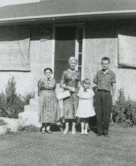
- Scope and Content
- Photograph of the Anderson family in front of the Anderson family home at 3908 Norland Avenue (previously numbered 4437 Norland Avenue). Left to right: Mrs. Anderson (grandmother), Madelaine Anderson (mother), Janet Anderson (daughter), and Cliff Anderson (son).
- Repository
- City of Burnaby Archives
- Date
- 1958 (date of original), copied 1991
- Collection/Fonds
- Burnaby Historical Society fonds
- Subseries
- Burnaby Image Bank subseries
- Physical Description
- 1 photograph : b&w ; 4.2 x 3.5 cm print on contact sheet 20.2 x 25.3 cm
- Description Level
- Item
- Record No.
- 370-028
- Access Restriction
- No restrictions
- Reproduction Restriction
- No restrictions
- Accession Number
- BHS1999-03
- Scope and Content
- Photograph of the Anderson family in front of the Anderson family home at 3908 Norland Avenue (previously numbered 4437 Norland Avenue). Left to right: Mrs. Anderson (grandmother), Madelaine Anderson (mother), Janet Anderson (daughter), and Cliff Anderson (son).
- Media Type
- Photograph
- Notes
- Title based on contents of photograph
- 1 b&w copy negative accompanying
- Geographic Access
- Norland Avenue
- Street Address
- 3908 Norland Avenue
- Historic Neighbourhood
- Burnaby Lake (Historic Neighbourhood)
- Planning Study Area
- Douglas-Gilpin Area
Images

Anderson family
https://search.heritageburnaby.ca/link/archivedescription37443
- Repository
- City of Burnaby Archives
- Date
- 1959 (date of original), copied 1991
- Collection/Fonds
- Burnaby Historical Society fonds
- Description Level
- Item
- Physical Description
- 1 photograph : b&w ; 3.9 x 4.3 cm print on contact sheet 20.2 x 25.3 cm
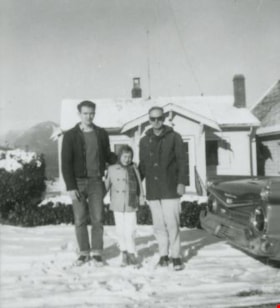
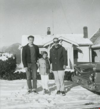
- Scope and Content
- Photograph of the Anderson family in front of their home at 3908 Norland Avenue (originally numbered 4437 Norland Avenue) after a snowfall. Left to right: Cliff Anderson (son), Janet Anderson (daughter), and Robert "Bob" Anderson (father). To the side is a 1959 Galaxie car.
- Repository
- City of Burnaby Archives
- Date
- 1959 (date of original), copied 1991
- Collection/Fonds
- Burnaby Historical Society fonds
- Subseries
- Burnaby Image Bank subseries
- Physical Description
- 1 photograph : b&w ; 3.9 x 4.3 cm print on contact sheet 20.2 x 25.3 cm
- Description Level
- Item
- Record No.
- 370-031
- Access Restriction
- No restrictions
- Reproduction Restriction
- No restrictions
- Accession Number
- BHS1999-03
- Scope and Content
- Photograph of the Anderson family in front of their home at 3908 Norland Avenue (originally numbered 4437 Norland Avenue) after a snowfall. Left to right: Cliff Anderson (son), Janet Anderson (daughter), and Robert "Bob" Anderson (father). To the side is a 1959 Galaxie car.
- Media Type
- Photograph
- Notes
- Title based on contents of photograph
- 1 b&w copy negative accompanying
- Geographic Access
- Norland Avenue
- Street Address
- 3908 Norland Avenue
- Historic Neighbourhood
- Burnaby Lake (Historic Neighbourhood)
- Planning Study Area
- Douglas-Gilpin Area
Images

Anderson family
https://search.heritageburnaby.ca/link/archivedescription37447
- Repository
- City of Burnaby Archives
- Date
- 1961 (date of original), copied 1991
- Collection/Fonds
- Burnaby Historical Society fonds
- Description Level
- Item
- Physical Description
- 1 photograph : b&w ; 4.1 x 3.5 cm print on contact sheet 20.2 x 25.4 cm
- Scope and Content
- Photograph of the Anderson family at the back of their home at 3908 Norland Avenue (previously numbered 4437 Norland Avenue). Left to right: Cliff Anderson (son), Janet Anderson (daughter), and Robert "Bob" Anderson (father). The background includes the area of the Trans Canada Highway before it w…
- Repository
- City of Burnaby Archives
- Date
- 1961 (date of original), copied 1991
- Collection/Fonds
- Burnaby Historical Society fonds
- Subseries
- Burnaby Image Bank subseries
- Physical Description
- 1 photograph : b&w ; 4.1 x 3.5 cm print on contact sheet 20.2 x 25.4 cm
- Description Level
- Item
- Record No.
- 370-035
- Access Restriction
- No restrictions
- Reproduction Restriction
- No restrictions
- Accession Number
- BHS1999-03
- Scope and Content
- Photograph of the Anderson family at the back of their home at 3908 Norland Avenue (previously numbered 4437 Norland Avenue). Left to right: Cliff Anderson (son), Janet Anderson (daughter), and Robert "Bob" Anderson (father). The background includes the area of the Trans Canada Highway before it was built.
- Media Type
- Photograph
- Notes
- Title based on contents of photograph
- 1 b&w copy negative accompanying
- Geographic Access
- Norland Avenue
- Street Address
- 3908 Norland Avenue
- Historic Neighbourhood
- Burnaby Lake (Historic Neighbourhood)
- Planning Study Area
- Douglas-Gilpin Area
Images


Anderson family home
https://search.heritageburnaby.ca/link/archivedescription37448
- Repository
- City of Burnaby Archives
- Date
- 1962 (date of original), copied 1991
- Collection/Fonds
- Burnaby Historical Society fonds
- Description Level
- Item
- Physical Description
- 1 photograph : b&w ; 4.1 x 3.8 cm print on contact sheet 20.2 x 25.4 cm
- Scope and Content
- Photograph of the front of the Anderson family home at 3908 Norland Avenue (previously numbered 4437 Norland Avenue) in the snow.
- Repository
- City of Burnaby Archives
- Date
- 1962 (date of original), copied 1991
- Collection/Fonds
- Burnaby Historical Society fonds
- Subseries
- Burnaby Image Bank subseries
- Physical Description
- 1 photograph : b&w ; 4.1 x 3.8 cm print on contact sheet 20.2 x 25.4 cm
- Description Level
- Item
- Record No.
- 370-036
- Access Restriction
- No restrictions
- Reproduction Restriction
- No restrictions
- Accession Number
- BHS1999-03
- Scope and Content
- Photograph of the front of the Anderson family home at 3908 Norland Avenue (previously numbered 4437 Norland Avenue) in the snow.
- Media Type
- Photograph
- Notes
- Title based on contents of photograph
- 1 b&w copy negative accompanying
- Geographic Access
- Norland Avenue
- Street Address
- 3908 Norland Avenue
- Historic Neighbourhood
- Burnaby Lake (Historic Neighbourhood)
- Planning Study Area
- Douglas-Gilpin Area
Images


The Benedictines of Westminster Priory
https://search.heritageburnaby.ca/link/archivedescription38167
- Repository
- City of Burnaby Archives
- Date
- 1951 (date of original), copied 1991
- Collection/Fonds
- Burnaby Historical Society fonds
- Description Level
- Item
- Physical Description
- 1 photograph : b&w ; 3.3 x 5.3 cm print on contact sheet 20.1 x 26.3 cm
- Scope and Content
- Photograph of an original photographic postcard of the Benedictines of Westminster Priory at Ceperley House which was funded by the Catholic Diocese beginning in 1939. There is a postmark from Merritt, British Columbia, at the top right corner.
- Repository
- City of Burnaby Archives
- Date
- 1951 (date of original), copied 1991
- Collection/Fonds
- Burnaby Historical Society fonds
- Subseries
- Burnaby Image Bank subseries
- Physical Description
- 1 photograph : b&w ; 3.3 x 5.3 cm print on contact sheet 20.1 x 26.3 cm
- Description Level
- Item
- Record No.
- 370-754
- Access Restriction
- No restrictions
- Reproduction Restriction
- No restrictions
- Accession Number
- BHS1999-03
- Scope and Content
- Photograph of an original photographic postcard of the Benedictines of Westminster Priory at Ceperley House which was funded by the Catholic Diocese beginning in 1939. There is a postmark from Merritt, British Columbia, at the top right corner.
- Subjects
- Buildings - Religious
- Buildings - Heritage
- Occupations - Clergy
- Documentary Artifacts - Postcards
- Names
- Westminster Priory
- Media Type
- Photograph
- Notes
- 1 b&w copy negative accompanying
- Negative has a pink cast
- Annotation at bottom of photograph reads, "The Benedictines of Westminster Priory, Vancouver, BC"
- Geographic Access
- Deer Lake Avenue
- Street Address
- 6344 Deer Lake Avenue
- Historic Neighbourhood
- Burnaby Lake (Historic Neighbourhood)
- Planning Study Area
- Douglas-Gilpin Area
Images

Bob and Janet Anderson
https://search.heritageburnaby.ca/link/archivedescription37450
- Repository
- City of Burnaby Archives
- Date
- 1962 (date of original), copied 1991
- Collection/Fonds
- Burnaby Historical Society fonds
- Description Level
- Item
- Physical Description
- 1 photograph : b&w ; 4.3 x 4.0 cm print on contact sheet 20.2 x 25.4 cm
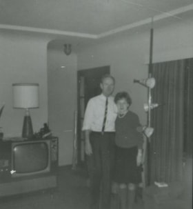
- Scope and Content
- Photograph of father and daughter Bob and Janet Anderson standing in the living room of 3908 Norland Avenue (previously numbered 4437 Norland Avenue).
- Repository
- City of Burnaby Archives
- Date
- 1962 (date of original), copied 1991
- Collection/Fonds
- Burnaby Historical Society fonds
- Subseries
- Burnaby Image Bank subseries
- Physical Description
- 1 photograph : b&w ; 4.3 x 4.0 cm print on contact sheet 20.2 x 25.4 cm
- Description Level
- Item
- Record No.
- 370-038
- Access Restriction
- No restrictions
- Reproduction Restriction
- No restrictions
- Accession Number
- BHS1999-03
- Scope and Content
- Photograph of father and daughter Bob and Janet Anderson standing in the living room of 3908 Norland Avenue (previously numbered 4437 Norland Avenue).
- Subjects
- Furniture
- Media Type
- Photograph
- Notes
- Title based on contents of photograph
- 1 b&w copy negative accompanying
- Copied from col. photograph
- Geographic Access
- Norland Avenue
- Street Address
- 3908 Norland Avenue
- Historic Neighbourhood
- Burnaby Lake (Historic Neighbourhood)
- Planning Study Area
- Douglas-Gilpin Area
Images


Bob Hutton at Municipal Hall
https://search.heritageburnaby.ca/link/archivedescription37294
- Repository
- City of Burnaby Archives
- Date
- 1958
- Collection/Fonds
- Burnaby Historical Society fonds
- Description Level
- Item
- Physical Description
- 1 photograph : b&w ; 9 x 9 cm
- Scope and Content
- Photograph of a man identified as Bob Hutton outside Burnaby Municipal Hall. Two other men are visible in the picture, but neither is identified.
- Repository
- City of Burnaby Archives
- Date
- 1958
- Collection/Fonds
- Burnaby Historical Society fonds
- Subseries
- Norah Code subseries
- Physical Description
- 1 photograph : b&w ; 9 x 9 cm
- Description Level
- Item
- Record No.
- 345-015
- Access Restriction
- No restrictions
- Reproduction Restriction
- Reproduce for fair dealing purposes only
- Accession Number
- BHS1997-05
- Scope and Content
- Photograph of a man identified as Bob Hutton outside Burnaby Municipal Hall. Two other men are visible in the picture, but neither is identified.
- Subjects
- Buildings - Civic - City Halls
- Names
- Hutton, Bob
- Burnaby City Hall
- Media Type
- Photograph
- Photographer
- Code, Norah
- Notes
- Title based on contents of photograph.
- Photographs in this collection were taken and compiled by Norah Code, former editor of the "Burnaby Courier" newspaper during the course of her work for the newspaper.
- Geographic Access
- Canada Way
- Street Address
- 4949 Canada Way
- Historic Neighbourhood
- Burnaby Lake (Historic Neighbourhood)
- Planning Study Area
- Douglas-Gilpin Area
Images


Bob Hutton, outside Burnaby Municipal Hall
https://search.heritageburnaby.ca/link/archivedescription37300
- Repository
- City of Burnaby Archives
- Date
- 1958
- Collection/Fonds
- Burnaby Historical Society fonds
- Description Level
- Item
- Physical Description
- 1 photograph : b&w ; 9.5 x 14.5 cm
- Scope and Content
- Photograph of two men and one woman standing outside Burnaby Municipal Hall reading from a proclamation and addressing a fourth man who is seen to the far right holding a microphone. The microphone bears the call letters CKNW and the man holding it has been identified as Bob Hutton.
- Repository
- City of Burnaby Archives
- Date
- 1958
- Collection/Fonds
- Burnaby Historical Society fonds
- Subseries
- Norah Code subseries
- Physical Description
- 1 photograph : b&w ; 9.5 x 14.5 cm
- Description Level
- Item
- Record No.
- 345-021
- Access Restriction
- No restrictions
- Reproduction Restriction
- Reproduce for fair dealing purposes only
- Accession Number
- BHS1997-05
- Scope and Content
- Photograph of two men and one woman standing outside Burnaby Municipal Hall reading from a proclamation and addressing a fourth man who is seen to the far right holding a microphone. The microphone bears the call letters CKNW and the man holding it has been identified as Bob Hutton.
- Subjects
- Buildings - Civic - City Halls
- Names
- Hutton, Bob
- Burnaby City Hall
- Media Type
- Photograph
- Photographer
- Code, Norah
- Notes
- Photographs in this collection were taken and compiled by Norah Code, former editor of the "Burnaby Courier" newspaper during the course of her work for the newspaper.
- Geographic Access
- Canada Way
- Street Address
- 4949 Canada Way
- Historic Neighbourhood
- Burnaby Lake (Historic Neighbourhood)
- Planning Study Area
- Douglas-Gilpin Area
Images

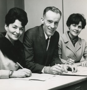
Bob Prittie, Caroline Prior and Del Carrell
https://search.heritageburnaby.ca/link/archivedescription46022
- Repository
- City of Burnaby Archives
- Date
- November 1968
- Collection/Fonds
- Columbian Newspaper collection
- Description Level
- Item
- Physical Description
- 1 photograph : b&w ; 14 x 14 cm
- Scope and Content
- Photograph of Burnaby Citizen's Association candidates; school board trustee Caroline Prior, Mayor Bob Prittie, and aldermanic candidate Del Carrell filing civic election nomination papers at City Hall.
- Repository
- City of Burnaby Archives
- Date
- November 1968
- Collection/Fonds
- Columbian Newspaper collection
- Physical Description
- 1 photograph : b&w ; 14 x 14 cm
- Description Level
- Item
- Record No.
- 480-910
- Access Restriction
- No restrictions
- Reproduction Restriction
- Reproduce for fair dealing purposes only
- Accession Number
- 2003-02
- Scope and Content
- Photograph of Burnaby Citizen's Association candidates; school board trustee Caroline Prior, Mayor Bob Prittie, and aldermanic candidate Del Carrell filing civic election nomination papers at City Hall.
- Names
- Prittie, Robert W. "Bob"
- Prior, Caroline
- Carrell, Del
- Burnaby Citizens Association
- Burnaby School Trustees
- Media Type
- Photograph
- Notes
- Title based on contents of photograph
- Newspaper clipping attached to verso of photograph reads: "Filing civic election nomination papers at municipal hall are BCA candidates Mrs. Caroline Prior, incumbent school board trustee; mayoralty [sic] candidate Robert Prittie, and aldermanic candidate Mrs. Del Carrell."
- Geographic Access
- Canada Way
- Street Address
- 4949 Canada Way
- Historic Neighbourhood
- Burnaby Lake (Historic Neighbourhood)
- Planning Study Area
- Douglas-Gilpin Area
Images


British Columbia Institute of Technology (BCIT)
https://search.heritageburnaby.ca/link/landmark806
- Repository
- Burnaby Heritage Planning
- Geographic Access
- Willingdon Avenue
- Associated Dates
- 1960
- Heritage Value
- The BC Vocational School was established in 1960 at Willingdon and Canada Way. By 1964, the British Columbia Insitute of Technology had opened and had 498 students enrolled. In the 1970s, the BC Vocational School had been renamed the Pacific Vocational Institute and in 1986 the two institutions merged. The school is a public post-secondary institution that is governed by a Board of Governors, under the authority of the Ministry of Advanced Education, Training and Technology. By 2004, the annual enrolment of part-time and full-time students reached 48,000.
- Planning Study Area
- Douglas-Gilpin Area
- Street Address
- 3700 Willingdon Avenue
- Street View URL
- Google Maps Street View
Images

![British Columbia Institute of Technology campus, [1964] published February 5, 1964 thumbnail](/media/hpo/_Data/_Archives_Images/_Unrestricted/480/480-332.jpg?width=280)
British Columbia Institute of Technology campus
https://search.heritageburnaby.ca/link/archivedescription45437
- Repository
- City of Burnaby Archives
- Date
- [1964] published February 5, 1964
- Collection/Fonds
- Columbian Newspaper collection
- Description Level
- Item
- Physical Description
- 1 photograph : b&w ; 7.5 x 23 cm
- Scope and Content
- Photograph of the British Columbia Institute of Technology campus.
- Repository
- City of Burnaby Archives
- Date
- [1964] published February 5, 1964
- Collection/Fonds
- Columbian Newspaper collection
- Physical Description
- 1 photograph : b&w ; 7.5 x 23 cm
- Description Level
- Item
- Record No.
- 480-332
- Access Restriction
- No restrictions
- Reproduction Restriction
- No restrictions
- Accession Number
- 2003-02
- Scope and Content
- Photograph of the British Columbia Institute of Technology campus.
- Media Type
- Photograph
- Photographer
- King, Basil
- Notes
- Title based on contents of photograph
- Geographic Access
- Willingdon Avenue
- Street Address
- 3700 Willingdon Avenue
- Historic Neighbourhood
- Burnaby Lake (Historic Neighbourhood)
- Planning Study Area
- Douglas-Gilpin Area
Images
![British Columbia Institute of Technology campus, [1964] published February 5, 1964 thumbnail](/media/hpo/_Data/_Archives_Images/_Unrestricted/480/480-332.jpg)
![Bruce Northorp and Robert Prittie, [between 1969 and 1973] thumbnail](/media/hpo/_Data/_Archives_Images/_Unrestricted/480/480-1098.jpg?width=280)
Bruce Northorp and Robert Prittie
https://search.heritageburnaby.ca/link/archivedescription46210
- Repository
- City of Burnaby Archives
- Date
- [between 1969 and 1973]
- Collection/Fonds
- Columbian Newspaper collection
- Description Level
- Item
- Physical Description
- 1 photograph : b&w ; 19.5 x 24.5 cm
- Scope and Content
- Photograph of Royal Canadian Mounted Police staff-sergeant Bruce Northorp in uniform, shaking hands with Burnaby Mayor Robert Prittie, as the Mayor presents him with the RCMP's 20-year long-service metal at a ceremony at city hall.
- Repository
- City of Burnaby Archives
- Date
- [between 1969 and 1973]
- Collection/Fonds
- Columbian Newspaper collection
- Physical Description
- 1 photograph : b&w ; 19.5 x 24.5 cm
- Description Level
- Item
- Record No.
- 480-1098
- Access Restriction
- No restrictions
- Reproduction Restriction
- Reproduce for fair dealing purposes only
- Accession Number
- 2003-02
- Scope and Content
- Photograph of Royal Canadian Mounted Police staff-sergeant Bruce Northorp in uniform, shaking hands with Burnaby Mayor Robert Prittie, as the Mayor presents him with the RCMP's 20-year long-service metal at a ceremony at city hall.
- Subjects
- Clothing - Uniforms
- Public Services - Policing
- Ceremonies - Awards
- Personal Symbols - Certificates
- Officials - Mayors and Reeves
- Media Type
- Photograph
- Notes
- Title based on contents of photograph
- Geographic Access
- Canada Way
- Street Address
- 4949 Canada Way
- Historic Neighbourhood
- Burnaby Lake (Historic Neighbourhood)
- Planning Study Area
- Douglas-Gilpin Area
Images
![Bruce Northorp and Robert Prittie, [between 1969 and 1973] thumbnail](/media/hpo/_Data/_Archives_Images/_Unrestricted/480/480-1098.jpg)
![Burnaby Art Gallery exhibition, [1966] thumbnail](/media/hpo/_Data/_Archives_Images/_Unrestricted/205/242-021.jpg?width=280)
Burnaby Art Gallery exhibition
https://search.heritageburnaby.ca/link/archivedescription36271
- Repository
- City of Burnaby Archives
- Date
- [1966]
- Collection/Fonds
- Burnaby Historical Society fonds
- Description Level
- Item
- Physical Description
- 1 photograph : col. negative ; 5.5 x 5.5 cm
- Scope and Content
- Photograph of a painting exhibition at the Burnaby Art Gallery.
- Repository
- City of Burnaby Archives
- Date
- [1966]
- Collection/Fonds
- Burnaby Historical Society fonds
- Subseries
- Burnaby Art Gallery subseries
- Physical Description
- 1 photograph : col. negative ; 5.5 x 5.5 cm
- Description Level
- Item
- Record No.
- 242-021
- Access Restriction
- No restrictions
- Reproduction Restriction
- Reproduce for fair dealing purposes only
- Accession Number
- BHS1990-05
- Scope and Content
- Photograph of a painting exhibition at the Burnaby Art Gallery.
- Names
- Burnaby Art Gallery
- Media Type
- Photograph
- Notes
- Title based on contents of photograph 1 b&w copy print accompanying
- Geographic Access
- Deer Lake Avenue
- Street Address
- 6344 Deer Lake Avenue
- Historic Neighbourhood
- Burnaby Lake (Historic Neighbourhood)
- Planning Study Area
- Douglas-Gilpin Area
Images
![Burnaby Art Gallery exhibition, [1966] thumbnail](/media/hpo/_Data/_Archives_Images/_Unrestricted/205/242-021.jpg)
![Burnaby Art Gallery exhibition opening, [1966] thumbnail](/media/hpo/_Data/_Archives_Images/_Unrestricted/205/242-020.jpg?width=280)
Burnaby Art Gallery exhibition opening
https://search.heritageburnaby.ca/link/archivedescription36270
- Repository
- City of Burnaby Archives
- Date
- [1966]
- Collection/Fonds
- Burnaby Historical Society fonds
- Description Level
- Item
- Physical Description
- 1 photograph : col. negative ; 5.5 x 5.5 cm
- Scope and Content
- Photograph of an opening of a printmaking exhibition at the Burnaby Art Gallery. Two men are visible through the divide in the wall. Both men are wearing suits and drinking wine.
- Repository
- City of Burnaby Archives
- Date
- [1966]
- Collection/Fonds
- Burnaby Historical Society fonds
- Subseries
- Burnaby Art Gallery subseries
- Physical Description
- 1 photograph : col. negative ; 5.5 x 5.5 cm
- Description Level
- Item
- Record No.
- 242-020
- Access Restriction
- No restrictions
- Reproduction Restriction
- Reproduce for fair dealing purposes only
- Accession Number
- BHS1990-05
- Scope and Content
- Photograph of an opening of a printmaking exhibition at the Burnaby Art Gallery. Two men are visible through the divide in the wall. Both men are wearing suits and drinking wine.
- Subjects
- Buildings - Civic - Art Galleries
- Names
- Burnaby Art Gallery
- Media Type
- Photograph
- Notes
- Title based on contents of photograph 1 b&w copy print accompanying
- Geographic Access
- Deer Lake Avenue
- Street Address
- 6344 Deer Lake Avenue
- Historic Neighbourhood
- Burnaby Lake (Historic Neighbourhood)
- Planning Study Area
- Douglas-Gilpin Area
Images
![Burnaby Art Gallery exhibition opening, [1966] thumbnail](/media/hpo/_Data/_Archives_Images/_Unrestricted/205/242-020.jpg)