Narrow Results By
![B.R. Hill house, [1910] thumbnail](/media/hpo/_Data/_BVM_Images/1976/1976_0051_0001_001.jpg?width=280)
B.R. Hill house
https://search.heritageburnaby.ca/link/museumdescription740
- Repository
- Burnaby Village Museum
- Date
- [1910]
- Collection/Fonds
- Burnaby Village Museum Photograph collection
- Description Level
- Item
- Physical Description
- 1 photograph : b&w photogravure ; 8.1 x 10.7 cm
- Scope and Content
- Photograph is photogravure printed on paper of a house on the side of a path. The area appears wooded. The inscription and the accession register identify the house as the residence of Mr. and Mrs. B.R. Hill on Douglas Road, built about 1892, with an addition to the house built about 1905.
- Repository
- Burnaby Village Museum
- Collection/Fonds
- Burnaby Village Museum Photograph collection
- Description Level
- Item
- Physical Description
- 1 photograph : b&w photogravure ; 8.1 x 10.7 cm
- Material Details
- An annotation in pencil is written on the back of the photograph
- Scope and Content
- Photograph is photogravure printed on paper of a house on the side of a path. The area appears wooded. The inscription and the accession register identify the house as the residence of Mr. and Mrs. B.R. Hill on Douglas Road, built about 1892, with an addition to the house built about 1905.
- Subjects
- Buildings - Residential - Houses
- Geographic Access
- Canada Way
- Douglas Road
- Street Address
- 4990 Canada Way
- Accession Code
- HV976.51.1
- Access Restriction
- No restrictions
- Reproduction Restriction
- May be restricted by third party rights
- Date
- [1910]
- Media Type
- Photograph
- Historic Neighbourhood
- Burnaby Lake (Historic Neighbourhood)
- Planning Study Area
- Douglas-Gilpin Area
- Scan Resolution
- 600
- Scan Date
- 2023-06-20
- Notes
- Title based on contents of photograph
Images
![B.R. Hill house, [1910] thumbnail](/media/hpo/_Data/_BVM_Images/1976/1976_0051_0001_001.jpg)

Construction of Saint Theresa's Roman Catholic Church
https://search.heritageburnaby.ca/link/museumdescription903
- Repository
- Burnaby Village Museum
- Date
- March 19, 1929
- Collection/Fonds
- Burnaby Village Museum Photograph collection
- Description Level
- Item
- Physical Description
- 1 photograph : sepia ; 6.9 x 11.5 cm
- Scope and Content
- Photograph of Douglas Road (later renamed in part Canada Way) with Laurel Street in the background on the left and the site of Saint Theresa's Roman Catholic Church as a lot with blackened stumps. The church was located at the southeast corner of Canada Way and Laurel Street. The photograph is ta…
- Repository
- Burnaby Village Museum
- Collection/Fonds
- Burnaby Village Museum Photograph collection
- Description Level
- Item
- Physical Description
- 1 photograph : sepia ; 6.9 x 11.5 cm
- Scope and Content
- Photograph of Douglas Road (later renamed in part Canada Way) with Laurel Street in the background on the left and the site of Saint Theresa's Roman Catholic Church as a lot with blackened stumps. The church was located at the southeast corner of Canada Way and Laurel Street. The photograph is taken from the same angle as HV975.105.1. There is a freight wagon loaded with lumber, pulled by two horses on Douglas Road. An annotation on the back of the photo reads, "March 19th 1929 / The first load of lumber taken for the construction of St St [sic] Therese [sic] Church on the Grandview Highway / Burnaby BC."
- Geographic Access
- Douglas Road
- Canada Way
- Laurel Street
- Accession Code
- HV975.105.2
- Access Restriction
- No restrictions
- Reproduction Restriction
- No known restrictions
- Date
- March 19, 1929
- Media Type
- Photograph
- Historic Neighbourhood
- Burnaby Lake (Historic Neighbourhood)
- Planning Study Area
- Douglas-Gilpin Area
- Scan Resolution
- 600
- Scan Date
- 2023-06-13
- Notes
- Title based on contents of photograph
- Information on the scope and content of the photograph is taken from an acquisition record from the time of the accession
Images


Douglas Road School site
https://search.heritageburnaby.ca/link/museumdescription11136
- Repository
- Burnaby Village Museum
- Date
- April 19, 1915
- Collection/Fonds
- Ronald G. Scobbie collection
- Description Level
- Item
- Physical Description
- 1 survey plan : blueprint on paper ; 56 x 54 cm
- Scope and Content
- Survey plan of "Douglas Road School Site / Burnaby Municipality" "Being Lot 21, of Blocks 1-5 inc. 11 & 12 of the subd. of north half of Lot 80, Group 1, New Westminster District".
- Repository
- Burnaby Village Museum
- Collection/Fonds
- Ronald G. Scobbie collection
- Description Level
- Item
- Physical Description
- 1 survey plan : blueprint on paper ; 56 x 54 cm
- Material Details
- Scale 40 feet = 1 inch
- Scope and Content
- Survey plan of "Douglas Road School Site / Burnaby Municipality" "Being Lot 21, of Blocks 1-5 inc. 11 & 12 of the subd. of north half of Lot 80, Group 1, New Westminster District".
- Creator
- McGugan, Donald Johnston
- Subjects
- Buildings - Schools
- Names
- Douglas Road School
- Responsibility
- Burnett & McGugan, Engineers and Surveyors
- Geographic Access
- Canada Way
- Street Address
- 4861 Canada Way
- Accession Code
- BV003.83.15
- Access Restriction
- No restrictions
- Reproduction Restriction
- No known restrictions
- Date
- April 19, 1915
- Media Type
- Cartographic Material
- Historic Neighbourhood
- Burnaby Lake (Historic Neighbourhood)
- Planning Study Area
- Douglas-Gilpin Area
- Scan Resolution
- 440
- Scan Date
- 22-Dec-2020
- Scale
- 100
- Notes
- Title based on contents of plan
- Note in black ink on verso of plan reads: "1747"
- Oath on plan reads: "I, D.G. McGugan..." "...and did person- ally superintend the survey..." "...completed on the 3rd day of April 1915"; signed by D.J. McGugan, notarized by "H.A. Eastman", sworn "...19th day of April 1915" "Burnett and McGugan" "B.C. Land Surveyors Etc. New Westminster, B.C.."
Images

![Dugald Campbell Patterson, Sr, [1912] (date of original), copied 1977 thumbnail](/media/hpo/_Data/_BVM_Images/1977/1977_0099_0013_001.jpg?width=280)
Dugald Campbell Patterson, Sr
https://search.heritageburnaby.ca/link/museumdescription571
- Repository
- Burnaby Village Museum
- Date
- [1912] (date of original), copied 1977
- Collection/Fonds
- Burnaby Village Museum Photograph collection
- Description Level
- Item
- Physical Description
- 1 photograph : b&w ; 25.2 x 20.2 cm print
- Scope and Content
- Photograph of Dugald Campbell Patterson Sr sitting on a chair in a brightly lit room. An annotation on the back of the photograph reads: "B. Patterson (father) sitting in sun room where he used to write poetry. No date."
- Repository
- Burnaby Village Museum
- Collection/Fonds
- Burnaby Village Museum Photograph collection
- Description Level
- Item
- Physical Description
- 1 photograph : b&w ; 25.2 x 20.2 cm print
- Scope and Content
- Photograph of Dugald Campbell Patterson Sr sitting on a chair in a brightly lit room. An annotation on the back of the photograph reads: "B. Patterson (father) sitting in sun room where he used to write poetry. No date."
- Geographic Access
- Edmonds Street
- 18th Avenue
- Street Address
- 7260 Edmonds Street
- 7106 18th Avenue
- Accession Code
- HV977.99.13
- Access Restriction
- No restrictions
- Reproduction Restriction
- May be restricted by third party rights
- Date
- [1912] (date of original), copied 1977
- Media Type
- Photograph
- Historic Neighbourhood
- Edmonds (Historic Neighbourhood)
- Planning Study Area
- Stride Avenue Area
- Scan Resolution
- 600
- Scan Date
- 2023-07-11
- Notes
- Title based on contents of photograph
- For information on D.C. Patterson's family, see Michael Sone's book, Pioneer Tales of Burnaby, pg 60
Images
![Dugald Campbell Patterson, Sr, [1912] (date of original), copied 1977 thumbnail](/media/hpo/_Data/_BVM_Images/1977/1977_0099_0013_001.jpg)
![Eight Clergymen at Saint Theresa's Roman Catholic Church, [192-] thumbnail](/media/hpo/_Data/_BVM_Images/1975/1975_0105_0003_001.jpg?width=280)
Eight Clergymen at Saint Theresa's Roman Catholic Church
https://search.heritageburnaby.ca/link/museumdescription904
- Repository
- Burnaby Village Museum
- Date
- [192-]
- Collection/Fonds
- Burnaby Village Museum Photograph collection
- Description Level
- Item
- Physical Description
- 1 photograph : b&w ; 5.7 x 8.2 cm
- Scope and Content
- Photograph of eight unidentified clergymen posed outside in front of a brick building. Four are standing and the other four are seated in front of the standing men. On the right side of the photo, there is a sign that reads, "In Your Prayers / Kindly Remember." The location has been identified as…
- Repository
- Burnaby Village Museum
- Collection/Fonds
- Burnaby Village Museum Photograph collection
- Description Level
- Item
- Physical Description
- 1 photograph : b&w ; 5.7 x 8.2 cm
- Scope and Content
- Photograph of eight unidentified clergymen posed outside in front of a brick building. Four are standing and the other four are seated in front of the standing men. On the right side of the photo, there is a sign that reads, "In Your Prayers / Kindly Remember." The location has been identified as Saint Theresa's Roman Catholic Church. The church was located at the southeast corner of Canada Way and Laurel Street. Built in 1929, it was torn down in 1974, and a new church, St.Theresa's Parish, was built across the street.
- Subjects
- Occupations - Clergy
- Geographic Access
- Douglas Road
- Canada Way
- Laurel Street
- Accession Code
- HV975.105.3
- Access Restriction
- No restrictions
- Reproduction Restriction
- May be restricted by third party rights
- Date
- [192-]
- Media Type
- Photograph
- Historic Neighbourhood
- Burnaby Lake (Historic Neighbourhood)
- Planning Study Area
- Douglas-Gilpin Area
- Scan Resolution
- 600
- Scan Date
- 2023-06-13
- Notes
- Title based on contents of photograph
Images
![Eight Clergymen at Saint Theresa's Roman Catholic Church, [192-] thumbnail](/media/hpo/_Data/_BVM_Images/1975/1975_0105_0003_001.jpg)
![Fraser Valley Nurseries, [191-?] (date of original), copied 1977 thumbnail](/media/hpo/_Data/_BVM_Images/1977/1977_0099_0017_001.jpg?width=280)
Fraser Valley Nurseries
https://search.heritageburnaby.ca/link/museumdescription575
- Repository
- Burnaby Village Museum
- Date
- [191-?] (date of original), copied 1977
- Collection/Fonds
- Burnaby Village Museum Photograph collection
- Description Level
- Item
- Physical Description
- 1 photograph : b&w ; 20.32 x 25.4 cm
- Scope and Content
- Photograph of the grounds of the Fraser Valley Nurseries. The grounds are fenced with wire and wooden posts.There is a large sign on the left of the photograph that reads "The Fraser Valley Nurseries, Ltd." There are a few barns or sheds on the nursery grounds. Behind the nursery can be seen a la…
- Repository
- Burnaby Village Museum
- Collection/Fonds
- Burnaby Village Museum Photograph collection
- Description Level
- Item
- Physical Description
- 1 photograph : b&w ; 20.32 x 25.4 cm
- Scope and Content
- Photograph of the grounds of the Fraser Valley Nurseries. The grounds are fenced with wire and wooden posts.There is a large sign on the left of the photograph that reads "The Fraser Valley Nurseries, Ltd." There are a few barns or sheds on the nursery grounds. Behind the nursery can be seen a large body of water, most likely Burnaby Lake. The accession register and the inscription on the photograph identify the location as just off Douglas Road (now Canada Way). The annotation on the back of the photograph reads: "Located off Canada Way."
- Subjects
- Agriculture - Farms
- Names
- Fraser Valley Nurseries
- Geographic Access
- Douglas Road
- Canada Way
- Nursery Street
- Burnaby Lake
- Accession Code
- HV977.99.17
- Access Restriction
- No restrictions
- Reproduction Restriction
- May be restricted by third party rights
- Date
- [191-?] (date of original), copied 1977
- Media Type
- Photograph
- Historic Neighbourhood
- Burnaby Lake (Historic Neighbourhood)
- Planning Study Area
- Lakeview-Mayfield Area
- Related Material
- For the right side of the two part panorama of the nurseries, see HV977.99.19
- Scan Resolution
- 600
- Scan Date
- 2023-07-11
- Notes
- Title based on contents of photograph
Images
![Fraser Valley Nurseries, [191-?] (date of original), copied 1977 thumbnail](/media/hpo/_Data/_BVM_Images/1977/1977_0099_0017_001.jpg)
![Fraser Valley Nurseries, [191-?] (date of original), copied 1977 thumbnail](/media/hpo/_Data/_BVM_Images/1977/1977_0099_0019_001.jpg?width=280)
Fraser Valley Nurseries
https://search.heritageburnaby.ca/link/museumdescription577
- Repository
- Burnaby Village Museum
- Date
- [191-?] (date of original), copied 1977
- Collection/Fonds
- Burnaby Village Museum Photograph collection
- Description Level
- Item
- Physical Description
- 1 photograph : b&w ; 20.2 x 25.2 cm print
- Scope and Content
- Photograph of the grounds of the Fraser Valley Nurseries. The grounds are fenced with wire and wooden posts. There are a few barns or sheds on the nursery grounds. Behind the nursery can be seen a large body of water, most likely Burnaby Lake. The accession register identifies the location as j…
- Repository
- Burnaby Village Museum
- Collection/Fonds
- Burnaby Village Museum Photograph collection
- Description Level
- Item
- Physical Description
- 1 photograph : b&w ; 20.2 x 25.2 cm print
- Scope and Content
- Photograph of the grounds of the Fraser Valley Nurseries. The grounds are fenced with wire and wooden posts. There are a few barns or sheds on the nursery grounds. Behind the nursery can be seen a large body of water, most likely Burnaby Lake. The accession register identifies the location as just off Douglas Road (now Canada Way). An annotation on the back of the photo reads: "View Fraser Valley Nurseries."
- Subjects
- Agriculture - Farms
- Names
- Fraser Valley Nurseries
- Geographic Access
- Douglas Road
- Canada Way
- Nursery Street
- Burnaby Lake
- Accession Code
- HV977.99.19
- Access Restriction
- No restrictions
- Reproduction Restriction
- May be restricted by third party rights
- Date
- [191-?] (date of original), copied 1977
- Media Type
- Photograph
- Historic Neighbourhood
- Burnaby Lake (Historic Neighbourhood)
- Planning Study Area
- Lakeview-Mayfield Area
- Related Material
- For the left side of the two part panorama of the nurseries, see HV977.99.17
- Scan Resolution
- 600
- Scan Date
- 2023-07-11
- Notes
- Title based on contents of photograph
Images
![Fraser Valley Nurseries, [191-?] (date of original), copied 1977 thumbnail](/media/hpo/_Data/_BVM_Images/1977/1977_0099_0019_001.jpg)

Land being cleared for Saint Theresa's Roman Catholic Church
https://search.heritageburnaby.ca/link/museumdescription902
- Repository
- Burnaby Village Museum
- Date
- 1929
- Collection/Fonds
- Burnaby Village Museum Photograph collection
- Description Level
- Item
- Physical Description
- 1 photograph : b&w ; 6.7 x 11.4 cm
- Scope and Content
- Photograph of three unidentified men standing on Douglas Road (later renamed in part Canada Way) with Laurel Street in the background on the left and the site of Saint Theresa's Roman Catholic Church as a lot with blackened stumps. The church was located at the southeast corner of Canada Way and L…
- Repository
- Burnaby Village Museum
- Collection/Fonds
- Burnaby Village Museum Photograph collection
- Description Level
- Item
- Physical Description
- 1 photograph : b&w ; 6.7 x 11.4 cm
- Scope and Content
- Photograph of three unidentified men standing on Douglas Road (later renamed in part Canada Way) with Laurel Street in the background on the left and the site of Saint Theresa's Roman Catholic Church as a lot with blackened stumps. The church was located at the southeast corner of Canada Way and Laurel Street. According to an accompanying note located with the photograph, the first church building burned to the ground the night before it was to be blessed. Insurance for the church had been arranged for by Colonel Dorrell only hours before it was burned and even though signatures had not been affixed to the policy, the insurance company honoured the claim. The second building was smaller and had no basement. Father Trainer was the first priest. This church was torn down in 1974 and a new church building was erected across the road on Canada Way.
- Subjects
- Land Clearing
- Geographic Access
- Douglas Road
- Canada Way
- Laurel Street
- Accession Code
- HV975.105.1
- Access Restriction
- No restrictions
- Reproduction Restriction
- No known restrictions
- Date
- 1929
- Media Type
- Photograph
- Historic Neighbourhood
- Burnaby Lake (Historic Neighbourhood)
- Planning Study Area
- Douglas-Gilpin Area
- Scan Resolution
- 600
- Scan Date
- 2023-06-06
- Notes
- Title based on contents of photograph
- Information on the scope and content of the photograph is taken from an acquisition record from the time of the accession
Images

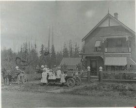
Madill family and house
https://search.heritageburnaby.ca/link/museumdescription832
- Repository
- Burnaby Village Museum
- Date
- 1911 (date of original), copied 1976
- Collection/Fonds
- Burnaby Village Museum Photograph collection
- Description Level
- Item
- Physical Description
- 1 photograph : b&w ; 20 x 25 cm print
- Scope and Content
- Photograph of a large two storey brick house, with a balcony on the second floor, and striped awnings over the windows. There is a wire fence around the property. In front of the house is Madill family in and around a car; six children of various ages and a couple. A horse drawn wagon is on the lef…
- Repository
- Burnaby Village Museum
- Collection/Fonds
- Burnaby Village Museum Photograph collection
- Description Level
- Item
- Physical Description
- 1 photograph : b&w ; 20 x 25 cm print
- Scope and Content
- Photograph of a large two storey brick house, with a balcony on the second floor, and striped awnings over the windows. There is a wire fence around the property. In front of the house is Madill family in and around a car; six children of various ages and a couple. A horse drawn wagon is on the left side of the photograph.
- Subjects
- Buildings - Residential - Houses
- Geographic Access
- Canada Way
- Imperial Street
- Accession Code
- HV976.146.1
- Access Restriction
- No restrictions
- Reproduction Restriction
- No known restrictions
- Date
- 1911 (date of original), copied 1976
- Media Type
- Photograph
- Historic Neighbourhood
- Edmonds (Historic Neighbourhood)
- Scan Resolution
- 600
- Scan Date
- 2023-06-27
- Notes
- Title based on contents of photograph
- An annotation on the back of the photo reads, "Home of Rev. Madill at Canada Way + Imperial 1911."
Images


Schou Street School site
https://search.heritageburnaby.ca/link/museumdescription11138
- Repository
- Burnaby Village Museum
- Date
- April 12, 1915
- Collection/Fonds
- Ronald G. Scobbie collection
- Description Level
- Item
- Physical Description
- 1 survey plan : blueprint on paper ; 56 x 54 cm
- Scope and Content
- Survey plan of "Schou Street School Site / Burnaby Municipality" "Being Lot 1-12 inc. of Block 47, of subd. of Blocks 8-12 and 15-49 inclusive, Lot 69, Group 1" "New Westminster District";
- Repository
- Burnaby Village Museum
- Collection/Fonds
- Ronald G. Scobbie collection
- Description Level
- Item
- Physical Description
- 1 survey plan : blueprint on paper ; 56 x 54 cm
- Material Details
- Scale 40 feet = 1 inch
- Scope and Content
- Survey plan of "Schou Street School Site / Burnaby Municipality" "Being Lot 1-12 inc. of Block 47, of subd. of Blocks 8-12 and 15-49 inclusive, Lot 69, Group 1" "New Westminster District";
- Creator
- Burnett, Geoffrey K.
- Subjects
- Buildings - Schools
- Names
- Schou Street School
- Responsibility
- Burnett & McGugan, Engineers and Surveyors
- Geographic Access
- Canada Way
- Grandview Highway
- Gilmore Avenue
- Street Address
- 4054 Norfolk Street
- Accession Code
- BV003.83.17
- Access Restriction
- No restrictions
- Reproduction Restriction
- No known restrictions
- Date
- April 12, 1915
- Media Type
- Cartographic Material
- Historic Neighbourhood
- Broadview (Historic Neighbourhood)
- Planning Study Area
- Cascade-Schou Area
- Scan Resolution
- 440
- Scan Date
- 22-Dec-2020
- Scale
- 100
- Notes
- Title based on contents of plan
- Oath on plan reads: "I, Geoffrey K. Burnett...did person- ally superintend the survey..." "...completed on the 12th day of April 1915"; signed by Geoffrey K. Burnett, notarized by "S.F. Mark", sworn "..12th day.. April 1915" "Burnett and McGugan" "B.C. Land Surveyors Etc. New Westminster, B.C.
- ."handwritten on back, "1751"
- two school buildings are shown on this blueprint, "Old School Building", "New School Building"
Images


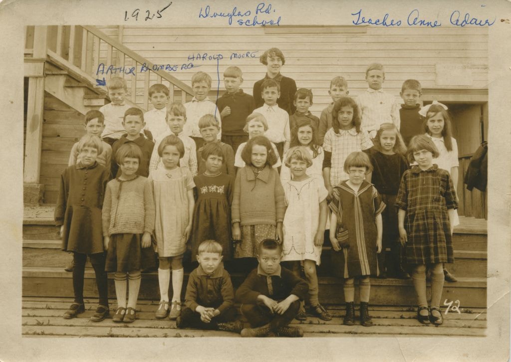
Students at Douglas Road School
https://search.heritageburnaby.ca/link/museumdescription78
- Repository
- Burnaby Village Museum
- Date
- 1925
- Collection/Fonds
- Burnaby Village Museum Photograph collection
- Description Level
- Item
- Physical Description
- 1 photograph : sepia ; 10.5 x 16 cm
- Scope and Content
- Photograph of students on the steps of Douglas Road School with their teacher, Annie Adair, standing in the centre at the very back. The boy standing on the extreme left at the back row is identified as Arthur Blomberg and the boy standing 4th from the left in the middle row is Harold Moore. The ot…
- Repository
- Burnaby Village Museum
- Collection/Fonds
- Burnaby Village Museum Photograph collection
- Description Level
- Item
- Physical Description
- 1 photograph : sepia ; 10.5 x 16 cm
- Scope and Content
- Photograph of students on the steps of Douglas Road School with their teacher, Annie Adair, standing in the centre at the very back. The boy standing on the extreme left at the back row is identified as Arthur Blomberg and the boy standing 4th from the left in the middle row is Harold Moore. The other students are not identified.
- Subjects
- Occupations - Teachers
- Geographic Access
- Canada Way
- Street Address
- 4861 Canada Way
- Accession Code
- BV989.28.1
- Access Restriction
- No restrictions
- Date
- 1925
- Media Type
- Photograph
- Historic Neighbourhood
- Burnaby Lake (Historic Neighbourhood)
- Planning Study Area
- Douglas-Gilpin Area
- Scan Resolution
- 600
- Scan Date
- 01-Jun-09
- Scale
- 100
- Notes
- Title based on contents of photograph
- Photographer identifies photograph as no. 42
- Notes on recto of photograph read: "Douglas Rd. school / Teacher Anne Adair / ARTHUR BLOMBERG / HAROLD MOORE" and "1925"
Images

Students at Douglas Road School
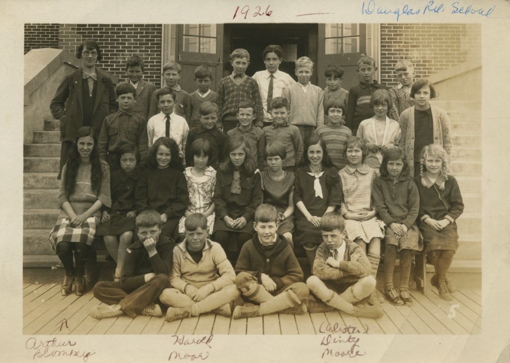
https://search.heritageburnaby.ca/link/museumdescription79
- Repository
- Burnaby Village Museum
- Date
- 1926
- Collection/Fonds
- Burnaby Village Museum Photograph collection
- Description Level
- Item
- Physical Description
- 1 photograph : b&w ; 10.5 x 15.5 cm
- Scope and Content
- Photograph of students sitting and standing on the steps of Douglas Road School with their teacher (wearing glasses and an overcoat) on the far left at the back. In the front row, Arthur Blomberg is sitting on the far left, next to him is Harold Moore, with William A. "Dinty" Moore on the far right…
- Repository
- Burnaby Village Museum
- Collection/Fonds
- Burnaby Village Museum Photograph collection
- Description Level
- Item
- Physical Description
- 1 photograph : b&w ; 10.5 x 15.5 cm
- Scope and Content
- Photograph of students sitting and standing on the steps of Douglas Road School with their teacher (wearing glasses and an overcoat) on the far left at the back. In the front row, Arthur Blomberg is sitting on the far left, next to him is Harold Moore, with William A. "Dinty" Moore on the far right. The other students are not identified.
- Subjects
- Occupations - Teachers
- Geographic Access
- Canada Way
- Street Address
- 4861 Canada Way
- Accession Code
- BV989.28.2
- Access Restriction
- No restrictions
- Date
- 1926
- Media Type
- Photograph
- Historic Neighbourhood
- Burnaby Lake (Historic Neighbourhood)
- Planning Study Area
- Douglas-Gilpin Area
- Scan Resolution
- 600
- Scan Date
- 01-Jun-09
- Scale
- 100
- Notes
- Title based on contents of photograph
- Photographer identifies photograph as no. 5
- Notes on recto of photograph read: "Douglas Rd. School" and "1926 / Arthur Blomberg / Harold Moore / (Alister) Dinty Moore"
Images

Students at Douglas Road School
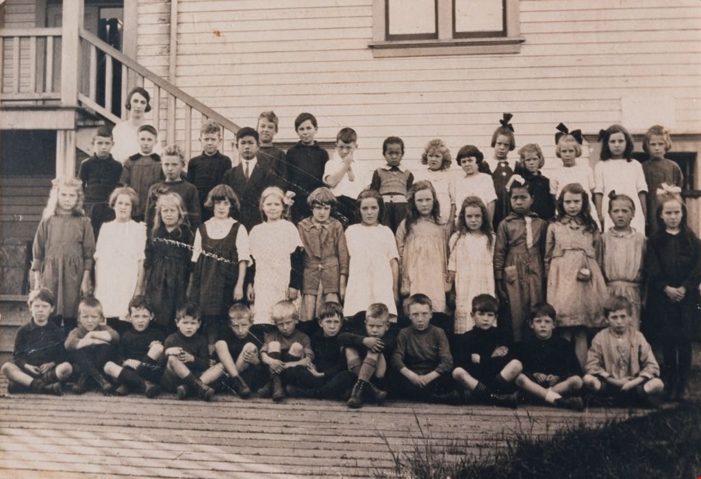
https://search.heritageburnaby.ca/link/museumdescription1377
- Repository
- Burnaby Village Museum
- Date
- 1920
- Collection/Fonds
- Burnaby Village Museum Photograph collection
- Description Level
- Item
- Physical Description
- 1 photograph : sepia ; 17.5 x 25.5 cm print
- Scope and Content
- Photograph of Elsie Rummel (later McMurray) standing behind her students who are sitting and standing in rows outside Douglas Road school. Standing in the back two rows, left to right are; Jack Lort, Billy Mather, Teddy Norman (slightly in front), Ed Gavin, David Jung (slightly in front), Leonard R…
- Repository
- Burnaby Village Museum
- Collection/Fonds
- Burnaby Village Museum Photograph collection
- Description Level
- Item
- Physical Description
- 1 photograph : sepia ; 17.5 x 25.5 cm print
- Scope and Content
- Photograph of Elsie Rummel (later McMurray) standing behind her students who are sitting and standing in rows outside Douglas Road school. Standing in the back two rows, left to right are; Jack Lort, Billy Mather, Teddy Norman (slightly in front), Ed Gavin, David Jung (slightly in front), Leonard Rowley, Dave Banning, Herbert McConnell, Ying Jung, Gwendolyn Matthews, Avis Hart, Florence Cowan, Nancy Burnett, Winona Wood, Leona Smith, Sadie Bowie [or Dorothy Marsden]. Standing in the middle row are; Nora Rowley, Eva Dunnell [or Donnel], Rena Blomberg (later Ostby), Audrey [or Helen] Pontifex, Ruth Cole, Anna Matthews, Agnes Angus, Rhoda Gavin, Ruby Boucher, King Jung, Mary Lee, Frances "Fanny" Waplington (later Fleming), Beryl Hatch. Seated in the front row are; John Burnett [or Freddy Bogardus], John Waplington, Billy Townley, Roddie Saunders, Clive Cunningham, Ken Blott, Carl Banning, Doug Tyre, Bert Dawkins, Montague "Monty" Moore, John Moore and Alistair Westcott.
- Subjects
- Occupations - Teachers
- Names
- Douglas Road School
- McMurray, Elsie Rummel
- Lort, Jack
- Mather, Billy
- Norman, Teddy
- Gavin, Ed
- Jung, David
- Rowley, Leonard
- Banning, Dave
- McConnell, Herbert
- Jung, Suey Ying "Laura"
- Matthews, Gwendolyn
- Hart, Avis
- Cowan, Florence
- Burnett, Nancy
- Wood, Winona
- Smith, Leona
- Rowley, Nora
- Ostby, Rena Blomberg
- Cole, Ruth
- Matthews, Anna
- Angus, Agnes
- Gavin, Rhoda
- Boucher, Ruby
- Jung, King
- Lee, Mary
- Fleming, Frances "Fanny" Waplington
- Hatch, Beryl
- Waplington, John
- Townley, Billy
- Saunders, Roddie
- Cunningham, Clive
- Blott, Ken
- Banning, Carl
- Tyre, Doug
- Dawkins, Bert
- Moore, Montague Hutchings "Monty"
- Moore, John Gifford
- Westcott, Alistair
- Geographic Access
- Canada Way
- Street Address
- 4861 Canada Way
- Accession Code
- BV999.4.1
- Access Restriction
- No restrictions
- Reproduction Restriction
- No known restrictions
- Date
- 1920
- Media Type
- Photograph
- Historic Neighbourhood
- Burnaby Lake (Historic Neighbourhood)
- Planning Study Area
- Douglas-Gilpin Area
- Scan Resolution
- 600
- Scan Date
- 08-Jun-09
- Scale
- 100
- Notes
- Title based on contents of photograph
Images