Narrow Results By
Decade
- 2020s 182
- 2010s 233
- 2000s 310
- 1990s 1027
- 1980s 844
- 1970s 2042
- 1960s 738
- 1950s 895
- 1940s 1204
- 1930s 1350
- 1920s 1594
- 1910s 1568
- 1900s 969
- 1890s
- 1880s 141
- 1870s
- 1860s 52
- 1850s 26
- 1840s 17
- 1830s 8
- 1820s 5
- 1810s 5
- 1800s 8
- 1790s 4
- 1780s 3
- 1770s 3
- 1760s 3
- 1750s 3
- 1740s 3
- 1730s 3
- 1720s 3
- 1710s 5
- 1700s 4
- 1690s 3
- 1680s 4
- 1670s 3
- 1660s 3
- 1650s 3
- 1640s 3
- 1630s 3
- 1620s 3
- 1610s 3
- 1600s 3
- 1520s 1
Subject
- Adornment - Jewelry 2
- Agriculture 1
- Agriculture - Farms 1
- Animals 1
- Animals - Birds 1
- Buildings - Commercial - Grocery Stores 1
- Buildings - Commercial - Stores 1
- Buildings Components - Fireplaces 1
- Buildings - Industrial - Factories 1
- Buildings - Industrial - Saw Mills 1
- Buildings - Residential - Houses 2
- Celebrations - Jubilee 1
Creator
- Adams, Albert Egerton 1
- Adams, John Macgregor 1
- Alexander, William John, 1855-1944 1
- Alger, Horatio, Jr., 1832-1899 2
- A. L. O. E., 1821-1893 1
- Altemus, Henry 1
- Ames, A. F. (Albert Flintoft) 1
- Anger, William Henry 1
- Archer, Thomas, 1830-1893 1
- Ashe, T. (Thomas), 1836-1889 1
- Atkinson, J. 3
- Baldwin, Joseph, 1827-1899 1
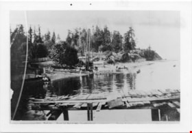
Waterfront Looking west from George Black's
https://search.heritageburnaby.ca/link/museumdescription4775
- Repository
- Burnaby Village Museum
- Date
- 1890-1915
- Collection/Fonds
- Burnaby Village Museum Photograph collection
- Description Level
- Item
- Physical Description
- 1 photograph : b&w ; 8.5 x 12.5 cm ; copy print
- Scope and Content
- Waterfront scene with land on left and water on right. Wooden dock/jetty in foreground. From left to right along the shore there are people wading, a maple tree, a slaughterhouse, a cattle yard, boating bathers, fishing. Trees and houses in background.
- Repository
- Burnaby Village Museum
- Collection/Fonds
- Burnaby Village Museum Photograph collection
- Description Level
- Item
- Physical Description
- 1 photograph : b&w ; 8.5 x 12.5 cm ; copy print
- Material Details
- "Looking west from George Black's. Wading. Maple Tree. Marine ways. Saughterhouse. Cattleyard. Boating Bathers. Fishing. […]" written in black ink on bottom front of photograph. "Columbian files 1971" written on verso in black pen. "996" stamped on back.
- Scope and Content
- Waterfront scene with land on left and water on right. Wooden dock/jetty in foreground. From left to right along the shore there are people wading, a maple tree, a slaughterhouse, a cattle yard, boating bathers, fishing. Trees and houses in background.
- History
- Part of a set of photographs from the Columbian Newspaper, which operated out of New Westminster under this name starting in 1900 until its dissolution in 1988. Photographs found in the collection of the Burnaby Village are dated 1971. George Black (1831-1896). He was born in Aberdeen Scotland, and went to California, then to the Cariboo during the gold rush. He eventually settled on Hastings Street, and was well known in the surroundings of Vancouver.
- Other Title Information
- title based on content and note on front of photograph
- Names
- Black, George
- Accession Code
- BV018.19.1
- Access Restriction
- No restrictions
- Reproduction Restriction
- May be restricted by third party rights
- Date
- 1890-1915
- Media Type
- Photograph
- Scan Resolution
- 600
- Scan Date
- 24-04-2018
Images

![Threshing outfit in Burnaby on Fraser River, [1892] thumbnail](/media/hpo/_Data/_BVM_Images/2018/2018_0019_0002_001.jpg?width=280)
Threshing outfit in Burnaby on Fraser River
https://search.heritageburnaby.ca/link/museumdescription4776
- Repository
- Burnaby Village Museum
- Date
- [1892]
- Collection/Fonds
- Burnaby Village Museum Photograph collection
- Description Level
- Item
- Physical Description
- 1 photograph : b&w ; 8.9 x 8.9 cm ; copy print
- Scope and Content
- Threshing machine on paddlewheel barge on river. Five men standing on barge.
- Repository
- Burnaby Village Museum
- Collection/Fonds
- Burnaby Village Museum Photograph collection
- Description Level
- Item
- Physical Description
- 1 photograph : b&w ; 8.9 x 8.9 cm ; copy print
- Material Details
- "Ist Threshing outfit in Burnaby, about 1892. / Owned by Pat Byrne, brother of Peter. Sold to / Peter when Pat returned to Ireland to live. / ON Fraser River. L. to R. : Pat Byrne, Capt. Stewart / of "Alice", Peter Byrne and Another (unknown)." on typewritten label on front of photograph. "Columbian files" written on verso in black pen.
- Scope and Content
- Threshing machine on paddlewheel barge on river. Five men standing on barge.
- History
- Part of a set of photographs from the Columbian Newspaper, which operated out of New Westminster under this name starting in 1900 until its dissolution in 1988. Photographs found in the collection of the Burnaby Village are dated 1971.
- Other Title Information
- title based on note on front of photograph
- Names
- Byrne, Pat
- Accession Code
- BV018.19.2
- Access Restriction
- No restrictions
- Reproduction Restriction
- May be restricted by third party rights
- Date
- [1892]
- Media Type
- Photograph
- Scan Resolution
- 600
- Scan Date
- 24-04-2018
Images
![Threshing outfit in Burnaby on Fraser River, [1892] thumbnail](/media/hpo/_Data/_BVM_Images/2018/2018_0019_0002_001.jpg)
![Horseless carriage with 4 passengers, [189-] thumbnail](/media/hpo/_Data/_BVM_Images/2018/2018_0019_0004_001.jpg?width=280)
Horseless carriage with 4 passengers
https://search.heritageburnaby.ca/link/museumdescription4778
- Repository
- Burnaby Village Museum
- Date
- [189-]
- Collection/Fonds
- Burnaby Village Museum Photograph collection
- Description Level
- Item
- Physical Description
- 1 photograph : b&w ; 8.9 x 8.9 cm ; copy print
- Scope and Content
- Horseless carriage carrying three men, two seated and one standing, with one woman seated on side fender. Carriage faces towards the right.
- Repository
- Burnaby Village Museum
- Collection/Fonds
- Burnaby Village Museum Photograph collection
- Description Level
- Item
- Physical Description
- 1 photograph : b&w ; 8.9 x 8.9 cm ; copy print
- Material Details
- "Columbian files 1971" written on verso in black pen.
- Scope and Content
- Horseless carriage carrying three men, two seated and one standing, with one woman seated on side fender. Carriage faces towards the right.
- History
- Part of a set of photographs from the Columbian Newspaper, which operated out of New Westminster under this name starting in 1900 until its dissolution in 1988. Photographs found in the collection of the Burnaby Village are dated 1971.
- Other Title Information
- title based on content of photograph
- Accession Code
- BV018.19.4
- Access Restriction
- No restrictions
- Reproduction Restriction
- May be restricted by third party rights
- Date
- [189-]
- Media Type
- Photograph
- Scan Resolution
- 600
- Scan Date
- 24-04-2018
Images
![Horseless carriage with 4 passengers, [189-] thumbnail](/media/hpo/_Data/_BVM_Images/2018/2018_0019_0004_001.jpg)
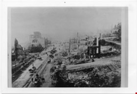
Aftermath of Great Fire of New Westminster, 1898
https://search.heritageburnaby.ca/link/museumdescription4781
- Repository
- Burnaby Village Museum
- Date
- 1898
- Collection/Fonds
- Burnaby Village Museum Photograph collection
- Description Level
- Item
- Physical Description
- 1 photograph : b&w ; 8.8 x 12.7 cm ; copy print
- Scope and Content
- Brick ruins of buildings on either side of a street with people, wagons and horses. Street runs top to bottom on left hand side of photograph.
- Repository
- Burnaby Village Museum
- Collection/Fonds
- Burnaby Village Museum Photograph collection
- Description Level
- Item
- Physical Description
- 1 photograph : b&w ; 8.8 x 12.7 cm ; copy print
- Material Details
- "Columbian files 1971" written on verso in black pen. ""FIRE" NEW WESTMINSTER SEPT. 1898." written on verso in pencil.
- Scope and Content
- Brick ruins of buildings on either side of a street with people, wagons and horses. Street runs top to bottom on left hand side of photograph.
- History
- Part of a set of photographs from the Columbian Newspaper, which operated out of New Westminster under this name starting in 1900 until its dissolution in 1988. Photographs found in the collection of the Burnaby Village are dated 1971.
- Other Title Information
- title based on content and note on verso of photograph
- Accession Code
- BV018.19.7
- Access Restriction
- No restrictions
- Reproduction Restriction
- May be restricted by third party rights
- Date
- 1898
- Media Type
- Photograph
- Scan Resolution
- 600
- Scan Date
- 24-04-2018
Images


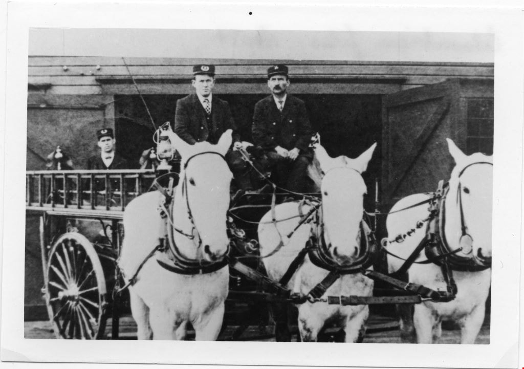
Two uniformed men driving wagon
https://search.heritageburnaby.ca/link/museumdescription4784
- Repository
- Burnaby Village Museum
- Date
- 1890-1920
- Collection/Fonds
- Burnaby Village Museum Photograph collection
- Description Level
- Item
- Physical Description
- 1 photograph : b&w ; 8.7 x 12.7 cm ; copy print
- Scope and Content
- Two uniformed men driving horse-drawn wagon. Picture taken from front shows three grey horses head-on in harness. Shed or garage in background. Third man in uniform standing behind wagon.
- Repository
- Burnaby Village Museum
- Collection/Fonds
- Burnaby Village Museum Photograph collection
- Description Level
- Item
- Physical Description
- 1 photograph : b&w ; 8.7 x 12.7 cm ; copy print
- Material Details
- "Columbian files 1971" written on verso in black pen.
- Scope and Content
- Two uniformed men driving horse-drawn wagon. Picture taken from front shows three grey horses head-on in harness. Shed or garage in background. Third man in uniform standing behind wagon.
- History
- Part of a set of photographs from the Columbian Newspaper, which operated out of New Westminster under this name starting in 1900 until its dissolution in 1988. Photographs found in the collection of the Burnaby Village are dated 1971.
- Other Title Information
- title based on content of photograph
- Accession Code
- BV018.19.10
- Access Restriction
- No restrictions
- Reproduction Restriction
- May be restricted by third party rights
- Date
- 1890-1920
- Media Type
- Photograph
- Scan Resolution
- 600
- Scan Date
- 24-04-2018
Images
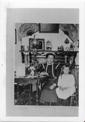
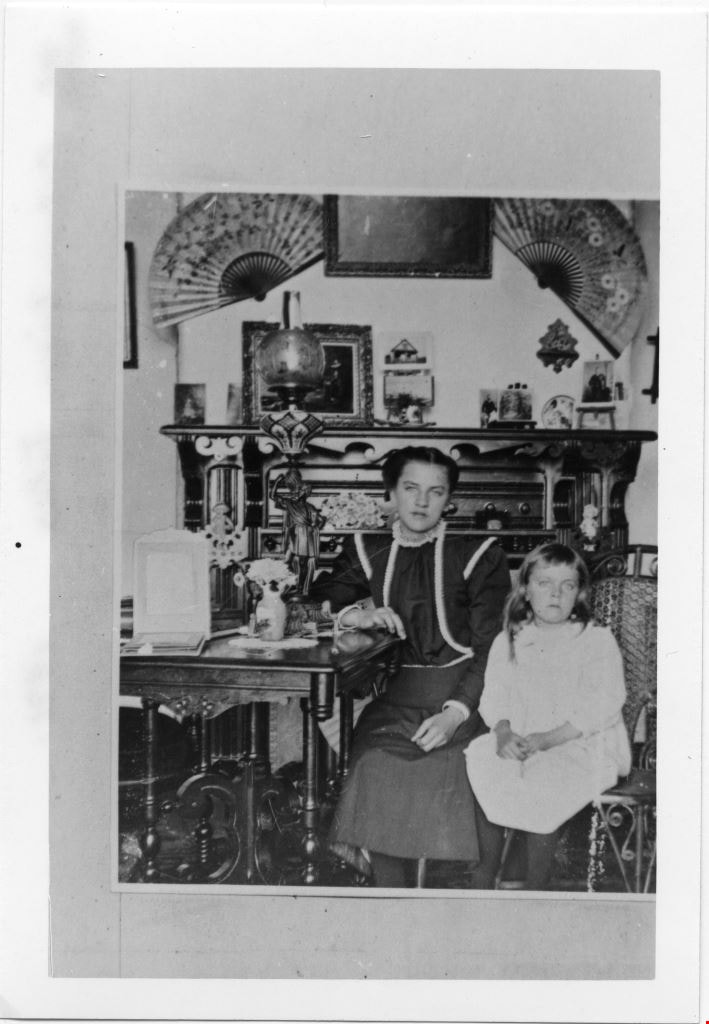
Woman and girl seated in front of fireplace
https://search.heritageburnaby.ca/link/museumdescription4785
- Repository
- Burnaby Village Museum
- Date
- 1890-1915
- Collection/Fonds
- Burnaby Village Museum Photograph collection
- Description Level
- Item
- Physical Description
- 1 photograph : b&w ; 12.7 x 8.10 cm ; copy print
- Scope and Content
- Woman and girl seated in front of ornate fireplace. Woman in dark clothing. Girl in white. Woman leans right arm on table. Two open fans on wall abover mantlepiece.
- Repository
- Burnaby Village Museum
- Collection/Fonds
- Burnaby Village Museum Photograph collection
- Description Level
- Item
- Physical Description
- 1 photograph : b&w ; 12.7 x 8.10 cm ; copy print
- Material Details
- "The Columbian files 1971" written on verso in black pen.
- Scope and Content
- Woman and girl seated in front of ornate fireplace. Woman in dark clothing. Girl in white. Woman leans right arm on table. Two open fans on wall abover mantlepiece.
- History
- Part of a set of photographs from the Columbian Newspaper, which operated out of New Westminster under this name starting in 1900 until its dissolution in 1988. Photographs found in the collection of the Burnaby Village are dated 1971.
- Other Title Information
- title based on content of photograph
- Accession Code
- BV018.19.11
- Access Restriction
- No restrictions
- Reproduction Restriction
- May be restricted by third party rights
- Date
- 1890-1915
- Media Type
- Photograph
- Scan Resolution
- 600
- Scan Date
- 24-04-2018
Images

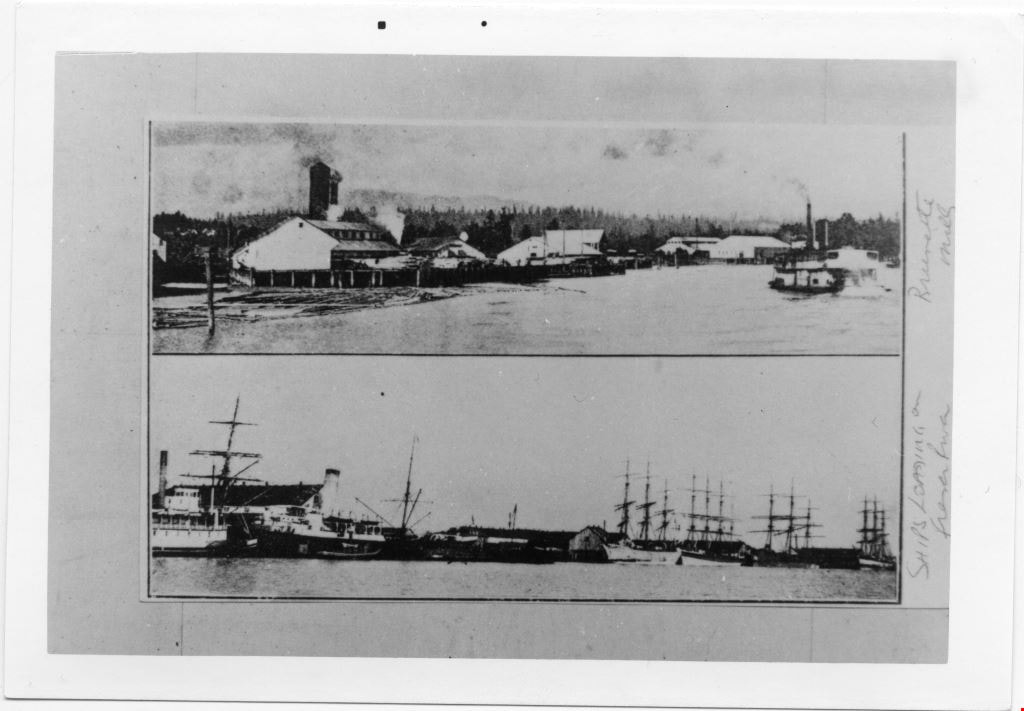
Ships loading on Fraser River, and Brunette Mills
https://search.heritageburnaby.ca/link/museumdescription4786
- Repository
- Burnaby Village Museum
- Date
- 1890-1910
- Collection/Fonds
- Burnaby Village Museum Photograph collection
- Description Level
- Item
- Physical Description
- 1 photograph : b&w ; 8.7 x 12.8 cm ; copy print
- Scope and Content
- Two pictures on above the other. Top picture is of lumber mill beside river with boats. Bottom picture is of approximately six tall ships at dock on river.
- Repository
- Burnaby Village Museum
- Collection/Fonds
- Burnaby Village Museum Photograph collection
- Description Level
- Item
- Physical Description
- 1 photograph : b&w ; 8.7 x 12.8 cm ; copy print
- Material Details
- "Columbian files 1971" written on verso in black pen. "Brunette Mills" written beside top picture. "SHIPS LOADING on / Fraser River" written beside bottom picture.
- Scope and Content
- Two pictures on above the other. Top picture is of lumber mill beside river with boats. Bottom picture is of approximately six tall ships at dock on river.
- History
- Part of a set of photographs from the Columbian Newspaper, which operated out of New Westminster under this name starting in 1900 until its dissolution in 1988. Photographs found in the collection of the Burnaby Village are dated 1971.
- Other Title Information
- title based on content and note on front of photograph
- Accession Code
- BV018.19.12
- Access Restriction
- No restrictions
- Reproduction Restriction
- May be restricted by third party rights
- Date
- 1890-1910
- Media Type
- Photograph
- Scan Resolution
- 600
- Scan Date
- 24-04-2018
Images
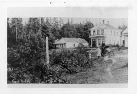
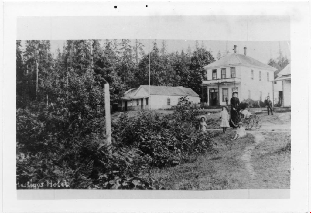
Family group in grounds of Hastings Hotel
https://search.heritageburnaby.ca/link/museumdescription4787
- Repository
- Burnaby Village Museum
- Date
- 1890-1905
- Collection/Fonds
- Burnaby Village Museum Photograph collection
- Description Level
- Item
- Physical Description
- 1 photograph : b&w ; 8.8 x 12.7 cm ; copy print
- Scope and Content
- Shrubs on left and trees in background. On right a woman with 3 children and one infant in pram. On right two and one partial white buildings in background. Two men in background. Writing on bottom left edge.
- Repository
- Burnaby Village Museum
- Collection/Fonds
- Burnaby Village Museum Photograph collection
- Description Level
- Item
- Physical Description
- 1 photograph : b&w ; 8.8 x 12.7 cm ; copy print
- Material Details
- "Columbian files Nov 71" written on verso in black pen. "Hastings Hotel" written in white on front bottom left of photograph.
- Scope and Content
- Shrubs on left and trees in background. On right a woman with 3 children and one infant in pram. On right two and one partial white buildings in background. Two men in background. Writing on bottom left edge.
- History
- Part of a set of photographs from the Columbian Newspaper, which operated out of New Westminster under this name starting in 1900 until its dissolution in 1988. Photographs found in the collection of the Burnaby Village are dated 1971.
- Other Title Information
- title based on note on and content of photograph
- Accession Code
- BV018.19.13
- Access Restriction
- No restrictions
- Reproduction Restriction
- May be restricted by third party rights
- Date
- 1890-1905
- Media Type
- Photograph
- Scan Resolution
- 600
- Scan Date
- 24-04-2018
Images
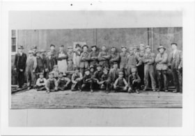
Group portrait of 34 men and boys
https://search.heritageburnaby.ca/link/museumdescription4788
- Repository
- Burnaby Village Museum
- Date
- 1890-1900
- Collection/Fonds
- Burnaby Village Museum Photograph collection
- Description Level
- Item
- Physical Description
- 1 photograph : b&w ; 8.9 x 13.8 cm ; copy print
- Scope and Content
- Group portrait of 34 men and boys in front of a wooden building. 21 standing in back row. 13 kneeling or crouching in front row. One man standing on far left is wearing a suit and tie, all others are wearing overalls, some with aprons.
- Repository
- Burnaby Village Museum
- Collection/Fonds
- Burnaby Village Museum Photograph collection
- Description Level
- Item
- Physical Description
- 1 photograph : b&w ; 8.9 x 13.8 cm ; copy print
- Material Details
- "Columbian files Nov 71" written on verso in black pen.
- Scope and Content
- Group portrait of 34 men and boys in front of a wooden building. 21 standing in back row. 13 kneeling or crouching in front row. One man standing on far left is wearing a suit and tie, all others are wearing overalls, some with aprons.
- History
- Part of a set of photographs from the Columbian Newspaper, which operated out of New Westminster under this name starting in 1900 until its dissolution in 1988. Photographs found in the collection of the Burnaby Village are dated 1971.
- Other Title Information
- title based on content of photograph
- Accession Code
- BV018.19.14
- Access Restriction
- No restrictions
- Reproduction Restriction
- May be restricted by third party rights
- Date
- 1890-1900
- Media Type
- Photograph
- Scan Resolution
- 600
- Scan Date
- 24-04-2018
Images
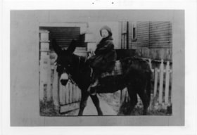
Child on donkey
https://search.heritageburnaby.ca/link/museumdescription4789
- Repository
- Burnaby Village Museum
- Date
- 1890-1900
- Collection/Fonds
- Burnaby Village Museum Photograph collection
- Description Level
- Item
- Physical Description
- 1 photograph : b&w ; 8.9 x 13.8 cm ; copy print
- Scope and Content
- Child mounted on saddled donkey facing left. Child's feet do not reach stirrups. Saddle blanket is plaid. Background includes wooden slatted buildings and picket fence.
- Repository
- Burnaby Village Museum
- Collection/Fonds
- Burnaby Village Museum Photograph collection
- Description Level
- Item
- Physical Description
- 1 photograph : b&w ; 8.9 x 13.8 cm ; copy print
- Material Details
- "Columbian files 1971." written on verso in black pen. "031" stamped on verso.
- Scope and Content
- Child mounted on saddled donkey facing left. Child's feet do not reach stirrups. Saddle blanket is plaid. Background includes wooden slatted buildings and picket fence.
- History
- Part of a set of photographs from the Columbian Newspaper, which operated out of New Westminster under this name starting in 1900 until its dissolution in 1988. Photographs found in the collection of the Burnaby Village are dated 1971.
- Other Title Information
- title based on content of photograph
- Accession Code
- BV018.19.15
- Access Restriction
- No restrictions
- Reproduction Restriction
- May be restricted by third party rights
- Date
- 1890-1900
- Media Type
- Photograph
- Scan Resolution
- 600
- Scan Date
- 24-04-2018
Images

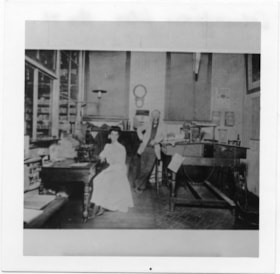
Woman and man in office
https://search.heritageburnaby.ca/link/museumdescription4791
- Repository
- Burnaby Village Museum
- Date
- 1890-1914
- Collection/Fonds
- Burnaby Village Museum Photograph collection
- Description Level
- Item
- Physical Description
- 1 photograph : b&w ; 8.8 x 8.9 cm ; copy print
- Scope and Content
- Interior of business office. On the left 1 woman is seated at a desk with a typewriter and a cash register. On the right 1 man is standing and leaning his left elbow on a tall desk. Two windows in background have blinds pulled down.
- Repository
- Burnaby Village Museum
- Collection/Fonds
- Burnaby Village Museum Photograph collection
- Description Level
- Item
- Physical Description
- 1 photograph : b&w ; 8.8 x 8.9 cm ; copy print
- Material Details
- "Columbian files Nov 71" written on verso in black pen.
- Scope and Content
- Interior of business office. On the left 1 woman is seated at a desk with a typewriter and a cash register. On the right 1 man is standing and leaning his left elbow on a tall desk. Two windows in background have blinds pulled down.
- History
- Part of a set of photographs from the Columbian Newspaper, which operated out of New Westminster under this name starting in 1900 until its dissolution in 1988. Photographs found in the collection of the Burnaby Village are dated 1971.
- Other Title Information
- title based on content of photograph
- Accession Code
- BV018.19.17
- Access Restriction
- No restrictions
- Reproduction Restriction
- May be restricted by third party rights
- Date
- 1890-1914
- Media Type
- Photograph
- Scan Resolution
- 600
- Scan Date
- 24-04-2018
Images

![Subdivision plans in New Westminster District Group 1 – Burnaby
, [1882-1910] thumbnail](/media/hpo/_Data/_BVM_Cartographic_Material/1977/1977_0093_0013a_001.jpg?width=280)
Subdivision plans in New Westminster District Group 1 – Burnaby
https://search.heritageburnaby.ca/link/museumdescription6982
- Repository
- Burnaby Village Museum
- Date
- [1882-1910]
- Collection/Fonds
- Burnaby Village Museum Map collection
- Description Level
- File
- Physical Description
- 4 plans : blueprint on paper mounted on 2 sides of cardboard 76 x 102 cm
- Scope and Content
- Item consists of a large board of two New Westminster District Gp 1 - subdivision plans mounted on one side and two New Westminster District Gp 1 - subdivision plans mounted on the other side. Side A: 1. Blueprint "Plan / of the / Subdivision / of / Lot 98 / G.1, N.W.D. / Scale 4 chs = 1 in. / …
- Repository
- Burnaby Village Museum
- Collection/Fonds
- Burnaby Village Museum Map collection
- Description Level
- File
- Physical Description
- 4 plans : blueprint on paper mounted on 2 sides of cardboard 76 x 102 cm
- Material Details
- Scales [between 1:1584 and 1:3168]
- Index number on edge of board reads: "13"
- Scope and Content
- Item consists of a large board of two New Westminster District Gp 1 - subdivision plans mounted on one side and two New Westminster District Gp 1 - subdivision plans mounted on the other side. Side A: 1. Blueprint "Plan / of the / Subdivision / of / Lot 98 / G.1, N.W.D. / Scale 4 chs = 1 in. / Map No 573" (Geographic location: Burnaby) 2. Blueprint "Plan / of Subdivision of / Lot 157 / Gr.1, New. West. Dist. / Scale 3 chs = 1 in. / Map No. 612". (Geographic location: Burnaby) Side B: 1. Blueprint "Plan / of Subdivision / of a Portion of / Lot 90 / Group One / New Westminster Dist. / Scale 2 chs = 1 in. / Map No. 555". Plan is signed by "Jno Strathern [sic]_P.L.S."n (Geographic location: Burnaby) 2. Blueprint "Subdivision of Lot 31, Group 1. / New Westminster District / As Amended by Order of Court / 1st Sept. 1882 and Numbered 847 / Scale 4 chs = 1in. / Map No 80" (Geographic location: Burnaby)
- Creator
- Stathern, John
- Accession Code
- HV977.93.13
- Access Restriction
- No restrictions
- Reproduction Restriction
- No known restrictions
- Date
- [1882-1910]
- Media Type
- Cartographic Material
- Historic Neighbourhood
- Alta Vista (Historic Neighbourhood)
- Planning Study Area
- Richmond Park Area
- Lakeview-Mayfield Area
- Scan Resolution
- 300
- Scale
- 72
- Notes
- Title based on contents of file
- Scale is measured in chains. (One chain equals 792 inches)
- The term "Lot" can also refer to a "District Lot”
Images
![Subdivision plans in New Westminster District Group 1 – Burnaby
, [1882-1910] thumbnail](/media/hpo/_Data/_BVM_Cartographic_Material/1977/1977_0093_0013a_001.jpg)

![Subdivision plans in New Westminster District Group 1 – Burnaby
, [1890-1910] thumbnail](/media/hpo/_Data/_BVM_Cartographic_Material/1977/1977_0093_0014a_001.jpg?width=280)
Subdivision plans in New Westminster District Group 1 – Burnaby
https://search.heritageburnaby.ca/link/museumdescription6983
- Repository
- Burnaby Village Museum
- Date
- [1890-1910]
- Collection/Fonds
- Burnaby Village Museum Map collection
- Description Level
- File
- Physical Description
- 4 plans : blueprint ink on paper mounted on 2 sides of cardboard 76 x 102 cm
- Scope and Content
- Item consists of a large board of two New Westminster District Gp 1 - subdivision plans mounted on one side and two New Westminster District Gp 1 - subdivision plans mounted on the other side. Side A: 1. Blueprint "Plan of / Subdivision of Lot No. 69 / Group One / New Westminster District / Pro…
- Repository
- Burnaby Village Museum
- Collection/Fonds
- Burnaby Village Museum Map collection
- Description Level
- File
- Physical Description
- 4 plans : blueprint ink on paper mounted on 2 sides of cardboard 76 x 102 cm
- Material Details
- Scales [between 1:1584 and 1:3168]
- Index number on edge of board reads: "14"
- Scope and Content
- Item consists of a large board of two New Westminster District Gp 1 - subdivision plans mounted on one side and two New Westminster District Gp 1 - subdivision plans mounted on the other side. Side A: 1. Blueprint "Plan of / Subdivision of Lot No. 69 / Group One / New Westminster District / Property of Ernest Buse, Esq. / Scale 3 chs = 1 in. / Map No 290". Plan is signed by "Garden, Hermon and Burwell, Dom. Land Surveyor" (Geographic location: Burnaby) 2. Blueprint "Plan / of Subdivision / of Lots 1-19, 36-53 and 69-75 inclusive / in the Subdivision / of / Lot 30 / Group One / New Westminster District / Scale 2 chs = 1 in. Map No 631". Plan is signed by "Jno [sic] Strathern [sic] P.L.S." Names and Lot numbers are handwritten in red pencil in sections along Douglas Road and read: "20 - F / 21 - Fitherstruhaul [sic] / 22 - J.S. Craig / 23 - McGill & Dill / 24 / 25 / 26 / 27 / 28 - School / 29 - School / 30 - D. McDownall / 31 - W.J. Troloow [sic] / 32 - N.C. Nelson / 33 - _[sic] McGill / 34 - T.S.[sic] Craig / 35" (Geographic location: Burnaby) Side B: 1.Blueprint "Plan / of Subdivision / of Centre Portion / of Lot 28 / Group One / New Westminster District / Scale 200' = 1" / Map No 627". Plan is signed by "Jno Strathern / P.L.S." (Geographic location: Burnaby) 2. Blueprint "Plan / of Subdivision / of N.1/2 Lot 100 and S.1/2 Lot 101, / Group One / New Westminster District, BC / Scale 4 chs = 1 in." (Geographic location: Burnaby)
- Names
- Strathern, John
- Accession Code
- HV977.93.14
- Access Restriction
- No restrictions
- Reproduction Restriction
- No known restrictions
- Date
- [1890-1910]
- Media Type
- Cartographic Material
- Historic Neighbourhood
- Broadview (Historic Neighbourhood)
- East Burnaby (Historic Neighbourhood)
- Planning Study Area
- Cascade-Schou Area
- West Central Valley Area
- Second Street Area
- Lake City Area
- Scan Resolution
- 300
- Scale
- 72
- Notes
- Title based on contents of file
- Scale is measured in chains and feet. (One chain equals 792 inches)
- The term "Lot" can also refer to a "District Lot”
Images
![Subdivision plans in New Westminster District Group 1 – Burnaby
, [1890-1910] thumbnail](/media/hpo/_Data/_BVM_Cartographic_Material/1977/1977_0093_0014a_001.jpg)

![Subdivision plans in New Westminster District Group 1 – Burnaby
, [1891-1910] thumbnail](/media/hpo/_Data/_BVM_Cartographic_Material/1977/1977_0093_0015a_001.jpg?width=280)
Subdivision plans in New Westminster District Group 1 – Burnaby
https://search.heritageburnaby.ca/link/museumdescription6984
- Repository
- Burnaby Village Museum
- Date
- [1891-1910]
- Collection/Fonds
- Burnaby Village Museum Map collection
- Description Level
- File
- Physical Description
- 4 plans : blueprint ink on paper mounted on 2 sides of cardboard 76 x 102 cm
- Scope and Content
- Item consists of a large board of two New Westminster District Gp 1 - subdivision plans mounted on one side and two New Westminster District Gp 1 - subdivision plans mounted on the other side. Side A: 1. Blueprint "Plan / of Subdivision / of / Lot 29 / Group One / New Westminster District / Scal…
- Repository
- Burnaby Village Museum
- Collection/Fonds
- Burnaby Village Museum Map collection
- Description Level
- File
- Physical Description
- 4 plans : blueprint ink on paper mounted on 2 sides of cardboard 76 x 102 cm
- Material Details
- Scales [between 1:600 and 1:7920]
- Index number on edge of board reads: "15"
- Scope and Content
- Item consists of a large board of two New Westminster District Gp 1 - subdivision plans mounted on one side and two New Westminster District Gp 1 - subdivision plans mounted on the other side. Side A: 1. Blueprint "Plan / of Subdivision / of / Lot 29 / Group One / New Westminster District / Scale 4 chs = 1 in. / Map No 564, Depostd '91". "Reichenbach", dep. Aug. 1891. (Geographic location: Burnaby) 2. Blueprint "Plan / of Subdivision / of / Lot 93 / Group One / New Westminster District / Scale 4 chs = 1 in. / Map No 284". (Geographic location: Burnaby) Side B: 1. Blueprint "Plan / of Subdivision / of a Portion / of / [Lot A of ] Lot 29 / Group One / New Westminster District / Scale 50 ' = 1"" Plan is bordered by Douglas Road to the east, False Creek Trail to the south and Lot 30 to the north. (Geographic location: Burnaby) 2. Blueprint "Plan / of Central Park / and Vicinity / Scale 10 chs = 1 in." (Geographic location: Burnaby)
- Accession Code
- HV977.93.15
- Access Restriction
- No restrictions
- Reproduction Restriction
- No known restrictions
- Date
- [1891-1910]
- Media Type
- Cartographic Material
- Historic Neighbourhood
- Edmonds (Historic Neighbourhood)
- Planning Study Area
- Edmonds Area
- Scan Resolution
- 300
- Scale
- 72
- Notes
- Title based on contents of file
- Scale is measured in chains and feet. (One chain equals 792 inches)
- The term "Lot" can also refer to a "District Lot”
Images
![Subdivision plans in New Westminster District Group 1 – Burnaby
, [1891-1910] thumbnail](/media/hpo/_Data/_BVM_Cartographic_Material/1977/1977_0093_0015a_001.jpg)

![Subdivision plans in New Westminster District Group 1 – Burnaby
, [1893-1910] thumbnail](/media/hpo/_Data/_BVM_Cartographic_Material/1977/1977_0093_0016a_001.jpg?width=280)
Subdivision plans in New Westminster District Group 1 – Burnaby
https://search.heritageburnaby.ca/link/museumdescription6985
- Repository
- Burnaby Village Museum
- Date
- [1893-1910]
- Collection/Fonds
- Burnaby Village Museum Map collection
- Description Level
- File
- Physical Description
- 4 plans : blueprint ink on paper mounted on 2 sides of cardboard 76 x 102 cm
- Scope and Content
- Item consists of a large board of two New Westminster District Gp 1 - subdivision plans mounted on one side and two New Westminster District Gp 1 - subdivision plans mounted on the other side. Side A: 1. Blueprint "Plan / of Subdivision / of / Lot 6 / Group One / New Westminster District / Scale…
- Repository
- Burnaby Village Museum
- Collection/Fonds
- Burnaby Village Museum Map collection
- Description Level
- File
- Physical Description
- 4 plans : blueprint ink on paper mounted on 2 sides of cardboard 76 x 102 cm
- Material Details
- Scales [between 1:1584 and 1:3960]
- Index number on edge of board reads: "16"
- Scope and Content
- Item consists of a large board of two New Westminster District Gp 1 - subdivision plans mounted on one side and two New Westminster District Gp 1 - subdivision plans mounted on the other side. Side A: 1. Blueprint "Plan / of Subdivision / of / Lot 6 / Group One / New Westminster District / Scale 5 chs = 1 in. / Map No 748" (Geographic location: Burnaby) 2. Blueprint "Plan / of Subdivision / of a Portion / of / Lot 29 / Group One / New Westminster Dist. / Scale 2 chs = 1 in. / Map No." Name identified in Block H is "Reichenbach" (Geographic location: Burnaby) Side B: 1. Blueprint "Plan / of Subdivision / of North 1/2 of Lot 80 / Group One / New Westminster District / Scale 3 chs = 1 in. / Map No 719" Plan is signed by: "Garden, Hermon & Burwell P.L.S. / Vancouver Jan. 23rd, 1893" (Geographic location: Burnaby) 2. Blueprint "Plan / of Subdivision / of Lot 79, Gr.1 / New Westminster Dist. / Scale 4 chas = 1 in. / Map No 536" Plan is signed by "Garden Hermon & Burwell / Provincial Land Surveyors". (Geographic location: Burnaby)
- Creator
- Garden, Hermon and Burwell
- Accession Code
- HV977.93.16
- Access Restriction
- No restrictions
- Reproduction Restriction
- No known restrictions
- Date
- [1893-1910]
- Media Type
- Cartographic Material
- Historic Neighbourhood
- Edmonds (Historic Neighbourhood)
- Burnaby Lake (Historic Neighbourhood)
- Planning Study Area
- Douglas-Gilpin Area
- Edmonds Area
- Cameron Area
- Scan Resolution
- 300
- Scale
- 72
- Notes
- Title based on contents of file
- Scale is measured in chains. (One chain equals 792 inches)
- The term "Lot" can also refer to a "District Lot”
Images
![Subdivision plans in New Westminster District Group 1 – Burnaby
, [1893-1910] thumbnail](/media/hpo/_Data/_BVM_Cartographic_Material/1977/1977_0093_0016a_001.jpg)

![Survey and Subdivision plans in New Westminster District Group 1 – Burnaby
, [1861]-[1910] thumbnail](/media/hpo/_Data/_BVM_Cartographic_Material/1977/1977_0093_0019a_001.jpg?width=280)
Survey and Subdivision plans in New Westminster District Group 1 – Burnaby
https://search.heritageburnaby.ca/link/museumdescription6988
- Repository
- Burnaby Village Museum
- Date
- [1861]-[1910]
- Collection/Fonds
- Burnaby Village Museum Map collection
- Description Level
- File
- Physical Description
- 14 plans : 3 plans : black ink on paper hand col. + 7 plans : black ink on paper + 4 plans : graphite on paper mounted on 2 sides of cardboard 76 x 102 cm
- Scope and Content
- Item consists of a large board of four New Westminster District Gp 1 - subdivision plans mounted on one side and ten New Westminster District Gp 1 - subdivision plans mounted on the other side. Side A: 1. "Plan /of / Lots 166A, 166 and 167 /, Gr.1, N.W.D. / Showing Misconstructed Roads in Gree…
- Repository
- Burnaby Village Museum
- Collection/Fonds
- Burnaby Village Museum Map collection
- Description Level
- File
- Physical Description
- 14 plans : 3 plans : black ink on paper hand col. + 7 plans : black ink on paper + 4 plans : graphite on paper mounted on 2 sides of cardboard 76 x 102 cm
- Material Details
- Scales [between 1:2376 and 1:7920]
- Index number on edge of board reads: "19"
- Scope and Content
- Item consists of a large board of four New Westminster District Gp 1 - subdivision plans mounted on one side and ten New Westminster District Gp 1 - subdivision plans mounted on the other side. Side A: 1. "Plan /of / Lots 166A, 166 and 167 /, Gr.1, N.W.D. / Showing Misconstructed Roads in Green / 5 chs = 1 in.". (plan is drawn in black ink and hand coloured in red, green and orange ink). A section in the centre of the plan is coloured in red ink and identified as "C.S. Richmond" running from the North Arm of Fraser River to Wiggins Road and divided by "New Wiggins Rd. (as gazetted)" (coloured in orange ink) and two"Constructed Road(s)" (coloured in green ink). Plan is initialed by: "RB" [sic] (in blue pencil crayon) 2. Plan of / Subdivision of / Lot 166 / Group One / New Westminster District / Scale 4 chs = 1 in. / Map No 524". Plan is drawn in graphite and signed by "Surrig [sic] Welhams [sic] / P.L.S." Plan is initialed by: "RB" [sic] (in blue pencil crayon) 3. Plan of "Survey / of Highway / For / Burnaby Council / in / Lots 13 _14 / Group One / Scale 4 chs = 1 in." Signed by "Albert J. Hill, P.L.S." Caribou Street and Caribou Road run through the centre of the plan. Plan is stamped: "Albert J. Hill, Civil Engineer / and / Provincial Land Surveyor, / New Westminster, / B.C.". Plan is initialed by: "RB" [sic] (in blue pencil crayon) 4. A Plan of Lots 166A, 166 and 167, Group One, New Westminster District (drawn in graphite). A section in the centre of the plan is identified as "C.S. Richmond" running from the North Arm of Fraser River and divided by "New Wiggins Rd. (as gazetted)" and two "Constructed Road(s)". Plan is initialed by: "RB" [sic] (in blue pencil crayon) Side B: 1. Small plan drawn in black ink (no title) identifying lots north of the "North Arm" of the Fraser River. Lots identified include: Lot 99, Lot 98, Lot 157, Lot 158, Lot 163, Lot 162, Lot 159, Lot 163, Lot 162, Lot 165, Lot 166A, Lot 155B, Lot 155A and Lot 159. "Scale 40 chains to one inch" . Plan is initialed by: "RB" [sic] (in blue pencil crayon) (Geographic location: Burnaby) 2. Small plan drawn in black ink (no title) identifying lots north of the North Arm of the Fraser River as "Lots 155, 155A, 155B, 155C, 162, 163, 164, 165, 166A and 167". Plan is initialed by: "RB" [sic] (in blue pencil crayon) (Geographic location: Burnaby) 3. Small plan drawn in black ink (no title) which identifies "Lot 151 / Reserve/ for / Race Course"; "Reserve / 64 A / L. 152 G.1"; and other Lots: 32, 33, 34, 35, 36, 38, 39. The plan is signed "Surveyor G.Turn [sic] July / 61 / from Vol 40 R.L. notes [sic]" Plan is stamped: "Albert J. Hill, Civil Engineer / and / Provincial Land Surveyor, / New Westminster, / B.C." Plan is initialed by: "RB" [sic] (in blue pencil crayon) (Geographic location: Burnaby) 4. Small plan drawn in black in with faded red colouring on centre lot identified as "Lot 34" running north from "Vancouver Road" . Plan is stamped: "Albert J. Hill, Civil Engineer / and / Provincial Land Surveyor, / New Westminster, / B.C." Plan is initialed by: "RB" [sic] (in blue pencil crayon) (Geographic location: Burnaby) 5. Plan drawn in graphite and identified as "Lot 98, Gr.1," along with the intials "RB" [sic] (both are handwritten in blue crayon pencil on top of plan) The B.C.E.Railway is identified running through the plan along with Jubilee Road and Royal Oak Road. The plan is signed with the name "Wm. Murray" and the Plan is stamped: "Albert J. Hill, Civil Engineer / and / Provincial Land Surveyor, / New Westminster, / B.C.". (Geographic location: Burnaby) 6. Plan drawn in graphite identified as "Port Lot 13, Gr.1" along with the intials "RB" [sic] (both are handwritten in blue crayon pencil on top of plan) Plan is stamped: "Albert J. Hill, Civil Engineer / and / Provincial Land Surveyor, / New Westminster, / B.C.". (Geographic location: Burnaby) 7.Plan drawn in black ink and identified as "Lot 98 G.1" along with the intials "RB" [sic] (both are handwritten in blue crayon pencil on top of plan). A "Road Reservation" is identified running north between "Electric Tramway" and connecting with "Royal Oak Road". Plan is stamped: "Albert J. Hill, Civil Engineer / and / Provincial Land Surveyor, / New Westminster, / B.C." (Geographic location: Burnaby) 8. Plan drawn in black ink and divided into two sections, the upper plan is identified as "Portion / Lots 100 / area / 101, Gr.1" and the lower plan is identified as "Portion L. 3 G. 1" along with the intials "RB" [sic] (these identifiers are handwritten in blue crayon pencil on top of the plan). Portions of Lot 100 and Lot 101 are each divided into 6 sections and the Portion of Lot 3 plan is divided into 24 sections. The plan includes a note in black ink that reads: " Received from Wm Fromme [sic] / from Wm. Trapp / Nov. 28, 1895 / A. J. T...[sic]". (Geographic location: Burnaby) 9. Plan drawn in black ink (no title) identifying soil, buildings and geographic features in southern Burnaby. The plan is bordered by "New Westminster City" (Tenth Avenue and DL 172) to the south east and DL 173 to the south, DL 158 to the west and the B.C.E. Tramway to the north. Plan includes District Lots: 155A, 158, 159, 171, 160, 53 and 95 and identifies soil, marshland and ravines throughout. Plan identifies the following features: a "Team Road" running through Lots 158 and 159 along with "Fair Orchard Soil / Even Surface Throughout / No Ravines", "Gravel and Shingle" (bottom of Lot 158), "North Arm Road" crossing "Byrne Road" and connecting with "Power House Road" which runs north to connect with "Highland Park Station" and the B.C.E. Tramway, "Power Ho" in the northeast corner of DL 160, a "Brook" connected with a "Deep Ravine" running between DL 53, DL 95 and DL 160 along with "Good Soil" and "Fair Orchard Soil" identified nearby in DL 95. Scale is identified as "10 chs = 1 in." Plan is stamped: "Albert J. Hill, Civil Engineer / and / Provincial Land Surveyor, / New Westminster, / B.C." Plan is initialed by: "RB" [sic] (in blue pencil crayon) (Geographic location: Burnaby) 10. Plan drawn in black ink (no title) with Burnaby Lake and Deer Lake at the centre. The plan is bordered by the following District Lots identified as: 117, 118 and 68 to the west, Lots 80, 79 and 85 to the southwest, Lots 11, 13, and 1 (City of New Westminster) to the south east, the North Road boundary to the east and Lots 8, 56, 57, 59, and 136 to the North. The lower right hand corner of the plan has a small inset which reads: "Burnaby Lake" and "Page 19 R.B. Notes". Plan is initialed by: "RB" [sic] (in blue pencil crayon) (Geographic location: Burnaby)
- Creator
- Hill, Albert James
- Accession Code
- HV977.93.19
- Access Restriction
- No restrictions
- Reproduction Restriction
- No known restrictions
- Date
- [1861]-[1910]
- Media Type
- Cartographic Material
- Scan Resolution
- 300
- Scale
- 72
- Notes
- Title based on contents of file
- Scale is measured in chains. (One chain equals 792 inches)
- The term "Lot" can also refer to a "District Lot”
- Some plans are stamped: "Albert J. Hill, Civil Engineer / and / Provincial Land Surveyor, / New Westminster, / B.C." and intialed: "RB" [sic]
Images
![Survey and Subdivision plans in New Westminster District Group 1 – Burnaby
, [1861]-[1910] thumbnail](/media/hpo/_Data/_BVM_Cartographic_Material/1977/1977_0093_0019a_001.jpg)

![Survey and Subdivision plans in New Westminster District Group 1 – Burnaby
, [1892-1908] thumbnail](/media/hpo/_Data/_BVM_Cartographic_Material/1977/1977_0093_0020a_001.jpg?width=280)
Survey and Subdivision plans in New Westminster District Group 1 – Burnaby
https://search.heritageburnaby.ca/link/museumdescription6989
- Repository
- Burnaby Village Museum
- Date
- [1892-1908]
- Collection/Fonds
- Burnaby Village Museum Map collection
- Description Level
- File
- Physical Description
- 12 plans : 6 plans : black ink on paper + 6 plans : graphite on paper mounted on 2 sides of cardboard 76 x 102 cm
- Scope and Content
- Item consists of a large board of six New Westminster District Gp 1 - subdivision plans mounted on one side and three New Westminster District Gp 1 - subdivision plans mounted on the other side. Side A: 1. Plan drawn in graphite with markings "Plan 535" "Scale 3 chs = 1 in." Plan appears to ext…
- Repository
- Burnaby Village Museum
- Collection/Fonds
- Burnaby Village Museum Map collection
- Description Level
- File
- Physical Description
- 12 plans : 6 plans : black ink on paper + 6 plans : graphite on paper mounted on 2 sides of cardboard 76 x 102 cm
- Material Details
- Scales [between 1:240 and 1:7920]
- Index number on edge of board reads: "20"
- Scope and Content
- Item consists of a large board of six New Westminster District Gp 1 - subdivision plans mounted on one side and three New Westminster District Gp 1 - subdivision plans mounted on the other side. Side A: 1. Plan drawn in graphite with markings "Plan 535" "Scale 3 chs = 1 in." Plan appears to extend onto another piece of paper with a title "Lo [sic] 506" ans "Scale 2 chs = 1 in." Plan is stamped: "Albert J. Hill, Civil Engineer / and / Provincial Land Surveyor, / New Westminster, / B.C." (Geographic location: Burnaby) 2. Plan of "Douglas Road" (written at top in blue pencil) and "Plan 642 / Reg. Apr. 8 1892 / ....Lots / 3 & 4 Bl. I...[sic]" (written in graphite). Road runs through Lots 29, 28, 30, 90 and 91. Note in red ink at bottom of plan reads: "Sketch plans as sent to Council / Aug. 28_1893 / ..." Plan is stamped: "Albert J. Hill, Civil Engineer / and / Provincial Land Surveyor, / New Westminster, / B.C." (Geographic location: Burnaby) 3. Plan drawn in graphite identified with markings "L.9 in / L. 88" "Scale 3 chs = 1 in. / Albert J. Hill / B.C.L.S. / 11/3/08" (Geographic location: Burnaby) 4. Plan in black ink identified as "No.2" / Lot 101 & 100 / Gr.1" / Lot 3 Gr. 1" (handwritten in blue pencil) with "Scale : 2 Inches = 1 Mile". Plan is stamped: "Albert J. Hill, Civil Engineer / and / Provincial Land Surveyor, / New Westminster, / B.C." (Geographic location: Burnaby) 5. Plan in black ink identified as "Sub. L. 28 and 29 of / Lot 35, G - 1" (handwritten in blue pencil) "Scale 100' = 1 in." (Geographic location: Burnaby) 6. Plan drawn in graphite with markings "Lot 165 Gr.1" (handwritten in blue pencil) "Scale 10 chs = 1 in. / Albert J. Hill / B.C.L.S." (Geographic location: Burnaby) 7. "Plan / of Subdivision / of / Subdivision of Lot 10 [sic] / of Lot 53 / Group One / New Westminster Dist. / Scale 1 chs = 1 inc." (drawn and written in graphite) Plan is stamped: "Albert J. Hill, Civil Engineer / and / Provincial Land Surveyor, / New Westminster, / B.C." (Geographic location: Burnaby) Side B: 1. "Plan / of Subdivision / of / Lots 10 and 11, / in the Subdivision / of / Lot 156 Gr.1 / New Westminster District / Scale 100' = 1 "" (drawn and written in graphite) (Geographic location: Burnaby) 2. "Plan / of Subdivision / of a Portion / of / Lot 95 / Group One / New Westminster District / Scale 3 chs = 1 in." (drawn in graphite and black ink) Plan is stamped: "Albert J. Hill, Civil Engineer / and / Provincial Land Surveyor, / New Westminster, / B.C." (Geographic location: Burnaby) 3. Plan drawn in graphite and identified as "Lot 98, Gr.1" (handwritten in blue pencil). Plan identifies a "Road Reservation", "Royal Oak Road" and "Electric Tramway" and "Lot 94" to the north of "Lot 98" (Geographic location: Burnaby) 4. Plan drawn in graphite and identified as "Lot 25, Gr.1" (handwritten in blue pencil) Lot 25 is identified as "Love" "Scale 7 chs = 1 in. / Albert J. Hill B.C.L.S." Plan is dated "24/7/07" Plan is stamped: "Albert J. Hill, Civil Engineer / and / Provincial Land Surveyor, / New Westminster, / B.C." (Geographic location: Burnaby) 5. Profile plan in black ink with marking "Douglas Road" and intials "RGS" [sic] (handwritten in blue pencil) "City Boundary / Hastings Road / Scale Hor 200' = 1" / Vert 20' = 1"" Plan is also marked in red pencil and reads: "Please / See other side". Plan is stamped: "Albert J. Hill, Civil Engineer / and / Provincial Land Surveyor, / New Westminster, / B.C." (Geographic location: Burnaby) 6. Plan of "Profile / on Tramway Track / New Vancouver Road / Scales Hor 200 ft = 1 inch / Vert 20 ft = 1 inch" (Geographic location: Burnaby)
- Creator
- Hill, Albert James
- Accession Code
- HV977.93.20
- Access Restriction
- No restrictions
- Reproduction Restriction
- No known restrictions
- Date
- [1892-1908]
- Media Type
- Cartographic Material
- Scan Resolution
- 300
- Scale
- 72
- Notes
- Title based on contents of file
- Scale is measured in chains and feet. (One chain equals 792 inches)
- The term "Lot" can also refer to a "District Lot”
Images
![Survey and Subdivision plans in New Westminster District Group 1 – Burnaby
, [1892-1908] thumbnail](/media/hpo/_Data/_BVM_Cartographic_Material/1977/1977_0093_0020a_001.jpg)


Subdivision plans in New Westminster District Group 1 – Burnaby, Vancouver and map - Canada Department of Mines
https://search.heritageburnaby.ca/link/museumdescription6994
- Repository
- Burnaby Village Museum
- Date
- 1890-1909
- Collection/Fonds
- Burnaby Village Museum Map collection
- Description Level
- File
- Physical Description
- 1 plan : graphite on paper + 2 plans : black ink on paper + 1 map : col. on paper mounted on 2 sides of cardboard 76 x 102 cm
- Scope and Content
- Item consists of a large board with one New Westminster District subdivision plan mounted on one side and two New Westminster District subdivision plans and one colour map mounted on the other side. Side A: 1. "Plan / of Subdivision of / Blocks 2, 3, 4, 5, 6 / Lot 77 / Group 1 / New Westminster D…
- Repository
- Burnaby Village Museum
- Collection/Fonds
- Burnaby Village Museum Map collection
- Description Level
- File
- Physical Description
- 1 plan : graphite on paper + 2 plans : black ink on paper + 1 map : col. on paper mounted on 2 sides of cardboard 76 x 102 cm
- Material Details
- Scales 1:720 and 1:1200 and 1:.00001578
- Scope and Content
- Item consists of a large board with one New Westminster District subdivision plan mounted on one side and two New Westminster District subdivision plans and one colour map mounted on the other side. Side A: 1. "Plan / of Subdivision of / Blocks 2, 3, 4, 5, 6 / Lot 77 / Group 1 / New Westminster District / BC. / Scale 100 feet = 1 inch", "Deposited 8th day / of April 1890 / Mowileg [sic] / Dist. Regt". Plan is drawn in graphite with annotations: "AB_Parts_lettered_are_lots_in / the_different_subdivisions" / "Owners: / James E. Hall / P.S.Cabilan [sic] by his attorney Joseph Hall / Joseph Hall / Eliza J. Shannon / John Harrison"; "This plan is correct and is prepared under the / provisions of the Land Registry Act" ; signed by: "Gordon Herman & Burwell / Dominion & Provincial Land Surveryors / Vancouver March 19th/90" . Plan is initialed by: "RB" [sic] (in blue pencil crayon) and measures: 99.5 x 65 cm (Geographic location: Burnaby) Side B: 1. Map titled "Canada / Department of Mines / Geological Survey Branch" / "Hon.W Templeton, Minister / A.P. Low, Deputy Minister / R.W. Brock, Acting Director", Vol. XXXI, Plate I / Compiled under the direction of / James White, F.R.G.S. Geographer /Dep. of Interior". Note above map reads: "To illustrate Mr. James Barrowman's report as Delegate at the Excursion - meeting of the Canadian Mining Institute", "The instiitution of Mining Engineers / Transactions 1908 - 1909", "The Mining Institute of Scotland / Transactions 1908-1909". Map identifies minerals and includes a Legend and Scale: 100 miles = 1 inch 2. "Plan / of Subdivision of / Lot 4 / of Subdivision of / Lot 87. Gr. 1 / New Westminster District / Scale 60' = 1in." Plan is initialed by: "RB" [sic] along with a note "also Board / 48" (in blue pencil crayon) (Geographic location: Burnaby) 3. Plan of "Lot 335 / G. 1" west of Boundary Road and north of River Road - Vancouver. (Geographic location: Vancouver)
- Publisher
- The Mining Institute of Scotland
- Geographic Access
- Vancouver
- Accession Code
- HV977.93.25
- Access Restriction
- No restrictions
- Reproduction Restriction
- No known restrictions
- Date
- 1890-1909
- Media Type
- Cartographic Material
- Scan Resolution
- 300
- Scale
- 72
- Notes
- Title based on contents of file
- Scale is measured in feet and miles.
- The term "Lot" often refers to "District Lot"
Images


![Survey and Subdivision plans in New Westminster District Group 1 – Burnaby, Port Moody, [1862-1908] thumbnail](/media/hpo/_Data/_BVM_Cartographic_Material/1977/1977_0093_0026a_001.jpg?width=280)
Survey and Subdivision plans in New Westminster District Group 1 – Burnaby, Port Moody
https://search.heritageburnaby.ca/link/museumdescription6995
- Repository
- Burnaby Village Museum
- Date
- [1862-1908]
- Collection/Fonds
- Burnaby Village Museum Map collection
- Description Level
- File
- Physical Description
- 9 plans : 6 plans : black ink on paper ; 57 x 36.5 cm or smaller + 1 plan : black ink and grahite on paper ; 46.5 x 49 cm + 1 plan : blueprint on paper ; 15.5 x 19.5 cm + cm + 1 plan : graphite on paper ; 25 x 17 cm ; mounted on both sides of board 76 x 102 cm
- Scope and Content
- Item consists of a large board of four New Westminster District subdivision plans mounted on one side and five New Westminster District subdivision plans mounted on the other side. Side A: 1. "Plan / of Subdivision / of a Portion / of / Lot 87 / Group One / New Westminster District / Scale 4 chs…
- Repository
- Burnaby Village Museum
- Collection/Fonds
- Burnaby Village Museum Map collection
- Description Level
- File
- Physical Description
- 9 plans : 6 plans : black ink on paper ; 57 x 36.5 cm or smaller + 1 plan : black ink and grahite on paper ; 46.5 x 49 cm + 1 plan : blueprint on paper ; 15.5 x 19.5 cm + cm + 1 plan : graphite on paper ; 25 x 17 cm ; mounted on both sides of board 76 x 102 cm
- Material Details
- Scales [between 1:792 and 1:3600]
- Index number on edge of board reads: "26"
- Scope and Content
- Item consists of a large board of four New Westminster District subdivision plans mounted on one side and five New Westminster District subdivision plans mounted on the other side. Side A: 1. "Plan / of Subdivision / of a Portion / of / Lot 87 / Group One / New Westminster District / Scale 4 chs = 1 in". Plan is stamped: "Albert J. Hill, Civil Engineer / and / Provincial Land Surveyor, / New Westminster, / B.C." and intialed by: "RB" [sic] (in blue pencil crayon). Names two of the subdivisons of District Lot 87 are identified as, "L.E. Sprott" and "John Ledger". (Geographic location: Burnaby) 2. "Plan of Subdivision / of / Portions of / Lot 136, 131 and Lots 44 and 78 Gr.1 / New Westminster District / Scale 300 ft = 1 inch". Annotation above title reads: "No. 901 / Deposited in Land Registry Office / New Westminster / Aug. 19th 1905 / Charles S. Keith D. Reg." Annotations and signatures at bottom of plan read: "I, William Nelson Draper, / W.H.R. Collister / Charles E. Perkins / E.B. Morgan / make / Surveys / correct / representation / upon / the / Land Registry Act / (sgd) W.N. Draper, P.L.S.". Plan includes a handwritten title: "Lots 136, 131, 44 & 78" and is initialed: "RB" [sic] (in blue pencil crayon) (Geographic location: Burnaby) 3. "Survey / of / a Portion / of / Lot 95, Gr.1 / Scale 1 ch = 1in." Plan is stamped: "Albert J. Hill, Civil Engineer / and / Provincial Land Surveyor, / New Westminster, / B.C." and is initialed : "RB" [sic] (in blue pencil crayon) (Geographic location: Burnaby) 4. Blueprint plan of "Lot 396. Group One." with Scale : 3 chs = 1 in. A two acre portion of District Lot 396 is filled in with red ink." Plan is signed by "Albert J. Hill / B.C.L.S." (Geographic location: Port Moody) Side B: 1. Plan titled "District Lot 92 / Burnaby / Municipality / for sale by / Mahon / McFarland & / Mahon Ltd. / Vancouver, B.C. / Scale : 4 chains to one inch". District Lot 92 is subdivided into 161 lots and identifies roads: Norwich Road, Pole Line Road, Oakland Road, Stanley Road, Burford Road, Dalhousie Road, Brantford Road, Colborne Road, Roberts Road, Vancouver & Westminster Road, B.C. Electric Railway, Gilley Stn. and Burnaby (Power House). The bottom of the plan reads: "G.S. Dawson, P.LS. Vancouver, B.C." (Geographic location: Burnaby) 2. "Plan / of Subdivision / of a Portion / of / Lot 29 / Group 1 / New Westminster District / Scale 2 chs = 1 in". Plan is stamped: "Albert J. Hill, Civil Engineer / and / Provincial Land Surveyor, / New Westminster, / B.C." and is initialed by: "RB" [sic] (in blue pencil crayon) (Geographic location: Burnaby) 3. Small handrawn plan (no title) identifying "Lot 84 / Hydes, Claim" at the centre surrounded by lots and features identified as: "Lot 85", "Lot 93", "Lot 94", "Lot 32", "Lot 82", "Lot 83", "Lot 79", "swamp" and a "Small Lake" (Burnaby Lake). Identifying marks in the right corner of the plan read: "Page 13 / Surveyed by G. Turner / May 62". Plan also includes surveyor's bearing measurements and trails to "Small Lake" (Burnaby Lake). (Geographic location: Burnaby) 4. Untitled plan showing District Lots west of North Road and north of Burnaby Lake including: Lots 2, 4, 6, 8, 15, 10, 56, 148, 57, 58, 40. and Lots 3, 5, 7 east of North Road (Coquitlam). Lots in Burnaby are identifed for timber including: "Heavily Timbered" (Lot 57), " "Some Fir and Cedar" (Lot 40), "Splendid Fir and Cedar" (Lot 143), "Heavy Fir etc" (Lots 143 and 148), " "Fine Cedar" (Lot 15), "Rough Light Timber" (Lot 56). Other features identified at the lower portion of the plan include "Burnaby Lake" and "Brunette River". (Geographic location: Burnaby) 5. Untitled plan drawn in graphite showing sections of District Lot 85 south of Burnaby Lake and north of Hazsard Road. Plan is signed: "Albert J. Hill / B.C.L.S." and dated "12/26/08". Plan is initialed by: "RB" [sic] (in blue pencil crayon) (Geographic location: Burnaby)
- Publisher
- Mahon, McFarland & Mahon Ltd
- Accession Code
- HV977.93.26
- Access Restriction
- No restrictions
- Reproduction Restriction
- No known restrictions
- Date
- [1862-1908]
- Media Type
- Cartographic Material
- Historic Neighbourhood
- Burnaby Lake (Historic Neighbourhood)
- Burquitlam (Historic Neighbourhood)
- Planning Study Area
- Burnaby Lake Area
- Scan Resolution
- 300
- Scale
- 72
- Notes
- Title based on contents of file
- Scale is measured in chains and feet. (One chain equals 792 inches)
- The term "Lot" can also refer to a "District Lot”
Images
![Survey and Subdivision plans in New Westminster District Group 1 – Burnaby, Port Moody, [1862-1908] thumbnail](/media/hpo/_Data/_BVM_Cartographic_Material/1977/1977_0093_0026a_001.jpg)


![Survey and Subdivision plans in New Westminster District Group 1 & Group 2 - Port Moody, Surrey
, [1898-1910] thumbnail](/media/hpo/_Data/_BVM_Cartographic_Material/1977/1977_0093_0073_001.jpg?width=280)
Survey and Subdivision plans in New Westminster District Group 1 & Group 2 - Port Moody, Surrey
https://search.heritageburnaby.ca/link/museumdescription7042
- Repository
- Burnaby Village Museum
- Date
- [1898-1910]
- Collection/Fonds
- Burnaby Village Museum Map collection
- Description Level
- File
- Physical Description
- 10 plans : graphite and ink on paper and linen; various sizes mounted on 2 sides of cardboard 76 x 102 cm
- Scope and Content
- File consists of a large board with four plans in New Westminster District mounted on one side and six plans mounted on the other side. Side A: 1. Plan : black ink and graphite on paper ; 46.5 x 37.5 cm. Title reads: "Bon Accord Hatchery / Sec 6 B5N R1W". Signed by Albert J. Hill P.L.S. August 1…
- Repository
- Burnaby Village Museum
- Collection/Fonds
- Burnaby Village Museum Map collection
- Description Level
- File
- Physical Description
- 10 plans : graphite and ink on paper and linen; various sizes mounted on 2 sides of cardboard 76 x 102 cm
- Material Details
- Scales vary (One chain equals 792 inches)
- Indexed number on tape on edge of board reads "73"
- Scope and Content
- File consists of a large board with four plans in New Westminster District mounted on one side and six plans mounted on the other side. Side A: 1. Plan : black ink and graphite on paper ; 46.5 x 37.5 cm. Title reads: "Bon Accord Hatchery / Sec 6 B5N R1W". Signed by Albert J. Hill P.L.S. August 12, 1903. Plan covers land identified as Section 6, Section 7, Located along the south shore of the Fraser River in Port Mann (Geographic location: Surrey). 2. Plan : black ink and graphite on paper ; 36 x 31 cm. Title reads: "Survey of Portions of Sec. 20 B5N R2W". Plan is stamped in red ink: "Albert J. Hill, Civil Engineer". Scale 4 chains = 1 inch. 3. Plan : black ink on linen ; 14 x 23 cm. Title reads:"Port Moody". Plan covers sections in Lot 191 (District Lot 191) bordered by Burrard Inlet to the west and Lot 235 and Lot 233 to the south. Streets identified include Water Street, Beauregard Street, Yonge Street, Clinton Street and Oxford Street. 4. Plan: graphite and ink on paper ; 43.5 x 64.5 cm. Title reads: "Sketch Plan Approved by Council [sic] / _[sic]1898". (No identifying geographic landmarks provided) Side B: 1. Plan : graphite on paper ; 53.5 x 31 cm. Title reads: "Plan of Lot 13, Gr. II, N.W. Dist". Sketch plan covers area along the Fraser River in District Lot 13, New Westminster District, Group 2. District Lot 13 is bordered by District Lot 14 (to the west) and Lot 12 (to the east). Natural geographic features within District Lot 13 are noted as "dense brush and fallen timber / sallal / rough spruce and cedar / swamp / fine alder / sallal / fine alder bottom land / fine brook". Scale: 3 chains = 1 inch (Geographic location: Surrey) 2. Plan : black ink on paper ; 50.5 x 34.5 cm. Title reads: "Indian Reserve / Opposite / New Westminster". Plan covers area on the south shore of the Fraser River in New Westminster District Group 2 in an area known as Brownsville. Lots are identified as District Lots 1, 2, 3, 4, 18, 17 and 8 and Sections A and B. Two areas of land are noted as "Indian Reserve"; one 6.3 acre parcel and one 104.25 acre parcel, both within District Lot 1. Note on plan reads: "N.B. this plan shows reserves and adjacent properties as they are on the ground". (Geographic location: Surrey) 3. Plan : black and col. ink on paper ; 19.5 x 31.5 cm. Title reads: "Bon Accord Road". Plan shows elevation. "Average section 10 feet = 1 inch". Plan is stamped in red ink: "Albert J. Hill, Civil Engineer and Provincial Land Surveyor, New Westminster, B.C." (Geographic location: Surrey) 4. Plan : black and col. ink on linen ; 16.5 x 25.5 cm. (no formal title) Plan covers area of Section 35, south of Yale Wagon Road and east of Quible Road. Plan is signed by "Albert J. Hill / B.C.L.S." (Geographic location: Surrey) 5. Plan: black and col. ink on linen ; 22.5 x 22.5 cm. (no formal title) Plan covers area between Yale Road and Townline Road in Surrey. Scale: 4 chains = 1 inch. Plan is signed by Albert J. Hill B.C.L.S. [190-] (Geographic location: Surrey) 6. Plan : graphite on paper ; 24 x 54 cm. (no formal title) Plan covers sectioned areas along Bon Accord Road. Sections are identified as " Sec. 8 / T.F. Patterson"; "Sec. 9 / Russell"; "Elliott_Burnett_Crean / Sec. 16"; "Dom. Govt. / Sec. 17". (Geographic location: Surrey, beneath the Port Mann bridge)
- Names
- ʷməθkʷəy̓əm (Musqueam)
- Accession Code
- HV977.93.73
- Access Restriction
- No restrictions
- Reproduction Restriction
- No known restrictions
- Date
- [1898-1910]
- Media Type
- Cartographic Material
- Scan Resolution
- 600
- Scan Date
- 2023-06-26
- Notes
- Title based on contents of file
- Note re plan 2B: The sight of Brownsville was also the former site of the Qayqayt First Nation and one of the main summer villages of the Kwantlen and ʷməθkʷəy̓əm (Musqueam) peoples
Zoomable Images
![Survey and Subdivision plans in New Westminster District Group 1 & Group 2 - Port Moody, Surrey
, [1898-1910] thumbnail](/media/hpo/_Data/_BVM_Cartographic_Material/1977/1977_0093_0073_003_seadragon/1977_0093_0073_003.jpg?w=280)
Survey and Subdivision plans in New Westminster District Group 1 & Group 2 - Port Moody, Surrey , [1898-1910]
Zoom into Image