Narrow Results By
Decade
- 2020s 182
- 2010s 233
- 2000s
- 1990s
- 1980s 890
- 1970s 2089
- 1960s 797
- 1950s 981
- 1940s 1241
- 1930s
- 1920s 1668
- 1910s 1663
- 1900s 1009
- 1890s 364
- 1880s 143
- 1870s 51
- 1860s 55
- 1850s 27
- 1840s 17
- 1830s 8
- 1820s 5
- 1810s 5
- 1800s 8
- 1790s 4
- 1780s 3
- 1770s 3
- 1760s 3
- 1750s 3
- 1740s 3
- 1730s 3
- 1720s 3
- 1710s 5
- 1700s 4
- 1690s 3
- 1680s 4
- 1670s 3
- 1660s 3
- 1650s 3
- 1640s 3
- 1630s 3
- 1620s 3
- 1610s 3
- 1600s 3
- 1520s 1
Subject
- Accidents 3
- Accidents - Automobile Accidents 5
- Accidents - Train Accidents 8
- Advertising Medium 1
- Advertising Medium - Signs and Signboards 13
- Aerial Photographs 1
- Agricultural Tools and Equipment 1
- Agricultural Tools and Equipment - Gardening Equipment 1
- Agriculture 22
- Agriculture - Crops 4
- Agriculture - Dairy 2
- Agriculture - Farms 16
Creator
- Adams, Beth 1
- Adams, Beverley 1
- Adams, John, 1926-1998 1
- Adams, John D. (John Duncan), 1879- 1
- Adler, Michael H. 1
- Aesop 1
- Affleck, George Allan, 1964- 1
- Aitkenhead, May 1
- Albert F. Arnold McCarter & Nairne 1
- Alcott, Louisa May, 1832-1888 2
- Alexander, Edward P. (Edward Porter), 1907-2003 1
- Alexander, Henry, 1890-1975 1

Suncrest Neighbourhood
https://search.heritageburnaby.ca/link/landmark839
- Repository
- Burnaby Heritage Planning
- Associated Dates
- 1955-2008
- Heritage Value
- The Suncrest Neighbourhood is a small residential area south of Burnaby's Central Park. The Ocean View Burial Park takes up a large area of land in the north-east corner of this neighbourhood and the majority of the housing was built during the 1930-1960 period.
- Historic Neighbourhood
- Alta Vista (Historic Neighbourhood)
- Planning Study Area
- Suncrest Area
Images


Sussex-Nelson Neighbourhood
https://search.heritageburnaby.ca/link/landmark838
- Repository
- Burnaby Heritage Planning
- Associated Dates
- 1955-2008
- Heritage Value
- The Sussex-Nelson Neighbourhood is located just south of Metrotown and in 1980 was characterised as the most populated of all of Burnaby's Planning Study areas. The area immediately south of Metrotown was initially developed as post-war 1950s housing stock, while the sector south of Rumble was developed after the 1960s and 1970s as single-family housing.
- Historic Neighbourhood
- Alta Vista (Historic Neighbourhood)
- Planning Study Area
- Sussex-Nelson Area
Images


Taylor Park Elementary School
https://search.heritageburnaby.ca/link/landmark847
- Repository
- Burnaby Heritage Planning
- Geographic Access
- Mission Avenue
- Associated Dates
- 2004
- Heritage Value
- Taylor Park Elementary School was opened in 2004 with 240 students from kindergarten to grade three (with older students attending Stride Avenue Community School). By 2006, Taylor Park had been designated as its own school and extended its classes from kindergarten through grade six.
- Historic Neighbourhood
- Edmonds (Historic Neighbourhood)
- Planning Study Area
- Stride Hill Area
- Street Address
- 7590 Mission Avenue
- Street View URL
- Google Maps Street View
Images


Terence & Mary Bodkin Residence
https://search.heritageburnaby.ca/link/landmark643
- Repository
- Burnaby Heritage Planning
- Description
- Residential building.
- Associated Dates
- 1930
- Street View URL
- Google Maps Street View
- Repository
- Burnaby Heritage Planning
- Geographic Access
- Ingleton Avenue North
- Associated Dates
- 1930
- Description
- Residential building.
- Heritage Value
- This British Arts and Crafts residence was built for B.C. Coast Steamship Service seaman Terence William Bodkin (1876-1945) and his wife, Mary Margaret Bodkin (née Horie, 1882-1958), who had married in 1913. Mary, a violin teacher, was born in London and Terrance was from Ireland. The house has retained many of its original features such as its side gabled jerkin-headed roof, half timbering and triple assembly windows, with multi-paned upper sash.
- Locality
- Vancouver Heights
- Historic Neighbourhood
- Vancouver Heights (Historic Neighbourhood)
- Planning Study Area
- Burnaby Heights Area
- Area
- 566.71
- Contributing Resource
- Building
- Ownership
- Private
- Street Address
- 124 Ingleton Avenue North
- Street View URL
- Google Maps Street View
Images


Vancouver Heights Neighbourhood
https://search.heritageburnaby.ca/link/landmark666
- Repository
- Burnaby Heritage Planning
- Associated Dates
- 1925-1954
- Heritage Value
- Vancouver Heights remained an important residential and commercial centre in Burnaby throughout the 1925-1954 period. The area had its own Board of Trade and the North Burnaby Library was created to serve the residents. In 1949, the Hastings streetcars stopped running, but the area retained its reputation as one of the best shopping districts in the city.
- Historic Neighbourhood
- Vancouver Heights (Historic Neighbourhood)
- Planning Study Area
- Burnaby Heights Area
Images


Vancouver Heights Presbyterian Church
https://search.heritageburnaby.ca/link/landmark649
- Repository
- Burnaby Heritage Planning
- Description
- Church building.
- Associated Dates
- 1930
- Street View URL
- Google Maps Street View
- Repository
- Burnaby Heritage Planning
- Geographic Access
- Esmond Avenue
- Associated Dates
- 1930
- Description
- Church building.
- Heritage Value
- This church replaced the first Vancouver Heights Presbyterian Church, which opened in 1911 and later became the Masonic Hall. This site was purchased in 1928, but the new church was not completed until 1930, due to the financial constraints of the Depression era. B.C. Lieutenant-Governor Bruce dedicated the church on Feb. 16, 1931. The building has retained its Classical Revival form and detailing, including its symmetrical design, columns flanking the recessed main entrance and arched windows with keystone detailing. The Vancouver Heights Presbyterian Church was designed by Australian-born architect H.H. Simmonds (1883-1954). After serving in the First World War, Simmonds resumed his local practice, and even during the Depression, his output remained prolific. In the 1920s and 30s, Simmonds was commissioned by the City of Vancouver to replace several pavilions at the Pacific National Exhibition with a consistent grouping of Art Deco buildings including the surviving Livestock Building (1929), Women and Fine Arts Building (1931) and Forum (1933).
- Locality
- Vancouver Heights
- Historic Neighbourhood
- Vancouver Heights (Historic Neighbourhood)
- Planning Study Area
- Burnaby Heights Area
- Architect
- H.H. Simmonds
- Area
- 566.79
- Contributing Resource
- Building
- Ownership
- Private
- Street Address
- 140 Esmond Avenue
- Street View URL
- Google Maps Street View
Images


West Central Valley Neighbourhood
https://search.heritageburnaby.ca/link/landmark778
- Repository
- Burnaby Heritage Planning
- Associated Dates
- 1955-2008
- Heritage Value
- The West Central Valley Neighbourhood is home to the Bridge Business Park and is a primarily industrial neighbourhood. Similar to the adjacent Dawson-Delta Neighbourhood, West Central Valley offers businesses convenient access to major roads and highways.
- Historic Neighbourhood
- Broadview (Historic Neighbourhood)
- Planning Study Area
- West Central Valley Area
Images


Westridge Neighbourhood
https://search.heritageburnaby.ca/link/landmark680
- Repository
- Burnaby Heritage Planning
- Associated Dates
- 1925-1954
- Heritage Value
- The Westridge Neighbourhood of Burnaby was created as a new subdivision during the post-World War Two housing boom in Burnaby. Developed by the C.B. Riley Company, it was laid out in a plan contoured to the shapes of the land and was situated to allow residents easy access to main transportation routes.
- Historic Neighbourhood
- Lochdale (Historic Neighbourhood)
- Planning Study Area
- Westridge Area
Images


Westridge Neighbourhood
https://search.heritageburnaby.ca/link/landmark791
- Repository
- Burnaby Heritage Planning
- Associated Dates
- 1955-2008
- Heritage Value
- The Westridge Neighbourhood is effectively separated into two areas by Inlet Drive. To the west of the highway lies a typical 1950s subdivision of single-family homes, while to the east is a newer (1970s) subdivision featuring larger lots and some low-rise units. In the 1980 Residential Neighbourhood Environment Study, Westridge was characterised as a stable community with little need for direct Municipal involvement in growth and development.
- Historic Neighbourhood
- Lochdale (Historic Neighbourhood)
- Planning Study Area
- Westridge Area
Images


William & Annie Mawhinney Residence
https://search.heritageburnaby.ca/link/landmark653
- Repository
- Burnaby Heritage Planning
- Description
- Residential building.
- Associated Dates
- c.1930
- Street View URL
- Google Maps Street View
- Repository
- Burnaby Heritage Planning
- Geographic Access
- Buckingham Avenue
- Associated Dates
- c.1930
- Description
- Residential building.
- Heritage Value
- Local farmers William Alexander Mawhinney (1870-1953) and Annie Josephine Mawhinney (née Sutcliff, 1871-1956) built this residence as their retirement home. It was the last of several houses built in the immediate vicinity by members of the Mawhinney family between 1909 and 1930. Born in Ireland, William Mawhinney first came to Burnaby to help his brother Isaiah establish his fruit farm. Due to his farm management experience, in 1908 William became foreman of the Avalon estate at Deer Lake that was owned by F.J. Hart. When he retired in 1930, William had fifty years of experience as a fruit and grain farmer.This house is situated on its lot at an angle, rather than parallel to the street, to take advantage of the view of wooded Buckingham Creek that runs through the northeast section of the property. Complementing the picturesque character of the property is this charming cottage-style residence, which is an excellent example of an interwar Storybook Cottage. During the years between the two World Wars, domestic styles in North America were resolutely historicist. In order to display good taste, it was expected that a house would have an identifiable period revival style. As economics dictated that houses of the time were generally modest, they often assumed a cottage appearance that provided a romantic ideal of traditional domesticity. The American Sesquicentennial reinforced this historicist trend, and the most popular Hollywood movies of the time were swashbuckling costume dramas. With its distinctive roughcast stucco and half-timbering, this house is an excellent example of this housing trend. The rolled roof edges, with steam-bent cedar shingles, simulate a traditional thatched roof. Other picturesque features include a front porch with round-arched openings, battered wall buttresses, an oriel window and diamond-paned leaded casement windows.
- Locality
- Burnaby Lake
- Historic Neighbourhood
- Burnaby Lake (Historic Neighbourhood)
- Planning Study Area
- Morley-Buckingham Area
- Area
- 1848.00
- Contributing Resource
- Building
- Ownership
- Private
- Street Address
- 6011 Buckingham Avenue
- Street View URL
- Google Maps Street View
Images


Willingdon Heights Neighbourhood
https://search.heritageburnaby.ca/link/landmark670
- Repository
- Burnaby Heritage Planning
- Associated Dates
- 1925-1954
- Heritage Value
- Willingdon Heights was another new subdivision developed in Burnaby during the post-World War Two building boom. A brochure about the development published in 1948 proclaimed "the Willingdon Heights 500 home development project in Burnaby fulfills its promise to provide a self-contained community for former members of the armed services and their families...the largest single veteran housing project in Canada as far as homes for individual ownership is concerned, Willingdon Heights development was planned by the Central Mortgage and Housing Corporation...At this date the earlier built rows of homes have passable roads and the owners are improving lawns and gardens in spare time...eventually additional stores and professional services will be installed and recreational projects will add to the amenities of a community of congenial residents..."
- Planning Study Area
- Willingdon Heights Area
Images


Willingdon Heights Neighbourhood
https://search.heritageburnaby.ca/link/landmark777
- Repository
- Burnaby Heritage Planning
- Associated Dates
- 1955-2008
- Heritage Value
- The convenient location of Willingdon Heights to the Trans Canada Highway, Lougheed Highway and Hastings Street has fostered its development as a primarily residential commuter neighbourhood. Characterised in the post-World War Two period by predominantly single-family developments, the neighbourhood has retained this identity despite some higher density apartment buildings now found there.
- Planning Study Area
- Willingdon Heights Area
Images


Windsor Neighbourhood
https://search.heritageburnaby.ca/link/landmark803
- Repository
- Burnaby Heritage Planning
- Associated Dates
- 1955-2008
- Heritage Value
- The Windsor Neighbourhood comprises a number of different districts with different characteristics. To the north, stretching to the border of the Deer Lake Park, is the primarily residential area that was developed after the building boom of the 1950s and now consists of a mix of single-family and multi-family housing. To the south, from Kingsway to the Skytrain line, an industrial area was maintained along with a significant commercial corridor along Kingsway. In recent years, the growth and development of this area has been guided by the Royal Oak Community Plan adopted by Council in 1999.
- Planning Study Area
- Windsor Area
Images

![50th Anniversary G.G.C., [1926-1979] thumbnail](/media/hpo/_Data/_BVM_Images/2015/2015_0035_0166_folded_redacted.jpg?width=280)
50th Anniversary G.G.C.
https://search.heritageburnaby.ca/link/museumdescription4594
- Repository
- Burnaby Village Museum
- Date
- [1926-1979]
- Collection/Fonds
- Burnaby Girl Guides fonds
- Description Level
- File
- Physical Description
- 1 scrapbook (51 photographs + 1 postcard + textual records)
- Scope and Content
- File consists of a scrapbook with a handpainted wood cover titled "50th Anniversary / G.G.C". The scrapbook documents events and ceremonies of the 4th Guide Company with the first half of the scrapbook containing photographs and documents regarding the 50th Anniversary of Girl Guides which was cele…
- Repository
- Burnaby Village Museum
- Collection/Fonds
- Burnaby Girl Guides fonds
- Description Level
- File
- Physical Description
- 1 scrapbook (51 photographs + 1 postcard + textual records)
- Scope and Content
- File consists of a scrapbook with a handpainted wood cover titled "50th Anniversary / G.G.C". The scrapbook documents events and ceremonies of the 4th Guide Company with the first half of the scrapbook containing photographs and documents regarding the 50th Anniversary of Girl Guides which was celebrated at St. Nicholas Church in 1960 while the second half documents earlier events from 1926, as well as other events in the 1960s such as; "Year of the Golden Jubilee", a parade in North Burnaby as well as Thinking Day 1976-1978, banquets, a disco contest, camping on Hollyburn mountain and a visit to Victoria in 1979. On November 3rd, 1926 the company was registered as the 5th Burnaby Guide company, in 1951 the number was changed to the 4th Vancouver Guide Company and in 1956 the number was changed to the 4th Burnaby Company.
- Accession Code
- BV015.35.166
- Access Restriction
- No restrictions
- Reproduction Restriction
- May be restricted by third party rights
- Date
- [1926-1979]
- Media Type
- Textual Record
- Photograph
- Notes
- Transcribed title
- Items within scrapbook have been redacted in compliance with Section 22 of FIPPA
- A selection of photographs are described at item level (BV015.35.285 to BV.015.35.300).
Images
![50th Anniversary G.G.C., [1926-1979] thumbnail](/media/hpo/_Data/_BVM_Images/2015/2015_0035_0166_folded_redacted.jpg)
Documents
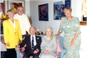
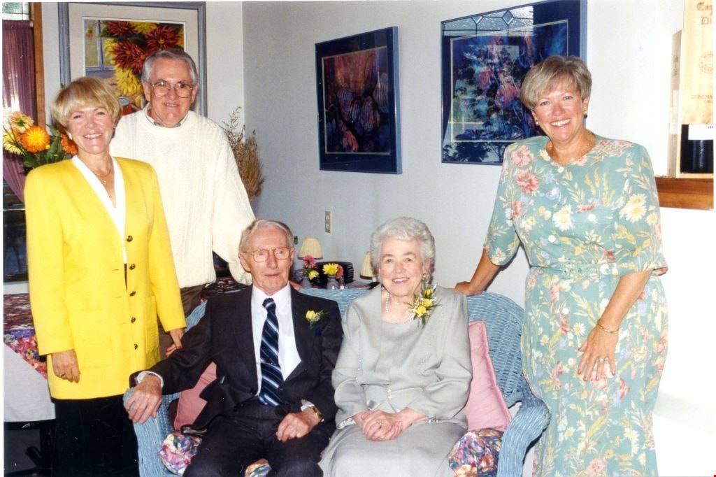
60th Wedding Anniversary
https://search.heritageburnaby.ca/link/museumdescription5167
- Repository
- Burnaby Village Museum
- Date
- 1995
- Collection/Fonds
- Waplington family fonds
- Description Level
- Item
- Physical Description
- 1 photograph : col. ; 10 x 15 cm
- Scope and Content
- Photograph of the Fleming clan celebrating the 60th Anniversary of Ray and Frances Fleming with their children Edith (Edie) Ehlers (nee Fleming), John (Jack) Fleming and Maureen Clayton (nee Fleming).
- Repository
- Burnaby Village Museum
- Collection/Fonds
- Waplington family fonds
- Description Level
- Item
- Physical Description
- 1 photograph : col. ; 10 x 15 cm
- Scope and Content
- Photograph of the Fleming clan celebrating the 60th Anniversary of Ray and Frances Fleming with their children Edith (Edie) Ehlers (nee Fleming), John (Jack) Fleming and Maureen Clayton (nee Fleming).
- Names
- Ehlers, Edith "Edie" Fleming
- Fleming, John "Jack" Reyland
- Clayton, Sara Maureen Fleming
- Fleming, John Reyland "Ray"
- Fleming, Frances "Fanny" Waplington
- Accession Code
- BV016.46.122
- Access Restriction
- No restrictions
- Reproduction Restriction
- May be restricted by third party rights
- Date
- 1995
- Media Type
- Photograph
- Scan Resolution
- 600
- Scan Date
- 13-Aug-2018
- Notes
- Title based on annotations in album
- Note in blue ink on verso of photograph reads: "The Fleming Clan / 60th Anniversary!"
- Photograph is part of Photograph album BV016.46.52
Images
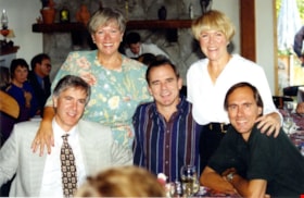
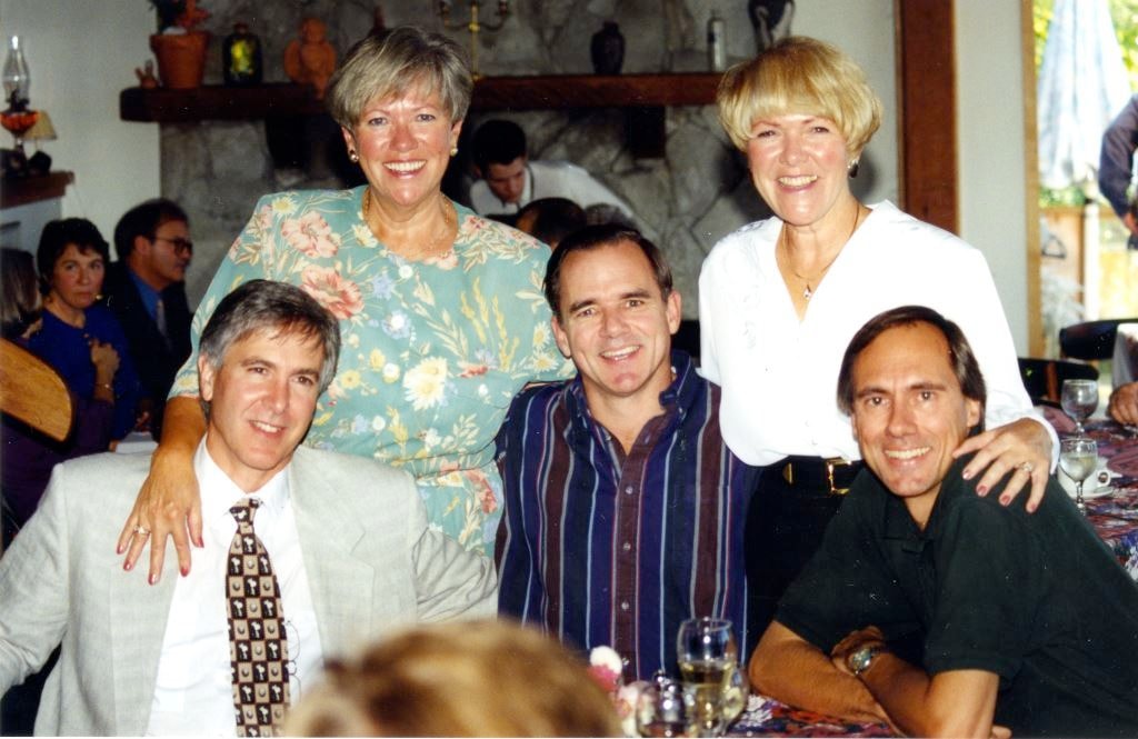
60th Wedding Anniversary
https://search.heritageburnaby.ca/link/museumdescription5168
- Repository
- Burnaby Village Museum
- Date
- 1995
- Collection/Fonds
- Waplington family fonds
- Description Level
- Item
- Physical Description
- 1 photograph : col. ; 10 x 15 cm
- Scope and Content
- Photograph of Brian Waplington, Maureen Clayton (nee Fleming), cousin Ray Ferguson, Edith (Edie) Ehners (nee Fleming) and cousin Norm Ferguson at the 60th Anniversary celebration of Ray and Frances Fleming.
- Repository
- Burnaby Village Museum
- Collection/Fonds
- Waplington family fonds
- Description Level
- Item
- Physical Description
- 1 photograph : col. ; 10 x 15 cm
- Scope and Content
- Photograph of Brian Waplington, Maureen Clayton (nee Fleming), cousin Ray Ferguson, Edith (Edie) Ehners (nee Fleming) and cousin Norm Ferguson at the 60th Anniversary celebration of Ray and Frances Fleming.
- Names
- Ehlers, Edith "Edie" Fleming
- Fleming, John "Jack" Reyland
- Clayton, Sara Maureen Fleming
- Waplington, Brian
- Ferguson, Ray
- Ferguson, Norman
- Accession Code
- BV016.46.123
- Access Restriction
- No restrictions
- Reproduction Restriction
- May be restricted by third party rights
- Date
- 1995
- Media Type
- Photograph
- Scan Resolution
- 600
- Scan Date
- 13-Aug-2018
- Notes
- Title based on annotations in album
- Photograph is part of Photograph album BV016.46.52
Images
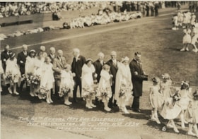
The 65th May Day celebration in New Westminster
https://search.heritageburnaby.ca/link/museumdescription822
- Repository
- Burnaby Village Museum
- Date
- May 11, 1934
- Collection/Fonds
- Burnaby Village Museum Photograph collection
- Description Level
- Item
- Physical Description
- 1 photograph : sepia ; 12.5 x 17.5 cm
- Scope and Content
- Photograph of the parade of May Queen Suite at the May Day celebration in New Westminster in 1934. Leading the parade are flower girls, and following them are the girls in the suite, each escorted by a man in a suit. In the background, there are crowds of people gathered to watch the parade. Ins…
- Repository
- Burnaby Village Museum
- Collection/Fonds
- Burnaby Village Museum Photograph collection
- Description Level
- Item
- Physical Description
- 1 photograph : sepia ; 12.5 x 17.5 cm
- Scope and Content
- Photograph of the parade of May Queen Suite at the May Day celebration in New Westminster in 1934. Leading the parade are flower girls, and following them are the girls in the suite, each escorted by a man in a suit. In the background, there are crowds of people gathered to watch the parade. Inscribed in the negative and printed on the photograph, bottom front "The 65th May Day Celebration / New Westminster, B.C., May 11th, 1934 / Stride Studio Photos / 6."
- Subjects
- Events - May Day
- Accession Code
- HV976.143.2
- Access Restriction
- No restrictions
- Reproduction Restriction
- No known restrictions
- Date
- May 11, 1934
- Media Type
- Photograph
- Scan Resolution
- 600
- Scan Date
- 2023-06-27
- Photographer
- Stride, Charles Edgar
- Notes
- The photographs in the accession HV976.143 are thought to be by the Stride studio, as the donor indicated in her letter that the Stride family were personal friends of her great-aunt and her husband, who resided in Edmonds. She wrote that she received a picture of the New Westminster or Burnaby May Day celebrations each year.
Images

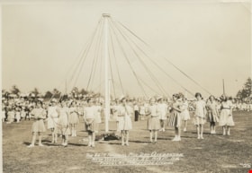
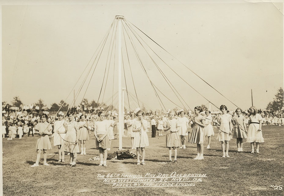
The 66th May Day Celebration
https://search.heritageburnaby.ca/link/museumdescription827
- Repository
- Burnaby Village Museum
- Date
- May 1, 1936
- Collection/Fonds
- Burnaby Village Museum Photograph collection
- Description Level
- Item
- Physical Description
- 1 photograph : sepia ; 12.2 x 17.3 cm
- Scope and Content
- Photograph of a group of girls each holding a ribbon from the Maypole in her hands, getting ready for the Maypole dance at the May Day Celebration in New Westminster in 1936. Most of the girls are wearing white dresses, some are in a skirt and blouse, and most wear strap shoes. There is a crowd o…
- Repository
- Burnaby Village Museum
- Collection/Fonds
- Burnaby Village Museum Photograph collection
- Description Level
- Item
- Physical Description
- 1 photograph : sepia ; 12.2 x 17.3 cm
- Scope and Content
- Photograph of a group of girls each holding a ribbon from the Maypole in her hands, getting ready for the Maypole dance at the May Day Celebration in New Westminster in 1936. Most of the girls are wearing white dresses, some are in a skirt and blouse, and most wear strap shoes. There is a crowd of people gathered behind them to watch the dance. Inscribed in the negative and printed on the photograph, bottom front: "The 66th May Day Celebration / New Westminster, B.C., May 1st, 1936 / Photos by the Stride Studios / #28."
- Geographic Access
- New Westminster
- Accession Code
- HV976.143.7
- Access Restriction
- No restrictions
- Reproduction Restriction
- No known restrictions
- Date
- May 1, 1936
- Media Type
- Photograph
- Scan Resolution
- 600
- Scan Date
- 2023-06-27
- Photographer
- Stride, Charles Edgar
- Notes
- The photographs in the accession HV976.143 are thought to be by the Stride studio, as the donor indicated in her letter that the Stride family were personal friends of her great-aunt and her husband, who resided in Edmonds. She wrote that she received a picture of the New Westminster or Burnaby May Day celebrations each year.
Images
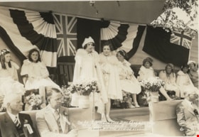
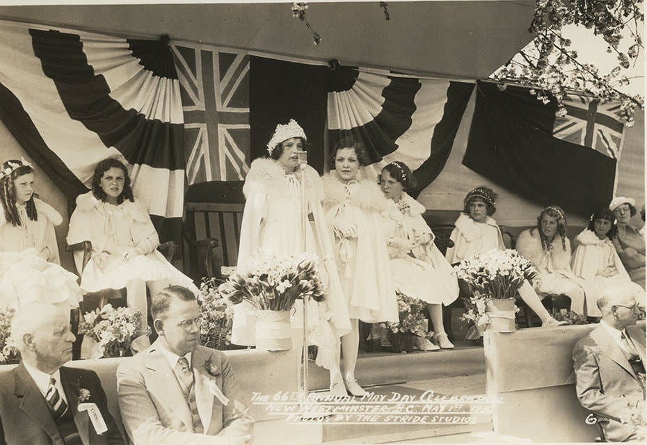
The 66th May Day celebration in New Westminster
https://search.heritageburnaby.ca/link/museumdescription823
- Repository
- Burnaby Village Museum
- Date
- May 1, 1936
- Collection/Fonds
- Burnaby Village Museum Photograph collection
- Description Level
- Item
- Physical Description
- 1 photograph : sepia ; 12.2 x 17.4 cm
- Scope and Content
- Photograph of the May Queen Suite on stage at the May Day Celebrations in New Westminster. The May Queen with a crown of flowers is at the microphone set up on the stage with her first maid standing beside her. The other girls in the Suite are seated on their chairs on the stage. Men in suits with …
- Repository
- Burnaby Village Museum
- Collection/Fonds
- Burnaby Village Museum Photograph collection
- Description Level
- Item
- Physical Description
- 1 photograph : sepia ; 12.2 x 17.4 cm
- Scope and Content
- Photograph of the May Queen Suite on stage at the May Day Celebrations in New Westminster. The May Queen with a crown of flowers is at the microphone set up on the stage with her first maid standing beside her. The other girls in the Suite are seated on their chairs on the stage. Men in suits with a flower and ribbon on their lapel are seated in front of the stage. There is a Union Jack hung in the centre of the wall behind the stage. Inscribed in the negative and printed on the photograph, bottom front: "The 66th May Day Celebration / New Westminster, B.C., May 1st, 1936 / Photos by the Stride Studios / 6."
- Subjects
- Symbols - Flags
- Events - May Day
- Accession Code
- HV976.143.3
- Access Restriction
- No restrictions
- Reproduction Restriction
- No known restrictions
- Date
- May 1, 1936
- Media Type
- Photograph
- Scan Resolution
- 600
- Scan Date
- 2023-06-27
- Photographer
- Stride, Charles Edgar
- Notes
- The photographs in the accession HV976.143 are thought to be by the Stride studio, as the donor indicated in her letter that the Stride family were personal friends of her great-aunt and her husband, who resided in Edmonds. She wrote that she received a picture of the New Westminster or Burnaby May Day celebrations each year.
Images
75 years, 1926-2001, Royal Oak Community Church : committed to Christ & community
https://search.heritageburnaby.ca/link/museumlibrary5444
- Repository
- Burnaby Village Museum
- Collection
- Reference Collection
- Material Type
- Book
- Call Number
- 971 ROC
- Place of Publication
- [Burnaby, B.C.]
- Publisher
- Royal Oak Community Church
- Publication Date
- 2001
- Physical Description
- [7] p. : ill. ; 22 cm.
- Library Subject (LOC)
- Church anniversaries
- Church buildings
- Church history
- Notes
- Formerly, Alta Vista Baptist Chruch--p. [1].