Narrow Results By
Subject
- Aerial Photographs 1
- Buildings - Commercial - Stores 1
- Buildings - Residential - Houses 3
- Celebrations - Jubilee 1
- Geographic Features - Lakes and Ponds 3
- Geographic Features - Roads 1
- Geographic Features - Sidewalks 1
- Land Clearing 1
- Occupations - Clergy 1
- Occupations - Clerks 1
- Sports - Swimming 2
![Aerial photograph of Douglas Road and Sperling Avenue, [1938] thumbnail](/media/hpo/_Data/_BVM_Images/1990/199200470001.jpg?width=280)
Aerial photograph of Douglas Road and Sperling Avenue
https://search.heritageburnaby.ca/link/museumdescription1165
- Repository
- Burnaby Village Museum
- Date
- [1938]
- Collection/Fonds
- Burnaby Village Museum Photograph collection
- Description Level
- Item
- Physical Description
- 1 photograph : b&w ; 19 x 24 cm
- Scope and Content
- Aerial photograph of the area surrounding Douglas Road and Sperling Avenue.
- Repository
- Burnaby Village Museum
- Collection/Fonds
- Burnaby Village Museum Photograph collection
- Description Level
- Item
- Physical Description
- 1 photograph : b&w ; 19 x 24 cm
- Scope and Content
- Aerial photograph of the area surrounding Douglas Road and Sperling Avenue.
- Subjects
- Aerial Photographs
- Geographic Access
- Douglas Road
- Sperling Avenue
- Accession Code
- BV992.47.1
- Access Restriction
- No restrictions
- Date
- [1938]
- Media Type
- Photograph
- Historic Neighbourhood
- Burnaby Lake (Historic Neighbourhood)
- Planning Study Area
- Morley-Buckingham Area
- Scan Resolution
- 600
- Scan Date
- 01-Jun-09
- Scale
- 100
- Notes
- Title based on contents of photograph
- Notes on verso of photograph read: "Burnaby Image Bank #532" and "DOUGLAS ROAD AND SPERLING c. 1938"
- Stamp on verso of photograph reads: "Copyright Simon Fraser/ University Archives"
Images
![Aerial photograph of Douglas Road and Sperling Avenue, [1938] thumbnail](/media/hpo/_Data/_BVM_Images/1990/199200470001.jpg)
![Claude Hill in front of log pile, [1897] thumbnail](/media/hpo/_Data/_BVM_Images/1973/1973_0040_0002_001.jpg?width=280)
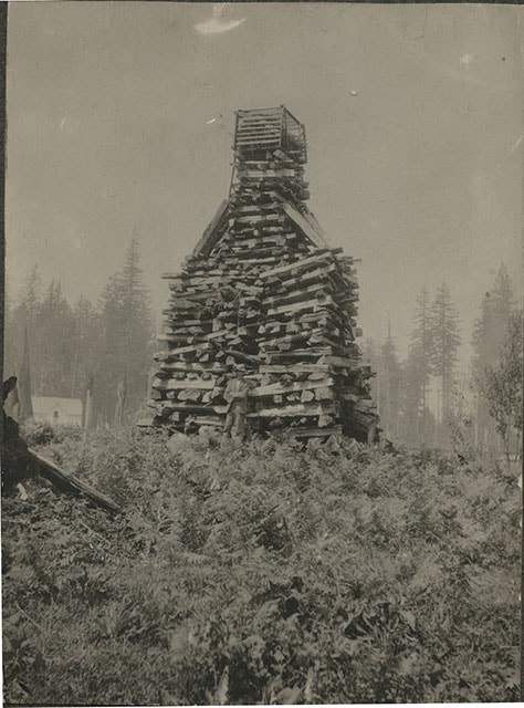
Claude Hill in front of log pile
https://search.heritageburnaby.ca/link/museumdescription989
- Repository
- Burnaby Village Museum
- Date
- [1897]
- Collection/Fonds
- Burnaby Village Museum Photograph collection
- Description Level
- Item
- Physical Description
- 1 photograph : sepia ; 9.6 x 7.1 cm mounted on cardboard 14.9 x 12.5 cm
- Scope and Content
- Photograph of a large stack of wood prepared for a bonfire on a hill. The bonfire stack is towering over a man who stands in front of it with his arms crossed and wearing a hat. There is a house seen in the background to the left of the photograph. The photograph is identified by the acquisition…
- Repository
- Burnaby Village Museum
- Collection/Fonds
- Burnaby Village Museum Photograph collection
- Description Level
- Item
- Physical Description
- 1 photograph : sepia ; 9.6 x 7.1 cm mounted on cardboard 14.9 x 12.5 cm
- Scope and Content
- Photograph of a large stack of wood prepared for a bonfire on a hill. The bonfire stack is towering over a man who stands in front of it with his arms crossed and wearing a hat. There is a house seen in the background to the left of the photograph. The photograph is identified by the acquisition record and inscription on the back as Queen Victoria's Jubilee bonfire. There is a discrepancy in the records as to who the man is. Some have identified him as Bernard Hill, others, as Mr. L.C. Hill. An annotation on th back of the photo reads, "1897/ Queen Victorias Jubilee/ Bonfire prepared by Mr LC Hill/ just above what is now Deer/ Lake Ave and below the/ present Centennial Pavilion."
- Subjects
- Celebrations - Jubilee
- Geographic Access
- Deer Lake
- Accession Code
- HV973.40.2
- Access Restriction
- No restrictions
- Reproduction Restriction
- No known restrictions
- Date
- [1897]
- Media Type
- Photograph
- Historic Neighbourhood
- Burnaby Lake (Historic Neighbourhood)
- Related Material
- For another photograph of the bonfire prepared by L. C. Hill, see photograph HV976.139.49
- Scan Resolution
- 600
- Scan Date
- 2023-05-09
- Scale
- 100
- Notes
- Title based on contents of photograph
Images
![Claude Hill in front of log pile, [1897] thumbnail](/media/hpo/_Data/_BVM_Images/1973/1973_0040_0002_001.jpg)
![Climbing onto a diving platform, [between 1925 and 1939] thumbnail](/media/hpo/_Data/_BVM_Images/2000/200400220005.jpg?width=280)
Climbing onto a diving platform
https://search.heritageburnaby.ca/link/museumdescription1753
- Repository
- Burnaby Village Museum
- Date
- [between 1925 and 1939]
- Collection/Fonds
- Burnaby Village Museum Photograph collection
- Description Level
- Item
- Physical Description
- 1 photograph : sepia ; 13 x 8 cm
- Scope and Content
- Photograph of an unidentified woman in a tank-style swimsuit climbing onto a wooden diving platform in Deer Lake.
- Repository
- Burnaby Village Museum
- Collection/Fonds
- Burnaby Village Museum Photograph collection
- Description Level
- Item
- Physical Description
- 1 photograph : sepia ; 13 x 8 cm
- Scope and Content
- Photograph of an unidentified woman in a tank-style swimsuit climbing onto a wooden diving platform in Deer Lake.
- Geographic Access
- Deer Lake
- Accession Code
- BV004.22.5
- Access Restriction
- No restrictions
- Reproduction Restriction
- No known restrictions
- Date
- [between 1925 and 1939]
- Media Type
- Photograph
- Historic Neighbourhood
- Burnaby Lake (Historic Neighbourhood)
- Planning Study Area
- Morley-Buckingham Area
- Scan Resolution
- 600
- Scan Date
- 09-Jun-09
- Scale
- 100
- Notes
- Title based on contents of photograph
Images
![Climbing onto a diving platform, [between 1925 and 1939] thumbnail](/media/hpo/_Data/_BVM_Images/2000/200400220005.jpg)
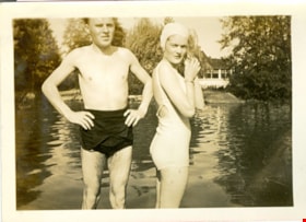
Colin and Wilma
https://search.heritageburnaby.ca/link/museumdescription2714
- Repository
- Burnaby Village Museum
- Date
- July 1937
- Collection/Fonds
- Hawkshaw family fonds
- Description Level
- Item
- Physical Description
- 1 photograph : sepia ; 5.5 x 8 cm
- Scope and Content
- Photograph of Colin and Wilma standing in swimsuits at the water's edge at Deer Lake.
- Repository
- Burnaby Village Museum
- Collection/Fonds
- Hawkshaw family fonds
- Description Level
- Item
- Physical Description
- 1 photograph : sepia ; 5.5 x 8 cm
- Scope and Content
- Photograph of Colin and Wilma standing in swimsuits at the water's edge at Deer Lake.
- Geographic Access
- Deer Lake
- Accession Code
- BV996.6.155
- Access Restriction
- No restrictions
- Reproduction Restriction
- No known restrictions
- Date
- July 1937
- Media Type
- Photograph
- Scan Resolution
- 600
- Scan Date
- 2/9/2010
- Scale
- 100
- Notes
- Title based on contents of photograph
- Caption for photograph reads: "Colin, Wilma"
- Photograph is part of photograph album BV996.6.1
Images

![Common Good Co-op Store, [1938] thumbnail](/media/hpo/_Data/_BVM_Images/1976/1976_0046_0001_001.jpg?width=280)
Common Good Co-op Store
https://search.heritageburnaby.ca/link/museumdescription735
- Repository
- Burnaby Village Museum
- Date
- [1938]
- Collection/Fonds
- Burnaby Village Museum Photograph collection
- Description Level
- Item
- Physical Description
- 1 photograph : sepia ; 6.8 x 11.2 cm
- Scope and Content
- Photograph of a man in an apron standing in front of a co-op store bearing the sign "C.G. Co-operative Association", otherwise known as the Army of the Common Good. Window displays include the goods he carries and advertising signs for Coca-Cola and Orange Crush are put up below the windows. In fro…
- Repository
- Burnaby Village Museum
- Collection/Fonds
- Burnaby Village Museum Photograph collection
- Description Level
- Item
- Physical Description
- 1 photograph : sepia ; 6.8 x 11.2 cm
- Material Details
- Inscribed in pencil, recto, b. "Co op store Douglas R." and in blue ink, verso, t. "Coop Store Douglas Road/ C.G. Co-op 1939", b. "Mr Love Mayor of/ store/ no 2", in blue ball point pen, l.l. "Main Store was at McKay station/ this is No 1 Branch store" stamped on verso, c. "VANCOUVER/ DRUG CO. LTD/ SEP 12 1938/ Nu-Gloss"
- Scope and Content
- Photograph of a man in an apron standing in front of a co-op store bearing the sign "C.G. Co-operative Association", otherwise known as the Army of the Common Good. Window displays include the goods he carries and advertising signs for Coca-Cola and Orange Crush are put up below the windows. In front of the store is wood plank sidewalk.
- Geographic Access
- Douglas Road
- Accession Code
- HV976.46.1
- Access Restriction
- No restrictions
- Reproduction Restriction
- No known restrictions
- Date
- [1938]
- Media Type
- Photograph
- Scan Resolution
- 600
- Scan Date
- 2023-06-20
- Notes
- Title based on caption of photograph
Images
![Common Good Co-op Store, [1938] thumbnail](/media/hpo/_Data/_BVM_Images/1976/1976_0046_0001_001.jpg)
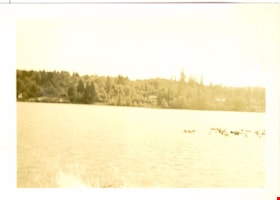
Deer Lake
https://search.heritageburnaby.ca/link/museumdescription2716
- Repository
- Burnaby Village Museum
- Date
- July 1937
- Collection/Fonds
- Hawkshaw family fonds
- Description Level
- Item
- Physical Description
- 1 photograph : sepia ; 5.5 x 8 cm
- Scope and Content
- Photograph of Deer Lake.
- Repository
- Burnaby Village Museum
- Collection/Fonds
- Hawkshaw family fonds
- Description Level
- Item
- Physical Description
- 1 photograph : sepia ; 5.5 x 8 cm
- Scope and Content
- Photograph of Deer Lake.
- Geographic Access
- Deer Lake
- Accession Code
- BV996.6.157
- Access Restriction
- No restrictions
- Reproduction Restriction
- No known restrictions
- Date
- July 1937
- Media Type
- Photograph
- Scan Resolution
- 600
- Scan Date
- 2/9/2010
- Scale
- 100
- Notes
- Title based on contents of photograph
- Caption for photograph reads: "Deer Lake"
- Photograph is part of photograph album BV996.6.1
Images

![Douglas Road, [1897] (date of original), copied 1978 thumbnail](/media/hpo/_Data/_BVM_Images/1978/1978_0001_0001_001.jpg?width=280)
Douglas Road
https://search.heritageburnaby.ca/link/museumdescription447
- Repository
- Burnaby Village Museum
- Date
- [1897] (date of original), copied 1978
- Collection/Fonds
- Burnaby Village Museum Photograph collection
- Description Level
- Item
- Physical Description
- 1 photograph : b&w ; 20.2 x 25.2 cm print
- Scope and Content
- Photograph of Douglas Road (later renamed in part Canada Way), near Stanley Street. To the right is the Sprott family property, where a few wooden buildings are visible in the cleared area. Charles Sprott, head of the Sprott family, was an important Burnaby politician who was continuously elected t…
- Repository
- Burnaby Village Museum
- Collection/Fonds
- Burnaby Village Museum Photograph collection
- Description Level
- Item
- Physical Description
- 1 photograph : b&w ; 20.2 x 25.2 cm print
- Scope and Content
- Photograph of Douglas Road (later renamed in part Canada Way), near Stanley Street. To the right is the Sprott family property, where a few wooden buildings are visible in the cleared area. Charles Sprott, head of the Sprott family, was an important Burnaby politician who was continuously elected to serve in the municiality as councillor from 1895 to 1903 and as Reeve from 1904 to 1905.
- Subjects
- Geographic Features - Roads
- Land Clearing
- Geographic Access
- Douglas Road
- Canada Way
- Stanley Street
- Accession Code
- HV978.1.1
- Access Restriction
- No restrictions
- Reproduction Restriction
- No known restrictions
- Date
- [1897] (date of original), copied 1978
- Media Type
- Photograph
- Historic Neighbourhood
- Burnaby Lake (Historic Neighbourhood)
- Planning Study Area
- Lakeview-Mayfield Area
- Scan Resolution
- 600
- Scan Date
- 2023-07-25
- Notes
- Title based on contents of photograph
Images
![Douglas Road, [1897] (date of original), copied 1978 thumbnail](/media/hpo/_Data/_BVM_Images/1978/1978_0001_0001_001.jpg)
![Eight Clergymen at Saint Theresa's Roman Catholic Church, [192-] thumbnail](/media/hpo/_Data/_BVM_Images/1975/1975_0105_0003_001.jpg?width=280)
Eight Clergymen at Saint Theresa's Roman Catholic Church
https://search.heritageburnaby.ca/link/museumdescription904
- Repository
- Burnaby Village Museum
- Date
- [192-]
- Collection/Fonds
- Burnaby Village Museum Photograph collection
- Description Level
- Item
- Physical Description
- 1 photograph : b&w ; 5.7 x 8.2 cm
- Scope and Content
- Photograph of eight unidentified clergymen posed outside in front of a brick building. Four are standing and the other four are seated in front of the standing men. On the right side of the photo, there is a sign that reads, "In Your Prayers / Kindly Remember." The location has been identified as…
- Repository
- Burnaby Village Museum
- Collection/Fonds
- Burnaby Village Museum Photograph collection
- Description Level
- Item
- Physical Description
- 1 photograph : b&w ; 5.7 x 8.2 cm
- Scope and Content
- Photograph of eight unidentified clergymen posed outside in front of a brick building. Four are standing and the other four are seated in front of the standing men. On the right side of the photo, there is a sign that reads, "In Your Prayers / Kindly Remember." The location has been identified as Saint Theresa's Roman Catholic Church. The church was located at the southeast corner of Canada Way and Laurel Street. Built in 1929, it was torn down in 1974, and a new church, St.Theresa's Parish, was built across the street.
- Subjects
- Occupations - Clergy
- Geographic Access
- Douglas Road
- Canada Way
- Laurel Street
- Accession Code
- HV975.105.3
- Access Restriction
- No restrictions
- Reproduction Restriction
- May be restricted by third party rights
- Date
- [192-]
- Media Type
- Photograph
- Historic Neighbourhood
- Burnaby Lake (Historic Neighbourhood)
- Planning Study Area
- Douglas-Gilpin Area
- Scan Resolution
- 600
- Scan Date
- 2023-06-13
- Notes
- Title based on contents of photograph
Images
![Eight Clergymen at Saint Theresa's Roman Catholic Church, [192-] thumbnail](/media/hpo/_Data/_BVM_Images/1975/1975_0105_0003_001.jpg)
![McWilliams house, [193-] thumbnail](/media/hpo/_Data/_BVM_Images/1990/199400220003.jpg?width=280)
McWilliams house
https://search.heritageburnaby.ca/link/museumdescription1196
- Repository
- Burnaby Village Museum
- Date
- [193-]
- Collection/Fonds
- E.W. Bateman family fonds
- Description Level
- Item
- Physical Description
- 1 photograph : sepia ; 6.5 x 12 cm
- Scope and Content
- Photograph of the McWilliams house on Douglas Road. Mamie Bateman McWilliams lived here with her family and is the daughter of Edwin Wettenhall Bateman, who built Elworth (directly across the street).
- Repository
- Burnaby Village Museum
- Collection/Fonds
- E.W. Bateman family fonds
- Description Level
- Item
- Physical Description
- 1 photograph : sepia ; 6.5 x 12 cm
- Scope and Content
- Photograph of the McWilliams house on Douglas Road. Mamie Bateman McWilliams lived here with her family and is the daughter of Edwin Wettenhall Bateman, who built Elworth (directly across the street).
- Subjects
- Buildings - Residential - Houses
- Geographic Access
- Douglas Road
- Accession Code
- BV994.22.3
- Access Restriction
- No restrictions
- Reproduction Restriction
- No known restrictions
- Date
- [193-]
- Media Type
- Photograph
- Historic Neighbourhood
- Burnaby Lake (Historic Neighbourhood)
- Planning Study Area
- Morley-Buckingham Area
- Scan Resolution
- 600
- Scan Date
- 01-Jun-09
- Scale
- 100
- Notes
- Title based on contents of photograph
- Stamp on verso of photograph reads: "Better Pictures/ NuGloss/ PHOTO FINISH/ Vancouver Drug Co."
Images
![McWilliams house, [193-] thumbnail](/media/hpo/_Data/_BVM_Images/1990/199400220003.jpg)
![McWilliams house, [193-] thumbnail](/media/hpo/_Data/_BVM_Images/1990/199400220001.jpg?width=280)
McWilliams house
https://search.heritageburnaby.ca/link/museumdescription3127
- Repository
- Burnaby Village Museum
- Date
- [193-]
- Collection/Fonds
- E.W. Bateman family fonds
- Description Level
- Item
- Physical Description
- 1 photograph : b&w ; 5 x 8 cm
- Scope and Content
- Photograph of the McWilliams house on Douglas Road. The house has a large patio area with a gravel road in front and a wood fence behind. A boy is sitting with a dog on the front steps. Mamie Bateman McWilliams lived here with her family, and is the daughter of Edwin Wettenhall Bateman, who built E…
- Repository
- Burnaby Village Museum
- Collection/Fonds
- E.W. Bateman family fonds
- Description Level
- Item
- Physical Description
- 1 photograph : b&w ; 5 x 8 cm
- Scope and Content
- Photograph of the McWilliams house on Douglas Road. The house has a large patio area with a gravel road in front and a wood fence behind. A boy is sitting with a dog on the front steps. Mamie Bateman McWilliams lived here with her family, and is the daughter of Edwin Wettenhall Bateman, who built Elworth (directly across the street).
- Subjects
- Buildings - Residential - Houses
- Geographic Access
- Douglas Road
- Accession Code
- BV994.22.1
- Access Restriction
- No restrictions
- Reproduction Restriction
- No known restrictions
- Date
- [193-]
- Media Type
- Photograph
- Historic Neighbourhood
- Burnaby Lake (Historic Neighbourhood)
- Planning Study Area
- Morley-Buckingham Area
- Scan Resolution
- 600
- Scan Date
- 01-Jun-09
- Scale
- 100
- Notes
- Title based on contents of photograph
Images
![McWilliams house, [193-] thumbnail](/media/hpo/_Data/_BVM_Images/1990/199400220001.jpg)
![McWilliams house, [193-] thumbnail](/media/hpo/_Data/_BVM_Images/1990/199400220002.jpg?width=280)
McWilliams house
https://search.heritageburnaby.ca/link/museumdescription3128
- Repository
- Burnaby Village Museum
- Date
- [193-]
- Collection/Fonds
- E.W. Bateman family fonds
- Description Level
- Item
- Physical Description
- 1 photograph : b&w ; 6 x 10.5 cm
- Scope and Content
- Photograph of the McWilliams house on Douglas Road. Mamie Bateman McWilliams lived here with her family and is the daughter of Edwin Wettenhall Bateman, who built Elworth (directly across the street).
- Repository
- Burnaby Village Museum
- Collection/Fonds
- E.W. Bateman family fonds
- Description Level
- Item
- Physical Description
- 1 photograph : b&w ; 6 x 10.5 cm
- Scope and Content
- Photograph of the McWilliams house on Douglas Road. Mamie Bateman McWilliams lived here with her family and is the daughter of Edwin Wettenhall Bateman, who built Elworth (directly across the street).
- Subjects
- Buildings - Residential - Houses
- Geographic Access
- Douglas Road
- Accession Code
- BV994.22.2
- Access Restriction
- No restrictions
- Reproduction Restriction
- No known restrictions
- Date
- [193-]
- Media Type
- Photograph
- Historic Neighbourhood
- Burnaby Lake (Historic Neighbourhood)
- Planning Study Area
- Morley-Buckingham Area
- Scan Resolution
- 600
- Scan Date
- 01-Jun-09
- Scale
- 100
- Notes
- Title based on contents of photograph
Images
![McWilliams house, [193-] thumbnail](/media/hpo/_Data/_BVM_Images/1990/199400220002.jpg)