Narrow Results By
Creator
- Arnold, Frank H. 1
- Banning, Kendall, 1879-1944 1
- Bingham, Alfred "Alf" 2
- Blake, Frederick "Fred" 2
- Bridgman's Studio Limited 3
- British Columbia Underwriters' Association 10
- Brown, Cice Chandler 1
- Bryce, Henry G. 1
- Bullen, Harry Elder 1
- Burnaby Village Museum 4
- Burnett & McGugan, Engineers and Surveyors 3
- Campbell Studios Limited 1
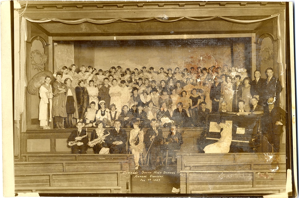
South Burnaby High School Annual concert
https://search.heritageburnaby.ca/link/museumdescription3881
- Repository
- Burnaby Village Museum
- Date
- 7 Feb. 1927
- Collection/Fonds
- Burnaby Village Museum Photograph collection
- Description Level
- Item
- Physical Description
- 1 photograph : sepia ; 26 x 17.5 cm
- Scope and Content
- Photograph of students and participants in the Burnaby South High School annual concert held at the Burnaby Public Hall located next to the Municipal Hall at Edmonds and Kingsway. Six musicians are seated in front of the stage and five rows of performers are arranged on stage. Elinor Winter is iden…
- Repository
- Burnaby Village Museum
- Collection/Fonds
- Burnaby Village Museum Photograph collection
- Description Level
- Item
- Physical Description
- 1 photograph : sepia ; 26 x 17.5 cm
- Scope and Content
- Photograph of students and participants in the Burnaby South High School annual concert held at the Burnaby Public Hall located next to the Municipal Hall at Edmonds and Kingsway. Six musicians are seated in front of the stage and five rows of performers are arranged on stage. Elinor Winter is identified sitting second from the left in the front row. "Burnaby South High School / Annual Concert / Feb. 7th 1927" and "Stuart Thomson / Vancouver / B.C." printed in image at center of bottom and at the lower right corner.
- Subjects
- Performances - Concerts
- Geographic Access
- Kingsway
- Street Address
- 7252 Kingsway
- Accession Code
- BV008.59.27
- Access Restriction
- No restrictions
- Reproduction Restriction
- No known restrictions
- Date
- 7 Feb. 1927
- Media Type
- Photograph
- Historic Neighbourhood
- Edmonds (Historic Neighbourhood)
- Planning Study Area
- Stride Avenue Area
- Related Material
- Similar photograph as City of Burnaby Archives Item no. 485-063
- Scan Resolution
- 600
- Scan Date
- 2022-03-08
- Photographer
- Thomson, Stuart
- Notes
- Title based on contents of photograph
- Note in white on bottom of photograph reads: "Burnaby South High School / Annual Concert / Feb. 7th 1927"_"Stuart Thomson / Vancouver / B.C."
- Handwritten note in pencil on verso of photograph reads: "Elinor May. / I think Mom is / first row on stage - / Horn pipe Costume"
Images
![Old Curly on a barge, [1927] (date of original), copied 2016 thumbnail](/media/hpo/_Data/_BVM_Images/2016/201600520006_001.jpg?width=280)
Old Curly on a barge
https://search.heritageburnaby.ca/link/museumdescription4042
- Repository
- Burnaby Village Museum
- Date
- [1927] (date of original), copied 2016
- Collection/Fonds
- Robinson-Surgenor collection
- Description Level
- Item
- Physical Description
- 1 photograph (tiff) : b&w ; 600 dpi
- Scope and Content
- Photograph of the steam locomotive known as "Old Curly" secured on a barge bound for Vancouver. There is an unidentified man sitting at the front of the locomotive. Water and shoreline are visible in the background. Text on the back of BV016.52.5 reads: "Curly & Old Bones both due for the Bone Yard…
- Repository
- Burnaby Village Museum
- Collection/Fonds
- Robinson-Surgenor collection
- Description Level
- Item
- Physical Description
- 1 photograph (tiff) : b&w ; 600 dpi
- Scope and Content
- Photograph of the steam locomotive known as "Old Curly" secured on a barge bound for Vancouver. There is an unidentified man sitting at the front of the locomotive. Water and shoreline are visible in the background. Text on the back of BV016.52.5 reads: "Curly & Old Bones both due for the Bone Yard". This was written by the donor's grandmother.
- Geographic Access
- Vancouver
- Accession Code
- BV016.52.6
- Access Restriction
- Restricted access
- Reproduction Restriction
- May be restricted by third party rights
- Date
- [1927] (date of original), copied 2016
- Media Type
- Photograph
- Scan Resolution
- 600
- Scan Date
- 10-Mar-15
- Scale
- 100
- Notes
- Title based on contents of photograph
- Scan of photograph negative
Images
![Old Curly on a barge, [1927] (date of original), copied 2016 thumbnail](/media/hpo/_Data/_BVM_Images/2016/201600520006_001.jpg)
![Studio portait of Annie, Maida and Laura Jung, [between 1927 and 1929] thumbnail](/media/hpo/_Data/_BVM_Images/2017/2017_0024_0006_001.jpg?width=280)
Studio portait of Annie, Maida and Laura Jung
https://search.heritageburnaby.ca/link/museumdescription4053
- Repository
- Burnaby Village Museum
- Date
- [between 1927 and 1929]
- Collection/Fonds
- Julie Lee and Cecil Lee family fonds
- Description Level
- Item
- Physical Description
- 1 photograph (tiff) : b&w ; 800 dpi
- Scope and Content
- Photograph of the three Jung sisters posing on a wicker sofa. From left to right: Annie (Suey Kin), Maida (Suey Fong), Laura (Suey Ying Jung).
- Repository
- Burnaby Village Museum
- Collection/Fonds
- Julie Lee and Cecil Lee family fonds
- Description Level
- Item
- Physical Description
- 1 photograph (tiff) : b&w ; 800 dpi
- Scope and Content
- Photograph of the three Jung sisters posing on a wicker sofa. From left to right: Annie (Suey Kin), Maida (Suey Fong), Laura (Suey Ying Jung).
- Subjects
- Persons - Chinese Canadians
- Accession Code
- BV017.24.6
- Access Restriction
- No restrictions
- Reproduction Restriction
- No known restrictions
- Date
- [between 1927 and 1929]
- Media Type
- Photograph
- Scan Resolution
- 800
- Scan Date
- 01-Oct-2017
- Scale
- 100
- Photographer
- Wand, Cecil Bow
- Notes
- Title based on contents of photograph
- Embossed lettering in the bottom left corner of the photograph reads: "Wand"
Images
![Studio portait of Annie, Maida and Laura Jung, [between 1927 and 1929] thumbnail](/media/hpo/_Data/_BVM_Images/2017/2017_0024_0006_001.jpg)

Municipality of Burnaby - Volume XV and Volume XVIII
https://search.heritageburnaby.ca/link/museumdescription8680
- Repository
- Burnaby Village Museum
- Date
- May 1927
- Collection/Fonds
- Burnaby Village Museum Map collection
- Description Level
- File
- Physical Description
- 4 plans on 4 sheets : col. lithographic prints ; 63.5 x 53.5 cm folded to 53 x 31.5 cm
- Scope and Content
- File consists of four pages of plans removed from a bound book containing a series of fire insurance plans of the Municipality of Burnaby. The first two pages are numbered "A" and "B" and are key plans from "GREATER VANCOUVER B.C. / VOLUME XV / Surveyed _ May 1927 / MUNICIPALITY OF / BURNABY", "PLA…
- Repository
- Burnaby Village Museum
- Collection/Fonds
- Burnaby Village Museum Map collection
- Description Level
- File
- Physical Description
- 4 plans on 4 sheets : col. lithographic prints ; 63.5 x 53.5 cm folded to 53 x 31.5 cm
- Material Details
- Scales [1:1200] and [1:6000]
- Scope and Content
- File consists of four pages of plans removed from a bound book containing a series of fire insurance plans of the Municipality of Burnaby. The first two pages are numbered "A" and "B" and are key plans from "GREATER VANCOUVER B.C. / VOLUME XV / Surveyed _ May 1927 / MUNICIPALITY OF / BURNABY", "PLAN DEPT. FIRE BRANCH _ B.C. INSURANCE UNDERWRITERS ASSN.". Key Plan "B" covers plans: 1505; 1506; 1512 to 1516; 1540 to 1544; 1550 to 1557 and District Lots: 129 to 132; 135 to 138; 205 to 208 and 215 to 218. Key Plan "A" covers plans: 1501 to 1504; 1507 to 1511; 1517 to 1525; 1531 to 1539; 1545 to 1550 and District Lots: 116 to 127 and 186 to 189. Plan "1806" is part of "GREATER VANCOUVER B.C. / VOLUME XVIII / Municipality of Burnaby / May, 1927" and covers District Lot 153. Plan "1807" is from "GREATER VANCOUVER B.C. / VOLUME XVIII / Municipality of Burnaby / May, 1927" and covers District Lots: 99,149 and 152.
- Responsibility
- British Columbia Underwriters' Association
- Accession Code
- HV972.111.2
- Access Restriction
- No restrictions
- Reproduction Restriction
- May be restricted by third party rights
- Date
- May 1927
- Media Type
- Cartographic Material
- Historic Neighbourhood
- Vancouver Heights (Historic Neighbourhood)
- Lochdale (Historic Neighbourhood)
- Capitol Hill (Historic Neighbourhood)
- Central Park (Historic Neighbourhood)
- Alta Vista (Historic Neighbourhood)
- Planning Study Area
- Burnaby Heights Area
- Sperling-Broadway Area
- Lochdale Area
- Parkcrest-Aubrey Area
- Westridge Area
- Willingdon Heights Area
- Capitol Hill Area
- Maywood Area
- Marlborough Area
- Scan Resolution
- 400
- Scan Date
- 2021-11-18
- Notes
- Title based on content of plans
- Scales are measured 1 inch = 100 feet and 1 inch = 500 feet
- See also BV987.1.70d for revised versions of plans
Zoomable Images


Municipality of Burnaby - Volume XV and Volume XVIII
https://search.heritageburnaby.ca/link/museumdescription8681
- Repository
- Burnaby Village Museum
- Date
- May 1927
- Collection/Fonds
- Burnaby Village Museum Map collection
- Description Level
- File
- Physical Description
- 4 plans on 4 sheets : col. lithographic prints, ms. annotations in blue ink ; 63.5 x 53.5 cm folded to 53 x 31.5 cm
- Scope and Content
- File consists of four pages of plans removed from a bound book containing a series of fire insurance plans of the Municipality of Burnaby. Plan "1507" and plan "1517" are from "GREATER VANCOUVER B.C. / VOLUME XV / Municipality of Burnaby / May, 1927". Plan "1507" covers District Lot 186 and plan "1…
- Repository
- Burnaby Village Museum
- Collection/Fonds
- Burnaby Village Museum Map collection
- Description Level
- File
- Physical Description
- 4 plans on 4 sheets : col. lithographic prints, ms. annotations in blue ink ; 63.5 x 53.5 cm folded to 53 x 31.5 cm
- Material Details
- Scale [1:600] and [1:1200]
- Scope and Content
- File consists of four pages of plans removed from a bound book containing a series of fire insurance plans of the Municipality of Burnaby. Plan "1507" and plan "1517" are from "GREATER VANCOUVER B.C. / VOLUME XV / Municipality of Burnaby / May, 1927". Plan "1507" covers District Lot 186 and plan "1517" covers District Lot 116. Plan "1804" and plan "1805" are from "GREATER VANCOUVER B.C. / VOLUME XVIII / Municipality of Burnaby / May, 1927". Plans "1804" and "1805" cover District Lot 153.
- Responsibility
- British Columbia Underwriters' Association
- Accession Code
- HV972.111.3
- Access Restriction
- No restrictions
- Reproduction Restriction
- May be restricted by third party rights
- Date
- May 1927
- Media Type
- Cartographic Material
- Historic Neighbourhood
- Central Park (Historic Neighbourhood)
- Vancouver Heights (Historic Neighbourhood)
- Planning Study Area
- Maywood Area
- Willingdon Heights Area
- Scan Resolution
- 400
- Scan Date
- 2021-11-18
- Notes
- Title based on content of plans
- See also BV987.1.70d for revised versions of plans
- Scale is measured 1 inch = 100 feet
Images


![Municipality of Burnaby - Volume XV and Volume XVIII, 1927-[1940] thumbnail](/media/hpo/_Data/_BVM_Artifacts/1972/1972_0111_0004_003.jpg?width=280)
Municipality of Burnaby - Volume XV and Volume XVIII
https://search.heritageburnaby.ca/link/museumdescription8682
- Repository
- Burnaby Village Museum
- Date
- 1927-[1940]
- Collection/Fonds
- Burnaby Village Museum Map collection
- Description Level
- File
- Physical Description
- 4 plans on 4 sheets: col. lithographic prints ; 63.5 x 53.5 cm folded to 53 x 31.5 cm
- Scope and Content
- File consists of four pages of plans removed from a bound book containing a series of fire insurance plans of the Municipality of Burnaby. Plan "1518" and "1519" are from "GREATER VANCOUVER B.C. / VOLUME XV / Municipality of Burnaby / May, 1927". Plan "1518" covers District Lot 116 and Plan "1519"…
- Repository
- Burnaby Village Museum
- Collection/Fonds
- Burnaby Village Museum Map collection
- Description Level
- File
- Physical Description
- 4 plans on 4 sheets: col. lithographic prints ; 63.5 x 53.5 cm folded to 53 x 31.5 cm
- Material Details
- Scale [1:600]
- Scope and Content
- File consists of four pages of plans removed from a bound book containing a series of fire insurance plans of the Municipality of Burnaby. Plan "1518" and "1519" are from "GREATER VANCOUVER B.C. / VOLUME XV / Municipality of Burnaby / May, 1927". Plan "1518" covers District Lot 116 and Plan "1519" covers District Lot 121. Plan "1802" and plan "1803" are from "GREATER VANCOUVER B.C. / VOLUME XVIII / Municipality of Burnaby / May, 1927". Both plans "1802" and "1803" cover District Lot 153.
- Responsibility
- British Columbia Underwriters' Association
- Accession Code
- HV972.111.4
- Access Restriction
- No restrictions
- Reproduction Restriction
- May be restricted by third party rights
- Date
- 1927-[1940]
- Media Type
- Cartographic Material
- Historic Neighbourhood
- Vancouver Heights (Historic Neighbourhood)
- Central Park (Historic Neighbourhood)
- Planning Study Area
- Willingdon Heights Area
- Marlborough Area
- Scan Resolution
- 400
- Scan Date
- 2021-11-18
- Notes
- Title based on content of plans
- See also BV987.1.70d for revised versions of plans
- Scale is measured 1 inch = 50 feet
- Contact Burnaby Village Museum to access plans 1518 and 1519 (these plans have revisions on top - date of revisions is uncertain)
Images
![Municipality of Burnaby - Volume XV and Volume XVIII, 1927-[1940] thumbnail](/media/hpo/_Data/_BVM_Artifacts/1972/1972_0111_0004_003.jpg)


Municipality of Burnaby - Volume XVIII and Volume XIX
https://search.heritageburnaby.ca/link/museumdescription8683
- Repository
- Burnaby Village Museum
- Date
- May 1927
- Collection/Fonds
- Burnaby Village Museum Map collection
- Description Level
- File
- Physical Description
- 2 plans on 2 sheets : col. lithographic prints ; 63.5 x 53.5 cm folded to 53 x 31.5 cm
- Scope and Content
- File consists of two pages of plans removed from a bound book containing a series of fire insurance plans of the Municipality of Burnaby. Plan "1832" is from "GREATER VANCOUVER B.C. / VOLUME XVIII / Municipality of Burnaby / May, 1927" and covers District Lots: 98 and 28. Plan "K" is part of a key …
- Repository
- Burnaby Village Museum
- Collection/Fonds
- Burnaby Village Museum Map collection
- Description Level
- File
- Physical Description
- 2 plans on 2 sheets : col. lithographic prints ; 63.5 x 53.5 cm folded to 53 x 31.5 cm
- Material Details
- Scale [1:1200] to [1:6000]
- Scope and Content
- File consists of two pages of plans removed from a bound book containing a series of fire insurance plans of the Municipality of Burnaby. Plan "1832" is from "GREATER VANCOUVER B.C. / VOLUME XVIII / Municipality of Burnaby / May, 1927" and covers District Lots: 98 and 28. Plan "K" is part of a key plan "GREATER VANCOUVER B.C. / Surveyed VOLUME XIX May 1927 / MUNICIPALITY OF / BURNABY / PLAN DEPT. British Columbia Ins. Underwriters Association / FIRE BRANCH / KEY PLAN", "Scale 500 FT = 1 INCH / FOR REPORT SEE VOL. XV" covering plans: 1901 to 1914 and District Lots: 161; 164 to 167; 155c; 155; 172 and 173.
- Responsibility
- British Columbia Underwriters' Association
- Accession Code
- HV972.111.5
- Access Restriction
- No restrictions
- Reproduction Restriction
- May be restricted by third party rights
- Date
- May 1927
- Media Type
- Cartographic Material
- Historic Neighbourhood
- East Burnaby (Historic Neighbourhood)
- Central Park (Historic Neighbourhood)
- Fraser Arm (Historic Neighbourhood)
- Alta Vista (Historic Neighbourhood)
- Planning Study Area
- Windsor Area
- Marlborough Area
- Second Street Area
- Big Bend Area
- Sussex-Nelson Area
- Scan Resolution
- 400
- Scan Date
- 2021-11-18
- Notes
- Title based on content of plans
- See also BV987.1.70d for revised versions of plans
- Scale is measured 1 inch = 500 feet
Zoomable Images


Municipality of Burnaby - Volume XVI and Volume XVII
https://search.heritageburnaby.ca/link/museumdescription8684
- Repository
- Burnaby Village Museum
- Date
- May 1927
- Collection/Fonds
- Burnaby Village Museum Map collection
- Description Level
- File
- Physical Description
- 4 plans on 4 sheets : col. lithographic prints ; 63.5 x 53.5 cm folded to 53 x 31.5 cm
- Scope and Content
- File consists of four pages of plans removed from a bound book containing a series of fire insurance plans of the Municipality of Burnaby. Page "D" is titled: "GREATER VANCOUVER B.C. / VOLUME XVI / Surveyed _ May 1927 / MUNICIPALITY OF / BURNABY / PLAN DEPT. FIRE BRANCH _ B.C. INSURANCE UNDERWRITE…
- Repository
- Burnaby Village Museum
- Collection/Fonds
- Burnaby Village Museum Map collection
- Description Level
- File
- Physical Description
- 4 plans on 4 sheets : col. lithographic prints ; 63.5 x 53.5 cm folded to 53 x 31.5 cm
- Material Details
- Scale [1:1200] and [1:6000]
- Scope and Content
- File consists of four pages of plans removed from a bound book containing a series of fire insurance plans of the Municipality of Burnaby. Page "D" is titled: "GREATER VANCOUVER B.C. / VOLUME XVI / Surveyed _ May 1927 / MUNICIPALITY OF / BURNABY / PLAN DEPT. FIRE BRANCH _ B.C. INSURANCE UNDERWRITERS ASSN." / KEY PLAN". Plans covered in this "Key Plan" are numbered 1601 to 1626, 1632 and 1651 covering District Lots: 15; 31; 100 to 102; 114; 141 to 144; 147 and 148; 209 to 214. Plan "E" is part of "GREATER VANCOUVER B.C. / VOLUME XVII / Municipality of Burnaby / May 1927" and covers plans: 1701 to 1705; 1711 to 1715; 1723 to 1727; 1729 to 1733; 1737 to 1742 and District Lots: 68 to 74; 80 to 84; 32 to 35 and 38 to 39. Plan marked "F" is a key plan titled: "GREATER VANCOUVER B.C. / VOLUME XVII / Surveyed _ May 1927 / MUNICIPALITY OF / BURNABY and covers plans: 1706 to 1710; 1716 to 1722; 1734 and 1735; 1743 to 1752 and District Lots: 42 to 44; 59; 75 to 80; 83 to 87; 89 to 93 and 130. Plan "1729" is part of "GREATER VANCOUVER B.C. / VOLUME XVII / Municipality of Burnaby / May 1927" and covers District Lots 34 and 35.
- Responsibility
- British Columbia Underwriters' Association
- Accession Code
- HV972.111.6
- Access Restriction
- No restrictions
- Reproduction Restriction
- May be restricted by third party rights
- Date
- May 1927
- Media Type
- Cartographic Material
- Historic Neighbourhood
- Barnet (Historic Neighbourhood)
- Burquitlam (Historic Neighbourhood)
- Central Park (Historic Neighbourhood)
- Burnaby Lake (Historic Neighbourhood)
- Broadview (Historic Neighbourhood)
- Planning Study Area
- Burnaby Mountain Area
- Lyndhurst Area
- Lake City Area
- Cascade-Schou Area
- Garden Village Area
- Douglas-Gilpin Area
- Oakalla Area
- Scan Resolution
- 400
- Scan Date
- 2021-11-18
- Notes
- Title based on content of plans
- See also BV987.1.70d for revised versions of plans
- Scale is measured 1 inch = 500 feet
Zoomable Images


Municipality of Burnaby - Volume XV, Volume XVI, Volume XVII, Volume XVIII
https://search.heritageburnaby.ca/link/museumdescription8685
- Repository
- Burnaby Village Museum
- Date
- May 1927
- Collection/Fonds
- Burnaby Village Museum Map collection
- Description Level
- File
- Physical Description
- 4 plans on 4 sheets : col. lithographic prints ; 63.5 x 53.5 cm folded to 53 x 31.5 cm
- Scope and Content
- File consists of four pages of plans removed from a bound book containing a series of fire insurance plans of the Municipality of Burnaby. Plan "1531" is part of "GREATER VANCOUVER B.C. / VOLUME XV / Municipality of Burnaby / May 1927" and covers District Lots: 116 and 117. Key Plan "C" is part of …
- Repository
- Burnaby Village Museum
- Collection/Fonds
- Burnaby Village Museum Map collection
- Description Level
- File
- Physical Description
- 4 plans on 4 sheets : col. lithographic prints ; 63.5 x 53.5 cm folded to 53 x 31.5 cm
- Material Details
- Scale [1:600] and [1:1200]
- Scope and Content
- File consists of four pages of plans removed from a bound book containing a series of fire insurance plans of the Municipality of Burnaby. Plan "1531" is part of "GREATER VANCOUVER B.C. / VOLUME XV / Municipality of Burnaby / May 1927" and covers District Lots: 116 and 117. Key Plan "C" is part of "GREATER VANCOUVER B.C. / VOLUME XVI / Municipality of Burnaby / May 1927" and covers plans 1623 to 1651 and District Lots: 1 and 2; 4; 6; 8; 10 to 14; 25; 27; 40; 56 to 58; 88 and 89. Plan "1738" is part of "GREATER VANCOUVER B.C. / VOLUME XVII / Municipality of Burnaby / May 1927" and covers District Lots: 34 and 35. Key plan "G" is part of "GREATER VANCOUVER B.C. / VOLUME XVIII / Municipality of Burnaby / May 1927" and covers plans: 1801 to 1813; 1823; 1824; 1833 to 1838; 1841 to 1853 and District Lots: 32; 93; 94; 97 to 99; 149; 150; 152; 155 to 159; 161 to 164.
- Responsibility
- British Columbia Underwriters' Association
- Accession Code
- HV972.111.7
- Access Restriction
- No restrictions
- Reproduction Restriction
- May be restricted by third party rights
- Date
- May 1927
- Media Type
- Cartographic Material
- Historic Neighbourhood
- Central Park (Historic Neighbourhood)
- Fraser Arm (Historic Neighbourhood)
- Alta Vista (Historic Neighbourhood)
- Broadview (Historic Neighbourhood)
- Vancouver Heights (Historic Neighbourhood)
- Burquitlam (Historic Neighbourhood)
- East Burnaby (Historic Neighbourhood)
- Edmonds (Historic Neighbourhood)
- Lozells (Historic Neighbourhood)
- Planning Study Area
- Clinton-Glenwood Area
- Marlborough Area
- Maywood Area
- Windsor Area
- Big Bend Area
- Garden Village Area
- Willingdon Heights Area
- West Central Valley Area
- Cariboo-Armstrong Area
- Lyndhurst Area
- Cameron Area
- Lake City Area
- Edmonds Area
- Second Street Area
- Sperling-Broadway Area
- Lakeview-Mayfield Area
- Scan Resolution
- 400
- Scan Date
- 2021-11-18
- Notes
- Title based on content of plans
- See also BV987.1.70d for revised versions of plans
- Scale is measured 1 inch = 500 feet
Zoomable Images

Municipality of Burnaby - Volume XV, Volume XVI, Volume XVII, Volume XVIII, May 1927
Zoom into Image

Municipality of Burnaby- Volume XV and Volume XVIII
https://search.heritageburnaby.ca/link/museumdescription8686
- Repository
- Burnaby Village Museum
- Date
- May 1927
- Collection/Fonds
- Burnaby Village Museum Map collection
- Description Level
- File
- Physical Description
- 4 plans on 4 sheets : col. lithographic prints ; 63.5 x 53.5 cm folded to 53 x 31.5 cm
- Scope and Content
- File consists of four pages of plans removed from a bound book containing a series of fire insurance plans of the Municipality of Burnaby. Plan "1520" is part of "GREATER VANCOUVER B.C. / VOLUME XV / Municipality of Burnaby / May 1927" and covers District Lots: 121 and 187. Plann "1521" is part of …
- Repository
- Burnaby Village Museum
- Collection/Fonds
- Burnaby Village Museum Map collection
- Description Level
- File
- Physical Description
- 4 plans on 4 sheets : col. lithographic prints ; 63.5 x 53.5 cm folded to 53 x 31.5 cm
- Material Details
- Scale [1:600] and [1:1200]
- Scope and Content
- File consists of four pages of plans removed from a bound book containing a series of fire insurance plans of the Municipality of Burnaby. Plan "1520" is part of "GREATER VANCOUVER B.C. / VOLUME XV / Municipality of Burnaby / May 1927" and covers District Lots: 121 and 187. Plann "1521" is part of "GREATER VANCOUVER B.C. / VOLUME XV / Municipality of Burnaby / May 1927" and covers District Lots: 121 and 187. Key plan "H" reads: "GREATER VANCOUVER B.C. / VOLUME XVIII / Surveyed _ May 1927 / MUNICIPALITY OF / BURNABY" and covers plans: 1813 to 1822; 1824 to 1832; 1839; 1840; 1853 to 1865 and District Lots: 28; 30; 53; 90 to 93; 95 to 97; 155a; 155b; 155c; 159; 160; 171 to 173. Plan "1801" is part of "GREATER VANCOUVER B.C. / VOLUME XVIII / Municipality of Burnaby / May 1927" and covers District Lot 153.
- Responsibility
- British Columbia Underwriters' Association
- Accession Code
- HV972.111.8
- Access Restriction
- No restrictions
- Reproduction Restriction
- May be restricted by third party rights
- Date
- May 1927
- Media Type
- Cartographic Material
- Historic Neighbourhood
- Fraser Arm (Historic Neighbourhood)
- Vancouver Heights (Historic Neighbourhood)
- East Burnaby (Historic Neighbourhood)
- Edmonds (Historic Neighbourhood)
- Planning Study Area
- Marlborough Area
- Kingsway-Beresford Area
- Windsor Area
- Big Bend Area
- Clinton-Glenwood Area
- Burnaby Heights Area
- Edmonds Area
- Stride Avenue Area
- Scan Resolution
- 400
- Scan Date
- 2021-11-18
- Notes
- Title based on content of plans
- See also BV987.1.70d for revised versions of plans
- Scale is measured 1 inch = 500 feet
Zoomable Images


Municipality of Burnaby - Volume XVIII
https://search.heritageburnaby.ca/link/museumdescription8687
- Repository
- Burnaby Village Museum
- Date
- May 1927
- Collection/Fonds
- Burnaby Village Museum Map collection
- Description Level
- File
- Physical Description
- 2 plans on 2 sheets : col. lithographic prints; 63.5 x 53.5 cm folded to 53 x 31.5 cm
- Scope and Content
- File consists of two pages of plans removed from a bound book containing a series of fire insurance plans of the Municipality of Burnaby. Plan "1819" and Plan "1820 are part of "GREATER VANCOUVER B.C. / VOLUME XVIII / Municipality of Burnaby / May 1927. Plan "1819" covers District Lot 95 and plan …
- Repository
- Burnaby Village Museum
- Collection/Fonds
- Burnaby Village Museum Map collection
- Description Level
- File
- Physical Description
- 2 plans on 2 sheets : col. lithographic prints; 63.5 x 53.5 cm folded to 53 x 31.5 cm
- Material Details
- Scales [1:600]
- Scope and Content
- File consists of two pages of plans removed from a bound book containing a series of fire insurance plans of the Municipality of Burnaby. Plan "1819" and Plan "1820 are part of "GREATER VANCOUVER B.C. / VOLUME XVIII / Municipality of Burnaby / May 1927. Plan "1819" covers District Lot 95 and plan "1820" covers District Lots 30 and 95.
- Responsibility
- British Columbia Underwriters' Association
- Accession Code
- HV972.111.38
- Access Restriction
- No restrictions
- Reproduction Restriction
- May be restricted by third party rights
- Date
- May 1927
- Media Type
- Cartographic Material
- Historic Neighbourhood
- Edmonds (Historic Neighbourhood)
- Highland Park (Historic Neighbourhood)
- Planning Study Area
- Stride Hill Area
- Kingsway-Beresford Area
- Scan Resolution
- 400
- Scan Date
- 2021-11-18
- Notes
- Title based on content of plans
- Scales are measured 1 inch = 50 feet
- See also BV987.1.70d for revised versions of plans
Images


![England family home on Royal Oak Avenue, [between 1927 and 1930] (date of original) , copied 2020 thumbnail](/media/hpo/_Data/_BVM_Images/2020/2020_0009_0002_001.jpg?width=280)
England family home on Royal Oak Avenue
https://search.heritageburnaby.ca/link/museumdescription12230
- Repository
- Burnaby Village Museum
- Date
- [between 1927 and 1930] (date of original) , copied 2020
- Collection/Fonds
- Mary England fonds
- Description Level
- Item
- Physical Description
- 1 photograph (tiff) : b&w ; 600 dpi
- Scope and Content
- Photograph of a Craftsman style house located at 1906 Royal Oak Avenue near Victory Street in Burnaby (address was changed to 7353 Royal Oak Aveue after 1958). The house was built in 1914 and was the home of Alfred Henry and Mary England (nee Gooding). Alfred H. England died suddenly in 1917. Mary…
- Repository
- Burnaby Village Museum
- Collection/Fonds
- Mary England fonds
- Description Level
- Item
- Physical Description
- 1 photograph (tiff) : b&w ; 600 dpi
- Scope and Content
- Photograph of a Craftsman style house located at 1906 Royal Oak Avenue near Victory Street in Burnaby (address was changed to 7353 Royal Oak Aveue after 1958). The house was built in 1914 and was the home of Alfred Henry and Mary England (nee Gooding). Alfred H. England died suddenly in 1917. Mary England continued to live in the house before settling in a house that she had built on Griffiths Avenue in 1930.
- Subjects
- Buildings - Residential - Houses
- Geographic Access
- Royal Oak Avenue
- Victory Street
- Accession Code
- BV020.9.2
- Access Restriction
- No restrictions
- Reproduction Restriction
- May be restricted by third party rights
- Date
- [between 1927 and 1930] (date of original) , copied 2020
- Media Type
- Photograph
- Historic Neighbourhood
- Central Park (Historic Neighbourhood)
- Alta Vista (Historic Neighbourhood)
- Planning Study Area
- Clinton-Glenwood Area
- Scan Resolution
- 600
- Scan Date
- 12-Feb-20
- Scale
- 100
- Notes
- Title based on contents of photograph
Images
![England family home on Royal Oak Avenue, [between 1927 and 1930] (date of original) , copied 2020 thumbnail](/media/hpo/_Data/_BVM_Images/2020/2020_0009_0002_001.jpg)
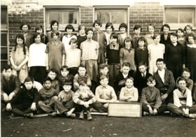
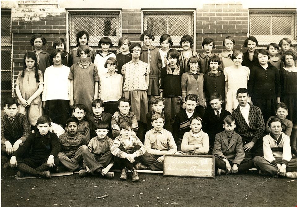
Gilmore Avenue School division VII class
https://search.heritageburnaby.ca/link/museumdescription13692
- Repository
- Burnaby Village Museum
- Date
- April 1927
- Collection/Fonds
- Westerman family fonds
- Description Level
- Item
- Physical Description
- 1 photograph : sepia ; 12.5 x 17.5 cm
- Scope and Content
- Photograph of Gilmore Avenue School Division VII class arranged in rows outside of the school. Walter "Wally" Westerman is identified seated on the ground in the front row, fourth from left.
- Repository
- Burnaby Village Museum
- Collection/Fonds
- Westerman family fonds
- Description Level
- Item
- Physical Description
- 1 photograph : sepia ; 12.5 x 17.5 cm
- Material Details
- `
- Scope and Content
- Photograph of Gilmore Avenue School Division VII class arranged in rows outside of the school. Walter "Wally" Westerman is identified seated on the ground in the front row, fourth from left.
- Subjects
- Persons - Students
- Buildings - Schools
- Geographic Access
- Gilmore Avenue
- Street Address
- 50 Gilmore Avenue
- Accession Code
- BV020.17.16
- Access Restriction
- No restrictions
- Reproduction Restriction
- No known restrictions
- Date
- April 1927
- Media Type
- Photograph
- Historic Neighbourhood
- Vancouver Heights (Historic Neighbourhood)
- Planning Study Area
- Burnaby Heights Area
- Scan Resolution
- 600
- Scan Date
- 22-Sep-2020
- Scale
- 100
- Notes
- Title based on contents of photograph
- Handwritten note in pencil on verso of photograph reads: "Walter aged 10 years / April 1927"
Images
![Sukegoro, Harding and Yasue Yasui with family car, [1927] (date of original), copied 2004 thumbnail](/media/hpo/_Data/_BVM_Images/2019/2019_0032_0037_001.jpg?width=280)
Sukegoro, Harding and Yasue Yasui with family car
https://search.heritageburnaby.ca/link/museumdescription15217
- Repository
- Burnaby Village Museum
- Date
- [1927] (date of original), copied 2004
- Collection/Fonds
- In the Shadow by the Sea collection
- Description Level
- Item
- Physical Description
- 1 photograph (tiff) : 300 dpi
- Scope and Content
- Photograph of Sukegoro Yasui with his daughter, Yasue and son, Harding with their 1918 Dodge sedan. Mr. Yasui is standing next to the car and his children are standing on ther running board. The car is parked on the side of a bridge with a wooden railing.
- Repository
- Burnaby Village Museum
- Collection/Fonds
- In the Shadow by the Sea collection
- Description Level
- Item
- Physical Description
- 1 photograph (tiff) : 300 dpi
- Scope and Content
- Photograph of Sukegoro Yasui with his daughter, Yasue and son, Harding with their 1918 Dodge sedan. Mr. Yasui is standing next to the car and his children are standing on ther running board. The car is parked on the side of a bridge with a wooden railing.
- Geographic Access
- Burrard Inlet
- Accession Code
- BV019.32.37
- Access Restriction
- No restrictions
- Reproduction Restriction
- No known restrictions
- Date
- [1927] (date of original), copied 2004
- Media Type
- Photograph
- Historic Neighbourhood
- Barnet (Historic Neighbourhood)
- Planning Study Area
- Burnaby Mountain Area
- Notes
- Title based on contents of photograph
- See page 129 of book "In the Shadow by the Sea - Recollections of Burnaby's Barnet Village". Caption with photograph reads: "Mr. Sukegoro Yasui with Yasue and Harding by their 1918 Dodge car, 1926"
- Date of photograph [1927] based on birth dates of Yasue "Margaret"- born 1921 and Harding Yasui- born July 1923
- In the Shadow by the Sea spells Sukegoro's wife's name as "Lane" (Harata) Yasui, obits for Sukegoro Yasui and his wife use the spelling "Tane" Hirata Yasui.
Images
![Sukegoro, Harding and Yasue Yasui with family car, [1927] (date of original), copied 2004 thumbnail](/media/hpo/_Data/_BVM_Images/2019/2019_0032_0037_001.jpg)

Fire insurance key plan - Greater Vancouver - Volume XVI - Municipality of Burnaby
https://search.heritageburnaby.ca/link/museumdescription17796
- Repository
- Burnaby Village Museum
- Date
- 1927
- Collection/Fonds
- Burnaby Village Museum Map collection
- Description Level
- Item
- Physical Description
- 2 plans on 2 sheets: col. lithographic print ; 64 x 54 cm
- Scope and Content
- Item consists of a two page fire insurance key plan titled "Greater Vancouver / Volume XVI / Municipality / of Burnaby / Key Plan" surveyed May 1927. Volume XVI includes a two page Key Plan (C and D). .
- Repository
- Burnaby Village Museum
- Collection/Fonds
- Burnaby Village Museum Map collection
- Description Level
- Item
- Physical Description
- 2 plans on 2 sheets: col. lithographic print ; 64 x 54 cm
- Scope and Content
- Item consists of a two page fire insurance key plan titled "Greater Vancouver / Volume XVI / Municipality / of Burnaby / Key Plan" surveyed May 1927. Volume XVI includes a two page Key Plan (C and D). .
- Publisher
- Plan Department of Fire Branch of British Columbia Underwriters Association
- Accession Code
- BV987.1.70
- Access Restriction
- No restrictions
- Reproduction Restriction
- May be restricted by third party rights
- Date
- 1927
- Media Type
- Cartographic Material
- Scan Resolution
- 400
- Scan Date
- 11/17/2021
- Notes
- Title based on contents of item
- Item "GREATER VANCOUVER / VOLUME XVI / MUNICIPALITY OF / BURNABY / KEY PLAN" does not include associated numbered plans (1601 to 1651)
- These plans were removed from a bound book with labels on cover page reading: "Plan No. 90 / THIS INSURANCE PLAN / of / Vancouver VOLUME "8" / IN THE PROPERTY OF THE / British Columbia Insurance Underwriter's Association / Vancouver B.C. / AND IS LOANED / MELVILLE F. THOMSON CO. .../ Date May 26th, 1934"; / "Plan No. 74 / THIS INSURANCE PLAN / OF / VANCOUVER VOLUME "9"" / Plan No. 11 / THIS INSURANCE PLAN / OF / BURNABY VOLUMES 15-19" / "THIS PLAN IS THE PROPERTY OF / THE / BRITISH LAW INSURANCE COMPANY / LIMITED"
Zoomable Images

Fire insurance key plan - Greater Vancouver - Volume XVI - Municipality of Burnaby, 1927
Zoom into Image

Fire insurance key plan - Greater Vancouver - Volume XIX - Municipality of Burnaby
https://search.heritageburnaby.ca/link/museumdescription17799
- Repository
- Burnaby Village Museum
- Date
- 1927
- Collection/Fonds
- Burnaby Village Museum Map collection
- Description Level
- Item
- Physical Description
- 1 plan on 1 sheet : col. lithographic print ; 64 x 54 cm
- Scope and Content
- Item consists of a one page fire insurance key plan titled "Greater Vancouver / Volume XIX / Municipality / of Burnaby / Key Plan" surveyed May 1927. Key plan from compilation, "Insurance Plans of Greater Vancouver Plan No. 11, Volumes 15 to 19 Burnaby".
- Repository
- Burnaby Village Museum
- Collection/Fonds
- Burnaby Village Museum Map collection
- Description Level
- Item
- Physical Description
- 1 plan on 1 sheet : col. lithographic print ; 64 x 54 cm
- Material Details
- Scale [1:6000]
- Scope and Content
- Item consists of a one page fire insurance key plan titled "Greater Vancouver / Volume XIX / Municipality / of Burnaby / Key Plan" surveyed May 1927. Key plan from compilation, "Insurance Plans of Greater Vancouver Plan No. 11, Volumes 15 to 19 Burnaby".
- Publisher
- Plan Department of Fire Branch of British Columbia Underwriters' Association
- Accession Code
- BV987.1.70
- Access Restriction
- No restrictions
- Reproduction Restriction
- May be restricted by third party rights
- Date
- 1927
- Media Type
- Cartographic Material
- Historic Neighbourhood
- Fraser Arm (Historic Neighbourhood)
- Planning Study Area
- Big Bend Area
- Scan Resolution
- 400
- Scan Date
- 2021-11-17
- Notes
- Title based on contents of item
- Scale 500 feet = 1 inch
- These plans were removed from a bound book with labels on cover page reading: "Plan No. 90 / THIS INSURANCE PLAN / of / Vancouver VOLUME "8" / IN THE PROPERTY OF THE / British Columbia Insurance Underwriter's Association / Vancouver B.C. / AND IS LOANED / MELVILLE F. THOMSON CO. .../ Date May 26th, 1934"; / "Plan No. 74 / THIS INSURANCE PLAN / OF / VANCOUVER VOLUME "9"" / Plan No. 11 / THIS INSURANCE PLAN / OF / BURNABY VOLUMES 15-19" / "THIS PLAN IS THE PROPERTY OF / THE / BRITISH LAW INSURANCE COMPANY / LIMITED"
- Does not include the corresponding key plan page or associated plans numbered 1901 to 1914
- Contact Burnaby Village Museum to view associated fire insurance plans
Zoomable Images

Fire insurance key plan - Greater Vancouver - Volume XIX - Municipality of Burnaby, 1927
Zoom into Image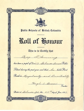
Roll of honour certificate
https://search.heritageburnaby.ca/link/museumdescription18984
- Repository
- Burnaby Village Museum
- Date
- 24 Jun. 1927
- Collection/Fonds
- Waplington family fonds
- Description Level
- Item
- Physical Description
- 1 p.
- Scope and Content
- Item consists of a Public Schools of British Columbia Roll of Honour certificate awarded to Ray Fleming on 24th day of June 1927.
- Repository
- Burnaby Village Museum
- Collection/Fonds
- Waplington family fonds
- Description Level
- Item
- Physical Description
- 1 p.
- Scope and Content
- Item consists of a Public Schools of British Columbia Roll of Honour certificate awarded to Ray Fleming on 24th day of June 1927.
- Accession Code
- BV016.46.144
- Access Restriction
- No restrictions
- Reproduction Restriction
- No known restrictions
- Date
- 24 Jun. 1927
- Media Type
- Textual Record
- Scan Resolution
- 600
- Scan Date
- 2023-01-06
- Notes
- Title based on contents of item
- Document is part of Photograph album BV016.46.52
Images

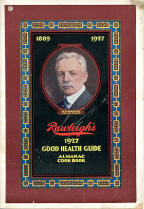
Rawleigh's good health guide cookbook almanac
https://search.heritageburnaby.ca/link/museumlibrary5547
- Repository
- Burnaby Village Museum
- Author
- W.T. Rawleigh Company
- Publication Date
- 1927
- Call Number
- 613 RAW
- Repository
- Burnaby Village Museum
- Collection
- Special Collection
- Material Type
- Book
- Accession Code
- HV973.76.6
- Call Number
- 613 RAW
- Author
- W.T. Rawleigh Company
- Place of Publication
- Montreal ; Winnipeg
- Publisher
- W. T. Rawleigh Company
- Publication Date
- 1927
- Physical Description
- 64 p. ill., (some col.)
- Library Subject (LOC)
- Cooking, American
- Health--Popular works
- Home economics
- Nutrition--Popular works
- Cookbooks--1920-1929
- Notes
- "1889" "1927" on front cover.
Images


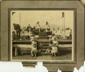
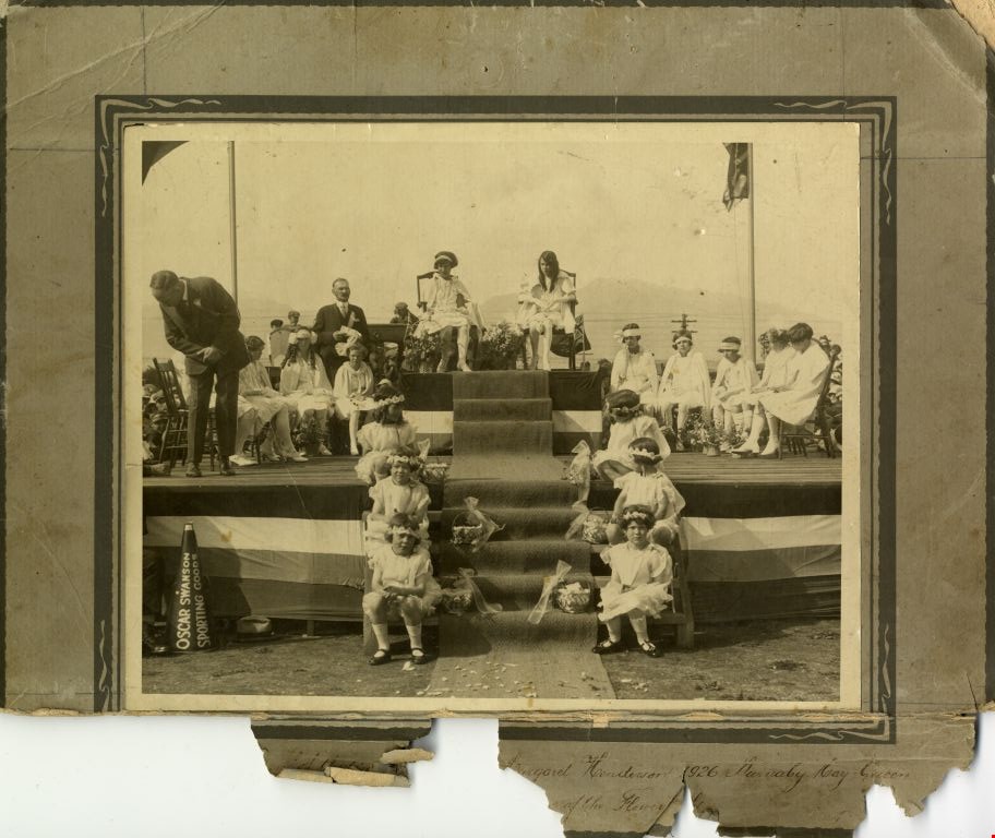
May Day
https://search.heritageburnaby.ca/link/museumdescription38
- Repository
- Burnaby Village Museum
- Date
- May 1926
- Collection/Fonds
- Burnaby Village Museum Photograph collection
- Description Level
- Item
- Physical Description
- 1 photograph : b&w ; 20 x 24 cm, mounted on card 29.5 x 35 cm
- Scope and Content
- Photograph of Burnaby May Queen Margaret Henderson sitting on a platform on a stage with the out-going May Queen, Ruth Bearn. Two Burnaby officials are standing on the stage. The Queen's suite is sitting on the stage (Flora McCallum is sitting third from the left and has long culry hair) with the y…
- Repository
- Burnaby Village Museum
- Collection/Fonds
- Burnaby Village Museum Photograph collection
- Description Level
- Item
- Physical Description
- 1 photograph : b&w ; 20 x 24 cm, mounted on card 29.5 x 35 cm
- Material Details
- A ribbon (used for hanging) is attached to verso of card mount
- Scope and Content
- Photograph of Burnaby May Queen Margaret Henderson sitting on a platform on a stage with the out-going May Queen, Ruth Bearn. Two Burnaby officials are standing on the stage. The Queen's suite is sitting on the stage (Flora McCallum is sitting third from the left and has long culry hair) with the younger ones sitting on either side of the steps.
- Subjects
- Events - May Day
- Accession Code
- HV971.144.5
- Access Restriction
- No restrictions
- Date
- May 1926
- Media Type
- Photograph
- Scan Resolution
- 600
- Scan Date
- 1/11/2010
- Scale
- 100
- Notes
- Title based on contents of photograph
Images

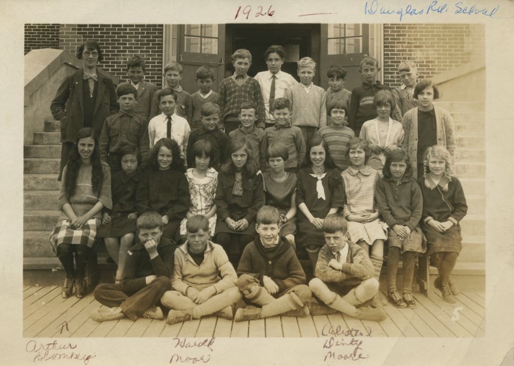
Students at Douglas Road School
https://search.heritageburnaby.ca/link/museumdescription79
- Repository
- Burnaby Village Museum
- Date
- 1926
- Collection/Fonds
- Burnaby Village Museum Photograph collection
- Description Level
- Item
- Physical Description
- 1 photograph : b&w ; 10.5 x 15.5 cm
- Scope and Content
- Photograph of students sitting and standing on the steps of Douglas Road School with their teacher (wearing glasses and an overcoat) on the far left at the back. In the front row, Arthur Blomberg is sitting on the far left, next to him is Harold Moore, with William A. "Dinty" Moore on the far right…
- Repository
- Burnaby Village Museum
- Collection/Fonds
- Burnaby Village Museum Photograph collection
- Description Level
- Item
- Physical Description
- 1 photograph : b&w ; 10.5 x 15.5 cm
- Scope and Content
- Photograph of students sitting and standing on the steps of Douglas Road School with their teacher (wearing glasses and an overcoat) on the far left at the back. In the front row, Arthur Blomberg is sitting on the far left, next to him is Harold Moore, with William A. "Dinty" Moore on the far right. The other students are not identified.
- Subjects
- Occupations - Teachers
- Geographic Access
- Canada Way
- Street Address
- 4861 Canada Way
- Accession Code
- BV989.28.2
- Access Restriction
- No restrictions
- Date
- 1926
- Media Type
- Photograph
- Historic Neighbourhood
- Burnaby Lake (Historic Neighbourhood)
- Planning Study Area
- Douglas-Gilpin Area
- Scan Resolution
- 600
- Scan Date
- 01-Jun-09
- Scale
- 100
- Notes
- Title based on contents of photograph
- Photographer identifies photograph as no. 5
- Notes on recto of photograph read: "Douglas Rd. School" and "1926 / Arthur Blomberg / Harold Moore / (Alister) Dinty Moore"
Images