Narrow Results By
Subject
- Advertising Medium - Signs and Signboards 1
- Aerial Photographs 3
- Animals - Horses 1
- Buildings - Civic 1
- Buildings - Commercial 1
- Buildings - Commercial - Banks 1
- Buildings - Commercial - Grocery Stores 1
- Buildings - Commercial - Hardware Stores 1
- Buildings - Commercial - Restaurants 1
- Buildings - Commercial - Stores 5
- Buildings - Industrial 1
- Buildings - Industrial - Refineries 3

Helen 'The Swinging Girl' Neon Sign
https://search.heritageburnaby.ca/link/landmark591
- Repository
- Burnaby Heritage Planning
- Description
- Commercial building.
- Associated Dates
- 1956
- Formal Recognition
- Heritage Designation, Community Heritage Register
- Other Names
- Helen's Childrens Wear Sign
- Street View URL
- Google Maps Street View
- Repository
- Burnaby Heritage Planning
- Other Names
- Helen's Childrens Wear Sign
- Geographic Access
- Hastings Street
- Associated Dates
- 1956
- Formal Recognition
- Heritage Designation, Community Heritage Register
- Enactment Type
- Bylaw No. 12771
- Enactment Date
- 19/04/2010
- Description
- Commercial building.
- Heritage Value
- While the building here is of some importance as the former North Burnaby municipal office, its primary importance is its delightful neon sign that has become a North Burnaby landmark. Helen Arnold opened Helen’s Childrens Wear shop in the building next door to the old Municipal offices in 1948. In 1955, when North Burnaby moved out, she moved into the vacated building. As part of the renovations, Helen enlisted the assistance of her good friend Jimmy Wallace, owner of Vancouver’s Wallace Neon Company, to create a new sign for her expanded business. One of the company’s designers, Reeve Lehman, created the swinging neon girl that was installed in 1956. Designed in two parts, one section of the sign is cloud shaped and reads ‘Helen’s’ while the other section is a moving representation of a little girl on a swing. The sign is nine feet six inches high and nine feet wide, and the lower section is animated with an internal motor and gears. It immediately became a landmark on Hastings Street, and recently the sign’s design fame has spread far and wide as one of the best surviving examples of kinetic neon art in North America.
- Locality
- Vancouver Heights
- Historic Neighbourhood
- Vancouver Heights (Historic Neighbourhood)
- Planning Study Area
- Willingdon Heights Area
- Community
- Burnaby
- Names
- Helen's Childrens Wear
- Street Address
- 4142 Hastings Street
- Street View URL
- Google Maps Street View
Images


Willingdon Heights United Church
https://search.heritageburnaby.ca/link/landmark658
- Repository
- Burnaby Heritage Planning
- Description
- Church building.
- Associated Dates
- 1951
- Street View URL
- Google Maps Street View
- Repository
- Burnaby Heritage Planning
- Geographic Access
- Parker Street
- Associated Dates
- 1951
- Description
- Church building.
- Heritage Value
- This church was built to serve a 500-home subdivision known as Willingdon Heights–Canada’s largest single veteran’s housing project created by the Central Mortgage and Housing Corporation and constructed by the Whitsell Construction Company in 1948. The church building was designed as a simplified Gothic Revival church with a tall front tower and Gothic pointed-arch stained glass window and entrance. This church was designed by Vancouver architects Twizell & Twizell. Both Robert Twizell (1875-1964) and younger brother George Twizell (1885-1957) articled at Newcastle, England’s Hicks & Charlewood before arriving in Vancouver in late 1907 or early 1908, with George working for Robert until they established a partnership a few years later. Their firm lasted for nearly half a century and was well known for its numerous church designs.
- Locality
- Vancouver Heights
- Historic Neighbourhood
- Vancouver Heights (Historic Neighbourhood)
- Planning Study Area
- Willingdon Heights Area
- Architect
- Twizell & Twizell
- Area
- 1808.82
- Contributing Resource
- Building
- Ownership
- Private
- Street Address
- 4304 Parker Street
- Street View URL
- Google Maps Street View
Images


Vancouver Heights Neighbourhood
https://search.heritageburnaby.ca/link/landmark666
- Repository
- Burnaby Heritage Planning
- Associated Dates
- 1925-1954
- Heritage Value
- Vancouver Heights remained an important residential and commercial centre in Burnaby throughout the 1925-1954 period. The area had its own Board of Trade and the North Burnaby Library was created to serve the residents. In 1949, the Hastings streetcars stopped running, but the area retained its reputation as one of the best shopping districts in the city.
- Historic Neighbourhood
- Vancouver Heights (Historic Neighbourhood)
- Planning Study Area
- Burnaby Heights Area
Images


Crabtown
https://search.heritageburnaby.ca/link/landmark674
- Repository
- Burnaby Heritage Planning
- Associated Dates
- 1912-1957
- Heritage Value
- North Burnaby's waterfront was the location of a unique squatter's community known as Crabtown. Although its origins are obscure, it is believed that the first shacks were built before 1912. When the depression of 1913-1917 began, the shacks became permanent homes for impoverished workers. During the Great Depression of the 1930s, the community grew larger. Crabtown was not a slum, but a neighbourhood - the community even rallied together to build a water supply system and trails up the steep bluff with steps and banisters so children could go to school safely. In 1957, the National Harbours Board decided that Crabtown was encroaching on Federal property and evicted all 130 residents. Within a few months, residents were relocated and 114 homes were levelled.
- Historic Neighbourhood
- Vancouver Heights (Historic Neighbourhood)
- Planning Study Area
- Burnaby Heights Area
Images


Burnaby Heights Neighbourhood
https://search.heritageburnaby.ca/link/landmark776
- Repository
- Burnaby Heritage Planning
- Associated Dates
- 1955-2008
- Heritage Value
- Up until the 1970s, this neighbourhood was known as Vancouver Heights. When a new park was created during that decade and named "Burnaby Heights Park," the name was gradually adopted by newcomers to the area. Today, you will hear residents refer to their neighbourhood as Burnaby Heights, Vancouver Heights, or just "The Heights." Throughout the 1960s and 1970s, the commercial district in this neighbourhood continued to grow and a Retail Merchants Association was formed which later became known as the Heights Merchants Association. The neighbourhood still retains a residential neighbourhood characteristic with an increasing number of apartment buildings and multi-family units being built over the past 20 years.
- Historic Neighbourhood
- Vancouver Heights (Historic Neighbourhood)
- Planning Study Area
- Burnaby Heights Area
Images

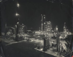
Standard Oil Stanovan Refinery
https://search.heritageburnaby.ca/link/archivedescription34566
- Repository
- City of Burnaby Archives
- Date
- 1958
- Collection/Fonds
- Burnaby Historical Society fonds
- Description Level
- Item
- Physical Description
- 1 photograph : b&w ; 27.8 x 35.3 cm
- Scope and Content
- Photograph of the Standard Oil Company Stanovan Refinery process area, Burrard Inlet. The area is lit up at night. Photograph of the Standard Oil Refinery at night. After the government broke up Standard Oil in 1911, its West Coast operations became the Standard Oil of California (SoCal), owning t…
- Repository
- City of Burnaby Archives
- Date
- 1958
- Collection/Fonds
- Burnaby Historical Society fonds
- Subseries
- Photographs subseries
- Physical Description
- 1 photograph : b&w ; 27.8 x 35.3 cm
- Description Level
- Item
- Record No.
- 052-002
- Access Restriction
- No restrictions
- Reproduction Restriction
- Reproduce for fair dealing purposes only
- Accession Number
- BHS2007-04
- Scope and Content
- Photograph of the Standard Oil Company Stanovan Refinery process area, Burrard Inlet. The area is lit up at night. Photograph of the Standard Oil Refinery at night. After the government broke up Standard Oil in 1911, its West Coast operations became the Standard Oil of California (SoCal), owning the Standard Oil Company of British Columbia Ltd, and adopting the name Chevron in the 1970's.
- Subjects
- Buildings - Industrial - Refineries
- Media Type
- Photograph
- Photographer
- Industrial Photographers
- Notes
- Title based on contents of photograph
- Geographic Access
- Eton Street
- Street Address
- 4403 Eton Street
- Historic Neighbourhood
- Vancouver Heights (Historic Neighbourhood)
- Planning Study Area
- Burnaby Heights Area
Images
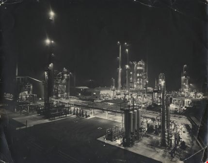

Standard Oil Company
https://search.heritageburnaby.ca/link/archivedescription34567
- Repository
- City of Burnaby Archives
- Date
- 1958
- Collection/Fonds
- Burnaby Historical Society fonds
- Description Level
- Item
- Physical Description
- 1 photograph : b&w ; 28.0 x 35.8 cm
- Scope and Content
- Aerial photograph of the Standard Oil Company Stanovan Refinery storage and shipping area, along the Burrard Inlet.
- Repository
- City of Burnaby Archives
- Date
- 1958
- Collection/Fonds
- Burnaby Historical Society fonds
- Subseries
- Photographs subseries
- Physical Description
- 1 photograph : b&w ; 28.0 x 35.8 cm
- Description Level
- Item
- Record No.
- 052-003
- Access Restriction
- No restrictions
- Reproduction Restriction
- Reproduce for fair dealing purposes only
- Accession Number
- BHS2007-04
- Scope and Content
- Aerial photograph of the Standard Oil Company Stanovan Refinery storage and shipping area, along the Burrard Inlet.
- Media Type
- Photograph
- Notes
- Title based on contents of photograph
- Geographic Access
- Eton Street
- Street Address
- 4403 Eton Street
- Historic Neighbourhood
- Vancouver Heights (Historic Neighbourhood)
- Planning Study Area
- Burnaby Heights Area
Images


Standard Oil Company
https://search.heritageburnaby.ca/link/archivedescription34568
- Repository
- City of Burnaby Archives
- Date
- 1958
- Collection/Fonds
- Burnaby Historical Society fonds
- Description Level
- Item
- Physical Description
- 1 photograph : b&w ; 27.8 x 35.5 cm
- Scope and Content
- Aerial photograph of the Standard Oil Company Stanovan Refinery, Burrard Inlet.
- Repository
- City of Burnaby Archives
- Date
- 1958
- Collection/Fonds
- Burnaby Historical Society fonds
- Subseries
- Photographs subseries
- Physical Description
- 1 photograph : b&w ; 27.8 x 35.5 cm
- Description Level
- Item
- Record No.
- 052-004
- Access Restriction
- No restrictions
- Reproduction Restriction
- Reproduce for fair dealing purposes only
- Accession Number
- BHS2007-04
- Scope and Content
- Aerial photograph of the Standard Oil Company Stanovan Refinery, Burrard Inlet.
- Media Type
- Photograph
- Photographer
- Aero Surveys Limited
- Notes
- Title based on contents of photograph
- Back of photo stamped: "Photo by Aero Surveys Limited, Vancouver, BC, Canada / Identification No.: BO-58-444"
- Geographic Access
- Eton Street
- Street Address
- 4403 Eton Street
- Historic Neighbourhood
- Vancouver Heights (Historic Neighbourhood)
- Planning Study Area
- Burnaby Heights Area
Images

![Bank of Montreal, [195-] thumbnail](/media/hpo/_Data/_Archives_Images/_Unrestricted/001/073-001.jpg?width=280)
Bank of Montreal
https://search.heritageburnaby.ca/link/archivedescription34638
- Repository
- City of Burnaby Archives
- Date
- [195-]
- Collection/Fonds
- Burnaby Historical Society fonds
- Description Level
- Item
- Physical Description
- 1 photograph : b&w ; 24.7 x 17.4 cm
- Scope and Content
- Photograph of the exterior of the Bank of Montreal at 418 Willingdon Avenue and Hastings Street.
- Repository
- City of Burnaby Archives
- Date
- [195-]
- Collection/Fonds
- Burnaby Historical Society fonds
- Subseries
- Photographs subseries
- Physical Description
- 1 photograph : b&w ; 24.7 x 17.4 cm
- Description Level
- Item
- Record No.
- 073-001
- Access Restriction
- No restrictions
- Reproduction Restriction
- Reproduce for fair dealing purposes only
- Accession Number
- BHS2007-04
- Scope and Content
- Photograph of the exterior of the Bank of Montreal at 418 Willingdon Avenue and Hastings Street.
- Subjects
- Buildings - Commercial - Banks
- Names
- Bank of Montreal
- Media Type
- Photograph
- Notes
- Title based on contents of photograph
- Geographic Access
- Willingdon Avenue
- Street Address
- 418 Willingdon Avenue
- Historic Neighbourhood
- Vancouver Heights (Historic Neighbourhood)
- Planning Study Area
- Brentwood Area
Images
![Bank of Montreal, [195-] thumbnail](/media/hpo/_Data/_Archives_Images/_Unrestricted/001/073-001.jpg)
![North Burnaby, [1959] thumbnail](/media/hpo/_Data/_Archives_Images/_Unrestricted/001/106-001.jpg?width=280)
North Burnaby
https://search.heritageburnaby.ca/link/archivedescription34701
- Repository
- City of Burnaby Archives
- Date
- [1959]
- Collection/Fonds
- Burnaby Historical Society fonds
- Description Level
- Item
- Physical Description
- 1 photograph : b&w ; 16.6 x 20.5 cm
- Scope and Content
- Aerial photograph of North Burnaby and Burrard Inlet looking west.
- Repository
- City of Burnaby Archives
- Date
- [1959]
- Collection/Fonds
- Burnaby Historical Society fonds
- Subseries
- Photographs subseries
- Physical Description
- 1 photograph : b&w ; 16.6 x 20.5 cm
- Description Level
- Item
- Record No.
- 106-001
- Access Restriction
- No restrictions
- Reproduction Restriction
- Reproduce for fair dealing purposes only
- Accession Number
- BHS2007-04
- Scope and Content
- Aerial photograph of North Burnaby and Burrard Inlet looking west.
- Media Type
- Photograph
- Notes
- Title based on contents of photograph
- Historic Neighbourhood
- Vancouver Heights (Historic Neighbourhood)
- Capitol Hill (Historic Neighbourhood)
- Lochdale (Historic Neighbourhood)
- Planning Study Area
- Burnaby Heights Area
- Capitol Hill Area
- Westridge Area
- Willingdon Heights Area
- Brentwood Area
- Parkcrest-Aubrey Area
- Lochdale Area
Images
![North Burnaby, [1959] thumbnail](/media/hpo/_Data/_Archives_Images/_Unrestricted/001/106-001.jpg)
![St. Helen's Church, [1955-1956] thumbnail](/media/hpo/_Data/_Archives_Images/_Unrestricted/494/495-001.jpg?width=280)
St. Helen's Church
https://search.heritageburnaby.ca/link/archivedescription58377
- Repository
- City of Burnaby Archives
- Date
- [1955-1956]
- Collection/Fonds
- Sheila Minni fonds
- Description Level
- Item
- Physical Description
- 1 photograph : sepia ; 4.5 x 7 cm
- Scope and Content
- Photograph of a fire at the manse next to St. Helen's Church. Two children with bicycles can be seen standing near the street corner.
- Repository
- City of Burnaby Archives
- Date
- [1955-1956]
- Collection/Fonds
- Sheila Minni fonds
- Physical Description
- 1 photograph : sepia ; 4.5 x 7 cm
- Description Level
- Item
- Record No.
- 495-001
- Access Restriction
- No restrictions
- Reproduction Restriction
- No known restrictions
- Accession Number
- 2009-04
- Scope and Content
- Photograph of a fire at the manse next to St. Helen's Church. Two children with bicycles can be seen standing near the street corner.
- Subjects
- Buildings - Religious - Churches
- Media Type
- Photograph
- Notes
- Title based on contents of photograph
- Geographic Access
- Triumph Street
- Street Address
- 3894 Triumph Street
- Historic Neighbourhood
- Vancouver Heights (Historic Neighbourhood)
- Planning Study Area
- Burnaby Heights Area
Images
![St. Helen's Church, [1955-1956] thumbnail](/media/hpo/_Data/_Archives_Images/_Unrestricted/494/495-001.jpg)
![St. Helen's Church Steeple, [1955-1956] thumbnail](/media/hpo/_Data/_Archives_Images/_Unrestricted/494/495-002.jpg?width=280)
St. Helen's Church Steeple
https://search.heritageburnaby.ca/link/archivedescription58378
- Repository
- City of Burnaby Archives
- Date
- [1955-1956]
- Collection/Fonds
- Sheila Minni fonds
- Description Level
- Item
- Physical Description
- 1 photograph : sepia ; 4.5 x 7 cm
- Scope and Content
- Photograph of the steeple of St. Helen's Church after it was torn down. The Church was replaced in 1956 when a new building was constructed. Siting inside the steeple are three children: the girl on the right has been identified as Sheila Minni, the boy seated up in the middle of the steeple is B…
- Repository
- City of Burnaby Archives
- Date
- [1955-1956]
- Collection/Fonds
- Sheila Minni fonds
- Physical Description
- 1 photograph : sepia ; 4.5 x 7 cm
- Description Level
- Item
- Record No.
- 495-002
- Access Restriction
- No restrictions
- Reproduction Restriction
- No known restrictions
- Accession Number
- 2009-04
- Scope and Content
- Photograph of the steeple of St. Helen's Church after it was torn down. The Church was replaced in 1956 when a new building was constructed. Siting inside the steeple are three children: the girl on the right has been identified as Sheila Minni, the boy seated up in the middle of the steeple is Bobby Priest and the other girl is known only as Katherine.
- Subjects
- Buildings - Religious - Churches
- Media Type
- Photograph
- Notes
- Title based on contents of photograph
- Geographic Access
- Triumph Street
- Street Address
- 3894 Triumph Street
- Historic Neighbourhood
- Vancouver Heights (Historic Neighbourhood)
- Planning Study Area
- Burnaby Heights Area
Images
![St. Helen's Church Steeple, [1955-1956] thumbnail](/media/hpo/_Data/_Archives_Images/_Unrestricted/494/495-002.jpg)
![Moving St. Helen's Church, [1955-1956] thumbnail](/media/hpo/_Data/_Archives_Images/_Unrestricted/494/495-003.jpg?width=280)
Moving St. Helen's Church
https://search.heritageburnaby.ca/link/archivedescription58379
- Repository
- City of Burnaby Archives
- Date
- [1955-1956]
- Collection/Fonds
- Sheila Minni fonds
- Description Level
- Item
- Physical Description
- 1 photograph : sepia ; 4.5 x 7 cm
- Scope and Content
- Photograph of a truck moving the St. Helen's Church building. The Church was replaced in 1956 with a new building.
- Repository
- City of Burnaby Archives
- Date
- [1955-1956]
- Collection/Fonds
- Sheila Minni fonds
- Physical Description
- 1 photograph : sepia ; 4.5 x 7 cm
- Description Level
- Item
- Record No.
- 495-003
- Access Restriction
- No restrictions
- Reproduction Restriction
- No known restrictions
- Accession Number
- 2009-04
- Scope and Content
- Photograph of a truck moving the St. Helen's Church building. The Church was replaced in 1956 with a new building.
- Media Type
- Photograph
- Notes
- Title based on contents of photograph
- Geographic Access
- Triumph Street
- Street Address
- 3894 Triumph Street
- Historic Neighbourhood
- Vancouver Heights (Historic Neighbourhood)
- Planning Study Area
- Burnaby Heights Area
Images
![Moving St. Helen's Church, [1955-1956] thumbnail](/media/hpo/_Data/_Archives_Images/_Unrestricted/494/495-003.jpg)
![Outside Safeway, [195-] (date of original), copied 1992 thumbnail](/media/hpo/_Data/_Archives_Images/_Unrestricted/315/315-044.jpg?width=280)
Outside Safeway
https://search.heritageburnaby.ca/link/archivedescription36689
- Repository
- City of Burnaby Archives
- Date
- [195-] (date of original), copied 1992
- Collection/Fonds
- Burnaby Historical Society fonds
- Description Level
- Item
- Physical Description
- 1 photograph : b&w ; 8.2 x 12.2 cm print
- Scope and Content
- Photograph of two women standing beside a car in the parking lot of Safeway. The woman on the left may be Betty Stevenson.
- Repository
- City of Burnaby Archives
- Date
- [195-] (date of original), copied 1992
- Collection/Fonds
- Burnaby Historical Society fonds
- Subseries
- Burnaby Centennial Anthology subseries
- Physical Description
- 1 photograph : b&w ; 8.2 x 12.2 cm print
- Description Level
- Item
- Record No.
- 315-044
- Access Restriction
- No restrictions
- Reproduction Restriction
- Reproduce for fair dealing purposes only
- Accession Number
- BHS1994-04
- Scope and Content
- Photograph of two women standing beside a car in the parking lot of Safeway. The woman on the left may be Betty Stevenson.
- Names
- Safeway
- Stevenson, Betty
- Media Type
- Photograph
- Notes
- Title based on contents of photograph
- Geographic Access
- Hastings Street
- Street Address
- 4440 Hastings Street
- Historic Neighbourhood
- Vancouver Heights (Historic Neighbourhood)
- Planning Study Area
- Willingdon Heights Area
Images
![Outside Safeway, [195-] (date of original), copied 1992 thumbnail](/media/hpo/_Data/_Archives_Images/_Unrestricted/315/315-044.jpg)
![Allan Beaton, [195-] (date of original), copied 1992 thumbnail](/media/hpo/_Data/_Archives_Images/_Unrestricted/315/315-045.jpg?width=280)
Allan Beaton
https://search.heritageburnaby.ca/link/archivedescription36690
- Repository
- City of Burnaby Archives
- Date
- [195-] (date of original), copied 1992
- Collection/Fonds
- Burnaby Historical Society fonds
- Description Level
- Item
- Physical Description
- 1 photograph : b&w ; 11 x 9 cm print
- Scope and Content
- Photograph of Allan Beaton inspecting an apple tree in front of a house.
- Repository
- City of Burnaby Archives
- Date
- [195-] (date of original), copied 1992
- Collection/Fonds
- Burnaby Historical Society fonds
- Subseries
- Burnaby Centennial Anthology subseries
- Physical Description
- 1 photograph : b&w ; 11 x 9 cm print
- Description Level
- Item
- Record No.
- 315-045
- Access Restriction
- No restrictions
- Reproduction Restriction
- Reproduce for fair dealing purposes only
- Accession Number
- BHS1994-04
- Scope and Content
- Photograph of Allan Beaton inspecting an apple tree in front of a house.
- Names
- Beaton, Allan
- Media Type
- Photograph
- Notes
- Title based on contents of photograph
- Geographic Access
- Parker Street
- Street Address
- 3966 Parker Street
- Historic Neighbourhood
- Vancouver Heights (Historic Neighbourhood)
- Planning Study Area
- Willingdon Heights Area
Images
![Allan Beaton, [195-] (date of original), copied 1992 thumbnail](/media/hpo/_Data/_Archives_Images/_Unrestricted/315/315-045.jpg)
![Stevenson family, [195-] (date of original), copied 1992 thumbnail](/media/hpo/_Data/_Archives_Images/_Unrestricted/315/315-047.jpg?width=280)
Stevenson family
https://search.heritageburnaby.ca/link/archivedescription36692
- Repository
- City of Burnaby Archives
- Date
- [195-] (date of original), copied 1992
- Collection/Fonds
- Burnaby Historical Society fonds
- Description Level
- Item
- Physical Description
- 1 photograph : b&w ; 11 x 9 cm print
- Scope and Content
- Photograph of two women in the Stevenson family standing in the backyard of their residence. The woman on the right may be Betty Stevenson.
- Repository
- City of Burnaby Archives
- Date
- [195-] (date of original), copied 1992
- Collection/Fonds
- Burnaby Historical Society fonds
- Subseries
- Burnaby Centennial Anthology subseries
- Physical Description
- 1 photograph : b&w ; 11 x 9 cm print
- Description Level
- Item
- Record No.
- 315-047
- Access Restriction
- No restrictions
- Reproduction Restriction
- Reproduce for fair dealing purposes only
- Accession Number
- BHS1994-04
- Scope and Content
- Photograph of two women in the Stevenson family standing in the backyard of their residence. The woman on the right may be Betty Stevenson.
- Subjects
- Buildings - Residential - Houses
- Names
- Stevenson, Betty
- Media Type
- Photograph
- Notes
- Title based on contents of photograph
- Geographic Access
- Parker Street
- Street Address
- 3966 Parker Street
- Historic Neighbourhood
- Vancouver Heights (Historic Neighbourhood)
- Planning Study Area
- Willingdon Heights Area
Images
![Stevenson family, [195-] (date of original), copied 1992 thumbnail](/media/hpo/_Data/_Archives_Images/_Unrestricted/315/315-047.jpg)
![Betty Stevenson in the Stevenson family garden, [195-] (date of original), copied 1992 thumbnail](/media/hpo/_Data/_Archives_Images/_Unrestricted/315/315-048.jpg?width=280)
Betty Stevenson in the Stevenson family garden
https://search.heritageburnaby.ca/link/archivedescription36693
- Repository
- City of Burnaby Archives
- Date
- [195-] (date of original), copied 1992
- Collection/Fonds
- Burnaby Historical Society fonds
- Description Level
- Item
- Physical Description
- 1 photograph : b&w ; 8.7 x 10.9 cm print
- Scope and Content
- Photograph of Betty Stevenson in the Stevenson family garden.
- Repository
- City of Burnaby Archives
- Date
- [195-] (date of original), copied 1992
- Collection/Fonds
- Burnaby Historical Society fonds
- Subseries
- Burnaby Centennial Anthology subseries
- Physical Description
- 1 photograph : b&w ; 8.7 x 10.9 cm print
- Description Level
- Item
- Record No.
- 315-048
- Access Restriction
- No restrictions
- Reproduction Restriction
- Reproduce for fair dealing purposes only
- Accession Number
- BHS1994-04
- Scope and Content
- Photograph of Betty Stevenson in the Stevenson family garden.
- Subjects
- Geographic Features - Gardens
- Names
- Stevenson, Betty
- Media Type
- Photograph
- Notes
- Title based on contents of photograph
- Geographic Access
- Parker Street
- Street Address
- 3966 Parker Street
- Historic Neighbourhood
- Vancouver Heights (Historic Neighbourhood)
- Planning Study Area
- Willingdon Heights Area
Images
![Betty Stevenson in the Stevenson family garden, [195-] (date of original), copied 1992 thumbnail](/media/hpo/_Data/_Archives_Images/_Unrestricted/315/315-048.jpg)
![George Winter, [1950] (date of original), copied 1992 thumbnail](/media/hpo/_Data/_Archives_Images/_Unrestricted/315/315-133.jpg?width=280)
George Winter
https://search.heritageburnaby.ca/link/archivedescription36776
- Repository
- City of Burnaby Archives
- Date
- [1950] (date of original), copied 1992
- Collection/Fonds
- Burnaby Historical Society fonds
- Description Level
- Item
- Physical Description
- 1 photograph : b&w ; 11 x 7.5 cm print
- Scope and Content
- Photograph of George Winter who worked as a commissionaire (guard) for the Loomis Armoured Car company.
- Repository
- City of Burnaby Archives
- Date
- [1950] (date of original), copied 1992
- Collection/Fonds
- Burnaby Historical Society fonds
- Subseries
- Burnaby Centennial Anthology subseries
- Physical Description
- 1 photograph : b&w ; 11 x 7.5 cm print
- Description Level
- Item
- Record No.
- 315-133
- Access Restriction
- No restrictions
- Reproduction Restriction
- Reproduce for fair dealing purposes only
- Accession Number
- BHS1994-04
- Scope and Content
- Photograph of George Winter who worked as a commissionaire (guard) for the Loomis Armoured Car company.
- Subjects
- Clothing - Uniforms
- Media Type
- Photograph
- Notes
- Title based on contents of photograph
- Geographic Access
- Frances Street
- Street Address
- 3793 Frances Street
- Historic Neighbourhood
- Vancouver Heights (Historic Neighbourhood)
- Planning Study Area
- Willingdon Heights Area
Images
![George Winter, [1950] (date of original), copied 1992 thumbnail](/media/hpo/_Data/_Archives_Images/_Unrestricted/315/315-133.jpg)
![Two women, [195-?] (date of original), copied 1992 thumbnail](/media/hpo/_Data/_Archives_Images/_Unrestricted/315/315-253.jpg?width=280)
Two women
https://search.heritageburnaby.ca/link/archivedescription36796
- Repository
- City of Burnaby Archives
- Date
- [195-?] (date of original), copied 1992
- Collection/Fonds
- Burnaby Historical Society fonds
- Description Level
- Item
- Physical Description
- 1 photograph : b&w ; 7.7 x 10.9 cm print
- Scope and Content
- Photograph of young women standing on Gilmore Avenue. In the background is a store called Oxmore Market. The women may be Patricia Allen and Marjorie Allen.
- Repository
- City of Burnaby Archives
- Date
- [195-?] (date of original), copied 1992
- Collection/Fonds
- Burnaby Historical Society fonds
- Subseries
- Burnaby Centennial Anthology subseries
- Physical Description
- 1 photograph : b&w ; 7.7 x 10.9 cm print
- Description Level
- Item
- Record No.
- 315-253
- Access Restriction
- No restrictions
- Reproduction Restriction
- Reproduce for fair dealing purposes only
- Accession Number
- BHS1994-04
- Scope and Content
- Photograph of young women standing on Gilmore Avenue. In the background is a store called Oxmore Market. The women may be Patricia Allen and Marjorie Allen.
- Subjects
- Buildings - Commercial - Stores
- Names
- Oxmore Market
- Media Type
- Photograph
- Notes
- Title based on contents of photograph
- Geographic Access
- Gilmore Avenue
- Street Address
- 104 Gilmore Avenue
- Historic Neighbourhood
- Vancouver Heights (Historic Neighbourhood)
- Planning Study Area
- Burnaby Heights Area
Images
![Two women, [195-?] (date of original), copied 1992 thumbnail](/media/hpo/_Data/_Archives_Images/_Unrestricted/315/315-253.jpg)

Davies Family Home
https://search.heritageburnaby.ca/link/archivedescription37055
- Repository
- City of Burnaby Archives
- Date
- 1950 (date of original), copied 1992
- Collection/Fonds
- Burnaby Historical Society fonds
- Description Level
- Item
- Physical Description
- 1 photograph : b&w ; 8.5 x 12.3 cm print
- Scope and Content
- Photograph of the Davies' home at 224 Boundary Road. A 1950 Studebaker car is parked in front.
- Repository
- City of Burnaby Archives
- Date
- 1950 (date of original), copied 1992
- Collection/Fonds
- Burnaby Historical Society fonds
- Subseries
- Burnaby Centennial Anthology subseries
- Physical Description
- 1 photograph : b&w ; 8.5 x 12.3 cm print
- Description Level
- Item
- Record No.
- 315-518
- Access Restriction
- No restrictions
- Reproduction Restriction
- Reproduce for fair dealing purposes only
- Accession Number
- BHS1994-04
- Scope and Content
- Photograph of the Davies' home at 224 Boundary Road. A 1950 Studebaker car is parked in front.
- Media Type
- Photograph
- Notes
- Title based on contents of photograph
- Geographic Access
- Boundary Road
- Street Address
- 224 Boundary Road North
- Historic Neighbourhood
- Vancouver Heights (Historic Neighbourhood)
- Planning Study Area
- Burnaby Heights Area
Images
