Narrow Results By
Subject
- Aerial Photographs 2
- Agricultural Tools and Equipment 1
- Agriculture - Farms 3
- Animals - Cats 1
- Animals - Cows 1
- Animals - Dogs 2
- Buildings - Agricultural - Barns 1
- Buildings - Industrial 1
- Buildings - Industrial - Dairies 1
- Buildings - Industrial - Mills 2
- Buildings - Residential - Houses 3
- Buildings - Schools 2

Fraser Arm Neighbourhood
https://search.heritageburnaby.ca/link/landmark708
- Repository
- Burnaby Heritage Planning
- Associated Dates
- 1925-1954
- Heritage Value
- By the late 1920s, the Fraser Arm Neighbourhood in Burnaby was developing into an industrial and manufacturing district. In 1931, the Canadian National Railway built a bridge over the Fraser River from Burnaby to Lulu Island and advertised that over 30 industries were currently operating along the North Fraser. Along with industries, this district remained an important agricultural area for the Lower Mainland. Chinese market gardens continued to develop and thrive and in 1926, the Vancouver Sun estimated that that Chinese farms in the Lower Fraser Valley then supplied 90 per cent of all green vegetables consumed in the Vancouver market area.
- Historic Neighbourhood
- Fraser Arm (Historic Neighbourhood)
- Planning Study Area
- Big Bend Area
Images


Riverside School
https://search.heritageburnaby.ca/link/landmark711
- Repository
- Burnaby Heritage Planning
- Geographic Access
- Marine Drive
- Associated Dates
- 1953-1983
- Heritage Value
- The south-east corner of Burnaby featured homes that were scattered in a rural setting. Previously, Riverway East and then Clinton Elementary School had served this neighbourhood, but a more central location was preferable to the School Board to limit bussing of students, so Riverside School was opened in 1953. There were 84 students registered in its first year, but by the late 1970s, enrolments across the City had declined and a number of schools, including Riverside, were closed.
- Historic Neighbourhood
- Fraser Arm (Historic Neighbourhood)
- Planning Study Area
- Big Bend Area
Images


Fraser Arm Neighbourhood
https://search.heritageburnaby.ca/link/landmark767
- Repository
- Burnaby Heritage Planning
- Associated Dates
- 1905-1924
- Heritage Value
- Fraser Arm - so named because there the tram crossed Gilley Avenue, running down to the North Arm of the Fraser River - was served by the River Road [Marine Drive] which traversed the municipality of Burnaby, leading to both New Westminster and Vancouver. This area did not experience a real estate boom during the 1909-1913 as did many other Burnaby neighbourhoods - in fact, by 1912, only three homes had been built along Riverway as it remained a predominantly agricultural area.
- Historic Neighbourhood
- Fraser Arm (Historic Neighbourhood)
- Planning Study Area
- Big Bend Area
Images


Riverway West School
https://search.heritageburnaby.ca/link/landmark768
- Repository
- Burnaby Heritage Planning
- Geographic Access
- Marine Drive
- Associated Dates
- 1922
- Heritage Value
- Riverway West School was built on a slope just north of Riverway Road (Marine Drive). From 1922 until 1952, the school operated as a one-teacher school. In 1962, the original building was replaced with a larger structure but declining school enrolments in Burnaby during the 1970s brought about Riverway's closure in the early 1980s.
- Historic Neighbourhood
- Fraser Arm (Historic Neighbourhood)
- Planning Study Area
- Big Bend Area
- Street Address
- 4340 Marine Drive
- Street View URL
- Google Maps Street View
Images


Big Bend Neighbourhood
https://search.heritageburnaby.ca/link/landmark840
- Repository
- Burnaby Heritage Planning
- Associated Dates
- 1955-2008
- Heritage Value
- The Big Bend Neighbourhood in Burnaby maintained its status as an important agricultural area in the City in the years following 1955 and it also solidified its role as a prime industrial and commercial district. In 1972, the Big Bend Development Plan was adopted by Council and soon thereafter, approximately 620 acres of land were incorporated into the Agricultural Land Reserve. These lands have been set aside for agricultural and limited recreation purposes. By the 2000s, 160 acres of land were considered highly productive agricultural areas, and over 400 acres of land had been secured as parkland, including the Fraser Foreshore Park. The area also developed large commercial and industrial districts including those at Marine Way/Boundary, the Glenlyon Estates, Riverfront Business Park, Burnaby Business Park, and Glenwood Industrial Estates.
- Historic Neighbourhood
- Fraser Arm (Historic Neighbourhood)
- Planning Study Area
- Big Bend Area
Images

Rorison family
https://search.heritageburnaby.ca/link/archivedescription87857
- Repository
- City of Burnaby Archives
- Date
- Between 1926 and 1940 (date of originals), copied [1990]
- Collection/Fonds
- Mary Forsyth fonds
- Description Level
- File
- Physical Description
- 6 photographs : b&w copy prints ; 10 x 15 cm
- Scope and Content
- Photographs of the Cropley and Rorison families near their home located at 3907 River Road (now Marine Drive) in Burnaby. The property was purchased by Matilda Cropley in 1913. Matilda married Alfred Cropley and may have lived on the property. Matilda and Alfred's daughter, Alma married William Ror…
- Repository
- City of Burnaby Archives
- Date
- Between 1926 and 1940 (date of originals), copied [1990]
- Collection/Fonds
- Mary Forsyth fonds
- Physical Description
- 6 photographs : b&w copy prints ; 10 x 15 cm
- Description Level
- File
- Record No.
- 572-001
- Access Restriction
- In Archives only
- Reproduction Restriction
- No reproduction permitted
- Accession Number
- 2014-27
- Scope and Content
- Photographs of the Cropley and Rorison families near their home located at 3907 River Road (now Marine Drive) in Burnaby. The property was purchased by Matilda Cropley in 1913. Matilda married Alfred Cropley and may have lived on the property. Matilda and Alfred's daughter, Alma married William Rorison and built their home on part of the land owned by Matilda. Alma and William had four children, Bill (William Jr.), Hugh and twin girls Kay (Kathleen) and Evelyn.
- Names
- Rorison, Marguerite
- Media Type
- Photograph
- Notes
- Title based on contents of photograph
- Date of originals noted on verso of copy print
- Captions on verso describe the photographs and identify individuals
- Historic Neighbourhood
- Fraser Arm (Historic Neighbourhood)
- Planning Study Area
- Big Bend Area
Riverway East and Riverway West Schools
https://search.heritageburnaby.ca/link/archivedescription87921
- Repository
- City of Burnaby Archives
- Date
- 1926-1967 (date of originals), copied [1990]
- Collection/Fonds
- Mary Forsyth fonds
- Description Level
- File
- Physical Description
- 24 photographs : b&w copy prints + 25 photographs : b&w negatives ; 35 mm
- Scope and Content
- Photographs of Dundonald, Riverway East, Glenwood and Riverway West schools and negatives.
- Repository
- City of Burnaby Archives
- Date
- 1926-1967 (date of originals), copied [1990]
- Collection/Fonds
- Mary Forsyth fonds
- Physical Description
- 24 photographs : b&w copy prints + 25 photographs : b&w negatives ; 35 mm
- Description Level
- File
- Record No.
- 572-002
- Access Restriction
- In Archives only
- Reproduction Restriction
- No reproduction permitted
- Accession Number
- 2014-27
- Scope and Content
- Photographs of Dundonald, Riverway East, Glenwood and Riverway West schools and negatives.
- Subjects
- Buildings - Schools
- Names
- Riverway East School
- Media Type
- Photograph
- Notes
- Title based on contents of photograph
- Most of the photographs are copy prints taken from the Riverway West PTA scrapbook MSS068-001 (Bay 64 - Shelf 6)
- Many of the photographs contain annotations on verso
- Note in pencil on verso of photograph 572-002-1 reads: "Riverway East"
- Note in pencil on verso of photograph 572-002-2 reads: "school site for/ 1) Dundonald with shed/ 2) Riverway East 1905/ 3) Glenwood"
- Note in blue pen on verso of photograph 572-002-38 reads:"back row/ Miss Kidd, Donald Kin, William Waldner, Sammy Gilbert, Lucy Checkowsky, Geraldine McIntyre, Beatrice MacGowen, Jean Banon, Dorren McClure, Sady Mann, Sonny McClure, 2 Normal Students/2nd row/Eva Eng, Florence MacGowen, Evelyn Rorison, Kay Rorison, Nelie Wilson, Jessie Gilbert, Margaret Corothers, Audrey Banon, Betty Mann, Jean MacMullin/3rd row/ Hughie Rorison, Engine Banoff, David Downs, Donald McIntyre, Fred Chambers, George Eng, Anthony Checkowsky, Jimmy Wintson, Art McClure, Leonard Geall, Jack Rorison, Peter Smith, Gum Eng."
- Historic Neighbourhood
- Fraser Arm (Historic Neighbourhood)
- Planning Study Area
- Big Bend Area
![Sidney Roofing and Paper Company, [1960] thumbnail](/media/Hpo/_Data/_Archives_Images/_Unrestricted/001/091-001.jpg?width=280)
Sidney Roofing and Paper Company
https://search.heritageburnaby.ca/link/archivedescription34676
- Repository
- City of Burnaby Archives
- Date
- [1960]
- Collection/Fonds
- Burnaby Historical Society fonds
- Description Level
- Item
- Physical Description
- 1 photograph : b&w ; 20.2 x 25.7 cm mounted on cardboard
- Scope and Content
- Aerial photograph of Sidney Roofing and Paper Company located in South Burnaby.
- Repository
- City of Burnaby Archives
- Date
- [1960]
- Collection/Fonds
- Burnaby Historical Society fonds
- Subseries
- Photographs subseries
- Physical Description
- 1 photograph : b&w ; 20.2 x 25.7 cm mounted on cardboard
- Description Level
- Item
- Record No.
- 091-001
- Access Restriction
- No restrictions
- Reproduction Restriction
- Reproduce for fair dealing purposes only
- Accession Number
- BHS2007-04
- Scope and Content
- Aerial photograph of Sidney Roofing and Paper Company located in South Burnaby.
- Subjects
- Aerial Photographs
- Buildings - Industrial
- Media Type
- Photograph
- Photographer
- Graphic Industries Limited
- Notes
- Title based on contents of photograph
- Bottom of photo has the "Sidney Products" logo and reads, "Sidney Roofing & Paper Co. Ltd."
- Printed on back of cardboard "GIL: Graphic Industries Ltd. / Vancouver's Largest Commercial Photographers / 1201 Melville St., Vancouver 1, B.C. / Phone MUtual 1-4174 File No: 4601 3"
- Annotation on back of photograph reads, "[illegible of Sid R. in Burnaby looking N/W / June 5 '58"
- Historic Neighbourhood
- Fraser Arm (Historic Neighbourhood)
- Planning Study Area
- Big Bend Area
Images
![Sidney Roofing and Paper Company, [1960] thumbnail](/media/Hpo/_Data/_Archives_Images/_Unrestricted/001/091-001.jpg)
![Sidney Roofing and Paper Company, [1960] thumbnail](/media/Hpo/_Data/_Archives_Images/_Unrestricted/001/091-003.jpg?width=280)
Sidney Roofing and Paper Company
https://search.heritageburnaby.ca/link/archivedescription34678
- Repository
- City of Burnaby Archives
- Date
- [1960]
- Collection/Fonds
- Burnaby Historical Society fonds
- Description Level
- Item
- Physical Description
- 1 photograph : b&w ; 20.2 x 25.5 cm
- Scope and Content
- Photograph of construction and construction workers at Sidney Roofing and Paper Company, South Burnaby.
- Repository
- City of Burnaby Archives
- Date
- [1960]
- Collection/Fonds
- Burnaby Historical Society fonds
- Subseries
- Photographs subseries
- Physical Description
- 1 photograph : b&w ; 20.2 x 25.5 cm
- Description Level
- Item
- Record No.
- 091-003
- Access Restriction
- No restrictions
- Reproduction Restriction
- Reproduce for fair dealing purposes only
- Accession Number
- BHS2007-04
- Scope and Content
- Photograph of construction and construction workers at Sidney Roofing and Paper Company, South Burnaby.
- Media Type
- Photograph
- Photographer
- Graphic Industries Limited
- Notes
- Title based on contents of photograph
- Bottom of photo has the "Sidney Products" logo and reads, "Sidney Roofing & Paper Co. Ltd."
- Stamped on back of photograph: "Photo by: Graphic Industries Ltd. / File No. 3205-1 / Vancouver, Canada / PAcific 4174"
- Historic Neighbourhood
- Fraser Arm (Historic Neighbourhood)
- Planning Study Area
- Big Bend Area
Images
![Sidney Roofing and Paper Company, [1960] thumbnail](/media/Hpo/_Data/_Archives_Images/_Unrestricted/001/091-003.jpg)
![Sidney Roofing and Paper Company, [1960] thumbnail](/media/Hpo/_Data/_Archives_Images/_Unrestricted/001/091-004.jpg?width=280)
Sidney Roofing and Paper Company
https://search.heritageburnaby.ca/link/archivedescription34679
- Repository
- City of Burnaby Archives
- Date
- [1960]
- Collection/Fonds
- Burnaby Historical Society fonds
- Description Level
- Item
- Physical Description
- 1 photograph : b&w ; 20.5 x 25.3 cm
- Scope and Content
- Aerial photograph of Sidney Roofing and Paper Company, South Burnaby.
- Repository
- City of Burnaby Archives
- Date
- [1960]
- Collection/Fonds
- Burnaby Historical Society fonds
- Subseries
- Photographs subseries
- Physical Description
- 1 photograph : b&w ; 20.5 x 25.3 cm
- Description Level
- Item
- Record No.
- 091-004
- Access Restriction
- No restrictions
- Reproduction Restriction
- Reproduce for fair dealing purposes only
- Accession Number
- BHS2007-04
- Scope and Content
- Aerial photograph of Sidney Roofing and Paper Company, South Burnaby.
- Media Type
- Photograph
- Photographer
- Graphic Industries Limited
- Notes
- Title based on contents of photograph
- Bottom of photo has the "Sidney Products" logo and reads, "Sidney Roofing & Paper Co. Ltd."
- Stamped on back of photograph: "Photo by: Graphic Industries Ltd. / File No. 3921-2 / Vancouver, Canada / PAcific 4174"
- Historic Neighbourhood
- Fraser Arm (Historic Neighbourhood)
- Planning Study Area
- Big Bend Area
Images
![Sidney Roofing and Paper Company, [1960] thumbnail](/media/Hpo/_Data/_Archives_Images/_Unrestricted/001/091-004.jpg)
![Bolton family, [192-?] (date of original), copied 1986 thumbnail](/media/hpo/_Data/_Archives_Images/_Unrestricted/126/159-002.jpg?width=280)
Bolton family
https://search.heritageburnaby.ca/link/archivedescription34919
- Repository
- City of Burnaby Archives
- Date
- [192-?] (date of original), copied 1986
- Collection/Fonds
- Burnaby Historical Society fonds
- Description Level
- Item
- Physical Description
- 1 photograph : b&w ; 8.8 x 12.5 cm print
- Scope and Content
- Photograph of Nancy Bolton holding her infant daughter, Mary, in the Riverway District.
- Repository
- City of Burnaby Archives
- Date
- [192-?] (date of original), copied 1986
- Collection/Fonds
- Burnaby Historical Society fonds
- Subseries
- Richard Bolton subseries
- Physical Description
- 1 photograph : b&w ; 8.8 x 12.5 cm print
- Description Level
- Item
- Record No.
- 159-002
- Access Restriction
- No restrictions
- Reproduction Restriction
- No known restrictions
- Accession Number
- BHS1986-09
- Scope and Content
- Photograph of Nancy Bolton holding her infant daughter, Mary, in the Riverway District.
- Names
- Bolton, Mary
- Bolton, Nancy
- Media Type
- Photograph
- Notes
- Title based on contents of photograph
- Historic Neighbourhood
- Fraser Arm (Historic Neighbourhood)
Images
![Bolton family, [192-?] (date of original), copied 1986 thumbnail](/media/hpo/_Data/_Archives_Images/_Unrestricted/126/159-002.jpg)
![Nancy Bolton and Lou Haymoulde, [192-?] (date of original), copied 1986 thumbnail](/media/hpo/_Data/_Archives_Images/_Unrestricted/126/159-003.jpg?width=280)
Nancy Bolton and Lou Haymoulde
https://search.heritageburnaby.ca/link/archivedescription34920
- Repository
- City of Burnaby Archives
- Date
- [192-?] (date of original), copied 1986
- Collection/Fonds
- Burnaby Historical Society fonds
- Description Level
- Item
- Physical Description
- 1 photograph : b&w ; 8.8 x 12.5 cm print
- Scope and Content
- Photograph of Lou Haymoulde (child), Nancy Bolton, and a dog in the snow. The photograph was taken near Marine Drive.
- Repository
- City of Burnaby Archives
- Date
- [192-?] (date of original), copied 1986
- Collection/Fonds
- Burnaby Historical Society fonds
- Subseries
- Richard Bolton subseries
- Physical Description
- 1 photograph : b&w ; 8.8 x 12.5 cm print
- Description Level
- Item
- Record No.
- 159-003
- Access Restriction
- No restrictions
- Reproduction Restriction
- No known restrictions
- Accession Number
- BHS1986-09
- Scope and Content
- Photograph of Lou Haymoulde (child), Nancy Bolton, and a dog in the snow. The photograph was taken near Marine Drive.
- Subjects
- Animals - Dogs
- Names
- Haymoulde, Lou
- Bolton, Nancy
- Media Type
- Photograph
- Notes
- Title based on contents of photograph
- Geographic Access
- Marine Drive
- Historic Neighbourhood
- Fraser Arm (Historic Neighbourhood)
Images
![Nancy Bolton and Lou Haymoulde, [192-?] (date of original), copied 1986 thumbnail](/media/hpo/_Data/_Archives_Images/_Unrestricted/126/159-003.jpg)
![Nancy Bolton, [192-?] thumbnail](/media/hpo/_Data/_Archives_Images/_Unrestricted/126/159-004.jpg?width=280)
Nancy Bolton
https://search.heritageburnaby.ca/link/archivedescription34921
- Repository
- City of Burnaby Archives
- Date
- [192-?]
- Collection/Fonds
- Burnaby Historical Society fonds
- Description Level
- Item
- Physical Description
- 1 photograph : b&w ; 12.5 x 8.8 cm print
- Scope and Content
- Photograph of Nancy Bolton standing in the snow near Marine Drive.
- Repository
- City of Burnaby Archives
- Date
- [192-?]
- Collection/Fonds
- Burnaby Historical Society fonds
- Subseries
- Richard Bolton subseries
- Physical Description
- 1 photograph : b&w ; 12.5 x 8.8 cm print
- Description Level
- Item
- Record No.
- 159-004
- Access Restriction
- No restrictions
- Reproduction Restriction
- No known restrictions
- Accession Number
- BHS1986-09
- Scope and Content
- Photograph of Nancy Bolton standing in the snow near Marine Drive.
- Names
- Bolton, Nancy
- Media Type
- Photograph
- Notes
- Title based on contents of photograph
- Geographic Access
- Marine Drive
- Historic Neighbourhood
- Fraser Arm (Historic Neighbourhood)
Images
![Nancy Bolton, [192-?] thumbnail](/media/hpo/_Data/_Archives_Images/_Unrestricted/126/159-004.jpg)
![Boy standing at the fence, [1920] (date of original), copied 1986 thumbnail](/media/hpo/_Data/_Archives_Images/_Unrestricted/126/162-010.jpg?width=280)
Boy standing at the fence
https://search.heritageburnaby.ca/link/archivedescription34941
- Repository
- City of Burnaby Archives
- Date
- [1920] (date of original), copied 1986
- Collection/Fonds
- Burnaby Historical Society fonds
- Description Level
- Item
- Physical Description
- 1 photograph : b&w ; 12.5 x 8.8 cm print
- Scope and Content
- Photograph of a boy standing at a white picket fence holding onto a wheelbarrow alongside Marine Drive. The Unident house can be seen in the background.
- Repository
- City of Burnaby Archives
- Date
- [1920] (date of original), copied 1986
- Collection/Fonds
- Burnaby Historical Society fonds
- Subseries
- Photographs subseries
- Physical Description
- 1 photograph : b&w ; 12.5 x 8.8 cm print
- Description Level
- Item
- Record No.
- 162-010
- Access Restriction
- No restrictions
- Reproduction Restriction
- No known restrictions
- Accession Number
- BHS1986-13
- Scope and Content
- Photograph of a boy standing at a white picket fence holding onto a wheelbarrow alongside Marine Drive. The Unident house can be seen in the background.
- Media Type
- Photograph
- Notes
- Title based on contents of photograph
- Geographic Access
- Marine Drive
- Historic Neighbourhood
- Fraser Arm (Historic Neighbourhood)
- Planning Study Area
- Big Bend Area
Images
![Boy standing at the fence, [1920] (date of original), copied 1986 thumbnail](/media/hpo/_Data/_Archives_Images/_Unrestricted/126/162-010.jpg)
Rorison family
https://search.heritageburnaby.ca/link/archivedescription35380
- Repository
- City of Burnaby Archives
- Date
- 1926 (date of original), copied 1986
- Collection/Fonds
- Burnaby Historical Society fonds
- Description Level
- Item
- Physical Description
- 1 photograph : b&w ; 12.7 x 17.8 cm print
- Scope and Content
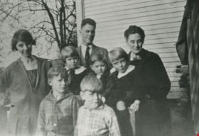
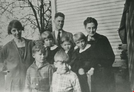
- Photograph of the William Rorison family. Front, left to right: Bill Rorison and Hugh Rorison. Middle, left to right: Alma Rorison, Kay Rorison, John Rorison, and Evelyn Rorison. Back, left to right: William Rorison and "Grandma" Cropley.
- Repository
- City of Burnaby Archives
- Date
- 1926 (date of original), copied 1986
- Collection/Fonds
- Burnaby Historical Society fonds
- Subseries
- Pioneer Tales subseries
- Physical Description
- 1 photograph : b&w ; 12.7 x 17.8 cm print
- Description Level
- Item
- Record No.
- 204-237
- Access Restriction
- No restrictions
- Reproduction Restriction
- No known restrictions
- Accession Number
- BHS1988-03
- Scope and Content
- Photograph of the William Rorison family. Front, left to right: Bill Rorison and Hugh Rorison. Middle, left to right: Alma Rorison, Kay Rorison, John Rorison, and Evelyn Rorison. Back, left to right: William Rorison and "Grandma" Cropley.
- Names
- Rorison, Alma
- Rorison, Bill
- Rorison, Evelyn
- Rorison, Hugh
- Rorison, Kay
- Rorison, John
- Rorison, William
- Media Type
- Photograph
- Notes
- Title based on contents of photograph
- Geographic Access
- Marine Drive
- Street Address
- 4593 Marine Drive
- Historic Neighbourhood
- Fraser Arm (Historic Neighbourhood)
- Planning Study Area
- Sussex-Nelson Area
Images
Rorison Family
https://search.heritageburnaby.ca/link/archivedescription35381
- Repository
- City of Burnaby Archives
- Date
- 1926 (date of original), copied 1986
- Collection/Fonds
- Burnaby Historical Society fonds
- Description Level
- Item
- Physical Description
- 1 photograph : b&w ; 12.7 x 17.8 cm print
- Scope and Content
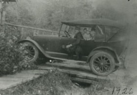
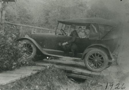
- Photograph of William Rorison and children in the family car, along River Road (now Marine Drive).
- Repository
- City of Burnaby Archives
- Date
- 1926 (date of original), copied 1986
- Collection/Fonds
- Burnaby Historical Society fonds
- Subseries
- Pioneer Tales subseries
- Physical Description
- 1 photograph : b&w ; 12.7 x 17.8 cm print
- Description Level
- Item
- Record No.
- 204-238
- Access Restriction
- No restrictions
- Reproduction Restriction
- No known restrictions
- Accession Number
- BHS1988-03
- Scope and Content
- Photograph of William Rorison and children in the family car, along River Road (now Marine Drive).
- Names
- Rorison, William
- Media Type
- Photograph
- Notes
- Title based on contents of photograph
- Geographic Access
- Marine Drive
- Street Address
- 4593 Marine Drive
- Historic Neighbourhood
- Fraser Arm (Historic Neighbourhood)
- Planning Study Area
- Sussex-Nelson Area
Images
Cutting down a Christmas tree
https://search.heritageburnaby.ca/link/archivedescription35382
- Repository
- City of Burnaby Archives
- Date
- 1925
- Collection/Fonds
- Burnaby Historical Society fonds
- Description Level
- Item
- Physical Description
- 1 photograph : b&w ; 12.7 x 17.8 cm print
- Scope and Content
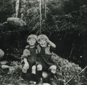
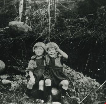
- Photograph of twin sisters, Kay and Evelyn Rorison, cutting down a Christmas tree. Kay and Evelyn were the daughters of William and Alma Rorison of 3907 River Road (later becoming 4593 Marine Drive at Strathern Avenue).
- Repository
- City of Burnaby Archives
- Date
- 1925
- Collection/Fonds
- Burnaby Historical Society fonds
- Subseries
- Pioneer Tales subseries
- Physical Description
- 1 photograph : b&w ; 12.7 x 17.8 cm print
- Description Level
- Item
- Record No.
- 204-239
- Access Restriction
- No restrictions
- Reproduction Restriction
- No known restrictions
- Accession Number
- BHS1988-03
- Scope and Content
- Photograph of twin sisters, Kay and Evelyn Rorison, cutting down a Christmas tree. Kay and Evelyn were the daughters of William and Alma Rorison of 3907 River Road (later becoming 4593 Marine Drive at Strathern Avenue).
- Subjects
- Plants - Trees
- Media Type
- Photograph
- Notes
- Title based on contents of photograph
- Geographic Access
- Marine Drive
- Street Address
- 4593 Marine Drive
- Historic Neighbourhood
- Fraser Arm (Historic Neighbourhood)
- Planning Study Area
- Sussex-Nelson Area
Images
Rorison Children
https://search.heritageburnaby.ca/link/archivedescription35383
- Repository
- City of Burnaby Archives
- Date
- 1926 (date of original), copied 1986
- Collection/Fonds
- Burnaby Historical Society fonds
- Description Level
- Item
- Physical Description
- 1 photograph : b&w ; 12.7 x 17.8 cm print
- Scope and Content
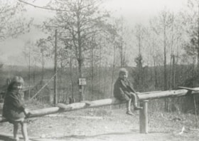
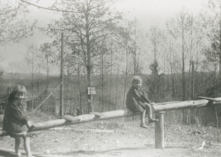
- Photograph of Kay Rorison, Evelyn Rorison (twin sisters), and John Rorison playing on a home-made teeter-totter beside the family home at 3907 River Road (later becoming 4593 Marine Drive at Strathern Avenue).
- Repository
- City of Burnaby Archives
- Date
- 1926 (date of original), copied 1986
- Collection/Fonds
- Burnaby Historical Society fonds
- Subseries
- Pioneer Tales subseries
- Physical Description
- 1 photograph : b&w ; 12.7 x 17.8 cm print
- Description Level
- Item
- Record No.
- 204-240
- Access Restriction
- No restrictions
- Reproduction Restriction
- No known restrictions
- Accession Number
- BHS1988-03
- Scope and Content
- Photograph of Kay Rorison, Evelyn Rorison (twin sisters), and John Rorison playing on a home-made teeter-totter beside the family home at 3907 River Road (later becoming 4593 Marine Drive at Strathern Avenue).
- Media Type
- Photograph
- Notes
- Title based on contents of photograph
- Geographic Access
- Marine Drive
- Street Address
- 4593 Marine Drive
- Historic Neighbourhood
- Fraser Arm (Historic Neighbourhood)
- Planning Study Area
- Sussex-Nelson Area
Images
![Rorison children, [1927] (date of original), copied 1986 thumbnail](/media/hpo/_Data/_Archives_Images/_Unrestricted/204/204-241.jpg?width=280)
Rorison children
https://search.heritageburnaby.ca/link/archivedescription35384
- Repository
- City of Burnaby Archives
- Date
- [1927] (date of original), copied 1986
- Collection/Fonds
- Burnaby Historical Society fonds
- Description Level
- Item
- Physical Description
- 1 photograph : b&w ; 12.7 x 17.8 cm print
- Scope and Content
- Photograph of Kay Rorison, Evelyn Rorison (twin sisters), and Bill Rorison on a home-made cart. The childrens' parents were William Rorison and Alma Rorison of 3907 River Road (later becoming 4593 Marine Drive at Strathern Avenue).
- Repository
- City of Burnaby Archives
- Date
- [1927] (date of original), copied 1986
- Collection/Fonds
- Burnaby Historical Society fonds
- Subseries
- Pioneer Tales subseries
- Physical Description
- 1 photograph : b&w ; 12.7 x 17.8 cm print
- Description Level
- Item
- Record No.
- 204-241
- Access Restriction
- No restrictions
- Reproduction Restriction
- No known restrictions
- Accession Number
- BHS1988-03
- Scope and Content
- Photograph of Kay Rorison, Evelyn Rorison (twin sisters), and Bill Rorison on a home-made cart. The childrens' parents were William Rorison and Alma Rorison of 3907 River Road (later becoming 4593 Marine Drive at Strathern Avenue).
- Subjects
- Transportation - Carts
- Media Type
- Photograph
- Notes
- Title based on contents of photograph
- Geographic Access
- Marine Drive
- Street Address
- 4593 Marine Drive
- Historic Neighbourhood
- Fraser Arm (Historic Neighbourhood)
- Planning Study Area
- Sussex-Nelson Area
Images
![Rorison children, [1927] (date of original), copied 1986 thumbnail](/media/hpo/_Data/_Archives_Images/_Unrestricted/204/204-241.jpg)
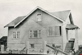
Phillips family home
https://search.heritageburnaby.ca/link/archivedescription35461
- Repository
- City of Burnaby Archives
- Date
- 1929 (date of original), copied 1986
- Collection/Fonds
- Burnaby Historical Society fonds
- Description Level
- Item
- Physical Description
- 1 photograph : b&w ; 12.7 x 17.8 cm print
- Scope and Content
- Photograph of the Phillips family home at 5670 Byrne Road, built in 1929. This was the home of John Phillips, his wife Lily Phillips (nee Warne) and their children. They owned and operated a large dairy (Victory Dairy). The dairy and cow barns were also on this property.
- Repository
- City of Burnaby Archives
- Date
- 1929 (date of original), copied 1986
- Collection/Fonds
- Burnaby Historical Society fonds
- Subseries
- Pioneer Tales subseries
- Physical Description
- 1 photograph : b&w ; 12.7 x 17.8 cm print
- Description Level
- Item
- Record No.
- 204-319
- Access Restriction
- No restrictions
- Reproduction Restriction
- No known restrictions
- Accession Number
- BHS1988-03
- Scope and Content
- Photograph of the Phillips family home at 5670 Byrne Road, built in 1929. This was the home of John Phillips, his wife Lily Phillips (nee Warne) and their children. They owned and operated a large dairy (Victory Dairy). The dairy and cow barns were also on this property.
- Subjects
- Buildings - Residential - Houses
- Media Type
- Photograph
- Notes
- Title based on contents of photograph
- Geographic Access
- Byrne Road
- Street Address
- 5670 Byrne Road
- Historic Neighbourhood
- Fraser Arm (Historic Neighbourhood)
- Planning Study Area
- Big Bend Area
Images
