Narrow Results By
Subject
- Advertising Medium - Signs and Signboards 2
- Agriculture - Farms 6
- Animals - Cows 3
- Animals - Horses 1
- Buildings - Agricultural - Nurseries 1
- Buildings - Commercial 5
- Buildings - Commercial - Offices 1
- Buildings - Heritage 1
- Buildings - Industrial 2
- Buildings - Industrial - Dairies 1
- Buildings - Public - Detention Facilities 1
- Buildings - Residential 1

Duncan & Margaret McGregor Estate 'Glen-Lyon' Mansion
https://search.heritageburnaby.ca/link/landmark518
- Repository
- Burnaby Heritage Planning
- Description
- Overlooking the rich farmland of the Fraser River floodplain, 'Glen-Lyon' is an Edwardian era rural estate, with a tall, two and one-half storey plus basement wood-frame mansion, set in a pastoral and formal landscape with an associated barn and early log pond, located near a ravine and forested ar…
- Associated Dates
- 1902
- Formal Recognition
- Heritage Designation, Community Heritage Register
- Street View URL
- Google Maps Street View
- Repository
- Burnaby Heritage Planning
- Geographic Access
- Marine Drive
- Associated Dates
- 1902
- Formal Recognition
- Heritage Designation, Community Heritage Register
- Enactment Type
- Bylaw No. 12183
- Enactment Date
- 11/12/2006
- Description
- Overlooking the rich farmland of the Fraser River floodplain, 'Glen-Lyon' is an Edwardian era rural estate, with a tall, two and one-half storey plus basement wood-frame mansion, set in a pastoral and formal landscape with an associated barn and early log pond, located near a ravine and forested area adjacent to Marine Drive in South Burnaby.
- Heritage Value
- ‘Glen-Lyon’ is valued as an excellent example of a privately-owned Edwardian era country estate built at the turn of the nineteenth century. The property retains significant heritage features including the Edwardian era mansion with rustic Arts and Crafts features, and elements of a working agricultural landscape. The property was originally the Royal City Mills logging camp, and in 1900 was purchased by Duncan Campbell McGregor (1853-1929) and Margaret Jane McGregor (1875-1960), who named their estate ‘Glen-Lyon’ after Duncan McGregor’s birthplace in Perthshire, Scotland. The McGregors were active in municipal affairs and social activities, and played a significant role in the early development of Burnaby. Duncan McGregor served as a city councillor from 1909 to 1912 and was elected reeve of Burnaby in 1913. Margaret McGregor was instrumental in the formation and fundraising activities of the Victoria Order of Nurses in Burnaby. Additionally, the site is historically significant for its association with early social welfare and correctional reform. The estate was sold in 1926 to an inter-denominational religious organization called the Home of the Friendless, which used it as their B.C. headquarters. The organization was charged with several cases of abuse and neglect in 1937, after which a Royal Commission was formed that led to new legislation to regulate and license all private welfare institutions. 'Glen-Lyon' was sold to the provincial government, and was dedicated in 1939 by the Lt.-Gov. E.W. Hamber for use as the New Haven Borstal Home for Boys and Youthful Offenders (later renamed the New Haven Correction Centre). The Borstal movement originated in England in the late nineteenth century, as an alternative to sending young offenders and runaways to prisons by providing reformatories that focused on discipline and vocational skill. This site’s role as the first North American institution devoted to the Borstal School philosophy was historic, and influenced corrections programs across Canada. The site retains significant features from its development in 1939 as the Borstal School, including a large gambrel-roofed barn designed by Chief Provincial Architect Henry Whittaker of the Department of Public Works that is the only remaining structure of its kind in Burnaby. Between 1941 and 1945 the mansion housed the Provincial School for the Deaf and Blind when the Borstal School was closed temporarily as a war measure during the Second World War.
- Defining Elements
- Key elements that define the heritage character of 'Glen-Lyon' Mansion include its: - location on a sloping site with expansive southern exposure, adjacent to Marine Drive - residential form, scale and massing of the house as exemplified by its two and one-half storey height, above-ground basement and rectangular plan - Arts and Crafts elements of the house such as its stone foundation, multi-gabled roof line with steep central hipped roof, symmetrical cross-gables, side shed dormers, bellcast upper walls sheathed in cedar shingles and lower walls sheathed in narrow clapboard - original exterior features of the house such as the full width front verandah with square columns, central staircase on the southern elevation, original doors and stained glass windows; and the irregular fenestration such as double-hung 1-over-1 wooden-sash windows, bay windows, and projecting windows in the gable ends - original interior features of the house such as the U-shaped main stair designed around two symmetrically placed Ionic columns, and interior trim on the main floor including boxed beams and fireplaces - gambrel-roofed barn with roof vent with finial, sliding hay loft and access doors, small multi-pane windows, and lapped wooden siding - associated landscape features such as the original garden plantings with some exotic and many native specimen trees; the original log pond and its concrete Marine Drive causeway and culvert; rockeries and a rose garden
- Historic Neighbourhood
- Fraser Arm (Historic Neighbourhood)
- Planning Study Area
- Big Bend Area
- Architect
- Henry Whittaker
- Function
- Primary Historic--Estate
- Community
- Burnaby
- Cadastral Identifier
- 003-004-661
- Boundaries
- 'Glen-Lyon' is comprised of a single residential lot located at 4250 Marine Drive, Burnaby.
- Area
- 230873.18
- Contributing Resource
- Building
- Ownership
- Private
- Names
- McGregor, Duncan C. (1853-1929)
- Whittaker, Henry
- Home of the Friendless
- Borstal School
- New Haven Correction Centre
- Subjects
- Buildings - Heritage
- Buildings - Residential - Houses
- Buildings - Public - Detention Facilities
- Buildings - Residential
- Street Address
- 4250 Marine Drive
- Street View URL
- Google Maps Street View
Images


Fraser Arm Neighbourhood
https://search.heritageburnaby.ca/link/landmark767
- Repository
- Burnaby Heritage Planning
- Associated Dates
- 1905-1924
- Heritage Value
- Fraser Arm - so named because there the tram crossed Gilley Avenue, running down to the North Arm of the Fraser River - was served by the River Road [Marine Drive] which traversed the municipality of Burnaby, leading to both New Westminster and Vancouver. This area did not experience a real estate boom during the 1909-1913 as did many other Burnaby neighbourhoods - in fact, by 1912, only three homes had been built along Riverway as it remained a predominantly agricultural area.
- Historic Neighbourhood
- Fraser Arm (Historic Neighbourhood)
- Planning Study Area
- Big Bend Area
Images


Riverway East School (aka Dundonald School)
https://search.heritageburnaby.ca/link/landmark769
- Repository
- Burnaby Heritage Planning
- Geographic Access
- Marine Drive
- Associated Dates
- 1905
- Heritage Value
- Burnaby's fourth school was originally called Dundonald school and was opened in 1905. The building cost $600.00 to erect and was built on a small clearing of land in the middle of what was described as a dense forest. The attendance in the first year consisted of 13 children from three families: the Byrne, Woolard and Thrussell families. The school was later renamed Riverway East School and was replaced in 1953 by Glenwood Elementary School.
- Historic Neighbourhood
- Fraser Arm (Historic Neighbourhood)
- Planning Study Area
- Big Bend Area
- Street Address
- 5787 Marine Drive
- Street View URL
- Google Maps Street View
Images


BCER Eburne Line
https://search.heritageburnaby.ca/link/landmark771
- Repository
- Burnaby Heritage Planning
- Associated Dates
- 1909
- Heritage Value
- In 1908, construction began on the British Columbia Electric Railway Eburne tramline which was to connect Eburne (now known as Marpole) with New Westminster. It opened on September 15, 1909 and its tracks were built across the bog of the Fraser Arm district with little regard to the fact that virtually no one lived there. However, within one year an hourly passenger service, a milk train and three-times weekly freight service used this level fast-running connector. With the completion of the Chilliwack interurban line and various other steam railroads which were funnelled onto this line it became one of the most important industrial freight lines in the Lower Mainland.
- Historic Neighbourhood
- Fraser Arm (Historic Neighbourhood)
- Planning Study Area
- Big Bend Area
Images


Big Bend Neighbourhood
https://search.heritageburnaby.ca/link/landmark840
- Repository
- Burnaby Heritage Planning
- Associated Dates
- 1955-2008
- Heritage Value
- The Big Bend Neighbourhood in Burnaby maintained its status as an important agricultural area in the City in the years following 1955 and it also solidified its role as a prime industrial and commercial district. In 1972, the Big Bend Development Plan was adopted by Council and soon thereafter, approximately 620 acres of land were incorporated into the Agricultural Land Reserve. These lands have been set aside for agricultural and limited recreation purposes. By the 2000s, 160 acres of land were considered highly productive agricultural areas, and over 400 acres of land had been secured as parkland, including the Fraser Foreshore Park. The area also developed large commercial and industrial districts including those at Marine Way/Boundary, the Glenlyon Estates, Riverfront Business Park, Burnaby Business Park, and Glenwood Industrial Estates.
- Historic Neighbourhood
- Fraser Arm (Historic Neighbourhood)
- Planning Study Area
- Big Bend Area
Images

![Big Bend flood, [1999] thumbnail](/media/hpo/_Data/_Archives_Images/_Unrestricted/535/535-3167-1.jpg?width=280)
Big Bend flood
https://search.heritageburnaby.ca/link/archivedescription98087
- Repository
- City of Burnaby Archives
- Date
- [1999]
- Collection/Fonds
- Burnaby NewsLeader photograph collection
- Description Level
- File
- Physical Description
- 3 photographs (tiff) : col.
- Scope and Content
- File contains photographs of unidentified people after a flood in the Big Bend area. Photographs depict a person standing in a farm field and adjusting a plant at Wing Wong's Nursery, and another person wearing a hard hat and posing with a construction vehicle.
- Repository
- City of Burnaby Archives
- Date
- [1999]
- Collection/Fonds
- Burnaby NewsLeader photograph collection
- Physical Description
- 3 photographs (tiff) : col.
- Description Level
- File
- Record No.
- 535-3167
- Access Restriction
- No restrictions
- Reproduction Restriction
- No restrictions
- Accession Number
- 2018-12
- Scope and Content
- File contains photographs of unidentified people after a flood in the Big Bend area. Photographs depict a person standing in a farm field and adjusting a plant at Wing Wong's Nursery, and another person wearing a hard hat and posing with a construction vehicle.
- Subjects
- Agriculture - Farms
- Buildings - Agricultural - Nurseries
- Construction Tools and Equipment
- Natural Phenomena - Floods
- Media Type
- Photograph
- Notes
- Title based on original file name
- Collected by editorial for use in a May 1999 issue of the Burnaby NewsLeader
- Geographic Access
- Marine Drive
- Street Address
- 4892 Marine Drive
- Historic Neighbourhood
- Fraser Arm (Historic Neighbourhood)
- Planning Study Area
- Big Bend Area
Images
![Big Bend flood, [1999] thumbnail](/media/hpo/_Data/_Archives_Images/_Unrestricted/535/535-3167-1.jpg)
![Environment Week at Terminus Park, [1999] thumbnail](/media/hpo/_Data/_Archives_Images/_Unrestricted/535/535-3201.jpg?width=280)
Environment Week at Terminus Park
https://search.heritageburnaby.ca/link/archivedescription98122
- Repository
- City of Burnaby Archives
- Date
- [1999]
- Collection/Fonds
- Burnaby NewsLeader photograph collection
- Description Level
- Item
- Physical Description
- 1 photograph (tiff) : col.
- Scope and Content
- Photograph of Clinton Elementary School students Felipe Castaneda and Corey Itterman pulling out purple loosestrife from around a pond in Terminus Park (Burnaby Fraser Foreshore Park), during Burnaby's Environment Week celebrations.
- Repository
- City of Burnaby Archives
- Date
- [1999]
- Collection/Fonds
- Burnaby NewsLeader photograph collection
- Physical Description
- 1 photograph (tiff) : col.
- Description Level
- Item
- Record No.
- 535-3201
- Access Restriction
- No restrictions
- Reproduction Restriction
- No restrictions
- Accession Number
- 2018-12
- Scope and Content
- Photograph of Clinton Elementary School students Felipe Castaneda and Corey Itterman pulling out purple loosestrife from around a pond in Terminus Park (Burnaby Fraser Foreshore Park), during Burnaby's Environment Week celebrations.
- Media Type
- Photograph
- Photographer
- Bartel, Mario
- Notes
- Title based on caption
- Collected by editorial for use in a June 1999 issue of the Burnaby NewsLeader
- Caption from metadata: "Felipe Castaneda, 12, and Corey Itterman, 12, team up to pull out purple loosestrife, from around the ponds at Terminus Park. They were part of a team of students from Clinton Elementary, and Douglas College, pulling weeds and planting new grasses and bushes at the fledgling park, as part of Burnaby's Environment Week celebrations."
- Geographic Access
- Burnaby Fraser Foreshore Park
- Historic Neighbourhood
- Fraser Arm (Historic Neighbourhood)
- Planning Study Area
- Big Bend Area
Images
![Environment Week at Terminus Park, [1999] thumbnail](/media/hpo/_Data/_Archives_Images/_Unrestricted/535/535-3201.jpg)
![Bike winner, [1999] thumbnail](/media/hpo/_Data/_Archives_Images/_Unrestricted/535/535-3269.jpg?width=280)
Bike winner
https://search.heritageburnaby.ca/link/archivedescription98191
- Repository
- City of Burnaby Archives
- Date
- [1999]
- Collection/Fonds
- Burnaby NewsLeader photograph collection
- Description Level
- Item
- Physical Description
- 1 photograph (tiff) : b&w
- Scope and Content
- Photograph of an unidentified child and an adult posing with a bicycle outside of the NewsLeader office.
- Repository
- City of Burnaby Archives
- Date
- [1999]
- Collection/Fonds
- Burnaby NewsLeader photograph collection
- Physical Description
- 1 photograph (tiff) : b&w
- Description Level
- Item
- Record No.
- 535-3269
- Access Restriction
- No restrictions
- Reproduction Restriction
- No restrictions
- Accession Number
- 2018-12
- Scope and Content
- Photograph of an unidentified child and an adult posing with a bicycle outside of the NewsLeader office.
- Media Type
- Photograph
- Notes
- Title based on original file name
- Collected by editorial for use in a July 1999 issue of the Burnaby NewsLeader
- Geographic Access
- Fraser Park Drive
- Historic Neighbourhood
- Fraser Arm (Historic Neighbourhood)
- Planning Study Area
- Big Bend Area
Images
![Bike winner, [1999] thumbnail](/media/hpo/_Data/_Archives_Images/_Unrestricted/535/535-3269.jpg)
![Lightning strike, [1999] thumbnail](/media/hpo/_Data/_Archives_Images/_Unrestricted/535/535-3279.jpg?width=280)
Lightning strike
https://search.heritageburnaby.ca/link/archivedescription98201
- Repository
- City of Burnaby Archives
- Date
- [1999]
- Collection/Fonds
- Burnaby NewsLeader photograph collection
- Description Level
- Item
- Physical Description
- 1 photograph (tiff) : col.
- Scope and Content
- Photograph of paramedics moving a person on a stretcher into an ambulance as another unidentified person looks on, after a Burnaby worker was hit by lightning at the Riverway Golf Course. A grassy field and body of water are visible in the background.
- Repository
- City of Burnaby Archives
- Date
- [1999]
- Collection/Fonds
- Burnaby NewsLeader photograph collection
- Physical Description
- 1 photograph (tiff) : col.
- Description Level
- Item
- Record No.
- 535-3279
- Access Restriction
- No restrictions
- Reproduction Restriction
- No restrictions
- Accession Number
- 2018-12
- Scope and Content
- Photograph of paramedics moving a person on a stretcher into an ambulance as another unidentified person looks on, after a Burnaby worker was hit by lightning at the Riverway Golf Course. A grassy field and body of water are visible in the background.
- Names
- Riverway Golf Course
- Media Type
- Photograph
- Notes
- Title based on original file name
- Collected by editorial for use in an August 1999 issue of the Burnaby NewsLeader
- Geographic Access
- Bill Fox Way
- Street Address
- 9001 Bill Fox Way
- Historic Neighbourhood
- Fraser Arm (Historic Neighbourhood)
- Planning Study Area
- Big Bend Area
Images
![Lightning strike, [1999] thumbnail](/media/hpo/_Data/_Archives_Images/_Unrestricted/535/535-3279.jpg)
![Finn Donnelly at the Swim for Salmon, [1999] thumbnail](/media/hpo/_Data/_Archives_Images/_Unrestricted/535/535-3346-1.jpg?width=280)
Finn Donnelly at the Swim for Salmon
https://search.heritageburnaby.ca/link/archivedescription98322
- Repository
- City of Burnaby Archives
- Date
- [1999]
- Collection/Fonds
- Burnaby NewsLeader photograph collection
- Description Level
- File
- Physical Description
- 2 photographs (tiff) : col.
- Scope and Content
- File contains photographs of marathon swimmer Finn Donnelly at Fraser Foreshore Park after completing the second leg of the Swim for Salmon event as part of BC Rivers Day. Photographs depict Donnelly posing on the shore and helping unidentified members of his crew to move canoes out of the Fraser R…
- Repository
- City of Burnaby Archives
- Date
- [1999]
- Collection/Fonds
- Burnaby NewsLeader photograph collection
- Physical Description
- 2 photographs (tiff) : col.
- Description Level
- File
- Record No.
- 535-3346
- Access Restriction
- No restrictions
- Reproduction Restriction
- No restrictions
- Accession Number
- 2018-12
- Scope and Content
- File contains photographs of marathon swimmer Finn Donnelly at Fraser Foreshore Park after completing the second leg of the Swim for Salmon event as part of BC Rivers Day. Photographs depict Donnelly posing on the shore and helping unidentified members of his crew to move canoes out of the Fraser River.
- Media Type
- Photograph
- Photographer
- Bartel, Mario
- Notes
- Title based on caption
- Collected by editorial for use in a September 1999 issue of the Burnaby NewsLeader
- Caption from metadata for 535-3346-1: "Marathon swimmer Finn Donnelly emerges from the Fraser River at Foreshare Park, after completing the second leg of his Swim for the Salmon to mark BC Rivers Day."
- Caption from metadata for 535-3346-2: "Marathon swimmer Finn Donnelly helps bring ashore some of the voyageur canoes which accompanied him on the second leg of his Swim for the Salmon, on the Fraser River from New West Quay to Foreshore Park."
- Geographic Access
- Fraser River
- Burnaby Fraser Foreshore Park
- Historic Neighbourhood
- Fraser Arm (Historic Neighbourhood)
- Planning Study Area
- Big Bend Area
Images
![Finn Donnelly at the Swim for Salmon, [1999] thumbnail](/media/hpo/_Data/_Archives_Images/_Unrestricted/535/535-3346-1.jpg)
![U11 boys' soccer game, [1999] thumbnail](/media/hpo/_Data/_Archives_Images/_Unrestricted/535/535-3354.jpg?width=280)
U11 boys' soccer game
https://search.heritageburnaby.ca/link/archivedescription98344
- Repository
- City of Burnaby Archives
- Date
- [1999]
- Collection/Fonds
- Burnaby NewsLeader photograph collection
- Description Level
- Item
- Physical Description
- 1 photograph (tiff) : col.
- Scope and Content
- Photograph of two unidentified players in action during a U11 boys' soccer game between the Scorpions and the Predators at Riverway Park.
- Repository
- City of Burnaby Archives
- Date
- [1999]
- Collection/Fonds
- Burnaby NewsLeader photograph collection
- Physical Description
- 1 photograph (tiff) : col.
- Description Level
- Item
- Record No.
- 535-3354
- Access Restriction
- No restrictions
- Reproduction Restriction
- No restrictions
- Accession Number
- 2018-12
- Scope and Content
- Photograph of two unidentified players in action during a U11 boys' soccer game between the Scorpions and the Predators at Riverway Park.
- Subjects
- Persons - Children
- Sports - Soccer
- Media Type
- Photograph
- Photographer
- Bartel, Mario
- Notes
- Title based on caption
- Collected by editorial for use in an October 1999 issue of the Burnaby NewsLeader
- Caption from metadata: "A Scorpions' defender (dark jersey) tries to check the ball away from his Predators' opponent in boys' U-11 soccer at Riverway Park."
- Geographic Access
- Riverway Sports Complex
- Marine Drive
- Historic Neighbourhood
- Fraser Arm (Historic Neighbourhood)
- Planning Study Area
- Big Bend Area
Images
![U11 boys' soccer game, [1999] thumbnail](/media/hpo/_Data/_Archives_Images/_Unrestricted/535/535-3354.jpg)
![Burnaby Canadians U21 soccer game, [1999] thumbnail](/media/hpo/_Data/_Archives_Images/_Unrestricted/535/535-3370.jpg?width=280)
Burnaby Canadians U21 soccer game
https://search.heritageburnaby.ca/link/archivedescription98360
- Repository
- City of Burnaby Archives
- Date
- [1999]
- Collection/Fonds
- Burnaby NewsLeader photograph collection
- Description Level
- Item
- Physical Description
- 1 photograph (tiff) : col.
- Scope and Content
- Photograph of unidentified players in action during a Vancouver Metro U21 soccer game between the Burnaby Canadians and Club Ireland Hibs at Riverway Park.
- Repository
- City of Burnaby Archives
- Date
- [1999]
- Collection/Fonds
- Burnaby NewsLeader photograph collection
- Physical Description
- 1 photograph (tiff) : col.
- Description Level
- Item
- Record No.
- 535-3370
- Access Restriction
- No restrictions
- Reproduction Restriction
- No restrictions
- Accession Number
- 2018-12
- Scope and Content
- Photograph of unidentified players in action during a Vancouver Metro U21 soccer game between the Burnaby Canadians and Club Ireland Hibs at Riverway Park.
- Subjects
- Sports - Soccer
- Media Type
- Photograph
- Photographer
- Bartel, Mario
- Notes
- Title based on caption
- Collected by editorial for use in an October 1999 issue of the Burnaby NewsLeader
- Caption from metadata: "A Burnaby Canadians' forward uses some fancy footwork to avoid a tackle in Vancouver Metro U-21 soccer action against Club Ireland Hibs, at Riverway Park."
- Geographic Access
- Riverway Sports Complex
- Marine Drive
- Historic Neighbourhood
- Fraser Arm (Historic Neighbourhood)
- Planning Study Area
- Big Bend Area
Images
![Burnaby Canadians U21 soccer game, [1999] thumbnail](/media/hpo/_Data/_Archives_Images/_Unrestricted/535/535-3370.jpg)
![Thrussell's farm, [1900] thumbnail](/media/hpo/_Data/_Archives_Images/_Unrestricted/251/275-001.jpg?width=280)
Thrussell's farm
https://search.heritageburnaby.ca/link/archivedescription36470
- Repository
- City of Burnaby Archives
- Date
- [1900]
- Collection/Fonds
- Burnaby Historical Society fonds
- Description Level
- Item
- Physical Description
- 1 photograph : b&w ; 8.5 x 12.5 cm print
- Scope and Content
- Photograph of the North Arm Dairy and the rest of the Thrussell family farm at Marine Drive and Nelson Avenue. Froggers Creek is visible on the left.
- Repository
- City of Burnaby Archives
- Date
- [1900]
- Collection/Fonds
- Burnaby Historical Society fonds
- Subseries
- Thrussell family subseries
- Physical Description
- 1 photograph : b&w ; 8.5 x 12.5 cm print
- Description Level
- Item
- Record No.
- 275-001
- Access Restriction
- No restrictions
- Reproduction Restriction
- No known restrictions
- Accession Number
- BHS1992-05
- Scope and Content
- Photograph of the North Arm Dairy and the rest of the Thrussell family farm at Marine Drive and Nelson Avenue. Froggers Creek is visible on the left.
- Names
- North Arm Dairy
- Media Type
- Photograph
- Notes
- Title based on contents of photograph
- Geographic Access
- Marine Drive
- Nelson Avenue
- Historic Neighbourhood
- Fraser Arm (Historic Neighbourhood)
- Planning Study Area
- Big Bend Area
Images
![Thrussell's farm, [1900] thumbnail](/media/hpo/_Data/_Archives_Images/_Unrestricted/251/275-001.jpg)
![North Arm Dairy, [1905] thumbnail](/media/hpo/_Data/_Archives_Images/_Unrestricted/251/275-005.jpg?width=280)
North Arm Dairy
https://search.heritageburnaby.ca/link/archivedescription36473
- Repository
- City of Burnaby Archives
- Date
- [1905]
- Collection/Fonds
- Burnaby Historical Society fonds
- Description Level
- Item
- Physical Description
- 1 photograph : b&w ; 8.5 x 12.5 cm print
- Scope and Content
- Photograph of the North Arm Dairy, the Thrussell farm and family business. Half a dozen cows are walking towards the barn as the children mingle around them. The large barn is in the center, and the North Arm Dairy wagon is visible in the background.
- Repository
- City of Burnaby Archives
- Date
- [1905]
- Collection/Fonds
- Burnaby Historical Society fonds
- Subseries
- Thrussell family subseries
- Physical Description
- 1 photograph : b&w ; 8.5 x 12.5 cm print
- Description Level
- Item
- Record No.
- 275-005
- Access Restriction
- No restrictions
- Reproduction Restriction
- No known restrictions
- Accession Number
- BHS1992-05
- Scope and Content
- Photograph of the North Arm Dairy, the Thrussell farm and family business. Half a dozen cows are walking towards the barn as the children mingle around them. The large barn is in the center, and the North Arm Dairy wagon is visible in the background.
- Subjects
- Agriculture - Farms
- Animals - Cows
- Names
- North Arm Dairy
- Media Type
- Photograph
- Notes
- Title based on contents of photograph
- Geographic Access
- Marine Drive
- Nelson Avenue
- Historic Neighbourhood
- Fraser Arm (Historic Neighbourhood)
- Planning Study Area
- Big Bend Area
Images
![North Arm Dairy, [1905] thumbnail](/media/hpo/_Data/_Archives_Images/_Unrestricted/251/275-005.jpg)
![North Arm Dairy, [1905] thumbnail](/media/hpo/_Data/_Archives_Images/_Unrestricted/251/275-006.jpg?width=280)
North Arm Dairy
https://search.heritageburnaby.ca/link/archivedescription36474
- Repository
- City of Burnaby Archives
- Date
- [1905]
- Collection/Fonds
- Burnaby Historical Society fonds
- Description Level
- Item
- Physical Description
- 1 photograph : b&w ; 8.5 x 12.5 cm print
- Scope and Content
- Photograph of the North Arm Dairy, the Thrussell farm and family business. The family is standing in front of the garage that houses the North Arm Diary wagon. The younger Frederick is standing with his arm across his brow, blocking the sun. His two sisters Ethel and Mary Anne are beside him. Eva i…
- Repository
- City of Burnaby Archives
- Date
- [1905]
- Collection/Fonds
- Burnaby Historical Society fonds
- Subseries
- Thrussell family subseries
- Physical Description
- 1 photograph : b&w ; 8.5 x 12.5 cm print
- Description Level
- Item
- Record No.
- 275-006
- Access Restriction
- No restrictions
- Reproduction Restriction
- No known restrictions
- Accession Number
- BHS1992-05
- Scope and Content
- Photograph of the North Arm Dairy, the Thrussell farm and family business. The family is standing in front of the garage that houses the North Arm Diary wagon. The younger Frederick is standing with his arm across his brow, blocking the sun. His two sisters Ethel and Mary Anne are beside him. Eva is standing beside her mother Harriett, who has baby Edith in her arms. The elder Frederick is standing front and center. Another man stands off to the right. In the distance, half a dozen cows are walking towards the barn.
- Subjects
- Agriculture - Farms
- Animals - Cows
- Names
- North Arm Dairy
- Thrussell, Frederick T.
- Thrussell, Ethel
- Welsh, Mary Anne "Annie" Thrussell Phillips
- Thrussell, Eva
- Thrussell, Harriett Fenwick
- Cleghorn, Edith Thrussell
- Thrussell, Fredrick (1869-1909)
- Media Type
- Photograph
- Notes
- Title based on contents of photograph
- Geographic Access
- Marine Drive
- Nelson Avenue
- Historic Neighbourhood
- Fraser Arm (Historic Neighbourhood)
- Planning Study Area
- Big Bend Area
Images
![North Arm Dairy, [1905] thumbnail](/media/hpo/_Data/_Archives_Images/_Unrestricted/251/275-006.jpg)
![North Arm Dairy, [1907] thumbnail](/media/hpo/_Data/_Archives_Images/_Unrestricted/251/275-007.jpg?width=280)
North Arm Dairy
https://search.heritageburnaby.ca/link/archivedescription36475
- Repository
- City of Burnaby Archives
- Date
- [1907]
- Collection/Fonds
- Burnaby Historical Society fonds
- Description Level
- Item
- Physical Description
- 1 photograph : b&w ; 8.5 x 12.5 cm print
- Scope and Content
- Photograph of the North Arm Dairy, the Thrussell farm and family business. A young child is sitting on one of the horses that is harnessed to the dairy wagon. The other horse has no rider, but a girl is holding on to the riens and sitting in the dairy wagon. A man is standing beside the horse with …
- Repository
- City of Burnaby Archives
- Date
- [1907]
- Collection/Fonds
- Burnaby Historical Society fonds
- Subseries
- Thrussell family subseries
- Physical Description
- 1 photograph : b&w ; 8.5 x 12.5 cm print
- Description Level
- Item
- Record No.
- 275-007
- Access Restriction
- No restrictions
- Reproduction Restriction
- No known restrictions
- Accession Number
- BHS1992-05
- Scope and Content
- Photograph of the North Arm Dairy, the Thrussell farm and family business. A young child is sitting on one of the horses that is harnessed to the dairy wagon. The other horse has no rider, but a girl is holding on to the riens and sitting in the dairy wagon. A man is standing beside the horse with the rider, holding his reins. Two cows are standing in front of the barn, along with a woman who is holding a child in her arms.
- Names
- North Arm Dairy
- Media Type
- Photograph
- Notes
- Title based on contents of photograph
- Geographic Access
- Marine Drive
- Nelson Avenue
- Historic Neighbourhood
- Fraser Arm (Historic Neighbourhood)
- Planning Study Area
- Big Bend Area
Images
![North Arm Dairy, [1907] thumbnail](/media/hpo/_Data/_Archives_Images/_Unrestricted/251/275-007.jpg)
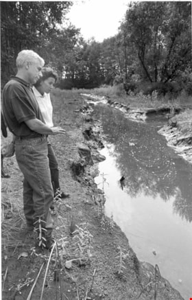
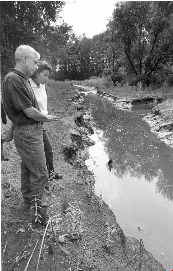
Kevin Conlin with Susan Haid
https://search.heritageburnaby.ca/link/archivedescription78559
- Repository
- City of Burnaby Archives
- Date
- October 1, 1995
- Collection/Fonds
- Burnaby NewsLeader photograph collection
- Description Level
- Item
- Physical Description
- 1 photograph : b&w ; 22.5 x 14.5 cm
- Scope and Content
- Photograph of Federal fisheries biologist Kevin Conlin with Burnaby environmental planner Susan Haid at salmon rearing area in Big Bend.
- Repository
- City of Burnaby Archives
- Date
- October 1, 1995
- Collection/Fonds
- Burnaby NewsLeader photograph collection
- Physical Description
- 1 photograph : b&w ; 22.5 x 14.5 cm
- Description Level
- Item
- Record No.
- 535-0003
- Access Restriction
- No restrictions
- Reproduction Restriction
- No reproduction permitted
- Accession Number
- 2012-11
- Scope and Content
- Photograph of Federal fisheries biologist Kevin Conlin with Burnaby environmental planner Susan Haid at salmon rearing area in Big Bend.
- Subjects
- Geographic Features - Creeks
- Names
- Conlin, Kevin
- Haid, Susan
- Media Type
- Photograph
- Photographer
- Ray, Steve
- Notes
- Title based on contents of photograph
- Note in black ink on recto of photograph reads: "Crop 65% / Bby pg 1 / Crop from top / Bby Steve Ray 2365C / 10/01 Bby/NW pg 9 - 104%"
- Trim marks and/or reproduction instructions on recto (scan is cropped)
- Historic Neighbourhood
- Fraser Arm (Historic Neighbourhood)
- Planning Study Area
- Big Bend Area
Images

North Fraser Harbour Commission / Fraser River
https://search.heritageburnaby.ca/link/archivedescription91706
- Repository
- City of Burnaby Archives
- Date
- May 25, 1994
- Collection/Fonds
- Doreen Lawson fonds
- Description Level
- File
- Physical Description
- 40 photographs : col. slides ; 35 mm + 65 photographs : col. negatives ; 35 mm
- Scope and Content
- File consists of photographs of the Fraser River. Sawmills and industrial buildings line the banks of the river which is populated with tugboats, drifting timber rafts, and sawdust barges. Photographs were taken from a boat travelling down the river and the bow of the boat is visible in one of th…
- Repository
- City of Burnaby Archives
- Date
- May 25, 1994
- Collection/Fonds
- Doreen Lawson fonds
- Physical Description
- 40 photographs : col. slides ; 35 mm + 65 photographs : col. negatives ; 35 mm
- Description Level
- File
- Record No.
- 618-024
- Access Restriction
- No restrictions
- Reproduction Restriction
- Reproduce for fair dealing purposes only
- Accession Number
- 2015-15
- Scope and Content
- File consists of photographs of the Fraser River. Sawmills and industrial buildings line the banks of the river which is populated with tugboats, drifting timber rafts, and sawdust barges. Photographs were taken from a boat travelling down the river and the bow of the boat is visible in one of the photographs.
- Media Type
- Photograph
- Notes
- Transcribed title
- Title transcribed from label on slide sheets
- Note in blue ink on recto of slide sheets photographs 618-024-001 : 618-024-15 and 618-024-27 : 618-024-38 were originally housed in read: "May 25 94 / North Fraser Harbour Commission / Fraser River"
- Note in blue ink on recto of slide sheet photographs 618-024-16 : 618-024-26 were originally housed in reads: "May 25 94 / North Fraser Harbour Commission / Fraser River / Irene Frith"
- Note in blue ink on slide sheet photographs 618-039 : 618-039-40 originally housed in read: "Fraser River / May 25 94"
- Note in blue ink on negative envelopes reads: "Fraser River / May 25 94"
- Geographic Access
- Fraser River
- Historic Neighbourhood
- Fraser Arm (Historic Neighbourhood)
- Planning Study Area
- Big Bend Area
Images

5324 Thorne Ave
https://search.heritageburnaby.ca/link/archivedescription93762
- Repository
- City of Burnaby Archives
- Date
- June 12, 1992
- Collection/Fonds
- Grover, Elliott & Co. Ltd. fonds
- Description Level
- File
- Physical Description
- 120 photographs : col. negatives ; 35 mm
- Scope and Content
- Photographs of an industrial property located at 5324 Thorne Avenue - an address than no longer exists.
- Repository
- City of Burnaby Archives
- Date
- June 12, 1992
- Collection/Fonds
- Grover, Elliott & Co. Ltd. fonds
- Physical Description
- 120 photographs : col. negatives ; 35 mm
- Description Level
- File
- Record No.
- 622-047
- Access Restriction
- No restrictions
- Reproduction Restriction
- No restrictions
- Accession Number
- 2017-39
- Scope and Content
- Photographs of an industrial property located at 5324 Thorne Avenue - an address than no longer exists.
- Subjects
- Buildings - Industrial
- Media Type
- Photograph
- Notes
- Transcribed title
- Title transcribed from envelope photographs were originally housed in
- File no. 92-224-I
- Note adhered to 622-047-001 print reads: "11 / The manufacturing plant [illegible], southwest from the northweast corner of the site".
- Note adhered to 622-047-5 print reads: "17 / view south along the east side of the property from Thorne Avenue".
- Note adhered to 622-047-9 print reads: "18 / The canopy at loading area and shed addition of the [illegible] and of the building".
- Note adhered to 622-047-13 print reads: "19 / View of the interior of the building looking towards to west".
- Note adhered to 622-047-17 print reads: "23 / view east across the site immediately south of the building".
- Note adhered to 622-047-21 print reads: "22 / view looking north west twoards the south facade".
- Note adhered to 622-047-25 print reads: "8 / The freestanding office building adjacent to Thorne Avenue and Wiggins Street".
- Note adhered to 622-047-29 print reads: "9 / View of its front entr [sid] and the office building".
- Note adhered to 622-047-33 reads: "10 / View west towards the office building from the main vehicle entr [sic] at Thorne Avenue".
- Note adhered to 622-047-37 print reads: "14 / View east across the north yard area".
- Note adhered to 622-047-41 print reads: "12 / View of the north facade looking south."
- Note adhered to 622-047-45 print reads: "13 / View west across the north yard area".
- Note adhered to 622-047-49 print reads: "20 / The [illegible] building".
- Note adhered to 622-047-53 print reads: "26 / View northeast from the west property line".
- Note adhered to 622-047-57 print reads: "21 / View looking northeast at the south facade".
- Note adhered to 622-047-61 print reads: "16 / View north along the west side of the manufacturing building".
- Note adhered to 622-047-65 print reads: "15 / View of the north west corner of the manufacturing building".
- Note adhered to 622-047-69 print reads: "3 / View west along Thorne Avenue from the east side of the property".
- Note adhered to 622-047-73 print reads: "25 / View north from the southeast corner of the property".
- Note adhered to 622-047-77 print reads: "30 / View of the dock looking southeast from the property".
- Note adhered to 622-047-81 print reads: "24 / View north from the southwest corner of the property".
- Note adhered to 622-047-85 print reads: "27 / The barge dock at the southwest corner of the site".
- Note adhered to 622-047-89 print reads: "29 / View east along the river front".
- Note adhered to 622-047-93 print reads: "28 / View of the dolphins and mooring area".
- Note adhered to 622-047-97 print reads: "4 / View west along [illegible] Avenue past the entrance to the north parking lot".
- Note adhered to 622-047-101 print reads: "2 / View southwest from Thorne Avenue".
- Note adhered to 622-047-105 print reads: "5 / View west across the north parking lot".
- Note adhered to 622-047-113 print reads: "6 / View southeast from the north parking lot".
- Photographer identified as "D.E."
- Geographic Access
- Thorne Avenue
- Historic Neighbourhood
- Fraser Arm (Historic Neighbourhood)
- Planning Study Area
- Big Bend Area
106-7450 lowland [sic] dr
https://search.heritageburnaby.ca/link/archivedescription93811
- Repository
- City of Burnaby Archives
- Date
- September 1992
- Collection/Fonds
- Grover, Elliott & Co. Ltd. fonds
- Description Level
- File
- Physical Description
- 17 photographs : col. negative ; 35 mm
- Scope and Content
- Photographs of the exterior of a two-storey commercial building located 7450 Lowland Drive. Tenant businesses visible in the photographs include Dura-Log and Kango.
- Repository
- City of Burnaby Archives
- Date
- September 1992
- Collection/Fonds
- Grover, Elliott & Co. Ltd. fonds
- Physical Description
- 17 photographs : col. negative ; 35 mm
- Description Level
- File
- Record No.
- 622-059
- Access Restriction
- No restrictions
- Reproduction Restriction
- No restrictions
- Accession Number
- 2017-39
- Scope and Content
- Photographs of the exterior of a two-storey commercial building located 7450 Lowland Drive. Tenant businesses visible in the photographs include Dura-Log and Kango.
- Subjects
- Buildings - Commercial - Offices
- Media Type
- Photograph
- Notes
- Transcribed title
- Title transcribed from envelope photographs were originally housed in
- File no. 92-346-B
- Geographic Access
- Lowland Drive
- Street Address
- 7450 Lowland Drive
- Historic Neighbourhood
- Fraser Arm (Historic Neighbourhood)
- Planning Study Area
- Big Bend Area