Narrow Results By
Person / Organization
- Avendaño, Adrian 1
- Boal, Ethel May Jackson 4
- Boal, Glen 6
- Boal, Thomas "Tom" 2
- Boal, William Ewart 4
- British Columbia Electric Railway Company 8
- British Columbia Hydro and Power Authority 1
- Brownlee, James Harrison 1
- Burnaby Central Secondary School 20
- Burnaby Fire Department 1
- Burnaby Lake Nature House 4
- Burnaby Lake Rowing Pavilion 15

Mortimer-Lamb House
https://search.heritageburnaby.ca/link/landmark494
- Repository
- Burnaby Heritage Planning
- Description
- The Mortimer-Lamb House is a one and one half-storey, Arts and Crafts-style residence with a steeply pitched, side-gabled roof. The original cottage form has been enlarged with a later addition on the west side of the house. Located next to the Burnaby Lake Regional Park Wildlife Rescue Care Centre…
- Associated Dates
- c.1922
- Formal Recognition
- Community Heritage Register
- Other Names
- Harold & Katherine Mortimer-Lamb Residence
- Street View URL
- Google Maps Street View
- Repository
- Burnaby Heritage Planning
- Other Names
- Harold & Katherine Mortimer-Lamb Residence
- Geographic Access
- Glencarin Drive
- Associated Dates
- c.1922
- Formal Recognition
- Community Heritage Register
- Enactment Type
- Council Resolution
- Enactment Date
- 26/05/2003
- Description
- The Mortimer-Lamb House is a one and one half-storey, Arts and Crafts-style residence with a steeply pitched, side-gabled roof. The original cottage form has been enlarged with a later addition on the west side of the house. Located next to the Burnaby Lake Regional Park Wildlife Rescue Care Centre, the house has picturesque views of Burnaby Lake.
- Heritage Value
- Built circa 1922, the Mortimer-Lamb House is valued for its association with first owners, Harold Mortimer-Lamb (1872-1970), and his wife, Katherine Mary Mortimer-Lamb (1873-1939). Born in Leatherhead, Surrey, England, Harold Mortimer-Lamb immigrated to Canada in 1889. Seven years later in Vancouver, he married Katherine Mary Lindsay, a native of Winnipeg. Mortimer-Lamb was a key figure in the B.C. mining industry, serving as Secretary of the Mining Association of B.C. between 1900 and 1945, and also as the Secretary of the Canadian Institute of Mining and Metallurgy. In addition to his professional life, Mortimer-Lamb was a pioneer art photographer and was among Canada's leading art critics, and this house served as a central gathering place for renowned Canadian artists of the day. Mortimer-Lamb’s daughter, Molly Lamb Bobak (born 1922), became a renowned watercolourist, and was the only woman ever hired as an official Canadian war artist. The Mortimer-Lamb House is a significant example of the work of noted architect, Samuel Maclure (1860-1929) and his partner, Ross Lort (1889-1969). Maclure, who was a close friend of the Mortimer-Lamb family, was British Columbia's leading residential architect, and was renowned for his high quality designs for prominent citizens in both Vancouver and Victoria. Maclure was a leading exponent of the Art and Crafts design movement in B.C., and established a sophisticated local variation of residential architecture. The Mortimer-Lamb House was designed at the time when Maclure was in partnership with Ross Lort. In 1907, Lort began working for Maclure's firm as a draftsman, and by 1920 was in charge of Maclure's Vancouver office. Lort's architectural career spanned some sixty-years, and he designed some of the province's most familiar houses, apartments, institutions and places of worship. The Mortimer-Lamb House is also a significant local example of the Arts and Crafts style, and incorporates elements such as board-and-batten siding on the ground floor, shingled gables and leaded casement windows. It is a testament to the domestic architecture built outside of established suburbs during the post-First World War era, typically modest in scale and representative of middle-class residential ideals.
- Defining Elements
- Key elements that define the heritage character of the Mortimer-Lamb House include its: - treed setting with views of Burnaby Lake - residential form, scale and massing as expressed by its one and one-half storey height, rectangular plan and steeply pitched side-gabled roof - wood-frame construction - Arts and Crafts elements such as board-and-batten siding on the ground floor, cedar shingles in the gables and open soffits - original straight-leaded casement windows in single and multiple-assembly - internal red-brick chimney with corbelled cap
- Historic Neighbourhood
- Burnaby Lake (Historic Neighbourhood)
- Planning Study Area
- Burnaby Lake Area
- Organization
- Mining Association of B.C.
- G.F. and J. Galt Limited
- Architect
- Samuel Maclure
- Ross Lort
- Function
- Primary Historic--Single Dwelling
- Primary Current--Single Dwelling
- Community
- Burnaby Lake
- Cadastral Identifier
- P.I.D.002-977-788
- Boundaries
- The Mortimer-Lamb House is comprised of a single residential lot located at 5180 Glencairn Drive, Burnaby.
- Area
- 5652.78
- Contributing Resource
- Building
- Ownership
- Private
- Documentation
- City of Burnaby Planning and Building Department, Heritage Site Files
- Street Address
- 5180 Glencarin Drive
- Street View URL
- Google Maps Street View
Images


Stanley & Isabel Picken House 'Aintree'
https://search.heritageburnaby.ca/link/landmark519
- Repository
- Burnaby Heritage Planning
- Description
- Nestled within a stand of deciduous trees, the Stanley and Isabel Picken House 'Aintree' is a two and one-half storey plus basement shingled and half-timbered Arts and Crafts influenced residence, set on its original 0.6 hectare site adjacent to Brunette Creek in the Burnaby Lake Regional Nature Pa…
- Associated Dates
- 1929
- Formal Recognition
- Heritage Designation, Community Heritage Register
- Street View URL
- Google Maps Street View
- Repository
- Burnaby Heritage Planning
- Geographic Access
- Cariboo Road
- Associated Dates
- 1929
- Formal Recognition
- Heritage Designation, Community Heritage Register
- Enactment Type
- Bylaw No. 11756
- Enactment Date
- 09/08//2004
- Description
- Nestled within a stand of deciduous trees, the Stanley and Isabel Picken House 'Aintree' is a two and one-half storey plus basement shingled and half-timbered Arts and Crafts influenced residence, set on its original 0.6 hectare site adjacent to Brunette Creek in the Burnaby Lake Regional Nature Park.
- Heritage Value
- 'Aintree' is an example of the type of private country estate residences built in Burnaby outside of the established suburbs during the 1920s, and is representative of middle-class residential life during this time. Stanley Boyd Picken (1890-1950) and Isabel Grace Frederique Picken (1893-1971) purchased this property in 1927 to establish the Aintree Dog Kennels, which was the first in the province to breed Irish Setters. This country residence was completed in 1929. Stanley Picken worked at a variety of other jobs including his position as keeper of the Brunette River Caribou Dam. Considered a fine example of romantic architecture, 'Aintree' stands in harmony with its woodland setting. The north wing was added in a compatible style in 1932 using former bridge support beams from the old Caribou Road Bridge for foundation support. 'Aintree' retains most of its original exterior elements including its picturesque shingled siding and half-timbering, demonstrating the late influence of an Arts and Crafts sensibility considered compatible with a country lifestyle.
- Defining Elements
- Key elements that define the heritage character of 'Aintree' include its: - woodland setting adjacent to Brunette Creek in the Burnaby Lake Regional Nature Park, with a deep setback from Cariboo Road - residential form, scale and massing as exemplified by its asymmetrical two and one-half storey plus basement height and irregular U-shaped plan - romantic Arts and Crafts influence as expressed in elements such as half-timbering on the upper storeys and hand-split cedar shake wall cladding - steeply pitched cross-gabled roofs with dormers connected by a lower central gabled roof, and 'cat slide' extension over side entry - regular fenestration, including wooden-sash casement windows with diamond leaded glass - red brick internal chimney with corbelled cap - associated landscape features, such as a curving driveway leading to the house, an early garage, grassed yard and a backdrop of mature deciduous trees
- Historic Neighbourhood
- Burquitlam (Historic Neighbourhood)
- Planning Study Area
- Burnaby Lake Area
- Function
- Primary Historic--Single Dwelling
- Community
- Burnaby
- Cadastral Identifier
- 010-867-147
- Boundaries
- 'Aintree' is comprised of a single residential lot located at 6825 Cariboo Road, Burnaby.
- Area
- 5436.75
- Contributing Resource
- Building
- Ownership
- Private
- Names
- Picken, Stanley
- Street Address
- 6825 Cariboo Road
- Street View URL
- Google Maps Street View
Images


Burnaby Lake Neighbourhood
https://search.heritageburnaby.ca/link/landmark700
- Repository
- Burnaby Heritage Planning
- Associated Dates
- 1925-1954
- Heritage Value
- After World War I and the Great Depression of the 1930s, more homes were constructed and subdivisions created in the Burnaby Lake district. The area around Deer Lake gained a reputation for being an "artistic development of commodious homes with park-like grounds."
- Historic Neighbourhood
- Burnaby Lake (Historic Neighbourhood)
- Planning Study Area
- Burnaby Lake Area
Images


BCER Burnaby Lake Line
https://search.heritageburnaby.ca/link/landmark760
- Repository
- Burnaby Heritage Planning
- Associated Dates
- 1911
- Heritage Value
- The Burnaby Lake Line was constructed due to the advocacy of Burnaby residents and the Municipality of Burnaby to build the line. A petition was circulated by residents in 1907, and eventually substantial land bonuses were given to the company to induce them to build the line. Property owners in the area hoped the construction of the line would increase their land values. Construction of the 15-mile line was announced in 1909, and the line opened in 1911. The line travelled from Vancouver to New Westminister through central Burnaby.The last day of service was October 23, 1953. When the Trans Canada highway was constructed in the 1960s, it followed the right of way of the Burnaby Lake Line through Burnaby.
- Historic Neighbourhood
- Burnaby Lake (Historic Neighbourhood)
- Planning Study Area
- Burnaby Lake Area
Images


Burnaby Lake Neighbourhood
https://search.heritageburnaby.ca/link/landmark821
- Repository
- Burnaby Heritage Planning
- Associated Dates
- 1955-2008
- Heritage Value
- In 1966 Burnaby Lake was identified as a key potential regional park in the GVRD ’s Regional Park Plan for the Lower Mainland. The lake was to be developed for nature study, strolling, trail riding, canoeing, sightseeing and picnicking. It was formally recognized as a regional nature park in 1979, at which time the GVRD assumed management of the park through a lease agreement with the City of Burnaby. In 1993 Burnaby Lake was selected by the City of Burnaby to be included in Greater Vancouver ’s Green Zone, and was identified as a key component of the GVRD ’s Park and Outdoor Recreation System (PORS) for the Burrard/Peninsula/Richmond sector, which includes Burnaby, Vancouver, New Westminster, and Richmond.
- Historic Neighbourhood
- Burnaby Lake (Historic Neighbourhood)
- Planning Study Area
- Burnaby Lake Area
Images

Hugh Pontifex
https://search.heritageburnaby.ca/link/archivedescription37915
- Repository
- City of Burnaby Archives
- Date
- January 1948 (date of original), copied 1991
- Collection/Fonds
- Burnaby Historical Society fonds
- Description Level
- Item
- Physical Description
- 1 photograph : b&w ; 3.8 x 2.5 cm print on contact sheet 20.2 x 26.3 cm
- Scope and Content
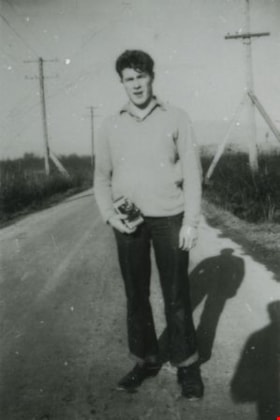
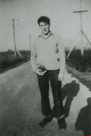
- Photograph of Hugh Pontifex with a camera in his hand, standing on Sperling Avenue near Sprott Street. The photograph was taken looking north.
- Repository
- City of Burnaby Archives
- Date
- January 1948 (date of original), copied 1991
- Collection/Fonds
- Burnaby Historical Society fonds
- Subseries
- Burnaby Image Bank subseries
- Physical Description
- 1 photograph : b&w ; 3.8 x 2.5 cm print on contact sheet 20.2 x 26.3 cm
- Description Level
- Item
- Record No.
- 370-503
- Access Restriction
- No restrictions
- Reproduction Restriction
- No known restrictions
- Accession Number
- BHS1999-03
- Scope and Content
- Photograph of Hugh Pontifex with a camera in his hand, standing on Sperling Avenue near Sprott Street. The photograph was taken looking north.
- Names
- Pontifex, Hugh
- Media Type
- Photograph
- Notes
- Title based on contents of photograph
- 1 b&w copy negative accompanying
- Negative has a pink cast
- Geographic Access
- Sperling Avenue
- Sprott Street
- Historic Neighbourhood
- Burnaby Lake (Historic Neighbourhood)
- Planning Study Area
- Burnaby Lake Area
Images
![Audrey Pontifex at Burnaby Lake, [between 1945 and 1949] (date of original), copied 1991 thumbnail](/media/hpo/_Data/_Archives_Images/_Unrestricted/370/370-504.jpg?width=280)
Audrey Pontifex at Burnaby Lake
https://search.heritageburnaby.ca/link/archivedescription37916
- Repository
- City of Burnaby Archives
- Date
- [between 1945 and 1949] (date of original), copied 1991
- Collection/Fonds
- Burnaby Historical Society fonds
- Description Level
- Item
- Physical Description
- 1 photograph : b&w ; 3.9 x 2.7 cm print on contact sheet 20.7 x 26.5 cm
- Scope and Content
- Photograph of Audrey Pontifex standing beside the water at Burnaby Lake.
- Repository
- City of Burnaby Archives
- Date
- [between 1945 and 1949] (date of original), copied 1991
- Collection/Fonds
- Burnaby Historical Society fonds
- Subseries
- Burnaby Image Bank subseries
- Physical Description
- 1 photograph : b&w ; 3.9 x 2.7 cm print on contact sheet 20.7 x 26.5 cm
- Description Level
- Item
- Record No.
- 370-504
- Access Restriction
- No restrictions
- Reproduction Restriction
- No restrictions
- Accession Number
- BHS1999-03
- Scope and Content
- Photograph of Audrey Pontifex standing beside the water at Burnaby Lake.
- Media Type
- Photograph
- Notes
- Title based on contents of photograph
- 1 b&w copy negative accompanying
- Negative has a pink cast
- Geographic Access
- Burnaby Lake
- Historic Neighbourhood
- Burnaby Lake (Historic Neighbourhood)
- Planning Study Area
- Burnaby Lake Area
Images
![Audrey Pontifex at Burnaby Lake, [between 1945 and 1949] (date of original), copied 1991 thumbnail](/media/hpo/_Data/_Archives_Images/_Unrestricted/370/370-504.jpg)
![Burnaby Lake Pavilion, [1972] thumbnail](/media/hpo/_Data/_Archives_Images/_Unrestricted/371/389-001.jpg?width=280)
Burnaby Lake Pavilion
https://search.heritageburnaby.ca/link/archivedescription38286
- Repository
- City of Burnaby Archives
- Date
- [1972]
- Collection/Fonds
- Burnaby Historical Society fonds
- Description Level
- Item
- Physical Description
- 1 photograph : sepia ; 8.7 x 13.3 cm
- Scope and Content
- Photograph of the Burnaby Lake Rowing Pavilion under construction. The pavilion and other facilities at Burnaby Lake were built in the early 1970s in preparation for the 1973 Canada Summer Games which were co-hosted in 1973 by Burnaby and New Westminster.
- Repository
- City of Burnaby Archives
- Date
- [1972]
- Collection/Fonds
- Burnaby Historical Society fonds
- Subseries
- Photographs subseries
- Physical Description
- 1 photograph : sepia ; 8.7 x 13.3 cm
- Description Level
- Item
- Record No.
- 389-001
- Access Restriction
- No restrictions
- Reproduction Restriction
- Reproduce for fair dealing purposes only
- Accession Number
- BHS2007-04
- Scope and Content
- Photograph of the Burnaby Lake Rowing Pavilion under construction. The pavilion and other facilities at Burnaby Lake were built in the early 1970s in preparation for the 1973 Canada Summer Games which were co-hosted in 1973 by Burnaby and New Westminster.
- Subjects
- Buildings - Recreational
- Media Type
- Photograph
- Notes
- Title based on contents of photograph.
- Geographic Access
- Burnaby Lake
- Roberts Street
- Street Address
- 6871 Roberts Street
- Historic Neighbourhood
- Burnaby Lake (Historic Neighbourhood)
- Planning Study Area
- Burnaby Lake Area
Images
![Burnaby Lake Pavilion, [1972] thumbnail](/media/hpo/_Data/_Archives_Images/_Unrestricted/371/389-001.jpg)

Burnaby Lake rowing course dredging
https://search.heritageburnaby.ca/link/archivedescription38303
- Repository
- City of Burnaby Archives
- Date
- 1971
- Collection/Fonds
- Burnaby Historical Society fonds
- Description Level
- Item
- Physical Description
- 1 photograph : col. ; 12.5 x 18 cm
- Scope and Content
- Aerial photograph of the Burnaby Lake rowing course being dredged in 1971, in preparation for the 1973 Canada Summer Games.
- Repository
- City of Burnaby Archives
- Date
- 1971
- Collection/Fonds
- Burnaby Historical Society fonds
- Subseries
- Photographs subseries
- Physical Description
- 1 photograph : col. ; 12.5 x 18 cm
- Description Level
- Item
- Record No.
- 400-001
- Access Restriction
- No restrictions
- Reproduction Restriction
- Reproduce for fair dealing purposes only
- Accession Number
- BHS2007-04
- Scope and Content
- Aerial photograph of the Burnaby Lake rowing course being dredged in 1971, in preparation for the 1973 Canada Summer Games.
- Media Type
- Photograph
- Notes
- Title based on contents of photograph
- Geographic Access
- Roberts Street
- Burnaby Lake
- Street Address
- 6871 Roberts Street
- Historic Neighbourhood
- Burnaby Lake (Historic Neighbourhood)
- Planning Study Area
- Burnaby Lake Area
Images

![Boathouse at Burnaby Lake, [1905] thumbnail](/media/hpo/_Data/_Archives_Images/_Unrestricted/477/477-126.jpg?width=280)
Boathouse at Burnaby Lake
https://search.heritageburnaby.ca/link/archivedescription38807
- Repository
- City of Burnaby Archives
- Date
- [1905]
- Collection/Fonds
- Peers Family and Hill Family fonds
- Description Level
- Item
- Physical Description
- 1 photograph : b&w ; 6.5 x 8.5 cm on page 11.5 x 14 cm (pasted in album)
- Scope and Content
- Photograph of the log boathouse at Burnaby Lake belonging to Bernard Hill.
- Repository
- City of Burnaby Archives
- Date
- [1905]
- Collection/Fonds
- Peers Family and Hill Family fonds
- Physical Description
- 1 photograph : b&w ; 6.5 x 8.5 cm on page 11.5 x 14 cm (pasted in album)
- Description Level
- Item
- Record No.
- 477-126
- Access Restriction
- No restrictions
- Reproduction Restriction
- No known restrictions
- Accession Number
- 2007-12
- Scope and Content
- Photograph of the log boathouse at Burnaby Lake belonging to Bernard Hill.
- Subjects
- Buildings - Residential - Boathouses
- Media Type
- Photograph
- Notes
- Title based on contents of photograph
- Geographic Access
- Burnaby Lake
- Historic Neighbourhood
- Burnaby Lake (Historic Neighbourhood)
- Planning Study Area
- Burnaby Lake Area
Images
![Boathouse at Burnaby Lake, [1905] thumbnail](/media/hpo/_Data/_Archives_Images/_Unrestricted/477/477-126.jpg)
![Boathouse at Burnaby Lake, [1905] thumbnail](/media/hpo/_Data/_Archives_Images/_Unrestricted/477/477-127.jpg?width=280)
Boathouse at Burnaby Lake
https://search.heritageburnaby.ca/link/archivedescription38808
- Repository
- City of Burnaby Archives
- Date
- [1905]
- Collection/Fonds
- Peers Family and Hill Family fonds
- Description Level
- Item
- Physical Description
- 1 photograph : b&w ; 6.5 x 8.5 cm on page 11.5 x 14 cm (pasted in album)
- Scope and Content
- Photograph of the log boathouse at Burnaby Lake belonging to Bernard Hill. In the background can be seen the "Maid of the Mist," the Hill family's boat.
- Repository
- City of Burnaby Archives
- Date
- [1905]
- Collection/Fonds
- Peers Family and Hill Family fonds
- Physical Description
- 1 photograph : b&w ; 6.5 x 8.5 cm on page 11.5 x 14 cm (pasted in album)
- Description Level
- Item
- Record No.
- 477-127
- Access Restriction
- No restrictions
- Reproduction Restriction
- No known restrictions
- Accession Number
- 2007-12
- Scope and Content
- Photograph of the log boathouse at Burnaby Lake belonging to Bernard Hill. In the background can be seen the "Maid of the Mist," the Hill family's boat.
- Subjects
- Buildings - Residential - Boathouses
- Media Type
- Photograph
- Notes
- Title based on contents of photograph
- Geographic Access
- Burnaby Lake
- Historic Neighbourhood
- Burnaby Lake (Historic Neighbourhood)
- Planning Study Area
- Burnaby Lake Area
Images
![Boathouse at Burnaby Lake, [1905] thumbnail](/media/hpo/_Data/_Archives_Images/_Unrestricted/477/477-127.jpg)
First Burnaby Lake tram through Burnaby Deer Lake station
https://search.heritageburnaby.ca/link/archivedescription38851
- Repository
- City of Burnaby Archives
- Date
- [1911]
- Collection/Fonds
- Peers Family and Hill Family fonds
- Description Level
- Item
- Physical Description
- 1 photograph : sepia ; 5.7 x 8 cm
- Scope and Content
- Photograph of the first Interurban tram going though the Deer Lake station in the Burnaby Lake area.
- Repository
- City of Burnaby Archives
- Date
- [1911]
- Collection/Fonds
- Peers Family and Hill Family fonds
- Physical Description
- 1 photograph : sepia ; 5.7 x 8 cm
- Description Level
- Item
- Record No.
- 477-170
- Access Restriction
- No restrictions
- Reproduction Restriction
- No known restrictions
- Accession Number
- 2007-12
- Scope and Content
- Photograph of the first Interurban tram going though the Deer Lake station in the Burnaby Lake area.
- Media Type
- Photograph
- Notes
- Title based on caption accompanying photograph
- Geographic Access
- Burnaby Lake Interurban line
- Historic Neighbourhood
- Burnaby Lake (Historic Neighbourhood)
- Planning Study Area
- Burnaby Lake Area
Images
Hill family and guests on Maid of the Mist
https://search.heritageburnaby.ca/link/archivedescription39422
- Repository
- City of Burnaby Archives
- Date
- 1905
- Collection/Fonds
- Peers Family and Hill Family fonds
- Description Level
- Item
- Physical Description
- 1 photograph : sepia ; 8.2 x 10.2 cm
- Scope and Content
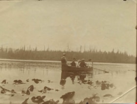
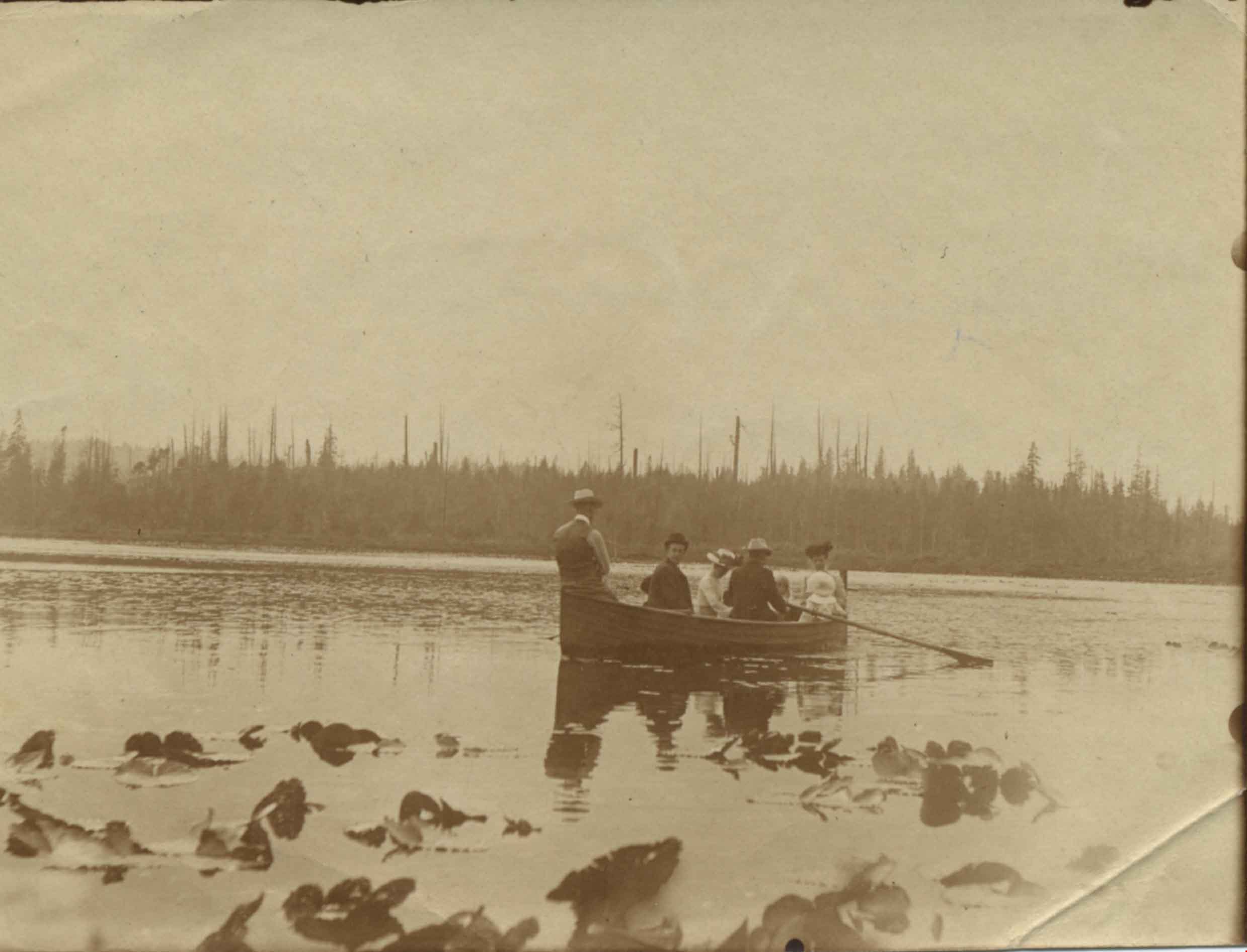
- Photrograph of the Hill Family and guests rowing in the "Maid of the Mist" on Burnaby Lake. Lily pads are visible in the foreground.
- Repository
- City of Burnaby Archives
- Date
- 1905
- Collection/Fonds
- Peers Family and Hill Family fonds
- Physical Description
- 1 photograph : sepia ; 8.2 x 10.2 cm
- Description Level
- Item
- Record No.
- 477-741
- Access Restriction
- No restrictions
- Reproduction Restriction
- No known restrictions
- Accession Number
- 2007-12
- Scope and Content
- Photrograph of the Hill Family and guests rowing in the "Maid of the Mist" on Burnaby Lake. Lily pads are visible in the foreground.
- Names
- Hill Family
- Media Type
- Photograph
- Notes
- Title based on caption accompanying photograph
- Geographic Access
- Burnaby Lake
- Historic Neighbourhood
- Burnaby Lake (Historic Neighbourhood)
- Planning Study Area
- Burnaby Lake Area
Images
![The Pole Line Road, [1915] thumbnail](/media/hpo/_Data/_Archives_Images/_Unrestricted/477/477-742.jpg?width=280)
The Pole Line Road
https://search.heritageburnaby.ca/link/archivedescription39423
- Repository
- City of Burnaby Archives
- Date
- [1915]
- Collection/Fonds
- Peers Family and Hill Family fonds
- Description Level
- Item
- Physical Description
- 1 photograph : b&w ; 8.8 x 8.8 cm
- Scope and Content
- Photograph taken looking north along the Pole Line road (now Sperling Avenue) towards the Burnaby Lake interurban station. Notice the planks along the road.
- Repository
- City of Burnaby Archives
- Date
- [1915]
- Collection/Fonds
- Peers Family and Hill Family fonds
- Physical Description
- 1 photograph : b&w ; 8.8 x 8.8 cm
- Description Level
- Item
- Record No.
- 477-742
- Access Restriction
- No restrictions
- Reproduction Restriction
- No known restrictions
- Accession Number
- 2007-12
- Scope and Content
- Photograph taken looking north along the Pole Line road (now Sperling Avenue) towards the Burnaby Lake interurban station. Notice the planks along the road.
- Subjects
- Geographic Features - Roads
- Media Type
- Photograph
- Notes
- Title based on caption accompanying photograph
- Geographic Access
- Sperling Avenue
- Historic Neighbourhood
- Burnaby Lake (Historic Neighbourhood)
- Planning Study Area
- Burnaby Lake Area
Images
![The Pole Line Road, [1915] thumbnail](/media/hpo/_Data/_Archives_Images/_Unrestricted/477/477-742.jpg)

Deer Lake
https://search.heritageburnaby.ca/link/archivedescription39434
- Repository
- City of Burnaby Archives
- Date
- 1900
- Collection/Fonds
- Peers Family and Hill Family fonds
- Description Level
- Item
- Physical Description
- 1 photograph : b&w ; 9.8 x 14 cm on mat 10.7 x 16.5 cm
- Scope and Content
- Photograph of an aboriginal dugout canoe on Deer Lake. The photograph was taken at the creek looking towards what would become the Oakalla Prison farm site.
- Repository
- City of Burnaby Archives
- Date
- 1900
- Collection/Fonds
- Peers Family and Hill Family fonds
- Physical Description
- 1 photograph : b&w ; 9.8 x 14 cm on mat 10.7 x 16.5 cm
- Description Level
- Item
- Record No.
- 477-753
- Access Restriction
- No restrictions
- Reproduction Restriction
- No known restrictions
- Accession Number
- 2007-12
- Scope and Content
- Photograph of an aboriginal dugout canoe on Deer Lake. The photograph was taken at the creek looking towards what would become the Oakalla Prison farm site.
- Media Type
- Photograph
- Notes
- Title based on caption accompanying photograph
- Geographic Access
- Deer Lake
- Historic Neighbourhood
- Burnaby Lake (Historic Neighbourhood)
- Planning Study Area
- Burnaby Lake Area
Images

![Boating on Burnaby Lake, [1900] thumbnail](/media/hpo/_Data/_Archives_Images/_Unrestricted/477/477-835.jpg?width=280)
Boating on Burnaby Lake
https://search.heritageburnaby.ca/link/archivedescription39516
- Repository
- City of Burnaby Archives
- Date
- [1900]
- Collection/Fonds
- Peers Family and Hill Family fonds
- Description Level
- Item
- Physical Description
- 1 photograph : b&w ; 7.5 x 10.5 cm on page 21.5 x 28 cm (pasted in album)
- Scope and Content
- Photograph of Annie Hill and her daughter, Kitty Hill, boating on Burnaby Lake.
- Repository
- City of Burnaby Archives
- Date
- [1900]
- Collection/Fonds
- Peers Family and Hill Family fonds
- Physical Description
- 1 photograph : b&w ; 7.5 x 10.5 cm on page 21.5 x 28 cm (pasted in album)
- Description Level
- Item
- Record No.
- 477-835
- Access Restriction
- No restrictions
- Reproduction Restriction
- No known restrictions
- Accession Number
- 2007-12
- Scope and Content
- Photograph of Annie Hill and her daughter, Kitty Hill, boating on Burnaby Lake.
- Subjects
- Recreational Activities - Boating
- Media Type
- Photograph
- Notes
- Title based on contents of photograph
- Historic Neighbourhood
- Burnaby Lake (Historic Neighbourhood)
- Planning Study Area
- Burnaby Lake Area
Images
![Boating on Burnaby Lake, [1900] thumbnail](/media/hpo/_Data/_Archives_Images/_Unrestricted/477/477-835.jpg)
![Burnaby Lake Pavilion, [1972] thumbnail](/media/hpo/_Data/_Archives_Images/_Unrestricted/371/389-002.jpg?width=280)
Burnaby Lake Pavilion
https://search.heritageburnaby.ca/link/archivedescription39789
- Repository
- City of Burnaby Archives
- Date
- [1972]
- Collection/Fonds
- Burnaby Historical Society fonds
- Description Level
- Item
- Physical Description
- 1 photograph : b&w ; 8.7 x 13.3 cm
- Scope and Content
- Photograph of the Burnaby Lake Rowing Pavilion. The pavilion and other facilities at Burnaby Lake were built in the early 1970s in preparation for the 1973 Canada Summer Games which were co-hosted in 1973 by Burnaby and New Westminster.
- Repository
- City of Burnaby Archives
- Date
- [1972]
- Collection/Fonds
- Burnaby Historical Society fonds
- Subseries
- Photographs subseries
- Physical Description
- 1 photograph : b&w ; 8.7 x 13.3 cm
- Description Level
- Item
- Record No.
- 389-002
- Access Restriction
- No restrictions
- Reproduction Restriction
- Reproduce for fair dealing purposes only
- Accession Number
- BHS2007-04
- Scope and Content
- Photograph of the Burnaby Lake Rowing Pavilion. The pavilion and other facilities at Burnaby Lake were built in the early 1970s in preparation for the 1973 Canada Summer Games which were co-hosted in 1973 by Burnaby and New Westminster.
- Media Type
- Photograph
- Notes
- Title based on contents of photograph.
- Geographic Access
- Burnaby Lake
- Roberts Street
- Street Address
- 6871 Roberts Street
- Historic Neighbourhood
- Burnaby Lake (Historic Neighbourhood)
- Planning Study Area
- Burnaby Lake Area
Images
![Burnaby Lake Pavilion, [1972] thumbnail](/media/hpo/_Data/_Archives_Images/_Unrestricted/371/389-002.jpg)
![Burnaby Lake Pavilion entrance, [1972] thumbnail](/media/hpo/_Data/_Archives_Images/_Unrestricted/371/389-003.jpg?width=280)
Burnaby Lake Pavilion entrance
https://search.heritageburnaby.ca/link/archivedescription39790
- Repository
- City of Burnaby Archives
- Date
- [1972]
- Collection/Fonds
- Burnaby Historical Society fonds
- Description Level
- Item
- Physical Description
- 1 photograph : b&w ; 8.7 x 13.3 cm
- Scope and Content
- Photograph of the entrance to the Burnaby Lake Rowing Pavilion. The pavilion and other facilities at Burnaby Lake were built in the early 1970s in preparation for the 1973 Canada Summer Games which were co-hosted in 1973 by Burnaby and New Westminster.
- Repository
- City of Burnaby Archives
- Date
- [1972]
- Collection/Fonds
- Burnaby Historical Society fonds
- Subseries
- Photographs subseries
- Physical Description
- 1 photograph : b&w ; 8.7 x 13.3 cm
- Description Level
- Item
- Record No.
- 389-003
- Access Restriction
- No restrictions
- Reproduction Restriction
- Reproduce for fair dealing purposes only
- Accession Number
- BHS2007-04
- Scope and Content
- Photograph of the entrance to the Burnaby Lake Rowing Pavilion. The pavilion and other facilities at Burnaby Lake were built in the early 1970s in preparation for the 1973 Canada Summer Games which were co-hosted in 1973 by Burnaby and New Westminster.
- Subjects
- Buildings - Recreational
- Media Type
- Photograph
- Notes
- Title based on contents of photograph.
- Geographic Access
- Burnaby Lake
- Roberts Street
- Street Address
- 6871 Roberts Street
- Historic Neighbourhood
- Burnaby Lake (Historic Neighbourhood)
- Planning Study Area
- Burnaby Lake Area
Images
![Burnaby Lake Pavilion entrance, [1972] thumbnail](/media/hpo/_Data/_Archives_Images/_Unrestricted/371/389-003.jpg)
![Burnaby Lake Pavilion, [1972] thumbnail](/media/hpo/_Data/_Archives_Images/_Unrestricted/371/389-004.jpg?width=280)
Burnaby Lake Pavilion
https://search.heritageburnaby.ca/link/archivedescription39791
- Repository
- City of Burnaby Archives
- Date
- [1972]
- Collection/Fonds
- Burnaby Historical Society fonds
- Description Level
- Item
- Physical Description
- 1 photograph : b&w ; 8.7 x 13.3 cm
- Scope and Content
- Photograph of two people carrying oars up a ramp at the Burnaby Lake Rowing Pavilion. The pavilion and other facilities at Burnaby Lake were built in the early 1970s in preparation for the 1973 Canada Summer Games which were co-hosted in 1973 by Burnaby and New Westminster.
- Repository
- City of Burnaby Archives
- Date
- [1972]
- Collection/Fonds
- Burnaby Historical Society fonds
- Subseries
- Photographs subseries
- Physical Description
- 1 photograph : b&w ; 8.7 x 13.3 cm
- Description Level
- Item
- Record No.
- 389-004
- Access Restriction
- No restrictions
- Reproduction Restriction
- Reproduce for fair dealing purposes only
- Accession Number
- BHS2007-04
- Scope and Content
- Photograph of two people carrying oars up a ramp at the Burnaby Lake Rowing Pavilion. The pavilion and other facilities at Burnaby Lake were built in the early 1970s in preparation for the 1973 Canada Summer Games which were co-hosted in 1973 by Burnaby and New Westminster.
- Subjects
- Buildings - Recreational
- Media Type
- Photograph
- Notes
- Title based on contents of photograph.
- Geographic Access
- Burnaby Lake
- Roberts Street
- Street Address
- 6871 Roberts Street
- Historic Neighbourhood
- Burnaby Lake (Historic Neighbourhood)
- Planning Study Area
- Burnaby Lake Area
Images
![Burnaby Lake Pavilion, [1972] thumbnail](/media/hpo/_Data/_Archives_Images/_Unrestricted/371/389-004.jpg)
![Burnaby Lake Pavilion, [1972] thumbnail](/media/hpo/_Data/_Archives_Images/_Unrestricted/371/389-005.jpg?width=280)
Burnaby Lake Pavilion
https://search.heritageburnaby.ca/link/archivedescription39792
- Repository
- City of Burnaby Archives
- Date
- [1972]
- Collection/Fonds
- Burnaby Historical Society fonds
- Description Level
- Item
- Physical Description
- 1 photograph : b&w ; 8.7 x 13.3 cm
- Scope and Content
- Photograph of an unidentified woman carrying an oar up a ramp at the Burnaby Lake Rowing Pavilion. The pavilion and other facilities at Burnaby Lake were built in the early 1970s in preparation for the 1973 Canada Summer Games which were co-hosted in 1973 by Burnaby and New Westminster.
- Repository
- City of Burnaby Archives
- Date
- [1972]
- Collection/Fonds
- Burnaby Historical Society fonds
- Subseries
- Photographs subseries
- Physical Description
- 1 photograph : b&w ; 8.7 x 13.3 cm
- Description Level
- Item
- Record No.
- 389-005
- Access Restriction
- No restrictions
- Reproduction Restriction
- Reproduce for fair dealing purposes only
- Accession Number
- BHS2007-04
- Scope and Content
- Photograph of an unidentified woman carrying an oar up a ramp at the Burnaby Lake Rowing Pavilion. The pavilion and other facilities at Burnaby Lake were built in the early 1970s in preparation for the 1973 Canada Summer Games which were co-hosted in 1973 by Burnaby and New Westminster.
- Subjects
- Buildings - Recreational
- Media Type
- Photograph
- Notes
- Title based on contents of photograph.
- Geographic Access
- Burnaby Lake
- Roberts Street
- Street Address
- 6871 Roberts Street
- Historic Neighbourhood
- Burnaby Lake (Historic Neighbourhood)
- Planning Study Area
- Burnaby Lake Area
Images
![Burnaby Lake Pavilion, [1972] thumbnail](/media/hpo/_Data/_Archives_Images/_Unrestricted/371/389-005.jpg)