Narrow Results By
Decade
- 2020s 224
- 2010s 149
- 2000s 1822
- 1990s 2868
- 1980s 1364
- 1970s 3511
- 1960s 1352
- 1950s
- 1940s 2010
- 1930s 2067
- 1920s 2345
- 1910s 1867
- 1900s 846
- 1890s
- 1880s 165
- 1870s 72
- 1860s 123
- 1850s 14
- 1840s 5
- 1830s 3
- 1820s 2
- 1810s 3
- 1800s 3
- 1790s 2
- 1780s 2
- 1770s 2
- 1760s 2
- 1750s 2
- 1740s 2
- 1730s 2
- 1720s 2
- 1710s 2
- 1700s 2
- 1690s 2
- 1680s 2
- 1670s 1
- 1660s 1
- 1650s 1
- 1640s 1
- 1630s 1
- 1620s 1
- 1610s 1
- 1600s 1
- 1590s 1
- 1580s 1
- 1570s 1
- 1560s 1
- 1550s 1
- 1540s 1
- 1530s 1
- 1520s 2
- 1510s 1
- 1500s 1
- 1490s 1
- 1480s 1
Subject
- Accidents - Automobile Accidents 2
- Adornment - Jewelry 4
- Advertising Medium 2
- Advertising Medium - Signs and Signboards 12
- Aerial Photographs 17
- Agricultural Tools and Equipment 4
- Agriculture - Crops 2
- Agriculture - Farms 35
- Agriculture - Fruit and Berries 8
- Agriculture - Poultry 1
- Animals 1
- Animals - Birds 10
Joseph & Jane Wintemute House
https://search.heritageburnaby.ca/link/landmark523
- Repository
- Burnaby Heritage Planning
- Description
- The Wintemute House is a large two-storey wood-frame Victorian era country farm house with Victorian Italianate detailing. Designed in a symmetrical Foursquare form, it features a low-pitched hipped roof with deep eaves. Later additions to the rear of the house, and the extensive wraparound veranda…
- Associated Dates
- 1891
- Formal Recognition
- Heritage Designation, Community Heritage Register
- Other Names
- Burnett House
- Street View URL
- Google Maps Street View
- Repository
- Burnaby Heritage Planning
- Other Names
- Burnett House
- Geographic Access
- Berkley Street
- Associated Dates
- 1891
- Formal Recognition
- Heritage Designation, Community Heritage Register
- Enactment Type
- Bylaw No. 6889
- Enactment Date
- 07/03/1977
- Description
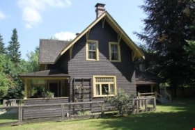
- The Wintemute House is a large two-storey wood-frame Victorian era country farm house with Victorian Italianate detailing. Designed in a symmetrical Foursquare form, it features a low-pitched hipped roof with deep eaves. Later additions to the rear of the house, and the extensive wraparound verandah and porte-cochere, were Edwardian era additions. It is located on its original site, in the modern subdivision of Buckingham Heights in southeast Burnaby. The Burnett House is one of the oldest surviving houses in Burnaby.
- Heritage Value
- Built circa 1891, the Joseph and Jane Wintemute House is valued as a representation of the early history of Burnaby and its agricultural origins. Built prior to the civic incorporation of Burnaby in 1892, the house was situated to face Douglas Road (now Canada Way), one of the first roads built to connect the rural farmlands of Burnaby to New Westminster. The original large property has been extensively subdivided and the house is now isolated in a modern subdivision. Designated in 1977, the Wintemute House is also significant as Burnaby's first protected municipal heritage site. The house is valued for its association with Joseph S. Wintemute (1832-1911) and Jane Wintemute (1832-1910), who came to British Columbia from Port Stanley, Ontario in 1865, traveling via the Isthmus of Panama. Joseph Wintemute, a skilled carpenter and contractor by trade, operated the Wintemute Furniture Factory in New Westminster, the first furniture plant established on the mainland of British Columbia. In 1891, he acquired this property, where he set up a cord wood sawmill to supply his factory. Wintemute was likely responsible for the design and construction of this commodious structure, as it was built in an Eastern Canadian style he would have been familiar with. After the lands were cleared of timber, the Wintemutes developed the property into a typical small-scale 'market garden,’ involved in the production of vegetables and fruits, such as strawberries, for sale at the New Westminster City Market. The Wintemute House is additionally significant for its association with the speculative land boom that occurred prior to the First World War, and ongoing suburban subdivision. Charles Gordon, a real estate agent, acquired the Wintemute farm and subdivided the acreage, which he marketed through the People’s Trust Company as 'Montrelynview' and offered this house as a draw prize to lot purchasers. With the collapse of the land boom, the house remained in Gordon’s possession until 1929 when it was purchased by his brother-in-law, Geoffrey Burnett, a local surveyor responsible for many of the original land surveys of Burnaby. David Burnett, Geoffrey's son, requested designation of the house when the family decided to subdivide the remaining 1.4 hectares of property in 1977. Furthermore, the Wintemute House is valued as an excellent example of a Victorian era country farm house, based loosely on the traditional farmhouses seen commonly in nineteenth century Ontario. Designed in a vernacular version of the Victorian Italianate style, the house displays restrained detailing, including several original multi-paned windows notable for their vertical proportions. The house retains many original exterior features, and the original interior layout, although modernized during the Edwardian era, is substantially intact, including finely crafted maple and cedar interior millwork that was produced by the Wintemute Furniture Factory. From 1904 to 1910, Charles Gordon, the second owner, made a number of alterations to the house including the addition of the wrap-around verandah, a porte-cochere and a 7.6 metre by 9 metre billiard room in the Arts and Crafts style, beamed and panelled in Douglas Fir. These later additions and alterations have value in demonstrating the evolution of the house and property and changing tastes at the turn of the nineteenth century.
- Defining Elements
- Key elements that define the heritage character of the Wintemute House include its: - picturesque original setting with views to the North Shore - residential form, scale and massing as expressed by its symmetrical cubic form and two-storey height, with later additions to the rear - Victorian Italianate architectural features such as the vertically-proportioned original windows with vestigial window hoods, low-pitched hipped roof and Classical Revival details such as the corner boards articulated as pilasters - hipped roof with deep boxed eaves - horizontal lapped narrow wooden siding - second storey balcony over front entry - wide wraparound columned verandah with porte-cochere, with square trimmed columns - irregular fenestration: original Victorian era double-hung 6-over-6 wood-sash windows with vertical proportions and segmental arched tops; Edwardian era double-hung 1-over-1 wooden-sash windows; and Edwardian era wooden-sash casement window assemblies with leaded transoms - central front entry with sidelights and transom - multi-paned French doors opening out to verandah - interior features such as its 3.7 metre ceiling height on the main and second floors; the coal grate fireplace with elaborate woodwork and glazed tile surround in the front parlour; five other fireplaces throughout the house; maple and cedar interior millwork; and the Douglas Fir panelled and beamed billiard room with hidden doors, seven-panelled doors, original light fixtures and mouldings - internal red brick chimneys with corbelled caps
- Historic Neighbourhood
- Burnaby Lake (Historic Neighbourhood)
- Planning Study Area
- Morley-Buckingham Area
- Function
- Primary Historic--Single Dwelling
- Primary Current--Single Dwelling
- Community
- Burnaby
- Cadastral Identifier
- 003-297-152
- Boundaries
- The Wintemute House is comprised of a single residential lot located at 7640 Berkley Street, Burnaby.
- Area
- 1566.73
- Contributing Resource
- Building
- Ownership
- Private
- Names
- Wintemute, Joseph
- Street Address
- 7640 Berkley Street
- Street View URL
- Google Maps Street View
Images
Charles R. Shaw House
https://search.heritageburnaby.ca/link/landmark525
- Repository
- Burnaby Heritage Planning
- Description
- The Charles R. Shaw House is a one and one-half storey plus basement wood-frame late Victorian era residence, located on the grounds of the Normanna Rest Home development in East Burnaby, near its original location on this site. Originally a modest vernacular Victorian structure, it has been enlarg…
- Associated Dates
- 1891
- Formal Recognition
- Heritage Designation, Community Heritage Register
- Other Names
- Charles R. & Mary Shaw House
- Street View URL
- Google Maps Street View
- Repository
- Burnaby Heritage Planning
- Other Names
- Charles R. & Mary Shaw House
- Geographic Access
- 12th Avenue
- 4th Street
- 13th Avenue
- Associated Dates
- 1891
- Formal Recognition
- Heritage Designation, Community Heritage Register
- Enactment Type
- Bylaw No. 10739
- Enactment Date
- 06/04/1998
- Description
- The Charles R. Shaw House is a one and one-half storey plus basement wood-frame late Victorian era residence, located on the grounds of the Normanna Rest Home development in East Burnaby, near its original location on this site. Originally a modest vernacular Victorian structure, it has been enlarged and embellished through later additions.
- Heritage Value
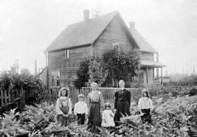
- The Shaw House is one of the oldest surviving houses in Burnaby, and is valued as a representation of a typical vernacular pioneer house in Burnaby, and a rare survivor from the late Victorian era. The original portion of the house displays a simplicity of form and detail consistent with early local construction, while the later additions display a more sophisticated approach. Originally built in 1891, this house is valued for its association with first owner, Charles R. Shaw (1834-1916) and Mary D. Shaw (1848-1897), one of Burnaby’s earliest settlers. Born in England, Shaw immigrated to Toronto in 1869, and relocated to New Westminster in 1889, where he worked as an employee of the Mechanic's Mill Company, an early woodworking plant. After moving to Burnaby, he was unanimously elected by acclamation as first reeve (mayor) of the new municipality in 1892. In 1894, Shaw sold his house and farm and moved his family to Kamloops due to his wife Mary's failing health. After Mary died in 1897, the Shaw family returned to Toronto. The Shaw House is additionally valued for its association with a later owner, James Brookes (1884-1953), founder of James Brookes Woodworking Ltd., a mill that was a major employer in East Burnaby. Brookes bought and renovated the house in 1917. In 1927, he built a much larger house on the property (now demolished), and the original house was moved to the corner of the property to serve as a gardener's cottage for Brookes' estate. The additions made to the house at this time employed sash and milled products produced by the Brookes plant. Although altered, this Victorian era residence remains largely intact, with Brookes’s later additions.
- Defining Elements
- Key elements that define the heritage character of the Shaw House include its: - modest vernacular residential form, scale and massing, as exemplified by its one and one-half storey plus basement height, front gabled roof, shed roofed verandah and asymmetrical plan - asymmetrical front entrance - cladding: horizontal wooden drop siding on the original portion of the house; cedar shingles on additions; decorative octagonal cedar shingles in the front gable; original decorated bargeboards at front, with cut-out details - later renovations to the front verandah and side addition which resulted in a partially glazed porch entrance and addition with large window assemblies - square verandah columns - irregular fenestration: double-hung wooden-sash windows in a variety of configurations such as 6-over-1 and 4-over-1 windows in the original portion of the house, 12-over-1 windows, and one 24-over-1 window in the front addition - small window at front entry - fifteen-pane French front entry door - internal red brick chimney with corbelled cap
- Historic Neighbourhood
- East Burnaby (Historic Neighbourhood)
- Planning Study Area
- Edmonds Area
- Function
- Primary Historic--Single Dwelling
- Primary Current--Single Dwelling
- Community
- Burnaby
- Cadastral Identifier
- 003-253-848
- Boundaries
- The Shaw House is comprised of a single residential lot located at 7725 Fourth Street (legal address), Burnaby
- Area
- 9199.27
- Contributing Resource
- Building
- Ownership
- Private
- Names
- Shaw, Charles R
- Street Address
- 7725 4th Street
- Street View URL
- Google Maps Street View
Images
Jesse Love House
https://search.heritageburnaby.ca/link/landmark540
- Repository
- Burnaby Heritage Planning
- Description
- The Jesse Love House is a vernacular example of a late Victorian-era wood-frame farmhouse with later Arts and Crafts alterations and additions, that has been relocated to the Burnaby Village Museum. This two-storey house has an L-shaped plan, with a compound gabled roof, overhanging eaves and a lar…
- Associated Dates
- 1893
- Formal Recognition
- Heritage Designation, Community Heritage Register
- Other Names
- Jesse & Martha Love Farmhouse
- Street View URL
- Google Maps Street View
- Repository
- Burnaby Heritage Planning
- Other Names
- Jesse & Martha Love Farmhouse
- Geographic Access
- Deer Lake Avenue
- Associated Dates
- 1893
- Formal Recognition
- Heritage Designation, Community Heritage Register
- Enactment Type
- Bylaw No. 9807
- Enactment Date
- 23/11/1992
- Description
- The Jesse Love House is a vernacular example of a late Victorian-era wood-frame farmhouse with later Arts and Crafts alterations and additions, that has been relocated to the Burnaby Village Museum. This two-storey house has an L-shaped plan, with a compound gabled roof, overhanging eaves and a large wraparound verandah.
- Heritage Value
- The value of the Jesse Love House lies in its comprehensive representation of an early Burnaby farmhouse, and the typical additive growth of a home as the resident family prospered. Jesse Love (1849-1928) and his wife Martha Love (1858-1920) moved to Burnaby in 1893 with their family to start a fruit ranch and market garden on Cumberland Road in the East Burnaby district. Jesse Love was actively involved in community affairs, serving on the Burnaby School Board and also as a District Councillor in 1901 and from 1904-07. The original house was constructed by local builder George Salt and consisted of an entrance hall, dining room, lean-to kitchen, master bedroom and several rooms upstairs. As the family grew and prospered, additions were made to the house including a parlour, more bedrooms upstairs, and a large permanent kitchen. Jesse Love was actively involved in community affairs, and the kitchen became a local gathering spot for political discussion and civic organizations. The verandah, exterior shingle cladding, large windows, running water and electricity were eventually added as well. The heritage value for this house also lies in its interpretive value within the Burnaby Village Museum. The site is an important cultural feature for the interpretation of Burnaby’s heritage to the public. The house was moved to the Burnaby Village Museum in 1988 and both the interior and exterior were restored and interpreted to their 1925 period, including reproduction wallpaper.
- Defining Elements
- The character defining features of the Jesse Love House include its: - irregular form and massing - compound gable roof with cedar shingle cladding - Craftsman-style exterior features such as a shingled exterior and triangular eave brackets - multi-paned double-hung 2-over-2 wooden-sash windows; casement window assemblies with transoms in the Living Room - large wrap-around verandah - interior features such as pressed tin ceilings, original wallpapers and cedar panelled kitchen - reproduction Arts and Crafts parlour document wallpaper and border
- Locality
- Deer Lake Park
- Historic Neighbourhood
- Burnaby Lake (Historic Neighbourhood)
- Planning Study Area
- Morley-Buckingham Area
- Organization
- Burnaby Village Museum
- Builder
- George Salt
- Function
- Primary Current--Museum
- Primary Historic--Single Dwelling
- Community
- Burnaby
- Cadastral Identifier
- P.I.D. No. 011-030-356 Legal Description: Parcel 1, District Lot 79 and District Lot 85, Group 1, New Westminster District, Reference Plan 77594
- Boundaries
- Burnaby Village Museum is comprised of a single municipally-owned property located at 6501 Deer Lake Avenue, Burnaby.
- Area
- 38,488.63
- Contributing Resource
- Building
- Landscape Feature
- Structure
- Ownership
- Public (local)
- Documentation
- Heritage Site Files: PC77000 20. City of Burnaby Planning and Building Department, 4949 Canada Way, Burnaby, B.C., V5G 1M2
- Street Address
- 6501 Deer Lake Avenue
- Street View URL
- Google Maps Street View
Images
North Burnaby Cenotaph
https://search.heritageburnaby.ca/link/landmark550
- Repository
- Burnaby Heritage Planning
- Description
- The North Burnaby Cenotaph is located in Confederation Park at the north end of the park on axis with the adjacent sports oval. The form of the memorial is of an obelisk atop a solid rectangular base, adorned with plaques commemorating those lost in the First World War, Second World War and the Kor…
- Associated Dates
- 1953
- Formal Recognition
- Heritage Designation, Community Heritage Register
- Repository
- Burnaby Heritage Planning
- Geographic Access
- Willingdon Avenue
- Associated Dates
- 1953
- Formal Recognition
- Heritage Designation, Community Heritage Register
- Enactment Type
- Bylaw No. 9807
- Enactment Date
- 23/11/1992
- Description
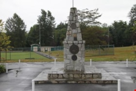
- The North Burnaby Cenotaph is located in Confederation Park at the north end of the park on axis with the adjacent sports oval. The form of the memorial is of an obelisk atop a solid rectangular base, adorned with plaques commemorating those lost in the First World War, Second World War and the Korean War.
- Heritage Value
- Built in 1953 by stonemason and First World War Veteran, Walter Holmes Morrice, the cenotaph was erected by the North Burnaby Legion Post #148 and is one of four memorials to citizens of Burnaby whose lives were lost at war. Strategically placed in an active and vibrant public park that was dedicated in 1927 and is used for sports, family outings and social gatherings, the cenotaph celebrates the freedoms that soldiers gave their lives to protect. The cenotaph is still used as a memorial site and bears witness to annual Remembrance Day ceremonies. Built of irregular granite blocks, the cenotaph is a solid structure of modest ornamentation that visually anchors the north end of the park. The site of the cenotaph and its adjacent gardens are surrounded by a simple barrier of continuous chain supported by low metal fence posts, providing a sense of solemnity and ceremony to the site.
- Defining Elements
- The character-defining elements of the North Burnaby Cenotaph include its: - axial location in the park and setting among active municipal facilities such as a school and library - strong symmetry of massing and design - obelisk form set atop a rectangular base - limited palette of materials - random coursed granite used as primary building material - bronze plaques commemorating the First and Second World Wars and the Korean War - surrounding pathways and flowerbeds
- Historic Neighbourhood
- Capitol Hill (Historic Neighbourhood)
- Planning Study Area
- Capitol Hill Area
- Organization
- North Burnaby Legion Post #148
- Builder
- Walter Holmes Morrice
- Function
- Primary Current--Park Fixture
- Primary Historic--Park Fixture
- Community
- Burnaby
- Cadastral Identifier
- P.I.D. No. 017-040-752 Legal Description: Parcel 1, District Lots 122 and 188, Group 1, New Westminster District, Plan NWP87902
- Boundaries
- The property (Confederation Park) is comprised of a single municipally-owned property located at 250 Willingdon Avenue, Burnaby.
- Area
- 184,160.00
- Contributing Resource
- Landscape Feature
- Structure
- Ownership
- Public (local)
- Documentation
- Heritage Site Files: PC77000 20. City of Burnaby Planning and Building Department, 4949 Canada Way, Burnaby, B.C., V5G 1M2
- Street Address
- 250 Willingdon Avenue
Images
Helen 'The Swinging Girl' Neon Sign
https://search.heritageburnaby.ca/link/landmark591
- Repository
- Burnaby Heritage Planning
- Description
- Commercial building.
- Associated Dates
- 1956
- Formal Recognition
- Heritage Designation, Community Heritage Register
- Other Names
- Helen's Childrens Wear Sign
- Street View URL
- Google Maps Street View
- Repository
- Burnaby Heritage Planning
- Other Names
- Helen's Childrens Wear Sign
- Geographic Access
- Hastings Street
- Associated Dates
- 1956
- Formal Recognition
- Heritage Designation, Community Heritage Register
- Enactment Type
- Bylaw No. 12771
- Enactment Date
- 19/04/2010
- Description
- Commercial building.
- Heritage Value
- While the building here is of some importance as the former North Burnaby municipal office, its primary importance is its delightful neon sign that has become a North Burnaby landmark. Helen Arnold opened Helen’s Childrens Wear shop in the building next door to the old Municipal offices in 1948. In 1955, when North Burnaby moved out, she moved into the vacated building. As part of the renovations, Helen enlisted the assistance of her good friend Jimmy Wallace, owner of Vancouver’s Wallace Neon Company, to create a new sign for her expanded business. One of the company’s designers, Reeve Lehman, created the swinging neon girl that was installed in 1956. Designed in two parts, one section of the sign is cloud shaped and reads ‘Helen’s’ while the other section is a moving representation of a little girl on a swing. The sign is nine feet six inches high and nine feet wide, and the lower section is animated with an internal motor and gears. It immediately became a landmark on Hastings Street, and recently the sign’s design fame has spread far and wide as one of the best surviving examples of kinetic neon art in North America.
- Locality
- Vancouver Heights
- Historic Neighbourhood
- Vancouver Heights (Historic Neighbourhood)
- Planning Study Area
- Willingdon Heights Area
- Community
- Burnaby
- Names
- Helen's Childrens Wear
- Street Address
- 4142 Hastings Street
- Street View URL
- Google Maps Street View
Images
Willingdon Heights United Church
https://search.heritageburnaby.ca/link/landmark658
- Repository
- Burnaby Heritage Planning
- Description
- Church building.
- Associated Dates
- 1951
- Street View URL
- Google Maps Street View
- Repository
- Burnaby Heritage Planning
- Geographic Access
- Parker Street
- Associated Dates
- 1951
- Description
- Church building.
- Heritage Value
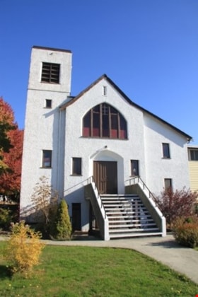
- This church was built to serve a 500-home subdivision known as Willingdon Heights–Canada’s largest single veteran’s housing project created by the Central Mortgage and Housing Corporation and constructed by the Whitsell Construction Company in 1948. The church building was designed as a simplified Gothic Revival church with a tall front tower and Gothic pointed-arch stained glass window and entrance. This church was designed by Vancouver architects Twizell & Twizell. Both Robert Twizell (1875-1964) and younger brother George Twizell (1885-1957) articled at Newcastle, England’s Hicks & Charlewood before arriving in Vancouver in late 1907 or early 1908, with George working for Robert until they established a partnership a few years later. Their firm lasted for nearly half a century and was well known for its numerous church designs.
- Locality
- Vancouver Heights
- Historic Neighbourhood
- Vancouver Heights (Historic Neighbourhood)
- Planning Study Area
- Willingdon Heights Area
- Architect
- Twizell & Twizell
- Area
- 1808.82
- Contributing Resource
- Building
- Ownership
- Private
- Street Address
- 4304 Parker Street
- Street View URL
- Google Maps Street View
Images
Vancouver Heights Neighbourhood
https://search.heritageburnaby.ca/link/landmark666
- Repository
- Burnaby Heritage Planning
- Associated Dates
- 1925-1954
- Heritage Value
- Vancouver Heights remained an important residential and commercial centre in Burnaby throughout the 1925-1954 period. The area had its own Board of Trade and the North Burnaby Library was created to serve the residents. In 1949, the Hastings streetcars stopped running, but the area retained its reputation as one of the best shopping districts in the city.
- Historic Neighbourhood
- Vancouver Heights (Historic Neighbourhood)
- Planning Study Area
- Burnaby Heights Area
Images
Capitol Hill Neighbourhood
https://search.heritageburnaby.ca/link/landmark667
- Repository
- Burnaby Heritage Planning
- Associated Dates
- 1925-1954
- Heritage Value
- Although the Hastings street-car extension to Ellesmere opened in 1913 and there had been much speculation in the area during the real estate boom of 1909-1913, development in Capitol Hill did not really take off until after World War One when workers in Vancouver started to look to Burnaby for affordable but centrally-located neighbourhoods in which to build their homes. The 1913 one-room school had to be replaced in 1923 and in 1948, members of the community came together to build a new Community Hall.
- Historic Neighbourhood
- Capitol Hill (Historic Neighbourhood)
- Planning Study Area
- Capitol Hill Area
Images
Lochdale Neighbourhood
https://search.heritageburnaby.ca/link/landmark668
- Repository
- Burnaby Heritage Planning
- Associated Dates
- 1925-1954
- Heritage Value
- In the 1931 "Burnaby Year Book" the Lochdale neighbourhood is described as follows: "Lochdale…is situated at the intersection of the Hastings-Barnet road at the point where Sperling Avenue crosses…Situated at the intersection…there are an up to date service station and a general store, at which the Lochdale Post Office is situated. Immediately north of this is the seventy acres on which the Shell Oil Co. are to build an up-to-date refinery...On going south on Sperling Avenue can be found some lovely homes of the residents, all of which possess the most beautiful flower gardens, some of which are hobbies, and some being in the nature of a business. Others are engaged in chicken farming...while others find employment at the Barnet Mill about two miles east on the Hastings-Barnet Road."
- Historic Neighbourhood
- Lochdale (Historic Neighbourhood)
- Planning Study Area
- Lochdale Area
Images
Brentwood Neighbourhood
https://search.heritageburnaby.ca/link/landmark669
- Repository
- Burnaby Heritage Planning
- Associated Dates
- 1925-1954
- Heritage Value
- In July, 1953, Burnaby's Municipal Council gave approval for the construction of a $12,000,000 residential and shopping development to be called Brentwood Park, located on the northeast corner of Lougheed and Willingdon. Plans called for about 400 homes and a 30-acre shopping centre to be built in this new subdivision - the first large residential subdivision in Burnaby to be developed with sewers and paved streets as well as other services.
- Planning Study Area
- Brentwood Area
Images
Willingdon Heights Neighbourhood
https://search.heritageburnaby.ca/link/landmark670
- Repository
- Burnaby Heritage Planning
- Associated Dates
- 1925-1954
- Heritage Value
- Willingdon Heights was another new subdivision developed in Burnaby during the post-World War Two building boom. A brochure about the development published in 1948 proclaimed "the Willingdon Heights 500 home development project in Burnaby fulfills its promise to provide a self-contained community for former members of the armed services and their families...the largest single veteran housing project in Canada as far as homes for individual ownership is concerned, Willingdon Heights development was planned by the Central Mortgage and Housing Corporation...At this date the earlier built rows of homes have passable roads and the owners are improving lawns and gardens in spare time...eventually additional stores and professional services will be installed and recreational projects will add to the amenities of a community of congenial residents..."
- Planning Study Area
- Willingdon Heights Area
Images
Parkcrest Neighbourhood
https://search.heritageburnaby.ca/link/landmark671
- Repository
- Burnaby Heritage Planning
- Associated Dates
- 1925-1954
- Heritage Value
- On May 10, 1951, the Burnaby News-Courier reported on the new Parkcrest subdivision, saying: "Central Burnaby is the scenic locale of a successful attempt to produce modern houses economically and yet avoid the mass production effect common to other housing developments. That is one of the many highlights peculiar to the new Parkcrest development of 275 homes...By giving home purchasers a wide choice of finishes, extras and colours, hundreds of variations are possible on the six basic floor plans...Travelling time by car to Hastings and Granville from Parkcrest has been clocked at 15 minutes...Both primary and junior high schools are within walking distance. A modern shopping centre is planned for the future...Several streets are laid out in a straight but irregular manner, thus eliminating the prosaic side by side appearance block by block, as in other housing developments."
- Planning Study Area
- Parkcrest-Aubrey Area
Images
Crabtown
https://search.heritageburnaby.ca/link/landmark674
- Repository
- Burnaby Heritage Planning
- Associated Dates
- 1912-1957
- Heritage Value
- North Burnaby's waterfront was the location of a unique squatter's community known as Crabtown. Although its origins are obscure, it is believed that the first shacks were built before 1912. When the depression of 1913-1917 began, the shacks became permanent homes for impoverished workers. During the Great Depression of the 1930s, the community grew larger. Crabtown was not a slum, but a neighbourhood - the community even rallied together to build a water supply system and trails up the steep bluff with steps and banisters so children could go to school safely. In 1957, the National Harbours Board decided that Crabtown was encroaching on Federal property and evicted all 130 residents. Within a few months, residents were relocated and 114 homes were levelled.
- Historic Neighbourhood
- Vancouver Heights (Historic Neighbourhood)
- Planning Study Area
- Burnaby Heights Area
Images
Shell Oil Company
https://search.heritageburnaby.ca/link/landmark675
- Repository
- Burnaby Heritage Planning
- Geographic Access
- Kensington Avenue
- Associated Dates
- ca. 1930-1993
- Heritage Value
- After considering several sites in the Greater Vancouver area, the Shell Oil Company chose 70 acres in North Burnaby with frontage of one third of a mile on Burrard Inlet. Shell proposed to build a four-million dollar plant that would employ up to 2000 - providing some relief in the middle of Burnaby's economic crisis of the Depression years. The site became known as the Shellburn Refinery and was in operation until 1993.
- Historic Neighbourhood
- Lochdale (Historic Neighbourhood)
- Planning Study Area
- Westridge Area
Images
Westridge School
https://search.heritageburnaby.ca/link/landmark676
- Repository
- Burnaby Heritage Planning
- Geographic Access
- Duncan Avenue
- Associated Dates
- 1953
- Heritage Value
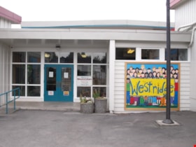
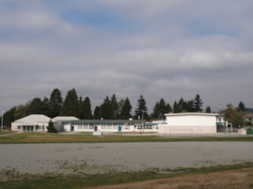
- The building boom in Burnaby during the first few years of the 1950s resulted in many new subdivisions being created in previously unoccupied areas of Burnaby. One such neighbourhood was the Westridge area. In 1951, the Inspector of Schools noted in a report that there were 475 new homes in Westridge with another 100 under development. As a result, enrolment pressures were particularly heavy in this area and the School Board opened the Westridge Elementary School in 1953.
- Historic Neighbourhood
- Lochdale (Historic Neighbourhood)
- Planning Study Area
- Westridge Area
- Street Address
- 510 Duncan Avenue
- Street View URL
- Google Maps Street View
Images
Lochdale School
https://search.heritageburnaby.ca/link/landmark677
- Repository
- Burnaby Heritage Planning
- Geographic Access
- Aubrey Street
- Associated Dates
- 1953
- Heritage Value
- Lochdale Community School was opened in 1953 to help alleviate the increased enrolment at Sperling Elementary School caused by the new subdivisions under construction in this section of Burnaby. Lochdale was typical of the schools built at the period with classrooms constructed in a line, as close as possible to ground level. As needed, new classrooms were extended in a line and there were additions to Lochdale in 1962, 1964, 1966, 1971 and 1976.
- Historic Neighbourhood
- Lochdale (Historic Neighbourhood)
- Planning Study Area
- Lochdale Area
- Street Address
- 6990 Aubrey Street
- Street View URL
- Google Maps Street View
Images
Alpha Secondary School
https://search.heritageburnaby.ca/link/landmark678
- Repository
- Burnaby Heritage Planning
- Geographic Access
- Parker Street
- Associated Dates
- 1950
- Heritage Value
- The unexpected period of growth in Burnaby during the first few years of the 1950s resulted in many overcrowded schools. As a result, the School Board decided it required a Junior High to alleviate enrolment issues at Gilmore Avenue Elementary-Junior school. Alpha opened in 1950 with 423 students. The new school had 12 rooms but added more in 1953. There were fires at the school in 1956 and 1964, resulting in the rebuilding of seven classrooms, library and administrative offices. There were additions made in 1968 and 1969 and in 1976 a gymnasium was built.
- Planning Study Area
- Brentwood Area
- Street Address
- 4600 Parker Street
- Street View URL
- Google Maps Street View
Images
Brentwood Park Elementary School
https://search.heritageburnaby.ca/link/landmark679
- Repository
- Burnaby Heritage Planning
- Geographic Access
- Delta Avenue
- Associated Dates
- 1954
- Heritage Value
- Brentwood Park Elementary School was built during the post-World War Two housing boom in Burnaby and like other schools at the time, was similar in design - no basements, no second stories and no high stairways. New classrooms could be added in line with the original structure as was the case when two additions were put on between 1956 and 1958, a new classroom and library added in 1965-1966 and two more classrooms in 1969.
- Planning Study Area
- Brentwood Area
- Street Address
- 1455 Delta Avenue
- Street View URL
- Google Maps Street View
Images
Westridge Neighbourhood
https://search.heritageburnaby.ca/link/landmark680
- Repository
- Burnaby Heritage Planning
- Associated Dates
- 1925-1954
- Heritage Value
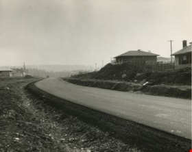
- The Westridge Neighbourhood of Burnaby was created as a new subdivision during the post-World War Two housing boom in Burnaby. Developed by the C.B. Riley Company, it was laid out in a plan contoured to the shapes of the land and was situated to allow residents easy access to main transportation routes.
- Historic Neighbourhood
- Lochdale (Historic Neighbourhood)
- Planning Study Area
- Westridge Area
Images
Barnet Neighbourhood
https://search.heritageburnaby.ca/link/landmark681
- Repository
- Burnaby Heritage Planning
- Associated Dates
- 1925-1954
- Heritage Value
- In 1925, the mill at Barnet was under new ownership and was known as the Barnet Lumber Company. It was one of the most successful local employers in Burnaby until the 1930s, when the economic crisis of the Great Depression resulted in a strike at the mill. The City of Burnaby eventually assumed control of the site - including all of the homes - when the company failed to pay its taxes. The City then dismantled the mill and resold the property in two parts - the eastern section would become the Kapoor sawmill and the western portion, the McColl-Frontenac Oil Company.
- Historic Neighbourhood
- Barnet (Historic Neighbourhood)
- Planning Study Area
- Burnaby Mountain Area


