Narrow Results By
Decade
- 2020s 225
- 2010s 157
- 2000s 1824
- 1990s 2875
- 1980s 1366
- 1970s 3516
- 1960s 1357
- 1950s 1715
- 1940s
- 1930s
- 1920s 2530
- 1910s 2124
- 1900s 878
- 1890s 250
- 1880s 165
- 1870s 72
- 1860s 123
- 1850s 14
- 1840s 5
- 1830s 3
- 1820s 2
- 1810s 3
- 1800s 3
- 1790s 2
- 1780s 2
- 1770s 2
- 1760s 2
- 1750s 2
- 1740s 2
- 1730s 2
- 1720s 2
- 1710s 2
- 1700s 2
- 1690s 2
- 1680s 2
- 1670s 1
- 1660s 1
- 1650s 1
- 1640s 1
- 1630s 1
- 1620s 1
- 1610s 1
- 1600s 1
- 1590s 1
- 1580s 1
- 1570s 1
- 1560s 1
- 1550s 1
- 1540s 1
- 1530s 1
- 1520s 2
- 1510s 1
- 1500s 1
- 1490s 1
- 1480s 1
Subject
- Accidents 6
- Accidents - Automobile Accidents 9
- Accidents - Train Accidents 14
- Advertising Medium 1
- Advertising Medium - Signs and Signboards 26
- Aerial Photographs 9
- Agricultural Tools and Equipment 6
- Agricultural Tools and Equipment - Cultivators 2
- Agricultural Tools and Equipment - Gardening Equipment 4
- Agricultural Tools and Equipment - Plows 2
- Agricultural Tools and Equipment - Tractors 1
- Agriculture 7

Central Park Neighbourhood
https://search.heritageburnaby.ca/link/landmark688
- Repository
- Burnaby Heritage Planning
- Associated Dates
- 1925-1954
- Heritage Value
- Although still largely a rural area during the 1920s, subdivisions began appearing in the Central Park neighbourhood at this time. Development was slowed by the Great Depression of the 1930s but the influx of commercial buildings and new housing initiatives in the post-war boom led to a period of rapid growth especially in the Garden Village subdivision which was undertaken in 1953 with the plan to build 500 modern homes in the 140-acre site. Despite the closure of the interurban line in 1953, the neighbourhood remained an active commercial and residential centre.
- Historic Neighbourhood
- Central Park (Historic Neighbourhood)
- Planning Study Area
- Maywood Area
Images


Burnaby Lake Neighbourhood
https://search.heritageburnaby.ca/link/landmark700
- Repository
- Burnaby Heritage Planning
- Associated Dates
- 1925-1954
- Heritage Value
- After World War I and the Great Depression of the 1930s, more homes were constructed and subdivisions created in the Burnaby Lake district. The area around Deer Lake gained a reputation for being an "artistic development of commodious homes with park-like grounds."
- Historic Neighbourhood
- Burnaby Lake (Historic Neighbourhood)
- Planning Study Area
- Burnaby Lake Area
Images


Lozells Neighbourhood
https://search.heritageburnaby.ca/link/landmark701
- Repository
- Burnaby Heritage Planning
- Associated Dates
- 1925-1954
- Heritage Value
- Like a lot of residential neighbourhoods in Burnaby during the post-War boom, the Lozells area during the 1925-1954 period was one of new construction and subdivisions. Although more homes were being built, the neighbourhood still retained a somewhat rural characteristic well into the 1950s.
- Historic Neighbourhood
- Lozells (Historic Neighbourhood)
- Planning Study Area
- Government Road Area
Images


Lake City Neighbourhood
https://search.heritageburnaby.ca/link/landmark702
- Repository
- Burnaby Heritage Planning
- Associated Dates
- 1925-1954
- Heritage Value
- When the Lake City Industrial Park first opened in the 1950's, it was a fairly isolated industrial enclave with convenient access to rail and road transportation routes. The sense of entrepreneurial flare and success that was anticipated for the area is evident in the naming of local streets which include "Production", "Enterprise" and "Venture". The anticipated potential of the area was also demonstrated by the inclusion of many significant development amenities of the time, such as paved streets, site landscaping, rail service, natural gas service, and architectural controls.
- Planning Study Area
- Lake City Area
Images


Burquitlam Neighbourhood
https://search.heritageburnaby.ca/link/landmark703
- Repository
- Burnaby Heritage Planning
- Associated Dates
- 1925-1954
- Heritage Value
- By the 1950s, the Burquitlam Neighbourhood was becoming a residential and commercial centre for the northeast section of Burnaby. The Sullivan Heights area was developed as a single-family residential area with the Lyndhurst School opening in 1954. The completion of the Lougheed Highway in 1953 encouraged more commercial and retail development and fostered the growth of the neighbourhood throughout this period.
- Historic Neighbourhood
- Burquitlam (Historic Neighbourhood)
- Planning Study Area
- Lyndhurst Area
Images


Edmonds Neighbourhood
https://search.heritageburnaby.ca/link/landmark704
- Repository
- Burnaby Heritage Planning
- Associated Dates
- 1925-1954
- Heritage Value
- The historic growth of Edmonds as a neighbourhood was based on its strategic location on the early interurban line between Vancouver and New Westminster. Even by 1980 when a survey of the residential neighbourhoods was conducted, a full 25% of homes in the area predated 1930. The 1950s was a period of strong housing development, with both single-family and multi-family units being constructed. Although Burnaby's City Hall was moved from Kingsway and Edmonds in the early 1950s, Edmonds remained an important centre in the community.
- Historic Neighbourhood
- Edmonds (Historic Neighbourhood)
- Planning Study Area
- Stride Avenue Area
Images


Alta Vista Neighbourhood
https://search.heritageburnaby.ca/link/landmark707
- Repository
- Burnaby Heritage Planning
- Associated Dates
- 1925-1954
- Heritage Value
- As with many areas of Burnaby during this period, the years after World War Two marked a rapid growth in residential development in the Alta-Vista Neighbourhood. Subdivisions like Sussex and Suncrest were built and new schools and amenities were constructed to meet the demands of increased population.
- Historic Neighbourhood
- Alta Vista (Historic Neighbourhood)
- Planning Study Area
- Sussex-Nelson Area
Images


Fraser Arm Neighbourhood
https://search.heritageburnaby.ca/link/landmark708
- Repository
- Burnaby Heritage Planning
- Associated Dates
- 1925-1954
- Heritage Value
- By the late 1920s, the Fraser Arm Neighbourhood in Burnaby was developing into an industrial and manufacturing district. In 1931, the Canadian National Railway built a bridge over the Fraser River from Burnaby to Lulu Island and advertised that over 30 industries were currently operating along the North Fraser. Along with industries, this district remained an important agricultural area for the Lower Mainland. Chinese market gardens continued to develop and thrive and in 1926, the Vancouver Sun estimated that that Chinese farms in the Lower Fraser Valley then supplied 90 per cent of all green vegetables consumed in the Vancouver market area.
- Historic Neighbourhood
- Fraser Arm (Historic Neighbourhood)
- Planning Study Area
- Big Bend Area
Images


East Burnaby Neighbourhood
https://search.heritageburnaby.ca/link/landmark712
- Repository
- Burnaby Heritage Planning
- Associated Dates
- 1925-1954
- Heritage Value
- After a lull in construction during the World War I period, East Burnaby Neighbourhood's growth resumed during the 1920s when many homes and businesses were constructed. The post-World War Two period also saw rapid construction and the creation of new housing developments in response to a population boom. The neighbourhood remained a primarily single-family residential area.
- Historic Neighbourhood
- Edmonds (Historic Neighbourhood)
- Planning Study Area
- Stride Avenue Area
Images


Burnaby North High School
https://search.heritageburnaby.ca/link/landmark745
- Repository
- Burnaby Heritage Planning
- Associated Dates
- 1923-1982
- Street View URL
- Google Maps Street View
- Repository
- Burnaby Heritage Planning
- Geographic Access
- Willingdon Avenue
- Associated Dates
- 1923-1982
- Heritage Value
- Burnaby North and Burnaby South were the first high schools built in the City. Before the high school opened, Burnaby students had to travel to Vancouver if they wished to pursue education beyond an elementary level. In 1921, arrangements were made to use the basement of the Presbyterian Church for instruction of local students. By 1922 the Burnaby North High School opened at its first permanent location (4375 Pandora Street - which is now Rosser Elementary). In 1945, the Willingdon Avenue site was built and was used until a new building was constructed in 1961 on Hammarskjold Drive. From 1962, the school was used as Burnaby Heights Junior High school, but it closed in 1982 and the junior high students went to the new Burnaby North on Hammarskjold.
- Historic Neighbourhood
- Capitol Hill (Historic Neighbourhood)
- Planning Study Area
- Capitol Hill Area
- Street Address
- 250 Willingdon Avenue
- Street View URL
- Google Maps Street View
Images


Burnaby South High School
https://search.heritageburnaby.ca/link/landmark770
- Repository
- Burnaby Heritage Planning
- Associated Dates
- 1922-1988
- Street View URL
- Google Maps Street View
- Repository
- Burnaby Heritage Planning
- Geographic Access
- Southoaks Crescent
- Associated Dates
- 1922-1988
- Heritage Value
- Burnaby South and Burnaby North were Burnaby's first high schools. The first rooms of the school were built in 1922 on the same grounds as the Kingsway East Elementary School. In 1940, a two-storey building was erected and additions were made in 1963, 1967 and 1972. Kingsway East closed in 1925 and its buildings were used by the high school for Industrial Arts and Home Economics. In the early 1990s, a new "urban education centre" (Burnaby South/B.C. School for the Deaf) was opened, replacing the old Burnaby South High School.
- Historic Neighbourhood
- Edmonds (Historic Neighbourhood)
- Planning Study Area
- Kingsway-Beresford Area
- Street Address
- 6650 Southoaks Crescent
- Street View URL
- Google Maps Street View
Images

![Alice Sparman with group of children, [193-] thumbnail](/media/hpo/_Data/_BVM_Images/2018/2018_0034_0028_001.jpg?width=280)
Alice Sparman with group of children
https://search.heritageburnaby.ca/link/museumdescription9903
- Repository
- Burnaby Village Museum
- Date
- [193-]
- Collection/Fonds
- Gerald F. Sanders and Alice Sparman Sanders fonds
- Description Level
- Item
- Physical Description
- 1 photograph : sepia ; 7 x 11.5 cm
- Scope and Content
- Group photograph of seventeen children pictured outside. Alice Sparman in front row, far right, wearing dark jacket. In background: trees, hillside with scrub, and log cabin with woodpile. Shadow of photographer on lower right.
- Repository
- Burnaby Village Museum
- Collection/Fonds
- Gerald F. Sanders and Alice Sparman Sanders fonds
- Description Level
- Item
- Physical Description
- 1 photograph : sepia ; 7 x 11.5 cm
- Material Details
- Text in blue ink on top front "34".
- Scope and Content
- Group photograph of seventeen children pictured outside. Alice Sparman in front row, far right, wearing dark jacket. In background: trees, hillside with scrub, and log cabin with woodpile. Shadow of photographer on lower right.
- Subjects
- Persons - Children
- Accession Code
- BV018.34.28
- Access Restriction
- No restrictions
- Reproduction Restriction
- No known restrictions
- Date
- [193-]
- Media Type
- Photograph
- Historic Neighbourhood
- Broadview (Historic Neighbourhood)
- Planning Study Area
- Cascade-Schou Area
- Scan Resolution
- 600
- Scan Date
- 2022-07-12
- Notes
- Title based on contents of photograph
Images
![Alice Sparman with group of children, [193-] thumbnail](/media/hpo/_Data/_BVM_Images/2018/2018_0034_0028_001.jpg)
![Sparman family, [193-] thumbnail](/media/hpo/_Data/_BVM_Images/2018/2018_0034_0029_001.jpg?width=280)
Sparman family
https://search.heritageburnaby.ca/link/museumdescription9904
- Repository
- Burnaby Village Museum
- Date
- [193-]
- Collection/Fonds
- Gerald F. Sanders and Alice Sparman Sanders fonds
- Description Level
- Item
- Physical Description
- 1 photograph : b&w print ; 7.6 x 11 cm
- Scope and Content
- Photograph of the Sparman family pictured outside with trees in background. Front row left to right: Alice Sparman, Nester Sparman holding May Sparman on lap, Lester Sparman, Marie Sparman. Back row left to right: Elizabeth Marie Sparman and Lillian "Lil" Sparman.
- Repository
- Burnaby Village Museum
- Collection/Fonds
- Gerald F. Sanders and Alice Sparman Sanders fonds
- Description Level
- Item
- Physical Description
- 1 photograph : b&w print ; 7.6 x 11 cm
- Scope and Content
- Photograph of the Sparman family pictured outside with trees in background. Front row left to right: Alice Sparman, Nester Sparman holding May Sparman on lap, Lester Sparman, Marie Sparman. Back row left to right: Elizabeth Marie Sparman and Lillian "Lil" Sparman.
- Names
- Sanders, Alice Viola Sparman
- Sparman, Lester
- Sparman, Elizabeth Marie
- Sparman, Lillian
- Sparman, Mary
- Sparman, Nester
- Accession Code
- BV018.34.29
- Access Restriction
- No restrictions
- Reproduction Restriction
- No known restrictions
- Date
- [193-]
- Media Type
- Photograph
- Scan Resolution
- 600
- Scan Date
- 2022-07-12
- Notes
- Title based on contents of photograph
Images
![Sparman family, [193-] thumbnail](/media/hpo/_Data/_BVM_Images/2018/2018_0034_0029_001.jpg)
Burnaby Clef Society papers
https://search.heritageburnaby.ca/link/archivedescription57816
- Repository
- City of Burnaby Archives
- Date
- 1949-1999
- Collection/Fonds
- Burnaby Historical Society fonds
- Description Level
- File
- Physical Description
- 1 file of textual records and 4 photographs : col.
- Scope and Content
- File consists of papers pertaining to the Burnaby Clef Society, including newspaper clippings, programmes, correspondence, and the Burnaby Clef Society's constitution.
- Repository
- City of Burnaby Archives
- Date
- 1949-1999
- Collection/Fonds
- Burnaby Historical Society fonds
- Subseries
- Burnaby Clef Society subseries
- Physical Description
- 1 file of textual records and 4 photographs : col.
- Description Level
- File
- Record No.
- MSS020-009
- Accession Number
- BHS2007-04
- Scope and Content
- File consists of papers pertaining to the Burnaby Clef Society, including newspaper clippings, programmes, correspondence, and the Burnaby Clef Society's constitution.
- Media Type
- Textual Record
- Photograph
- Notes
- Title based on contents of file
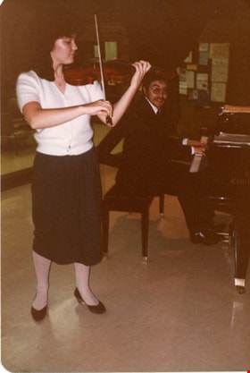
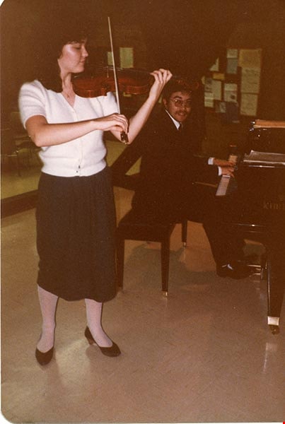
- Note in black ink on verso of photograph 142-001 reads: "Jamie Parker in '82 at Cofed. House Albert St. in Burnaby"
- Note in blue ink on verso of photograph 142-001 reads: "Violinist ______?"
- Note in black ink on verso of photograph 142-003 reads: "Jamie Parker in recital"
Images
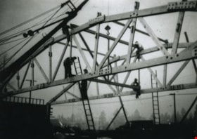
Construction of the Westminster Rollerway
https://search.heritageburnaby.ca/link/archivedescription37111
- Repository
- City of Burnaby Archives
- Date
- 1949
- Collection/Fonds
- Burnaby Historical Society fonds
- Description Level
- Item
- Physical Description
- 1 photograph : b&w ; 12.5 x 17.5 cm print + 6 p.
- Scope and Content
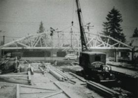
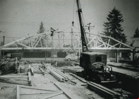
- Photograph of the construction of the Westminster Rollerway at 660 Edmonds Street (renumbered 7850 Edmonds Street). A "Commercial Truck Co. Ltd." construction crane is in the foreground.
- Repository
- City of Burnaby Archives
- Date
- 1949
- Collection/Fonds
- Burnaby Historical Society fonds
- Subseries
- Joe Russel subseries
- Physical Description
- 1 photograph : b&w ; 12.5 x 17.5 cm print + 6 p.
- Description Level
- Item
- Record No.
- 320-001
- Access Restriction
- No restrictions
- Reproduction Restriction
- Reproduce for fair dealing purposes only
- Accession Number
- BHS1995-14
- Scope and Content
- Photograph of the construction of the Westminster Rollerway at 660 Edmonds Street (renumbered 7850 Edmonds Street). A "Commercial Truck Co. Ltd." construction crane is in the foreground.
- Names
- Westminster Rollerway
- Media Type
- Photograph
- Notes
- Title based on contents of photograph
- Geographic Access
- Edmonds Street
- Historic Neighbourhood
- Edmonds (Historic Neighbourhood)
- Planning Study Area
- Edmonds Area
Images
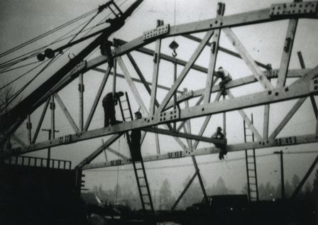
Construction of the Westminster Rollerway
https://search.heritageburnaby.ca/link/archivedescription37112
- Repository
- City of Burnaby Archives
- Date
- 1949
- Collection/Fonds
- Burnaby Historical Society fonds
- Description Level
- Item
- Physical Description
- 1 photograph : b&w ; 12.5 x 17.5 cm print
- Scope and Content
- Photograph of the construction of the Westminster Rollerway at 660 Edmonds Street (renumbered 7850 Edmonds Street). Construction workers are standing and sitting on the frame of the building, adding to it.
- Repository
- City of Burnaby Archives
- Date
- 1949
- Collection/Fonds
- Burnaby Historical Society fonds
- Subseries
- Joe Russel subseries
- Physical Description
- 1 photograph : b&w ; 12.5 x 17.5 cm print
- Description Level
- Item
- Record No.
- 320-002
- Access Restriction
- No restrictions
- Reproduction Restriction
- Reproduce for fair dealing purposes only
- Accession Number
- BHS1995-14
- Scope and Content
- Photograph of the construction of the Westminster Rollerway at 660 Edmonds Street (renumbered 7850 Edmonds Street). Construction workers are standing and sitting on the frame of the building, adding to it.
- Subjects
- Construction
- Occupations - Labourers
- Names
- Westminster Rollerway
- Media Type
- Photograph
- Notes
- Title based on contents of photograph
- Geographic Access
- Edmonds Street
- Historic Neighbourhood
- Edmonds (Historic Neighbourhood)
- Planning Study Area
- Edmonds Area
Images
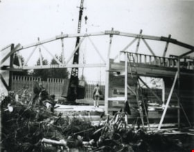
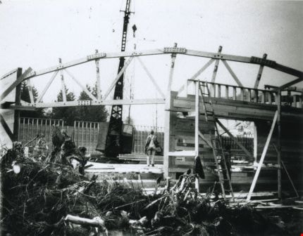
Construction of the Westminster Rollerway
https://search.heritageburnaby.ca/link/archivedescription37113
- Repository
- City of Burnaby Archives
- Date
- 1949
- Collection/Fonds
- Burnaby Historical Society fonds
- Description Level
- Item
- Physical Description
- 1 photograph : b&w ; 12.5 x 17.5 cm print
- Scope and Content
- Photograph of the construction of the Westminster Rollerway at 660 Edmonds Street (renumbered 7850 Edmonds Street). The construction workers have begun building the wooden walls of the building.
- Repository
- City of Burnaby Archives
- Date
- 1949
- Collection/Fonds
- Burnaby Historical Society fonds
- Subseries
- Joe Russel subseries
- Physical Description
- 1 photograph : b&w ; 12.5 x 17.5 cm print
- Description Level
- Item
- Record No.
- 320-003
- Access Restriction
- No restrictions
- Reproduction Restriction
- Reproduce for fair dealing purposes only
- Accession Number
- BHS1995-14
- Scope and Content
- Photograph of the construction of the Westminster Rollerway at 660 Edmonds Street (renumbered 7850 Edmonds Street). The construction workers have begun building the wooden walls of the building.
- Subjects
- Construction
- Occupations - Labourers
- Names
- Westminster Rollerway
- Media Type
- Photograph
- Notes
- Title based on contents of photograph
- Geographic Access
- Edmonds Street
- Historic Neighbourhood
- Edmonds (Historic Neighbourhood)
- Planning Study Area
- Edmonds Area
Images
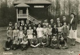
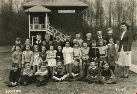
Seaforth School Class
https://search.heritageburnaby.ca/link/archivedescription37340
- Repository
- City of Burnaby Archives
- Date
- 1949
- Collection/Fonds
- Burnaby Historical Society fonds
- Description Level
- Item
- Physical Description
- 1 photograph : b&w ; 12.7 x 17.7 cm
- Scope and Content
- Photograph of twenty-nine students and their teacher seated and standing in rows in front of the school building. A label on the back of the photograph states that the students are from Seaforth School. Identified are the following, back row (l to r): Calvert Broomfield, Billy Beaton, Rod Cardin, …
- Repository
- City of Burnaby Archives
- Date
- 1949
- Collection/Fonds
- Burnaby Historical Society fonds
- Subseries
- Seaforth School subseries
- Physical Description
- 1 photograph : b&w ; 12.7 x 17.7 cm
- Description Level
- Item
- Record No.
- 355-004
- Access Restriction
- No restrictions
- Reproduction Restriction
- Reproduce for fair dealing purposes only
- Accession Number
- BHS1997-14
- Scope and Content
- Photograph of twenty-nine students and their teacher seated and standing in rows in front of the school building. A label on the back of the photograph states that the students are from Seaforth School. Identified are the following, back row (l to r): Calvert Broomfield, Billy Beaton, Rod Cardin, Brian Smith, Connor Werts, Charlie Sunderland, David Werts, John Short, Edward Green, Brude Johnson and Mrs. Mary Johnson (nee Mary MacDonald). Middle row (l to r): Judy Haddon, Sharon Milne, Barbara Smith, Wilma Heather, Betty Hadfield, Merle Beaton, Marcia Noel, Beverly Clarke, Janet Hadfield, Beverly Gamble, Lillian Savage and Joan Dachiuk. Front row (l to r): Billy Smith, Jerry Green, Leigh Tucker, David Park, Eldon Clarke, Joe Haddon and Sammy Savage.
- Names
- Seaforth School
- Johnson, Mary MacDonald
- Broomfield, Calvert
- Beaton, Billy
- Cardin, Rod
- Smith, Brian
- Werts, Connor
- Sunderland, Charlie
- Werts, David
- Short, John
- Green, Edward
- Johnson, Bruce
- Haddon, Judy
- Milne, Sharon
- Smith, Barbara
- Heather, Wilma
- Hadfield, Betty
- Beaton, Merle
- Noel, Marcia
- Clarke, Beverly
- Hadfield, Janet
- Gamble, Beverly
- Savage, Lillian
- Dachiuk, Joan
- Smith, Billy
- Green, Gerry
- Tucker, Leigh
- Park, David
- Clarke, Eldon
- Haddon, Joe
- Savage, Sammy
- Media Type
- Photograph
- Notes
- Title based on label on verso of photograph
- Photographer identified as "Layton"
- Geographic Access
- Government Road
- Deer Lake Avenue
- Street Address
- 7881 Government Road
- 6501 Deer Lake Avenue
- Historic Neighbourhood
- Lozells (Historic Neighbourhood)
- Planning Study Area
- Government Road Area
Images

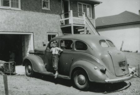
Cliff Anderson and his car
https://search.heritageburnaby.ca/link/archivedescription37431
- Repository
- City of Burnaby Archives
- Date
- 1949 (date of original), copied 1991
- Collection/Fonds
- Burnaby Historical Society fonds
- Description Level
- Item
- Physical Description
- 1 photograph : b&w ; 2.9 x 4.2 cm print on contact sheet 20.2 x 25.3 cm
- Scope and Content
- Photograph of Cliff Anderson standing on the running board of a 1937 Dodge in the backyard of 4437 Norland Avenue (later renumbered 3908 Norland Avenue).
- Repository
- City of Burnaby Archives
- Date
- 1949 (date of original), copied 1991
- Collection/Fonds
- Burnaby Historical Society fonds
- Subseries
- Burnaby Image Bank subseries
- Physical Description
- 1 photograph : b&w ; 2.9 x 4.2 cm print on contact sheet 20.2 x 25.3 cm
- Description Level
- Item
- Record No.
- 370-019
- Access Restriction
- No restrictions
- Reproduction Restriction
- Reproduce for fair dealing purposes only
- Accession Number
- BHS1999-03
- Scope and Content
- Photograph of Cliff Anderson standing on the running board of a 1937 Dodge in the backyard of 4437 Norland Avenue (later renumbered 3908 Norland Avenue).
- Subjects
- Transportation - Automobiles
- Names
- Anderson, Cliff
- Media Type
- Photograph
- Notes
- Title based on contents of photograph
- 1 b&w copy negative accompanying
- Geographic Access
- Norland Avenue
- Street Address
- 3908 Norland Avenue
- Historic Neighbourhood
- Burnaby Lake (Historic Neighbourhood)
- Planning Study Area
- Douglas-Gilpin Area
Images
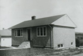
Anderson family home
https://search.heritageburnaby.ca/link/archivedescription37432
- Repository
- City of Burnaby Archives
- Date
- 1949 (date of original), copied 1991
- Collection/Fonds
- Burnaby Historical Society fonds
- Description Level
- Item
- Physical Description
- 1 photograph : b&w ; 3.2 x 4.2 cm print on contact sheet 20.2 x 25.3 cm
- Scope and Content
- Photograph of the front of the Anderson family home at 4437 Norland Avenue (later renumbered 3908 Norland Avenue). Robert and Madelaine Anderson lived here with their family.
- Repository
- City of Burnaby Archives
- Date
- 1949 (date of original), copied 1991
- Collection/Fonds
- Burnaby Historical Society fonds
- Subseries
- Burnaby Image Bank subseries
- Physical Description
- 1 photograph : b&w ; 3.2 x 4.2 cm print on contact sheet 20.2 x 25.3 cm
- Description Level
- Item
- Record No.
- 370-020
- Access Restriction
- No restrictions
- Reproduction Restriction
- No restrictions
- Accession Number
- BHS1999-03
- Scope and Content
- Photograph of the front of the Anderson family home at 4437 Norland Avenue (later renumbered 3908 Norland Avenue). Robert and Madelaine Anderson lived here with their family.
- Subjects
- Buildings - Residential - Houses
- Media Type
- Photograph
- Notes
- Title based on contents of photograph
- 1 b&w copy negative accompanying
- Geographic Access
- Norland Avenue
- Street Address
- 3908 Norland Avenue
- Historic Neighbourhood
- Burnaby Lake (Historic Neighbourhood)
- Planning Study Area
- Douglas-Gilpin Area
Images
