Narrow Results By
Subject
- Agricultural Tools and Equipment 1
- Agriculture - Crops 2
- Agriculture - Farms 3
- Animals - Dogs 1
- Animals - Horses 1
- Buildings - Residential - Cabins 1
- Buildings - Residential - Houses 8
- Construction 2
- Geographic Features - Gardens 1
- Industries - Forestry 2
- Industries - Logging/lumber 2
- Land Clearing 1

Topping a tree near Central Park
https://search.heritageburnaby.ca/link/archivedescription37280
- Repository
- City of Burnaby Archives
- Date
- 1904
- Collection/Fonds
- Burnaby Historical Society fonds
- Description Level
- Item
- Physical Description
- 1 photograph : sepia toned ; 21 x 26.5 cm
- Scope and Content
- Photograph of a man "topping" a large tree in the area near Central Park and Boundary Road.
- Repository
- City of Burnaby Archives
- Date
- 1904
- Collection/Fonds
- Burnaby Historical Society fonds
- Subseries
- Norah Code subseries
- Physical Description
- 1 photograph : sepia toned ; 21 x 26.5 cm
- Description Level
- Item
- Record No.
- 345-001
- Access Restriction
- No restrictions
- Reproduction Restriction
- No known restrictions
- Accession Number
- BHS1997-05
- Scope and Content
- Photograph of a man "topping" a large tree in the area near Central Park and Boundary Road.
- Media Type
- Photograph
- Photographer
- Code, Norah
- Notes
- Title based on contents of photograph
- Photographs in this collection were taken and compiled by Norah Code, former editor of the "Burnaby Courier" newspaper during the course of her work for the newspaper. A note with the file indicates that the man in the tree may be Ms. Code's father but his name is not provided.
- Geographic Access
- Boundary Road
- Central Park
- Historic Neighbourhood
- Central Park (Historic Neighbourhood)
- Planning Study Area
- Maywood Area
Images

![Survey and Subdivision plans in New Westminster District Group 1 – Burnaby, [1905-1917] thumbnail](/media/hpo/_Data/_BVM_Cartographic_Material/1977/1977_0093_0022a_001.jpg?width=280)
Survey and Subdivision plans in New Westminster District Group 1 – Burnaby
https://search.heritageburnaby.ca/link/museumdescription6991
- Repository
- Burnaby Village Museum
- Date
- [1905-1917]
- Collection/Fonds
- Burnaby Village Museum Map collection
- Description Level
- File
- Physical Description
- 12 plans : 6 black ink on paper + 2 black & col. ink on paper + 4 graphite on paper
- Scope and Content
- Item consists of a large board of six New Westminster District subdivision plans mounted on one side and six New Westminster District subdivision plans mounted on the other side. Side A: 1. Plan drawn in graphite with markings in black ink "Surveyed for Mr. W. Wilson / Paterson Stat. B.C.E.R." . …
- Repository
- Burnaby Village Museum
- Collection/Fonds
- Burnaby Village Museum Map collection
- Description Level
- File
- Physical Description
- 12 plans : 6 black ink on paper + 2 black & col. ink on paper + 4 graphite on paper
- Material Details
- Scales [between 1:360 and 1:3168]
- Index number on edge of board reads: "22"
- Scope and Content
- Item consists of a large board of six New Westminster District subdivision plans mounted on one side and six New Westminster District subdivision plans mounted on the other side. Side A: 1. Plan drawn in graphite with markings in black ink "Surveyed for Mr. W. Wilson / Paterson Stat. B.C.E.R." . Plan includes subdivision of lots situated between B.C.E. Railway and Vancouver Road (Kingsway). (Geographic location: Burnaby) 2. Subdivision plan (no title) drawn in black ink with annotations in graphite. Plan covers District Lots 2, 4 and 6, west of North Road. Plan is stamped: "Albert J. Hill, Civil Engineer / and / Provincial Land Surveyor, / New Westminster, / B.C. (Geographic location: Burnaby) 3. Plan of "Portion of Municipality" with intials "RB" [sic] (handwritten in blue crayon). Plan covers the area north east of the City of New Westminster including District Lots 11, 13, 14, 12, 1 and 2. Plan is stamped: "Albert J. Hill, Civil Engineer / and / Provincial Land Surveyor, / New Westminster, / B.C. (Geographic location: Burnaby) 4."Plan / of Subdivision of / N.W.1/4 Lot 175 / Group 1 New West. Dist. / B.C. / Scale 4 chs = 1 in. " Plan is stamped: "Albert J. Hill, Civil Engineer / and / Provincial Land Surveyor, / New Westminster, / B.C. and initialed : "RB" [sic] (in blue pencil crayon) (Geographic location: Burnaby) 5. "Subdivision / of a Portion of / Lot 15 Group 1 / New Westminster Dist. / Scale 4 chs = 1 in". Plan provides numbered sudivisions - Lots 1 to 15 of District Lot 15 in red ink. (Geographic location: Burnaby) 6. Plan of "Central Park & / Vicinity" Plan includes subdivisions of District Lot 153 east of Central Park District Lot 151 and subdivision of District Lot 36 and 49 west of Boundary Road (Vancouver). Plan is stamped: "Albert J. Hill, Civil Engineer / and / Provincial Land Surveyor, / New Westminster, / B.C. and initialed : "RB" [sic] (in blue pencil crayon). (Geographic location: Burnaby) Side B: 1. Subdivision plan (no title) drawn in black ink. Plan identifies lots between Vancouver Road (Yale Road is crossed out and replaced with Vancouver Road) and B.C.E. Railway. "Scale 2 chs = 1 in" (Geographic location: Burnaby) 2. Plan of "Subdivision Lot 1 / Lot 69 Gr. 1 / Scale 30' = 1 " " Plan identifies Boundary Road, Still Creek and a Road Allowance between District Lot 118 and District Lot 69. Plan was "Surveyed for Burnaby Mun. Council / March 11th 1908 / G.K.B." (Geographic location: Burnaby) 3. Plan drawn in black ink (no title) showing a subdivision in Lot 25 with names "Newcomb", "Debeck" and "Armstrong" along with roads identified as Third Street, Cumberland Street, Armstrong Street and Cariboo [sic] Street and including Lots 27, 11 and 13.Plan is stamped: "Albert J. Hill, Civil Engineer / and / Provincial Land Surveyor, / New Westminster, / B.C. and initialed : "RB" [sic] (in blue pencil crayon). (Geographic location: Burnaby) 4. Handrawn subdivision plan in graphite titled: "Lot 13, Gr.1" with intials "RB" [sic] (handwritten in blue crayon). Plan is bordered by Armstrong Street (Lot 11, G.1), Cumberland St. (Lot 25, G.1) and Tenth Avenue (City Boundary). The plan is singed by "Albert J. Hill / P.L.S." and one of the subdivided lots is identified with the name: "W. Karrymann". (Geographic location: Burnaby) 5. Handrawn sketch in graphite titled: "Lot 88, Gr.1" with intials "RB" [sic] (handwritten in blue crayon). Plan appears to be a draft of a subdivision plan of a portion of District Lot 88 along Cumberland Road. The plan is signed: "16/7/17 _W.F. Draper [sic] / B.C.L.S." (Geographic location: Burnaby) 6. "Plan / of Subdivision / of Blocks 61, 62 and 2 / Lot 30 / Group 1 / N.W. Dist. / Scale 1ch = 1 in". Plan is intialed by: "PB" with a note: "Also see board 2 / for duplicate" (handwritten in blue crayon). (Geographic location: Burnaby)
- Creator
- Hill, Albert James
- Geographic Access
- Boundary Road
- Kingsway
- Cumberland Street
- Accession Code
- HV977.93.22
- Access Restriction
- No restrictions
- Reproduction Restriction
- No known restrictions
- Date
- [1905-1917]
- Media Type
- Cartographic Material
- Historic Neighbourhood
- Central Park (Historic Neighbourhood)
- Scan Resolution
- 300
- Scale
- 100
- Notes
- Title based on contents of file
- Scale is measured in chains and feet. (One chain equals 792 inches)
- The term "Lot" can also refer to a "District Lot”
- Some plans are stamped: "Albert J. Hill, Civil Engineer / and / Provincial Land Surveyor, / New Westminster, / B.C." and intialed: "RB" [sic]
Images
![Survey and Subdivision plans in New Westminster District Group 1 – Burnaby, [1905-1917] thumbnail](/media/hpo/_Data/_BVM_Cartographic_Material/1977/1977_0093_0022a_001.jpg)

![Lumber Camp and Mill, [between 1906 and 1908] thumbnail](/media/hpo/_Data/_Archives_Images/_Unrestricted/371/375-029.jpg?width=280)
Lumber Camp and Mill
https://search.heritageburnaby.ca/link/archivedescription38267
- Repository
- City of Burnaby Archives
- Date
- [between 1906 and 1908]
- Collection/Fonds
- Burnaby Historical Society fonds
- Description Level
- Item
- Physical Description
- 1 photograph : sepia ; 11.8 x 17 cm on 17.7 x 22.7 cm backing
- Scope and Content
- Photograph of the Nicholson lumber camp and mill in the Broadview area of Burnaby. Approximately 12 men and women can be seen standing in front of the cabins and piles of planks (all are unidentified).
- Repository
- City of Burnaby Archives
- Date
- [between 1906 and 1908]
- Collection/Fonds
- Burnaby Historical Society fonds
- Subseries
- Margaret McCallum subseries
- Physical Description
- 1 photograph : sepia ; 11.8 x 17 cm on 17.7 x 22.7 cm backing
- Description Level
- Item
- Record No.
- 375-029
- Access Restriction
- No restrictions
- Reproduction Restriction
- No known restrictions
- Accession Number
- BHS1986-42
- Scope and Content
- Photograph of the Nicholson lumber camp and mill in the Broadview area of Burnaby. Approximately 12 men and women can be seen standing in front of the cabins and piles of planks (all are unidentified).
- Subjects
- Buildings - Residential - Cabins
- Industries - Forestry
- Occupations - Lumberjacks
- Industries - Logging/lumber
- Media Type
- Photograph
- Notes
- Title based on caption
- A note on the back of the photograph reads: "Lumber camp and mill at Boundary Road and Great Northern Railway 1906-1908 (before railway existed)."
- Geographic Access
- Boundary Road
- Street Address
- 2550 Boundary Road
- Historic Neighbourhood
- Broadview (Historic Neighbourhood)
- Planning Study Area
- West Central Valley Area
Images
![Lumber Camp and Mill, [between 1906 and 1908] thumbnail](/media/hpo/_Data/_Archives_Images/_Unrestricted/371/375-029.jpg)

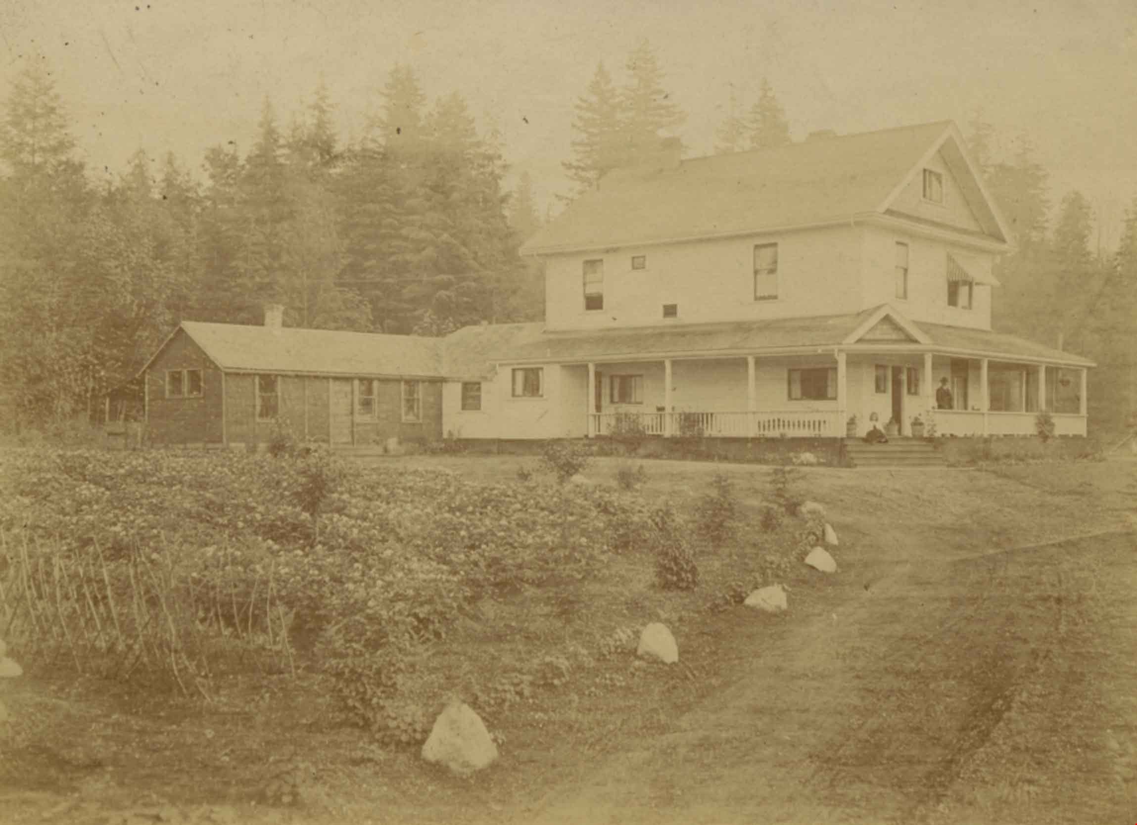
L. Claude Hill's Farm, Burnaby BC
https://search.heritageburnaby.ca/link/archivedescription39550
- Repository
- City of Burnaby Archives
- Date
- 1906
- Collection/Fonds
- Peers Family and Hill Family fonds
- Description Level
- Item
- Physical Description
- 1 photograph : b&w ; 12.5 x 17.5 cm on page 21.5 x 28 cm (pasted in album)
- Scope and Content
- Photograph looking towards the Pole Line Road (later Sperling Avenue) from the farm belonging to Claude Hill and known as Broadview on Buckingham Avenue. This property formerly belonged to Malcolm Nicholson. A fence can be seen dividing the garden from the field and two men are standing alongside…
- Repository
- City of Burnaby Archives
- Date
- 1906
- Collection/Fonds
- Peers Family and Hill Family fonds
- Physical Description
- 1 photograph : b&w ; 12.5 x 17.5 cm on page 21.5 x 28 cm (pasted in album)
- Description Level
- Item
- Record No.
- 477-869
- Access Restriction
- No restrictions
- Reproduction Restriction
- No known restrictions
- Accession Number
- 2007-12
- Scope and Content
- Photograph looking towards the Pole Line Road (later Sperling Avenue) from the farm belonging to Claude Hill and known as Broadview on Buckingham Avenue. This property formerly belonged to Malcolm Nicholson. A fence can be seen dividing the garden from the field and two men are standing alongside with a horse and carriage nearby. Four children are walking in the field - from left to right, Kitty Hill, Ed Clayton, Gerry Hill and Florence Hart . A house can be seen in the background, this is most likely the cottage belonging to Harriet Woodward which served as the first school and post office at Burnaby Lake. To the right of the Woodward house can be seen the roof of the Claude Hill house known as Brookfield which was at 6501 Deer Lake Avenue and above that is a house on a hill which was the George Clayton home (on what later became the Henry and Grace Ceperley Fairacres estate at 6344 Deer Lake Avenue).
- Names
- Clayton, Edward
- Godwin, Florence Hart
- Hill, Minard Gerald "Gerry"
- Peers, Katherine Maude Hill "Kitty"
- Media Type
- Photograph
- Photographer
- Cooksley, William Thomas
- Notes
- Title based on caption accompanying photograph
- Geographic Access
- Deer Lake Avenue
- Buckingham Avenue
- Sperling Avenue
- Street Address
- 6501 Deer Lake Avenue
- 5141 Sperling Avenue
- 5730 Buckingham Avenue
- Historic Neighbourhood
- Burnaby Lake (Historic Neighbourhood)
- Planning Study Area
- Morley-Buckingham Area
Images

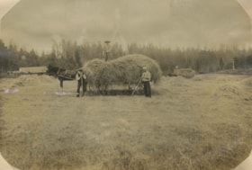
Haying at Broadview
https://search.heritageburnaby.ca/link/archivedescription39551
- Repository
- City of Burnaby Archives
- Date
- 1906
- Collection/Fonds
- Peers Family and Hill Family fonds
- Description Level
- Item
- Physical Description
- 1 photograph : b&w ; 11 x 16 cm on page 21.5 x 28 cm (pasted in album)
- Scope and Content
- Photograph of farmers in the field gathering hay with horse and wagons. In the middle of the photograph three men pose with a horse and hay wagon. The man on the right (with white shirt) is Bernard Hill. The bearded man may be Malcolm Nicholson (from whom Claude Hill bought the land to build his h…
- Repository
- City of Burnaby Archives
- Date
- 1906
- Collection/Fonds
- Peers Family and Hill Family fonds
- Physical Description
- 1 photograph : b&w ; 11 x 16 cm on page 21.5 x 28 cm (pasted in album)
- Description Level
- Item
- Record No.
- 477-870
- Access Restriction
- No restrictions
- Reproduction Restriction
- No known restrictions
- Accession Number
- 2007-12
- Scope and Content
- Photograph of farmers in the field gathering hay with horse and wagons. In the middle of the photograph three men pose with a horse and hay wagon. The man on the right (with white shirt) is Bernard Hill. The bearded man may be Malcolm Nicholson (from whom Claude Hill bought the land to build his home, Broadview). The other man is unidentified. This photograph was taken on the Broadview site, looking south, roughly at the corner of Sperling Avenue and Rugby Avenue, towards Buckingham Avenue.
- Names
- Hill, Bernard R.
- Media Type
- Photograph
- Notes
- Title based on contents of photograph
- Geographic Access
- Buckingham Avenue
- Sperling Avenue
- Rugby Street
- Historic Neighbourhood
- Burnaby Lake (Historic Neighbourhood)
- Planning Study Area
- Morley-Buckingham Area
Images

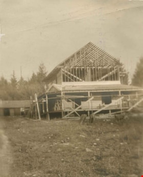
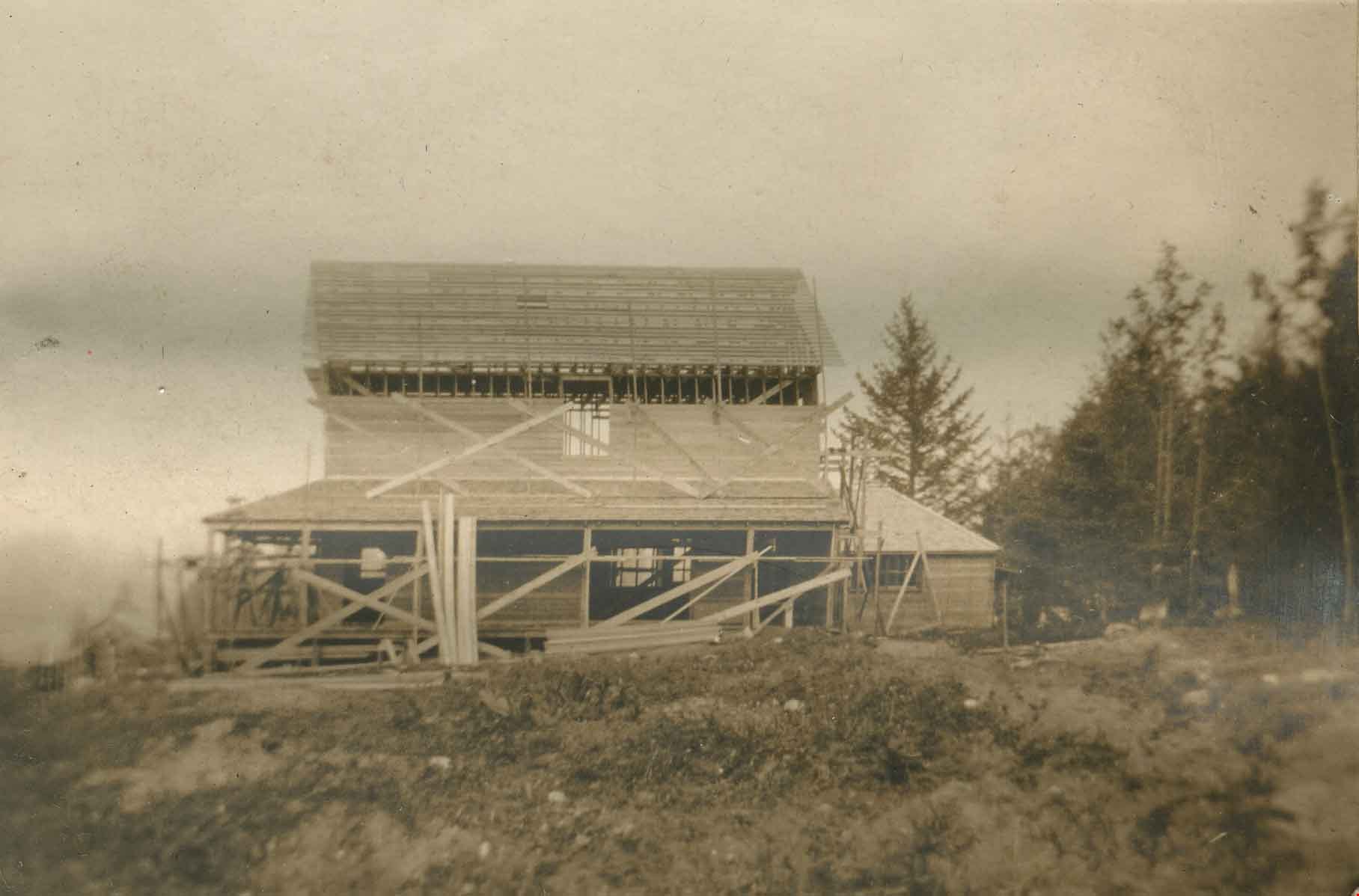
Building Broadview
https://search.heritageburnaby.ca/link/archivedescription39554
- Repository
- City of Burnaby Archives
- Date
- 1907
- Collection/Fonds
- Peers Family and Hill Family fonds
- Description Level
- Item
- Physical Description
- 1 photograph : b&w ; 5.2 x 6.3 cm on page 21.5 x 28 cm (pasted in album)
- Scope and Content
- Photograph of the building of Broadview, the home belonging to Claude Hill on Buckingham Avenue. Shown here under construction, Broadview was finished around 1907 and was the second home for the Hill family in the Burnaby Lake area. The first, Brookfield, was on Deer Lake Avenue.
- Repository
- City of Burnaby Archives
- Date
- 1907
- Collection/Fonds
- Peers Family and Hill Family fonds
- Physical Description
- 1 photograph : b&w ; 5.2 x 6.3 cm on page 21.5 x 28 cm (pasted in album)
- Description Level
- Item
- Record No.
- 477-873
- Access Restriction
- No restrictions
- Reproduction Restriction
- No known restrictions
- Accession Number
- 2007-12
- Scope and Content
- Photograph of the building of Broadview, the home belonging to Claude Hill on Buckingham Avenue. Shown here under construction, Broadview was finished around 1907 and was the second home for the Hill family in the Burnaby Lake area. The first, Brookfield, was on Deer Lake Avenue.
- Media Type
- Photograph
- Notes
- Title based on contents of photograph
- Geographic Access
- Buckingham Avenue
- Street Address
- 5730 Buckingham Avenue
- Historic Neighbourhood
- Burnaby Lake (Historic Neighbourhood)
- Planning Study Area
- Morley-Buckingham Area
Images

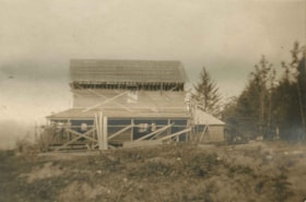
Broadview under construction
https://search.heritageburnaby.ca/link/archivedescription39555
- Repository
- City of Burnaby Archives
- Date
- 1907
- Collection/Fonds
- Peers Family and Hill Family fonds
- Description Level
- Item
- Physical Description
- 1 photograph : b&w ; 5.3 x 7.8 cm on page 21.5 x 28 cm (pasted in album)
- Scope and Content
- Photograph of the building of Broadview, the home belonging to Claude Hill on Buckingham Avenue. Shown here under construction, Broadview was finished around 1907 and was the second home for the Hill family in the Burnaby Lake area. The first, Brookfield, was on Deer Lake Avenue.
- Repository
- City of Burnaby Archives
- Date
- 1907
- Collection/Fonds
- Peers Family and Hill Family fonds
- Physical Description
- 1 photograph : b&w ; 5.3 x 7.8 cm on page 21.5 x 28 cm (pasted in album)
- Description Level
- Item
- Record No.
- 477-874
- Access Restriction
- No restrictions
- Reproduction Restriction
- No known restrictions
- Accession Number
- 2007-12
- Scope and Content
- Photograph of the building of Broadview, the home belonging to Claude Hill on Buckingham Avenue. Shown here under construction, Broadview was finished around 1907 and was the second home for the Hill family in the Burnaby Lake area. The first, Brookfield, was on Deer Lake Avenue.
- Media Type
- Photograph
- Notes
- Title based on contents of photograph
- Geographic Access
- Buckingham Avenue
- Street Address
- 5730 Buckingham Avenue
- Historic Neighbourhood
- Burnaby Lake (Historic Neighbourhood)
- Planning Study Area
- Morley-Buckingham Area
Images

Boundary Road Lumber Mill
https://search.heritageburnaby.ca/link/archivedescription38262
- Repository
- City of Burnaby Archives
- Date
- 1908
- Collection/Fonds
- Burnaby Historical Society fonds
- Description Level
- Item
- Physical Description
- 1 photograph : sepia ; 9 x 12 cm on 12.5 x 15 cm backing
- Scope and Content
- Photograph of an unidentified man standing in the forefront with a jersey cow to the right, while a row of cabins and cleared tress can be seen in the background. A caption written above the photograph reads: "Boundary Road Lumber Mill owned by E.W. Nicholson." Underneath the photograph is writte…
- Repository
- City of Burnaby Archives
- Date
- 1908
- Collection/Fonds
- Burnaby Historical Society fonds
- Subseries
- Margaret McCallum subseries
- Physical Description
- 1 photograph : sepia ; 9 x 12 cm on 12.5 x 15 cm backing
- Description Level
- Item
- Record No.
- 375-024
- Access Restriction
- No restrictions
- Reproduction Restriction
- No known restrictions
- Accession Number
- BHS1986-42
- Scope and Content
- Photograph of an unidentified man standing in the forefront with a jersey cow to the right, while a row of cabins and cleared tress can be seen in the background. A caption written above the photograph reads: "Boundary Road Lumber Mill owned by E.W. Nicholson." Underneath the photograph is written: "The first Jersey cow on the farm." On the back of the photograph it is noted that the buildings in the background were workmen's buildings.
- Media Type
- Photograph
- Notes
- Title based on caption
- Geographic Access
- Boundary Road
- Still Creek
- Street Address
- 2550 Boundary Road
- Historic Neighbourhood
- Broadview (Historic Neighbourhood)
- Planning Study Area
- West Central Valley Area
Images

![Horse pulling a sleigh, [1908] thumbnail](/media/hpo/_Data/_Archives_Images/_Unrestricted/477/477-562.jpg?width=280)
Horse pulling a sleigh
https://search.heritageburnaby.ca/link/archivedescription39243
- Repository
- City of Burnaby Archives
- Date
- [1908]
- Collection/Fonds
- Peers Family and Hill Family fonds
- Description Level
- Item
- Physical Description
- 1 photograph : sepia ; 4.5 x 9.5 cm on page 24.5 x 32.5 cm (pasted in album)
- Scope and Content
- Photograph of a horse pulling a sleigh in the snow. Two adults and a child can be seen sitting in the sleigh, all unidentified. The photograph was taken at Broadview, the home of Claude Hill in the Burnaby Lake area.
- Repository
- City of Burnaby Archives
- Date
- [1908]
- Collection/Fonds
- Peers Family and Hill Family fonds
- Physical Description
- 1 photograph : sepia ; 4.5 x 9.5 cm on page 24.5 x 32.5 cm (pasted in album)
- Description Level
- Item
- Record No.
- 477-562
- Access Restriction
- No restrictions
- Reproduction Restriction
- No known restrictions
- Accession Number
- 2007-12
- Scope and Content
- Photograph of a horse pulling a sleigh in the snow. Two adults and a child can be seen sitting in the sleigh, all unidentified. The photograph was taken at Broadview, the home of Claude Hill in the Burnaby Lake area.
- Media Type
- Photograph
- Notes
- Title based on contents of photograph
- Geographic Access
- Buckingham Avenue
- Street Address
- 5730 Buckingham Avenue
- Historic Neighbourhood
- Burnaby Lake (Historic Neighbourhood)
- Planning Study Area
- Morley-Buckingham Area
Images
![Horse pulling a sleigh, [1908] thumbnail](/media/hpo/_Data/_Archives_Images/_Unrestricted/477/477-562.jpg)
![Broadview in the winter, [1908] thumbnail](/media/hpo/_Data/_Archives_Images/_Unrestricted/477/477-563.jpg?width=280)
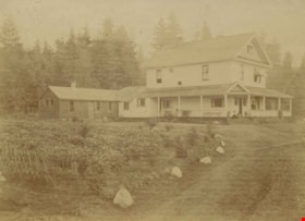
Broadview in the winter
https://search.heritageburnaby.ca/link/archivedescription39244
- Repository
- City of Burnaby Archives
- Date
- [1908]
- Collection/Fonds
- Peers Family and Hill Family fonds
- Description Level
- Item
- Physical Description
- 1 photograph : b&w ; 6.8 x 9.5 cm on page 24.5 x 32.5 cm (pasted in album)
- Scope and Content
- Photograph of Broadview, the home of Claude Hill and his family in the Burnaby Lake area. A girl, probably Claude's daughter Kitty Hill, can be seen standing next to a post on the veranda of the house.
- Repository
- City of Burnaby Archives
- Date
- [1908]
- Collection/Fonds
- Peers Family and Hill Family fonds
- Physical Description
- 1 photograph : b&w ; 6.8 x 9.5 cm on page 24.5 x 32.5 cm (pasted in album)
- Description Level
- Item
- Record No.
- 477-563
- Access Restriction
- No restrictions
- Reproduction Restriction
- No known restrictions
- Accession Number
- 2007-12
- Scope and Content
- Photograph of Broadview, the home of Claude Hill and his family in the Burnaby Lake area. A girl, probably Claude's daughter Kitty Hill, can be seen standing next to a post on the veranda of the house.
- Media Type
- Photograph
- Notes
- Title based on contents of photograph
- Geographic Access
- Buckingham Avenue
- Street Address
- 5730 Buckingham Avenue
- Historic Neighbourhood
- Burnaby Lake (Historic Neighbourhood)
- Planning Study Area
- Morley-Buckingham Area
Images
![Broadview in the winter, [1908] thumbnail](/media/hpo/_Data/_Archives_Images/_Unrestricted/477/477-563.jpg)
![Broadview in the winter, [1908] thumbnail](/media/hpo/_Data/_Archives_Images/_Unrestricted/477/477-564.jpg?width=280)
Broadview in the winter
https://search.heritageburnaby.ca/link/archivedescription39245
- Repository
- City of Burnaby Archives
- Date
- [1908]
- Collection/Fonds
- Peers Family and Hill Family fonds
- Description Level
- Item
- Physical Description
- 1 photograph : b&w ; 7.2 x 8 cm on page 24.5 x 32.5 cm (pasted in album)
- Scope and Content
- Photograph of Broadview, the home of Claude Hill and his family in the Burnaby Lake area. A girl, probably Claude's daughter Kitty Hill can be seen sitting on the railing of the house, to the far right.
- Repository
- City of Burnaby Archives
- Date
- [1908]
- Collection/Fonds
- Peers Family and Hill Family fonds
- Physical Description
- 1 photograph : b&w ; 7.2 x 8 cm on page 24.5 x 32.5 cm (pasted in album)
- Description Level
- Item
- Record No.
- 477-564
- Access Restriction
- No restrictions
- Reproduction Restriction
- No known restrictions
- Accession Number
- 2007-12
- Scope and Content
- Photograph of Broadview, the home of Claude Hill and his family in the Burnaby Lake area. A girl, probably Claude's daughter Kitty Hill can be seen sitting on the railing of the house, to the far right.
- Media Type
- Photograph
- Notes
- Title based on contents of photograph
- Geographic Access
- Buckingham Avenue
- Street Address
- 5730 Buckingham Avenue
- Historic Neighbourhood
- Burnaby Lake (Historic Neighbourhood)
- Planning Study Area
- Morley-Buckingham Area
Images
![Broadview in the winter, [1908] thumbnail](/media/hpo/_Data/_Archives_Images/_Unrestricted/477/477-564.jpg)
![Group of Children in front of Broadview, [1908] thumbnail](/media/hpo/_Data/_Archives_Images/_Unrestricted/477/477-565.jpg?width=280)
Group of Children in front of Broadview
https://search.heritageburnaby.ca/link/archivedescription39246
- Repository
- City of Burnaby Archives
- Date
- [1908]
- Collection/Fonds
- Peers Family and Hill Family fonds
- Description Level
- Item
- Physical Description
- 1 photograph : b&w ; 4.4 x 6 cm on page 24.5 x 32.5 cm (pasted in album)
- Scope and Content
- Photograph of a group of children, all unknown, standing next to a house identified as Broadview, the home of Claude Hill and his family in the Burnaby Lake area. A small dog is standing in front of the children, being held in place by a boy in the front row.
- Repository
- City of Burnaby Archives
- Date
- [1908]
- Collection/Fonds
- Peers Family and Hill Family fonds
- Physical Description
- 1 photograph : b&w ; 4.4 x 6 cm on page 24.5 x 32.5 cm (pasted in album)
- Description Level
- Item
- Record No.
- 477-565
- Access Restriction
- No restrictions
- Reproduction Restriction
- No known restrictions
- Accession Number
- 2007-12
- Scope and Content
- Photograph of a group of children, all unknown, standing next to a house identified as Broadview, the home of Claude Hill and his family in the Burnaby Lake area. A small dog is standing in front of the children, being held in place by a boy in the front row.
- Subjects
- Animals - Dogs
- Media Type
- Photograph
- Notes
- Title based on contents of photograph
- Geographic Access
- Buckingham Avenue
- Street Address
- 5730 Buckingham Avenue
- Historic Neighbourhood
- Burnaby Lake (Historic Neighbourhood)
- Planning Study Area
- Morley-Buckingham Area
Images
![Group of Children in front of Broadview, [1908] thumbnail](/media/hpo/_Data/_Archives_Images/_Unrestricted/477/477-565.jpg)
![Broadview, [1908] thumbnail](/media/hpo/_Data/_Archives_Images/_Unrestricted/477/477-946.jpg?width=280)
Broadview
https://search.heritageburnaby.ca/link/archivedescription66233
- Repository
- City of Burnaby Archives
- Date
- [1908]
- Collection/Fonds
- Peers Family and Hill Family fonds
- Description Level
- Item
- Physical Description
- 1 photograph : b&w ; 5 x 8 cm (oval, sight) on sheet 15 x 22.5 cm
- Scope and Content
- Photograph of the second home of Claude Hill in the Burnaby Lake district. It was known as Broadview.
- Repository
- City of Burnaby Archives
- Date
- [1908]
- Collection/Fonds
- Peers Family and Hill Family fonds
- Physical Description
- 1 photograph : b&w ; 5 x 8 cm (oval, sight) on sheet 15 x 22.5 cm
- Description Level
- Item
- Record No.
- 477-946
- Access Restriction
- No restrictions
- Reproduction Restriction
- No known restrictions
- Accession Number
- 2007-12
- Scope and Content
- Photograph of the second home of Claude Hill in the Burnaby Lake district. It was known as Broadview.
- Subjects
- Buildings - Residential - Houses
- Media Type
- Photograph
- Notes
- Title based on contents of photograph
- Geographic Access
- Buckingham Avenue
- Street Address
- 5730 Buckingham Avenue
- Historic Neighbourhood
- Burnaby Lake (Historic Neighbourhood)
- Planning Study Area
- Morley-Buckingham Area
Images
![Broadview, [1908] thumbnail](/media/hpo/_Data/_Archives_Images/_Unrestricted/477/477-946.jpg)
![Broadview, [1908] thumbnail](/media/hpo/_Data/_Archives_Images/_Unrestricted/477/477-947.jpg?width=280)
Broadview
https://search.heritageburnaby.ca/link/archivedescription66234
- Repository
- City of Burnaby Archives
- Date
- [1908]
- Collection/Fonds
- Peers Family and Hill Family fonds
- Description Level
- Item
- Physical Description
- 1 photograph : 5.5 x 7.5 cm on sheet 15 x 22.5 cm
- Scope and Content
- Photograph of a horse standing in the field in front of "Broadview," the home of Claude Hill in the Burnaby Lake district.
- Repository
- City of Burnaby Archives
- Date
- [1908]
- Collection/Fonds
- Peers Family and Hill Family fonds
- Physical Description
- 1 photograph : 5.5 x 7.5 cm on sheet 15 x 22.5 cm
- Description Level
- Item
- Record No.
- 477-947
- Access Restriction
- No restrictions
- Reproduction Restriction
- No known restrictions
- Accession Number
- 2007-12
- Scope and Content
- Photograph of a horse standing in the field in front of "Broadview," the home of Claude Hill in the Burnaby Lake district.
- Subjects
- Buildings - Residential - Houses
- Media Type
- Photograph
- Notes
- Title based on contents of photograph
- Geographic Access
- Buckingham Avenue
- Street Address
- 5730 Buckingham Avenue
- Historic Neighbourhood
- Burnaby Lake (Historic Neighbourhood)
- Planning Study Area
- Morley-Buckingham Area
Images
![Broadview, [1908] thumbnail](/media/hpo/_Data/_Archives_Images/_Unrestricted/477/477-947.jpg)
![Kitty Hill with dog, [1908] thumbnail](/media/hpo/_Data/_Archives_Images/_Unrestricted/477/477-948.jpg?width=280)
Kitty Hill with dog
https://search.heritageburnaby.ca/link/archivedescription66235
- Repository
- City of Burnaby Archives
- Date
- [1908]
- Collection/Fonds
- Peers Family and Hill Family fonds
- Description Level
- Item
- Physical Description
- 1 photograph : b&w ; 5.5 x 7.5 cm on sheet 15 x 22.5 cm
- Scope and Content
- Photograph of Kitty Hill, holding a dog on her lap. The photograph was likely taken at the Hill family home, Broadview.
- Repository
- City of Burnaby Archives
- Date
- [1908]
- Collection/Fonds
- Peers Family and Hill Family fonds
- Physical Description
- 1 photograph : b&w ; 5.5 x 7.5 cm on sheet 15 x 22.5 cm
- Description Level
- Item
- Record No.
- 477-948
- Access Restriction
- No restrictions
- Reproduction Restriction
- No known restrictions
- Accession Number
- 2007-12
- Scope and Content
- Photograph of Kitty Hill, holding a dog on her lap. The photograph was likely taken at the Hill family home, Broadview.
- Subjects
- Buildings - Residential - Houses
- Media Type
- Photograph
- Notes
- Title based on contents of photograph
- Geographic Access
- Buckingham Avenue
- Street Address
- 5730 Buckingham Avenue
- Historic Neighbourhood
- Burnaby Lake (Historic Neighbourhood)
- Planning Study Area
- Morley-Buckingham Area
Images
![Kitty Hill with dog, [1908] thumbnail](/media/hpo/_Data/_Archives_Images/_Unrestricted/477/477-948.jpg)
![Farm workers, [1908] thumbnail](/media/hpo/_Data/_Archives_Images/_Unrestricted/477/477-949.jpg?width=280)
Farm workers
https://search.heritageburnaby.ca/link/archivedescription66236
- Repository
- City of Burnaby Archives
- Date
- [1908]
- Collection/Fonds
- Peers Family and Hill Family fonds
- Description Level
- Item
- Physical Description
- 1 photograph : b&w ; 5 x 8 cm (oval, sight) on sheet 15 x 22.5 cm
- Scope and Content
- Photograph of four unidentified farm workers at the farm of Claude Hill.
- Repository
- City of Burnaby Archives
- Date
- [1908]
- Collection/Fonds
- Peers Family and Hill Family fonds
- Physical Description
- 1 photograph : b&w ; 5 x 8 cm (oval, sight) on sheet 15 x 22.5 cm
- Description Level
- Item
- Record No.
- 477-949
- Access Restriction
- No restrictions
- Reproduction Restriction
- No known restrictions
- Accession Number
- 2007-12
- Scope and Content
- Photograph of four unidentified farm workers at the farm of Claude Hill.
- Media Type
- Photograph
- Notes
- Title based on contents of photograph
- Geographic Access
- Buckingham Avenue
- Street Address
- 5730 Buckingham Avenue
- Historic Neighbourhood
- Burnaby Lake (Historic Neighbourhood)
- Planning Study Area
- Morley-Buckingham Area
Images
![Farm workers, [1908] thumbnail](/media/hpo/_Data/_Archives_Images/_Unrestricted/477/477-949.jpg)
![Louis Claude Hill's Farm, Burnaby, BC, [1909] thumbnail](/media/hpo/_Data/_BVM_Images/1973/1973_0040_0004_001.jpg?width=280)
Louis Claude Hill's Farm, Burnaby, BC
https://search.heritageburnaby.ca/link/museumdescription3064
- Repository
- Burnaby Village Museum
- Date
- [1909]
- Collection/Fonds
- Burnaby Village Museum Photograph collection
- Description Level
- Item
- Physical Description
- 1 photograph : b&w ; 12.2 x 17.6 cm mounted on cardboard 22.7 x 27.4 cm
- Scope and Content
- Photograph of a farm with men, a horse and wagon, and children in a field. An annotation on the back of one of the photos reads, "The foreground farm property stood at the corner of Sperling Avenue (formerly known as the Pole Line Road) and Buckingham. The white house in the left centre was the …
- Repository
- Burnaby Village Museum
- Collection/Fonds
- Burnaby Village Museum Photograph collection
- Description Level
- Item
- Physical Description
- 1 photograph : b&w ; 12.2 x 17.6 cm mounted on cardboard 22.7 x 27.4 cm
- Scope and Content
- Photograph of a farm with men, a horse and wagon, and children in a field. An annotation on the back of one of the photos reads, "The foreground farm property stood at the corner of Sperling Avenue (formerly known as the Pole Line Road) and Buckingham. The white house in the left centre was the residence of Miss Woodward, her mother and sister. It was the first post office at 'Burnaby Lake' and the site of the kindergarten school of Miss Harriet Woodward. It later became the United Church. / The open field in the distance above the horse's head and people in the field is the field in front of the 'Manor House' which was built by Mr. Bateman in the 1920's. To the right of and beyond the white house partly hidden by the trees can be seen some of the buildings associated with the Hill farm on Deer Lake Ave. which by the date (1909) of this photo had been sold. The distant tall trees (center) stand on the site of the Municipal Buildings (DesBirsays Woods)." An annotation on the back of the other photograph reads, "Formerly belonging to Malcom Nicolson / App. 1908." Annotations at the bottom front of the photograph read, "L. Claude Hill's Farm, Burnaby, BC."
- Subjects
- Agriculture - Crops
- Agricultural Tools and Equipment
- Animals - Horses
- Occupations - Farmers
- Agriculture - Farms
- Geographic Access
- Buckingham Avenue
- Sperling Avenue
- Accession Code
- HV973.40.4
- Access Restriction
- No restrictions
- Reproduction Restriction
- No known restrictions
- Date
- [1909]
- Media Type
- Photograph
- Historic Neighbourhood
- Burnaby Lake (Historic Neighbourhood)
- Planning Study Area
- Morley-Buckingham Area
- Scan Resolution
- 600
- Scan Date
- 2023-05-09
- Scale
- 100
- Notes
- Title based on contents of photograph
- 1 b&w duplicate photograph accompanying
- Text on first image "L Claude Hill's Farm, Burnaby B C", incorporated into the image at the bottom edge of the photograph. "app 1909" pencilled in following above on the bottom edge of the image "L. Claude / Hill / Broadview", pencilled on the matt below the image. "The foreground farm property stood at the / Corner of Sperling Ave. (formerly known as Pole Line Road) / and Buckingham. The white house in the left / centre was the residence of Miss Woodward, her mother / and sister. It was the first post ofice at "Burnaby Lake" / and the site of the kindergarten school of Miss / Harriet Woodward. It later became the United / Church. / The open field in the distance above / the horses head and people in the field is / the field in front of the "Manse House" which / was built by Mr. Bateman in the 1920's. To the / right of and beyond the white house partly hidden / by the trees can be seen some of the buildings / associated with the Hill farm on Deer Lake Ave. / which by the date (1909) of this photo had been / sold. The distant tall trees (center) stand on the site of / the Municipal Buildings (DesBirsays Woods)", hand written in blue ink on the reverse side of the matt. It is not indicated who wrote the note. "OR MASTER / 973.40.4", pencilled in the lower right corner of reverse side of matt. "W. T. COOKSLEY / NEW WESTMINSTER, B.C."printed with very little contrast on the gray mattboard, below the lower right corner of the photograph Text on second image. "L Claude Hill's Farm, Burnaby B C", incorporated into the image at the bottom edge of the photograph. "Claude surveying the haying", pencilled on the reverse side of the matt. "Formerly belonging to Malcolm Nicholson / app 1908", hand writen in blue ink on the reverse side of the matt. "H.V.973.40.4. OR. MASTER", hand printed on the bottom left corner of the reverse side of the matt. "W. T. COOKSLEY / NEW WESTMINSTER, B.C."printed with very little contrast on the gray mattboard, below the lower right corner of the photograph
Images
![Louis Claude Hill's Farm, Burnaby, BC, [1909] thumbnail](/media/hpo/_Data/_BVM_Images/1973/1973_0040_0004_001.jpg)


Edward W. Nicholson and Team of Horses Inside Tree Stump
https://search.heritageburnaby.ca/link/archivedescription38266
- Repository
- City of Burnaby Archives
- Date
- 1909
- Collection/Fonds
- Burnaby Historical Society fonds
- Description Level
- Item
- Physical Description
- 1 photograph : sepia ; 11 x 16.5 cm on 17.8 x 22.5 cm backing
- Scope and Content
- Photograph of Edward Nicholson standing with a team of horses inside the hollowed stump of a tree. Five other men and a dog are seated on planks on top of the stump and another man and two women are sitting to the left on the exposed roots of the tree. The man on seated to the right is identified …
- Repository
- City of Burnaby Archives
- Date
- 1909
- Collection/Fonds
- Burnaby Historical Society fonds
- Subseries
- Margaret McCallum subseries
- Physical Description
- 1 photograph : sepia ; 11 x 16.5 cm on 17.8 x 22.5 cm backing
- Description Level
- Item
- Record No.
- 375-028
- Access Restriction
- No restrictions
- Reproduction Restriction
- No known restrictions
- Accession Number
- BHS1986-42
- Scope and Content
- Photograph of Edward Nicholson standing with a team of horses inside the hollowed stump of a tree. Five other men and a dog are seated on planks on top of the stump and another man and two women are sitting to the left on the exposed roots of the tree. The man on seated to the right is identified as Duncan MacInnes.
- Subjects
- Transportation - Horses
- Plants - Trees
- Media Type
- Photograph
- Notes
- Title based on caption
- A note on the back of the photograph reads: "E.W. Nicholson first resident of Broadview District of Burnaby - 1900 May 23rd. Picture taken 1909. Edward W. Nicholson, with team of horses inside stump (Cedar). Stump 36 feet in diameter. Duncan MacInnes sitting extreme right. Horses were turned around inside stump."
- Geographic Access
- Boundary Road
- Street Address
- 2550 Boundary Road
- Historic Neighbourhood
- Broadview (Historic Neighbourhood)
- Planning Study Area
- West Central Valley Area
Images

Broadview
https://search.heritageburnaby.ca/link/archivedescription39426
- Repository
- City of Burnaby Archives
- Date
- 1909
- Collection/Fonds
- Peers Family and Hill Family fonds
- Description Level
- Item
- Physical Description
- 1 photograph : sepia ; 7.4 x 10 cm
- Scope and Content
- Photograph of the Hill family home, Broadview, in the Burnaby Lake district.
- Repository
- City of Burnaby Archives
- Date
- 1909
- Collection/Fonds
- Peers Family and Hill Family fonds
- Physical Description
- 1 photograph : sepia ; 7.4 x 10 cm
- Description Level
- Item
- Record No.
- 477-745
- Access Restriction
- No restrictions
- Reproduction Restriction
- No known restrictions
- Accession Number
- 2007-12
- Scope and Content
- Photograph of the Hill family home, Broadview, in the Burnaby Lake district.
- Subjects
- Buildings - Residential - Houses
- Media Type
- Photograph
- Notes
- Title based on caption accompanying photograph
- Geographic Access
- Buckingham Avenue
- Street Address
- 5730 Buckingham Avenue
- Historic Neighbourhood
- Burnaby Lake (Historic Neighbourhood)
- Planning Study Area
- Morley-Buckingham Area
Images