Narrow Results By
Format
- Architectural Drawing 155
- Book 361
- Bylaws - Adopted 1842
- Bylaws - Repealed 198
- Cartographic Material 39
- Catalogue 1
- Council - Committee Report 1872
- Council - Manager's Report 9340
- Council - Mayor/Councillor/Staff Report 2849
- Council - Public Hearing Minutes 120
- Council - Regular Council Minutes 931
- Graphic Material 13
Decade
- 2020s 56
- 2010s 49
- 2000s 60
- 1990s 88
- 1980s 69
- 1970s
- 1960s 122
- 1950s 131
- 1940s
- 1930s 84
- 1920s 85
- 1910s 102
- 1900s 45
- 1890s 18
- 1880s 3
- 1870s 1
- 1860s 4
- 1850s 2
- 1840s 1
- 1830s 1
- 1820s 1
- 1810s 1
- 1800s 1
- 1790s 1
- 1780s 1
- 1770s 1
- 1760s 1
- 1750s 1
- 1740s 1
- 1730s 1
- 1720s 1
- 1710s 1
- 1700s 1
- 1690s 1
- 1680s 1
- 1670s 1
- 1660s 1
- 1650s 1
- 1640s 1
- 1630s 1
- 1620s 1
- 1610s 1
- 1600s 1
Creator
- British Columbia Department of Education 1
- British Columbia Electric Company 2
- Brown, Donald N. "Don" 1
- Burnaby Centennial '71 Committee 1
- Burnaby School Board 1
- Burnaby Village Museum 4
- Canadian Broadcasting Corporation 2
- Century Park Museum Association 1
- City of Burnaby 1
- Digney, Andy 12
- Digney family 1
- Easthope family 1
Person / Organization
- Bizzocchi, James 1
- British Columbia Electric Railway Company 2
- Burnaby Lawn Bowling Club 1
- Burnaby School Board 2
- Burnaby South High School 1
- Burnaby Village Museum 4
- Canada Summer Games 1
- Canadian Institute of Mining and Metallurgy 1
- Capitol Hill Community Hall 1
- Carter, Earl 1
- Chaplin, Carl 1
- Codd, Lisa 1
Alta Vista Neighbourhood
https://search.heritageburnaby.ca/link/landmark707
- Repository
- Burnaby Heritage Planning
- Associated Dates
- 1925-1954
- Heritage Value
- As with many areas of Burnaby during this period, the years after World War Two marked a rapid growth in residential development in the Alta-Vista Neighbourhood. Subdivisions like Sussex and Suncrest were built and new schools and amenities were constructed to meet the demands of increased population.
- Historic Neighbourhood
- Alta Vista (Historic Neighbourhood)
- Planning Study Area
- Sussex-Nelson Area
Images
Andy Digney Film
https://search.heritageburnaby.ca/link/archivedescription85335
- Repository
- City of Burnaby Archives
- Date
- [between 1934 and 1961]
- Collection/Fonds
- Digney Family fonds
- Description Level
- Item
- Physical Description
- 2 optical discs (approx. 2 hrs, 40 min) : digital, b&w, col., si.
- Scope and Content
- Item is a collection of 18 short films on DVD. These films were created by Andy Digney using his 8 mm camera and provide views of the Digney family gatherings, trips, vacations at home and abroad. They also provide glimpses of Burnaby parades, celebrations and the Digney Speedway. The 18 segments h…
- Repository
- City of Burnaby Archives
- Date
- [between 1934 and 1961]
- Collection/Fonds
- Digney Family fonds
- Physical Description
- 2 optical discs (approx. 2 hrs, 40 min) : digital, b&w, col., si.
- Description Level
- Item
- Record No.
- 562-003
- Access Restriction
- No restrictions
- Reproduction Restriction
- May be restricted by third party rights
- Accession Number
- 2014-04
- Scope and Content
- Item is a collection of 18 short films on DVD. These films were created by Andy Digney using his 8 mm camera and provide views of the Digney family gatherings, trips, vacations at home and abroad. They also provide glimpses of Burnaby parades, celebrations and the Digney Speedway. The 18 segments have all been described at item level.
- Subjects
- Animals - Dogs
- Recreational Activities - Fishing
- Recreational Activities - Camping
- Recreational Activities - Picnics
- Geographic Features - Rivers
- Events - Parades
- Media Type
- Moving Images
- Photographer
- Digney, Andy
- Creator
- Digney, Andy
- Notes
- Title based on contents of film
- The original 8mm film footage was digitized and broken down into 18 segments, reflecting the original order. Items are described as 562-003-1 : 562-003-18
Ardingley-Sprott Neighbourhood
https://search.heritageburnaby.ca/link/landmark797
- Repository
- Burnaby Heritage Planning
- Associated Dates
- 1955-2008
- Heritage Value
- The Ardingley-Sprott Neighbourhood is primarily non-residential and developed in the 1970s west of the Burnaby Lake park area. It grew to include a large recreational component in the form of the Burnaby Lake Sports Complex and playing fields.
- Historic Neighbourhood
- Burnaby Lake (Historic Neighbourhood)
- Planning Study Area
- Ardingley-Sprott Area
Images
Barnet Mountain Park Dedication
https://search.heritageburnaby.ca/link/landmark686
- Repository
- Burnaby Heritage Planning
- Associated Dates
- 1942
- Heritage Value
- For years, the idea of creating a park on Burnaby Mountain was favoured by people in Burnaby. In 1930, the Municipal Engineer submitted a report recommending that the city acquire land in the area with a view towards formally dedicating the space for public use. In 1942, Commissioner Richard Bolton enacted Bylaw 1772 which officially dedicated the mountain as public park.
- Historic Neighbourhood
- Barnet (Historic Neighbourhood)
- Planning Study Area
- Burnaby Mountain Area
Images
Barnet Neighbourhood
https://search.heritageburnaby.ca/link/landmark681
- Repository
- Burnaby Heritage Planning
- Associated Dates
- 1925-1954
- Heritage Value
- In 1925, the mill at Barnet was under new ownership and was known as the Barnet Lumber Company. It was one of the most successful local employers in Burnaby until the 1930s, when the economic crisis of the Great Depression resulted in a strike at the mill. The City of Burnaby eventually assumed control of the site - including all of the homes - when the company failed to pay its taxes. The City then dismantled the mill and resold the property in two parts - the eastern section would become the Kapoor sawmill and the western portion, the McColl-Frontenac Oil Company.
- Historic Neighbourhood
- Barnet (Historic Neighbourhood)
- Planning Study Area
- Burnaby Mountain Area
Images
Big Bend Neighbourhood
https://search.heritageburnaby.ca/link/landmark840
- Repository
- Burnaby Heritage Planning
- Associated Dates
- 1955-2008
- Heritage Value
- The Big Bend Neighbourhood in Burnaby maintained its status as an important agricultural area in the City in the years following 1955 and it also solidified its role as a prime industrial and commercial district. In 1972, the Big Bend Development Plan was adopted by Council and soon thereafter, approximately 620 acres of land were incorporated into the Agricultural Land Reserve. These lands have been set aside for agricultural and limited recreation purposes. By the 2000s, 160 acres of land were considered highly productive agricultural areas, and over 400 acres of land had been secured as parkland, including the Fraser Foreshore Park. The area also developed large commercial and industrial districts including those at Marine Way/Boundary, the Glenlyon Estates, Riverfront Business Park, Burnaby Business Park, and Glenwood Industrial Estates.
- Historic Neighbourhood
- Fraser Arm (Historic Neighbourhood)
- Planning Study Area
- Big Bend Area
Images
Brentwood Neighbourhood
https://search.heritageburnaby.ca/link/landmark669
- Repository
- Burnaby Heritage Planning
- Associated Dates
- 1925-1954
- Heritage Value
- In July, 1953, Burnaby's Municipal Council gave approval for the construction of a $12,000,000 residential and shopping development to be called Brentwood Park, located on the northeast corner of Lougheed and Willingdon. Plans called for about 400 homes and a 30-acre shopping centre to be built in this new subdivision - the first large residential subdivision in Burnaby to be developed with sewers and paved streets as well as other services.
- Planning Study Area
- Brentwood Area
Images
Brentwood Neighbourhood
https://search.heritageburnaby.ca/link/landmark780
- Repository
- Burnaby Heritage Planning
- Associated Dates
- 1955-2008
- Heritage Value
- Between 1955 and 2001, the Brentwood Neighbourhood developed into one of Burnaby's four official Town Centres. The Brentwood Town Centre serves the north-west sector of the Municipality, providing facilities such as commercial developments - of which the Brentwood Mall is the most significant. Under Burnaby's Residential Development Framework adopted by Council in 1981, the Town Centre also incorporated a full range of multi-housing types and forms in close relationship with their commercial facilities. In 1996, the City adopted the Brentwood Town Centre Development Plant to solidify the area as a focus of higher-density and higher-intensity residential and commercial opportunities, public transit and supporting leisure facilities.
- Planning Study Area
- Brentwood Area
Images
Broadview Neighbourhood
https://search.heritageburnaby.ca/link/landmark687
- Repository
- Burnaby Heritage Planning
- Associated Dates
- 1925-1954
- Heritage Value
- Development in the Broadview area slowed during World War Two, but after the war, the area became home to a number of industrial sites. The first major plant to be built here was the Dominion Bridge Company which opened in 1930.
- Historic Neighbourhood
- Broadview (Historic Neighbourhood)
- Planning Study Area
- Cascade-Schou Area
Images
Building and opening the Digney Speedway
https://search.heritageburnaby.ca/link/archivedescription85334
- Repository
- City of Burnaby Archives
- Date
- [between 1948 and 1949]
- Collection/Fonds
- Digney Family fonds
- Description Level
- Item
- Physical Description
- 1 film clip (10 min., 47sec.) : digital, b&w, col., si.
- Scope and Content
- Item is a digitized silent film segment identified as Reel 16. The film footage shows land being cleared to make way for the Digney Speedway located near the corner of Irmin Street and MacPherson Avenue, one of the men seen in this footage clearing the land is named Lucky Fordham. The film continue…
- Repository
- City of Burnaby Archives
- Date
- [between 1948 and 1949]
- Collection/Fonds
- Digney Family fonds
- Physical Description
- 1 film clip (10 min., 47sec.) : digital, b&w, col., si.
- Description Level
- Item
- Record No.
- 562-003-16
- Access Restriction
- No restrictions
- Reproduction Restriction
- May be restricted by third party rights
- Accession Number
- 2014-04
- Scope and Content
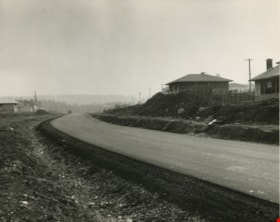
- Item is a digitized silent film segment identified as Reel 16. The film footage shows land being cleared to make way for the Digney Speedway located near the corner of Irmin Street and MacPherson Avenue, one of the men seen in this footage clearing the land is named Lucky Fordham. The film continues with footage of a press dinner in the garden of Andy Digney's home on Bonsor Avenue in Burnaby and is followed with footage of the Digney Speedway in operation for the grand opening on July 8, 1948. Midget cars and jalopies (stock cars) can be seen racing on the speedway. Some of the footage of the raceway pit and races switches to black and white.The film closes with colour footage of a truck moving Lucky Fordham's house from Bonsor Ave to the speedway.
- Subjects
- Sports - Automobile Racing
- Media Type
- Moving Images
- Photographer
- Digney, Andy
- Creator
- Digney, Andy
- Notes
- Title based on contents of film
- Geographic Access
- Bonsor Avenue
- Historic Neighbourhood
- Alta-Vista (Historic Neighbourhood)
- Central Park (Historic Neighbourhood)
- Planning Study Area
- Clinton-Glenwood Area
- Maywood Area
Images
Video
Building and opening the Digney Speedway, [between 1948 and 1949]
Building and opening the Digney Speedway, [between 1948 and 1949]
https://search.heritageburnaby.ca/media/hpo/_Data/_Archives_Moving_Images/_Unrestricted/562-003-16.m4vBurnaby Centennial '71 Committee collection
https://search.heritageburnaby.ca/link/museumdescription12986
- Repository
- Burnaby Village Museum
- Date
- 1970-1971
- Collection/Fonds
- Burnaby Centennial '71 Committee collection
- Description Level
- Fonds
- Physical Description
- 57 architectural drawings + approx. 45 cm of textual records + 94 photographs + 1 video recording (mp4) + 1 film reel
- Scope and Content
- Collection consists of records documenting the planning and development of the Burnaby Centennial '71 Committee's commemorative project, Heritage Village (Burnaby Village Museum) prior to it's opening in November 1971. These records were created and/or accumulated by various members of the Burnaby…
- Repository
- Burnaby Village Museum
- Collection/Fonds
- Burnaby Centennial '71 Committee collection
- Description Level
- Fonds
- Physical Description
- 57 architectural drawings + approx. 45 cm of textual records + 94 photographs + 1 video recording (mp4) + 1 film reel
- Scope and Content
- Collection consists of records documenting the planning and development of the Burnaby Centennial '71 Committee's commemorative project, Heritage Village (Burnaby Village Museum) prior to it's opening in November 1971. These records were created and/or accumulated by various members of the Burnaby ’71 Centennial Committee sub-committee, Heritage Village staff and the Century Park Museum Association.
- History
- The Burnaby Centennial '71 Committee was formed in accordance with the British Columbia Centennial '71 Act and was directed by the Provincial Centennial '71 Committee. In April 1970, a representative group of Burnaby citizens were appointed to the committee. Members of the committee included: Ex-Officio Mayor Robert W. Prittie; Chairman, James A. Barrrington; Vice Chairman, Gordon H. Skene; Secretary-Treasurer, Charles B. Brown; Alderman, John D. Drummond; Mrs. Joan Johnston; Mrs. Martin Dunsmuir; Miss Rose Bancroft; Msgr. J.E. Brown; Messrs. Elmer Buckingham; A.B. "Sandy" Stewart; Vic Stusiak; Fraser Wilson; Don Copan and Richard Smith. The purpose of the committee was to ensure that all Burnaby citizens as individuals, family groups or members of community organizations had an opportunity to participate and contribute to celebrations marking the 100th Anniversary of the entry of British Columbia into Confederation and further to make written suggestions of a permanent Centennial project of lasting value and significance to the community. Programs and special events sponsored by the committee included; Flag raising ceremony on January 1, 1971, New Year's Day Ceremony, parades, plays (including "Barkerville '71"), musical events, Burnaby pioneer award presentations, a horse show, lacrosse jamboree, minor baseball, volleyball, tennis, football, soccer, judo and field hockey tournaments, a swim meet, an antique car rally, Easter egg hunt, Rocketry meet, Boy Scouts outdoor action show, Girl Guides "camporee", Midsummer Festival at Burnaby Arts Centre, Rhododendrun Festival at Century Gardens, Variety show, Centennial Ball, Burnaby Rhodendrun Flower show, a Miss Burnaby Pageant, Sports Day, Burnaby Amateur Radio Club party, Centennial '71 Caravan, Centennial High School Art Contest, Sod Turning Ceremony at Heritage park Museum and opening of Heritage Village Museum in November. A sub-committee of the Centennial Committee was responsible for the development of a City of Burnaby permanent commemorative project which became Heritage Village. Sandy Stewart was the sub-committee chair who worked with Richie Smith and Vic Stusiak to develop the concept for an open- air museum reflective of a tram stop community. Architect Rudy Kovacs was hired to come up with a design for the project. Official sod-turning of Heritage Village took place on April 11, 1971. Mayor Bob Prittie officially turned the sod in front of the Elworth house before a crowd of 500. In the spring of 1971, a Heritage Village Director and Curator were hired to oversee the development of the project and acquire artifacts. Salaries were paid through the Parks Commission. The sub-committee continued to assist in overseeing the project to completion. Vic Stusiak set up an administrative structure to govern the new museum. The building of the museum was contracted by Ballarin Bros. Construction at a cost of $121,000 and work began in mid July. Trevi Construction Co. was contracted to do the finished carpentry on the project. The Century Park Museum Association was formed to govern Heritage Village with directors elected on October 26, 1971. Heritage Village officially opened on November 19, 1971 with Mayor Bob Prittie and Governor General Roland Michener in attendance. On January 27, 1972 the committee turned over the Heritage Village Project to the Corporation of the District of Burnaby. After this, the committee was dissolved and all remaining funds were transferred to the Century Park Museum Association which took over the governance of Heritage Village, later known as Burnaby Village Museum.
- Creator
- Burnaby Centennial '71 Committee
- Accession Code
- BV985.6018
- BV000.18
- BV019.52
- BV020.5
- BV022.9
- Date
- 1970-1971
- Related Material
- Century Park Museum Association fonds
- Donald Copan collection
- Burnaby Village Museum fonds
- Arrangement
- Records were accumulated and donated by various donors over time. They were arranged and described by subject and format as discrete items originating from this committee.
- Notes
- Title based on content of collection
- Some records within this collection have restricted access - contact Burnaby Village Museum for further information
- Further accruals are expected
Burnaby Heights Neighbourhood
https://search.heritageburnaby.ca/link/landmark776
- Repository
- Burnaby Heritage Planning
- Associated Dates
- 1955-2008
- Heritage Value
- Up until the 1970s, this neighbourhood was known as Vancouver Heights. When a new park was created during that decade and named "Burnaby Heights Park," the name was gradually adopted by newcomers to the area. Today, you will hear residents refer to their neighbourhood as Burnaby Heights, Vancouver Heights, or just "The Heights." Throughout the 1960s and 1970s, the commercial district in this neighbourhood continued to grow and a Retail Merchants Association was formed which later became known as the Heights Merchants Association. The neighbourhood still retains a residential neighbourhood characteristic with an increasing number of apartment buildings and multi-family units being built over the past 20 years.
- Historic Neighbourhood
- Vancouver Heights (Historic Neighbourhood)
- Planning Study Area
- Burnaby Heights Area
Images
Burnaby historical reference collection series
https://search.heritageburnaby.ca/link/museumdescription18928
- Repository
- Burnaby Village Museum
- Date
- 1950-1992, predominant 1950-1973
- Collection/Fonds
- Burnaby Village Museum Film and Video collection
- Description Level
- Series
- Physical Description
- 3 film reels + 20 videocassettes + 1 avi
- Scope and Content
- Series consists of a reference collection of films relating to the history of Burnaby. Films include CBUT News footage "Burnaby Mountain Sod Turning"; a documentary film "Cabin" about the building of a log cabin at Burnaby Village Museum; a documentary film "A Friend at the Door" about the work of …
- Repository
- Burnaby Village Museum
- Collection/Fonds
- Burnaby Village Museum Film and Video collection
- Description Level
- Series
- Physical Description
- 3 film reels + 20 videocassettes + 1 avi
- Scope and Content
- Series consists of a reference collection of films relating to the history of Burnaby. Films include CBUT News footage "Burnaby Mountain Sod Turning"; a documentary film "Cabin" about the building of a log cabin at Burnaby Village Museum; a documentary film "A Friend at the Door" about the work of rural social workers in British Columbia; historical film footage from B.C. Transit Centennial of the B.C. Electric Lower Mainland trams and home movie footage created by the Handel family.
- Accession Code
- HV971.30
- BV005.8
- BV005.48
- BV012.37
- BV014.39
- BV016.37
- BV017.11
- BV020.5
- Date
- 1950-1992, predominant 1950-1973
- Media Type
- Moving Images
- Notes
- Title based on contents of series
Burnaby Image Bank subseries
https://search.heritageburnaby.ca/link/archivedescription64462
- Repository
- City of Burnaby Archives
- Date
- [1910] (date of original) -1993
- Collection/Fonds
- Burnaby Historical Society fonds
- Description Level
- Subseries
- Physical Description
- Photographs and other material
- Scope and Content
- Subseries consists of the SFU/Burnaby Centennial Committee's Image Bank project records. Records include: Image Bank database and backups in a variety of formats; 813 photographs collected by Simon Fraser University Archives staff; eleven screened negatives from the Burnaby Image Bank that were us…
- Repository
- City of Burnaby Archives
- Date
- [1910] (date of original) -1993
- Collection/Fonds
- Burnaby Historical Society fonds
- Subseries
- Burnaby Image Bank subseries
- Physical Description
- Photographs and other material
- Description Level
- Subseries
- Access Restriction
- Open Access
- Accession Number
- BHS1999-03
- BHS2004-13
- BHS2001-15
- Scope and Content
- Subseries consists of the SFU/Burnaby Centennial Committee's Image Bank project records. Records include: Image Bank database and backups in a variety of formats; 813 photographs collected by Simon Fraser University Archives staff; eleven screened negatives from the Burnaby Image Bank that were used for the publication "Burnaby: A Cultural Inventory and Resource Guide"; and one VHS tape and DVD access copy of "Burnaby's Photographic Family Album / Burnaby Image Bank Collection / Volume 1 / 1992" which was created by the Committee for public viewing and purchase. The collection of photographs for the Image Bank project were gathered from various donors to commemorate the Centennial of the City of Burnaby. All photographs were collected from Burnaby families' personal albums by Simon Fraser University Archives staff during 1991 with a focus on the history of the people and the landscape of Burnaby. Photographs were collected from every decade for every neighbourhood in effort to describe the City's evolving ethnic, cultural and physical landscape. In March 1992, 20 of these images were selected by a jury for their aesthetic quality and displayed at the Bennett Library Gallery at Simon Fraser University for the "Images of Burnaby" exhibition. This exhibit travelled to various locations between 1992-1993 within Burnaby and Douglas College in New Westminster. The entire 800+ collection was made available for public purchase and viewing on video cassette. As well, each Burnaby school and each branch of the Burnaby Public Library received their own VHS copy for information and research purposes. The "Image Bank" video collection was buried alongside the video "Images and Voices of Burnaby" in the City of Burnaby's time capsule, mounted at City Hall in 1992.
- Media Type
- Photograph
- Textual Record
- Moving Images
- Creator
- SFU/Burnaby Centennial Committee
- Notes
- Title based on contents of subseries
- PC 370, MSS131, MSS088, MI577
Burnaby Lake Neighbourhood
https://search.heritageburnaby.ca/link/landmark700
- Repository
- Burnaby Heritage Planning
- Associated Dates
- 1925-1954
- Heritage Value
- After World War I and the Great Depression of the 1930s, more homes were constructed and subdivisions created in the Burnaby Lake district. The area around Deer Lake gained a reputation for being an "artistic development of commodious homes with park-like grounds."
- Historic Neighbourhood
- Burnaby Lake (Historic Neighbourhood)
- Planning Study Area
- Burnaby Lake Area
Images
Burnaby Lake Neighbourhood
https://search.heritageburnaby.ca/link/landmark821
- Repository
- Burnaby Heritage Planning
- Associated Dates
- 1955-2008
- Heritage Value
- In 1966 Burnaby Lake was identified as a key potential regional park in the GVRD ’s Regional Park Plan for the Lower Mainland. The lake was to be developed for nature study, strolling, trail riding, canoeing, sightseeing and picnicking. It was formally recognized as a regional nature park in 1979, at which time the GVRD assumed management of the park through a lease agreement with the City of Burnaby. In 1993 Burnaby Lake was selected by the City of Burnaby to be included in Greater Vancouver ’s Green Zone, and was identified as a key component of the GVRD ’s Park and Outdoor Recreation System (PORS) for the Burrard/Peninsula/Richmond sector, which includes Burnaby, Vancouver, New Westminster, and Richmond.
- Historic Neighbourhood
- Burnaby Lake (Historic Neighbourhood)
- Planning Study Area
- Burnaby Lake Area
Images
Burnaby Mountain Neighbourhood
https://search.heritageburnaby.ca/link/landmark792
- Repository
- Burnaby Heritage Planning
- Associated Dates
- 1955-2008
- Heritage Value
- Burnaby Mountain had been dedicated as park in 1942, however the original park boundaries were reconsidered in 1952 with the development of the Trans Mountain Pipeline. Although the boundaries were adjusted to accommodate this project, significant conservation and park lands were left untouched. When, in 1962, the government of British Columbia determined the need for additional post-secondary facilities, Burnaby Mountain was chosen as the site for the new Simon Fraser University which opened in 1965. As early as 1964, the idea of establishing a townsite around the university had been discussed by Burnaby, but it was not until the mid-1990s that the idea came to fruition and by the early 2000s, a new housing development know as the UniverCity took shape on the mountain adjacent to the university.
- Historic Neighbourhood
- Barnet (Historic Neighbourhood)
- Planning Study Area
- Burnaby Mountain Area
Images
Burnaby North High School
https://search.heritageburnaby.ca/link/landmark745
- Repository
- Burnaby Heritage Planning
- Associated Dates
- 1923-1982
- Street View URL
- Google Maps Street View
- Repository
- Burnaby Heritage Planning
- Geographic Access
- Willingdon Avenue
- Associated Dates
- 1923-1982
- Heritage Value
- Burnaby North and Burnaby South were the first high schools built in the City. Before the high school opened, Burnaby students had to travel to Vancouver if they wished to pursue education beyond an elementary level. In 1921, arrangements were made to use the basement of the Presbyterian Church for instruction of local students. By 1922 the Burnaby North High School opened at its first permanent location (4375 Pandora Street - which is now Rosser Elementary). In 1945, the Willingdon Avenue site was built and was used until a new building was constructed in 1961 on Hammarskjold Drive. From 1962, the school was used as Burnaby Heights Junior High school, but it closed in 1982 and the junior high students went to the new Burnaby North on Hammarskjold.
- Historic Neighbourhood
- Capitol Hill (Historic Neighbourhood)
- Planning Study Area
- Capitol Hill Area
- Street Address
- 250 Willingdon Avenue
- Street View URL
- Google Maps Street View
Images
Burnaby South High School
https://search.heritageburnaby.ca/link/landmark770
- Repository
- Burnaby Heritage Planning
- Associated Dates
- 1922-1988
- Street View URL
- Google Maps Street View
- Repository
- Burnaby Heritage Planning
- Geographic Access
- Southoaks Crescent
- Associated Dates
- 1922-1988
- Heritage Value
- Burnaby South and Burnaby North were Burnaby's first high schools. The first rooms of the school were built in 1922 on the same grounds as the Kingsway East Elementary School. In 1940, a two-storey building was erected and additions were made in 1963, 1967 and 1972. Kingsway East closed in 1925 and its buildings were used by the high school for Industrial Arts and Home Economics. In the early 1990s, a new "urban education centre" (Burnaby South/B.C. School for the Deaf) was opened, replacing the old Burnaby South High School.
- Historic Neighbourhood
- Edmonds (Historic Neighbourhood)
- Planning Study Area
- Kingsway-Beresford Area
- Street Address
- 6650 Southoaks Crescent
- Street View URL
- Google Maps Street View
Images
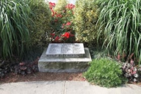
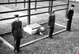
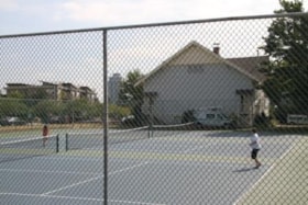
Burnaby South High School Cenotaph & Memorial Tennis Courts
https://search.heritageburnaby.ca/link/landmark547
- Repository
- Burnaby Heritage Planning
- Description
- This memorial comprises a cenotaph and three tennis courts: the former a monument of British Columbia granite inscribed with the names of fifty-one students of Burnaby South High School who lost their lives in the Second World War; and the latter a living memorial to these former students.
- Associated Dates
- 1948
- Formal Recognition
- Heritage Designation, Community Heritage Register
- Street View URL
- Google Maps Street View
- Repository
- Burnaby Heritage Planning
- Geographic Access
- Southoaks Crescent
- Associated Dates
- 1948
- Formal Recognition
- Heritage Designation, Community Heritage Register
- Enactment Type
- Bylaw No. 9807
- Enactment Date
- 23/11/1992
- Description
- This memorial comprises a cenotaph and three tennis courts: the former a monument of British Columbia granite inscribed with the names of fifty-one students of Burnaby South High School who lost their lives in the Second World War; and the latter a living memorial to these former students.
- Heritage Value
- This memorial is important for its spiritual, symbolic, and cultural associations for the former students of Burnaby South High School, and for all youth in the community. The cenotaph is of personal significance to the families of those who lost their lives. The unusual combination of cenotaph and living memorial - the tennis courts - represents a rare statement of a community's commitment to not allow the sacrifice of its youth to be forgotten by providing an active facility which draw people to the place on a regular basis rather than just on occasions of remembrance. As such it is an important symbol of a humanitarian ethic. In combination with the Kingsway East School, now rehabilitated as the Alan Emmott Centre, this memorial represents a valuable haven of green-space and recreation in the high-density urban development that now surrounds it.
- Defining Elements
- Key elements that define the heritage character of the Burnaby South High School Cenotaph & Memorial Tennis Courts include the: - location of the cenotaph adjacent to the living memorial - spatial association of this memorial and the remaining school building - physical fabric of both the granite monument and the tennis courts
- Historic Neighbourhood
- Edmonds (Historic Neighbourhood)
- Planning Study Area
- Kingsway-Beresford Area
- Function
- Primary Current--Public Feature
- Primary Historic--Public Feature
- Community
- Burnaby
- Cadastral Identifier
- P.I.D. No. 016-367-154 Legal Description: Lot 1, District Lot 96, Group 1 New Westminster District, Plan 86581
- Boundaries
- Burnaby South High School Cenotaph & Memorial Tennis Courts is comprised of a single municipally-owned property located at 6650 Southoaks Crescent, Burnaby.
- Area
- 6,070.00
- Contributing Resource
- Building
- Landscape Feature
- Structure
- Ownership
- Public (local)
- Documentation
- Heritage Site Files: PC77000 20. City of Burnaby Planning and Building Department, 4949 Canada Way, Burnaby, B.C., V5G 1M2
- Street Address
- 6650 Southoaks Crescent
- Street View URL
- Google Maps Street View






![Building and opening the Digney Speedway, [between 1948 and 1949] thumbnail](/media/Hpo/_Data/_Archives_Moving_Images/_Unrestricted/562-003-16.jpg?width=280)


