Narrow Results By
Creator
- Adams, John 2
- Armstrong, Sophie 1
- Beach, Chris 1
- Bekins Moving and Storage Company Limited 1
- Bowman, Carly 1
- British Columbia Underwriters' Association 2
- Burnett and McGugan B.C. Land Surveyors, New Westminster 5
- Burnett, David H. 1
- Burnett, Geoffrey K. 5
- Burnett & McGugan, Engineers and Surveyors 23
- City Map and White Print Co. 1
- Coast Map and Blue Print Co. 1
Person / Organization
- All Saints Anglican Church 1
- Armstrong Avenue School 1
- Barnet School 1
- Broadview Presbyterian Church 1
- Burnaby Village Museum 3
- Burnett, Geoffrey K. 2
- Ceperley, H.T. 2
- Chinese Market Gardens 1
- Douglas Road School 1
- Dundonald United Church 1
- East Burnaby United Church, 1925-2008 1
- Edmonds Community School 2
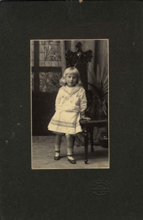
Kitty Hill
https://search.heritageburnaby.ca/link/archivedescription66567
- Repository
- City of Burnaby Archives
- Date
- 1904
- Collection/Fonds
- Peers Family and Hill Family fonds
- Description Level
- Item
- Physical Description
- 1 photograph : b&w + 1 watercolour painting
- Scope and Content
- Photograph is a portrait of Kitty Hill, posing next to a high-back chair. Accompanying the photograph is a watercolour painting that was based on this photograph, done on a linen backing.
- Repository
- City of Burnaby Archives
- Date
- 1904
- Collection/Fonds
- Peers Family and Hill Family fonds
- Physical Description
- 1 photograph : b&w + 1 watercolour painting
- Description Level
- Item
- Record No.
- 477-1181
- Access Restriction
- No restrictions
- Reproduction Restriction
- No known restrictions
- Accession Number
- 2007-12
- Scope and Content
- Photograph is a portrait of Kitty Hill, posing next to a high-back chair. Accompanying the photograph is a watercolour painting that was based on this photograph, done on a linen backing.
- Media Type
- Photograph
- Graphic Material
- Notes
- Title based on contents of photograph
Images

![California quail, [1956] thumbnail](/media/hpo/_Data/_Archives_Images/_Unrestricted/559/559-003.jpg?width=280)
California quail
https://search.heritageburnaby.ca/link/archivedescription82748
- Repository
- City of Burnaby Archives
- Date
- [1956]
- Collection/Fonds
- Hazel Simnett collection
- Description Level
- Item
- Physical Description
- 1 painting : colour print ; 37 x 28 cm
- Scope and Content
- Painting shows two California quail.
- Repository
- City of Burnaby Archives
- Date
- [1956]
- Collection/Fonds
- Hazel Simnett collection
- Physical Description
- 1 painting : colour print ; 37 x 28 cm
- Description Level
- Item
- Record No.
- 559-003
- Access Restriction
- In Archives only
- Reproduction Restriction
- No reproduction permitted
- Accession Number
- 2013-22
- Scope and Content
- Painting shows two California quail.
- Subjects
- Animals - Birds
- Arts - Paintings
- Media Type
- Graphic Material
- Creator
- Lansdowne, James Fenwick
- Notes
- Title transcribed from item
- Simnett personal papers series
Images
![California quail, [1956] thumbnail](/media/hpo/_Data/_Archives_Images/_Unrestricted/559/559-003.jpg)
![Green-winged teal, [1957] thumbnail](/media/hpo/_Data/_Archives_Images/_Unrestricted/559/559-004.jpg?width=280)
Green-winged teal
https://search.heritageburnaby.ca/link/archivedescription82749
- Repository
- City of Burnaby Archives
- Date
- [1957]
- Collection/Fonds
- Hazel Simnett collection
- Description Level
- Item
- Physical Description
- 1 painting : colour print ; 37 x 28 cm
- Scope and Content
- Painting shows two green-winged teal.
- Repository
- City of Burnaby Archives
- Date
- [1957]
- Collection/Fonds
- Hazel Simnett collection
- Physical Description
- 1 painting : colour print ; 37 x 28 cm
- Description Level
- Item
- Record No.
- 559-004
- Access Restriction
- In Archives only
- Reproduction Restriction
- No reproduction permitted
- Accession Number
- 2013-22
- Scope and Content
- Painting shows two green-winged teal.
- Subjects
- Animals - Birds
- Arts - Paintings
- Media Type
- Graphic Material
- Creator
- Lansdowne, James Fenwick
- Notes
- Title transcribed from item
- Simnett personal papers series
Images
![Green-winged teal, [1957] thumbnail](/media/hpo/_Data/_Archives_Images/_Unrestricted/559/559-004.jpg)
![Western meadowlark, [1955] thumbnail](/media/hpo/_Data/_Archives_Images/_Unrestricted/559/559-005.jpg?width=280)
Western meadowlark
https://search.heritageburnaby.ca/link/archivedescription82750
- Repository
- City of Burnaby Archives
- Date
- [1955]
- Collection/Fonds
- Hazel Simnett collection
- Description Level
- Item
- Physical Description
- 1 painting : colour print ; 37 x 28 cm
- Scope and Content
- Painting shows a Western meadowlark.
- Repository
- City of Burnaby Archives
- Date
- [1955]
- Collection/Fonds
- Hazel Simnett collection
- Physical Description
- 1 painting : colour print ; 37 x 28 cm
- Description Level
- Item
- Record No.
- 559-005
- Access Restriction
- In Archives only
- Reproduction Restriction
- No reproduction permitted
- Accession Number
- 2013-22
- Scope and Content
- Painting shows a Western meadowlark.
- Subjects
- Animals - Birds
- Arts - Paintings
- Media Type
- Graphic Material
- Creator
- Lansdowne, James Fenwick
- Notes
- Title transcribed from item
- Simnett personal papers series
Images
![Western meadowlark, [1955] thumbnail](/media/hpo/_Data/_Archives_Images/_Unrestricted/559/559-005.jpg)
![Macgillivray's warbler, [1955] thumbnail](/media/hpo/_Data/_Archives_Images/_Unrestricted/559/559-006.jpg?width=280)
Macgillivray's warbler
https://search.heritageburnaby.ca/link/archivedescription82751
- Repository
- City of Burnaby Archives
- Date
- [1955]
- Collection/Fonds
- Hazel Simnett collection
- Description Level
- Item
- Physical Description
- 1 painting : colour print ; 37 x 28 cm
- Scope and Content
- Painting shows two Macgillvray's warblers.
- Repository
- City of Burnaby Archives
- Date
- [1955]
- Collection/Fonds
- Hazel Simnett collection
- Physical Description
- 1 painting : colour print ; 37 x 28 cm
- Description Level
- Item
- Record No.
- 559-006
- Access Restriction
- In Archives only
- Reproduction Restriction
- No reproduction permitted
- Accession Number
- 2013-22
- Scope and Content
- Painting shows two Macgillvray's warblers.
- Subjects
- Animals - Birds
- Arts - Paintings
- Media Type
- Graphic Material
- Creator
- Lansdowne, James Fenwick
- Notes
- Title transcribed from item
- Simnett personal papers series
Images
![Macgillivray's warbler, [1955] thumbnail](/media/hpo/_Data/_Archives_Images/_Unrestricted/559/559-006.jpg)
![Red-winged blackbird, [1957] thumbnail](/media/hpo/_Data/_Archives_Images/_Unrestricted/559/559-007.jpg?width=280)
Red-winged blackbird
https://search.heritageburnaby.ca/link/archivedescription82752
- Repository
- City of Burnaby Archives
- Date
- [1957]
- Collection/Fonds
- Hazel Simnett collection
- Description Level
- Item
- Physical Description
- 1 painting : colour print ; 28 x 18.5 cm
- Scope and Content
- Painting shows two red-winged blackbirds.
- Repository
- City of Burnaby Archives
- Date
- [1957]
- Collection/Fonds
- Hazel Simnett collection
- Physical Description
- 1 painting : colour print ; 28 x 18.5 cm
- Description Level
- Item
- Record No.
- 559-007
- Access Restriction
- In Archives only
- Reproduction Restriction
- No reproduction permitted
- Accession Number
- 2013-22
- Scope and Content
- Painting shows two red-winged blackbirds.
- Subjects
- Animals - Birds
- Arts - Paintings
- Media Type
- Graphic Material
- Creator
- Lansdowne, James Fenwick
- Notes
- Title transcribed from item
- Simnett personal papers series
Images
![Red-winged blackbird, [1957] thumbnail](/media/hpo/_Data/_Archives_Images/_Unrestricted/559/559-007.jpg)
![Bullock's oriole, [1957] thumbnail](/media/hpo/_Data/_Archives_Images/_Unrestricted/559/559-008.jpg?width=280)
Bullock's oriole
https://search.heritageburnaby.ca/link/archivedescription82753
- Repository
- City of Burnaby Archives
- Date
- [1957]
- Collection/Fonds
- Hazel Simnett collection
- Description Level
- Item
- Physical Description
- 1 paintings : colour print ; 28 x 18.5 cm
- Scope and Content
- Painting shows two Bullock's orioles.
- Repository
- City of Burnaby Archives
- Date
- [1957]
- Collection/Fonds
- Hazel Simnett collection
- Physical Description
- 1 paintings : colour print ; 28 x 18.5 cm
- Description Level
- Item
- Record No.
- 559-008
- Access Restriction
- In Archives only
- Reproduction Restriction
- No reproduction permitted
- Accession Number
- 2013-22
- Scope and Content
- Painting shows two Bullock's orioles.
- Subjects
- Animals - Birds
- Arts - Paintings
- Media Type
- Graphic Material
- Creator
- Lansdowne, James Fenwick
- Notes
- Title transcribed from item
- Simnett personal papers series
Images
![Bullock's oriole, [1957] thumbnail](/media/hpo/_Data/_Archives_Images/_Unrestricted/559/559-008.jpg)
![Belted kingfisher, [1957] thumbnail](/media/hpo/_Data/_Archives_Images/_Unrestricted/559/559-009.jpg?width=280)
Belted kingfisher
https://search.heritageburnaby.ca/link/archivedescription82754
- Repository
- City of Burnaby Archives
- Date
- [1957]
- Collection/Fonds
- Hazel Simnett collection
- Description Level
- Item
- Physical Description
- 1 paintings : colour print ; 28 x 18.5 cm
- Scope and Content
- Painting shows a belted kingfisher.
- Repository
- City of Burnaby Archives
- Date
- [1957]
- Collection/Fonds
- Hazel Simnett collection
- Physical Description
- 1 paintings : colour print ; 28 x 18.5 cm
- Description Level
- Item
- Record No.
- 559-009
- Access Restriction
- In Archives only
- Reproduction Restriction
- No reproduction permitted
- Accession Number
- 2013-22
- Scope and Content
- Painting shows a belted kingfisher.
- Subjects
- Animals - Birds
- Arts - Paintings
- Media Type
- Graphic Material
- Creator
- Lansdowne, James Fenwick
- Notes
- Title transcribed from item
- Simnett personal papers series
Images
![Belted kingfisher, [1957] thumbnail](/media/hpo/_Data/_Archives_Images/_Unrestricted/559/559-009.jpg)
![Mourning dove, [1957] thumbnail](/media/hpo/_Data/_Archives_Images/_Unrestricted/559/559-010.jpg?width=280)
Mourning dove
https://search.heritageburnaby.ca/link/archivedescription82755
- Repository
- City of Burnaby Archives
- Date
- [1957]
- Collection/Fonds
- Hazel Simnett collection
- Description Level
- Item
- Physical Description
- 1 paintings : colour print ; 28 x 18.5 cm
- Scope and Content
- Painting shows a mourning dove.
- Repository
- City of Burnaby Archives
- Date
- [1957]
- Collection/Fonds
- Hazel Simnett collection
- Physical Description
- 1 paintings : colour print ; 28 x 18.5 cm
- Description Level
- Item
- Record No.
- 559-010
- Access Restriction
- In Archives only
- Reproduction Restriction
- No reproduction permitted
- Accession Number
- 2013-22
- Scope and Content
- Painting shows a mourning dove.
- Subjects
- Animals - Birds
- Arts - Paintings
- Media Type
- Graphic Material
- Creator
- Lansdowne, James Fenwick
- Notes
- Title transcribed from item
- Simnett personal papers series
Images
![Mourning dove, [1957] thumbnail](/media/hpo/_Data/_Archives_Images/_Unrestricted/559/559-010.jpg)
![Sparrow hawk, [1957] thumbnail](/media/hpo/_Data/_Archives_Images/_Unrestricted/559/559-011.jpg?width=280)
Sparrow hawk
https://search.heritageburnaby.ca/link/archivedescription82756
- Repository
- City of Burnaby Archives
- Date
- [1957]
- Collection/Fonds
- Hazel Simnett collection
- Description Level
- Item
- Physical Description
- 1 paintings : colour print ; 28 x 18.5 cm
- Scope and Content
- Painting shows a sparrow hawk.
- Repository
- City of Burnaby Archives
- Date
- [1957]
- Collection/Fonds
- Hazel Simnett collection
- Physical Description
- 1 paintings : colour print ; 28 x 18.5 cm
- Description Level
- Item
- Record No.
- 559-011
- Access Restriction
- In Archives only
- Reproduction Restriction
- No reproduction permitted
- Accession Number
- 2013-22
- Scope and Content
- Painting shows a sparrow hawk.
- Subjects
- Animals - Birds
- Arts - Paintings
- Media Type
- Graphic Material
- Creator
- Lansdowne, James Fenwick
- Notes
- Title transcribed from item
- Simnett personal papers series
Images
![Sparrow hawk, [1957] thumbnail](/media/hpo/_Data/_Archives_Images/_Unrestricted/559/559-011.jpg)
![Planning Map of Chinese Market Gardens on Marine Drive, [between 1950 and 1959] (date of original), 2017 (date of duplication) thumbnail](/media/hpo/_Data/_BVM_Images/2017/2017_0040_0002_001.jpg?width=280)
Planning Map of Chinese Market Gardens on Marine Drive
https://search.heritageburnaby.ca/link/museumdescription4297
- Repository
- Burnaby Village Museum
- Date
- [between 1950 and 1959] (date of original), 2017 (date of duplication)
- Collection/Fonds
- Herbert Yee Law family fonds
- Description Level
- Item
- Physical Description
- 1 photograph (tiff) : col. ; 300 dpi
- Scope and Content
- Scanned copy of a survey plan of district lots 163, 162, 157, 158, and 165, near the Chinese Market Gardens along Marine Drive.
- Repository
- Burnaby Village Museum
- Collection/Fonds
- Herbert Yee Law family fonds
- Description Level
- Item
- Physical Description
- 1 photograph (tiff) : col. ; 300 dpi
- Scope and Content
- Scanned copy of a survey plan of district lots 163, 162, 157, 158, and 165, near the Chinese Market Gardens along Marine Drive.
- History
- Survey plan of district lots 163, 162, 157, 158, and 165, which is primarily the area farmed by Chinese and Chinese-Canadian market gardeners around Marine Drive between Royal Oak and Mandeville (present-day Nelson). Two Chinese/Chinese Canadian land owners can be seen on the map: N.G. Wah Sing (or Ng Wah Sing) and Yee Law (or Herbert Law).
- Geographic Access
- Marine Drive
- Accession Code
- BV017.40.2
- Access Restriction
- No restrictions
- Reproduction Restriction
- No known restrictions
- Date
- [between 1950 and 1959] (date of original), 2017 (date of duplication)
- Media Type
- Cartographic Material
- Historic Neighbourhood
- Fraser Arm (Historic Neighbourhood)
- Planning Study Area
- Big Bend Area
- Scan Resolution
- 300
- Scan Date
- 11/19/2017
- Scale
- 100
- Notes
- Title based on contents of copy scan of map
- Herbert Yee Law was donor's father and this map may have originally been his copy of the city planning/engineering documents.
Images
![Planning Map of Chinese Market Gardens on Marine Drive, [between 1950 and 1959] (date of original), 2017 (date of duplication) thumbnail](/media/hpo/_Data/_BVM_Images/2017/2017_0040_0002_001.jpg)
![Bird's eye view of New Westminster, Burnaby and Vancouver, [ca. 1911] thumbnail](/media/hpo/_Data/_BVM_Cartographic_Material/1983/1983_0012_0001_002%20Web.jpg?width=280)
Bird's eye view of New Westminster, Burnaby and Vancouver
https://search.heritageburnaby.ca/link/museumdescription8199
- Repository
- Burnaby Village Museum
- Date
- [ca. 1911]
- Collection/Fonds
- Burnaby Village Museum Map collection
- Description Level
- Item
- Physical Description
- 1 map : hand painted ; 65.5 x 99 cm
- Scope and Content
- An untitled monochromatic grayscale map of a developer's bird's eye view looking north west from Burnaby Mountain. View includes Burnaby, New Westminster, Vancouver with the North shore in the distance. Burnaby neighbourhood subdivisions of "Burnaby Heights" and "Buena Vista" are featured near the…
- Repository
- Burnaby Village Museum
- Collection/Fonds
- Burnaby Village Museum Map collection
- Description Level
- Item
- Physical Description
- 1 map : hand painted ; 65.5 x 99 cm
- Scope and Content
- An untitled monochromatic grayscale map of a developer's bird's eye view looking north west from Burnaby Mountain. View includes Burnaby, New Westminster, Vancouver with the North shore in the distance. Burnaby neighbourhood subdivisions of "Burnaby Heights" and "Buena Vista" are featured near the centre of the map. These neighbourhood subdivisions were marketed by Real Estate Agents Liebly & Blumer in 1911. Roads, buildings, factories, railways and bridges are identified on the map.
- Subjects
- Businesses - Real Estate Agencies
- Responsibility
- Leibly & Blumer Realty Co. Incorporated
- Accession Code
- HV983.12.1
- Access Restriction
- No restrictions
- Reproduction Restriction
- No known restrictions
- Date
- [ca. 1911]
- Media Type
- Cartographic Material
- Historic Neighbourhood
- East Burnaby (Historic Neighbourhood)
- Vancouver Heights (Historic Neighbourhood)
- Planning Study Area
- Cariboo-Armstrong Area
- Burnaby Heights Area
- Scan Resolution
- 300
- Scan Date
- December 2020
- Scale
- 100
- Notes
- Title based on contents of map
- Note in pencil on verso of photograph reads: "Make tint block of Buena Vista / Blocks only as shown in lots"
Zoomable Images
![Bird's eye view of New Westminster, Burnaby and Vancouver, [ca. 1911] thumbnail](/media/hpo/_Data/_BVM_Cartographic_Material/1983/1983_0012_0001_001_seadragon/1983_0012_0001_001.jpg?w=280)

Map of Municipality of Burnaby
https://search.heritageburnaby.ca/link/museumdescription8200
- Repository
- Burnaby Village Museum
- Date
- 1921
- Collection/Fonds
- Burnaby Village Museum Map collection
- Description Level
- Item
- Physical Description
- 1 map : lithographic print, b&w ; 83 x 56 cm
- Scope and Content
- Item consists of a map of the Municipality of Burnaby compiled and published by Dominion Blueprint & Map Company.
- Repository
- Burnaby Village Museum
- Collection/Fonds
- Burnaby Village Museum Map collection
- Description Level
- Item
- Physical Description
- 1 map : lithographic print, b&w ; 83 x 56 cm
- Material Details
- Scale : 1:24,000 inches
- Scope and Content
- Item consists of a map of the Municipality of Burnaby compiled and published by Dominion Blueprint & Map Company.
- Creator
- Dominion Map and Blueprint Co.
- Publisher
- Blue Printers, Map Publishers and Draughtsmen
- Accession Code
- HV976.11.1
- Access Restriction
- No restrictions
- Reproduction Restriction
- No known restrictions
- Date
- 1921
- Media Type
- Cartographic Material
- Scan Resolution
- 340
- Scan Date
- 22 Dec. 2020
- Scale
- 100
- Notes
- Title based on contents of map
- Cardstock map cover reads: "Map / of the / Municipality of / Burnaby / Published by / Dominion Map & Blue Print Co. / Arts and Crafts Bldg /576 Seymour St., Vancouver, B.C. / Blue Printers, Map Publishers and Draughtsmen / Phone Sey 4670 / Price, 50 c."
- Title on map reads: "Burnaby / Municipality."
Zoomable Images

![Indexed map of Greater Vancouver, [193-] thumbnail](/media/hpo/_Data/_BVM_Cartographic_Material/1976/1976_0026_0001_001.jpg?width=280)
Indexed map of Greater Vancouver
https://search.heritageburnaby.ca/link/museumdescription8201
- Repository
- Burnaby Village Museum
- Date
- [193-]
- Collection/Fonds
- Burnaby Village Museum Map collection
- Description Level
- Item
- Physical Description
- 1 map + 1 p. textual records : b&w lithographic print on 1 sheet ; 46 x 41 cm folded to 23 x 10 cm
- Scope and Content
- Item consists of a promotional brochure for Bekins Moving and Storage, with an indexed map of Greater Vancouver showing distances from the Bekins building located at Pender Street and Beatty Street on one side, and text and images advertising the company's services and facilities on the other side.…
- Repository
- Burnaby Village Museum
- Collection/Fonds
- Burnaby Village Museum Map collection
- Description Level
- Item
- Physical Description
- 1 map + 1 p. textual records : b&w lithographic print on 1 sheet ; 46 x 41 cm folded to 23 x 10 cm
- Material Details
- Scale not defined
- Printing on two sides of sheet
- Folded into eight sections
- Scope and Content
- Item consists of a promotional brochure for Bekins Moving and Storage, with an indexed map of Greater Vancouver showing distances from the Bekins building located at Pender Street and Beatty Street on one side, and text and images advertising the company's services and facilities on the other side. Cover of folded map reads "Indexed Map of Greater Vancouver / The Great Northwest for Opportunity / Compliments of / Bekins Moving and / Storage Co.".
- Responsibility
- Bekins Moving and Storage Company Limited
- Accession Code
- HV976.26.1
- Access Restriction
- No restrictions
- Reproduction Restriction
- No known restrictions
- Date
- [193-]
- Media Type
- Cartographic Material
- Textual Record
- Scan Resolution
- 600
- Scan Date
- 2023-08-17
- Notes
- Title based on contents of map
Zoomable Images
![Indexed map of Greater Vancouver, [193-] thumbnail](/media/hpo/_Data/_BVM_Cartographic_Material/1976/1976_0026_0001_001_seadragon/1976_0026_0001_001.jpg?w=280)
![Indexed guide map of the City of Vancouver and suburbs, [1920] thumbnail](/media/hpo/_Data/_BVM_Cartographic_Material/1975/1975_0061_0013_001.jpg?width=280)
Indexed guide map of the City of Vancouver and suburbs
https://search.heritageburnaby.ca/link/museumdescription8678
- Repository
- Burnaby Village Museum
- Date
- [1920]
- Collection/Fonds
- Burnaby Village Museum Map collection
- Description Level
- Item
- Physical Description
- 1 map + textual record : col. lithographic print on paper ; 51.5 x 71 cm folded to 21 x 10 cm
- Scope and Content
- Item consists of a fold out map entitled "Indexed Guide Map of Vancouver and Suburbs" with index. Map includes concentric circles raditating out from Vancouver City Hall on corner of Hastings Street and Main Street; electric railways are indicated by heavy red lines in centres of streets. Includes …
- Repository
- Burnaby Village Museum
- Collection/Fonds
- Burnaby Village Museum Map collection
- Description Level
- Item
- Physical Description
- 1 map + textual record : col. lithographic print on paper ; 51.5 x 71 cm folded to 21 x 10 cm
- Material Details
- Scale [1:47520]
- Index on 4 pages within cardstock cover with advertisements on verso
- Scope and Content
- Item consists of a fold out map entitled "Indexed Guide Map of Vancouver and Suburbs" with index. Map includes concentric circles raditating out from Vancouver City Hall on corner of Hastings Street and Main Street; electric railways are indicated by heavy red lines in centres of streets. Includes old and new street names. Index includes a District Lot Index and Street Index.
- Publisher
- Vancouver Map and Blue Print Company
- Accession Code
- HV975.61.13
- Access Restriction
- No restrictions
- Reproduction Restriction
- No known restrictions
- Date
- [1920]
- Media Type
- Cartographic Material
- Textual Record
- Publisher Series
- 6th edition revised June 1920
- Scan Resolution
- 600
- Scan Date
- 2023-11-10
- Notes
- Title based on contents of map
- Cover of booklet reads: "INDEXED / Guide Map / of the CITY of / VANCOUVER / and / SUBURBS / Compiled and Published by / The Vancouver Map & Blue Print Co. / ...."INTERNATIONAL / BOOK SHOP / Cor. Columbia and Hastings Sts._Vancouver, B.C.".
Documents
Zoomable Images
![Indexed guide map of the City of Vancouver and suburbs, [1920] thumbnail](/media/hpo/_Data/_BVM_Cartographic_Material/1975/1975_0061_0013_002_seadragon/1975_0061_0013_002.jpg?w=280)

Map of South Western Part of British Columbia
https://search.heritageburnaby.ca/link/museumdescription8688
- Repository
- Burnaby Village Museum
- Date
- 1897
- Collection/Fonds
- Burnaby Village Museum Map collection
- Description Level
- Item
- Physical Description
- 1 map : col. ink on paper ; 68 x 88 cm
- Scope and Content
- Item consists of a "MAP OF THE SOUTH-WESTERN PART OF BRITISH COLUMBIA”. Map identifies geographic land districts of New Westminster District; Coast District; Lillooet District; Yale District, Kamloops Division, Yale Division and districts on Vancouver Island. Map also includes the northern portions…
- Repository
- Burnaby Village Museum
- Collection/Fonds
- Burnaby Village Museum Map collection
- Description Level
- Item
- Physical Description
- 1 map : col. ink on paper ; 68 x 88 cm
- Material Details
- Scale [1:633600]
- Scope and Content
- Item consists of a "MAP OF THE SOUTH-WESTERN PART OF BRITISH COLUMBIA”. Map identifies geographic land districts of New Westminster District; Coast District; Lillooet District; Yale District, Kamloops Division, Yale Division and districts on Vancouver Island. Map also includes the northern portions of the State of Washington below the 49th parallel.
- Publisher
- The Colonist Litho Victoria B.C.
- Responsibility
- Martin, George Bohun
- Accession Code
- BV993.12.12
- Access Restriction
- No restrictions
- Reproduction Restriction
- No known restrictions
- Date
- 1897
- Media Type
- Cartographic Material
- Scan Resolution
- 600
- Scan Date
- 2023-08-17
- Notes
- Transcribed title
- Scale equals 1 inch to 10 miles
- "Compiled and drawn by direction of the Honouable G.B. Martin, Chief Commissioner of Lands and Works, Victoria, B.C."
- Signed by Surveyor General "Tom Kains"
Zoomable Images


Indexed guide map of the city of Vancouver and Suburbs
https://search.heritageburnaby.ca/link/museumdescription8694
- Repository
- Burnaby Village Museum
- Date
- 1914
- Collection/Fonds
- Burnaby Village Museum Map collection
- Description Level
- Item
- Physical Description
- 1 map + textual record : col. lithographic print on paper ; 55 x 78 cm on sheet 58.5 x 82 cm folded to 20 x 10 cm
- Scope and Content
- Item consists of a map "Indexed Guide Map of the City of Vancouver and Suburbs compiled and published by The Vancouver Map and Blueprint Co. Ltd. Map shows district lots, blocks and boundaries between City of Vancouver, Point Grey, South Vancouver, Burnaby, New Westminster and parts of Richmond, No…
- Repository
- Burnaby Village Museum
- Collection/Fonds
- Burnaby Village Museum Map collection
- Description Level
- Item
- Physical Description
- 1 map + textual record : col. lithographic print on paper ; 55 x 78 cm on sheet 58.5 x 82 cm folded to 20 x 10 cm
- Material Details
- Scale not defined
- Map is folded into booklet form
- Scope and Content
- Item consists of a map "Indexed Guide Map of the City of Vancouver and Suburbs compiled and published by The Vancouver Map and Blueprint Co. Ltd. Map shows district lots, blocks and boundaries between City of Vancouver, Point Grey, South Vancouver, Burnaby, New Westminster and parts of Richmond, North Vancouver and West Vancouver. Concentric cirlces indicate the distance in miles from the intersection of Main Street and Hastings Street, Vancouver in intervals of 1/2 mile. Map is folded into booklet form and includes a four page index with cardstock cover. Index page 1 is titled "Hotels"; page 2 is titled "District Lot Index"; pages 3-8 "Street Index".
- Publisher
- Vancouver Map and Blueprint Company Limited
- Edition
- 5th Edition revised to June 1914
- Geographic Access
- Vancouver
- Accession Code
- HV983.9.18
- Date
- 1914
- Media Type
- Cartographic Material
- Scan Resolution
- 600
- Scan Date
- 2023-08-17
- Notes
- Transcribed title from map and cover
- Sticker adhered to front cover of index of two lions "Service / "WE GIVE IT" / WESTERN SPECIALTY / LIMITED/ STATIONERS AND PRINTERS / VANCOUVER - B.C."
Documents
Zoomable Images

![Map of location of Toishan Middle school, [between 1919 and 1926] thumbnail](/media/hpo/_Data/_BVM_Cartographic_Material/1985/1985_5331_0009_002%20Web.jpg?width=280)
Map of location of Toishan Middle school
https://search.heritageburnaby.ca/link/museumdescription8695
- Repository
- Burnaby Village Museum
- Date
- [between 1919 and 1926]
- Collection/Fonds
- Way Sang Yuen Wat Kee & Co. fonds
- Description Level
- Item
- Physical Description
- 1 map : blueprint ink on paper ; 41.5 x 25.5 cm
- Scope and Content
- Item consists of a topographic map with Chinese characters indicating the location of where the Toishan Middle school will be constructed. Overseas Chinese who originated from Toishan county in China participated in the fundraising efforts for the first phase of building this school (there were thr…
- Repository
- Burnaby Village Museum
- Collection/Fonds
- Way Sang Yuen Wat Kee & Co. fonds
- Description Level
- Item
- Physical Description
- 1 map : blueprint ink on paper ; 41.5 x 25.5 cm
- Material Details
- Map details include elevation contours, marsh, roads, water and rail
- Scope and Content
- Item consists of a topographic map with Chinese characters indicating the location of where the Toishan Middle school will be constructed. Overseas Chinese who originated from Toishan county in China participated in the fundraising efforts for the first phase of building this school (there were three phases in total). The block of text on the bottom right describes the geographical location of the school. It also mentions some of the amenities that they want to add to the school grounds, which requires additional funding.
- Subjects
- Buildings - Schools
- Accession Code
- BV985.5331.9
- Access Restriction
- No restrictions
- Reproduction Restriction
- No known restrictions
- Date
- [between 1919 and 1926]
- Media Type
- Cartographic Material
- Scan Resolution
- 300
- Scan Date
- December 2020
- Scale
- 100
- Notes
- Title based on contents of map
Images
![Map of location of Toishan Middle school, [between 1919 and 1926] thumbnail](/media/hpo/_Data/_BVM_Cartographic_Material/1985/1985_5331_0009_002%20Web.jpg)
![Sectional map and street directory of Vancouver : Dial map of greater Vancouver including adjacent municipalities, [ca. 1950] thumbnail](/media/hpo/_Data/_BVM_Cartographic_Material/2000/2000_0003_0011_001%20WEB.jpg?width=280)
Sectional map and street directory of Vancouver : Dial map of greater Vancouver including adjacent municipalities
https://search.heritageburnaby.ca/link/museumdescription8697
- Repository
- Burnaby Village Museum
- Date
- [ca. 1950]
- Collection/Fonds
- Burnaby Village Museum Map collection
- Description Level
- Item
- Physical Description
- 2 maps and 1 p. of textual records on 1 sheet : lithographic prints, col. ; 55.5 x 75 cm + 2 dials and 25 x 72 cm + directory on sheet 55.5 x 75 cm, folded to 28.5 x 12.5 cm
- Scope and Content
- Item is a sectional map and street directory titled "Dial Map of Greater Vancouver and adjacent Municipalities" with a map on one side titled "Dial Map of Greater Vancouver and Suburbs" including Vancouver, West Vancouver, North Vancouver and Burnaby and includes street car and bus lines, railways,…
- Repository
- Burnaby Village Museum
- Collection/Fonds
- Burnaby Village Museum Map collection
- Description Level
- Item
- Physical Description
- 2 maps and 1 p. of textual records on 1 sheet : lithographic prints, col. ; 55.5 x 75 cm + 2 dials and 25 x 72 cm + directory on sheet 55.5 x 75 cm, folded to 28.5 x 12.5 cm
- Material Details
- Scales 1:42240, 1:144823
- 2 alphabetic dials on narrow strips of paper attached to map by grommets
- Scope and Content
- Item is a sectional map and street directory titled "Dial Map of Greater Vancouver and adjacent Municipalities" with a map on one side titled "Dial Map of Greater Vancouver and Suburbs" including Vancouver, West Vancouver, North Vancouver and Burnaby and includes street car and bus lines, railways, hospitals, parks, block nos. and street indexes with two alphabetic dials, one for Vancouver, the other for New Westminster. The other side of the map includes a map of "Fraser Valley" along with a directory of Vancouver street car and bus routes, business blocks, public buildings, hospitals, bathing beaches, locations of Vancouver fire halls and Vancouver city schools.
- Creator
- Dominion Map and Blueprint Co.
- Publisher
- Sectional Map and Street Directory Company
- Geographic Access
- Vancouver
- Accession Code
- BV000.3.11
- Access Restriction
- No restrictions
- Reproduction Restriction
- No known restrictions
- Date
- [ca. 1950]
- Media Type
- Cartographic Material
- Scan Resolution
- 380
- Scan Date
- 22-Dec-2020
- Scale
- 100
- Notes
- Title based on contents of map
Images
![Sectional map and street directory of Vancouver : Dial map of greater Vancouver including adjacent municipalities, [ca. 1950] thumbnail](/media/hpo/_Data/_BVM_Cartographic_Material/2000/2000_0003_0011_001%20WEB.jpg)


![Municipality of Burnaby, [between 1910 and 1930] thumbnail](/media/hpo/_Data/_BVM_Cartographic_Material/2008/2008_0024_0001_002.jpg?width=280)
Municipality of Burnaby
https://search.heritageburnaby.ca/link/museumdescription8702
- Repository
- Burnaby Village Museum
- Date
- [between 1910 and 1930]
- Collection/Fonds
- Burnaby Village Museum Map collection
- Description Level
- Item
- Physical Description
- 1 map : blackline print with col. ; 83 x 53 cm on sheet 92 x 61 cm
- Scope and Content
- Item consists of "Municipality of Burnaby" map outlining waterlines, telephone lines, lights and power lines, and street lights. A section of the upper left corner (borded by Boundary Road to the west; Queens Ave to the east; Burrard Inlet to the north and Parker Avenue to the south) of map is han…
- Repository
- Burnaby Village Museum
- Collection/Fonds
- Burnaby Village Museum Map collection
- Description Level
- Item
- Physical Description
- 1 map : blackline print with col. ; 83 x 53 cm on sheet 92 x 61 cm
- Material Details
- Scale 10 chains = 1 inch
- Scope and Content
- Item consists of "Municipality of Burnaby" map outlining waterlines, telephone lines, lights and power lines, and street lights. A section of the upper left corner (borded by Boundary Road to the west; Queens Ave to the east; Burrard Inlet to the north and Parker Avenue to the south) of map is hand coloured in red with "Queens Avenue" and "Parker Avenue" identified.
- Creator
- Coast Map and Blue Print Co.
- Responsibility
- Municipal Council of Burnaby
- Accession Code
- BV008.24.1
- Access Restriction
- No restrictions
- Reproduction Restriction
- No known restrictions
- Date
- [between 1910 and 1930]
- Media Type
- Cartographic Material
- Scan Resolution
- 300
- Scan Date
- 2022-05-10
- Notes
- Transcribed title
- "COMPILED EXPRESSLY FOR / THE MUNICIPAL COUNCIL OF BURNABY/ BY/ THE COAST MAP AND BLUE PRINT CO/ EMPIRE BLDG VANCOUVER B.C."
Images
![Municipality of Burnaby, [between 1910 and 1930] thumbnail](/media/hpo/_Data/_BVM_Cartographic_Material/2008/2008_0024_0001_002.jpg)