Narrow Results By
Format
- Architectural Drawing 240
- Book 898
- Bylaws - Adopted 2775
- Bylaws - Other 7
- Bylaws - Repealed 343
- Cartographic Material 113
- Catalogue 1
- Council - Committee Report 3473
- Council - Manager's Report 6979
- Council - Mayor/Councillor/Staff Report 9014
- Council - Public Hearing Minutes 160
- Council - Regular Council Minutes 1697
Decade
- 2020s 2390
- 2010s 6268
- 2000s 9728
- 1990s 13495
- 1980s
- 1970s 18312
- 1960s 12800
- 1950s
- 1940s
- 1930s 7925
- 1920s 12034
- 1910s 8842
- 1900s
- 1890s 1860
- 1880s 298
- 1870s 125
- 1860s 176
- 1850s 45
- 1840s 24
- 1830s 14
- 1820s 11
- 1810s 8
- 1800s 11
- 1790s 6
- 1780s 5
- 1770s 5
- 1760s 5
- 1750s 5
- 1740s 5
- 1730s 5
- 1720s 5
- 1710s 7
- 1700s 6
- 1690s 5
- 1680s 6
- 1670s 4
- 1660s 4
- 1650s 4
- 1640s 4
- 1630s 4
- 1620s 4
- 1610s 4
- 1600s 4
- 1590s 1
- 1580s 1
- 1570s 1
- 1560s 1
- 1550s 1
- 1540s 1
- 1530s 1
- 1520s 2
- 1510s 1
- 1500s 1
- 1490s 1
- 1480s 1
Subject
- Accidents 1
- Accidents - Automobile Accidents 4
- Accidents - Train Accidents 6
- Adornment - Jewelry 2
- Advertising Medium 6
- Advertising Medium - Signs and Signboards 30
- Aerial Photographs 26
- Agricultural Tools and Equipment 16
- Agricultural Tools and Equipment - Cultivators 2
- Agricultural Tools and Equipment - Gardening Equipment 2
- Agricultural Tools and Equipment - Plows 1
- Agricultural Tools and Equipment - Tractors 1
Creator
- Ackerknecht, Erwin H. (Erwin Heinz), 1906-1988 1
- Adair, Neal G. 3
- Adams, Edith 5
- Adams, George Burton, 1851-1925 1
- Adams, J. 1
- Adams, Peter 1
- Adams, W.H. Davenport (William Henry Davenport), 1828-1891 1
- Adkins, H. E. (Hector Ernest), 1885-1962 1
- Aero Surveys Limited 2
- Alberta. Alberta Culture 1
- Aldwinckle, Eric 1
- Alexander, Charles M. (Charles McCallon), 1867-1920 1
![Two unidentified girls, [1860-1900] thumbnail](/media/hpo/_Data/_Archives_Images/_Unrestricted/550/550-018.jpg?width=280)
Two unidentified girls
https://search.heritageburnaby.ca/link/archivedescription82356
- Repository
- City of Burnaby Archives
- Date
- [1860-1900]
- Collection/Fonds
- Hill family and Vidal family fonds
- Description Level
- Item
- Physical Description
- 1 photograph : sepia ; 4 x 6 cm
- Scope and Content
- Photograph is a portrait of two unidentified girls, one perhaps being Blanche Wilkinson.
- Repository
- City of Burnaby Archives
- Date
- [1860-1900]
- Collection/Fonds
- Hill family and Vidal family fonds
- Physical Description
- 1 photograph : sepia ; 4 x 6 cm
- Description Level
- Item
- Record No.
- 550-018
- Access Restriction
- No restrictions
- Reproduction Restriction
- No known restrictions
- Accession Number
- 2013-03
- Scope and Content
- Photograph is a portrait of two unidentified girls, one perhaps being Blanche Wilkinson.
- Subjects
- Persons - Children
- Media Type
- Photograph
- Notes
- Title based on contents of photograph
- Note in pencil on album page reads: "? and Blanche W.?"
- Photograph stamp on verso reads: "Barron & Walker / Artist and Photographer / B & W"
Images
![Two unidentified girls, [1860-1900] thumbnail](/media/hpo/_Data/_Archives_Images/_Unrestricted/550/550-018.jpg)
![Unidentified man, [1860-1900] thumbnail](/media/hpo/_Data/_Archives_Images/_Unrestricted/550/550-019.jpg?width=280)
Unidentified man
https://search.heritageburnaby.ca/link/archivedescription82357
- Repository
- City of Burnaby Archives
- Date
- [1860-1900]
- Collection/Fonds
- Hill family and Vidal family fonds
- Description Level
- Item
- Physical Description
- 1 photograph : b&w ; 5 x 4.5 cm + 1 accompanying page
- Scope and Content
- Photograph is a portrait of an unidentified man.
- Repository
- City of Burnaby Archives
- Date
- [1860-1900]
- Collection/Fonds
- Hill family and Vidal family fonds
- Physical Description
- 1 photograph : b&w ; 5 x 4.5 cm + 1 accompanying page
- Description Level
- Item
- Record No.
- 550-019
- Access Restriction
- No restrictions
- Reproduction Restriction
- No known restrictions
- Accession Number
- 2013-03
- Scope and Content
- Photograph is a portrait of an unidentified man.
- Media Type
- Photograph
- Notes
- Title based on contents of photograph
- Note in pencil on album page reads: "Unknown"
Images
![Unidentified man, [1860-1900] thumbnail](/media/hpo/_Data/_Archives_Images/_Unrestricted/550/550-019.jpg)
![Maude, [1860-1900] thumbnail](/media/hpo/_Data/_Archives_Images/_Unrestricted/550/550-023.jpg?width=280)
Maude
https://search.heritageburnaby.ca/link/archivedescription82373
- Repository
- City of Burnaby Archives
- Date
- [1860-1900]
- Collection/Fonds
- Hill family and Vidal family fonds
- Description Level
- Item
- Physical Description
- 1 photograph : sepia ; 10 x 6 cm
- Scope and Content
- Photograph is a portrait of Maude.
- Repository
- City of Burnaby Archives
- Date
- [1860-1900]
- Collection/Fonds
- Hill family and Vidal family fonds
- Physical Description
- 1 photograph : sepia ; 10 x 6 cm
- Description Level
- Item
- Record No.
- 550-023
- Access Restriction
- No restrictions
- Reproduction Restriction
- No known restrictions
- Accession Number
- 2013-03
- Scope and Content
- Photograph is a portrait of Maude.
- Media Type
- Photograph
- Notes
- Title based on caption accompanying photograph
- Note in pencil on album page reads: "Maude ?"
- Note in blue ink on verso reads: "Maude"
- Photograph stamp on verso reads: "J. Foster Elliott, / Photographer, / Sarnia. / Negatives Preserved"
Images
![Maude, [1860-1900] thumbnail](/media/hpo/_Data/_Archives_Images/_Unrestricted/550/550-023.jpg)
![Guy, [1860-1900] thumbnail](/media/hpo/_Data/_Archives_Images/_Unrestricted/550/550-025.jpg?width=280)
Guy
https://search.heritageburnaby.ca/link/archivedescription82376
- Repository
- City of Burnaby Archives
- Date
- [1860-1900]
- Collection/Fonds
- Hill family and Vidal family fonds
- Description Level
- Item
- Physical Description
- 1 photograph : sepia ; 10 x 6.5 cm
- Scope and Content
- Photograph is a portrait of a boy identified as Guy.
- Repository
- City of Burnaby Archives
- Date
- [1860-1900]
- Collection/Fonds
- Hill family and Vidal family fonds
- Physical Description
- 1 photograph : sepia ; 10 x 6.5 cm
- Description Level
- Item
- Record No.
- 550-025
- Access Restriction
- No restrictions
- Reproduction Restriction
- No known restrictions
- Accession Number
- 2013-03
- Scope and Content
- Photograph is a portrait of a boy identified as Guy.
- Media Type
- Photograph
- Notes
- Title based on caption accompanying photograph
- Note in pencil on album page photograph reads: "Guy ?"
- Note in blue pen on verso reads: "Guy"
- Photograph stamp on verso reads: "J. Foster Elliot / Photographer, / Sarnia. / Negatives Preserved"
Images
![Guy, [1860-1900] thumbnail](/media/hpo/_Data/_Archives_Images/_Unrestricted/550/550-025.jpg)
![Jane Ann Rollason, [1860-1900] thumbnail](/media/hpo/_Data/_Archives_Images/_Unrestricted/550/550-118.jpg?width=280)
Jane Ann Rollason
https://search.heritageburnaby.ca/link/archivedescription82544
- Repository
- City of Burnaby Archives
- Date
- [1860-1900]
- Collection/Fonds
- Hill family and Vidal family fonds
- Description Level
- Item
- Physical Description
- 1 photograph : sepia ; 9.5 x 6 cm + 1 piece of wood
- Scope and Content
- Photograph is a portrait of a woman identified as Jane Ann Rollason.
- Repository
- City of Burnaby Archives
- Date
- [1860-1900]
- Collection/Fonds
- Hill family and Vidal family fonds
- Physical Description
- 1 photograph : sepia ; 9.5 x 6 cm + 1 piece of wood
- Description Level
- Item
- Record No.
- 550-118
- Access Restriction
- No restrictions
- Reproduction Restriction
- No known restrictions
- Accession Number
- 2013-03
- Scope and Content
- Photograph is a portrait of a woman identified as Jane Ann Rollason.
- Media Type
- Photograph
- Notes
- Title based on note accompanying photograph
- Note in pencil on album page reads: "Jane Ann Rollinson / (wife of Richard Hill) / (Grandmother of Minard Hill)
- Note in pencil on verso reads: "Jane Ann nee Rollison (Hill)"
- Photograph stamp on verso reads: "From the Photographic Studio W Sherwoood, / 23 Nook Street, Workincton, / This or ... can be enlar... in oil or water colours. / Negatives ... always be had"
- Note in blue pen on piece of wood taped to the album page reads: "Mother of K Claude Hill B R Hill / Jane Hill Nee Rolston / Grand Mother of K M Peers"
Images
![Jane Ann Rollason, [1860-1900] thumbnail](/media/hpo/_Data/_Archives_Images/_Unrestricted/550/550-118.jpg)
![Jane Ann Rollason, [1860-1900] thumbnail](/media/hpo/_Data/_Archives_Images/_Unrestricted/550/550-119.jpg?width=280)
Jane Ann Rollason
https://search.heritageburnaby.ca/link/archivedescription82545
- Repository
- City of Burnaby Archives
- Date
- [1860-1900]
- Collection/Fonds
- Hill family and Vidal family fonds
- Description Level
- Item
- Physical Description
- 1 photograph : sepia ; 9.5 x 6 cm
- Scope and Content
- Photograph is a portrait of a woman identified as Jane Ann Rollason.
- Repository
- City of Burnaby Archives
- Date
- [1860-1900]
- Collection/Fonds
- Hill family and Vidal family fonds
- Physical Description
- 1 photograph : sepia ; 9.5 x 6 cm
- Description Level
- Item
- Record No.
- 550-119
- Access Restriction
- No restrictions
- Reproduction Restriction
- No known restrictions
- Accession Number
- 2013-03
- Scope and Content
- Photograph is a portrait of a woman identified as Jane Ann Rollason.
- Media Type
- Photograph
- Notes
- Title based on note accompanying photograph
- Note in pencil on album page reads: "____ Berkeley / (Marian (Berkeley) Hill's mother)"
- Photograph stamp on recto reads: "William Heath / 24 George Street / Plymouth"
Images
![Jane Ann Rollason, [1860-1900] thumbnail](/media/hpo/_Data/_Archives_Images/_Unrestricted/550/550-119.jpg)
![Burton family home, [1945]. Item no. 216-002 thumbnail](/media/hpo/_Data/_Archives_Images/_Unrestricted/205/216-002.jpg?width=280)
Interview with John Burton by Lynda Maeve Orr - Track 5
https://search.heritageburnaby.ca/link/oralhistory221
- Repository
- City of Burnaby Archives
- Date Range
- 1860-1932
- Length
- 0:08:48
- Summary
- This portion of the interview pertains to John Burton's description of the Linotype machine, as well as the history of his grandfather, John Foley, founder of the Orangeville Sun newspaper.
- Repository
- City of Burnaby Archives
- Summary
- This portion of the interview pertains to John Burton's description of the Linotype machine, as well as the history of his grandfather, John Foley, founder of the Orangeville Sun newspaper.
- Date Range
- 1860-1932
- Photo Info
- Burton family home, [1945]. Item no. 216-002
- Length
- 0:08:48
- Names
- Foley, John
- Scope and Content
- Recording is of an interview with John Burton at his residence in Surrey by Lynda Mauve Orr, August 24, 1989. This interview focuses on the history of newspaper and printing presses in Canada.
- Biographical Notes
- John Burton was born in 1912 in New Westminster. He went to Second Street School, then Edmonds, then Saint Anne's Convent, and St. Louis College and Connaught before graduating from Burnaby South School in 1930. While at High School, John worked at Cowan's Music Store at 716 Columbia Street in New Westminster on Saturdays and after school. John Burton's grandfather John Foley was the founder of the Orangeville Sun newspaper in Orangeville, Ontario, established in 1861. He ran the paper until his death in 1882, when his son, John Foley Jr. took over as editor and publisher at the age of sixteen. Two of his daughters were involved in the newspaper; Margaret Foley was a regular contributor to the paper, and John Burton's mother was a typesetter. When John Burton was a teenager, he went to Orangeville to learn the trade from his uncle. Unfortunately, he was only there eighteen months when his uncle died December 21, 1932. The family was unable to hold on to the business and the paper amalgamated with the Orangeville Banner newspaper in 1933.
- Total Tracks
- 7
- Total Length
- 0:58:44
- Interviewee Name
- Burton, John
- Collection/Fonds
- Burnaby Historical Society fonds
- Subseries
- Oral history subseries
- Media Type
- Sound Recording
- Web Notes
- Interview was digitized in 2010 allowing it to be accessible on Heritage Burnaby. The digitization project was initiated by the Community Heritage Commission with support from City of Burnaby Council and the BC History Digitization Program of the Irving K. Barber Learning Centre, University of British Columbia. It was recognized by the Heritage Society of BC with an award in 2012.
Images
![Burton family home, [1945]. Item no. 216-002 thumbnail](/media/hpo/_Data/_Archives_Images/_Unrestricted/205/216-002.jpg)
Audio Tracks
Track five of interview with John Burton by Lynda Maeve Orr
Track five of interview with John Burton by Lynda Maeve Orr
https://search.heritageburnaby.ca/media/hpo/_Data/_Archives_Oral_Histories/_Unrestricted/MSS137-001-4/MSS137-001-4_Track_5.mp3Interview with Tony Fabian by Kathy Bossort October 29, 2015 - Track 4
https://search.heritageburnaby.ca/link/oralhistory599
- Repository
- City of Burnaby Archives
- Date Range
- 1860-1995
- Length
- 0:15:57
- Summary
- This portion of the interview is about Tony Fabian’s description of the history of setting aside parkland on Burnaby Mountain, the creation of the Pavilion area in 1957, the history of proposals for how Burnaby Mountain could be used, the land transfer to SFU in 1963, and difficulty accessing the m…
- Repository
- City of Burnaby Archives
- Summary
- This portion of the interview is about Tony Fabian’s description of the history of setting aside parkland on Burnaby Mountain, the creation of the Pavilion area in 1957, the history of proposals for how Burnaby Mountain could be used, the land transfer to SFU in 1963, and difficulty accessing the mountain for recreation prior to 1965. He also talks about the dispute between SFU and the City of Burnaby over land ownership and control.
- Date Range
- 1860-1995
- Length
- 0:15:57
- Geographic Access
- Burnaby Mountain Conservation Area
- Interviewer
- Bossort, Kathy
- Interview Date
- October 29, 2015
- Scope and Content
- Recording is of an interview with Tony Fabian conducted by Kathy Bossort. Tony Fabian was one of 23 participants interviewed as part of the Community Heritage Commission’s Burnaby Mountain Oral History Project. The interview is mainly about Tony Fabian’s part in park creation and protection of natural areas in Burnaby, particularly as a member of the Park and Recreation Commission in the 1970s; his childhood and how that contributed to his land ethic; and the history of the uses made of and setting aside parkland on Burnaby Mountain.
- Biographical Notes
- Tony S. Fabian was born in 1934 in north Saskatchewan. At less than a year old Tony, along with his siblings, was removed from his family home and eventually placed with an immigrant farm family. As a child he worked on the farm and witnessed what he considered abusive treatment of the land and farm animals. When he was about 12 years old his adoptive family moved to the BC coast where he went on his own, working for a variety of farmers in Richmond and Delta. At 19 he contracted polio, quit farm work, and found work with the telephone company. In 1956 Tony married, and in 1957 he and his wife moved to a home on Hardwick Street in Burnaby where he still lives. Tony entered civic politics in the 1960s when he objected to development on Hardwick Park and became concerned about the destruction of Burnaby’s natural landscapes. He became a life long advocate for preserving natural areas and helped to create large parks in Burnaby on the foreshore of the Fraser River and on Burrard Inlet. He served as a member of the Parks and Recreation Commission 1970-1975, is a long time volunteer with the Burnaby Lake Park Association, and continues to stay current on local and regional environmental issues. In 2008 Tony was presented with the City of Burnaby Environment Award for Community Stewardship.
- Total Tracks
- 7
- Total Length
- 1:43:22
- Interviewee Name
- Fabian, Tony S.
- Interview Location
- Tony Fabian's home in Burnaby
- Interviewer Bio
- Kathy Bossort is a retired archivist living in Ladner, BC. She worked at the Delta Museum and Archives after graduating from SLAIS (UBC) in 2001 with Masters degrees in library science and archival studies. Kathy grew up in Calgary, Alberta, and, prior to this career change, she lived in the West Kootenays, earning her living as a cook for BC tourist lodges and work camps. She continues to be interested in oral histories as a way to fill the gaps in the written record and bring richer meaning to history.
- Collection/Fonds
- Community Heritage Commission Special Projects fonds
- Media Type
- Sound Recording
Audio Tracks
Track four of interview with Tony Fabian
Track four of interview with Tony Fabian
https://search.heritageburnaby.ca/media/hpo/_Data/_Archives_Oral_Histories/_Unrestricted/MSS196-007/MSS196-007_Track_4.mp3![Survey and Subdivision plans in New Westminster District Group 1 – Burnaby
, [1861]-[1910] thumbnail](/media/hpo/_Data/_BVM_Cartographic_Material/1977/1977_0093_0019a_001.jpg?width=280)
Survey and Subdivision plans in New Westminster District Group 1 – Burnaby
https://search.heritageburnaby.ca/link/museumdescription6988
- Repository
- Burnaby Village Museum
- Date
- [1861]-[1910]
- Collection/Fonds
- Burnaby Village Museum Map collection
- Description Level
- File
- Physical Description
- 14 plans : 3 plans : black ink on paper hand col. + 7 plans : black ink on paper + 4 plans : graphite on paper mounted on 2 sides of cardboard 76 x 102 cm
- Scope and Content
- Item consists of a large board of four New Westminster District Gp 1 - subdivision plans mounted on one side and ten New Westminster District Gp 1 - subdivision plans mounted on the other side. Side A: 1. "Plan /of / Lots 166A, 166 and 167 /, Gr.1, N.W.D. / Showing Misconstructed Roads in Gree…
- Repository
- Burnaby Village Museum
- Collection/Fonds
- Burnaby Village Museum Map collection
- Description Level
- File
- Physical Description
- 14 plans : 3 plans : black ink on paper hand col. + 7 plans : black ink on paper + 4 plans : graphite on paper mounted on 2 sides of cardboard 76 x 102 cm
- Material Details
- Scales [between 1:2376 and 1:7920]
- Index number on edge of board reads: "19"
- Scope and Content
- Item consists of a large board of four New Westminster District Gp 1 - subdivision plans mounted on one side and ten New Westminster District Gp 1 - subdivision plans mounted on the other side. Side A: 1. "Plan /of / Lots 166A, 166 and 167 /, Gr.1, N.W.D. / Showing Misconstructed Roads in Green / 5 chs = 1 in.". (plan is drawn in black ink and hand coloured in red, green and orange ink). A section in the centre of the plan is coloured in red ink and identified as "C.S. Richmond" running from the North Arm of Fraser River to Wiggins Road and divided by "New Wiggins Rd. (as gazetted)" (coloured in orange ink) and two"Constructed Road(s)" (coloured in green ink). Plan is initialed by: "RB" [sic] (in blue pencil crayon) 2. Plan of / Subdivision of / Lot 166 / Group One / New Westminster District / Scale 4 chs = 1 in. / Map No 524". Plan is drawn in graphite and signed by "Surrig [sic] Welhams [sic] / P.L.S." Plan is initialed by: "RB" [sic] (in blue pencil crayon) 3. Plan of "Survey / of Highway / For / Burnaby Council / in / Lots 13 _14 / Group One / Scale 4 chs = 1 in." Signed by "Albert J. Hill, P.L.S." Caribou Street and Caribou Road run through the centre of the plan. Plan is stamped: "Albert J. Hill, Civil Engineer / and / Provincial Land Surveyor, / New Westminster, / B.C.". Plan is initialed by: "RB" [sic] (in blue pencil crayon) 4. A Plan of Lots 166A, 166 and 167, Group One, New Westminster District (drawn in graphite). A section in the centre of the plan is identified as "C.S. Richmond" running from the North Arm of Fraser River and divided by "New Wiggins Rd. (as gazetted)" and two "Constructed Road(s)". Plan is initialed by: "RB" [sic] (in blue pencil crayon) Side B: 1. Small plan drawn in black ink (no title) identifying lots north of the "North Arm" of the Fraser River. Lots identified include: Lot 99, Lot 98, Lot 157, Lot 158, Lot 163, Lot 162, Lot 159, Lot 163, Lot 162, Lot 165, Lot 166A, Lot 155B, Lot 155A and Lot 159. "Scale 40 chains to one inch" . Plan is initialed by: "RB" [sic] (in blue pencil crayon) (Geographic location: Burnaby) 2. Small plan drawn in black ink (no title) identifying lots north of the North Arm of the Fraser River as "Lots 155, 155A, 155B, 155C, 162, 163, 164, 165, 166A and 167". Plan is initialed by: "RB" [sic] (in blue pencil crayon) (Geographic location: Burnaby) 3. Small plan drawn in black ink (no title) which identifies "Lot 151 / Reserve/ for / Race Course"; "Reserve / 64 A / L. 152 G.1"; and other Lots: 32, 33, 34, 35, 36, 38, 39. The plan is signed "Surveyor G.Turn [sic] July / 61 / from Vol 40 R.L. notes [sic]" Plan is stamped: "Albert J. Hill, Civil Engineer / and / Provincial Land Surveyor, / New Westminster, / B.C." Plan is initialed by: "RB" [sic] (in blue pencil crayon) (Geographic location: Burnaby) 4. Small plan drawn in black in with faded red colouring on centre lot identified as "Lot 34" running north from "Vancouver Road" . Plan is stamped: "Albert J. Hill, Civil Engineer / and / Provincial Land Surveyor, / New Westminster, / B.C." Plan is initialed by: "RB" [sic] (in blue pencil crayon) (Geographic location: Burnaby) 5. Plan drawn in graphite and identified as "Lot 98, Gr.1," along with the intials "RB" [sic] (both are handwritten in blue crayon pencil on top of plan) The B.C.E.Railway is identified running through the plan along with Jubilee Road and Royal Oak Road. The plan is signed with the name "Wm. Murray" and the Plan is stamped: "Albert J. Hill, Civil Engineer / and / Provincial Land Surveyor, / New Westminster, / B.C.". (Geographic location: Burnaby) 6. Plan drawn in graphite identified as "Port Lot 13, Gr.1" along with the intials "RB" [sic] (both are handwritten in blue crayon pencil on top of plan) Plan is stamped: "Albert J. Hill, Civil Engineer / and / Provincial Land Surveyor, / New Westminster, / B.C.". (Geographic location: Burnaby) 7.Plan drawn in black ink and identified as "Lot 98 G.1" along with the intials "RB" [sic] (both are handwritten in blue crayon pencil on top of plan). A "Road Reservation" is identified running north between "Electric Tramway" and connecting with "Royal Oak Road". Plan is stamped: "Albert J. Hill, Civil Engineer / and / Provincial Land Surveyor, / New Westminster, / B.C." (Geographic location: Burnaby) 8. Plan drawn in black ink and divided into two sections, the upper plan is identified as "Portion / Lots 100 / area / 101, Gr.1" and the lower plan is identified as "Portion L. 3 G. 1" along with the intials "RB" [sic] (these identifiers are handwritten in blue crayon pencil on top of the plan). Portions of Lot 100 and Lot 101 are each divided into 6 sections and the Portion of Lot 3 plan is divided into 24 sections. The plan includes a note in black ink that reads: " Received from Wm Fromme [sic] / from Wm. Trapp / Nov. 28, 1895 / A. J. T...[sic]". (Geographic location: Burnaby) 9. Plan drawn in black ink (no title) identifying soil, buildings and geographic features in southern Burnaby. The plan is bordered by "New Westminster City" (Tenth Avenue and DL 172) to the south east and DL 173 to the south, DL 158 to the west and the B.C.E. Tramway to the north. Plan includes District Lots: 155A, 158, 159, 171, 160, 53 and 95 and identifies soil, marshland and ravines throughout. Plan identifies the following features: a "Team Road" running through Lots 158 and 159 along with "Fair Orchard Soil / Even Surface Throughout / No Ravines", "Gravel and Shingle" (bottom of Lot 158), "North Arm Road" crossing "Byrne Road" and connecting with "Power House Road" which runs north to connect with "Highland Park Station" and the B.C.E. Tramway, "Power Ho" in the northeast corner of DL 160, a "Brook" connected with a "Deep Ravine" running between DL 53, DL 95 and DL 160 along with "Good Soil" and "Fair Orchard Soil" identified nearby in DL 95. Scale is identified as "10 chs = 1 in." Plan is stamped: "Albert J. Hill, Civil Engineer / and / Provincial Land Surveyor, / New Westminster, / B.C." Plan is initialed by: "RB" [sic] (in blue pencil crayon) (Geographic location: Burnaby) 10. Plan drawn in black ink (no title) with Burnaby Lake and Deer Lake at the centre. The plan is bordered by the following District Lots identified as: 117, 118 and 68 to the west, Lots 80, 79 and 85 to the southwest, Lots 11, 13, and 1 (City of New Westminster) to the south east, the North Road boundary to the east and Lots 8, 56, 57, 59, and 136 to the North. The lower right hand corner of the plan has a small inset which reads: "Burnaby Lake" and "Page 19 R.B. Notes". Plan is initialed by: "RB" [sic] (in blue pencil crayon) (Geographic location: Burnaby)
- Creator
- Hill, Albert James
- Accession Code
- HV977.93.19
- Access Restriction
- No restrictions
- Reproduction Restriction
- No known restrictions
- Date
- [1861]-[1910]
- Media Type
- Cartographic Material
- Scan Resolution
- 300
- Scale
- 72
- Notes
- Title based on contents of file
- Scale is measured in chains. (One chain equals 792 inches)
- The term "Lot" can also refer to a "District Lot”
- Some plans are stamped: "Albert J. Hill, Civil Engineer / and / Provincial Land Surveyor, / New Westminster, / B.C." and intialed: "RB" [sic]
Images
![Survey and Subdivision plans in New Westminster District Group 1 – Burnaby
, [1861]-[1910] thumbnail](/media/hpo/_Data/_BVM_Cartographic_Material/1977/1977_0093_0019a_001.jpg)

![Survey and Subdivision plans in New Westminster District Group 1 – Burnaby, Port Moody, [1862-1908] thumbnail](/media/hpo/_Data/_BVM_Cartographic_Material/1977/1977_0093_0026a_001.jpg?width=280)
Survey and Subdivision plans in New Westminster District Group 1 – Burnaby, Port Moody
https://search.heritageburnaby.ca/link/museumdescription6995
- Repository
- Burnaby Village Museum
- Date
- [1862-1908]
- Collection/Fonds
- Burnaby Village Museum Map collection
- Description Level
- File
- Physical Description
- 9 plans : 6 plans : black ink on paper ; 57 x 36.5 cm or smaller + 1 plan : black ink and grahite on paper ; 46.5 x 49 cm + 1 plan : blueprint on paper ; 15.5 x 19.5 cm + cm + 1 plan : graphite on paper ; 25 x 17 cm ; mounted on both sides of board 76 x 102 cm
- Scope and Content
- Item consists of a large board of four New Westminster District subdivision plans mounted on one side and five New Westminster District subdivision plans mounted on the other side. Side A: 1. "Plan / of Subdivision / of a Portion / of / Lot 87 / Group One / New Westminster District / Scale 4 chs…
- Repository
- Burnaby Village Museum
- Collection/Fonds
- Burnaby Village Museum Map collection
- Description Level
- File
- Physical Description
- 9 plans : 6 plans : black ink on paper ; 57 x 36.5 cm or smaller + 1 plan : black ink and grahite on paper ; 46.5 x 49 cm + 1 plan : blueprint on paper ; 15.5 x 19.5 cm + cm + 1 plan : graphite on paper ; 25 x 17 cm ; mounted on both sides of board 76 x 102 cm
- Material Details
- Scales [between 1:792 and 1:3600]
- Index number on edge of board reads: "26"
- Scope and Content
- Item consists of a large board of four New Westminster District subdivision plans mounted on one side and five New Westminster District subdivision plans mounted on the other side. Side A: 1. "Plan / of Subdivision / of a Portion / of / Lot 87 / Group One / New Westminster District / Scale 4 chs = 1 in". Plan is stamped: "Albert J. Hill, Civil Engineer / and / Provincial Land Surveyor, / New Westminster, / B.C." and intialed by: "RB" [sic] (in blue pencil crayon). Names two of the subdivisons of District Lot 87 are identified as, "L.E. Sprott" and "John Ledger". (Geographic location: Burnaby) 2. "Plan of Subdivision / of / Portions of / Lot 136, 131 and Lots 44 and 78 Gr.1 / New Westminster District / Scale 300 ft = 1 inch". Annotation above title reads: "No. 901 / Deposited in Land Registry Office / New Westminster / Aug. 19th 1905 / Charles S. Keith D. Reg." Annotations and signatures at bottom of plan read: "I, William Nelson Draper, / W.H.R. Collister / Charles E. Perkins / E.B. Morgan / make / Surveys / correct / representation / upon / the / Land Registry Act / (sgd) W.N. Draper, P.L.S.". Plan includes a handwritten title: "Lots 136, 131, 44 & 78" and is initialed: "RB" [sic] (in blue pencil crayon) (Geographic location: Burnaby) 3. "Survey / of / a Portion / of / Lot 95, Gr.1 / Scale 1 ch = 1in." Plan is stamped: "Albert J. Hill, Civil Engineer / and / Provincial Land Surveyor, / New Westminster, / B.C." and is initialed : "RB" [sic] (in blue pencil crayon) (Geographic location: Burnaby) 4. Blueprint plan of "Lot 396. Group One." with Scale : 3 chs = 1 in. A two acre portion of District Lot 396 is filled in with red ink." Plan is signed by "Albert J. Hill / B.C.L.S." (Geographic location: Port Moody) Side B: 1. Plan titled "District Lot 92 / Burnaby / Municipality / for sale by / Mahon / McFarland & / Mahon Ltd. / Vancouver, B.C. / Scale : 4 chains to one inch". District Lot 92 is subdivided into 161 lots and identifies roads: Norwich Road, Pole Line Road, Oakland Road, Stanley Road, Burford Road, Dalhousie Road, Brantford Road, Colborne Road, Roberts Road, Vancouver & Westminster Road, B.C. Electric Railway, Gilley Stn. and Burnaby (Power House). The bottom of the plan reads: "G.S. Dawson, P.LS. Vancouver, B.C." (Geographic location: Burnaby) 2. "Plan / of Subdivision / of a Portion / of / Lot 29 / Group 1 / New Westminster District / Scale 2 chs = 1 in". Plan is stamped: "Albert J. Hill, Civil Engineer / and / Provincial Land Surveyor, / New Westminster, / B.C." and is initialed by: "RB" [sic] (in blue pencil crayon) (Geographic location: Burnaby) 3. Small handrawn plan (no title) identifying "Lot 84 / Hydes, Claim" at the centre surrounded by lots and features identified as: "Lot 85", "Lot 93", "Lot 94", "Lot 32", "Lot 82", "Lot 83", "Lot 79", "swamp" and a "Small Lake" (Burnaby Lake). Identifying marks in the right corner of the plan read: "Page 13 / Surveyed by G. Turner / May 62". Plan also includes surveyor's bearing measurements and trails to "Small Lake" (Burnaby Lake). (Geographic location: Burnaby) 4. Untitled plan showing District Lots west of North Road and north of Burnaby Lake including: Lots 2, 4, 6, 8, 15, 10, 56, 148, 57, 58, 40. and Lots 3, 5, 7 east of North Road (Coquitlam). Lots in Burnaby are identifed for timber including: "Heavily Timbered" (Lot 57), " "Some Fir and Cedar" (Lot 40), "Splendid Fir and Cedar" (Lot 143), "Heavy Fir etc" (Lots 143 and 148), " "Fine Cedar" (Lot 15), "Rough Light Timber" (Lot 56). Other features identified at the lower portion of the plan include "Burnaby Lake" and "Brunette River". (Geographic location: Burnaby) 5. Untitled plan drawn in graphite showing sections of District Lot 85 south of Burnaby Lake and north of Hazsard Road. Plan is signed: "Albert J. Hill / B.C.L.S." and dated "12/26/08". Plan is initialed by: "RB" [sic] (in blue pencil crayon) (Geographic location: Burnaby)
- Publisher
- Mahon, McFarland & Mahon Ltd
- Accession Code
- HV977.93.26
- Access Restriction
- No restrictions
- Reproduction Restriction
- No known restrictions
- Date
- [1862-1908]
- Media Type
- Cartographic Material
- Historic Neighbourhood
- Burnaby Lake (Historic Neighbourhood)
- Burquitlam (Historic Neighbourhood)
- Planning Study Area
- Burnaby Lake Area
- Scan Resolution
- 300
- Scale
- 72
- Notes
- Title based on contents of file
- Scale is measured in chains and feet. (One chain equals 792 inches)
- The term "Lot" can also refer to a "District Lot”
Images
![Survey and Subdivision plans in New Westminster District Group 1 – Burnaby, Port Moody, [1862-1908] thumbnail](/media/hpo/_Data/_BVM_Cartographic_Material/1977/1977_0093_0026a_001.jpg)


Alfred Bingham's writings - Track 1
https://search.heritageburnaby.ca/link/oralhistory251
- Repository
- City of Burnaby Archives
- Date Range
- 1865-1919
- Length
- 0:10:18
- Summary
- This portion of the recording includes Alfred Bingham's essay entitled Stump Rangers, a listing of early settlers that includes addresses and short descriptions, essays on Confederation Park, land clearing and on Burnaby's first Council meeting.
- Repository
- City of Burnaby Archives
- Summary
- This portion of the recording includes Alfred Bingham's essay entitled Stump Rangers, a listing of early settlers that includes addresses and short descriptions, essays on Confederation Park, land clearing and on Burnaby's first Council meeting.
- Date Range
- 1865-1919
- Photo Info
- Alfred Bingham, April 20, 1947. Item no. 010-066
- Length
- 0:10:18
- Scope and Content
- Recording is of Alfred Bingham's writings, as read by Alfred Bingham. Major themes discussed are: Pioneers, early days in Burnaby and the Co-op Movement. To view "Narrow By" terms for each track expand this description and see "Notes".
- Biographical Notes
- Alfred "Alf" Bingham was born in England in 1892 and moved to Canada in 1912. His first job in Canada was laying track for the Grand Trunk Pacific Railway (GTPR) from Edmonton to McBride in 1912. His second was in Vancouver at the Rat Portage Mill on False Creek, working on the Resaw machine. He quit after one week due to poor working conditions. After taking part in the 1919 Winnipeg General Strike as a delegate of the Retail and Mailorder Union (A.F.L.) on the Winnipeg Trades and Labour Council, Alfred moved to Burnaby where he and fellow Burnaby residents Aungus McLean and Percy Little worked ten hour days to build a Shingle Mill on the edge of Burnaby Lake for Simpson & Giberson. George Green, carpenter and millwright (author of “The History of Burnaby”) also helped in the construction of the mill. Alfred built his own home from lumber cut from the mill in the Lochdale area on Sherlock Street between Curtis Street and Kitchener Street. On April 10, 1920 Alfred married Mary Jane “Ada” Reynolds. Alfred and Ada often took in foster children during their marriage. Due to her nursing experience, Ada was often called upon to deliver babies in the Burnaby area. Alfred and Ada Bingham were instrumental members of the Army of the Common Good, collecting vegetables and grains from growers in the area and even producing over 125 tons of vegetables from its own gardens to feed children and youth suffering from the lack of resources during the Depression years. The army was in operation for ten years and during that time the members organised the Credit Union movement of British Columbia and drew up the Credit Union act thorough the Vancouver Co-operative Council. They also started Co-Op stores and the Co-Op Wholesale Society. Alfred was also Secretary of the Burnaby Housing committee and in 1946 he became the Secretary of the North Burnaby Labour Progressive Party (LPP). Mary Jane “Ada” (Reynolds) Bingham died on August 9, 1969. Her husband Alfred died on April 29, 1979.
- Total Tracks
- 12
- Total Length
- 1:38:06
- Interviewee Name
- Bingham, Alfred "Alf"
- Collection/Fonds
- Burnaby Historical Society fonds
- Subseries
- Oral history subseries
- Transcript Available
- MSS142-001 contains transcripts for each of the short stories
- Media Type
- Sound Recording
- Web Notes
- Interview was digitized in 2010 allowing it to be accessible on Heritage Burnaby. The digitization project was initiated by the Community Heritage Commission with support from City of Burnaby Council and the BC History Digitization Program of the Irving K. Barber Learning Centre, University of British Columbia. It was recognized by the Heritage Society of BC with an award in 2012.
Images

Audio Tracks
Track one of recording of Alfred Bingham's writings
Track one of recording of Alfred Bingham's writings
https://search.heritageburnaby.ca/media/hpo/_Data/_Archives_Oral_Histories/_Unrestricted/100-13-20-2/100-13-20-2_Track_1.mp3Legal document and certificate series
https://search.heritageburnaby.ca/link/archivedescription166
- Repository
- City of Burnaby Archives
- Date
- [1867-1961]
- Collection/Fonds
- Peers Family and Hill Family fonds
- Description Level
- Series
- Physical Description
- 2 cm textual records
- Scope and Content
- Series consists of legal documents including as wills, birth certificates and military papers pertaining to Claude Hill and Annie Sara (Kenrick) Hill. Documents also include a diary kept by Claude, a few pieces of correspondence, ledgers related to Claude's land transactions and certificates of ci…
- Repository
- City of Burnaby Archives
- Date
- [1867-1961]
- Collection/Fonds
- Peers Family and Hill Family fonds
- Physical Description
- 2 cm textual records
- Description Level
- Series
- Access Restriction
- No restrictions
- Reproduction Restriction
- May be restricted by third party rights
- Accession Number
- 2007-12
- Scope and Content
- Series consists of legal documents including as wills, birth certificates and military papers pertaining to Claude Hill and Annie Sara (Kenrick) Hill. Documents also include a diary kept by Claude, a few pieces of correspondence, ledgers related to Claude's land transactions and certificates of citizenship and identification. Also in the file is a sketch showing a “Birds Eye View of the Burnaby Lake Area circa 1910,” a book of Common Prayer Hymns, a Bible, a Post Card Album, address book, a Birthday Book and a cross-stitch sampler done by Annie Kenrick in 1877.
- Media Type
- Textual Record
Evelyn Salisbury subseries
https://search.heritageburnaby.ca/link/archivedescription45
- Repository
- City of Burnaby Archives
- Date
- 1870 (date of original)-1991
- Collection/Fonds
- Burnaby Historical Society fonds
- Description Level
- Subseries
- Physical Description
- 2 m of textual records and other material
- Scope and Content
- Subseries consists of textual records and photographs that were collected by Lillian Evelyn Salisbury during her lifetime as a citizen of Burnaby. Records document historical sites and events in and related to Burnaby, as well as various heritage groups and events in British Columbia. Included in t…
- Repository
- City of Burnaby Archives
- Date
- 1870 (date of original)-1991
- Collection/Fonds
- Burnaby Historical Society fonds
- Subseries
- Evelyn Salisbury subseries
- Physical Description
- 2 m of textual records and other material
- Description Level
- Subseries
- Accession Number
- BHS1985-04
- BHS1985-15
- BHS1986-12
- BHS1986-25
- BHS1986-26
- BHS1987-04
- BHS1989-13
- BHS1989-18
- BHS1991-24
- Scope and Content
- Subseries consists of textual records and photographs that were collected by Lillian Evelyn Salisbury during her lifetime as a citizen of Burnaby. Records document historical sites and events in and related to Burnaby, as well as various heritage groups and events in British Columbia. Included in this subseries are the publication and papers related to "Metrotown - Burnaby Heritage Resource Inventory."
- History
- Lillian Evelyn "Evelyn" Salisbury was born in 1915 and moved to Burnaby in 1945. She had three children with her husband Fred: Gordon, Lorne, and Karen. While living in Burnaby, she worked with the Red Cross blood donor clinic and the Burnaby Health Unit. In 1958, she participated in the Greater Vancouver Health League’s campaign for fluoridation as the Health Chairman of the Burnaby Parent-Teacher Council. Evelyn Salisbury served two-year terms as secretary, vice-president and president of the Burnaby Historical Society and spearheaded a 1985 project to record Burnaby’s historical inventory of churches, schools, industries, homes and other pre-1930 buildings. When the building of Metrotown shopping centre threatened to clear historic homes in Central Park area, the Society produced a record of the historic buildings in the area. In 1988, as president of the Burnaby Historical Society, she convinced City of Burnaby aldermen to set up a heritage advisory committee. She was appointed to the Burnaby Centennial Committee the next year and in 1990 she was named Citizen of the Year by the Burnaby City Council. During her lifetime, Evelyn Salisbury endeavoured to collect papers of historical significance. She died in 1991.
- Media Type
- Textual Record
- Photograph
- Creator
- Salisbury, Evelyn
- Notes
- Title based on creator of subseries
- PC145, PC177, PC178, PC195, PC221, PC261, MSS061
Miscellaneous papers
https://search.heritageburnaby.ca/link/archivedescription58196
- Repository
- City of Burnaby Archives
- Date
- 1870 (date of original) -1991
- Collection/Fonds
- Burnaby Historical Society fonds
- Description Level
- File
- Physical Description
- 1 file of textual records
- Scope and Content
- File consists of papers pertaining to Deer Lake's development, Burnaby's Heritage Week celebrations and potential heritage buildings. Also included in the file are Real Estate pamphlets, information on Banff Alberta as well as photocopies of early newspaper articles.
- Repository
- City of Burnaby Archives
- Date
- 1870 (date of original) -1991
- Collection/Fonds
- Burnaby Historical Society fonds
- Subseries
- Evelyn Salisbury subseries
- Physical Description
- 1 file of textual records
- Description Level
- File
- Record No.
- MSS061-036
- Access Restriction
- No restrictions
- Accession Number
- BHS1991-24
- Scope and Content
- File consists of papers pertaining to Deer Lake's development, Burnaby's Heritage Week celebrations and potential heritage buildings. Also included in the file are Real Estate pamphlets, information on Banff Alberta as well as photocopies of early newspaper articles.
- Media Type
- Textual Record
- Notes
- Title based on contents of file
Esther Stanley (nee Love)
https://search.heritageburnaby.ca/link/museumdescription9860
- Repository
- Burnaby Village Museum
- Date
- 1876 (date of original)-[1998]
- Collection/Fonds
- Burnaby Village Museum fonds
- Description Level
- File
- Physical Description
- 1 cm of textual records
- Scope and Content
- File consists of copies of marriage, birth and death certificates along with copies of biographical information from Pioneer Tales and related correspondence. Esther Stanley (nee Love) was born in 1896, married Frank Charles Stanley in 1921 and is the daughter of Jesse and Martha Love.
- Repository
- Burnaby Village Museum
- Collection/Fonds
- Burnaby Village Museum fonds
- Series
- Jesse Love farmhouse series
- Subseries
- Love farmhouse research files subseries
- Description Level
- File
- Physical Description
- 1 cm of textual records
- Scope and Content
- File consists of copies of marriage, birth and death certificates along with copies of biographical information from Pioneer Tales and related correspondence. Esther Stanley (nee Love) was born in 1896, married Frank Charles Stanley in 1921 and is the daughter of Jesse and Martha Love.
- Names
- Stanley, Esther Love
- Accession Code
- BV018.41.71
- Access Restriction
- Subject to FIPPA
- Reproduction Restriction
- Reproductions subject to FIPPA
- Date
- 1876 (date of original)-[1998]
- Media Type
- Textual Record
- Notes
- Title based on content of file
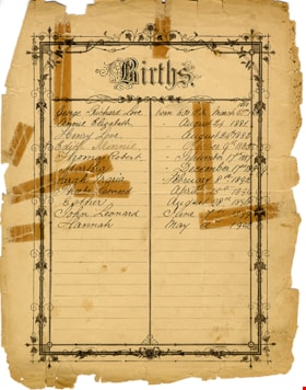
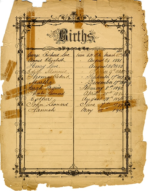
Births of Jesse and Martha Love
https://search.heritageburnaby.ca/link/museumdescription16926
- Repository
- Burnaby Village Museum
- Date
- 1879-1902
- Collection/Fonds
- Love family fonds
- Description Level
- Item
- Physical Description
- 1 p. : 24 x 30 cm
- Scope and Content
- Item consists of a births record page listing the children of Jesse and Martha Love. The page is presumed to be removed from a bible, potentially the Love family bible (BV992.26.1). The information on the obverse reads "Births / George Richard Love born 6:30 P.M March 22nd 1880 / Annie Elizabeth " …
- Repository
- Burnaby Village Museum
- Collection/Fonds
- Love family fonds
- Description Level
- Item
- Physical Description
- 1 p. : 24 x 30 cm
- Scope and Content
- Item consists of a births record page listing the children of Jesse and Martha Love. The page is presumed to be removed from a bible, potentially the Love family bible (BV992.26.1). The information on the obverse reads "Births / George Richard Love born 6:30 P.M March 22nd 1880 / Annie Elizabeth " August 24 1881 / Henry Love " August 24th 1883 / Edith Minnie " October 9th 1885 / Thomas Robert " September 17th 1887 / Martha "December 17th 1889 / Sarah Maria " February 8th 1892 / Phoebe Leonard April 15th 1894 / Esther August 28th 1896 / John Leonard June 7th 1899 / Hannah May 12th 1902". The reverse reads "Deaths" with no further notations.
- Accession Code
- BV992.26.30
- Access Restriction
- No restrictions
- Reproduction Restriction
- No known restrictions
- Date
- 1879-1902
- Media Type
- Textual Record
- Scan Resolution
- 600
- Scan Date
- 2022-06-10
- Notes
- Title based on the content of the page
Images
![Herbert Penrose Vidal, [between 1880 and 1900] thumbnail](/media/hpo/_Data/_Archives_Images/_Unrestricted/550/550-028.jpg?width=280)
Herbert Penrose Vidal
https://search.heritageburnaby.ca/link/archivedescription82383
- Repository
- City of Burnaby Archives
- Date
- [between 1880 and 1900]
- Collection/Fonds
- Hill family and Vidal family fonds
- Description Level
- Item
- Physical Description
- 1 photograph : sepia ; 10 x 6.5 cm
- Scope and Content
- Photograph is a portrait of man identified as Herbert Penrose Vidal.
- Repository
- City of Burnaby Archives
- Date
- [between 1880 and 1900]
- Collection/Fonds
- Hill family and Vidal family fonds
- Physical Description
- 1 photograph : sepia ; 10 x 6.5 cm
- Description Level
- Item
- Record No.
- 550-028
- Access Restriction
- No restrictions
- Reproduction Restriction
- No known restrictions
- Accession Number
- 2013-03
- Scope and Content
- Photograph is a portrait of man identified as Herbert Penrose Vidal.
- Names
- Vidal, Herbert Penrose
- Media Type
- Photograph
- Notes
- Title based on caption accompanying photograph
- Note in pencil on album page reads: "Herbert Penrose Vidal / 1866-1934"
- Note in black pen on verso reads: "H P Vidal"
- Photograph stamp on verso reads: "Barron & Walker / Artists and Photographers / Sarnia / Ont"
Images
![Herbert Penrose Vidal, [between 1880 and 1900] thumbnail](/media/hpo/_Data/_Archives_Images/_Unrestricted/550/550-028.jpg)
![Family album, [between 1880 and 1900] thumbnail](/media/hpo/_Data/_Archives_Images/_Unrestricted/316/335-018-1.jpg?width=280)
Family album
https://search.heritageburnaby.ca/link/archivedescription37214
- Repository
- City of Burnaby Archives
- Date
- [between 1880 and 1900]
- Collection/Fonds
- Burnaby Historical Society fonds
- Description Level
- Item
- Physical Description
- 1 album (43 photographs : b&w ; 17 x 10 cm or smaller) ; 28 x 20 cm
- Scope and Content
- Photograph album consisting of photographs that are likely of members of the Johnson family. Photographs are primarily studio portraits of unidentified individuals, taken in various locations including: Helena, MT; Toronto; Montreal; New Westminster; Fredrikshald, Norway; and Chicago and Roseland, …
- Repository
- City of Burnaby Archives
- Date
- [between 1880 and 1900]
- Collection/Fonds
- Burnaby Historical Society fonds
- Subseries
- Andrew Johnson subseries
- Physical Description
- 1 album (43 photographs : b&w ; 17 x 10 cm or smaller) ; 28 x 20 cm
- Description Level
- Item
- Record No.
- 335-018
- Access Restriction
- No restrictions
- Reproduction Restriction
- No known restrictions
- Accession Number
- BHS1997-16
- Scope and Content
- Photograph album consisting of photographs that are likely of members of the Johnson family. Photographs are primarily studio portraits of unidentified individuals, taken in various locations including: Helena, MT; Toronto; Montreal; New Westminster; Fredrikshald, Norway; and Chicago and Roseland, IL. Photographs depict a group of maids, individuals, children alone or with their parents, and families.
- Subjects
- Documentary Artifacts - Portraits
- Media Type
- Photograph
- Notes
- Title based on contents of item
- Photographer's stamp on recto of 335-018-2 reads: "Wadds Bros / Vancouver & Nelson B.C."
- Photographer's stamp on verso of 335-018-3 reads: "J.H. Lemaitre & Co."
- Photographer's stamp on recto of 335-018-4 reads: "Gagen & Fraser / Toronto"
- Photographer's stamp on recto of 335-018-5 reads: "Perkins / Toronto"
- Photographer's stamp on recto of 335-018-6 reads: "Ahlborn / Chicago"
- Photographer's stamp on verso of 335-018-7 reads: "From the studio of J. B. Cook / ... Toronto"
- Photographer's stamp on recto of 335-018-8 reads: "Wadds Bros / Vancouver, B.C."
- Photographer's stamp on verso of 335-018-9 reads: "Eldridge Stanton / ... Toronto"
- Photographer's stamp on recto of 335-018-10 reads: "Dixon / ... Toronto"
- Photographer's stamp on recto of 335-018-11 reads: "Perkins / Toronto"
- Photographer's stamp on recto of 335-018-12 reads: "Wadds Bros / Vancouver, B.C."
- 335-018-12 is mounted on a sheet of cardboard
- Photographer's stamp on recto of 335-018-14 reads: "Perkins / Toronto"
- Photographer's stamp on verso of 335-018-15 reads: "Eldridge Stanton / ... Toronto"
- Photographer's stamp on recto of 335-018-16 reads: "J.T. Lambly, / ... Montreal"
- Photographer's stamp on recto of 335-018-17 reads: "Buchanan"
- Photographer's stamp on verso of 335-018-18 reads: "Topley" and features an elaborate design
- Photographer's stamp on verso of 335-018-19 reads: "Notman & Fraser" and "Toronto" and features an elaborate design
- Photographer's stamp on recto of 335-018-20 reads: "Farmer Brothers Photographers / Hamilton, Ont"
- Handwritten note on verso of 335-018-20 reads: "I wish you a Merry Christmas"
- Photographer's stamp on recto of 335-018-21 reads: "Perkins / Toronto"
- Photographer's stamp on recto of 335-018-22 reads: "Perkins / Toronto"
- Photographer's stamp on recto of 335-018-23 reads: "Dixon / ... Toronto"
- Photographer's stamp on recto of 335-018-24 reads: "Simpson Bros / ... Toronto"
- Caption on recto of 335-018-25 reads: "Toronto Photo Gallery"
- Photographer's stamp on recto of 335-018-26 reads: "Simpson Bros / ... Toronto"
- Photographer's stamp on recto of 335-018-28 reads: "H.R. Kiopman / Roseland, Ills."
- Photographer's stamp on recto of 335-018-29 reads: "J.G. Parks, Photo. Montreal"
- Photographer's stamp on verso of 335-018-30 reads: "J.G. Parks / ... Montreal"
- Photographer's stamp on recto of 335-018-32 reads: "S. J. Thompson, New Westminster B.C."
- Handwritten note onv erso of 335-018-32 reads: "Yours truly - J. M. McLeod" and "1/18/96"
- Photographer's stamp on verso of 335-018-33 reads: "From Burman's Photographic Rooms / ... Melbourne"
- Caption on recto of 335-018-35 reads: "Sunbeam"
- Photographer's stamp on recto of 335-018-36 reads: "Lemaitre ... Toronto"
- Photographer's stamp on verso of 335-018-37 reads: "Olaf M. Madsen / ... Fredrikshald"
- Date stamp on verso of 335-018-38 reads: "1883/4"
- Photographer's stamp on verso of 335-018-38 reads: "Spencer & Hastings / ... Victoria, B.C"
- Photographer's stamp on recto of 335-018-49 reads: "Olaf M. Madsen / Fredrikshald"
- Photographer's stamp on recto of 335-018-40 reads: "Olaf M. Madsen / Fredrikshald"
- Caption on recto of 335-018-41 reads: "Sunbeam"
- Photographer's stamp on verso of 335-018-42 reads: "Mrs. R. Maynard, / ... Victoria, B.C."
- Photographer's stamp on recto of 335-018-43 reads: "Sunbeam, Galen Block, Helena, M.T."
Images
![Family album, [between 1880 and 1900] thumbnail](/media/hpo/_Data/_Archives_Images/_Unrestricted/316/335-018-1.jpg)

Interview with Marianne May Bateman February 22, 1978 - Track 3
https://search.heritageburnaby.ca/link/oralhistory190
- Repository
- City of Burnaby Archives
- Date Range
- 1880-1920
- Length
- 0:08:39
- Summary
- This portion of the interview pertains to Marianne May Bateman's father Edwin Bateman's history of first coming to Canada.
- Repository
- City of Burnaby Archives
- Summary
- This portion of the interview pertains to Marianne May Bateman's father Edwin Bateman's history of first coming to Canada.
- Date Range
- 1880-1920
- Photo Info
- Photograph of Edwin Wettenhall Bateman with his four daughters; Marianne May is sitting on a chair beside her father, [1903}. Item no. BV992.29.1
- Length
- 0:08:39
- Names
- Bateman, Edwin W.
- Interviewer
- Stevens, Colin
- Interview Date
- February 22, 1978
- Scope and Content
- Recording is of an interview with Marianne May "May" Bateman conducted by Colin Stevens, February 22, 1978. Major themes discussed are: Elworth.
- Biographical Notes
- May Bateman was born in 1894 in Portage LaPrairie, Manitoba to Edwin Wettenhall Bateman and Cassie (Dale) Bateman. May's father, Edwin Bateman was born in 1859 in Sandbach, Cheshire, to James and Caroline Mary Wettenhall Bateman (their home in Sandbach was called Elworth Cottage). When he was twenty-one, E.W. Bateman immigrated to Manitoba, Canada where he met Catherine “Cassie” Dale, daughter of George and Sarah Gillon Dale. They were married in Portage La Prairie, Manitoba on November 9, 1886. Edwin and Cassie had seven children, the eldest Edna Caroline Annie (Corner) born in 1889, George, Mamie (McWilliams) born in 1892, Marianne May “May” Bateman born in 1894, Jessie (Fox Kemp), Carey, and the youngest Warren Stafford born in 1901.Cassie (Dale) Bateman died in Portage La Prairie in 1909. Edwin was transferred to Vancouver by the Canadian Pacific Railway where he married Cassie’s younger sister Mary Dale, born 1865, and moved his six children to Vancouver. The Bateman family first lived at 7th and Balsam in a large new house. It wasn’t until 1920 that they decided to move to the quieter atmosphere of the Burnaby Lake- Deer Lake area. By this time Edwin Wettenhall Bateman was a retired CPR executive. He moved his wife and daughter May to Deer Lake and commissioned 'Elworth' house, designed by English-born and trained architect Enoch Evans. The house was completed by contractor William Dodson in 1922 and located at the site of what would become Burnaby Village Museum, 6501 Deer Lake Avenue. The Batemans lived here for seventeen years before moving back to Vancouver in May of 1935. Mary Bateman died July 5, 1935. Edwin Wettenhall Bateman died on November 25, 1957 at the age of ninety-seven. Marianne May Bateman died in 1990.
- Total Tracks
- 4
- Total Length
- 0:30:44
- Interviewee Name
- Bateman, Marianne May
- Collection/Fonds
- Burnaby Historical Society fonds
- Subseries
- Oral history subseries
- Media Type
- Sound Recording
- Web Notes
- Interview was digitized in 2010 allowing it to be accessible on Heritage Burnaby. The digitization project was initiated by the Community Heritage Commission with support from City of Burnaby Council and the BC History Digitization Program of the Irving K. Barber Learning Centre, University of British Columbia. It was recognized by the Heritage Society of BC with an award in 2012.
Images

Audio Tracks
Track three of interview with May Bateman
Track three of interview with May Bateman
https://search.heritageburnaby.ca/media/hpo/_Data/_Archives_Oral_Histories/_Unrestricted/MSS137-014-1/MSS137-014-1_Track_3.mp3
Interview with Minard Hill February 9, 1978 - Track 3
https://search.heritageburnaby.ca/link/oralhistory196
- Repository
- City of Burnaby Archives
- Date Range
- 1880-1914
- Length
- 0:10:09
- Summary
- This portion of the interview pertains to Minard Gerald "Gerry" Hill's relatives in England, his father's early life as well as life on the strawberry farm in Burnaby.
- Repository
- City of Burnaby Archives
- Summary
- This portion of the interview pertains to Minard Gerald "Gerry" Hill's relatives in England, his father's early life as well as life on the strawberry farm in Burnaby.
- Date Range
- 1880-1914
- Photo Info
- Minard Gerald Hill in uniform, 1914. Item no. 477-926
- Length
- 0:10:09
- Names
- Hill, Bernard R
- Geographic Access
- Douglas Road
- Canada Way
- Historic Neighbourhood
- Burnaby Lake (Historic Neighbourhood)
- Planning Study Area
- Douglas-Gilpin Area
- Interviewer
- Stevens, Colin
- Interview Date
- February 9, 1978
- Scope and Content
- Recording is of an interview with Minard Gerald "Gerry" Hill conducted by Colin Stevens, February 9, 1978. Major themes discussed are: the Burnaby Lake Neighbourhood, Gilley Brothers Logging Company and his father, Bernard Hill.
- Biographical Notes
- Minard Gerald “Gerry” Hill was born in Burnaby on July 31, 1893 to Marian (Berkeley) and Bernard Richard Hill. He was the youngest child in the family with older siblings Frank, Claude and Winnie. Bernard R. Hill was born in Bengal, India while his father worked for the East Indian Railway. He and his older brother Claude became strawberry farmers in Burnaby despite their years of training as engineers. Between them, the Hill brothers owned all the land between Burnaby Lake and Deer Lake where Deer Creek runs, and half way around Deer Lake. Bernard built his family home at Douglas Road near Deer Lake in 1892. After the decline in the strawberry industry, Bernard worked as a surveyor for the municipality. He also served as Burnaby Councillor and School Trustee. Gerry attended Miss Harriet Woodward’s kindergarten class, and went on to Edmonds School with Miss Ellen Lister as his teacher. He later went to Central high school in New Westminster, often on horseback. Gerry served in World War I, signing his recruitment papers November 9, 1914. When he returned home, he worked felling trees, then as an apprentice surveyor and finally as a carpenter. Minard Gerald “Gerry” Hill married Charlotte Elizabeth “Elizabeth” Vidal on September 28, 1920 and single-handedly built a house for him and his wife about a thousand feet from his parents’ home. He also bought property at Yellow Point, Vancouver Island around this time. By the early 1930s Gerry had moved to Yellow Point permanently and begun work building the lodge. Elizabeth and Gerry’s child, Richard Grant McEwan Hill was born at Ladysmith hospital. Charlotte Elizabeth “Elizabeth” (Vidal) Hill died February 11, 1984 at the age of eighty-seven. Minard Gerald “Gerry” Hill died January 30, 1988 at the age of ninety-three.
- Total Tracks
- 8
- Total Length
- 1:13:56
- Interviewee Name
- Hill, Minard Gerald "Gerry"
- Interview Location
- Yellow Point, Vancouver Island
- Collection/Fonds
- Burnaby Historical Society fonds
- Subseries
- Oral history subseries
- Media Type
- Sound Recording
- Web Notes
- Interview was digitized in 2010 allowing it to be accessible on Heritage Burnaby. The digitization project was initiated by the Community Heritage Commission with support from City of Burnaby Council and the BC History Digitization Program of the Irving K. Barber Learning Centre, University of British Columbia. It was recognized by the Heritage Society of BC with an award in 2012.
Images

Audio Tracks
Track three of interview with Minard Hill
Track three of interview with Minard Hill
https://search.heritageburnaby.ca/media/hpo/_Data/_Archives_Oral_Histories/_Unrestricted/MSS137-018-1/MSS137-018-1_Track_3.mp3