Narrow Results By
Format
- Architectural Drawing 239
- Book 792
- Bylaws - Adopted 1652
- Bylaws - Other 20
- Bylaws - Repealed 132
- Cartographic Material 163
- Catalogue 1
- Council - Committee Report 3271
- Council - Manager's Report 6114
- Council - Mayor/Councillor/Staff Report 2444
- Council - Public Hearing Minutes 123
- Council - Regular Council Minutes 852
Decade
- 2020s 2390
- 2010s 6268
- 2000s 9728
- 1990s 13495
- 1980s
- 1970s 18312
- 1960s 12800
- 1950s 11063
- 1940s 7194
- 1930s 7911
- 1920s 12034
- 1910s
- 1900s 4204
- 1890s 1860
- 1880s 298
- 1870s 125
- 1860s 176
- 1850s 45
- 1840s 24
- 1830s 14
- 1820s 11
- 1810s 8
- 1800s 11
- 1790s 6
- 1780s 5
- 1770s 5
- 1760s 5
- 1750s 5
- 1740s 5
- 1730s 5
- 1720s 5
- 1710s
- 1700s 6
- 1690s 5
- 1680s 6
- 1670s 4
- 1660s 4
- 1650s 4
- 1640s 4
- 1630s 4
- 1620s 4
- 1610s 4
- 1600s 4
- 1590s 1
- 1580s 1
- 1570s 1
- 1560s 1
- 1550s 1
- 1540s 1
- 1530s 1
- 1520s 2
- 1510s 1
- 1500s 1
- 1490s 1
- 1480s 1
Subject
- Accidents 2
- Accidents - Train Accidents 1
- Advertising Medium 2
- Advertising Medium - Signs and Signboards 14
- Aerial Photographs 1
- Agricultural Tools and Equipment 1
- Agricultural Tools and Equipment - Gardening Equipment 4
- Agricultural Tools and Equipment - Plows 3
- Agriculture 10
- Agriculture - Crops 6
- Agriculture - Dairy 1
- Agriculture - Farms 28
Creator
- A. A. Marks (firm) 1
- Abbott, George Knapp, 1880-1959 1
- Ackerknecht, Erwin H. (Erwin Heinz), 1906-1988 1
- Adams, Peter 1
- Addingley, Amy 1
- Addington, H.E. 1
- Adee, J. N. 1
- Alberta. Alberta Culture 1
- Alberta Photo Company 1
- Albert F. Arnold 1
- Alcott, Louisa May, 1832-1888 2
- Alexander, Charles M. (Charles McCallon), 1867-1920 1
![CP 6151 at Victoria, [after 1906] thumbnail](/media/hpo/_Data/_BVM_Images/1985/1985_6114_0050_001.jpg?width=280)
CP 6151 at Victoria
https://search.heritageburnaby.ca/link/museumdescription3278
- Repository
- Burnaby Village Museum
- Date
- [after 1906]
- Collection/Fonds
- Burnaby Village Museum Photograph collection
- Description Level
- Item
- Physical Description
- 1 photograph : b&w ; 5.5 x 8 cm
- Scope and Content
- Photograph of Canadian Pacific Railway steam locomotive no. 6151, a 0-6-0 Switcher (built in 1905 and 1906) at Victoria, British Columbia. A railway labourer looks to be cleaning or painting the side of the locomotive.
- Repository
- Burnaby Village Museum
- Collection/Fonds
- Burnaby Village Museum Photograph collection
- Description Level
- Item
- Physical Description
- 1 photograph : b&w ; 5.5 x 8 cm
- Scope and Content
- Photograph of Canadian Pacific Railway steam locomotive no. 6151, a 0-6-0 Switcher (built in 1905 and 1906) at Victoria, British Columbia. A railway labourer looks to be cleaning or painting the side of the locomotive.
- Geographic Access
- Victoria
- Accession Code
- BV985.6114.50
- Access Restriction
- No restrictions
- Reproduction Restriction
- No known restrictions
- Date
- [after 1906]
- Media Type
- Photograph
- Scan Resolution
- 600
- Scan Date
- 2024-03-19
- Notes
- Title based on note written on verso of photograph
- Handwritten note in black ball-point pen on verso of photograph reads: "CP 6151 at/ Victoria"
- Stamp on verso of photograph reads: "840"
Images
![CP 6151 at Victoria, [after 1906] thumbnail](/media/hpo/_Data/_BVM_Images/1985/1985_6114_0050_001.jpg)
![CP 3456 at Drake Street Yard, [after 1906] thumbnail](/media/hpo/_Data/_BVM_Images/1985/1985_6114_0065_001.jpg?width=280)
CP 3456 at Drake Street Yard
https://search.heritageburnaby.ca/link/museumdescription3293
- Repository
- Burnaby Village Museum
- Date
- [after 1906]
- Collection/Fonds
- Burnaby Village Museum Photograph collection
- Description Level
- Item
- Physical Description
- 1 photograph : b&w ; 5.5 x 8 cm
- Scope and Content
- Photograph of Canadian Pacific Railway steam locomotive no. 3456 (built in 1906) at Drake Street Yard in Vancouver.
- Repository
- Burnaby Village Museum
- Collection/Fonds
- Burnaby Village Museum Photograph collection
- Description Level
- Item
- Physical Description
- 1 photograph : b&w ; 5.5 x 8 cm
- Scope and Content
- Photograph of Canadian Pacific Railway steam locomotive no. 3456 (built in 1906) at Drake Street Yard in Vancouver.
- Geographic Access
- Vancouver
- Accession Code
- BV985.6114.65
- Access Restriction
- No restrictions
- Reproduction Restriction
- No known restrictions
- Date
- [after 1906]
- Media Type
- Photograph
- Scan Resolution
- 600
- Scan Date
- 2024-03-19
- Notes
- Title based on note written on verso of photograph
- Handwritten note in black ball-point pen on verso of photograph reads: "CP 3456/ Drake St Yard"
- Stamp on verso of photograph reads: "068"
Images
![CP 3456 at Drake Street Yard, [after 1906] thumbnail](/media/hpo/_Data/_BVM_Images/1985/1985_6114_0065_001.jpg)
![Survey and Subdivision plans in New Westminster District Group 1 - Burnaby
, [1906-1910] thumbnail](/media/hpo/_Data/_BVM_Cartographic_Material/1977/1977_0093_0001a_001.jpg?width=280)
Survey and Subdivision plans in New Westminster District Group 1 - Burnaby
https://search.heritageburnaby.ca/link/museumdescription6970
- Repository
- Burnaby Village Museum
- Date
- [1906-1910]
- Collection/Fonds
- Burnaby Village Museum Map collection
- Description Level
- File
- Physical Description
- 7 plans : blueprint ink on paper + 2 plans : black ink on paper mounted on 2 sides of cardboard 76 cm x 102 cm
- Scope and Content
- Item consists of a large board of six New Westminster District Gp 1 subdivision plans mounted on one side and three New Westminster District Gp 1 subdivision plans mounted on the other side with scales ranging from one chain equals one inch to four chains equals one inch. Side A: 1. Blueprint "Pl…
- Repository
- Burnaby Village Museum
- Collection/Fonds
- Burnaby Village Museum Map collection
- Description Level
- File
- Physical Description
- 7 plans : blueprint ink on paper + 2 plans : black ink on paper mounted on 2 sides of cardboard 76 cm x 102 cm
- Material Details
- Scales [1:792] and [1:3168]
- Index number on edge of board reads: "1"
- Scope and Content
- Item consists of a large board of six New Westminster District Gp 1 subdivision plans mounted on one side and three New Westminster District Gp 1 subdivision plans mounted on the other side with scales ranging from one chain equals one inch to four chains equals one inch. Side A: 1. Blueprint "Plan / of Subdivision / of a portion / of / Lot 13, GR.1 / New Westminster District". Plan is bordered by Cumberland Street, Tenth Ave., Cariboo Street, Armstrong Street, "See Bd.145", Map No891 (Geographic location: Burnaby) 2."Plan / of Subdivision / of a portion / of / Lot 13, GR.1 / New Westminster District". Plan is bordered by Cumberland Street, Tenth Ave., Cariboo St. and Armstrong St. Pencilled annotations on plan read: "for Subdivisions see Board 145"; "Subdivided by H. Neville Smith". (Geographic location: Burnaby) 3. Blueprint "Plan / of Subdivision / of a part / of / Lot 155 / Group 1 / New Westminster District". Plan is bordered by North Arm of Fraser, Wiggins Rd. and Lot 173. Plan created by "NB Gauvreau" (Geographic location: Burnaby) Side B: 1. Blueprint plan which reads: "Albert J. Hill / P.L.S." at top with handwritten annotation: "Lot 85". The plan is bordered by Hastings Rd. and Burnaby Lake with names on lots identified as:"Laura Troop; Jas. Anderson and A. de W. Haszard". (Geographic location: Burnaby) 2. Blueprint plan which reads: "Albert J. Hill / P.L.S" at top with handwritten annotation: "Lot 85". The plan is bordered by Hastings Rd. and Burnaby Lake with names on lots identified as:"Laura Troop; A. de W. Haszard". (Geographic location: Burnaby) 3.Plan of "Survey of Road / for / Burnaby Council". "Albert J. Hill, M.A. Civil Engineer". Plan identifies "Centre Line Lot 10 / Present Road" at the centre and is bordered by Gunn Rd. at the top and Brunette River at the bottom. (Geographic location: Burnaby) 4.Blueprint "Plan / of Subdivision / Lot 97 Group 1/ N.W.D." Plan is bordered by Lots 93, 94 and 96 and Webster Road. Vancouver and New Westminster Road crosses the upper right corner of the plan and the New Westminster Vancouver Tramway runs through from Power House Rd. to Webster Road. Lower right corner identifies "W.N. Draper, P.LotS." (Geographic location: Burnaby) 5. Blueprint "Plan / of / The Subdivision of / Portion of / Lot 85, GP.1 / New Westminster District" Plan is bordered by Lots 79 / Byrne Drive; Burnaby Lake/ Esplanade and Lot 87. Plan is identified with "Albert J. Hill / B.C.LotS. / 19/6/09" (Geographic location: Burnaby) 6. Blueprint "Plan / of Subdivision/ of / Lot 155B, Group One / New Westminster District". Plan is bordered by Lots 155A, 155C, 162 / Byrne Road, 166A / Wiggins Road with Spruce Street running through the middle and Westminster- Eburne Ry. Right of Way running diagonally. Plan is identified with "Albert J. Hill (Geographic location: Burnaby)
- Accession Code
- HV977.93.1
- Access Restriction
- No restrictions
- Reproduction Restriction
- No known restrictions
- Date
- [1906-1910]
- Media Type
- Cartographic Material
- Scan Resolution
- 300
- Scan Date
- 2019-07-16
- Scale
- 72
- Notes
- Title based on contents of file
- Stamp on plans reads: "ALBERT J. HILL M.A. / CIVIL ENGINEER / and / PROVINCIAL LAND SURVEYOR / NEW WESTMINSTER / BC"
- Scale is measured in chains. (One chain equals 792 inches)
Images
![Survey and Subdivision plans in New Westminster District Group 1 - Burnaby
, [1906-1910] thumbnail](/media/hpo/_Data/_BVM_Cartographic_Material/1977/1977_0093_0001a_001.jpg)

Nichols Chemical Company fonds
https://search.heritageburnaby.ca/link/museumdescription18755
- Repository
- Burnaby Village Museum
- Date
- 1906-1962
- Collection/Fonds
- Nichols Chemical Company fonds
- Description Level
- Fonds
- Physical Description
- 9 technical drawings
- Scope and Content
- Fonds consists of technical drawings of the Nichols Chemcial Company plant and machinery.
- Repository
- Burnaby Village Museum
- Collection/Fonds
- Nichols Chemical Company fonds
- Description Level
- Fonds
- Physical Description
- 9 technical drawings
- Scope and Content
- Fonds consists of technical drawings of the Nichols Chemcial Company plant and machinery.
- History
- In 1905 the Nichols Chemical Company, acid manufacturers based in Montreal, established their chemical plant on on a tract of land along Burrard Inlet, just east of the North Pacific Lumber Company. This company was later amalgamated and acquired by General Chemical and remains in operation on the original waterfront site. Many of workers at the Nichols Chemical Plant lived in bunkhouses in the community of Barnet including Japanese Canadian families who were employed there. Many of these families were laid off and forcibily removed during the internment of the Japanese in British Columbia during World War II.
- Creator
- Nichols Chemical Company Limited
- Accession Code
- BV998.23
- Date
- 1906-1962
- Media Type
- Technical Drawing
- Notes
- Title based on contents of fonds
Anne Macey subseries
https://search.heritageburnaby.ca/link/archivedescription97456
- Repository
- City of Burnaby Archives
- Date
- [1905] (date of original)-[between 1940-1959]
- Collection/Fonds
- Burnaby Historical Society fonds
- Description Level
- Subseries
- Physical Description
- Photographs
- Scope and Content
- Subseries consists of photographs compiled by Anne Macey depicting Hart House (also known as "Avalon"), designed by architect Frank W. Macey, and one portrait of Frake W. Macey
- Repository
- City of Burnaby Archives
- Date
- [1905] (date of original)-[between 1940-1959]
- Collection/Fonds
- Burnaby Historical Society fonds
- Subseries
- Anne Macey subseries
- Physical Description
- Photographs
- Description Level
- Subseries
- Accession Number
- BHS1994-01
- BHS2001-03
- Scope and Content
- Subseries consists of photographs compiled by Anne Macey depicting Hart House (also known as "Avalon"), designed by architect Frank W. Macey, and one portrait of Frake W. Macey
- History
- Anne Elizabeth Stokes was born in Misson, BC and raised in Surrey, BC. She married Vancouver Police Department Constable Charles Boyes in 1947, and Major Rolf F. Macey in 1965. Anne and Rolf had two children: son Lane Macey and daughter Naomi Macey. Anne worked as a psychiatric nurse at Essondale Hospital and Director of Volunteer Services at Burnaby General Hospital. She volunteered her time for various clubs, including Save the Children and Dixon House. Anne passed away at Eagle Ridge Manor in Port Moody, BC in 2007.
- Media Type
- Photograph
- Notes
- Title based on creator of subseries
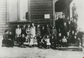
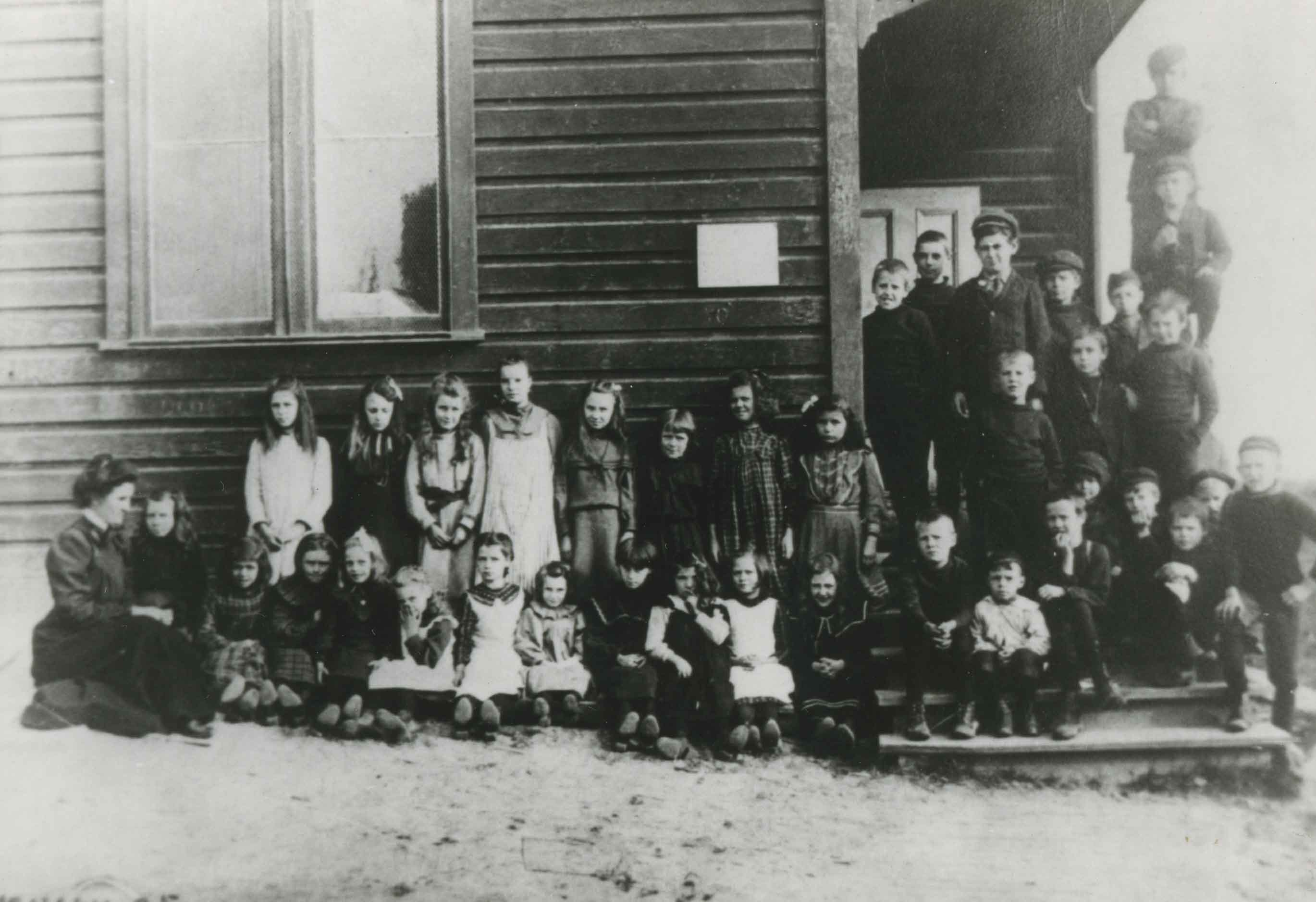
East Burnaby School Class
https://search.heritageburnaby.ca/link/archivedescription34837
- Repository
- City of Burnaby Archives
- Date
- 1905 (date of original), copied 1985
- Collection/Fonds
- Burnaby Historical Society fonds
- Description Level
- Item
- Physical Description
- 1 photograph : b&w ; 8.8 x 12.5 cm print
- Scope and Content
- Photograph of an East Burnaby School (later renamed Edmonds Street School) class. Front row, left to right: Miss Draper, Esther Passmore, Esther Love, Jane Allen, Mary Salt, Fred Madill, Maud Mervin, Ada Lewis, Lillie Lewis, Rose Passmore, [first name unknown] Mervin, Edith Davis (who became Mrs. F…
- Repository
- City of Burnaby Archives
- Date
- 1905 (date of original), copied 1985
- Collection/Fonds
- Burnaby Historical Society fonds
- Subseries
- Every-Clayton family subseries
- Physical Description
- 1 photograph : b&w ; 8.8 x 12.5 cm print
- Description Level
- Item
- Record No.
- 141-007
- Access Restriction
- No restrictions
- Reproduction Restriction
- No known restrictions
- Accession Number
- BHS1985-11
- Scope and Content
- Photograph of an East Burnaby School (later renamed Edmonds Street School) class. Front row, left to right: Miss Draper, Esther Passmore, Esther Love, Jane Allen, Mary Salt, Fred Madill, Maud Mervin, Ada Lewis, Lillie Lewis, Rose Passmore, [first name unknown] Mervin, Edith Davis (who became Mrs. Frank Summers), Ernie Clayton (killed in the first world war), Dick Hall, Stanley Ferguson, Leonard Love, Tom Scott, George Powys, Norman Allen, and Harry Dowling (standing, end of row). Second row, left to right: [first name unknown] Mervin, Winnie Hill, May Wilson, Lizie Hall, Margret McDermit, Francis Clark, Phoebe Love, Manota Vernon, Jack Clayton, Bill Bently, and Edmond Powys. Third row, left to right: Minard Hill, Morris Troup, Bill Davis, Byron Vernon, John Hall, Cicil Ledger, and Edward Clayton (standing on rail).
- Subjects
- Occupations - Teachers
- Names
- Allen, Jane
- Allen Norman
- Bently, Bill
- Edmonds Community School
- Clark, Francis
- Clayton, Edward
- Every-Clayton, Ernest "Ernie"
- Clayton, Jack
- Davis, Bill
- Dowling, Harry
- Ferguson, Stanley
- Hall, Dick
- Hall, John
- Hall, Lizie
- Rowe, Winnie Hill
- Ledger, Cicil
- Lewis, Ada
- Love, Leonard
- Feedham, Phoebe Leonard Love
- Madill, Fred
- McDermit, Margret
- Mervin, Maud
- Hill, Minard Gerald "Gerry"
- Passmore, Esther
- Passmore, Rose
- Porter, Lillie Lewis
- Powys, George
- Powys, Edmond
- Salt, Mary
- Scott, Tom
- Stanley, Esther Love
- Summers, Edith Davis
- Troup, Morris
- Vernon, Byron
- Vernon, Manota
- Wilson, May
- Media Type
- Photograph
- Notes
- Title based on contents of photograph
- Historic Neighbourhood
- Edmonds (Historic Neighbourhood)
Images
![Douglas Road, Burnaby, [1908] thumbnail](/media/hpo/_Data/_Archives_Images/_Unrestricted/371/449-009.jpg?width=280)
Douglas Road, Burnaby
https://search.heritageburnaby.ca/link/archivedescription38514
- Repository
- City of Burnaby Archives
- Date
- [1908]
- Collection/Fonds
- Burnaby Historical Society fonds
- Description Level
- Item
- Physical Description
- 1 photograph : sepia postcard ; 8.8 x 14 cm
- Scope and Content
- Photographic postcard taken looking northwest along Douglas Road (now Canada Way) near Stanley Street. Two unidentified people are standing next to a wooden fence running alongside the road (above Lubbock's Creek) and a number of houses (including the Sprott house) are visible in the background. To…
- Repository
- City of Burnaby Archives
- Date
- [1908]
- Collection/Fonds
- Burnaby Historical Society fonds
- Subseries
- Photographs subseries
- Physical Description
- 1 photograph : sepia postcard ; 8.8 x 14 cm
- Description Level
- Item
- Record No.
- 449-009
- Access Restriction
- No restrictions
- Reproduction Restriction
- No known restrictions
- Accession Number
- BHS2007-04
- Scope and Content
- Photographic postcard taken looking northwest along Douglas Road (now Canada Way) near Stanley Street. Two unidentified people are standing next to a wooden fence running alongside the road (above Lubbock's Creek) and a number of houses (including the Sprott house) are visible in the background. To the right is Burnaby Lake. Stamped at the top of the postcard is "Douglas Road, Burnaby / New Westminster BC."
- Subjects
- Geographic Features - Lakes and Ponds
- Documentary Artifacts - Postcards
- Geographic Features - Roads
- Media Type
- Photograph
- Geographic Access
- Douglas Road
- Stanley Street
- Canada Way
- Deer Lake
- Historic Neighbourhood
- Burnaby Lake (Historic Neighbourhood)
- Planning Study Area
- Lakeview-Mayfield Area
Images
![Douglas Road, Burnaby, [1908] thumbnail](/media/hpo/_Data/_Archives_Images/_Unrestricted/371/449-009.jpg)
![Herbert, Charlotte, Dorothy, and Alexander Vidal, [between 1905 and 1910] thumbnail](/media/hpo/_Data/_Archives_Images/_Unrestricted/550/550-035.jpg?width=280)
Herbert, Charlotte, Dorothy, and Alexander Vidal
https://search.heritageburnaby.ca/link/archivedescription82406
- Repository
- City of Burnaby Archives
- Date
- [between 1905 and 1910]
- Collection/Fonds
- Hill family and Vidal family fonds
- Description Level
- Item
- Physical Description
- 1 photograph : b&w ; 8 x 11 cm
- Scope and Content
- Photograph shows a man, two girls, and a boy identified as Herbert Penrose Vidal, Charlotte Elizabeth Vidal Hill, Dorothy Kate Vidal Loomis, and Alexander E. E. "Bill" Vidal. The children are in the stream and the man is sitting beside a campfire.
- Repository
- City of Burnaby Archives
- Date
- [between 1905 and 1910]
- Collection/Fonds
- Hill family and Vidal family fonds
- Physical Description
- 1 photograph : b&w ; 8 x 11 cm
- Description Level
- Item
- Record No.
- 550-035
- Access Restriction
- No restrictions
- Reproduction Restriction
- No known restrictions
- Accession Number
- 2013-03
- Scope and Content
- Photograph shows a man, two girls, and a boy identified as Herbert Penrose Vidal, Charlotte Elizabeth Vidal Hill, Dorothy Kate Vidal Loomis, and Alexander E. E. "Bill" Vidal. The children are in the stream and the man is sitting beside a campfire.
- Subjects
- Recreational Activities - Camping
- Names
- Hill, Charlotte Elizabeth Vidal
- Loomis, Dorothy Kate Vidal
- Vidal, Alexander E. E. "Bill"
- Vidal, Herbert Penrose
- Media Type
- Photograph
- Notes
- Title based on caption accompanying photograph and contents of photograph
- Note in pencil on album page reads: "Herbert Vidal / Charlotte / Dorothy / Alex / Near Philadelphia"
- Note in blue pen on verso reads: "near Philadelphia / Grandad / Mom / Aunt Dor / Uncle Bill"
Images
![Herbert, Charlotte, Dorothy, and Alexander Vidal, [between 1905 and 1910] thumbnail](/media/hpo/_Data/_Archives_Images/_Unrestricted/550/550-035.jpg)
![Charlotte and Dorothy Vidal holding puppies, [between 1905 and 1910] thumbnail](/media/hpo/_Data/_Archives_Images/_Unrestricted/550/550-046.jpg?width=280)
Charlotte and Dorothy Vidal holding puppies
https://search.heritageburnaby.ca/link/archivedescription82426
- Repository
- City of Burnaby Archives
- Date
- [between 1905 and 1910]
- Collection/Fonds
- Hill family and Vidal family fonds
- Description Level
- Item
- Physical Description
- 1 photograph : b&w ; 9 x 9.5 cm
- Scope and Content
- Photograph shows a portrait of two girls each holding a puppy and flanking an unidentified boy. The girls identified from left to right are Dorothy Vidal and Charlotte Vidal.
- Repository
- City of Burnaby Archives
- Date
- [between 1905 and 1910]
- Collection/Fonds
- Hill family and Vidal family fonds
- Physical Description
- 1 photograph : b&w ; 9 x 9.5 cm
- Description Level
- Item
- Record No.
- 550-046
- Access Restriction
- No restrictions
- Reproduction Restriction
- No known restrictions
- Accession Number
- 2013-03
- Scope and Content
- Photograph shows a portrait of two girls each holding a puppy and flanking an unidentified boy. The girls identified from left to right are Dorothy Vidal and Charlotte Vidal.
- Subjects
- Animals - Dogs
- Media Type
- Photograph
- Notes
- Title based on note accompanying photograph and contents of photograph
- Note at bottom of album page in pencil reads: "Charlotte & Dorothy / Ioco, BC"
- Note in blue pen on verso reads: "Mom & Aunt Dor / Ioco"
Images
![Charlotte and Dorothy Vidal holding puppies, [between 1905 and 1910] thumbnail](/media/hpo/_Data/_Archives_Images/_Unrestricted/550/550-046.jpg)
Mortgage (Booth, Frank)
https://search.heritageburnaby.ca/link/archivedescription217
- Repository
- City of Burnaby Archives
- Date
- 1905-1912
- Collection/Fonds
- City Council and Office of the City Clerk fonds
- Description Level
- File
- Physical Description
- Textual record
- Repository
- City of Burnaby Archives
- Date
- 1905-1912
- Collection/Fonds
- City Council and Office of the City Clerk fonds
- Physical Description
- Textual record
- Description Level
- File
- Record No.
- 1903
- Accession Number
- 2001-02
- Media Type
- Textual Record
Gunn Road diversion (Banfield, J.J.)
https://search.heritageburnaby.ca/link/archivedescription319
- Repository
- City of Burnaby Archives
- Date
- 1905-1911
- Collection/Fonds
- City Council and Office of the City Clerk fonds
- Description Level
- File
- Physical Description
- Textual record and cartographic material
- Scope and Content
- File contains records, including blueprint, related to the proposed diversion of Gunn Road.
- Repository
- City of Burnaby Archives
- Date
- 1905-1911
- Collection/Fonds
- City Council and Office of the City Clerk fonds
- Physical Description
- Textual record and cartographic material
- Description Level
- File
- Record No.
- 2010
- Accession Number
- 2001-02
- Scope and Content
- File contains records, including blueprint, related to the proposed diversion of Gunn Road.
- Media Type
- Textual Record
- Cartographic Material
- Notes
- White linen plan : Diversion of Gunn Road Lots 10 and 4 Group One" : M9-A-3-17.
John Green/Hunter T. Brown mortgage
https://search.heritageburnaby.ca/link/archivedescription429
- Repository
- City of Burnaby Archives
- Date
- 1905-1917
- Collection/Fonds
- City Council and Office of the City Clerk fonds
- Description Level
- File
- Physical Description
- Textual record
- Scope and Content
- File contains agreements, insurance policies and other records related to the mortgage held by Hunter T. Brown on property Block 46, DL 152 and 153. File also includes John Green Mortgage, Block 46, DL 152 and 153 (1905 and 1906) and Brown Fire Insurance (1911-1917).
- Repository
- City of Burnaby Archives
- Date
- 1905-1917
- Collection/Fonds
- City Council and Office of the City Clerk fonds
- Physical Description
- Textual record
- Description Level
- File
- Record No.
- 2130
- Accession Number
- 2001-02
- Scope and Content
- File contains agreements, insurance policies and other records related to the mortgage held by Hunter T. Brown on property Block 46, DL 152 and 153. File also includes John Green Mortgage, Block 46, DL 152 and 153 (1905 and 1906) and Brown Fire Insurance (1911-1917).
- Media Type
- Textual Record
Buxton family fonds
https://search.heritageburnaby.ca/link/archivedescription64596
- Repository
- City of Burnaby Archives
- Date
- [1905-1915]
- Collection/Fonds
- Buxton Family fonds
- Description Level
- Fonds
- Physical Description
- 16 photographs (jpeg) : b&w and sepia
- Scope and Content
- Fonds consists of photographs of George Buxton and the construction of the Buxton family home in Burnaby, as well as photographs of Leopold Buxton and other members of the Buxton family.
- Repository
- City of Burnaby Archives
- Date
- [1905-1915]
- Collection/Fonds
- Buxton Family fonds
- Physical Description
- 16 photographs (jpeg) : b&w and sepia
- Description Level
- Fonds
- Record No.
- 41960
- Access Restriction
- No restrictions
- Reproduction Restriction
- May be restricted by third-party rights
- Accession Number
- 2010-05
- Scope and Content
- Fonds consists of photographs of George Buxton and the construction of the Buxton family home in Burnaby, as well as photographs of Leopold Buxton and other members of the Buxton family.
- History
- George Searby Buxton (1867-1955) was born in England and was a carpenter by trade. He married Mary Isabel Nattriss (1866-1941), a teacher, and moved to Canada in 1911. In 1912, George built an arts and crafts style home in Burnaby which remains as one of the City's heritage buildings to this day. George and Mary had five children: Clara Violet (1910-1913), Mary (1900-?), Alice Clarissa (Clissie) (1902-?), Bernard (1897-1972) and Leopold (1893-1951).
- Media Type
- Photograph
- Other Title Information
- Title was changed from Buxton family collection to Buxton family fonds to better reflect the nature of the materials.
- Notes
- Photo catalogue 513
![R. D. Peers, [1910] thumbnail](/media/hpo/_Data/_Archives_Images/_Unrestricted/477/477-915.jpg?width=280)
R. D. Peers
https://search.heritageburnaby.ca/link/archivedescription66158
- Repository
- City of Burnaby Archives
- Date
- [1910]
- Collection/Fonds
- Peers Family and Hill Family fonds
- Description Level
- Item
- Physical Description
- 1 photograph : sepai ; 9 x 6 cm
- Scope and Content
- Photograph is a head and shoulders portrait of Dick Peers, the youngest of the four Peers brothers and son of Francis John and Annie Elizabeth Peers.
- Repository
- City of Burnaby Archives
- Date
- [1910]
- Collection/Fonds
- Peers Family and Hill Family fonds
- Physical Description
- 1 photograph : sepai ; 9 x 6 cm
- Description Level
- Item
- Record No.
- 477-915
- Access Restriction
- No restrictions
- Reproduction Restriction
- No known restrictions
- Accession Number
- 2007-12
- Scope and Content
- Photograph is a head and shoulders portrait of Dick Peers, the youngest of the four Peers brothers and son of Francis John and Annie Elizabeth Peers.
- Media Type
- Photograph
- Notes
- Title based on contents of photograph
Images
![R. D. Peers, [1910] thumbnail](/media/hpo/_Data/_Archives_Images/_Unrestricted/477/477-915.jpg)
![Class at West Burnaby School, [between 1905 and 1915] thumbnail](/media/hpo/_Data/_BVM_Images/1990/199900020030.jpg?width=280)
Class at West Burnaby School
https://search.heritageburnaby.ca/link/museumdescription1342
- Repository
- Burnaby Village Museum
- Date
- [between 1905 and 1915]
- Collection/Fonds
- Burnaby Village Museum Photograph collection
- Description Level
- Item
- Physical Description
- 1 photograph : b&w ; 5.5 x 10 cm, mounted on black paper 8.5 x 12 cm
- Scope and Content
- Photograph of children in a classroom at West Burnaby (later renamed Kingsway West) School. Several girls are wearing big bows in their hair and a number of children are in sailor suits.
- Repository
- Burnaby Village Museum
- Collection/Fonds
- Burnaby Village Museum Photograph collection
- Description Level
- Item
- Physical Description
- 1 photograph : b&w ; 5.5 x 10 cm, mounted on black paper 8.5 x 12 cm
- Material Details
- Photograph is mounted on black paper; possibly cut out of a photographic album
- Scope and Content
- Photograph of children in a classroom at West Burnaby (later renamed Kingsway West) School. Several girls are wearing big bows in their hair and a number of children are in sailor suits.
- Names
- Kingsway West School
- Geographic Access
- Kingsway
- Street Address
- 4800 Kingsway
- Accession Code
- BV999.2.30
- Access Restriction
- No restrictions
- Reproduction Restriction
- May be restricted by third party rights
- Date
- [between 1905 and 1915]
- Media Type
- Photograph
- Historic Neighbourhood
- Central Park (Historic Neighbourhood)
- Planning Study Area
- Maywood Area
- Scan Resolution
- 600
- Scan Date
- 08-Jun-09
- Scale
- 100
- Notes
- Title based on contents of photograph
Images
![Class at West Burnaby School, [between 1905 and 1915] thumbnail](/media/hpo/_Data/_BVM_Images/1990/199900020030.jpg)
![Nashwaak cabin, [between 1905 and 1920] thumbnail](/media/hpo/_Data/_BVM_Images/1985/1985_5817_0001_001.jpg?width=280)
Nashwaak cabin
https://search.heritageburnaby.ca/link/museumdescription1442
- Repository
- Burnaby Village Museum
- Date
- [between 1905 and 1920]
- Collection/Fonds
- Burnaby Village Museum Photograph collection
- Description Level
- Item
- Physical Description
- 1 photograph : b&w
- Scope and Content
- Photograph of an unidentified woman and girl standing beside a cabin with a sign "Nashwaak" propped up on a tree stump and leaning against the cabin. There is a washtub to the left side of the photograph. The area appears vacant, and location is not identified.
- Repository
- Burnaby Village Museum
- Collection/Fonds
- Burnaby Village Museum Photograph collection
- Description Level
- Item
- Physical Description
- 1 photograph : b&w
- Scope and Content
- Photograph of an unidentified woman and girl standing beside a cabin with a sign "Nashwaak" propped up on a tree stump and leaning against the cabin. There is a washtub to the left side of the photograph. The area appears vacant, and location is not identified.
- Subjects
- Buildings - Residential - Cabins
- Accession Code
- BV985.5817.1
- Access Restriction
- No restrictions
- Reproduction Restriction
- No known restrictions
- Date
- [between 1905 and 1920]
- Media Type
- Photograph
- Scan Resolution
- 600
- Scan Date
- 2024-02-27
- Notes
- Title based on contents of photograph
Images
![Nashwaak cabin, [between 1905 and 1920] thumbnail](/media/hpo/_Data/_BVM_Images/1985/1985_5817_0001_001.jpg)
![Love family, [between 1905 and 1910] thumbnail](/media/hpo/_Data/_BVM_Images/1985/198800450001.jpg?width=280)
Love family
https://search.heritageburnaby.ca/link/museumdescription2976
- Repository
- Burnaby Village Museum
- Date
- [between 1905 and 1910]
- Collection/Fonds
- Love family fonds
- Description Level
- Item
- Physical Description
- 1 photograph : b&w postcard ; 8 x 13 cm
- Scope and Content
- Photographic postcard of the Love family taken outside on the grass. Their tri-coloured border collie is lying in the front row and a black poodle is standing over him, licking his face. This group is identified as; (back row, l to r) Phoebe Love (later Feedham), unidentified young woman in large h…
- Repository
- Burnaby Village Museum
- Collection/Fonds
- Love family fonds
- Description Level
- Item
- Physical Description
- 1 photograph : b&w postcard ; 8 x 13 cm
- Scope and Content
- Photographic postcard of the Love family taken outside on the grass. Their tri-coloured border collie is lying in the front row and a black poodle is standing over him, licking his face. This group is identified as; (back row, l to r) Phoebe Love (later Feedham), unidentified young woman in large hat, Sarah Love (later Parker), William Michael Parker (later married Sarah Love), Martha (Dot) Love (later Brandrith); (mid row, l to r) Henry Love, George Love, Albert Lewis (neighbor of the Love family); (front row, l to r) Esther Love (later Stanley), Leonard Love, and Hannah (Girlie) Love (later Barnes).
- Subjects
- Animals - Dogs
- Names
- Feedham, Phoebe Leonard Love
- Lewis, Albert
- Love, George Richard
- Barnes, Hannah Victoria "Girlie" Love
- Love, Henry
- Love, John Leonard
- Parker, Sarah Maria Love
- Parker, William Michael
- Stanley, Esther Love
- Brandrith, Martha Dorothy “Dot” Love
- Love Family
- Accession Code
- BV988.45.1
- Access Restriction
- No restrictions
- Date
- [between 1905 and 1910]
- Media Type
- Photograph
- Related Material
- For a copy print of the same image taken from the Bernard Hill family album, see HV977.123.39
- See also BV022.32.222 for similar photo
- Scan Resolution
- 600
- Scan Date
- 01-Jun-09
- Scale
- 100
- Notes
- Title based on contents of photograph
- Note on verso of postcard reads: "LOVE FAMILY"
Images
![Love family, [between 1905 and 1910] thumbnail](/media/hpo/_Data/_BVM_Images/1985/198800450001.jpg)
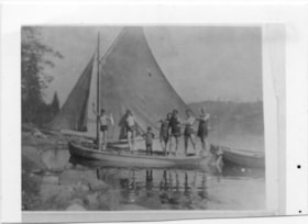
Men and boys standing on schooner
https://search.heritageburnaby.ca/link/museumdescription4783
- Repository
- Burnaby Village Museum
- Date
- 1905-1940
- Collection/Fonds
- Burnaby Village Museum Photograph collection
- Description Level
- Item
- Physical Description
- 1 photograph : b&w ; 6.3 x 8.10 cm ; copy print
- Scope and Content
- Schooner with sails up and tender on calm water close to rocky shore. 7 boys men wearing bathing costumes are standing on deck.
- Repository
- Burnaby Village Museum
- Collection/Fonds
- Burnaby Village Museum Photograph collection
- Description Level
- Item
- Physical Description
- 1 photograph : b&w ; 6.3 x 8.10 cm ; copy print
- Material Details
- "Columbian files 1971" written on verso in black pen.
- Scope and Content
- Schooner with sails up and tender on calm water close to rocky shore. 7 boys men wearing bathing costumes are standing on deck.
- History
- Part of a set of photographs from the Columbian Newspaper, which operated out of New Westminster under this name starting in 1900 until its dissolution in 1988. Photographs found in the collection of the Burnaby Village are dated 1971.
- Other Title Information
- title based on content of photograph
- Accession Code
- BV018.19.9
- Access Restriction
- No restrictions
- Reproduction Restriction
- May be restricted by third party rights
- Date
- 1905-1940
- Media Type
- Photograph
- Scan Resolution
- 600
- Scan Date
- 24-04-2018
Images

![Subdivision plans in New Westminster District Group 1 – Burnaby, [1905-1910] thumbnail](/media/hpo/_Data/_BVM_Cartographic_Material/1977/1977_0093_0011a_001.jpg?width=280)
Subdivision plans in New Westminster District Group 1 – Burnaby
https://search.heritageburnaby.ca/link/museumdescription6980
- Repository
- Burnaby Village Museum
- Date
- [1905-1910]
- Collection/Fonds
- Burnaby Village Museum Map collection
- Description Level
- File
- Physical Description
- 4 plans : blueprint ink on paper mounted on 2 sides of cardboard 76 x 102 cm
- Scope and Content
- Item consists of a large board of two New Westminster District Gp 1 - subdivision plans mounted on one side and two New Westminster District subdivision plans mounted on the other side. Side A: 1.Blueprint "Plan / of Subdivision / of a Portion / of / Lot 90 / Group One / New Westmisnter Distric…
- Repository
- Burnaby Village Museum
- Collection/Fonds
- Burnaby Village Museum Map collection
- Description Level
- File
- Physical Description
- 4 plans : blueprint ink on paper mounted on 2 sides of cardboard 76 x 102 cm
- Material Details
- Scales [between 1:1200 and 1:3960]
- Index number on edge of board reads: "11"
- Scope and Content
- Item consists of a large board of two New Westminster District Gp 1 - subdivision plans mounted on one side and two New Westminster District subdivision plans mounted on the other side. Side A: 1.Blueprint "Plan / of Subdivision / of a Portion / of / Lot 90 / Group One / New Westmisnter District / Scale 200 ft = 1 in. / Map No 642". (Geographic location: Burnaby) 2. Blueprint "Plan / of Subdivision / of / North Portion / of / Lot 28 / Group One / New Westminster District / Scale 100' = 1 in. / Map No 632". Geographic location: Burnaby) Side B: 1. Blueprint "Plan / of Subdivision of Lot 153 / Group 1 / New Westminster Dist. / Scale 5 chs = 1 in. / Map No. 783". Handwritten annotation in red reads: "NOTE. THIS INCLUDEDS PART / OF LOT 151. & 152". Geographic location: Burnaby) 2. Blueprint "Plan / of Subdivision of Lot 82, Group 1 / New Westminster Dist. / Scale 2 chs = 1 in. / Map No 201". Geographic location: Burnaby)
- Accession Code
- HV977.93.11
- Access Restriction
- No restrictions
- Reproduction Restriction
- No known restrictions
- Date
- [1905-1910]
- Media Type
- Cartographic Material
- Scan Resolution
- 300
- Scale
- 72
- Notes
- Title based on contents of file
- Scale is measured in chains and feet. (One chain equals 792 inches)
- The term "Lot" can also refer to a "District Lot”
Images
![Subdivision plans in New Westminster District Group 1 – Burnaby, [1905-1910] thumbnail](/media/hpo/_Data/_BVM_Cartographic_Material/1977/1977_0093_0011a_001.jpg)

![Survey and Subdivision plans in New Westminster District Group 1 – Burnaby
, [1905-1912] thumbnail](/media/hpo/_Data/_BVM_Cartographic_Material/1977/1977_0093_0021a_001.jpg?width=280)
Survey and Subdivision plans in New Westminster District Group 1 – Burnaby
https://search.heritageburnaby.ca/link/museumdescription6990
- Repository
- Burnaby Village Museum
- Date
- [1905-1912]
- Collection/Fonds
- Burnaby Village Museum Map collection
- Description Level
- File
- Physical Description
- 10 plans : 2 blueprint on paper + 7 black ink on paper + 1 graphite on paper mounted on cardboard 76 x 102 cm
- Scope and Content
- Item consists of a large board of five New Westminster District subdivision plans mounted on one side and five New Westminster District subdivision plans mounted on the other side. Side A: 1. "Survey / of / a Portion / of / Lot 95 Gr.1 / Scale : 1 ch = 1 in". Plan shows Lot 9, Lot 10 and Lot 11 o…
- Repository
- Burnaby Village Museum
- Collection/Fonds
- Burnaby Village Museum Map collection
- Description Level
- File
- Physical Description
- 10 plans : 2 blueprint on paper + 7 black ink on paper + 1 graphite on paper mounted on cardboard 76 x 102 cm
- Material Details
- Scales [between 1:792 and 1:3960]
- Index number on edge of board reads: "21"
- Scope and Content
- Item consists of a large board of five New Westminster District subdivision plans mounted on one side and five New Westminster District subdivision plans mounted on the other side. Side A: 1. "Survey / of / a Portion / of / Lot 95 Gr.1 / Scale : 1 ch = 1 in". Plan shows Lot 9, Lot 10 and Lot 11 of District Lot 95, northeast of Vancouver Road and B.C.E. Tramway. Plan is initialed by: "RB" [sic] (in blue pencil crayon) (Geographic location: Burnaby) 2. Plan of "Lot 12, 13, 2, Gr.1" (handwritten in blue crayon) with Note: "Figures shown in / Red are from Reg. / Plan No 898" and "Scale 4 chains to 1 inch" (written in graphite). Plan identifies the Brunette River running through Lot 12, Lot 13 and Lot 1 and is bordered by North Road to the east and Cariboo Road to the south west. Plan is initialed by: "RB" [sic] (in blue pencil crayon) and stamped: "Albert J. Hill, Civil Engineer / and / Provincial Land Surveyor, / New Westminster, / B.C." (Geographic location: Burnaby) 3. Subdivision plan of a "Portion / of / Lot 29 Gr.1" The plan shows Lots two through fourteen North of Vancouver Road. Name on plan reads: "Reichenbach" and "Scale 2 chs = 1 in" . Plan is initialed by: "RB" [sic] (in blue pencil crayon) nd stamped: "Albert J. Hill, Civil Engineer / and / Provincial Land Surveyor, / New Westminster, / B.C." (Geographic location: Burnaby) 4. Plan of "SUBDvn 10, L88 / "Sc. 1 ch = 1 in / Albert J. Hill / P.L.S.". Plan shows Lot 88 and Lot 25 running along a ravine and Cumberland Street and identifies the "Jensen" house as well as a "stable" and "barn". Plan is initialed by: "RB" [sic] (in blue pencil crayon) and stamped: "Albert J. Hill, Civil Engineer / and / Provincial Land Surveyor, / New Westminster, / B.C." Note handwritten in pencil reads: "Cancelled / See other Side". See also plan 3B. (Geographic location: Burnaby) 5. "Survey / of / Roberts Road / and / Power House Road / Scale 200' = 1" ". Survey for roads identifies North Arm Road, Byrne Road, Woollard, Lot 155A, Lot 160, Lot 159, Lot 96 and Lot 97. Plan is initialed by: "RB" [sic] (in blue pencil crayon) and stamped: "Albert J. Hill, Civil Engineer / and / Provincial Land Surveyor, / New Westminster, / B.C." (Geographic location: Burnaby) Side B: 1. Plan of "Lot 29, G. 1" "McDonald's Lot / Vancouver Road". Plan shows the subdivision of District Lot 29 with the name "S McDonald" marked on one lot next to another identified as "Carter Smith". Lots within survey plan are all north of Vancouver Road and west of Wise Road. Plan is initialed by: "RB" [sic] (in blue pencil crayon) (Geographic location: Burnaby) 2. Plan of "Location / for Burnaby Council / of / the West Boundary of Lots 161 & 175 / Group One" Plan is initialed by: "RB" [sic] (in blue pencil crayon) and stamped: "Albert J. Hill, Civil Engineer / and / Provincial Land Surveyor, / New Westminster, / B.C." (Geographic location: Burnaby) 3. Blueprint plan of "SUBDvn 10, L88 / "Sc. 1 ch = 1 in / Albert J. Hill / P.L.S.". Subdivision plan shows Lot 88 and Lot 25 running along a ravine and Cumberland Street and identifies the "Jensen" house as well as a "stable" and "barn". Plan is initialed by: "RB" [sic] with note "Previous map on / other side hereof" (in blue pencil crayon). See also plan 4A. (Geographic location: Burnaby) 4. Plan titled: "Western Addition / Plan of Subdivision / of / Lots 159_160 / and Part of / Lot 158 / Group One / New Westminster District / Scale : 5 chs = 1 in / to The City of / New Westminster." Plan is initialed by: "RB" [sic] (in blue pencil crayon) (Geographic location: Burnaby) 5. Plan "of Resubdivision/ of Lot 11 / in the Subdivision / of Lots D, C, & G / Lot 96 / Group One / New Westminster District / Scale 2 ch = 1 in" Plan is initialed by: "RB" [sic] (in blue pencil crayon) (Geographic location: Burnaby)
- Creator
- Hill, Albert James
- Accession Code
- HV977.93.21
- Access Restriction
- No restrictions
- Reproduction Restriction
- No known restrictions
- Date
- [1905-1912]
- Media Type
- Cartographic Material
- Scan Resolution
- 300
- Scale
- 72
- Notes
- Title based on contents of file
- Scale is measured in chains and feet. (One chain equals 792 inches)
- The term "Lot" can also refer to a "District Lot”
Images
![Survey and Subdivision plans in New Westminster District Group 1 – Burnaby
, [1905-1912] thumbnail](/media/hpo/_Data/_BVM_Cartographic_Material/1977/1977_0093_0021a_001.jpg)
