Narrow Results By
Burnaby's first Public School
https://search.heritageburnaby.ca/link/archivedescription35881
- Repository
- City of Burnaby Archives
- Date
- February 1894 (date of original), copied 1986
- Collection/Fonds
- Burnaby Historical Society fonds
- Description Level
- Item
- Physical Description
- 1 photograph : b&w ; 12.7 x 17.8 cm print
- Scope and Content
- Photograph of school officials standing on the steps of the first public school in Burnaby, Douglas Road and Edmonds Street. Left to right: William McDermott (school trustee), Ethel Lepage (first teacher), Lancelot Grimmer (school trustee), and Bernard Hill (school board chairman and secretary). Th…
- Repository
- City of Burnaby Archives
- Date
- February 1894 (date of original), copied 1986
- Collection/Fonds
- Burnaby Historical Society fonds
- Subseries
- Pioneer Tales subseries
- Physical Description
- 1 photograph : b&w ; 12.7 x 17.8 cm print
- Description Level
- Item
- Record No.
- 204-740
- Access Restriction
- No restrictions
- Reproduction Restriction
- No known restrictions
- Accession Number
- BHS1988-03
- Scope and Content
- Photograph of school officials standing on the steps of the first public school in Burnaby, Douglas Road and Edmonds Street. Left to right: William McDermott (school trustee), Ethel Lepage (first teacher), Lancelot Grimmer (school trustee), and Bernard Hill (school board chairman and secretary). The school was called Burnaby School from 1894 to 1896, and then East Burnaby School from 1896 to 1907. The present day address of the site is 7376 Canada Way.
- Subjects
- Officials
- Occupations - Teachers
- Media Type
- Photograph
- Notes
- Title based on contents of photograph
- Geographic Access
- Canada Way
- Street Address
- 7376 Canada Way
- Historic Neighbourhood
- Edmonds (Historic Neighbourhood)
- Planning Study Area
- Edmonds Area
Images
Canada Way Food Market and Toy residence
https://search.heritageburnaby.ca/link/museumdescription20350
- Repository
- Burnaby Village Museum
- Date
- 13 Jun. 2023
- Collection/Fonds
- Harry Toy fonds
- Description Level
- Item
- Physical Description
- 1 photograph (tiff) : col.
- Scope and Content
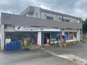
- Photograph of the exterior of Canada Way Food Market building and Toy family residence (above) located at 4694 Canada Way. Blue plastic food crates, store racks and car tires are in the parking area in front of the store. The food market closed in 2010.
- Repository
- Burnaby Village Museum
- Collection/Fonds
- Harry Toy fonds
- Series
- Harry Toy photographs series
- Description Level
- Item
- Physical Description
- 1 photograph (tiff) : col.
- Scope and Content
- Photograph of the exterior of Canada Way Food Market building and Toy family residence (above) located at 4694 Canada Way. Blue plastic food crates, store racks and car tires are in the parking area in front of the store. The food market closed in 2010.
- Subjects
- Buildings - Commercial - Stores
- Names
- Canada Way Food Market
- Geographic Access
- Canada Way
- Street Address
- 4694 Canada Way
- Accession Code
- BV023.25.2
- Access Restriction
- No restrictions
- Reproduction Restriction
- No known restrictions
- Date
- 13 Jun. 2023
- Media Type
- Photograph
- Related Material
- See also BV023.16.19 - Interview with Harry Toy, Beverley Babey and Christina Toy
- For associated artifacts from Canada Way Food Market see Accession BV023.17
- Scan Date
- 2023-06-13
- Photographer
- Petrusa, Kate
- Notes
- Title based on contents of photograph
Images
Cigarette price sign inside of Canada Way Food Market
https://search.heritageburnaby.ca/link/museumdescription20349
- Repository
- Burnaby Village Museum
- Date
- 13 Jun. 2023
- Collection/Fonds
- Harry Toy fonds
- Description Level
- Item
- Physical Description
- 1 photograph (jpg) : col.
- Scope and Content
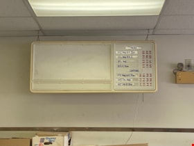
- Photograph of cigarette price display sign hanging from ceiling inside of the Canada Way Food Market located at 4694 Canada Way, Burnaby. Boxes are visible beneath the sign. The food market closed in 2010.
- Repository
- Burnaby Village Museum
- Collection/Fonds
- Harry Toy fonds
- Series
- Harry Toy photographs series
- Description Level
- Item
- Physical Description
- 1 photograph (jpg) : col.
- Scope and Content
- Photograph of cigarette price display sign hanging from ceiling inside of the Canada Way Food Market located at 4694 Canada Way, Burnaby. Boxes are visible beneath the sign. The food market closed in 2010.
- Subjects
- Buildings - Commercial - Stores
- Names
- Canada Way Food Market
- Geographic Access
- Canada Way
- Street Address
- 4694 Canada Way
- Accession Code
- BV023.25.1
- Access Restriction
- No restrictions
- Reproduction Restriction
- No known restrictions
- Date
- 13 Jun. 2023
- Media Type
- Photograph
- Related Material
- BV023.16.19 - Interview with Harry Toy, Beverley Babey and Christina Toy
- BV023.17.3 - Cigarette price display sign
- For associated artifacts from Canada Way Food Market see Accession BV023.17
- Scan Date
- 2023-06-13
- Photographer
- Petrusa, Kate
- Notes
- Title based on contents of photograph
- The sign was donated to the Burnaby Village Museum in 2023
Images
Douglas Road
https://search.heritageburnaby.ca/link/museumdescription447
- Repository
- Burnaby Village Museum
- Date
- [1897] (date of original), copied 1978
- Collection/Fonds
- Burnaby Village Museum Photograph collection
- Description Level
- Item
- Physical Description
- 1 photograph : b&w ; 20.2 x 25.2 cm print
- Scope and Content
- Photograph of Douglas Road (later renamed in part Canada Way), near Stanley Street. To the right is the Sprott family property, where a few wooden buildings are visible in the cleared area. Charles Sprott, head of the Sprott family, was an important Burnaby politician who was continuously elected t…
- Repository
- Burnaby Village Museum
- Collection/Fonds
- Burnaby Village Museum Photograph collection
- Description Level
- Item
- Physical Description
- 1 photograph : b&w ; 20.2 x 25.2 cm print
- Scope and Content
- Photograph of Douglas Road (later renamed in part Canada Way), near Stanley Street. To the right is the Sprott family property, where a few wooden buildings are visible in the cleared area. Charles Sprott, head of the Sprott family, was an important Burnaby politician who was continuously elected to serve in the municiality as councillor from 1895 to 1903 and as Reeve from 1904 to 1905.
- Subjects
- Geographic Features - Roads
- Land Clearing
- Geographic Access
- Douglas Road
- Canada Way
- Stanley Street
- Accession Code
- HV978.1.1
- Access Restriction
- No restrictions
- Reproduction Restriction
- No known restrictions
- Date
- [1897] (date of original), copied 1978
- Media Type
- Photograph
- Historic Neighbourhood
- Burnaby Lake (Historic Neighbourhood)
- Planning Study Area
- Lakeview-Mayfield Area
- Scan Resolution
- 600
- Scan Date
- 2023-07-25
- Notes
- Title based on contents of photograph
Images
Hill family
https://search.heritageburnaby.ca/link/archivedescription35934
- Repository
- City of Burnaby Archives
- Date
- [189-] (date of original), copied 1986
- Collection/Fonds
- Burnaby Historical Society fonds
- Description Level
- Item
- Physical Description
- 1 photograph : b&w ; 12.7 x 17.8 cm print
- Scope and Content
- Photograph of Bernard Hill (centre) and Gerry Hill (right) on the Bernard Hill family veranda. The three women are unidentified.
- Repository
- City of Burnaby Archives
- Date
- [189-] (date of original), copied 1986
- Collection/Fonds
- Burnaby Historical Society fonds
- Subseries
- Pioneer Tales subseries
- Physical Description
- 1 photograph : b&w ; 12.7 x 17.8 cm print
- Description Level
- Item
- Record No.
- 204-794
- Access Restriction
- No restrictions
- Reproduction Restriction
- No restrictions
- Accession Number
- BHS1988-03
- Scope and Content
- Photograph of Bernard Hill (centre) and Gerry Hill (right) on the Bernard Hill family veranda. The three women are unidentified.
- Media Type
- Photograph
- Notes
- Title based on contents of photograph
- Geographic Access
- Canada Way
- Street Address
- 4990 Canada Way
- Historic Neighbourhood
- Burnaby Lake (Historic Neighbourhood)
- Planning Study Area
- Douglas-Gilpin Area
Images
Living room at Bernard Hill's house
https://search.heritageburnaby.ca/link/museumdescription634
- Repository
- Burnaby Village Museum
- Date
- [189-] (date of original), copied 1977
- Collection/Fonds
- Burnaby Village Museum Photograph collection
- Description Level
- Item
- Physical Description
- 1 photograph : b&w ; 20.2 x 25.2 cm print
- Scope and Content
- Photograph of the living room at Bernard Hill's house which was built in 1892 on Douglas Road, later renamed in part Canada Way. Prominent in the photograph is the wallpaper with floral motif and a piano with the top cluttered with vases, plates, framed photographs, etc. The piano stool has an an…
- Repository
- Burnaby Village Museum
- Collection/Fonds
- Burnaby Village Museum Photograph collection
- Description Level
- Item
- Physical Description
- 1 photograph : b&w ; 20.2 x 25.2 cm print
- Scope and Content
- Photograph of the living room at Bernard Hill's house which was built in 1892 on Douglas Road, later renamed in part Canada Way. Prominent in the photograph is the wallpaper with floral motif and a piano with the top cluttered with vases, plates, framed photographs, etc. The piano stool has an antimacassar, and there is a chair to the left side. Also visible on the left side is a fireplace. This photograph is cropped and reproduced in Michael Sone's book, "Pioneer Tales of Burnaby," pg. 27.
- Subjects
- Furniture
- Musical Instruments - Pianos
- Geographic Access
- Canada Way
- Street Address
- 4990 Canada Way
- Accession Code
- HV977.123.40
- Access Restriction
- No restrictions
- Reproduction Restriction
- No known restrictions
- Date
- [189-] (date of original), copied 1977
- Media Type
- Photograph
- Historic Neighbourhood
- Burnaby Lake (Historic Neighbourhood)
- Planning Study Area
- Douglas-Gilpin Area
- Scan Resolution
- 600
- Scan Date
- 2023-07-25
- Notes
- Title based on contents of photograph
Images
New regulations at work site
https://search.heritageburnaby.ca/link/archivedescription95095
- Repository
- City of Burnaby Archives
- Date
- April 16, 2020
- Collection/Fonds
- Burnaby Photographic Society fonds
- Description Level
- Item
- Physical Description
- 1 photograph (tiff)
- Scope and Content
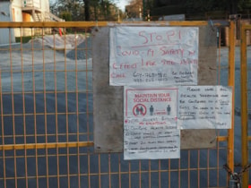
- Photograph of signs attached to security fencing outside the closed Schou Education Centre on Canada Way. Signs are handwritten and contain COVID-19 site safety protocols. Photograph was taken from Norfolk Street, facing south.
- Repository
- City of Burnaby Archives
- Date
- April 16, 2020
- Collection/Fonds
- Burnaby Photographic Society fonds
- Physical Description
- 1 photograph (tiff)
- Description Level
- Item
- Record No.
- 623-014
- Access Restriction
- No restrictions
- Reproduction Restriction
- No restrictions
- Accession Number
- 2020-10
- Scope and Content
- Photograph of signs attached to security fencing outside the closed Schou Education Centre on Canada Way. Signs are handwritten and contain COVID-19 site safety protocols. Photograph was taken from Norfolk Street, facing south.
- Media Type
- Photograph
- Photographer
- Damer, Eric
- Notes
- Transcribed title
- Geographic Access
- Gilmore Avenue
- Canada Way
- Street Address
- 4054 Norfolk Street
- Historic Neighbourhood
- Broadview (Historic Neighbourhood)
- Planning Study Area
- Cascade-Schou Area


![Douglas Road, [1897] (date of original), copied 1978 thumbnail](/media/hpo/_Data/_BVM_Images/1978/1978_0001_0001_001.jpg?width=280)
![Hill family, [189-] (date of original), copied 1986 thumbnail](/media/hpo/_Data/_Archives_Images/_Unrestricted/204/204-794.jpg?width=280)
![Living room at Bernard Hill's house, [189-] (date of original), copied 1977 thumbnail](/media/hpo/_Data/_BVM_Images/1977/1977_0123_0040_001.jpg?width=280)
