Narrow Results By
Creator
- Aitkenhead, May 1
- British Columbia Underwriters' Association 8
- Burnaby Village Museum 1
- Burnett, Geoffrey K. 1
- Burnett & McGugan, Engineers and Surveyors 1
- Damer, Eric 1
- Hawkshaw, Mabel Edith Honor McClean 4
- McAllister, Kenneth "Ken" 1
- McGeachie, Ivy Ashliegh 1
- Plan Department, British Columbia Insurance Underwriters' Association 8
- Stride, Charles Edgar 1
- Walker, Bea 1
Leonard Love
https://search.heritageburnaby.ca/link/museumdescription9861
- Repository
- Burnaby Village Museum
- Date
- 1899 (date of original)-2008
- Collection/Fonds
- Burnaby Village Museum fonds
- Description Level
- File
- Physical Description
- 2 cm of textual records
- Scope and Content
- File consists of vital statistical, biographical and historical information about Leonard Love and family. Records include copies of vital statistics, interview notes, a newspaper clipping on the BC Society of Model Engineers at BVM, correspondence from descendents of Leonard Love and their memori…
- Repository
- Burnaby Village Museum
- Collection/Fonds
- Burnaby Village Museum fonds
- Series
- Jesse Love farmhouse series
- Subseries
- Love farmhouse research files subseries
- Description Level
- File
- Physical Description
- 2 cm of textual records
- Scope and Content
- File consists of vital statistical, biographical and historical information about Leonard Love and family. Records include copies of vital statistics, interview notes, a newspaper clipping on the BC Society of Model Engineers at BVM, correspondence from descendents of Leonard Love and their memories of the Love family and time spent in the farmhouse and an obituary for Gordon Wesley Love. Leonard Love was born in 1899, married Jenny Kennedy in 1922 and is the son of Jesse Love and Martha Love (nee Leonard).
- Names
- Love, John Leonard
- Accession Code
- BV018.41.72
- Access Restriction
- Subject to FIPPA
- Reproduction Restriction
- Reproductions subject to FIPPA
- Date
- 1899 (date of original)-2008
- Media Type
- Textual Record
- Notes
- Title based on content of file
Letter re surveying of Lots 9, 54 (or 55) 106, and 107
https://search.heritageburnaby.ca/link/museumdescription11145
- Repository
- Burnaby Village Museum
- Date
- Dec. 13, 1927
- Collection/Fonds
- Ronald G. Scobbie collection
- Description Level
- File
- Physical Description
- 3 p. of textual records
- Scope and Content
- File consists of a typewritten letter dated December 13th, 1927 to "R. Newman, Esq., C.M.C. Corp. of Coquitlam, Maillardville, B.C." "Re. Lots 9, 54 (or 55) 106, and 107, Group 1, New Westminster District" from G.K. Burnett, B.C.L.S.
- Repository
- Burnaby Village Museum
- Collection/Fonds
- Ronald G. Scobbie collection
- Description Level
- File
- Physical Description
- 3 p. of textual records
- Scope and Content
- File consists of a typewritten letter dated December 13th, 1927 to "R. Newman, Esq., C.M.C. Corp. of Coquitlam, Maillardville, B.C." "Re. Lots 9, 54 (or 55) 106, and 107, Group 1, New Westminster District" from G.K. Burnett, B.C.L.S.
- Creator
- Burnett, Geoffrey K.
- Accession Code
- BV003.83.24
- Access Restriction
- No restrictions
- Reproduction Restriction
- No known restrictions
- Date
- Dec. 13, 1927
- Media Type
- Textual Record
- Notes
- Title based on contents of item
Letter re survey of District Lots 9, 55, 106 & 107 Group 1, New Westminster District
https://search.heritageburnaby.ca/link/museumdescription11154
- Repository
- Burnaby Village Museum
- Date
- 1927
- Collection/Fonds
- Ronald G. Scobbie collection
- Description Level
- File
- Physical Description
- 4 p. of textual records
- Scope and Content
- File consists of two typewritten letters. A three page carbon copy from Burnett & McGugan, dated 16th April 1927 Re: "DL 9-54-106-107, Gp. 1" is addressed to "R. Newman, Esq., / Corporation of Coquitlam, / Maillardville, BC". One page letter dated September 14th, 1927, includes the letterhead of "C…
- Repository
- Burnaby Village Museum
- Collection/Fonds
- Ronald G. Scobbie collection
- Description Level
- File
- Physical Description
- 4 p. of textual records
- Scope and Content
- File consists of two typewritten letters. A three page carbon copy from Burnett & McGugan, dated 16th April 1927 Re: "DL 9-54-106-107, Gp. 1" is addressed to "R. Newman, Esq., / Corporation of Coquitlam, / Maillardville, BC". One page letter dated September 14th, 1927, includes the letterhead of "Corporation of the District of Coquitlam / Muncipal Hall / Maillardville, BC" is addressed to "Messrs. Burnett & McGugan, / Engineers..." regarding a request for a "preliminary survey of District Lots 9, 55, 106 & 107". The letter is signed by Clerk "Hobart Newman".
- Accession Code
- BV003.83.33
- Access Restriction
- No restrictions
- Reproduction Restriction
- No known restrictions
- Date
- 1927
- Media Type
- Textual Record
- Notes
- Title based on contents of file
- Note in pencil on letter dated April 16, 1927 reads: "File under & Index / {DL 9, 54, 106, 107} Group 1"
- Note in pencil on verso of letter dated September 14th, 1927 reads: "Env. 3468"
Love farmhouse land and tax records
https://search.heritageburnaby.ca/link/museumdescription10022
- Repository
- Burnaby Village Museum
- Date
- 1891-1982 (date of originals), copied [ca.1988]
- Collection/Fonds
- Burnaby Village Museum fonds
- Description Level
- File
- Physical Description
- 1 folder of textual records
- Scope and Content
- File consists of photocopies and notes of historical information regarding the land ownership of the Jesse Love farmhouse and title of Block 1 and Lots 53 and 54 of District Lot 25 in Burnaby. Records include copies from a land title search done through the New Westminster Land Title Office in 1988…
- Repository
- Burnaby Village Museum
- Collection/Fonds
- Burnaby Village Museum fonds
- Series
- Jesse Love farmhouse series
- Subseries
- Love farmhouse research files subseries
- Description Level
- File
- Physical Description
- 1 folder of textual records
- Scope and Content
- File consists of photocopies and notes of historical information regarding the land ownership of the Jesse Love farmhouse and title of Block 1 and Lots 53 and 54 of District Lot 25 in Burnaby. Records include copies from a land title search done through the New Westminster Land Title Office in 1988 which covers ownership between 1928-1988; copy of Corporation of District of Burnaby By-Law 217 (1916) - "To confirm the purchase of and to reconvey a portion of District Lots 25 and 88..." ; copies of pages from Assessment Rolls between 1892 to 1904 ; copy of Land Sale Agreement from J.C Armstrong to Jesse Love, Oct. 6th, 1893; copies of notes from "Charge Book" Feb. 10, 1894 as well as copies of subdivision plans of DL 25.
- Accession Code
- BV018.41.1116
- Access Restriction
- Subject to FIPPA
- Reproduction Restriction
- Reproductions subject to FIPPA
- Date
- 1891-1982 (date of originals), copied [ca.1988]
- Media Type
- Textual Record
- Notes
- Title based on content of file
Martha Dorothy Brandrith (nee Love)
https://search.heritageburnaby.ca/link/museumdescription9855
- Repository
- Burnaby Village Museum
- Date
- 1920 (date of original)-[1998]
- Collection/Fonds
- Burnaby Village Museum fonds
- Description Level
- File
- Physical Description
- 1 cm of textual records
- Scope and Content
- File consists of copies of biographical and vital statistic information about Martha Dorothy (Dot) Brandrith (nee Love).
- Repository
- Burnaby Village Museum
- Collection/Fonds
- Burnaby Village Museum fonds
- Series
- Jesse Love farmhouse series
- Subseries
- Love farmhouse research files subseries
- Description Level
- File
- Physical Description
- 1 cm of textual records
- Scope and Content
- File consists of copies of biographical and vital statistic information about Martha Dorothy (Dot) Brandrith (nee Love).
- Accession Code
- BV018.41.66
- Access Restriction
- Subject to FIPPA
- Reproduction Restriction
- Reproductions subject to FIPPA
- Date
- 1920 (date of original)-[1998]
- Media Type
- Textual Record
- Notes
- Title based on content of file
Martha Love
https://search.heritageburnaby.ca/link/museumdescription9865
- Repository
- Burnaby Village Museum
- Date
- 1920 (date of original), copied [1998]
- Collection/Fonds
- Burnaby Village Museum fonds
- Description Level
- File
- Physical Description
- 2 p. of textual records
- Scope and Content
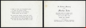
- File consists of copies of an obituary and In Memoriam card for Martha Love (nee Leonard).
- Repository
- Burnaby Village Museum
- Collection/Fonds
- Burnaby Village Museum fonds
- Series
- Jesse Love farmhouse series
- Subseries
- Love farmhouse research files subseries
- Description Level
- File
- Physical Description
- 2 p. of textual records
- Scope and Content
- File consists of copies of an obituary and In Memoriam card for Martha Love (nee Leonard).
- Accession Code
- BV018.41.76
- Access Restriction
- Subject to FIPPA
- Reproduction Restriction
- Reproductions subject to FIPPA
- Date
- 1920 (date of original), copied [1998]
- Media Type
- Textual Record
- Scan Date
- 2019-05-21
- Notes
- Title based on content of file
![May Aikenhead Scrapbook, [1936-1940] (date of original), copied 2016 thumbnail](/media/hpo/_Data/_BVM_Images/2015/2015_0035_0326_folded.jpg?width=280)
May Aikenhead Scrapbook
https://search.heritageburnaby.ca/link/museumdescription9664
- Repository
- Burnaby Village Museum
- Date
- [1936-1940] (date of original), copied 2016
- Collection/Fonds
- Burnaby Girl Guides fonds
- Description Level
- File
- Physical Description
- 1 scrapbook (2 digital files : col. (pdfs) + 75 photographs : col. (tiffs))
- Scope and Content
- File consists of images of a scrapbook of sixty pages of pasted copies of newspaper clippings of the "Girl Guide News" column, dating between January 3, 1936 and January 18, 1940 . The scrapbook also contains pasted copies of photographs and illustrations of the British Royal Family, newspaper clip…
- Repository
- Burnaby Village Museum
- Collection/Fonds
- Burnaby Girl Guides fonds
- Description Level
- File
- Physical Description
- 1 scrapbook (2 digital files : col. (pdfs) + 75 photographs : col. (tiffs))
- Material Details
- Pre-printed design on front cover of scrapbook reads: “SCRAP / BOOK", with red, green, and black illustrations of scissors and a bottle of paste.
- White, rectangular paper label adhered to upper right corner of cover reads: "FORGET-ME-NOT PATROL / SCRAP BOOK" in red ink.
- More recent white, rectangular paper label adhered to upper right corner of cover reads: "From: May Aikenhead / 97 years old / Burnaby Royal Trefoil / 2001".
- Scope and Content
- File consists of images of a scrapbook of sixty pages of pasted copies of newspaper clippings of the "Girl Guide News" column, dating between January 3, 1936 and January 18, 1940 . The scrapbook also contains pasted copies of photographs and illustrations of the British Royal Family, newspaper clippings about the death of King George V, the not-to-be coronation of Edward VIII, and the eventual coronation of King George IV. Miscellaneous general clippings and photographs about Girl Guides and Scouts are also present.
- Accession Code
- BV015.35.326
- Access Restriction
- No restrictions
- Reproduction Restriction
- No known restrictions
- Date
- [1936-1940] (date of original), copied 2016
- Media Type
- Photograph
- Textual Record
- Notes
- Title based on contents of scrapbook
- Selected ephemera from scrapbook are described at as artifact (BV015.35.328 to BV015.35.330)
Images
![May Aikenhead Scrapbook, [1936-1940] (date of original), copied 2016 thumbnail](/media/hpo/_Data/_BVM_Images/2015/2015_0035_0326_folded.jpg)
Documents
![May Aikenhead Scrapbook, [1935-1940] (date of original), copied 2016 thumbnail](/media/hpo/_Data/_BVM_Images/2015/2015_0035_0327_folded.jpg?width=280)
May Aikenhead Scrapbook
https://search.heritageburnaby.ca/link/museumdescription9665
- Repository
- Burnaby Village Museum
- Date
- [1935-1940] (date of original), copied 2016
- Collection/Fonds
- Burnaby Girl Guides fonds
- Description Level
- File
- Physical Description
- 1 scrapbook (2 digital files : col. (pdfs) + 77 photographs : col. (tiffs))
- Scope and Content
- File consists of images of a scrapbook of sixty-six pages of pasted copies of the "Girl Guide News" column, dating between January 3, 1936 and January 18, 1937. The scrapbook also contains pasted copies of photographs and illustrations of Canadian Governor General John Buchan, the British Royal Fam…
- Repository
- Burnaby Village Museum
- Collection/Fonds
- Burnaby Girl Guides fonds
- Description Level
- File
- Physical Description
- 1 scrapbook (2 digital files : col. (pdfs) + 77 photographs : col. (tiffs))
- Material Details
- Pre-printed design in black on front cover of scrapbook reads: “SCRAPS".
- White, rectangular paper label adhered to upper right corner of cover reads: "From: May Aikenhead / 97 years old / Burnaby Royal Trefoil / 2001 / (1936)".
- Scope and Content
- File consists of images of a scrapbook of sixty-six pages of pasted copies of the "Girl Guide News" column, dating between January 3, 1936 and January 18, 1937. The scrapbook also contains pasted copies of photographs and illustrations of Canadian Governor General John Buchan, the British Royal Family, the death of King George V, the not-to-be coronation of Edward VIII, and the eventual coronation of King George IV. Miscellaneous general clippings and photographs about Girl Guides and Scouts are also present.
- Accession Code
- BV015.35.327
- Access Restriction
- No restrictions
- Reproduction Restriction
- No known restrictions
- Date
- [1935-1940] (date of original), copied 2016
- Media Type
- Photograph
- Textual Record
- Notes
- Title based on contents of scrapbook
Images
![May Aikenhead Scrapbook, [1935-1940] (date of original), copied 2016 thumbnail](/media/hpo/_Data/_BVM_Images/2015/2015_0035_0327_folded.jpg)
Documents
Memorial cards for Martha Love
https://search.heritageburnaby.ca/link/museumdescription10093
- Repository
- Burnaby Village Museum
- Date
- 1920
- Collection/Fonds
- Love family fonds
- Description Level
- File
- Physical Description
- 1 folder of textual records
- Scope and Content
- File consists of a three memorial cards for Martha Love which read: "In Loving Memory / OF / Martha Love / BELOVED WIFE OF JESSE LOVE / CUMBERLAND ROAD, BURNABY, B.C. / Died August 24RD. 1920 / AGED 62 YEARS / INTERRED IN I.O.O.F. CEMETERY, SAPPERTON / NEW WESTMINSTER, B.C., AUGUST 26TH, 1920". A s…
- Repository
- Burnaby Village Museum
- Collection/Fonds
- Love family fonds
- Description Level
- File
- Physical Description
- 1 folder of textual records
- Scope and Content
- File consists of a three memorial cards for Martha Love which read: "In Loving Memory / OF / Martha Love / BELOVED WIFE OF JESSE LOVE / CUMBERLAND ROAD, BURNABY, B.C. / Died August 24RD. 1920 / AGED 62 YEARS / INTERRED IN I.O.O.F. CEMETERY, SAPPERTON / NEW WESTMINSTER, B.C., AUGUST 26TH, 1920". A short, religious poem is printed on the inside face of the card. "IN LOVING / MEMORY" with an image of a rose is printed on the front face of the card.
- History
- See extensive history of Love Family and Love farmhouse located at Burnaby Village Museum.
- Accession Code
- BV012.31.25
- Access Restriction
- No restrictions
- Reproduction Restriction
- No known restrictions
- Date
- 1920
- Media Type
- Textual Record
- Scan Resolution
- 600
- Scan Date
- 7-May-20
- Scale
- 100
- Notes
- Title based on content of file
Images

Moving notices for Stewart's Cartage and Fuel Supply
https://search.heritageburnaby.ca/link/museumdescription9726
- Repository
- Burnaby Village Museum
- Date
- 1921-1922, 1924-1925
- Collection/Fonds
- Hugh H. Stewart fonds
- Description Level
- File
- Physical Description
- 1 file of textual records
- Scope and Content
- File consists of five numbered cards announcing "Our Business is Moving" from "Stewart's Cartage and Fuel Supply at 3870 Hastings Street, Vancouver, B.C". (this address is part of the Municipality of Burnaby).
- Repository
- Burnaby Village Museum
- Collection/Fonds
- Hugh H. Stewart fonds
- Description Level
- File
- Physical Description
- 1 file of textual records
- Scope and Content
- File consists of five numbered cards announcing "Our Business is Moving" from "Stewart's Cartage and Fuel Supply at 3870 Hastings Street, Vancouver, B.C". (this address is part of the Municipality of Burnaby).
- Accession Code
- HV979.50.249
- Access Restriction
- No restrictions
- Reproduction Restriction
- No known restrictions
- Date
- 1921-1922, 1924-1925
- Media Type
- Textual Record
- Notes
- Title based on contents of file

Municipality of Burnaby - Volume XV and Volume XVIII
https://search.heritageburnaby.ca/link/museumdescription8680
- Repository
- Burnaby Village Museum
- Date
- May 1927
- Collection/Fonds
- Burnaby Village Museum Map collection
- Description Level
- File
- Physical Description
- 4 plans on 4 sheets : col. lithographic prints ; 63.5 x 53.5 cm folded to 53 x 31.5 cm
- Scope and Content
- File consists of four pages of plans removed from a bound book containing a series of fire insurance plans of the Municipality of Burnaby. The first two pages are numbered "A" and "B" and are key plans from "GREATER VANCOUVER B.C. / VOLUME XV / Surveyed _ May 1927 / MUNICIPALITY OF / BURNABY", "PLA…
- Repository
- Burnaby Village Museum
- Collection/Fonds
- Burnaby Village Museum Map collection
- Description Level
- File
- Physical Description
- 4 plans on 4 sheets : col. lithographic prints ; 63.5 x 53.5 cm folded to 53 x 31.5 cm
- Material Details
- Scales [1:1200] and [1:6000]
- Scope and Content
- File consists of four pages of plans removed from a bound book containing a series of fire insurance plans of the Municipality of Burnaby. The first two pages are numbered "A" and "B" and are key plans from "GREATER VANCOUVER B.C. / VOLUME XV / Surveyed _ May 1927 / MUNICIPALITY OF / BURNABY", "PLAN DEPT. FIRE BRANCH _ B.C. INSURANCE UNDERWRITERS ASSN.". Key Plan "B" covers plans: 1505; 1506; 1512 to 1516; 1540 to 1544; 1550 to 1557 and District Lots: 129 to 132; 135 to 138; 205 to 208 and 215 to 218. Key Plan "A" covers plans: 1501 to 1504; 1507 to 1511; 1517 to 1525; 1531 to 1539; 1545 to 1550 and District Lots: 116 to 127 and 186 to 189. Plan "1806" is part of "GREATER VANCOUVER B.C. / VOLUME XVIII / Municipality of Burnaby / May, 1927" and covers District Lot 153. Plan "1807" is from "GREATER VANCOUVER B.C. / VOLUME XVIII / Municipality of Burnaby / May, 1927" and covers District Lots: 99,149 and 152.
- Responsibility
- British Columbia Underwriters' Association
- Accession Code
- HV972.111.2
- Access Restriction
- No restrictions
- Reproduction Restriction
- May be restricted by third party rights
- Date
- May 1927
- Media Type
- Cartographic Material
- Historic Neighbourhood
- Vancouver Heights (Historic Neighbourhood)
- Lochdale (Historic Neighbourhood)
- Capitol Hill (Historic Neighbourhood)
- Central Park (Historic Neighbourhood)
- Alta Vista (Historic Neighbourhood)
- Planning Study Area
- Burnaby Heights Area
- Sperling-Broadway Area
- Lochdale Area
- Parkcrest-Aubrey Area
- Westridge Area
- Willingdon Heights Area
- Capitol Hill Area
- Maywood Area
- Marlborough Area
- Scan Resolution
- 400
- Scan Date
- 2021-11-18
- Notes
- Title based on content of plans
- Scales are measured 1 inch = 100 feet and 1 inch = 500 feet
- See also BV987.1.70d for revised versions of plans
Zoomable Images


Municipality of Burnaby - Volume XV and Volume XVIII
https://search.heritageburnaby.ca/link/museumdescription8681
- Repository
- Burnaby Village Museum
- Date
- May 1927
- Collection/Fonds
- Burnaby Village Museum Map collection
- Description Level
- File
- Physical Description
- 4 plans on 4 sheets : col. lithographic prints, ms. annotations in blue ink ; 63.5 x 53.5 cm folded to 53 x 31.5 cm
- Scope and Content
- File consists of four pages of plans removed from a bound book containing a series of fire insurance plans of the Municipality of Burnaby. Plan "1507" and plan "1517" are from "GREATER VANCOUVER B.C. / VOLUME XV / Municipality of Burnaby / May, 1927". Plan "1507" covers District Lot 186 and plan "1…
- Repository
- Burnaby Village Museum
- Collection/Fonds
- Burnaby Village Museum Map collection
- Description Level
- File
- Physical Description
- 4 plans on 4 sheets : col. lithographic prints, ms. annotations in blue ink ; 63.5 x 53.5 cm folded to 53 x 31.5 cm
- Material Details
- Scale [1:600] and [1:1200]
- Scope and Content
- File consists of four pages of plans removed from a bound book containing a series of fire insurance plans of the Municipality of Burnaby. Plan "1507" and plan "1517" are from "GREATER VANCOUVER B.C. / VOLUME XV / Municipality of Burnaby / May, 1927". Plan "1507" covers District Lot 186 and plan "1517" covers District Lot 116. Plan "1804" and plan "1805" are from "GREATER VANCOUVER B.C. / VOLUME XVIII / Municipality of Burnaby / May, 1927". Plans "1804" and "1805" cover District Lot 153.
- Responsibility
- British Columbia Underwriters' Association
- Accession Code
- HV972.111.3
- Access Restriction
- No restrictions
- Reproduction Restriction
- May be restricted by third party rights
- Date
- May 1927
- Media Type
- Cartographic Material
- Historic Neighbourhood
- Central Park (Historic Neighbourhood)
- Vancouver Heights (Historic Neighbourhood)
- Planning Study Area
- Maywood Area
- Willingdon Heights Area
- Scan Resolution
- 400
- Scan Date
- 2021-11-18
- Notes
- Title based on content of plans
- See also BV987.1.70d for revised versions of plans
- Scale is measured 1 inch = 100 feet
Images


![Municipality of Burnaby - Volume XV and Volume XVIII, 1927-[1940] thumbnail](/media/hpo/_Data/_BVM_Artifacts/1972/1972_0111_0004_003.jpg?width=280)
Municipality of Burnaby - Volume XV and Volume XVIII
https://search.heritageburnaby.ca/link/museumdescription8682
- Repository
- Burnaby Village Museum
- Date
- 1927-[1940]
- Collection/Fonds
- Burnaby Village Museum Map collection
- Description Level
- File
- Physical Description
- 4 plans on 4 sheets: col. lithographic prints ; 63.5 x 53.5 cm folded to 53 x 31.5 cm
- Scope and Content
- File consists of four pages of plans removed from a bound book containing a series of fire insurance plans of the Municipality of Burnaby. Plan "1518" and "1519" are from "GREATER VANCOUVER B.C. / VOLUME XV / Municipality of Burnaby / May, 1927". Plan "1518" covers District Lot 116 and Plan "1519"…
- Repository
- Burnaby Village Museum
- Collection/Fonds
- Burnaby Village Museum Map collection
- Description Level
- File
- Physical Description
- 4 plans on 4 sheets: col. lithographic prints ; 63.5 x 53.5 cm folded to 53 x 31.5 cm
- Material Details
- Scale [1:600]
- Scope and Content
- File consists of four pages of plans removed from a bound book containing a series of fire insurance plans of the Municipality of Burnaby. Plan "1518" and "1519" are from "GREATER VANCOUVER B.C. / VOLUME XV / Municipality of Burnaby / May, 1927". Plan "1518" covers District Lot 116 and Plan "1519" covers District Lot 121. Plan "1802" and plan "1803" are from "GREATER VANCOUVER B.C. / VOLUME XVIII / Municipality of Burnaby / May, 1927". Both plans "1802" and "1803" cover District Lot 153.
- Responsibility
- British Columbia Underwriters' Association
- Accession Code
- HV972.111.4
- Access Restriction
- No restrictions
- Reproduction Restriction
- May be restricted by third party rights
- Date
- 1927-[1940]
- Media Type
- Cartographic Material
- Historic Neighbourhood
- Vancouver Heights (Historic Neighbourhood)
- Central Park (Historic Neighbourhood)
- Planning Study Area
- Willingdon Heights Area
- Marlborough Area
- Scan Resolution
- 400
- Scan Date
- 2021-11-18
- Notes
- Title based on content of plans
- See also BV987.1.70d for revised versions of plans
- Scale is measured 1 inch = 50 feet
- Contact Burnaby Village Museum to access plans 1518 and 1519 (these plans have revisions on top - date of revisions is uncertain)
Images
![Municipality of Burnaby - Volume XV and Volume XVIII, 1927-[1940] thumbnail](/media/hpo/_Data/_BVM_Artifacts/1972/1972_0111_0004_003.jpg)


Municipality of Burnaby- Volume XV and Volume XVIII
https://search.heritageburnaby.ca/link/museumdescription8686
- Repository
- Burnaby Village Museum
- Date
- May 1927
- Collection/Fonds
- Burnaby Village Museum Map collection
- Description Level
- File
- Physical Description
- 4 plans on 4 sheets : col. lithographic prints ; 63.5 x 53.5 cm folded to 53 x 31.5 cm
- Scope and Content
- File consists of four pages of plans removed from a bound book containing a series of fire insurance plans of the Municipality of Burnaby. Plan "1520" is part of "GREATER VANCOUVER B.C. / VOLUME XV / Municipality of Burnaby / May 1927" and covers District Lots: 121 and 187. Plann "1521" is part of …
- Repository
- Burnaby Village Museum
- Collection/Fonds
- Burnaby Village Museum Map collection
- Description Level
- File
- Physical Description
- 4 plans on 4 sheets : col. lithographic prints ; 63.5 x 53.5 cm folded to 53 x 31.5 cm
- Material Details
- Scale [1:600] and [1:1200]
- Scope and Content
- File consists of four pages of plans removed from a bound book containing a series of fire insurance plans of the Municipality of Burnaby. Plan "1520" is part of "GREATER VANCOUVER B.C. / VOLUME XV / Municipality of Burnaby / May 1927" and covers District Lots: 121 and 187. Plann "1521" is part of "GREATER VANCOUVER B.C. / VOLUME XV / Municipality of Burnaby / May 1927" and covers District Lots: 121 and 187. Key plan "H" reads: "GREATER VANCOUVER B.C. / VOLUME XVIII / Surveyed _ May 1927 / MUNICIPALITY OF / BURNABY" and covers plans: 1813 to 1822; 1824 to 1832; 1839; 1840; 1853 to 1865 and District Lots: 28; 30; 53; 90 to 93; 95 to 97; 155a; 155b; 155c; 159; 160; 171 to 173. Plan "1801" is part of "GREATER VANCOUVER B.C. / VOLUME XVIII / Municipality of Burnaby / May 1927" and covers District Lot 153.
- Responsibility
- British Columbia Underwriters' Association
- Accession Code
- HV972.111.8
- Access Restriction
- No restrictions
- Reproduction Restriction
- May be restricted by third party rights
- Date
- May 1927
- Media Type
- Cartographic Material
- Historic Neighbourhood
- Fraser Arm (Historic Neighbourhood)
- Vancouver Heights (Historic Neighbourhood)
- East Burnaby (Historic Neighbourhood)
- Edmonds (Historic Neighbourhood)
- Planning Study Area
- Marlborough Area
- Kingsway-Beresford Area
- Windsor Area
- Big Bend Area
- Clinton-Glenwood Area
- Burnaby Heights Area
- Edmonds Area
- Stride Avenue Area
- Scan Resolution
- 400
- Scan Date
- 2021-11-18
- Notes
- Title based on content of plans
- See also BV987.1.70d for revised versions of plans
- Scale is measured 1 inch = 500 feet
Zoomable Images


Municipality of Burnaby - Volume XVI and Volume XVII
https://search.heritageburnaby.ca/link/museumdescription8684
- Repository
- Burnaby Village Museum
- Date
- May 1927
- Collection/Fonds
- Burnaby Village Museum Map collection
- Description Level
- File
- Physical Description
- 4 plans on 4 sheets : col. lithographic prints ; 63.5 x 53.5 cm folded to 53 x 31.5 cm
- Scope and Content
- File consists of four pages of plans removed from a bound book containing a series of fire insurance plans of the Municipality of Burnaby. Page "D" is titled: "GREATER VANCOUVER B.C. / VOLUME XVI / Surveyed _ May 1927 / MUNICIPALITY OF / BURNABY / PLAN DEPT. FIRE BRANCH _ B.C. INSURANCE UNDERWRITE…
- Repository
- Burnaby Village Museum
- Collection/Fonds
- Burnaby Village Museum Map collection
- Description Level
- File
- Physical Description
- 4 plans on 4 sheets : col. lithographic prints ; 63.5 x 53.5 cm folded to 53 x 31.5 cm
- Material Details
- Scale [1:1200] and [1:6000]
- Scope and Content
- File consists of four pages of plans removed from a bound book containing a series of fire insurance plans of the Municipality of Burnaby. Page "D" is titled: "GREATER VANCOUVER B.C. / VOLUME XVI / Surveyed _ May 1927 / MUNICIPALITY OF / BURNABY / PLAN DEPT. FIRE BRANCH _ B.C. INSURANCE UNDERWRITERS ASSN." / KEY PLAN". Plans covered in this "Key Plan" are numbered 1601 to 1626, 1632 and 1651 covering District Lots: 15; 31; 100 to 102; 114; 141 to 144; 147 and 148; 209 to 214. Plan "E" is part of "GREATER VANCOUVER B.C. / VOLUME XVII / Municipality of Burnaby / May 1927" and covers plans: 1701 to 1705; 1711 to 1715; 1723 to 1727; 1729 to 1733; 1737 to 1742 and District Lots: 68 to 74; 80 to 84; 32 to 35 and 38 to 39. Plan marked "F" is a key plan titled: "GREATER VANCOUVER B.C. / VOLUME XVII / Surveyed _ May 1927 / MUNICIPALITY OF / BURNABY and covers plans: 1706 to 1710; 1716 to 1722; 1734 and 1735; 1743 to 1752 and District Lots: 42 to 44; 59; 75 to 80; 83 to 87; 89 to 93 and 130. Plan "1729" is part of "GREATER VANCOUVER B.C. / VOLUME XVII / Municipality of Burnaby / May 1927" and covers District Lots 34 and 35.
- Responsibility
- British Columbia Underwriters' Association
- Accession Code
- HV972.111.6
- Access Restriction
- No restrictions
- Reproduction Restriction
- May be restricted by third party rights
- Date
- May 1927
- Media Type
- Cartographic Material
- Historic Neighbourhood
- Barnet (Historic Neighbourhood)
- Burquitlam (Historic Neighbourhood)
- Central Park (Historic Neighbourhood)
- Burnaby Lake (Historic Neighbourhood)
- Broadview (Historic Neighbourhood)
- Planning Study Area
- Burnaby Mountain Area
- Lyndhurst Area
- Lake City Area
- Cascade-Schou Area
- Garden Village Area
- Douglas-Gilpin Area
- Oakalla Area
- Scan Resolution
- 400
- Scan Date
- 2021-11-18
- Notes
- Title based on content of plans
- See also BV987.1.70d for revised versions of plans
- Scale is measured 1 inch = 500 feet
Zoomable Images


Municipality of Burnaby - Volume XVIII
https://search.heritageburnaby.ca/link/museumdescription8687
- Repository
- Burnaby Village Museum
- Date
- May 1927
- Collection/Fonds
- Burnaby Village Museum Map collection
- Description Level
- File
- Physical Description
- 2 plans on 2 sheets : col. lithographic prints; 63.5 x 53.5 cm folded to 53 x 31.5 cm
- Scope and Content
- File consists of two pages of plans removed from a bound book containing a series of fire insurance plans of the Municipality of Burnaby. Plan "1819" and Plan "1820 are part of "GREATER VANCOUVER B.C. / VOLUME XVIII / Municipality of Burnaby / May 1927. Plan "1819" covers District Lot 95 and plan …
- Repository
- Burnaby Village Museum
- Collection/Fonds
- Burnaby Village Museum Map collection
- Description Level
- File
- Physical Description
- 2 plans on 2 sheets : col. lithographic prints; 63.5 x 53.5 cm folded to 53 x 31.5 cm
- Material Details
- Scales [1:600]
- Scope and Content
- File consists of two pages of plans removed from a bound book containing a series of fire insurance plans of the Municipality of Burnaby. Plan "1819" and Plan "1820 are part of "GREATER VANCOUVER B.C. / VOLUME XVIII / Municipality of Burnaby / May 1927. Plan "1819" covers District Lot 95 and plan "1820" covers District Lots 30 and 95.
- Responsibility
- British Columbia Underwriters' Association
- Accession Code
- HV972.111.38
- Access Restriction
- No restrictions
- Reproduction Restriction
- May be restricted by third party rights
- Date
- May 1927
- Media Type
- Cartographic Material
- Historic Neighbourhood
- Edmonds (Historic Neighbourhood)
- Highland Park (Historic Neighbourhood)
- Planning Study Area
- Stride Hill Area
- Kingsway-Beresford Area
- Scan Resolution
- 400
- Scan Date
- 2021-11-18
- Notes
- Title based on content of plans
- Scales are measured 1 inch = 50 feet
- See also BV987.1.70d for revised versions of plans
Images


Municipality of Burnaby - Volume XVIII and Volume XIX
https://search.heritageburnaby.ca/link/museumdescription8683
- Repository
- Burnaby Village Museum
- Date
- May 1927
- Collection/Fonds
- Burnaby Village Museum Map collection
- Description Level
- File
- Physical Description
- 2 plans on 2 sheets : col. lithographic prints ; 63.5 x 53.5 cm folded to 53 x 31.5 cm
- Scope and Content
- File consists of two pages of plans removed from a bound book containing a series of fire insurance plans of the Municipality of Burnaby. Plan "1832" is from "GREATER VANCOUVER B.C. / VOLUME XVIII / Municipality of Burnaby / May, 1927" and covers District Lots: 98 and 28. Plan "K" is part of a key …
- Repository
- Burnaby Village Museum
- Collection/Fonds
- Burnaby Village Museum Map collection
- Description Level
- File
- Physical Description
- 2 plans on 2 sheets : col. lithographic prints ; 63.5 x 53.5 cm folded to 53 x 31.5 cm
- Material Details
- Scale [1:1200] to [1:6000]
- Scope and Content
- File consists of two pages of plans removed from a bound book containing a series of fire insurance plans of the Municipality of Burnaby. Plan "1832" is from "GREATER VANCOUVER B.C. / VOLUME XVIII / Municipality of Burnaby / May, 1927" and covers District Lots: 98 and 28. Plan "K" is part of a key plan "GREATER VANCOUVER B.C. / Surveyed VOLUME XIX May 1927 / MUNICIPALITY OF / BURNABY / PLAN DEPT. British Columbia Ins. Underwriters Association / FIRE BRANCH / KEY PLAN", "Scale 500 FT = 1 INCH / FOR REPORT SEE VOL. XV" covering plans: 1901 to 1914 and District Lots: 161; 164 to 167; 155c; 155; 172 and 173.
- Responsibility
- British Columbia Underwriters' Association
- Accession Code
- HV972.111.5
- Access Restriction
- No restrictions
- Reproduction Restriction
- May be restricted by third party rights
- Date
- May 1927
- Media Type
- Cartographic Material
- Historic Neighbourhood
- East Burnaby (Historic Neighbourhood)
- Central Park (Historic Neighbourhood)
- Fraser Arm (Historic Neighbourhood)
- Alta Vista (Historic Neighbourhood)
- Planning Study Area
- Windsor Area
- Marlborough Area
- Second Street Area
- Big Bend Area
- Sussex-Nelson Area
- Scan Resolution
- 400
- Scan Date
- 2021-11-18
- Notes
- Title based on content of plans
- See also BV987.1.70d for revised versions of plans
- Scale is measured 1 inch = 500 feet
Zoomable Images


Municipality of Burnaby - Volume XV, Volume XVI, Volume XVII, Volume XVIII
https://search.heritageburnaby.ca/link/museumdescription8685
- Repository
- Burnaby Village Museum
- Date
- May 1927
- Collection/Fonds
- Burnaby Village Museum Map collection
- Description Level
- File
- Physical Description
- 4 plans on 4 sheets : col. lithographic prints ; 63.5 x 53.5 cm folded to 53 x 31.5 cm
- Scope and Content
- File consists of four pages of plans removed from a bound book containing a series of fire insurance plans of the Municipality of Burnaby. Plan "1531" is part of "GREATER VANCOUVER B.C. / VOLUME XV / Municipality of Burnaby / May 1927" and covers District Lots: 116 and 117. Key Plan "C" is part of …
- Repository
- Burnaby Village Museum
- Collection/Fonds
- Burnaby Village Museum Map collection
- Description Level
- File
- Physical Description
- 4 plans on 4 sheets : col. lithographic prints ; 63.5 x 53.5 cm folded to 53 x 31.5 cm
- Material Details
- Scale [1:600] and [1:1200]
- Scope and Content
- File consists of four pages of plans removed from a bound book containing a series of fire insurance plans of the Municipality of Burnaby. Plan "1531" is part of "GREATER VANCOUVER B.C. / VOLUME XV / Municipality of Burnaby / May 1927" and covers District Lots: 116 and 117. Key Plan "C" is part of "GREATER VANCOUVER B.C. / VOLUME XVI / Municipality of Burnaby / May 1927" and covers plans 1623 to 1651 and District Lots: 1 and 2; 4; 6; 8; 10 to 14; 25; 27; 40; 56 to 58; 88 and 89. Plan "1738" is part of "GREATER VANCOUVER B.C. / VOLUME XVII / Municipality of Burnaby / May 1927" and covers District Lots: 34 and 35. Key plan "G" is part of "GREATER VANCOUVER B.C. / VOLUME XVIII / Municipality of Burnaby / May 1927" and covers plans: 1801 to 1813; 1823; 1824; 1833 to 1838; 1841 to 1853 and District Lots: 32; 93; 94; 97 to 99; 149; 150; 152; 155 to 159; 161 to 164.
- Responsibility
- British Columbia Underwriters' Association
- Accession Code
- HV972.111.7
- Access Restriction
- No restrictions
- Reproduction Restriction
- May be restricted by third party rights
- Date
- May 1927
- Media Type
- Cartographic Material
- Historic Neighbourhood
- Central Park (Historic Neighbourhood)
- Fraser Arm (Historic Neighbourhood)
- Alta Vista (Historic Neighbourhood)
- Broadview (Historic Neighbourhood)
- Vancouver Heights (Historic Neighbourhood)
- Burquitlam (Historic Neighbourhood)
- East Burnaby (Historic Neighbourhood)
- Edmonds (Historic Neighbourhood)
- Lozells (Historic Neighbourhood)
- Planning Study Area
- Clinton-Glenwood Area
- Marlborough Area
- Maywood Area
- Windsor Area
- Big Bend Area
- Garden Village Area
- Willingdon Heights Area
- West Central Valley Area
- Cariboo-Armstrong Area
- Lyndhurst Area
- Cameron Area
- Lake City Area
- Edmonds Area
- Second Street Area
- Sperling-Broadway Area
- Lakeview-Mayfield Area
- Scan Resolution
- 400
- Scan Date
- 2021-11-18
- Notes
- Title based on content of plans
- See also BV987.1.70d for revised versions of plans
- Scale is measured 1 inch = 500 feet
Zoomable Images

Municipality of Burnaby - Volume XV, Volume XVI, Volume XVII, Volume XVIII, May 1927
Zoom into Image
New biography - Boag Foundation
https://search.heritageburnaby.ca/link/museumdescription3645
- Repository
- Burnaby Village Museum
- Date
- 1933, 1993-2002
- Collection/Fonds
- Harold Edward Winch collection
- Description Level
- File
- Physical Description
- 1 folder of textual records
- Scope and Content
- File consists of records relating to the development of a biography of Harold Winch, including sympathy cards, correspondence, and memorials from Winch's death, as well as correspondence relating to Ron and Florence Riley's remembrances of Winch.
- Repository
- Burnaby Village Museum
- Collection/Fonds
- Harold Edward Winch collection
- Description Level
- File
- Physical Description
- 1 folder of textual records
- Scope and Content
- File consists of records relating to the development of a biography of Harold Winch, including sympathy cards, correspondence, and memorials from Winch's death, as well as correspondence relating to Ron and Florence Riley's remembrances of Winch.
- Names
- Winch, Harold Edward
- Accession Code
- BV013.12.2
- Date
- 1933, 1993-2002
- Media Type
- Textual Record
- Notes
- Title based on contents of file
Odd Fellows' Funeral aid and rental receipts
https://search.heritageburnaby.ca/link/museumdescription9753
- Repository
- Burnaby Village Museum
- Date
- 1914-1929
- Collection/Fonds
- Hugh H. Stewart fonds
- Description Level
- File
- Physical Description
- 1 file of textual records
- Scope and Content
- File consists "The Odd Fellow's Funeral Aid Association" receipts for monies received from "H.H. Stewart" in December 1, 1916, January 2, 1919, February 15, 1923 and 1925 along with a document from the "HEAD OFFICE OF THE / Odd Fellows' Funeral Aid Association / of British Columbia" dated March 1, …
- Repository
- Burnaby Village Museum
- Collection/Fonds
- Hugh H. Stewart fonds
- Description Level
- File
- Physical Description
- 1 file of textual records
- Scope and Content
- File consists "The Odd Fellow's Funeral Aid Association" receipts for monies received from "H.H. Stewart" in December 1, 1916, January 2, 1919, February 15, 1923 and 1925 along with a document from the "HEAD OFFICE OF THE / Odd Fellows' Funeral Aid Association / of British Columbia" dated March 1, 1929 regarding "Assessment No. 28" which includes a list of deceased members whose claims have been paid since June 1, 1928. The file also contains five rental receipts from "Vancouver Lodge No. 8, I.O.O.F." made out to H.H. Stewart for rent of Hastings Street and Cambie Street property in 1914.
- Names
- Stewart, Hugh Henry
- Accession Code
- HV979.50.262
- Access Restriction
- Restricted access
- Reproduction Restriction
- Reproductions subject to FIPPA
- Date
- 1914-1929
- Media Type
- Textual Record
- Notes
- Title based on content of file