Narrow Results By
Subject
- Accidents 11
- Accidents - Automobile Accidents 29
- Accidents - Train Accidents 23
- Adminstrative Groups - Committees 4
- Adornment - Jewelry 7
- Adornment - Lapel Pins 1
- Advertising Medium 10
- Advertising Medium - Flyer 3
- Advertising Medium - Poster 16
- Advertising Medium - Signs and Signboards 212
- Aerial Photographs 132
- Agricultural Tools and Equipment 22

Cigarette price sign inside of Canada Way Food Market
https://search.heritageburnaby.ca/link/museumdescription20349
- Repository
- Burnaby Village Museum
- Date
- 13 Jun. 2023
- Collection/Fonds
- Harry Toy fonds
- Description Level
- Item
- Physical Description
- 1 photograph (jpg) : col.
- Scope and Content
- Photograph of cigarette price display sign hanging from ceiling inside of the Canada Way Food Market located at 4694 Canada Way, Burnaby. Boxes are visible beneath the sign. The food market closed in 2010.
- Repository
- Burnaby Village Museum
- Collection/Fonds
- Harry Toy fonds
- Series
- Harry Toy photographs series
- Description Level
- Item
- Physical Description
- 1 photograph (jpg) : col.
- Scope and Content
- Photograph of cigarette price display sign hanging from ceiling inside of the Canada Way Food Market located at 4694 Canada Way, Burnaby. Boxes are visible beneath the sign. The food market closed in 2010.
- Subjects
- Buildings - Commercial - Stores
- Names
- Canada Way Food Market
- Geographic Access
- Canada Way
- Street Address
- 4694 Canada Way
- Accession Code
- BV023.25.1
- Access Restriction
- No restrictions
- Reproduction Restriction
- No known restrictions
- Date
- 13 Jun. 2023
- Media Type
- Photograph
- Related Material
- BV023.16.19 - Interview with Harry Toy, Beverley Babey and Christina Toy
- BV023.17.3 - Cigarette price display sign
- For associated artifacts from Canada Way Food Market see Accession BV023.17
- Scan Date
- 2023-06-13
- Photographer
- Petrusa, Kate
- Notes
- Title based on contents of photograph
- The sign was donated to the Burnaby Village Museum in 2023
Images


Canada Way Food Market and Toy residence
https://search.heritageburnaby.ca/link/museumdescription20350
- Repository
- Burnaby Village Museum
- Date
- 13 Jun. 2023
- Collection/Fonds
- Harry Toy fonds
- Description Level
- Item
- Physical Description
- 1 photograph (tiff) : col.
- Scope and Content
- Photograph of the exterior of Canada Way Food Market building and Toy family residence (above) located at 4694 Canada Way. Blue plastic food crates, store racks and car tires are in the parking area in front of the store. The food market closed in 2010.
- Repository
- Burnaby Village Museum
- Collection/Fonds
- Harry Toy fonds
- Series
- Harry Toy photographs series
- Description Level
- Item
- Physical Description
- 1 photograph (tiff) : col.
- Scope and Content
- Photograph of the exterior of Canada Way Food Market building and Toy family residence (above) located at 4694 Canada Way. Blue plastic food crates, store racks and car tires are in the parking area in front of the store. The food market closed in 2010.
- Subjects
- Buildings - Commercial - Stores
- Names
- Canada Way Food Market
- Geographic Access
- Canada Way
- Street Address
- 4694 Canada Way
- Accession Code
- BV023.25.2
- Access Restriction
- No restrictions
- Reproduction Restriction
- No known restrictions
- Date
- 13 Jun. 2023
- Media Type
- Photograph
- Related Material
- See also BV023.16.19 - Interview with Harry Toy, Beverley Babey and Christina Toy
- For associated artifacts from Canada Way Food Market see Accession BV023.17
- Scan Date
- 2023-06-13
- Photographer
- Petrusa, Kate
- Notes
- Title based on contents of photograph
Images


Imperial Apartment
https://search.heritageburnaby.ca/link/archivedescription98656
- Repository
- City of Burnaby Archives
- Date
- 2022
- Collection/Fonds
- Disappearing Burnaby collection
- Description Level
- Item
- Physical Description
- 1 photograph (jpeg) : b&w
- Scope and Content
- Photograph of a door on the exterior of Imperial Apartment, an apartment building located at 6729 Sussex Avenue. The building was constructed in 1953. One light hangs over the building's address and two cars are parked in front of the building.
- Repository
- City of Burnaby Archives
- Date
- 2022
- Collection/Fonds
- Disappearing Burnaby collection
- Physical Description
- 1 photograph (jpeg) : b&w
- Description Level
- Item
- Record No.
- 634-003
- Access Restriction
- No restrictions
- Reproduction Restriction
- No restrictions
- Accession Number
- 2022-14
- Scope and Content
- Photograph of a door on the exterior of Imperial Apartment, an apartment building located at 6729 Sussex Avenue. The building was constructed in 1953. One light hangs over the building's address and two cars are parked in front of the building.
- Media Type
- Photograph
- Photographer
- Cheung, Nakita
- Notes
- Title taken from the associated blog post
- Associated blog post: https://disappearingburnaby.wordpress.com/2022/01/29/imperial-apartment/
- Geographic Access
- Sussex Avenue
- Street Address
- 6729 Sussex Avenue
- Historic Neighbourhood
- Central Park (Historic Neighbourhood)
- Planning Study Area
- Maywood Area
Images


Sussex Ave Apartment
https://search.heritageburnaby.ca/link/archivedescription98657
- Repository
- City of Burnaby Archives
- Date
- 2022
- Collection/Fonds
- Disappearing Burnaby collection
- Description Level
- Item
- Physical Description
- 1 photograph (jpeg) : col.
- Scope and Content
- Photograph of the exterior of Sussex Ave Apartment, an apartment building located at 6749 Sussex Avenue. The building was constructed in 1958. The photograph depicts a fire escape between two storeys; the blinds are drawn on the apartments' windows, and one has a light shining within the apartment.
- Repository
- City of Burnaby Archives
- Date
- 2022
- Collection/Fonds
- Disappearing Burnaby collection
- Physical Description
- 1 photograph (jpeg) : col.
- Description Level
- Item
- Record No.
- 634-004
- Access Restriction
- No restrictions
- Reproduction Restriction
- No restrictions
- Accession Number
- 2022-14
- Scope and Content
- Photograph of the exterior of Sussex Ave Apartment, an apartment building located at 6749 Sussex Avenue. The building was constructed in 1958. The photograph depicts a fire escape between two storeys; the blinds are drawn on the apartments' windows, and one has a light shining within the apartment.
- Media Type
- Photograph
- Photographer
- Cheung, Nakita
- Notes
- Title taken from the associated blog post
- Associated blog post: https://disappearingburnaby.wordpress.com/2022/02/01/sussex-ave-apartment/
- Geographic Access
- Sussex Avenue
- Street Address
- 6749 Sussex Avenue
- Historic Neighbourhood
- Central Park (Historic Neighbourhood)
- Planning Study Area
- Maywood Area
Images


Sussex Court
https://search.heritageburnaby.ca/link/archivedescription98658
- Repository
- City of Burnaby Archives
- Date
- 2022
- Collection/Fonds
- Disappearing Burnaby collection
- Description Level
- Item
- Physical Description
- 1 photograph (jpeg) : col.
- Scope and Content
- Photograph of the exterior of Sussex Court, an apartment building located at 6780 Sussex Avenue. The photograph depicts the entire building from across the street at dusk. The building was constructed in 1954. Lights are shining through the central stairwell and a few of the apartments' windows.
- Repository
- City of Burnaby Archives
- Date
- 2022
- Collection/Fonds
- Disappearing Burnaby collection
- Physical Description
- 1 photograph (jpeg) : col.
- Description Level
- Item
- Record No.
- 634-005
- Access Restriction
- No restrictions
- Reproduction Restriction
- No restrictions
- Accession Number
- 2022-14
- Scope and Content
- Photograph of the exterior of Sussex Court, an apartment building located at 6780 Sussex Avenue. The photograph depicts the entire building from across the street at dusk. The building was constructed in 1954. Lights are shining through the central stairwell and a few of the apartments' windows.
- Media Type
- Photograph
- Photographer
- Cheung, Nakita
- Notes
- Title taken from the associated blog post
- Associated blog post: https://disappearingburnaby.wordpress.com/2022/02/02/sussex-court/
- Geographic Access
- Sussex Avenue
- Street Address
- 6780 Sussex Avenue
- Historic Neighbourhood
- Central Park (Historic Neighbourhood)
- Planning Study Area
- Maywood Area
Images


Sussex Villa
https://search.heritageburnaby.ca/link/archivedescription98659
- Repository
- City of Burnaby Archives
- Date
- 2022
- Collection/Fonds
- Disappearing Burnaby collection
- Description Level
- Item
- Physical Description
- 1 photograph (jpeg) : col.
- Scope and Content
- Photograph of part of the exterior and front lawn of Sussex Villa, an apartment complex located at 6620-6630 Sussex Avenue, at night. The building was constructed in 1965 and is set to be developed into a high-rise tower by Keltic Canada Development. A light is on inside one of the apartment window…
- Repository
- City of Burnaby Archives
- Date
- 2022
- Collection/Fonds
- Disappearing Burnaby collection
- Physical Description
- 1 photograph (jpeg) : col.
- Description Level
- Item
- Record No.
- 634-006
- Access Restriction
- No restrictions
- Reproduction Restriction
- No restrictions
- Accession Number
- 2022-14
- Scope and Content
- Photograph of part of the exterior and front lawn of Sussex Villa, an apartment complex located at 6620-6630 Sussex Avenue, at night. The building was constructed in 1965 and is set to be developed into a high-rise tower by Keltic Canada Development. A light is on inside one of the apartment windows and a sign for the "Metrotown - Regional Town Centre Notification of Area Plan" stands on the lawn.
- Subjects
- Buildings - Residential - Apartments
- Buildings - Residential
- Advertising Medium - Signs and Signboards
- Planning - City Planning
- Media Type
- Photograph
- Photographer
- Cheung, Nakita
- Notes
- Title taken from the associated blog post
- Associated blog post: https://disappearingburnaby.wordpress.com/2022/01/29/sussex-villa-2/
- Geographic Access
- Sussex Avenue
- Street Address
- 6620 Sussex Avenue
- 6630 Sussex Avenue
- Historic Neighbourhood
- Central Park (Historic Neighbourhood)
- Planning Study Area
- Maywood Area
Images


Sussex Villa with sign
https://search.heritageburnaby.ca/link/archivedescription98660
- Repository
- City of Burnaby Archives
- Date
- 2022
- Collection/Fonds
- Disappearing Burnaby collection
- Description Level
- Item
- Physical Description
- 1 photograph (jpeg) : col.
- Scope and Content
- Photograph of part of the exterior and front lawn of Sussex Villa, an apartment complex located at 6620-6630 Sussex Avenue, at night. The building was constructed in 1965 and is set to be developed into a high-rise tower by Keltic Canada Development. A sign standing on the lawn reads: "Land Loan" a…
- Repository
- City of Burnaby Archives
- Date
- 2022
- Collection/Fonds
- Disappearing Burnaby collection
- Physical Description
- 1 photograph (jpeg) : col.
- Description Level
- Item
- Record No.
- 634-007
- Access Restriction
- No restrictions
- Reproduction Restriction
- No restrictions
- Accession Number
- 2022-14
- Scope and Content
- Photograph of part of the exterior and front lawn of Sussex Villa, an apartment complex located at 6620-6630 Sussex Avenue, at night. The building was constructed in 1965 and is set to be developed into a high-rise tower by Keltic Canada Development. A sign standing on the lawn reads: "Land Loan" and "Domain Funding" with contact information, and a residential tower is visible in the background.
- Subjects
- Buildings - Residential - Apartments
- Buildings - Residential
- Advertising Medium - Signs and Signboards
- Media Type
- Photograph
- Photographer
- Cheung, Nakita
- Notes
- Title taken from the associated blog post
- Associated blog post: https://disappearingburnaby.wordpress.com/2022/01/29/sussex-villa-2/
- Geographic Access
- Sussex Avenue
- Street Address
- 6620 Sussex Avenue
- 6630 Sussex Avenue
- Historic Neighbourhood
- Central Park (Historic Neighbourhood)
- Planning Study Area
- Maywood Area
Images


Charmwood Apartments
https://search.heritageburnaby.ca/link/archivedescription98661
- Repository
- City of Burnaby Archives
- Date
- 2022
- Collection/Fonds
- Disappearing Burnaby collection
- Description Level
- Item
- Physical Description
- 1 photograph (jpeg) : col.
- Scope and Content
- Photograph of the entrance to Charmwood Apartments, a low-rise apartment building located at 6558 Sussex Avenue. The building was constructed in 1964. The photograph depicts the building at night; building's stairwell and lobby are visible from the lights shining through the windows.
- Repository
- City of Burnaby Archives
- Date
- 2022
- Collection/Fonds
- Disappearing Burnaby collection
- Physical Description
- 1 photograph (jpeg) : col.
- Description Level
- Item
- Record No.
- 634-008
- Access Restriction
- No restrictions
- Reproduction Restriction
- No restrictions
- Accession Number
- 2022-14
- Scope and Content
- Photograph of the entrance to Charmwood Apartments, a low-rise apartment building located at 6558 Sussex Avenue. The building was constructed in 1964. The photograph depicts the building at night; building's stairwell and lobby are visible from the lights shining through the windows.
- Media Type
- Photograph
- Photographer
- Cheung, Nakita
- Notes
- Title taken from the associated blog post
- Associated blog post: https://disappearingburnaby.wordpress.com/2022/03/12/charmwood-apts/
- Geographic Access
- Sussex Avenue
- Street Address
- 6558 Sussex Avenue
- Historic Neighbourhood
- Central Park (Historic Neighbourhood)
- Planning Study Area
- Maywood Area
Images


6692 Dow Avenue
https://search.heritageburnaby.ca/link/archivedescription98662
- Repository
- City of Burnaby Archives
- Date
- 2022
- Collection/Fonds
- Disappearing Burnaby collection
- Description Level
- Item
- Physical Description
- 1 photograph (jpeg) : col.
- Scope and Content
- Photograph of the exterior of a two-storey apartment building located at 6692 Dow Avenue. The photograph depicts the building from across the street at night; the lobby and some of the apartment windows are lit up, with a bunch of balloons in one window, and a car is parked on the street in front o…
- Repository
- City of Burnaby Archives
- Date
- 2022
- Collection/Fonds
- Disappearing Burnaby collection
- Physical Description
- 1 photograph (jpeg) : col.
- Description Level
- Item
- Record No.
- 634-009
- Access Restriction
- No restrictions
- Reproduction Restriction
- No restrictions
- Accession Number
- 2022-14
- Scope and Content
- Photograph of the exterior of a two-storey apartment building located at 6692 Dow Avenue. The photograph depicts the building from across the street at night; the lobby and some of the apartment windows are lit up, with a bunch of balloons in one window, and a car is parked on the street in front of the building. The building was constructed in 1959.
- Media Type
- Photograph
- Photographer
- Cheung, Nakita
- Notes
- Title taken from the associated blog post
- Associated blog post: https://disappearingburnaby.wordpress.com/2022/03/01/dow-ave/
- Geographic Access
- Dow Avenue
- Street Address
- 6692 Dow Avenue
- Historic Neighbourhood
- Central Park (Historic Neighbourhood)
- Planning Study Area
- Maywood Area
Images


6700 Dow Avenue
https://search.heritageburnaby.ca/link/archivedescription98663
- Repository
- City of Burnaby Archives
- Date
- 2022
- Collection/Fonds
- Disappearing Burnaby collection
- Description Level
- Item
- Physical Description
- 1 photograph (jpeg) : col.
- Scope and Content
- Photograph of the entrance to an apartment building located at 6700 Dow Avenue. The photograph depicts the building at night; the lobby and stairs are illuminated by exterior and interior lights. The building was constructed in 1968.
- Repository
- City of Burnaby Archives
- Date
- 2022
- Collection/Fonds
- Disappearing Burnaby collection
- Physical Description
- 1 photograph (jpeg) : col.
- Description Level
- Item
- Record No.
- 634-010
- Access Restriction
- No restrictions
- Reproduction Restriction
- No restrictions
- Accession Number
- 2022-14
- Scope and Content
- Photograph of the entrance to an apartment building located at 6700 Dow Avenue. The photograph depicts the building at night; the lobby and stairs are illuminated by exterior and interior lights. The building was constructed in 1968.
- Media Type
- Photograph
- Photographer
- Cheung, Nakita
- Notes
- Title taken from the associated blog post
- Associated blog post: https://disappearingburnaby.wordpress.com/2022/03/29/no-pes/
- Geographic Access
- Dow Avenue
- Street Address
- 6700 Dow Avenue
- Historic Neighbourhood
- Central Park (Historic Neighbourhood)
- Planning Study Area
- Maywood Area
Images


Evergreen Apartments
https://search.heritageburnaby.ca/link/archivedescription98664
- Repository
- City of Burnaby Archives
- Date
- 2022
- Collection/Fonds
- Disappearing Burnaby collection
- Description Level
- Item
- Physical Description
- 1 photograph (jpeg) : col.
- Scope and Content
- Photograph of the entrance of Evergreen Apartments, an apartment building located at 6707 Dow Avenue. The building was constructed in 1958. The photograph depicts the building at night. The lobby is illuminated from the inside and a number of signs and decals are stuck to the building's glass door,…
- Repository
- City of Burnaby Archives
- Date
- 2022
- Collection/Fonds
- Disappearing Burnaby collection
- Physical Description
- 1 photograph (jpeg) : col.
- Description Level
- Item
- Record No.
- 634-011
- Access Restriction
- No restrictions
- Reproduction Restriction
- No restrictions
- Accession Number
- 2022-14
- Scope and Content
- Photograph of the entrance of Evergreen Apartments, an apartment building located at 6707 Dow Avenue. The building was constructed in 1958. The photograph depicts the building at night. The lobby is illuminated from the inside and a number of signs and decals are stuck to the building's glass door, including an email address.
- Media Type
- Photograph
- Photographer
- Cheung, Nakita
- Notes
- Title taken from the associated blog post
- Associated blog post: https://disappearingburnaby.wordpress.com/2022/04/18/evergreen-apt/
- Geographic Access
- Dow Avenue
- Street Address
- 6707 Dow Avenue
- Historic Neighbourhood
- Central Park (Historic Neighbourhood)
- Planning Study Area
- Maywood Area
Images


Trafalgar Market
https://search.heritageburnaby.ca/link/archivedescription98665
- Repository
- City of Burnaby Archives
- Date
- 2022
- Collection/Fonds
- Disappearing Burnaby collection
- Description Level
- Item
- Physical Description
- 1 photograph (jpeg) : col.
- Scope and Content
- Photograph of the intersection of Imperial Street and Sussex Avenue at night and in the rain. The photograph shows the Trafalgar Market grocery store (located at 4398 Imperial Street; the building was constructed in 1940) on the corner, with a large display of flowers for sale under the awning in f…
- Repository
- City of Burnaby Archives
- Date
- 2022
- Collection/Fonds
- Disappearing Burnaby collection
- Physical Description
- 1 photograph (jpeg) : col.
- Description Level
- Item
- Record No.
- 634-012
- Access Restriction
- No restrictions
- Reproduction Restriction
- No restrictions
- Accession Number
- 2022-14
- Scope and Content
- Photograph of the intersection of Imperial Street and Sussex Avenue at night and in the rain. The photograph shows the Trafalgar Market grocery store (located at 4398 Imperial Street; the building was constructed in 1940) on the corner, with a large display of flowers for sale under the awning in front of the store. The street and traffic lights are reflected in the puddles on the road, and cars and other businesses are visible along Imperial Street.
- Subjects
- Buildings - Commercial
- Buildings - Commercial - Grocery Stores
- Buildings - Commercial - Stores
- Geographic Features - Roads
- Media Type
- Photograph
- Photographer
- Cheung, Nakita
- Notes
- Title taken from the associated blog post
- Associated blog post: https://disappearingburnaby.wordpress.com/2022/02/20/imperial-manor-2/
- Geographic Access
- Imperial Street
- Sussex Avenue
- Street Address
- 4398 Imperial Street
- Historic Neighbourhood
- Central Park (Historic Neighbourhood)
- Planning Study Area
- Sussex-Nelson Area
Images


Canadian Food Market
https://search.heritageburnaby.ca/link/archivedescription98666
- Repository
- City of Burnaby Archives
- Date
- 2022
- Collection/Fonds
- Disappearing Burnaby collection
- Description Level
- Item
- Physical Description
- 1 photograph (jpeg) : col.
- Scope and Content
- Photograph of the exterior of the Canadian Food Market, taken from across Imperial Street at night. The grocery store is located at 4378 Imperial Street and the building was constructed in 1962. A large display of plants and flowers stands in front of the store and is illuminated by bright lights.
- Repository
- City of Burnaby Archives
- Date
- 2022
- Collection/Fonds
- Disappearing Burnaby collection
- Physical Description
- 1 photograph (jpeg) : col.
- Description Level
- Item
- Record No.
- 634-013
- Access Restriction
- No restrictions
- Reproduction Restriction
- No restrictions
- Accession Number
- 2022-14
- Scope and Content
- Photograph of the exterior of the Canadian Food Market, taken from across Imperial Street at night. The grocery store is located at 4378 Imperial Street and the building was constructed in 1962. A large display of plants and flowers stands in front of the store and is illuminated by bright lights.
- Media Type
- Photograph
- Photographer
- Cheung, Nakita
- Notes
- Title taken from the associated blog post
- Associated blog post: https://disappearingburnaby.wordpress.com/2022/02/20/imperial-manor-2/
- Geographic Access
- Imperial Street
- Street Address
- 4378 Imperial Street
- Historic Neighbourhood
- Central Park (Historic Neighbourhood)
- Planning Study Area
- Sussex-Nelson Area
Images


6410 Denbigh Avenue
https://search.heritageburnaby.ca/link/archivedescription98667
- Repository
- City of Burnaby Archives
- Date
- 2022
- Collection/Fonds
- Disappearing Burnaby collection
- Description Level
- Item
- Physical Description
- 1 photograph (jpeg) : col.
- Scope and Content
- Photograph of the exterior of a single-storey house located at 6410 Denbigh Avenue, taken from across the street at dusk. The house was constructed in 1949. Lights illuminate the front porch and the interior of one of the house's windows and there is a small amount of snow on the lawn in front of t…
- Repository
- City of Burnaby Archives
- Date
- 2022
- Collection/Fonds
- Disappearing Burnaby collection
- Physical Description
- 1 photograph (jpeg) : col.
- Description Level
- Item
- Record No.
- 634-014
- Access Restriction
- No restrictions
- Reproduction Restriction
- No restrictions
- Accession Number
- 2022-14
- Scope and Content
- Photograph of the exterior of a single-storey house located at 6410 Denbigh Avenue, taken from across the street at dusk. The house was constructed in 1949. Lights illuminate the front porch and the interior of one of the house's windows and there is a small amount of snow on the lawn in front of the house.
- Media Type
- Photograph
- Photographer
- Cheung, Nakita
- Notes
- Title taken from the associated blog post
- Associated blog post: https://disappearingburnaby.wordpress.com/2022/05/15/denbigh-ave/
- Geographic Access
- Denbigh Avenue
- Street Address
- 6410 Denbigh Avenue
- Historic Neighbourhood
- Central Park (Historic Neighbourhood)
- Planning Study Area
- Windsor Area
Images


Savoy Place
https://search.heritageburnaby.ca/link/archivedescription98668
- Repository
- City of Burnaby Archives
- Date
- 2022
- Collection/Fonds
- Disappearing Burnaby collection
- Description Level
- Item
- Physical Description
- 1 photograph (jpeg) : col.
- Scope and Content
- Photograph of the exterior of Savoy Place, an apartment complex located at 6355 Kingsway, at night. The building was constructed in 1968. Two people are standing in the illuminated lobby of the building, and wings of the building flank either side of the entrance, with trees and bushes lining the s…
- Repository
- City of Burnaby Archives
- Date
- 2022
- Collection/Fonds
- Disappearing Burnaby collection
- Physical Description
- 1 photograph (jpeg) : col.
- Description Level
- Item
- Record No.
- 634-015
- Access Restriction
- No restrictions
- Reproduction Restriction
- No restrictions
- Accession Number
- 2022-14
- Scope and Content
- Photograph of the exterior of Savoy Place, an apartment complex located at 6355 Kingsway, at night. The building was constructed in 1968. Two people are standing in the illuminated lobby of the building, and wings of the building flank either side of the entrance, with trees and bushes lining the sidewalk.
- Media Type
- Photograph
- Photographer
- Cheung, Nakita
- Notes
- Title taken from the associated blog post
- Associated blog post: https://disappearingburnaby.wordpress.com/2022/05/19/savoy-place/
- Geographic Access
- Kingsway
- Street Address
- 6355 Kingsway
- Historic Neighbourhood
- East Burnaby (Historic Neighbourhood)
- Planning Study Area
- Kingsway-Beresford Area
Images


Kingsview Apartments
https://search.heritageburnaby.ca/link/archivedescription98669
- Repository
- City of Burnaby Archives
- Date
- 2022
- Collection/Fonds
- Disappearing Burnaby collection
- Description Level
- Item
- Physical Description
- 1 photograph (jpeg) : col.
- Scope and Content
- Photograph of the entrance and exterior of Kingsview Apartments, an apartment building located at 6187 Kingsway. The photograph depicts the building at night and in the rain. The hallways and stairwells of the three-storey apartment building are illuminated. The building was constructed in 1977.
- Repository
- City of Burnaby Archives
- Date
- 2022
- Collection/Fonds
- Disappearing Burnaby collection
- Physical Description
- 1 photograph (jpeg) : col.
- Description Level
- Item
- Record No.
- 634-016
- Access Restriction
- No restrictions
- Reproduction Restriction
- No restrictions
- Accession Number
- 2022-14
- Scope and Content
- Photograph of the entrance and exterior of Kingsview Apartments, an apartment building located at 6187 Kingsway. The photograph depicts the building at night and in the rain. The hallways and stairwells of the three-storey apartment building are illuminated. The building was constructed in 1977.
- Media Type
- Photograph
- Photographer
- Cheung, Nakita
- Notes
- Title taken from the associated blog post
- Associated blog post: https://disappearingburnaby.wordpress.com/2022/06/01/oasis/
- Geographic Access
- Kingsway
- Street Address
- 6187 Kingsway
- Historic Neighbourhood
- Central Park (Historic Neighbourhood)
- Planning Study Area
- Windsor Area
Images


On On Wonton House
https://search.heritageburnaby.ca/link/archivedescription98670
- Repository
- City of Burnaby Archives
- Date
- 2022
- Collection/Fonds
- Disappearing Burnaby collection
- Description Level
- Item
- Physical Description
- 1 photograph (jpeg) : col.
- Scope and Content
- Photograph of the exterior of the On On Wonton House restaurant, located at 5640 Kingsway. The photograph is taken from across Kingsway at night. The building, which was constructed in 1959, is lit up with lights and a bright sign, and several cars are parked in the lot in front of the restaurant.
- Repository
- City of Burnaby Archives
- Date
- 2022
- Collection/Fonds
- Disappearing Burnaby collection
- Physical Description
- 1 photograph (jpeg) : col.
- Description Level
- Item
- Record No.
- 634-017
- Access Restriction
- No restrictions
- Reproduction Restriction
- No restrictions
- Accession Number
- 2022-14
- Scope and Content
- Photograph of the exterior of the On On Wonton House restaurant, located at 5640 Kingsway. The photograph is taken from across Kingsway at night. The building, which was constructed in 1959, is lit up with lights and a bright sign, and several cars are parked in the lot in front of the restaurant.
- Media Type
- Photograph
- Photographer
- Cheung, Nakita
- Notes
- Title taken from the associated blog post
- Associated blog post: https://disappearingburnaby.wordpress.com/2022/06/06/on-on-wonton-house/
- Geographic Access
- Kingsway
- Street Address
- 5640 Kingsway
- Historic Neighbourhood
- Central Park (Historic Neighbourhood)
- Planning Study Area
- Windsor Area
Images


5130 Irving Street
https://search.heritageburnaby.ca/link/archivedescription98671
- Repository
- City of Burnaby Archives
- Date
- 2022
- Collection/Fonds
- Disappearing Burnaby collection
- Description Level
- Item
- Physical Description
- 1 photograph (jpeg) : col.
- Scope and Content
- Photograph of the front steps and the entrance of a three-storey apartment building located at 5130 Irving Street. The photograph depicts the building at night, with the lobby and some of the apartments' windows illuminated from inside. The building was constructed in 1971.
- Repository
- City of Burnaby Archives
- Date
- 2022
- Collection/Fonds
- Disappearing Burnaby collection
- Physical Description
- 1 photograph (jpeg) : col.
- Description Level
- Item
- Record No.
- 634-018
- Access Restriction
- No restrictions
- Reproduction Restriction
- No restrictions
- Accession Number
- 2022-14
- Scope and Content
- Photograph of the front steps and the entrance of a three-storey apartment building located at 5130 Irving Street. The photograph depicts the building at night, with the lobby and some of the apartments' windows illuminated from inside. The building was constructed in 1971.
- Media Type
- Photograph
- Photographer
- Cheung, Nakita
- Notes
- Title taken from the associated blog post
- Associated blog post: https://disappearingburnaby.wordpress.com/2022/05/04/e-just-e/
- Geographic Access
- Irving Street
- Street Address
- 5130 Irving Street
- Historic Neighbourhood
- Central Park (Historic Neighbourhood)
- Planning Study Area
- Marlborough Area
Images


5130 Irving Street lobby
https://search.heritageburnaby.ca/link/archivedescription98672
- Repository
- City of Burnaby Archives
- Date
- 2022
- Collection/Fonds
- Disappearing Burnaby collection
- Description Level
- Item
- Physical Description
- 1 photograph (jpeg) : col.
- Scope and Content
- Photograph of the entrance of an apartment building located at 5130 Irving Street. The building was constructed in 1971. The photograph depicts the entrance and the lobby from the exterior at night. The lobby is illuminated and a crest featuring an "E" is on the entrance window.
- Repository
- City of Burnaby Archives
- Date
- 2022
- Collection/Fonds
- Disappearing Burnaby collection
- Physical Description
- 1 photograph (jpeg) : col.
- Description Level
- Item
- Record No.
- 634-019
- Access Restriction
- No restrictions
- Reproduction Restriction
- No restrictions
- Accession Number
- 2022-14
- Scope and Content
- Photograph of the entrance of an apartment building located at 5130 Irving Street. The building was constructed in 1971. The photograph depicts the entrance and the lobby from the exterior at night. The lobby is illuminated and a crest featuring an "E" is on the entrance window.
- Media Type
- Photograph
- Photographer
- Cheung, Nakita
- Notes
- Title taken from the associated blog post
- Associated blog post: https://disappearingburnaby.wordpress.com/2022/05/04/e-just-e/
- Geographic Access
- Irving Street
- Street Address
- 5130 Irving Street
- Historic Neighbourhood
- Central Park (Historic Neighbourhood)
- Planning Study Area
- Marlborough Area
Images


6280 Marlborough Avenue
https://search.heritageburnaby.ca/link/archivedescription98673
- Repository
- City of Burnaby Archives
- Date
- 2022
- Collection/Fonds
- Disappearing Burnaby collection
- Description Level
- Item
- Physical Description
- 1 photograph (jpeg) : col.
- Scope and Content
- Photograph of the front steps and entry to a three-storey apartment building, located at 6280 Marlborough Avenue. The photograph depicts the building at night and shows the brick building's details, including its lion statues and busts along the stair railings and the curved arches in front of the …
- Repository
- City of Burnaby Archives
- Date
- 2022
- Collection/Fonds
- Disappearing Burnaby collection
- Physical Description
- 1 photograph (jpeg) : col.
- Description Level
- Item
- Record No.
- 634-020
- Access Restriction
- No restrictions
- Reproduction Restriction
- No restrictions
- Accession Number
- 2022-14
- Scope and Content
- Photograph of the front steps and entry to a three-storey apartment building, located at 6280 Marlborough Avenue. The photograph depicts the building at night and shows the brick building's details, including its lion statues and busts along the stair railings and the curved arches in front of the front windows and door. The building was constructed in 1973.
- Media Type
- Photograph
- Photographer
- Cheung, Nakita
- Notes
- Title taken from the associated blog post
- Associated blog post: https://disappearingburnaby.wordpress.com/2022/05/12/marlborough-ave/
- Geographic Access
- Marlborough Avenue
- Street Address
- 6280 Marlborough Avenue
- Historic Neighbourhood
- Central Park (Historic Neighbourhood)
- Planning Study Area
- Marlborough Area
Images


6615 Telford Avenue
https://search.heritageburnaby.ca/link/archivedescription98674
- Repository
- City of Burnaby Archives
- Date
- 2022
- Collection/Fonds
- Disappearing Burnaby collection
- Description Level
- Item
- Physical Description
- 1 photograph (jpeg) : col.
- Scope and Content
- Photograph of the entrance, including the front steps and ramp, to a low-rise apartment building located at 6615 Telford Avenue. The building was constructed in 1964. The photograph depicts the building at night, and trees and bushes partially obscure the entrance. The building's lobby is illuminat…
- Repository
- City of Burnaby Archives
- Date
- 2022
- Collection/Fonds
- Disappearing Burnaby collection
- Physical Description
- 1 photograph (jpeg) : col.
- Description Level
- Item
- Record No.
- 634-021
- Access Restriction
- No restrictions
- Reproduction Restriction
- No restrictions
- Accession Number
- 2022-14
- Scope and Content
- Photograph of the entrance, including the front steps and ramp, to a low-rise apartment building located at 6615 Telford Avenue. The building was constructed in 1964. The photograph depicts the building at night, and trees and bushes partially obscure the entrance. The building's lobby is illuminated and the apartments' mailboxes are visible through the window.
- Media Type
- Photograph
- Photographer
- Cheung, Nakita
- Notes
- Title taken from the associated blog post
- Associated blog post: https://disappearingburnaby.wordpress.com/2022/06/09/martello-group/
- Geographic Access
- Telford Avenue
- Street Address
- 6615 Telford Avenue
- Historic Neighbourhood
- Central Park (Historic Neighbourhood)
- Planning Study Area
- Maywood Area
Images


Martello Group sign at 6615 Telford Avenue
https://search.heritageburnaby.ca/link/archivedescription98675
- Repository
- City of Burnaby Archives
- Date
- 2022
- Collection/Fonds
- Disappearing Burnaby collection
- Description Level
- Item
- Physical Description
- 1 photograph (jpeg) : col.
- Scope and Content
- Photograph of a sign, which reads "Professionally Managed by Martello," on the lawn of an apartment building located at 6615 Telford Avenue. The building was constructed in 1964. Other residential towers, a construction crane, and cars parked along Telford Avenue are visible in the background.
- Repository
- City of Burnaby Archives
- Date
- 2022
- Collection/Fonds
- Disappearing Burnaby collection
- Physical Description
- 1 photograph (jpeg) : col.
- Description Level
- Item
- Record No.
- 634-022
- Access Restriction
- No restrictions
- Reproduction Restriction
- No restrictions
- Accession Number
- 2022-14
- Scope and Content
- Photograph of a sign, which reads "Professionally Managed by Martello," on the lawn of an apartment building located at 6615 Telford Avenue. The building was constructed in 1964. Other residential towers, a construction crane, and cars parked along Telford Avenue are visible in the background.
- Subjects
- Buildings - Residential
- Buildings - Residential - Apartments
- Advertising Medium - Signs and Signboards
- Media Type
- Photograph
- Photographer
- Cheung, Nakita
- Notes
- Title taken from the associated blog post
- Associated blog post: https://disappearingburnaby.wordpress.com/2022/06/09/martello-group/
- Geographic Access
- Telford Avenue
- Street Address
- 6615 Telford Avenue
- Historic Neighbourhood
- Central Park (Historic Neighbourhood)
- Planning Study Area
- Maywood Area
Images


Star Light Apartments
https://search.heritageburnaby.ca/link/archivedescription98676
- Repository
- City of Burnaby Archives
- Date
- 2022
- Collection/Fonds
- Disappearing Burnaby collection
- Description Level
- Item
- Physical Description
- 1 photograph (jpeg) : col.
- Scope and Content
- Photograph of the entrance to Star Light Apartments, a low-rise apartment building located at 6555 Telford Avenue. The entrance is covered by a second-floor balcony and the lights are on inside; the plant-filled lobby and a large mirror visible through the front windows. The building was constructe…
- Repository
- City of Burnaby Archives
- Date
- 2022
- Collection/Fonds
- Disappearing Burnaby collection
- Physical Description
- 1 photograph (jpeg) : col.
- Description Level
- Item
- Record No.
- 634-023
- Access Restriction
- No restrictions
- Reproduction Restriction
- No restrictions
- Accession Number
- 2022-14
- Scope and Content
- Photograph of the entrance to Star Light Apartments, a low-rise apartment building located at 6555 Telford Avenue. The entrance is covered by a second-floor balcony and the lights are on inside; the plant-filled lobby and a large mirror visible through the front windows. The building was constructed in 1964.
- Media Type
- Photograph
- Photographer
- Cheung, Nakita
- Notes
- Title taken from the associated blog post
- Associated blog post: https://disappearingburnaby.wordpress.com/2022/06/24/star-light-apartments/
- Geographic Access
- Telford Avenue
- Street Address
- 6555 Telford Avenue
- Historic Neighbourhood
- Central Park (Historic Neighbourhood)
- Planning Study Area
- Maywood Area
Images


Star Light Apartments sign
https://search.heritageburnaby.ca/link/archivedescription98677
- Repository
- City of Burnaby Archives
- Date
- 2022
- Collection/Fonds
- Disappearing Burnaby collection
- Description Level
- Item
- Physical Description
- 1 photograph (jpeg) : col.
- Scope and Content
- Photograph of the Blue Sky Investments Ltd.'s sign on the lawn of Star Light Apartments, a low-rise apartment building located at 6555 Telford Avenue. The building was constructed in 1964. The photograph depicts the scene at dusk; the building's entrance is visible to the left, with its exterior li…
- Repository
- City of Burnaby Archives
- Date
- 2022
- Collection/Fonds
- Disappearing Burnaby collection
- Physical Description
- 1 photograph (jpeg) : col.
- Description Level
- Item
- Record No.
- 634-024
- Access Restriction
- No restrictions
- Reproduction Restriction
- No restrictions
- Accession Number
- 2022-14
- Scope and Content
- Photograph of the Blue Sky Investments Ltd.'s sign on the lawn of Star Light Apartments, a low-rise apartment building located at 6555 Telford Avenue. The building was constructed in 1964. The photograph depicts the scene at dusk; the building's entrance is visible to the left, with its exterior lights on, and Telford Avenue and other neighbouring towers are visible in the background.
- Subjects
- Buildings - Residential
- Buildings - Residential - Apartments
- Advertising Medium - Signs and Signboards
- Media Type
- Photograph
- Photographer
- Cheung, Nakita
- Notes
- Title taken from the associated blog post
- Associated blog post: https://disappearingburnaby.wordpress.com/2022/06/24/star-light-apartments/
- Geographic Access
- Telford Avenue
- Street Address
- 6555 Telford Avenue
- Historic Neighbourhood
- Central Park (Historic Neighbourhood)
- Planning Study Area
- Marlborough Area
Images


6508 Silver Avenue
https://search.heritageburnaby.ca/link/archivedescription98678
- Repository
- City of Burnaby Archives
- Date
- 2022
- Collection/Fonds
- Disappearing Burnaby collection
- Description Level
- Item
- Physical Description
- 1 photograph (jpeg) : col.
- Scope and Content
- Photograph of the corner and side of the exterior of a concrete low-rise apartment building located at 6508 Silver Avenue. The photograph depicts the building at dusk. Some of the apartment windows are lit up from inside, and plant pots are lined up along the third-floor balcony. A chain link fence…
- Repository
- City of Burnaby Archives
- Date
- 2022
- Collection/Fonds
- Disappearing Burnaby collection
- Physical Description
- 1 photograph (jpeg) : col.
- Description Level
- Item
- Record No.
- 634-025
- Access Restriction
- No restrictions
- Reproduction Restriction
- No restrictions
- Accession Number
- 2022-14
- Scope and Content
- Photograph of the corner and side of the exterior of a concrete low-rise apartment building located at 6508 Silver Avenue. The photograph depicts the building at dusk. Some of the apartment windows are lit up from inside, and plant pots are lined up along the third-floor balcony. A chain link fence surrounds the backyard. The building was constructed in 1966.
- Media Type
- Photograph
- Photographer
- Cheung, Nakita
- Notes
- Title taken from the associated blog post
- Associated blog post: https://disappearingburnaby.wordpress.com/2022/06/30/brutalist/
- Geographic Access
- Silver Avenue
- Street Address
- 6508 Silver Avenue
- Historic Neighbourhood
- Central Park (Historic Neighbourhood)
- Planning Study Area
- Maywood Area
Images


Silver Star Apartments
https://search.heritageburnaby.ca/link/archivedescription98679
- Repository
- City of Burnaby Archives
- Date
- 2022
- Collection/Fonds
- Disappearing Burnaby collection
- Description Level
- Item
- Physical Description
- 1 photograph (jpeg) : col.
- Scope and Content
- Photograph of the exterior and lawn of Silver Star Apartments, a low-rise apartment building located at 6425 Silver Avenue. The building was constructed in 1970. The photograph is taken from across a lawn and several trees and bushes are partially obscuring the building. A high-rise tower is visibl…
- Repository
- City of Burnaby Archives
- Date
- 2022
- Collection/Fonds
- Disappearing Burnaby collection
- Physical Description
- 1 photograph (jpeg) : col.
- Description Level
- Item
- Record No.
- 634-026
- Access Restriction
- No restrictions
- Reproduction Restriction
- No restrictions
- Accession Number
- 2022-14
- Scope and Content
- Photograph of the exterior and lawn of Silver Star Apartments, a low-rise apartment building located at 6425 Silver Avenue. The building was constructed in 1970. The photograph is taken from across a lawn and several trees and bushes are partially obscuring the building. A high-rise tower is visible behind the apartment building.
- Media Type
- Photograph
- Photographer
- Cheung, Nakita
- Notes
- Title taken from the associated blog post
- Associated blog post: https://disappearingburnaby.wordpress.com/2022/06/30/silver-star-apartments/
- Geographic Access
- Silver Avenue
- Street Address
- 6425 Silver Avenue
- Historic Neighbourhood
- Central Park (Historic Neighbourhood)
- Planning Study Area
- Maywood Area
Images


Royal Crest Apartments
https://search.heritageburnaby.ca/link/archivedescription98680
- Repository
- City of Burnaby Archives
- Date
- 2022
- Collection/Fonds
- Disappearing Burnaby collection
- Description Level
- Item
- Physical Description
- 1 photograph (jpeg) : col.
- Scope and Content
- Photograph of the entrance and front path of Royal Crest Apartments, an apartment building located at 7165 Fulton Avenue. The building's exterior is stone and the path is bordered by an iron fence. The interior lobby is illuminated and visible through the glass door and windows, which feature the b…
- Repository
- City of Burnaby Archives
- Date
- 2022
- Collection/Fonds
- Disappearing Burnaby collection
- Physical Description
- 1 photograph (jpeg) : col.
- Description Level
- Item
- Record No.
- 634-027
- Access Restriction
- No restrictions
- Reproduction Restriction
- No restrictions
- Accession Number
- 2022-14
- Scope and Content
- Photograph of the entrance and front path of Royal Crest Apartments, an apartment building located at 7165 Fulton Avenue. The building's exterior is stone and the path is bordered by an iron fence. The interior lobby is illuminated and visible through the glass door and windows, which feature the building's name and a crest. The building was constructed in 1967.
- Media Type
- Photograph
- Photographer
- Cheung, Nakita
- Notes
- Title taken from the associated blog post
- Associated blog post: https://disappearingburnaby.wordpress.com/2022/06/30/royal-crest/
- Geographic Access
- Fulton Avenue
- Street Address
- 7165 Fulton Avenue
- Historic Neighbourhood
- Edmonds (Historic Neighbourhood)
- Planning Study Area
- Richmond Park Area
Images


Oh! Zhhu Sam
https://search.heritageburnaby.ca/link/archivedescription98681
- Repository
- City of Burnaby Archives
- Date
- 2022
- Collection/Fonds
- Disappearing Burnaby collection
- Description Level
- Item
- Physical Description
- 1 photograph (jpeg) : col.
- Scope and Content
- Photograph of the 7500 block of Edmonds Street at dusk. The photograph is taken from across Edmonds Street and depicts two commercial buildings: Oh! Zzhu Sam Korean Restaurant and the European Butcher Boy Delicatessen & Grocery. Oh! Zzhu Sam, located at 7506 Edmonds Street, was constructed in 1976.…
- Repository
- City of Burnaby Archives
- Date
- 2022
- Collection/Fonds
- Disappearing Burnaby collection
- Physical Description
- 1 photograph (jpeg) : col.
- Description Level
- Item
- Record No.
- 634-028
- Access Restriction
- No restrictions
- Reproduction Restriction
- No restrictions
- Accession Number
- 2022-14
- Scope and Content
- Photograph of the 7500 block of Edmonds Street at dusk. The photograph is taken from across Edmonds Street and depicts two commercial buildings: Oh! Zzhu Sam Korean Restaurant and the European Butcher Boy Delicatessen & Grocery. Oh! Zzhu Sam, located at 7506 Edmonds Street, was constructed in 1976. Residential houses border the restaurant and grocery store, and a bus shelter, municipal garbage can, and the restaurant's illuminated neon sign stand in front of the buildings.
- Subjects
- Buildings - Commercial
- Buildings - Commercial - Grocery Stores
- Buildings - Commercial - Restaurants
- Media Type
- Photograph
- Photographer
- Cheung, Nakita
- Notes
- Title taken from the associated blog post
- Associated blog post: https://disappearingburnaby.wordpress.com/2022/07/29/oh-zzhu-sam/
- Geographic Access
- Edmonds Street
- Street Address
- 7506 Edmonds Street
- Historic Neighbourhood
- Edmonds (Historic Neighbourhood)
- Planning Study Area
- Edmonds Area
Images


Lost in the 50's Drive-In sign
https://search.heritageburnaby.ca/link/archivedescription98682
- Repository
- City of Burnaby Archives
- Date
- 2022
- Collection/Fonds
- Disappearing Burnaby collection
- Description Level
- Item
- Physical Description
- 1 photograph (jpeg) : col.
- Scope and Content
- Photograph of the historic "Arrow Neon Sign" at 50's Burgers, a restaurant located at 7741 Edmonds Street. The photograph depicts the sign, which reads: "Lost in the 50's Drive-In," against the sky at dusk.
- Repository
- City of Burnaby Archives
- Date
- 2022
- Collection/Fonds
- Disappearing Burnaby collection
- Physical Description
- 1 photograph (jpeg) : col.
- Description Level
- Item
- Record No.
- 634-029
- Access Restriction
- No restrictions
- Reproduction Restriction
- No restrictions
- Accession Number
- 2022-14
- Scope and Content
- Photograph of the historic "Arrow Neon Sign" at 50's Burgers, a restaurant located at 7741 Edmonds Street. The photograph depicts the sign, which reads: "Lost in the 50's Drive-In," against the sky at dusk.
- Media Type
- Photograph
- Photographer
- Cheung, Nakita
- Notes
- Title taken from the associated blog post
- Associated blog post: https://disappearingburnaby.wordpress.com/2022/06/30/lost-in-the-50s-drive-in/
- Geographic Access
- Edmonds Street
- Street Address
- 7741 Edmonds Street
- Historic Neighbourhood
- East Burnaby (Historic Neighbourhood)
- Planning Study Area
- Lakeview-Mayfield Area
Images


Kyoto Terrace
https://search.heritageburnaby.ca/link/archivedescription98683
- Repository
- City of Burnaby Archives
- Date
- 2022
- Collection/Fonds
- Disappearing Burnaby collection
- Description Level
- Item
- Physical Description
- 1 photograph (jpeg) : col.
- Scope and Content
- Photograph of the entrance and front steps of Kyoto Terrace, an apartment building located at 7227 Balmoral Street. The photograph is taken at night from the base of the concrete building's steps, and only the illuminated lobby is visible. The building was constructed in 1967.
- Repository
- City of Burnaby Archives
- Date
- 2022
- Collection/Fonds
- Disappearing Burnaby collection
- Physical Description
- 1 photograph (jpeg) : col.
- Description Level
- Item
- Record No.
- 634-030
- Access Restriction
- No restrictions
- Reproduction Restriction
- No restrictions
- Accession Number
- 2022-14
- Scope and Content
- Photograph of the entrance and front steps of Kyoto Terrace, an apartment building located at 7227 Balmoral Street. The photograph is taken at night from the base of the concrete building's steps, and only the illuminated lobby is visible. The building was constructed in 1967.
- Media Type
- Photograph
- Photographer
- Cheung, Nakita
- Notes
- Title taken from the associated blog post
- Associated blog post: https://disappearingburnaby.wordpress.com/2022/06/30/kyoto-terrace/
- Geographic Access
- Balmoral Street
- Street Address
- 7227 Balmoral Street
- Historic Neighbourhood
- Edmonds (Historic Neighbourhood)
- Planning Study Area
- Richmond Park Area
Images


Kyoto Terrace lobby
https://search.heritageburnaby.ca/link/archivedescription98684
- Repository
- City of Burnaby Archives
- Date
- 2022
- Collection/Fonds
- Disappearing Burnaby collection
- Description Level
- Item
- Physical Description
- 1 photograph (jpeg) : col.
- Scope and Content
- Photograph of the lobby of Kyoto Terrace, an apartment building located at 7227 Balmoral Street. The photograph is taken at night from outside the building's glass front doors, in which the photographer's feet are reflected. The photograph depicts the intercom on an exterior wall and the illuminate…
- Repository
- City of Burnaby Archives
- Date
- 2022
- Collection/Fonds
- Disappearing Burnaby collection
- Physical Description
- 1 photograph (jpeg) : col.
- Description Level
- Item
- Record No.
- 634-031
- Access Restriction
- No restrictions
- Reproduction Restriction
- No restrictions
- Accession Number
- 2022-14
- Scope and Content
- Photograph of the lobby of Kyoto Terrace, an apartment building located at 7227 Balmoral Street. The photograph is taken at night from outside the building's glass front doors, in which the photographer's feet are reflected. The photograph depicts the intercom on an exterior wall and the illuminated lobby of the building.
- Media Type
- Photograph
- Photographer
- Cheung, Nakita
- Notes
- Title taken from the associated blog post
- Associated blog post: https://disappearingburnaby.wordpress.com/2022/06/30/kyoto-terrace/
- Geographic Access
- Balmoral Street
- Street Address
- 7227 Balmoral Street
- Historic Neighbourhood
- Edmonds (Historic Neighbourhood)
- Planning Study Area
- Richmond Park Area
Images


5990 Irmin Street
https://search.heritageburnaby.ca/link/archivedescription98685
- Repository
- City of Burnaby Archives
- Date
- 2022
- Collection/Fonds
- Disappearing Burnaby collection
- Description Level
- Item
- Physical Description
- 1 photograph (jpeg) : col.
- Scope and Content
- Photograph of a multi-storey house located at 5990 Irmin Street. The photograph depicts of the exterior of the house at dusk; a light is on in one of the house's rooms and a vehicle is parked in the house's driveway next to a portable garage. A "For Sale" sign on the edge of the property reads: "Fu…
- Repository
- City of Burnaby Archives
- Date
- 2022
- Collection/Fonds
- Disappearing Burnaby collection
- Physical Description
- 1 photograph (jpeg) : col.
- Description Level
- Item
- Record No.
- 634-032
- Access Restriction
- No restrictions
- Reproduction Restriction
- No restrictions
- Accession Number
- 2022-14
- Scope and Content
- Photograph of a multi-storey house located at 5990 Irmin Street. The photograph depicts of the exterior of the house at dusk; a light is on in one of the house's rooms and a vehicle is parked in the house's driveway next to a portable garage. A "For Sale" sign on the edge of the property reads: "Future Development Land." Another house is visible in the background. The house was constructed in 1923 and is nearby to 7530 Buller Avenue.
- Media Type
- Photograph
- Photographer
- Cheung, Nakita
- Notes
- Title taken from the associated blog post
- Associated blog post: https://disappearingburnaby.wordpress.com/2022/06/30/william-esther-burdick-residence/
- Geographic Access
- Irmin Street
- Street Address
- 5990 Irmin Street
- Historic Neighbourhood
- Alta Vista (Historic Neighbourhood)
- Planning Study Area
- Clinton-Glenwood Area
Images


7530 Buller Avenue
https://search.heritageburnaby.ca/link/archivedescription98686
- Repository
- City of Burnaby Archives
- Date
- 2022
- Collection/Fonds
- Disappearing Burnaby collection
- Description Level
- Item
- Physical Description
- 1 photograph (jpeg) : col.
- Scope and Content
- Photograph of the exterior of a two-storey house located at 7530 Buller Avenue. The photograph depicts the house at dusk; the house stands behind a wooden fence and is surrounded by trees. The house was constructed in 1924 and was formerly known as "Ryverbrae," the William & Esther Burdick Residenc…
- Repository
- City of Burnaby Archives
- Date
- 2022
- Collection/Fonds
- Disappearing Burnaby collection
- Physical Description
- 1 photograph (jpeg) : col.
- Description Level
- Item
- Record No.
- 634-033
- Access Restriction
- No restrictions
- Reproduction Restriction
- No restrictions
- Accession Number
- 2022-14
- Scope and Content
- Photograph of the exterior of a two-storey house located at 7530 Buller Avenue. The photograph depicts the house at dusk; the house stands behind a wooden fence and is surrounded by trees. The house was constructed in 1924 and was formerly known as "Ryverbrae," the William & Esther Burdick Residence.
- Media Type
- Photograph
- Photographer
- Cheung, Nakita
- Notes
- Title taken from the associated blog post
- Associated blog post: https://disappearingburnaby.wordpress.com/2022/06/30/william-esther-burdick-residence/
- Geographic Access
- Buller Avenue
- Street Address
- 7530 Buller Avenue
- Historic Neighbourhood
- Alta Vista (Historic Neighbourhood)
- Planning Study Area
- Clinton-Glenwood Area
Images

Jimmy Chow's office space in warehouse
https://search.heritageburnaby.ca/link/museumdescription19149
- Repository
- Burnaby Village Museum
- Date
- 2022
- Collection/Fonds
- Hipman "Jimmy" Chow and Donna Polos fonds
- Description Level
- Item
- Physical Description
- 1 photograph (jpg)
- Scope and Content
- Photograph of the interior of property master Jimmy Chow's warehouse studio office space located on Grant Street in Burnaby. View of workspace with desk, table, computer, scanner and other stationary equipment. A bulletin board, posters, photographs, pamphlets and other items adorn the walls around…
- Repository
- Burnaby Village Museum
- Collection/Fonds
- Hipman "Jimmy" Chow and Donna Polos fonds
- Description Level
- Item
- Physical Description
- 1 photograph (jpg)
- Scope and Content
- Photograph of the interior of property master Jimmy Chow's warehouse studio office space located on Grant Street in Burnaby. View of workspace with desk, table, computer, scanner and other stationary equipment. A bulletin board, posters, photographs, pamphlets and other items adorn the walls around the desk.
- Subjects
- Industries - Film
- Accession Code
- BV022.21.2
- Access Restriction
- No restrictions
- Reproduction Restriction
- No known restrictions
- Date
- 2022
- Media Type
- Photograph
- Photographer
- Fong, Denise
- Notes
- Title based on contents of photograph
- Hipman "Jimmy" Chow also used the name "James H. Chow" as a propety master in the film industry and was often credited by this name
Images

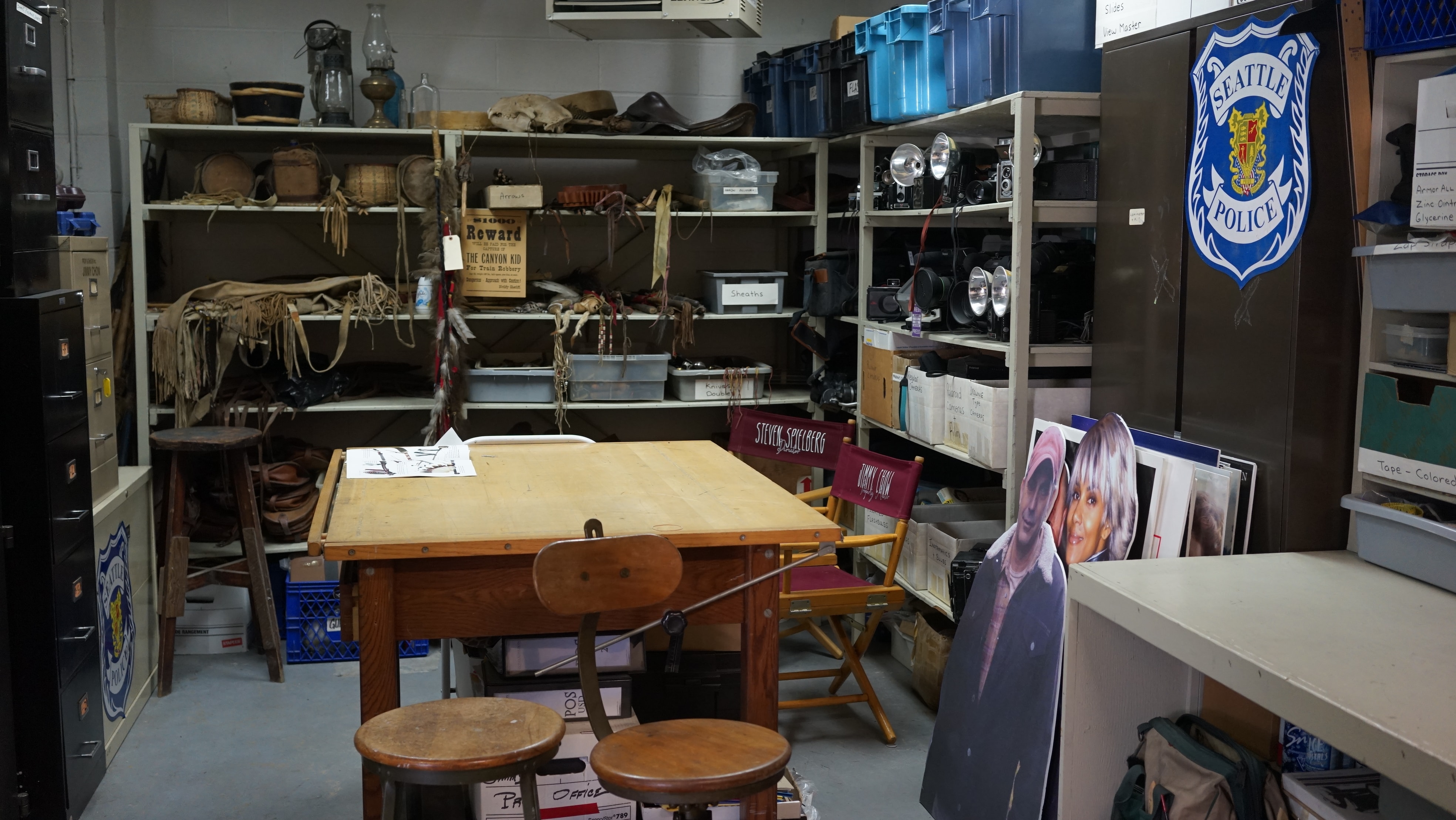
Jimmy Chow's work space and prop supplies
https://search.heritageburnaby.ca/link/museumdescription19156
- Repository
- Burnaby Village Museum
- Date
- 2022
- Collection/Fonds
- Hipman "Jimmy" Chow and Donna Polos fonds
- Description Level
- Item
- Physical Description
- 1 photograph (jpg)
- Scope and Content
- Photograph of the interior of property master Jimmy Chow's warehouse studio space located on Grant Street in Burnaby. View of workspace with table, shelving and cabinets with boxes of supplies and lanterns hanging from the ceiling.
- Repository
- Burnaby Village Museum
- Collection/Fonds
- Hipman "Jimmy" Chow and Donna Polos fonds
- Description Level
- Item
- Physical Description
- 1 photograph (jpg)
- Scope and Content
- Photograph of the interior of property master Jimmy Chow's warehouse studio space located on Grant Street in Burnaby. View of workspace with table, shelving and cabinets with boxes of supplies and lanterns hanging from the ceiling.
- Subjects
- Industries - Film
- Accession Code
- BV022.21.3
- Access Restriction
- No restrictions
- Reproduction Restriction
- No known restrictions
- Date
- 2022
- Media Type
- Photograph
- Photographer
- Fong, Denise
- Notes
- Title based on contents of photograph
- Hipman "Jimmy" Chow also used the name "James H. Chow" as a propety master in the film industry and was often credited by this name
Images
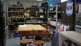
Jimmy Chow's work space and prop supplies
https://search.heritageburnaby.ca/link/museumdescription19157
- Repository
- Burnaby Village Museum
- Date
- 2022
- Collection/Fonds
- Hipman "Jimmy" Chow and Donna Polos fonds
- Description Level
- Item
- Physical Description
- 1 photograph (jpg)
- Scope and Content
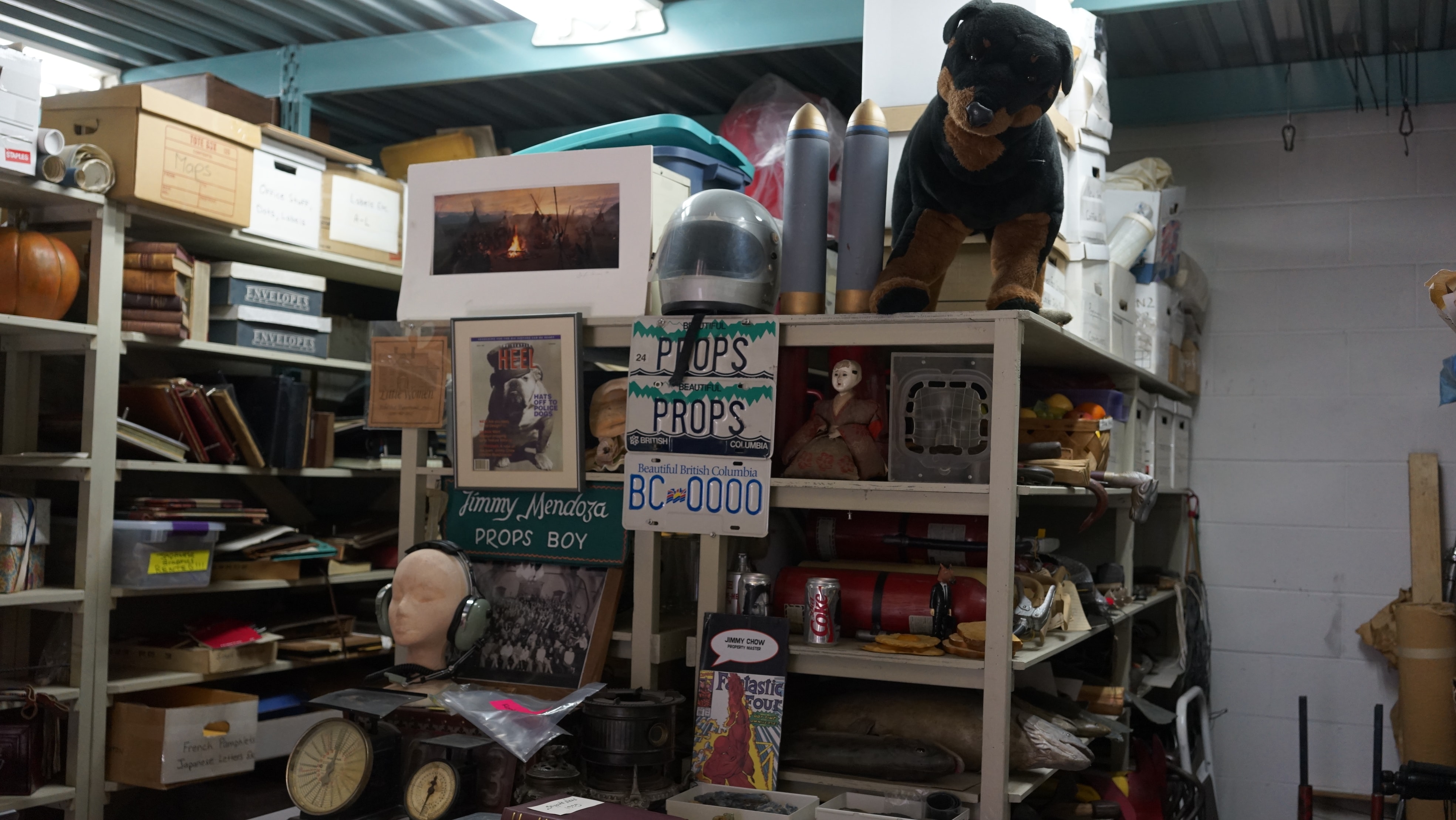
- Photograph of the interior of property master Jimmy Chow's warehouse studio space located on Grant Street in Burnaby. View of interior of workspace with table in centre surrounded by shelving and cabinets holding supplies and props that Jimmy utilized as a Property Master working in the film indust…
- Repository
- Burnaby Village Museum
- Collection/Fonds
- Hipman "Jimmy" Chow and Donna Polos fonds
- Description Level
- Item
- Physical Description
- 1 photograph (jpg)
- Scope and Content
- Photograph of the interior of property master Jimmy Chow's warehouse studio space located on Grant Street in Burnaby. View of interior of workspace with table in centre surrounded by shelving and cabinets holding supplies and props that Jimmy utilized as a Property Master working in the film industry.
- Subjects
- Industries - Film
- Accession Code
- BV022.21.4
- Access Restriction
- No restrictions
- Reproduction Restriction
- No known restrictions
- Date
- 2022
- Media Type
- Photograph
- Photographer
- Fong, Denise
- Notes
- Title based on contents of photograph
- Hipman "Jimmy" Chow also used the name "James H. Chow" as a propety master in the film industry and was often credited by this name
Images
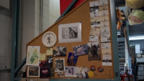
Bulletin board inside Jimmy Chow's office
https://search.heritageburnaby.ca/link/museumdescription19158
- Repository
- Burnaby Village Museum
- Date
- 2022
- Collection/Fonds
- Hipman "Jimmy" Chow and Donna Polos fonds
- Description Level
- Item
- Physical Description
- 1 photograph (jpg)
- Scope and Content
- Photograph of the interior of property master Jimmy Chow's warehouse studio space located on Grant Street in Burnaby. View of interior of workspace with cards and photographs pinned to a bulletin board. There is a large black and white photograph of Brad Pitt in costume on the set for the film "Sev…
- Repository
- Burnaby Village Museum
- Collection/Fonds
- Hipman "Jimmy" Chow and Donna Polos fonds
- Description Level
- Item
- Physical Description
- 1 photograph (jpg)
- Scope and Content
- Photograph of the interior of property master Jimmy Chow's warehouse studio space located on Grant Street in Burnaby. View of interior of workspace with cards and photographs pinned to a bulletin board. There is a large black and white photograph of Brad Pitt in costume on the set for the film "Seven Years in Tibet" pinned to the board.
- Subjects
- Industries - Film
- Accession Code
- BV022.21.5
- Access Restriction
- No restrictions
- Reproduction Restriction
- No known restrictions
- Date
- 2022
- Media Type
- Photograph
- Photographer
- Fong, Denise
- Notes
- Title based on contents of photograph
- Hipman "Jimmy" Chow also used the name "James H. Chow" as a propety master in the film industry and was often credited by this name
Images

Jimmy Chow's props and supplies
https://search.heritageburnaby.ca/link/museumdescription19159
- Repository
- Burnaby Village Museum
- Date
- 2022
- Collection/Fonds
- Hipman "Jimmy" Chow and Donna Polos fonds
- Description Level
- Item
- Physical Description
- 1 photograph (jpg)
- Scope and Content
- Photograph of the interior of property master Jimmy Chow's warehouse studio space located on Grant Street in Burnaby. View of interior of workspace with shelving holding supplies and props that Jimmy utilized as a Property Master working in the film industry.
- Repository
- Burnaby Village Museum
- Collection/Fonds
- Hipman "Jimmy" Chow and Donna Polos fonds
- Description Level
- Item
- Physical Description
- 1 photograph (jpg)
- Scope and Content
- Photograph of the interior of property master Jimmy Chow's warehouse studio space located on Grant Street in Burnaby. View of interior of workspace with shelving holding supplies and props that Jimmy utilized as a Property Master working in the film industry.
- Subjects
- Industries - Film
- Accession Code
- BV022.21.6
- Access Restriction
- No restrictions
- Reproduction Restriction
- No known restrictions
- Date
- 2022
- Media Type
- Photograph
- Photographer
- Fong, Denise
- Notes
- Title based on contents of photograph
- Hipman "Jimmy" Chow also used the name "James H. Chow" as a propety master in the film industry and was often credited by this name
Images
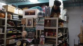
Jimmy Chow's props inside warehouse
https://search.heritageburnaby.ca/link/museumdescription19161
- Repository
- Burnaby Village Museum
- Date
- 2022
- Collection/Fonds
- Hipman "Jimmy" Chow and Donna Polos fonds
- Description Level
- Item
- Physical Description
- 1 photograph (jpg)
- Scope and Content
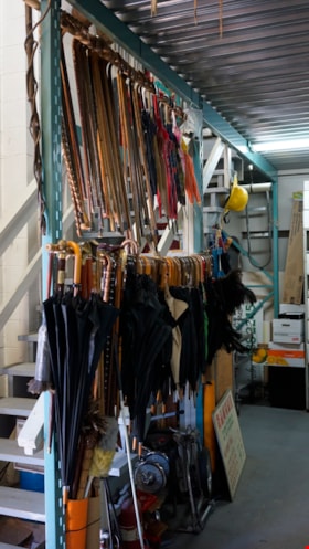
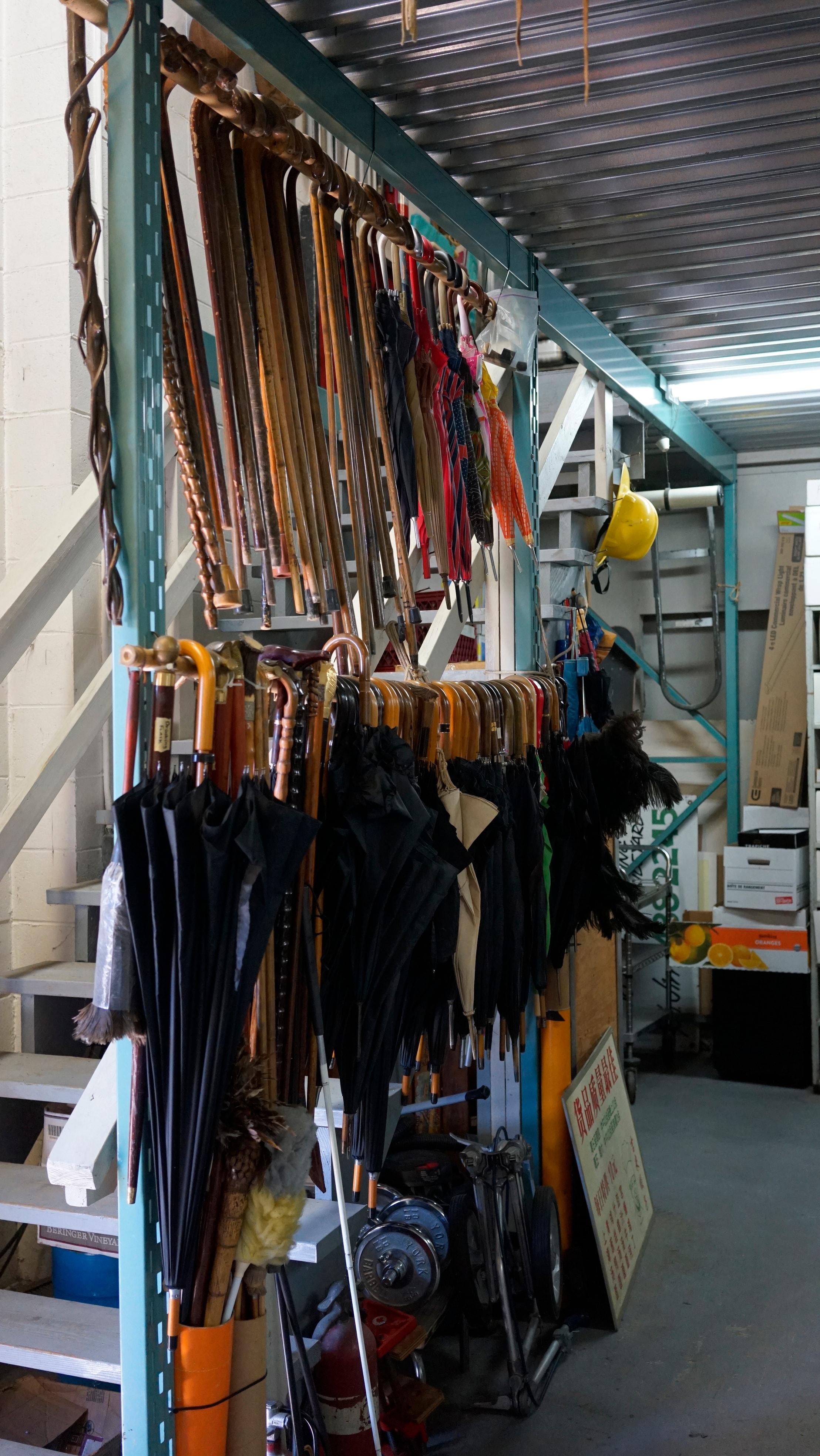
- Photograph of the interior of property master Jimmy Chow's warehouse studio space located on Grant Street in Burnaby. View of interior of space with umbrellas and canes hanging from racks next to a staircase.
- Repository
- Burnaby Village Museum
- Collection/Fonds
- Hipman "Jimmy" Chow and Donna Polos fonds
- Description Level
- Item
- Physical Description
- 1 photograph (jpg)
- Scope and Content
- Photograph of the interior of property master Jimmy Chow's warehouse studio space located on Grant Street in Burnaby. View of interior of space with umbrellas and canes hanging from racks next to a staircase.
- Subjects
- Industries - Film
- Accession Code
- BV022.21.7
- Access Restriction
- No restrictions
- Reproduction Restriction
- No known restrictions
- Date
- 2022
- Media Type
- Photograph
- Photographer
- Fong, Denise
- Notes
- Title based on contents of photograph
- Hipman "Jimmy" Chow also used the name "James H. Chow" as a propety master in the film industry and was often credited by this name
Images
Jimmy Chow's props inside warehouse
https://search.heritageburnaby.ca/link/museumdescription19162
- Repository
- Burnaby Village Museum
- Date
- 2022
- Collection/Fonds
- Hipman "Jimmy" Chow and Donna Polos fonds
- Description Level
- Item
- Physical Description
- 1 photograph (jpg)
- Scope and Content
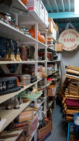
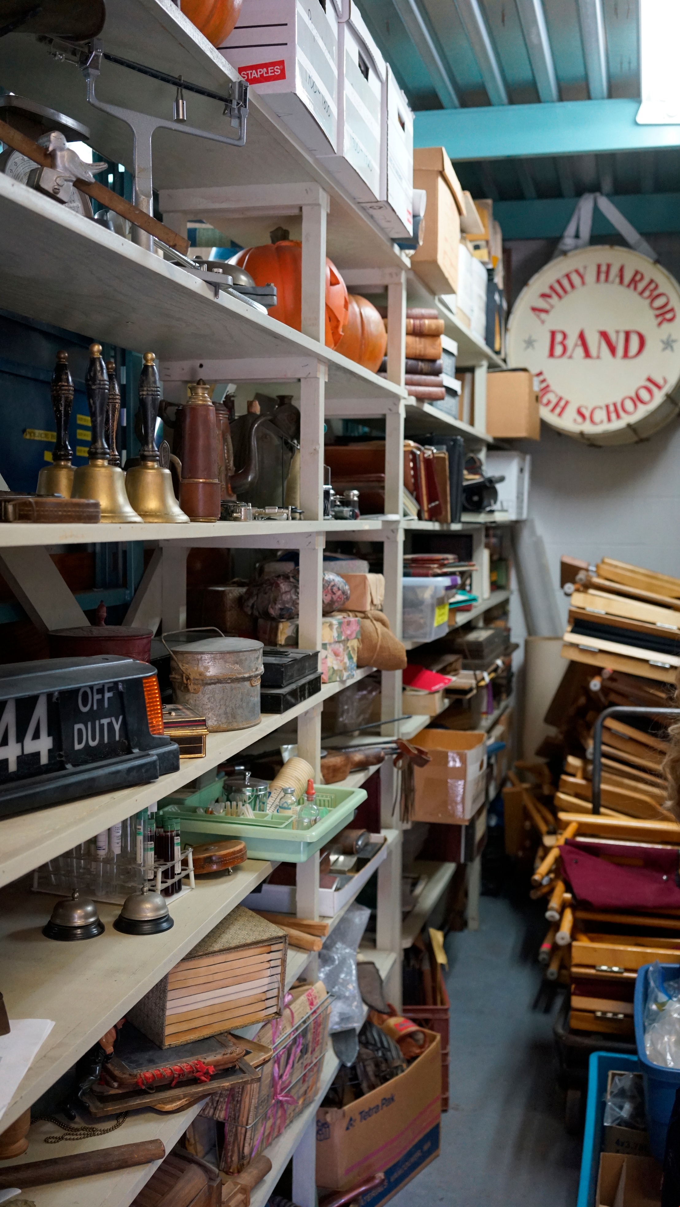
- Photograph of the interior of property master Jimmy Chow's warehouse studio space located on Grant Street in Burnaby located on Grant Street in Burnaby. View of interior of space with a variety of props arranged on shelving and director's chairs stacked together next to shelves. A bass drum with i…
- Repository
- Burnaby Village Museum
- Collection/Fonds
- Hipman "Jimmy" Chow and Donna Polos fonds
- Description Level
- Item
- Physical Description
- 1 photograph (jpg)
- Scope and Content
- Photograph of the interior of property master Jimmy Chow's warehouse studio space located on Grant Street in Burnaby located on Grant Street in Burnaby. View of interior of space with a variety of props arranged on shelving and director's chairs stacked together next to shelves. A bass drum with insignia "AMITY HARBOR / BAND / HIGH SCHOOL" is hanging on the back wall.
- Subjects
- Industries - Film
- Accession Code
- BV022.21.8
- Access Restriction
- No restrictions
- Reproduction Restriction
- No known restrictions
- Date
- 2022
- Media Type
- Photograph
- Photographer
- Fong, Denise
- Notes
- Title based on contents of photograph
- Hipman "Jimmy" Chow also used the name "James H. Chow" as a propety master in the film industry and was often credited by this name
Images

Jimmy Chow inside his warehouse
https://search.heritageburnaby.ca/link/museumdescription19163
- Repository
- Burnaby Village Museum
- Date
- 2022
- Collection/Fonds
- Hipman "Jimmy" Chow and Donna Polos fonds
- Description Level
- Item
- Physical Description
- 1 photograph (jpg)
- Scope and Content
- Photograph of property master Jimmy Chow standing inside his warehouse and studio space located on Grant Street in Burnaby. Interior of space with shelving and upstairs storage space filled with a variety props and supplies.
- Repository
- Burnaby Village Museum
- Collection/Fonds
- Hipman "Jimmy" Chow and Donna Polos fonds
- Description Level
- Item
- Physical Description
- 1 photograph (jpg)
- Scope and Content
- Photograph of property master Jimmy Chow standing inside his warehouse and studio space located on Grant Street in Burnaby. Interior of space with shelving and upstairs storage space filled with a variety props and supplies.
- Subjects
- Industries - Film
- Accession Code
- BV022.21.9
- Access Restriction
- No restrictions
- Reproduction Restriction
- No known restrictions
- Date
- 2022
- Media Type
- Photograph
- Photographer
- Fong, Denise
- Notes
- Title based on contents of photograph
- Hipman "Jimmy" Chow also used the name "James H. Chow" as a propety master in the film industry and was often credited by this name
Images
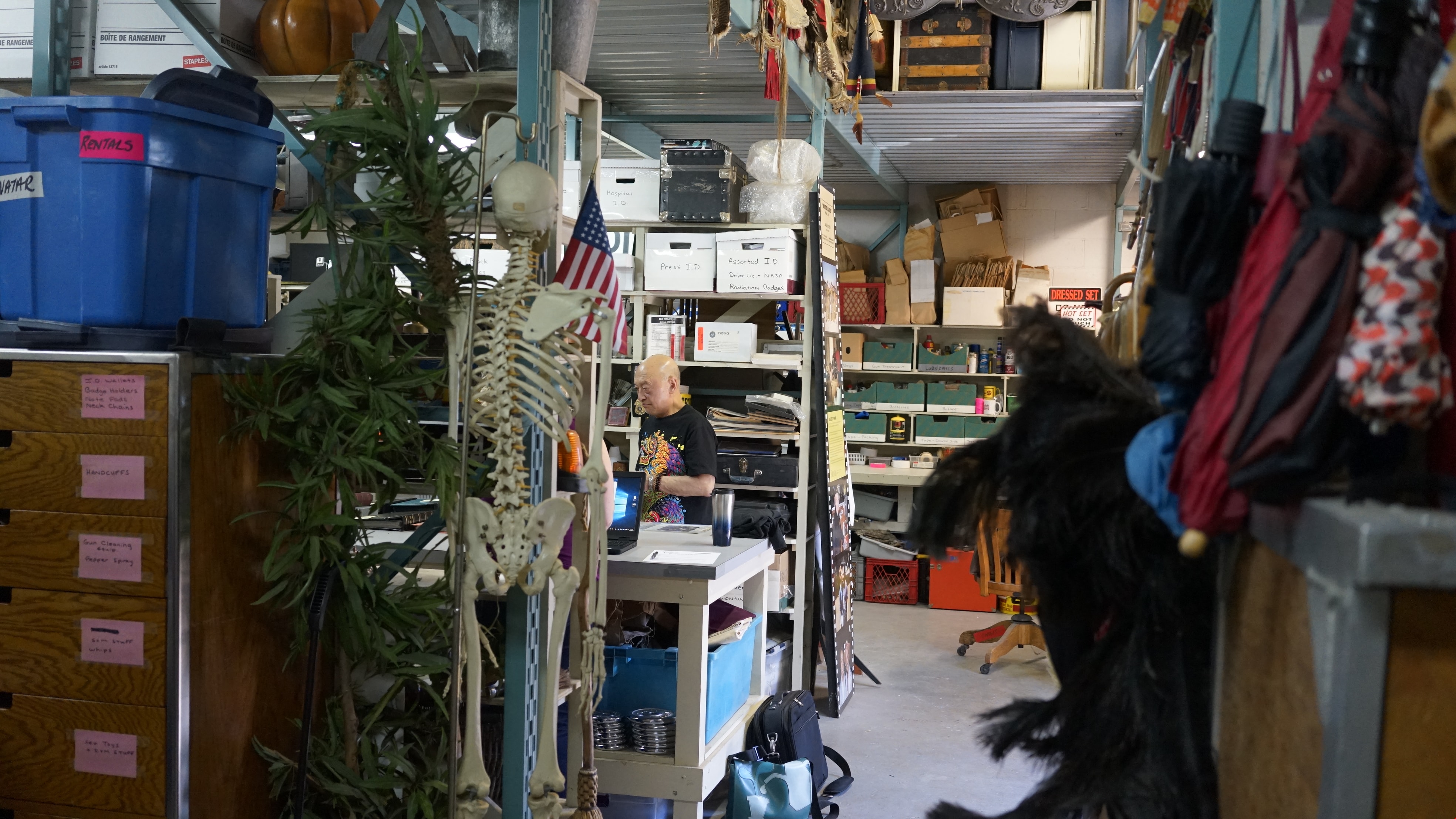
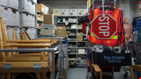
Jimmy Chow's props inside warehouse
https://search.heritageburnaby.ca/link/museumdescription19164
- Repository
- Burnaby Village Museum
- Date
- 2022
- Collection/Fonds
- Hipman "Jimmy" Chow and Donna Polos fonds
- Description Level
- Item
- Physical Description
- 1 photograph (jpg)
- Scope and Content
- Photograph of props and supplies arranged on racks and shelving inside property master Jimmy Chow's warehouse and studio space located on Grant Street in Burnaby.
- Repository
- Burnaby Village Museum
- Collection/Fonds
- Hipman "Jimmy" Chow and Donna Polos fonds
- Description Level
- Item
- Physical Description
- 1 photograph (jpg)
- Scope and Content
- Photograph of props and supplies arranged on racks and shelving inside property master Jimmy Chow's warehouse and studio space located on Grant Street in Burnaby.
- Subjects
- Industries - Film
- Accession Code
- BV022.21.10
- Access Restriction
- No restrictions
- Reproduction Restriction
- No known restrictions
- Date
- 2022
- Media Type
- Photograph
- Photographer
- Fong, Denise
- Notes
- Title based on contents of photograph
- Hipman "Jimmy" Chow also used the name "James H. Chow" as a propety master in the film industry and was often credited by this name
Images
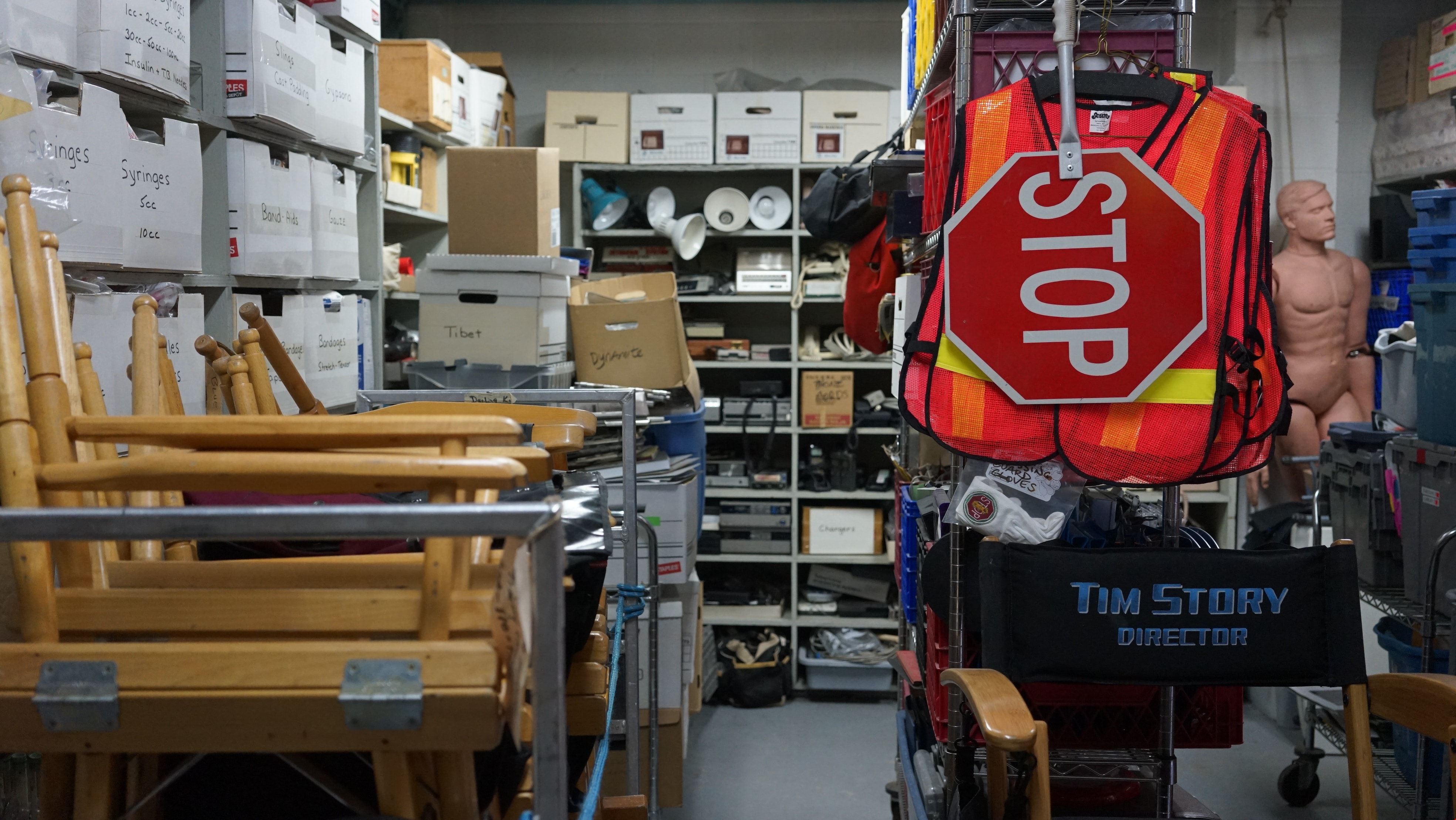

Jimmy Chow's props inside warehouse
https://search.heritageburnaby.ca/link/museumdescription19165
- Repository
- Burnaby Village Museum
- Date
- 2022
- Collection/Fonds
- Hipman "Jimmy" Chow and Donna Polos fonds
- Description Level
- Item
- Physical Description
- 1 photograph (jpg)
- Scope and Content
- Photograph of a variety of props arranged on shelving and in metal cabinets inside property master Jimmy Chow's warehouse and studio space located on Grant Street in Burnaby. An arrangment of police officers' belts are hanging on the side of a metal cabinet with baskets stacked on top, back shelvin…
- Repository
- Burnaby Village Museum
- Collection/Fonds
- Hipman "Jimmy" Chow and Donna Polos fonds
- Description Level
- Item
- Physical Description
- 1 photograph (jpg)
- Scope and Content
- Photograph of a variety of props arranged on shelving and in metal cabinets inside property master Jimmy Chow's warehouse and studio space located on Grant Street in Burnaby. An arrangment of police officers' belts are hanging on the side of a metal cabinet with baskets stacked on top, back shelving holds blankets and baskets. Metal cabinets have white paper signs adhered to the outside identifying contents within.
- Subjects
- Industries - Film
- Accession Code
- BV022.21.11
- Access Restriction
- No restrictions
- Reproduction Restriction
- No known restrictions
- Date
- 2022
- Media Type
- Photograph
- Photographer
- Fong, Denise
- Notes
- Title based on contents of photograph
- Hipman "Jimmy" Chow also used the name "James H. Chow" as a propety master in the film industry and was often credited by this name
Images
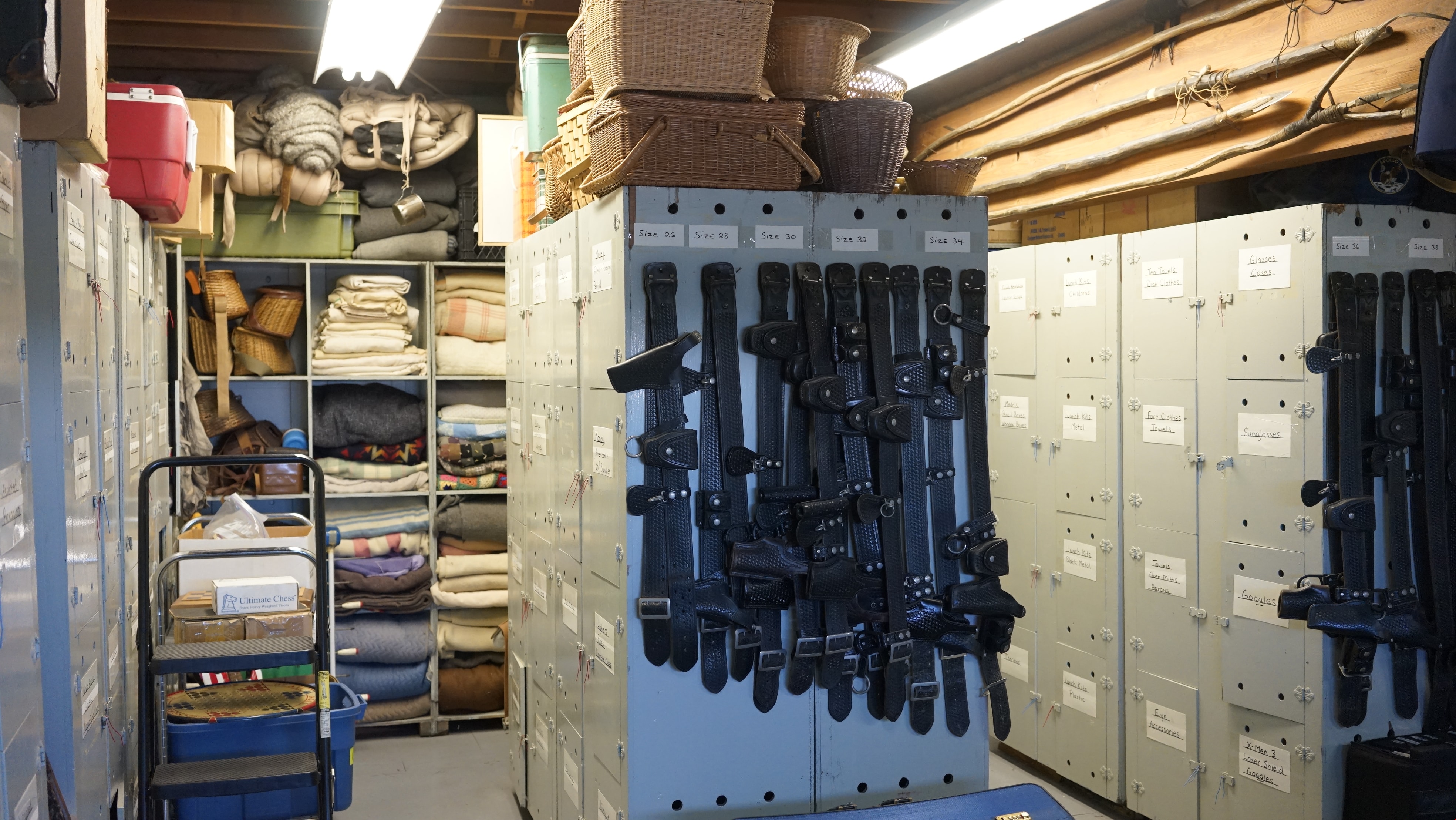
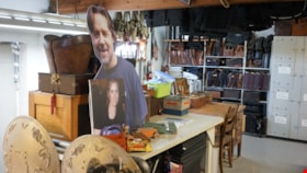
Jimmy Chow's props inside warehouse
https://search.heritageburnaby.ca/link/museumdescription19166
- Repository
- Burnaby Village Museum
- Date
- 2022
- Collection/Fonds
- Hipman "Jimmy" Chow and Donna Polos fonds
- Description Level
- Item
- Physical Description
- 1 photograph (jpg)
- Scope and Content
- Photograph of a variety of props arranged on shelving and tables inside property master Jimmy Chow's warehouse and studio space. Table holds a variety of boxes and containers as well as a large celebrity cutout of actor Russell Crowe, and mounted photograph of actor Amy Adams (Amy Adams and Rusell …
- Repository
- Burnaby Village Museum
- Collection/Fonds
- Hipman "Jimmy" Chow and Donna Polos fonds
- Description Level
- Item
- Physical Description
- 1 photograph (jpg)
- Scope and Content
- Photograph of a variety of props arranged on shelving and tables inside property master Jimmy Chow's warehouse and studio space. Table holds a variety of boxes and containers as well as a large celebrity cutout of actor Russell Crowe, and mounted photograph of actor Amy Adams (Amy Adams and Rusell Crowe were actors in "Man of Steel" which was filmed in Vancouver. Jimmy was the property master for this movie). Shelving at back of space hodls a variety of leather briefcases and suitcases.
- Subjects
- Industries - Film
- Accession Code
- BV022.21.12
- Access Restriction
- No restrictions
- Reproduction Restriction
- No known restrictions
- Date
- 2022
- Media Type
- Photograph
- Photographer
- Fong, Denise
- Notes
- Title based on contents of photograph
- Hipman "Jimmy" Chow also used the name "James H. Chow" as a propety master in the film industry and was often credited by this name
Images
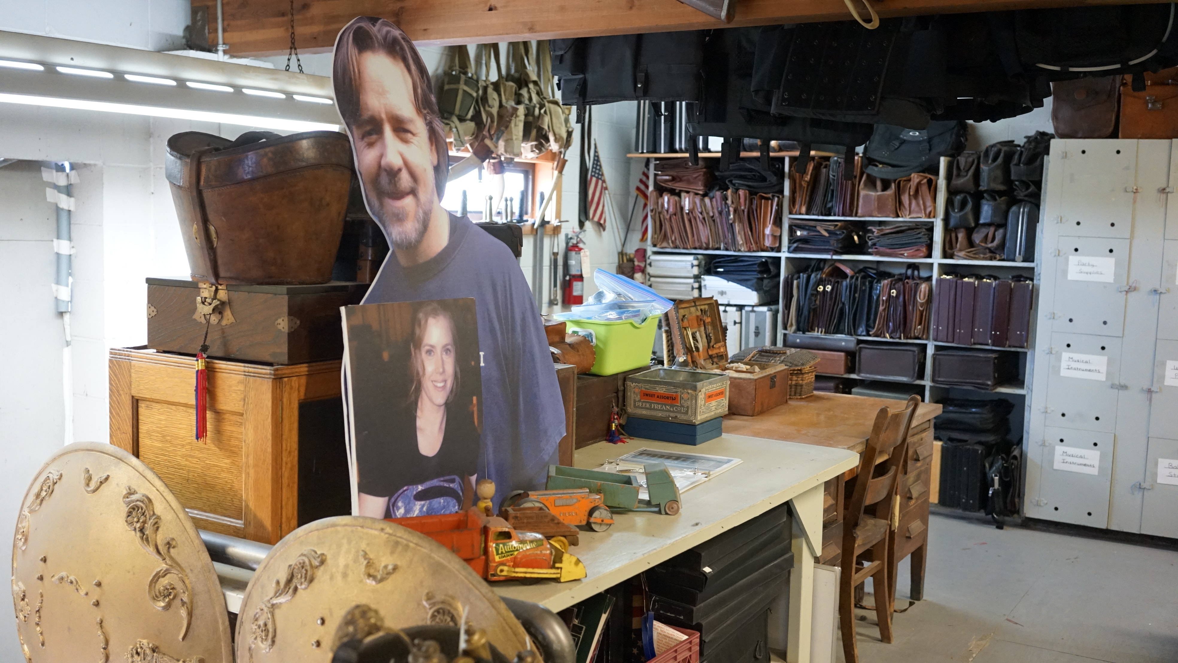
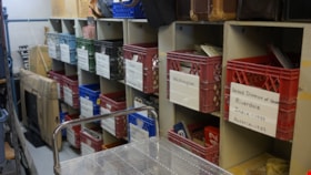
Jimmy Chow's props inside warehouse
https://search.heritageburnaby.ca/link/museumdescription19167
- Repository
- Burnaby Village Museum
- Date
- 2022
- Collection/Fonds
- Hipman "Jimmy" Chow and Donna Polos fonds
- Description Level
- Item
- Physical Description
- 1 photograph (jpg)
- Scope and Content
- Photograph of crates holding a variety of license plates arranged on shelving inside property master Jimmy Chow's warehouse and studio space located on Grant Street in Burnaby. White labels on outside of crates identifies the region and time period of the license plates within.
- Repository
- Burnaby Village Museum
- Collection/Fonds
- Hipman "Jimmy" Chow and Donna Polos fonds
- Description Level
- Item
- Physical Description
- 1 photograph (jpg)
- Scope and Content
- Photograph of crates holding a variety of license plates arranged on shelving inside property master Jimmy Chow's warehouse and studio space located on Grant Street in Burnaby. White labels on outside of crates identifies the region and time period of the license plates within.
- Subjects
- Industries - Film
- Accession Code
- BV022.21.13
- Access Restriction
- No restrictions
- Reproduction Restriction
- No known restrictions
- Date
- 2022
- Media Type
- Photograph
- Photographer
- Fong, Denise
- Notes
- Title based on contents of photograph
- Hipman "Jimmy" Chow also used the name "James H. Chow" as a propety master in the film industry and was often credited by this name
Images

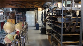
Jimmy Chow's props inside warehouse
https://search.heritageburnaby.ca/link/museumdescription19168
- Repository
- Burnaby Village Museum
- Date
- 2022
- Collection/Fonds
- Hipman "Jimmy" Chow and Donna Polos fonds
- Description Level
- Item
- Physical Description
- 1 photograph (jpg)
- Scope and Content
- Photograph of a variety of props arranged on shelving, walls and racks inside property master Jimmy Chow's warehouse and studio space located on Grant Street in Burnaby. This sections holds a variety of weapons including firearms, swords and shields.
- Repository
- Burnaby Village Museum
- Collection/Fonds
- Hipman "Jimmy" Chow and Donna Polos fonds
- Description Level
- Item
- Physical Description
- 1 photograph (jpg)
- Scope and Content
- Photograph of a variety of props arranged on shelving, walls and racks inside property master Jimmy Chow's warehouse and studio space located on Grant Street in Burnaby. This sections holds a variety of weapons including firearms, swords and shields.
- Subjects
- Industries - Film
- Accession Code
- BV022.21.14
- Access Restriction
- No restrictions
- Reproduction Restriction
- No known restrictions
- Date
- 2022
- Media Type
- Photograph
- Photographer
- Fong, Denise
- Notes
- Title based on contents of photograph
- Hipman "Jimmy" Chow also used the name "James H. Chow" as a propety master in the film industry and was often credited by this name
Images
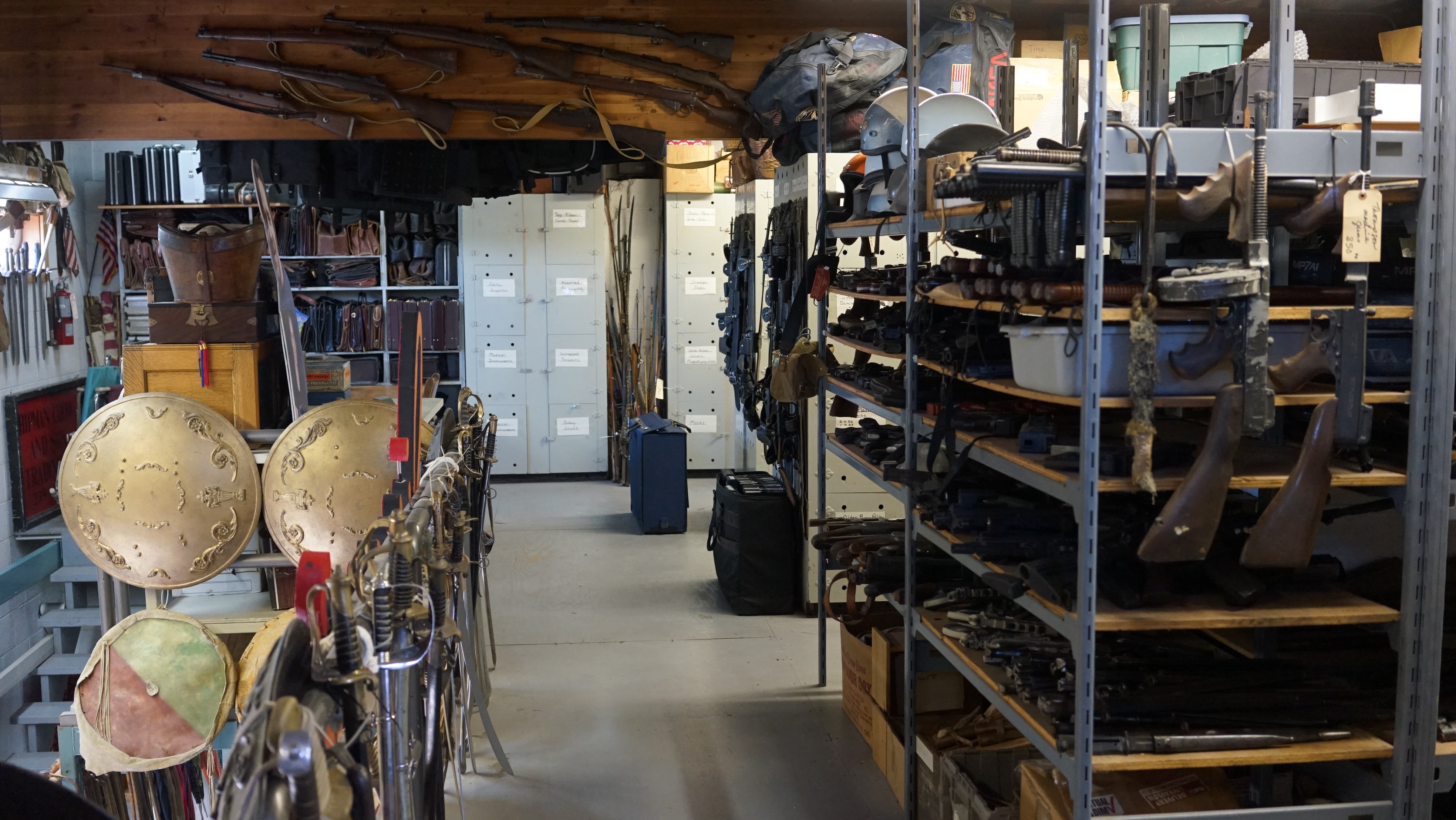
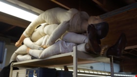
Jimmy Chow's props on shelving inside warehouse
https://search.heritageburnaby.ca/link/museumdescription19169
- Repository
- Burnaby Village Museum
- Date
- 2022
- Collection/Fonds
- Hipman "Jimmy" Chow and Donna Polos fonds
- Description Level
- Item
- Physical Description
- 1 photograph (jpg)
- Scope and Content
- Photograph of a cloth covered mannequins stacked together on shelving inside property master Jimmy Chow's warehouse and studio space located on Grant Street in Burnaby.
- Repository
- Burnaby Village Museum
- Collection/Fonds
- Hipman "Jimmy" Chow and Donna Polos fonds
- Description Level
- Item
- Physical Description
- 1 photograph (jpg)
- Scope and Content
- Photograph of a cloth covered mannequins stacked together on shelving inside property master Jimmy Chow's warehouse and studio space located on Grant Street in Burnaby.
- Subjects
- Industries - Film
- Accession Code
- BV022.21.15
- Access Restriction
- No restrictions
- Reproduction Restriction
- No known restrictions
- Date
- 2022
- Media Type
- Photograph
- Photographer
- Fong, Denise
- Notes
- Title based on contents of photograph
- Hipman "Jimmy" Chow also used the name "James H. Chow" as a propety master in the film industry and was often credited by this name
Images

Shields and "Jimmy's" sign inside Jimmy Chow's warehouse
https://search.heritageburnaby.ca/link/museumdescription19170
- Repository
- Burnaby Village Museum
- Date
- 2022
- Collection/Fonds
- Hipman "Jimmy" Chow and Donna Polos fonds
- Description Level
- Item
- Physical Description
- 1 photograph (jpg)
- Scope and Content
- Photograph of a large wooden sign that reads "Jimmy's" hanging from racking with an arrangment of shields inside property master Jimmy Chow's warehouse and studio space located on Grant Street in Burnaby.
- Repository
- Burnaby Village Museum
- Collection/Fonds
- Hipman "Jimmy" Chow and Donna Polos fonds
- Description Level
- Item
- Physical Description
- 1 photograph (jpg)
- Scope and Content
- Photograph of a large wooden sign that reads "Jimmy's" hanging from racking with an arrangment of shields inside property master Jimmy Chow's warehouse and studio space located on Grant Street in Burnaby.
- Subjects
- Industries - Film
- Accession Code
- BV022.21.16
- Access Restriction
- No restrictions
- Reproduction Restriction
- No known restrictions
- Date
- 2022
- Media Type
- Photograph
- Photographer
- Fong, Denise
- Notes
- Title based on contents of photograph
- Hipman "Jimmy" Chow also used the name "James H. Chow" as a propety master in the film industry and was often credited by this name
Images

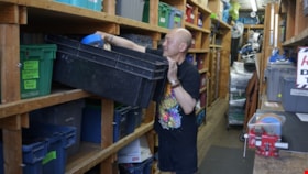
Jimmy Chow inside storage container
https://search.heritageburnaby.ca/link/museumdescription19171
- Repository
- Burnaby Village Museum
- Date
- 2022
- Collection/Fonds
- Hipman "Jimmy" Chow and Donna Polos fonds
- Description Level
- Item
- Physical Description
- 1 photograph (jpg)
- Scope and Content
- Photograph of property master Jimmy Chow sorting through a bin inside an overflow storage shiipping container near his warehouse and studio space located on Grant Street in Burnaby. Shelving inside container holds props and supplies that Jimmy used while working in the film industry.
- Repository
- Burnaby Village Museum
- Collection/Fonds
- Hipman "Jimmy" Chow and Donna Polos fonds
- Description Level
- Item
- Physical Description
- 1 photograph (jpg)
- Scope and Content
- Photograph of property master Jimmy Chow sorting through a bin inside an overflow storage shiipping container near his warehouse and studio space located on Grant Street in Burnaby. Shelving inside container holds props and supplies that Jimmy used while working in the film industry.
- Names
- Chow, Hipman "Jimmy"
- Accession Code
- BV022.21.17
- Access Restriction
- No restrictions
- Reproduction Restriction
- No known restrictions
- Date
- 2022
- Media Type
- Photograph
- Photographer
- Fong, Denise
- Notes
- Title based on contents of photograph
- Hipman "Jimmy" Chow also used the name "James H. Chow" as a propety master in the film industry and was often credited by this name
Images

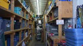
Interior of Jimmy Chow's storage container
https://search.heritageburnaby.ca/link/museumdescription19172
- Repository
- Burnaby Village Museum
- Date
- 2022
- Collection/Fonds
- Hipman "Jimmy" Chow and Donna Polos fonds
- Description Level
- Item
- Physical Description
- 1 photograph (jpg)
- Scope and Content
- Photograph of the interior an overflow storage shipping container located near property master Jimmy Chow's warehouse and studio space located on Grant Street in Burnaby. Shelving inside container holds props and supplies that Jimmy used while working in the film industry.
- Repository
- Burnaby Village Museum
- Collection/Fonds
- Hipman "Jimmy" Chow and Donna Polos fonds
- Description Level
- Item
- Physical Description
- 1 photograph (jpg)
- Scope and Content
- Photograph of the interior an overflow storage shipping container located near property master Jimmy Chow's warehouse and studio space located on Grant Street in Burnaby. Shelving inside container holds props and supplies that Jimmy used while working in the film industry.
- Subjects
- Industries - Film
- Accession Code
- BV022.21.18
- Access Restriction
- No restrictions
- Reproduction Restriction
- No known restrictions
- Date
- 2022
- Media Type
- Photograph
- Photographer
- Fong, Denise
- Notes
- Title based on contents of photograph
- Hipman "Jimmy" Chow also used the name "James H. Chow" as a propety master in the film industry and was often credited by this name
Images