Narrow Results By
Decade
- 2020s
- 2010s 4301
- 2000s 7770
- 1990s 10817
- 1980s 10036
- 1970s 14609
- 1960s 10659
- 1950s 9047
- 1940s 5581
- 1930s 5855
- 1920s 9630
- 1910s 7014
- 1900s 3170
- 1890s 1479
- 1880s 155
- 1870s 74
- 1860s 121
- 1850s 18
- 1840s 7
- 1830s 6
- 1820s 6
- 1810s 3
- 1800s 3
- 1790s 2
- 1780s 2
- 1770s 2
- 1760s 2
- 1750s 2
- 1740s 2
- 1730s 2
- 1720s 2
- 1710s 2
- 1700s 2
- 1690s 2
- 1680s 2
- 1670s 1
- 1660s 1
- 1650s 1
- 1640s 1
- 1630s 1
- 1620s 1
- 1610s 1
- 1600s 1
- 1590s 1
- 1580s 1
- 1570s 1
- 1560s 1
- 1550s 1
- 1540s 1
- 1530s 1
- 1520s 1
- 1510s 1
- 1500s 1
- 1490s 1
- 1480s 1
Subject
- Advertising Medium - Signs and Signboards 33
- Buildings - Civic - Hospitals 1
- Buildings - Civic - Libraries 1
- Buildings - Commercial 5
- Buildings - Commercial - Drugstores 1
- Buildings - Commercial - Grocery Stores 10
- Buildings - Commercial - Malls 2
- Buildings - Commercial - Offices 1
- Buildings - Commercial - Restaurants 4
- Buildings - Commercial - Service Stations 1
- Buildings - Commercial - Stores 1
- Buildings - Heritage 1

Oh! Zhhu Sam
https://search.heritageburnaby.ca/link/archivedescription98681
- Repository
- City of Burnaby Archives
- Date
- 2022
- Collection/Fonds
- Disappearing Burnaby collection
- Description Level
- Item
- Physical Description
- 1 photograph (jpeg) : col.
- Scope and Content
- Photograph of the 7500 block of Edmonds Street at dusk. The photograph is taken from across Edmonds Street and depicts two commercial buildings: Oh! Zzhu Sam Korean Restaurant and the European Butcher Boy Delicatessen & Grocery. Oh! Zzhu Sam, located at 7506 Edmonds Street, was constructed in 1976.…
- Repository
- City of Burnaby Archives
- Date
- 2022
- Collection/Fonds
- Disappearing Burnaby collection
- Physical Description
- 1 photograph (jpeg) : col.
- Description Level
- Item
- Record No.
- 634-028
- Access Restriction
- No restrictions
- Reproduction Restriction
- No restrictions
- Accession Number
- 2022-14
- Scope and Content
- Photograph of the 7500 block of Edmonds Street at dusk. The photograph is taken from across Edmonds Street and depicts two commercial buildings: Oh! Zzhu Sam Korean Restaurant and the European Butcher Boy Delicatessen & Grocery. Oh! Zzhu Sam, located at 7506 Edmonds Street, was constructed in 1976. Residential houses border the restaurant and grocery store, and a bus shelter, municipal garbage can, and the restaurant's illuminated neon sign stand in front of the buildings.
- Subjects
- Buildings - Commercial
- Buildings - Commercial - Grocery Stores
- Buildings - Commercial - Restaurants
- Media Type
- Photograph
- Photographer
- Cheung, Nakita
- Notes
- Title taken from the associated blog post
- Associated blog post: https://disappearingburnaby.wordpress.com/2022/07/29/oh-zzhu-sam/
- Geographic Access
- Edmonds Street
- Street Address
- 7506 Edmonds Street
- Historic Neighbourhood
- Edmonds (Historic Neighbourhood)
- Planning Study Area
- Edmonds Area
Images


One person per household
https://search.heritageburnaby.ca/link/archivedescription95109
- Repository
- City of Burnaby Archives
- Date
- April 27, 2020
- Collection/Fonds
- Burnaby Photographic Society fonds
- Description Level
- Item
- Physical Description
- 1 photograph (tiff)
- Scope and Content
- Photograph of the entrance at Save-On-Foods grocery store. One of the two doors at the entrance is blocked by a freestanding sign that reads: "To prevent the spread of COVID-19 Limit 1 person per household". Next to the sign is a shopping cart with signage attached to it informing shoppers that r…
- Repository
- City of Burnaby Archives
- Date
- April 27, 2020
- Collection/Fonds
- Burnaby Photographic Society fonds
- Physical Description
- 1 photograph (tiff)
- Description Level
- Item
- Record No.
- 623-027
- Access Restriction
- No restrictions
- Reproduction Restriction
- No restrictions
- Accession Number
- 2020-10
- Scope and Content
- Photograph of the entrance at Save-On-Foods grocery store. One of the two doors at the entrance is blocked by a freestanding sign that reads: "To prevent the spread of COVID-19 Limit 1 person per household". Next to the sign is a shopping cart with signage attached to it informing shoppers that reusable and cloth bags are prohibited in the store.
- Media Type
- Photograph
- Photographer
- Snowdon, Nick
- Notes
- Transcribed title
- Photographer's caption: "Early on in the pandemic, stores limit number of people from one household. This does not last very long."
- Geographic Access
- Kingsway
- Street Address
- 4429 Kingsway
- Historic Neighbourhood
- Central Park (Historic Neighbourhood)
- Planning Study Area
- Garden Village Area
Images


One way only
https://search.heritageburnaby.ca/link/archivedescription95108
- Repository
- City of Burnaby Archives
- Date
- April 27, 2020
- Collection/Fonds
- Burnaby Photographic Society fonds
- Description Level
- Item
- Physical Description
- 1 photograph (tiff)
- Scope and Content
- Photograph of the baking aisle in Save-On-Foods grocery store. A large red decal on the floor reads "STOP please enter aisle from other end".
- Repository
- City of Burnaby Archives
- Date
- April 27, 2020
- Collection/Fonds
- Burnaby Photographic Society fonds
- Physical Description
- 1 photograph (tiff)
- Description Level
- Item
- Record No.
- 623-026
- Access Restriction
- No restrictions
- Reproduction Restriction
- No restrictions
- Accession Number
- 2020-10
- Scope and Content
- Photograph of the baking aisle in Save-On-Foods grocery store. A large red decal on the floor reads "STOP please enter aisle from other end".
- Media Type
- Photograph
- Photographer
- Snowdon, Nick
- Notes
- Transcribed title
- Photographer's caption: "One way system imposed in store. Not everyone obeys"
- Geographic Access
- Kingsway
- Street Address
- 4429 Kingsway
- Historic Neighbourhood
- Central Park (Historic Neighbourhood)
- Planning Study Area
- Garden Village Area
Images


On On Wonton House
https://search.heritageburnaby.ca/link/archivedescription98670
- Repository
- City of Burnaby Archives
- Date
- 2022
- Collection/Fonds
- Disappearing Burnaby collection
- Description Level
- Item
- Physical Description
- 1 photograph (jpeg) : col.
- Scope and Content
- Photograph of the exterior of the On On Wonton House restaurant, located at 5640 Kingsway. The photograph is taken from across Kingsway at night. The building, which was constructed in 1959, is lit up with lights and a bright sign, and several cars are parked in the lot in front of the restaurant.
- Repository
- City of Burnaby Archives
- Date
- 2022
- Collection/Fonds
- Disappearing Burnaby collection
- Physical Description
- 1 photograph (jpeg) : col.
- Description Level
- Item
- Record No.
- 634-017
- Access Restriction
- No restrictions
- Reproduction Restriction
- No restrictions
- Accession Number
- 2022-14
- Scope and Content
- Photograph of the exterior of the On On Wonton House restaurant, located at 5640 Kingsway. The photograph is taken from across Kingsway at night. The building, which was constructed in 1959, is lit up with lights and a bright sign, and several cars are parked in the lot in front of the restaurant.
- Media Type
- Photograph
- Photographer
- Cheung, Nakita
- Notes
- Title taken from the associated blog post
- Associated blog post: https://disappearingburnaby.wordpress.com/2022/06/06/on-on-wonton-house/
- Geographic Access
- Kingsway
- Street Address
- 5640 Kingsway
- Historic Neighbourhood
- Central Park (Historic Neighbourhood)
- Planning Study Area
- Windsor Area
Images


Out of Stock
https://search.heritageburnaby.ca/link/archivedescription95125
- Repository
- City of Burnaby Archives
- Date
- April 10, 2020
- Collection/Fonds
- Burnaby Photographic Society fonds
- Description Level
- Item
- Physical Description
- 1 photograph (tiff)
- Scope and Content
- Photograph of a sign in the window of a Pharmasave drugstore advertising the supplies it has available. The sign features "yes" and "no" columns with velcro patches to which checkmarks and crosses are stuck to to indicate which supplies are currently in stock. Supplies listed include: face masks,…
- Repository
- City of Burnaby Archives
- Date
- April 10, 2020
- Collection/Fonds
- Burnaby Photographic Society fonds
- Physical Description
- 1 photograph (tiff)
- Description Level
- Item
- Record No.
- 623-043
- Access Restriction
- No restrictions
- Reproduction Restriction
- Reproduce for fair dealing purposes only
- Accession Number
- 2020-10
- Scope and Content
- Photograph of a sign in the window of a Pharmasave drugstore advertising the supplies it has available. The sign features "yes" and "no" columns with velcro patches to which checkmarks and crosses are stuck to to indicate which supplies are currently in stock. Supplies listed include: face masks, hand sanitizer, hand soap, rubbing alcohol, thermometers, gloves, Lysol wipes, Tylenol, and toilet paper.
- Media Type
- Photograph
- Photographer
- Jerome, Ron
- Notes
- Transcribed title
- Geographic Access
- Hastings Street
- Street Address
- 4367 Hastings Street
- Historic Neighbourhood
- Vancouver Heights (Historic Neighbourhood)
- Planning Study Area
- Burnaby Heights Area
Images


Pandemic Litter
https://search.heritageburnaby.ca/link/archivedescription95131
- Repository
- City of Burnaby Archives
- Date
- April 30, 2020
- Collection/Fonds
- Burnaby Photographic Society fonds
- Description Level
- Item
- Physical Description
- 1 photograph (tiff)
- Scope and Content
- Photograph of two blue rubber gloves discarded on the ground of the Kensington Square Shopping Centre parking lot in North Burnaby.
- Repository
- City of Burnaby Archives
- Date
- April 30, 2020
- Collection/Fonds
- Burnaby Photographic Society fonds
- Physical Description
- 1 photograph (tiff)
- Description Level
- Item
- Record No.
- 623-049
- Access Restriction
- No restrictions
- Reproduction Restriction
- No restrictions
- Accession Number
- 2020-10
- Scope and Content
- Photograph of two blue rubber gloves discarded on the ground of the Kensington Square Shopping Centre parking lot in North Burnaby.
- Media Type
- Photograph
- Photographer
- Lapierre, Soleil
- Notes
- Transcribed title
- Geographic Access
- Hastings Street
- Street Address
- 6500 Hastings Street
- Historic Neighbourhood
- Lochdale (Historic Neighbourhood)
- Planning Study Area
- Lochdale Area
Images

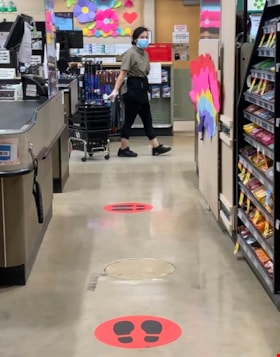
Physical distancing and PPE at Safeways
https://search.heritageburnaby.ca/link/archivedescription95105
- Repository
- City of Burnaby Archives
- Date
- May 30, 2020
- Collection/Fonds
- Burnaby Photographic Society fonds
- Description Level
- Item
- Physical Description
- 1 photograph (tiff)
- Scope and Content
- Photograph of a Safeway employee wheeling a stack of grocery baskets past a checkout lane. On the floor are large decals indicating where customers should stand to maintain safe distance from one another. The employee is wearing a face mask and white gloves.
- Repository
- City of Burnaby Archives
- Date
- May 30, 2020
- Collection/Fonds
- Burnaby Photographic Society fonds
- Physical Description
- 1 photograph (tiff)
- Description Level
- Item
- Record No.
- 623-023
- Access Restriction
- No restrictions
- Reproduction Restriction
- No restrictions
- Accession Number
- 2020-10
- Scope and Content
- Photograph of a Safeway employee wheeling a stack of grocery baskets past a checkout lane. On the floor are large decals indicating where customers should stand to maintain safe distance from one another. The employee is wearing a face mask and white gloves.
- Media Type
- Photograph
- Photographer
- King, Gloria
- Notes
- Transcribed title
- Geographic Access
- Hastings Street
- Street Address
- 4440 Hastings Street
- Historic Neighbourhood
- Vancouver Heights (Historic Neighbourhood)
- Planning Study Area
- Willingdon Heights Area
Images


Physical distancing sign
https://search.heritageburnaby.ca/link/archivedescription95106
- Repository
- City of Burnaby Archives
- Date
- 2020
- Collection/Fonds
- Burnaby Photographic Society fonds
- Description Level
- Item
- Physical Description
- 1 photograph (tiff)
- Scope and Content
- Photograph of the gardens outside the Shadbolt Centre of the Arts. In the foreground, attached to a tree is a sign encouraging social distancing; in the background is a jungle gym fenced off with orange mesh and caution tape to prohibit climbing.
- Repository
- City of Burnaby Archives
- Date
- 2020
- Collection/Fonds
- Burnaby Photographic Society fonds
- Physical Description
- 1 photograph (tiff)
- Description Level
- Item
- Record No.
- 623-024
- Access Restriction
- No restrictions
- Reproduction Restriction
- No restrictions
- Accession Number
- 2020-10
- Scope and Content
- Photograph of the gardens outside the Shadbolt Centre of the Arts. In the foreground, attached to a tree is a sign encouraging social distancing; in the background is a jungle gym fenced off with orange mesh and caution tape to prohibit climbing.
- Media Type
- Photograph
- Photographer
- King, Gloria
- Notes
- Transcribed title
- Geographic Access
- Deer Lake
- Street Address
- 6450 Deer Lake Avenue
- Historic Neighbourhood
- Burnaby Lake (Historic Neighbourhood)
- Planning Study Area
- Douglas-Gilpin Area
Images

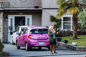
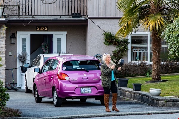
Pots & Pans
https://search.heritageburnaby.ca/link/archivedescription95124
- Repository
- City of Burnaby Archives
- Date
- April 8, 2020
- Collection/Fonds
- Burnaby Photographic Society fonds
- Description Level
- Item
- Physical Description
- 1 photograph (tiff)
- Scope and Content
- Photograph of Burnaby resident Michelle Leone banging a pot at the end of her driveway in support of healthcare workers.
- Repository
- City of Burnaby Archives
- Date
- April 8, 2020
- Collection/Fonds
- Burnaby Photographic Society fonds
- Physical Description
- 1 photograph (tiff)
- Description Level
- Item
- Record No.
- 623-042
- Access Restriction
- No restrictions
- Reproduction Restriction
- Reproduce for fair dealing purposes only
- Accession Number
- 2020-10
- Scope and Content
- Photograph of Burnaby resident Michelle Leone banging a pot at the end of her driveway in support of healthcare workers.
- Media Type
- Photograph
- Photographer
- Jerome, Ron
- Notes
- Transcribed title
- Geographic Access
- Heathdale Court
- Street Address
- 5386 Heathdale Court
- Planning Study Area
- Parkcrest-Aubrey Area
Images

Radiate Positive Vibes
https://search.heritageburnaby.ca/link/archivedescription95085
- Repository
- City of Burnaby Archives
- Date
- May 20, 2020
- Collection/Fonds
- Burnaby Photographic Society fonds
- Description Level
- Item
- Physical Description
- 1 photograph (tiff)
- Scope and Content
- Photograph of a multi-coloured chalk drawing in the lane connecting Laurel Street and Hyde Street, at Godwin Avenue. The drawing contains the message "Radiate Positive Vibes" surrounded by wavy concentric rings.
- Repository
- City of Burnaby Archives
- Date
- May 20, 2020
- Collection/Fonds
- Burnaby Photographic Society fonds
- Physical Description
- 1 photograph (tiff)
- Description Level
- Item
- Record No.
- 623-004
- Access Restriction
- No restrictions
- Reproduction Restriction
- No restrictions
- Accession Number
- 2020-10
- Scope and Content
- Photograph of a multi-coloured chalk drawing in the lane connecting Laurel Street and Hyde Street, at Godwin Avenue. The drawing contains the message "Radiate Positive Vibes" surrounded by wavy concentric rings.
- Subjects
- Buildings - Residential - Houses
- Media Type
- Photograph
- Photographer
- Gervan, Bonnie
- Notes
- Transcribed title
- Photographer's caption: "Chalk work by young resident reminding the neighbourhood to try and stay positive during the pandemic."
- Geographic Access
- Laurel Street
- Hyde Street
- Godwin Avenue
- Historic Neighbourhood
- Burnaby Lake (Historic Neighbourhood)
- Planning Study Area
- Douglas-Gilpin Area
Images


Radical sentiments
https://search.heritageburnaby.ca/link/archivedescription95098
- Repository
- City of Burnaby Archives
- Date
- April 29, 2020
- Collection/Fonds
- Burnaby Photographic Society fonds
- Description Level
- Item
- Physical Description
- 1 photograph (tiff)
- Scope and Content
- Photograph of a Socialist Alternative "Fight Coronavirus & Fight Capitalism" sign posted to a telephone poll near the BCIT campus.
- Repository
- City of Burnaby Archives
- Date
- April 29, 2020
- Collection/Fonds
- Burnaby Photographic Society fonds
- Physical Description
- 1 photograph (tiff)
- Description Level
- Item
- Record No.
- 623-017
- Access Restriction
- No restrictions
- Reproduction Restriction
- No restrictions
- Accession Number
- 2020-10
- Scope and Content
- Photograph of a Socialist Alternative "Fight Coronavirus & Fight Capitalism" sign posted to a telephone poll near the BCIT campus.
- Media Type
- Photograph
- Photographer
- Damer, Eric
- Notes
- Transcribed title
- Geographic Access
- Willingdon Avenue
- Sanderson Way
- Planning Study Area
- Cascade-Schou Area
Images


Reconstructed Central Park Band Stand
https://search.heritageburnaby.ca/link/archivedescription95123
- Repository
- City of Burnaby Archives
- Date
- May 28, 2020
- Collection/Fonds
- Burnaby Photographic Society fonds
- Description Level
- Item
- Physical Description
- 1 photograph (tiff)
- Scope and Content
- Photograph of the band stand in Central Park. The band stand stairs are blocked off with orange netting and a City of Burnaby facility closure sign.
- Repository
- City of Burnaby Archives
- Date
- May 28, 2020
- Collection/Fonds
- Burnaby Photographic Society fonds
- Physical Description
- 1 photograph (tiff)
- Description Level
- Item
- Record No.
- 623-041
- Access Restriction
- No restrictions
- Reproduction Restriction
- No restrictions
- Accession Number
- 2020-10
- Scope and Content
- Photograph of the band stand in Central Park. The band stand stairs are blocked off with orange netting and a City of Burnaby facility closure sign.
- Subjects
- Buildings - Recreational - Bandstands
- Geographic Features - Parks
- Advertising Medium - Signs and Signboards
- Media Type
- Photograph
- Photographer
- Cheung, Ray
- Notes
- Transcribed title
- Geographic Access
- Central Park
- Imperial Street
- Street Address
- 3883 Imperial Street
- Historic Neighbourhood
- Central Park (Historic Neighbourhood)
- Planning Study Area
- Maywood Area
Images


Royal Crest Apartments
https://search.heritageburnaby.ca/link/archivedescription98680
- Repository
- City of Burnaby Archives
- Date
- 2022
- Collection/Fonds
- Disappearing Burnaby collection
- Description Level
- Item
- Physical Description
- 1 photograph (jpeg) : col.
- Scope and Content
- Photograph of the entrance and front path of Royal Crest Apartments, an apartment building located at 7165 Fulton Avenue. The building's exterior is stone and the path is bordered by an iron fence. The interior lobby is illuminated and visible through the glass door and windows, which feature the b…
- Repository
- City of Burnaby Archives
- Date
- 2022
- Collection/Fonds
- Disappearing Burnaby collection
- Physical Description
- 1 photograph (jpeg) : col.
- Description Level
- Item
- Record No.
- 634-027
- Access Restriction
- No restrictions
- Reproduction Restriction
- No restrictions
- Accession Number
- 2022-14
- Scope and Content
- Photograph of the entrance and front path of Royal Crest Apartments, an apartment building located at 7165 Fulton Avenue. The building's exterior is stone and the path is bordered by an iron fence. The interior lobby is illuminated and visible through the glass door and windows, which feature the building's name and a crest. The building was constructed in 1967.
- Media Type
- Photograph
- Photographer
- Cheung, Nakita
- Notes
- Title taken from the associated blog post
- Associated blog post: https://disappearingburnaby.wordpress.com/2022/06/30/royal-crest/
- Geographic Access
- Fulton Avenue
- Street Address
- 7165 Fulton Avenue
- Historic Neighbourhood
- Edmonds (Historic Neighbourhood)
- Planning Study Area
- Richmond Park Area
Images


Savoy Place
https://search.heritageburnaby.ca/link/archivedescription98668
- Repository
- City of Burnaby Archives
- Date
- 2022
- Collection/Fonds
- Disappearing Burnaby collection
- Description Level
- Item
- Physical Description
- 1 photograph (jpeg) : col.
- Scope and Content
- Photograph of the exterior of Savoy Place, an apartment complex located at 6355 Kingsway, at night. The building was constructed in 1968. Two people are standing in the illuminated lobby of the building, and wings of the building flank either side of the entrance, with trees and bushes lining the s…
- Repository
- City of Burnaby Archives
- Date
- 2022
- Collection/Fonds
- Disappearing Burnaby collection
- Physical Description
- 1 photograph (jpeg) : col.
- Description Level
- Item
- Record No.
- 634-015
- Access Restriction
- No restrictions
- Reproduction Restriction
- No restrictions
- Accession Number
- 2022-14
- Scope and Content
- Photograph of the exterior of Savoy Place, an apartment complex located at 6355 Kingsway, at night. The building was constructed in 1968. Two people are standing in the illuminated lobby of the building, and wings of the building flank either side of the entrance, with trees and bushes lining the sidewalk.
- Media Type
- Photograph
- Photographer
- Cheung, Nakita
- Notes
- Title taken from the associated blog post
- Associated blog post: https://disappearingburnaby.wordpress.com/2022/05/19/savoy-place/
- Geographic Access
- Kingsway
- Street Address
- 6355 Kingsway
- Historic Neighbourhood
- East Burnaby (Historic Neighbourhood)
- Planning Study Area
- Kingsway-Beresford Area
Images


Silver Star Apartments
https://search.heritageburnaby.ca/link/archivedescription98679
- Repository
- City of Burnaby Archives
- Date
- 2022
- Collection/Fonds
- Disappearing Burnaby collection
- Description Level
- Item
- Physical Description
- 1 photograph (jpeg) : col.
- Scope and Content
- Photograph of the exterior and lawn of Silver Star Apartments, a low-rise apartment building located at 6425 Silver Avenue. The building was constructed in 1970. The photograph is taken from across a lawn and several trees and bushes are partially obscuring the building. A high-rise tower is visibl…
- Repository
- City of Burnaby Archives
- Date
- 2022
- Collection/Fonds
- Disappearing Burnaby collection
- Physical Description
- 1 photograph (jpeg) : col.
- Description Level
- Item
- Record No.
- 634-026
- Access Restriction
- No restrictions
- Reproduction Restriction
- No restrictions
- Accession Number
- 2022-14
- Scope and Content
- Photograph of the exterior and lawn of Silver Star Apartments, a low-rise apartment building located at 6425 Silver Avenue. The building was constructed in 1970. The photograph is taken from across a lawn and several trees and bushes are partially obscuring the building. A high-rise tower is visible behind the apartment building.
- Media Type
- Photograph
- Photographer
- Cheung, Nakita
- Notes
- Title taken from the associated blog post
- Associated blog post: https://disappearingburnaby.wordpress.com/2022/06/30/silver-star-apartments/
- Geographic Access
- Silver Avenue
- Street Address
- 6425 Silver Avenue
- Historic Neighbourhood
- Central Park (Historic Neighbourhood)
- Planning Study Area
- Maywood Area
Images


Social distance in Burnaby Parks
https://search.heritageburnaby.ca/link/archivedescription95093
- Repository
- City of Burnaby Archives
- Date
- May 8, 2020
- Collection/Fonds
- Burnaby Photographic Society fonds
- Description Level
- Item
- Physical Description
- 1 photograph (tiff)
- Scope and Content
- Photograph of a City of Burnaby sign encouraging social distancing attached to a tree in Mary Avenue Park.
- Repository
- City of Burnaby Archives
- Date
- May 8, 2020
- Collection/Fonds
- Burnaby Photographic Society fonds
- Physical Description
- 1 photograph (tiff)
- Description Level
- Item
- Record No.
- 623-012
- Access Restriction
- No restrictions
- Reproduction Restriction
- Reproduce for fair dealing purposes only
- Accession Number
- 2020-10
- Scope and Content
- Photograph of a City of Burnaby sign encouraging social distancing attached to a tree in Mary Avenue Park.
- Media Type
- Photograph
- Photographer
- Asbia, Cher
- Notes
- Transcribed title
- Geographic Access
- 12th Avenue
- Historic Neighbourhood
- Edmonds (Historic Neighbourhood)
- Planning Study Area
- Edmonds Area
Images


Social Distancing
https://search.heritageburnaby.ca/link/archivedescription95128
- Repository
- City of Burnaby Archives
- Date
- April 10, 2020
- Collection/Fonds
- Burnaby Photographic Society fonds
- Description Level
- Item
- Physical Description
- 1 photograph (tiff)
- Scope and Content
- Photograph of customers lining up outside Sungiven Foods on East Hastings Street for its grand opening. Customers are standing apart from one another, spaced by red markings on the pavement. Most customers are wearing face masks and looking at their cellphones.
- Repository
- City of Burnaby Archives
- Date
- April 10, 2020
- Collection/Fonds
- Burnaby Photographic Society fonds
- Physical Description
- 1 photograph (tiff)
- Description Level
- Item
- Record No.
- 623-046
- Access Restriction
- No restrictions
- Reproduction Restriction
- Reproduce for fair dealing purposes only
- Accession Number
- 2020-10
- Scope and Content
- Photograph of customers lining up outside Sungiven Foods on East Hastings Street for its grand opening. Customers are standing apart from one another, spaced by red markings on the pavement. Most customers are wearing face masks and looking at their cellphones.
- Media Type
- Photograph
- Photographer
- Jerome, Ron
- Notes
- Transcribed title
- Geographic Access
- Hastings Street
- Street Address
- 4106 Hastings Street
- Historic Neighbourhood
- Vancouver Heights (Historic Neighbourhood)
- Planning Study Area
- Willingdon Heights Area
Images


Star Light Apartments
https://search.heritageburnaby.ca/link/archivedescription98676
- Repository
- City of Burnaby Archives
- Date
- 2022
- Collection/Fonds
- Disappearing Burnaby collection
- Description Level
- Item
- Physical Description
- 1 photograph (jpeg) : col.
- Scope and Content
- Photograph of the entrance to Star Light Apartments, a low-rise apartment building located at 6555 Telford Avenue. The entrance is covered by a second-floor balcony and the lights are on inside; the plant-filled lobby and a large mirror visible through the front windows. The building was constructe…
- Repository
- City of Burnaby Archives
- Date
- 2022
- Collection/Fonds
- Disappearing Burnaby collection
- Physical Description
- 1 photograph (jpeg) : col.
- Description Level
- Item
- Record No.
- 634-023
- Access Restriction
- No restrictions
- Reproduction Restriction
- No restrictions
- Accession Number
- 2022-14
- Scope and Content
- Photograph of the entrance to Star Light Apartments, a low-rise apartment building located at 6555 Telford Avenue. The entrance is covered by a second-floor balcony and the lights are on inside; the plant-filled lobby and a large mirror visible through the front windows. The building was constructed in 1964.
- Media Type
- Photograph
- Photographer
- Cheung, Nakita
- Notes
- Title taken from the associated blog post
- Associated blog post: https://disappearingburnaby.wordpress.com/2022/06/24/star-light-apartments/
- Geographic Access
- Telford Avenue
- Street Address
- 6555 Telford Avenue
- Historic Neighbourhood
- Central Park (Historic Neighbourhood)
- Planning Study Area
- Maywood Area
Images


Star Light Apartments sign
https://search.heritageburnaby.ca/link/archivedescription98677
- Repository
- City of Burnaby Archives
- Date
- 2022
- Collection/Fonds
- Disappearing Burnaby collection
- Description Level
- Item
- Physical Description
- 1 photograph (jpeg) : col.
- Scope and Content
- Photograph of the Blue Sky Investments Ltd.'s sign on the lawn of Star Light Apartments, a low-rise apartment building located at 6555 Telford Avenue. The building was constructed in 1964. The photograph depicts the scene at dusk; the building's entrance is visible to the left, with its exterior li…
- Repository
- City of Burnaby Archives
- Date
- 2022
- Collection/Fonds
- Disappearing Burnaby collection
- Physical Description
- 1 photograph (jpeg) : col.
- Description Level
- Item
- Record No.
- 634-024
- Access Restriction
- No restrictions
- Reproduction Restriction
- No restrictions
- Accession Number
- 2022-14
- Scope and Content
- Photograph of the Blue Sky Investments Ltd.'s sign on the lawn of Star Light Apartments, a low-rise apartment building located at 6555 Telford Avenue. The building was constructed in 1964. The photograph depicts the scene at dusk; the building's entrance is visible to the left, with its exterior lights on, and Telford Avenue and other neighbouring towers are visible in the background.
- Subjects
- Buildings - Residential
- Buildings - Residential - Apartments
- Advertising Medium - Signs and Signboards
- Media Type
- Photograph
- Photographer
- Cheung, Nakita
- Notes
- Title taken from the associated blog post
- Associated blog post: https://disappearingburnaby.wordpress.com/2022/06/24/star-light-apartments/
- Geographic Access
- Telford Avenue
- Street Address
- 6555 Telford Avenue
- Historic Neighbourhood
- Central Park (Historic Neighbourhood)
- Planning Study Area
- Marlborough Area
Images

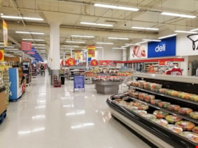
Superstore
https://search.heritageburnaby.ca/link/archivedescription95121
- Repository
- City of Burnaby Archives
- Date
- March 27, 2020
- Collection/Fonds
- Burnaby Photographic Society fonds
- Description Level
- Item
- Physical Description
- 1 photograph (tiff)
- Scope and Content
- Photograph of a near-empty Superstore grocery store at Metropolis at Metrotown Mall.
- Repository
- City of Burnaby Archives
- Date
- March 27, 2020
- Collection/Fonds
- Burnaby Photographic Society fonds
- Physical Description
- 1 photograph (tiff)
- Description Level
- Item
- Record No.
- 623-039
- Access Restriction
- No restrictions
- Reproduction Restriction
- No restrictions
- Accession Number
- 2020-10
- Scope and Content
- Photograph of a near-empty Superstore grocery store at Metropolis at Metrotown Mall.
- Names
- Metrotown
- Media Type
- Photograph
- Photographer
- Cheung, Ray
- Notes
- Transcribed title
- Geographic Access
- Kingsway
- Street Address
- 4700 Kingsway
Images
