Narrow Results By
Subject
- Agriculture 1
- Agriculture - Farms 2
- Arts 1
- Buildings - Commercial - Grocery Stores 1
- Buildings - Commercial - Restaurants 3
- Buildings - Commercial - Service Stations 1
- Buildings - Industrial - Saw Mills 1
- Buildings - Religious - Monasteries 1
- Buildings - Religious - Mosques 1
- Buildings - Schools 10
- Businesses 1
- Businesses - Real Estate Agencies 1
Creator
- Bekins Moving and Storage Company Limited 1
- Binks, James 5
- British Columbia Underwriters' Association 2
- Burnaby Village Museum 17
- Burnett and McGugan B.C. Land Surveyors, New Westminster 5
- Burnett, Geoffrey K. 1
- Burnett & McGugan, Engineers and Surveyors 5
- City Map and White Print Co. 1
- Damer, Eric 5
- Dominion Map and Blueprint Co. 1
- Fleming, Frances "Fanny" Waplington 2
- Fong, Denise 2

Armstrong Street School site
https://search.heritageburnaby.ca/link/museumdescription11133
- Repository
- Burnaby Village Museum
- Date
- 1915
- Collection/Fonds
- Ronald G. Scobbie collection
- Description Level
- Item
- Physical Description
- 1 survey plan : blueprint on paper ; 56 x 54 cm
- Scope and Content
- Survey plan of "Armstrong Street School Site / Burnaby Municipality" "Being a 2 acre portion of Lot 13 Group 1, & according to map 1722 which shows this as Lot E. Block 2 of subdivision of a portion, of Lot 13, Group 1, New Westminster District".
- Repository
- Burnaby Village Museum
- Collection/Fonds
- Ronald G. Scobbie collection
- Description Level
- Item
- Physical Description
- 1 survey plan : blueprint on paper ; 56 x 54 cm
- Material Details
- Scale 40 feet = 1 inch
- Scope and Content
- Survey plan of "Armstrong Street School Site / Burnaby Municipality" "Being a 2 acre portion of Lot 13 Group 1, & according to map 1722 which shows this as Lot E. Block 2 of subdivision of a portion, of Lot 13, Group 1, New Westminster District".
- Creator
- Burnett, Geoffrey K.
- Subjects
- Buildings - Schools
- Names
- Armstrong Avenue School
- Responsibility
- Burnett & McGugan, Engineers and Surveyors
- Geographic Access
- Armstrong Avenue
- Street Address
- 8757 Armstrong Avenue
- Accession Code
- BV003.83.12
- Access Restriction
- No restrictions
- Reproduction Restriction
- No known restrictions
- Date
- 1915
- Media Type
- Cartographic Material
- Historic Neighbourhood
- East Burnaby (Historic Neighbourhood)
- Planning Study Area
- Cariboo-Armstrong Area
- Scan Resolution
- 440
- Scan Date
- 22-Dec-2020
- Scale
- 100
- Notes
- Title based on contents of plan
- Note in black ink on verso of plan reads: "1746"
- Oath on plan reads: "I, Geoffrey K. Burnett...and did personally superintend the survey represented..." "Completed on the 18th day of March 1915"; signed by Geoffrey K. Burnett and notarized by "K.A. Eastman", sworn "...19th day of April 1915"; "Burnett and McGugan., B.C. Land Surveyors. Etc.. New Westminster, B.C.."
Zoomable Images


Barnet School site
https://search.heritageburnaby.ca/link/museumdescription11140
- Repository
- Burnaby Village Museum
- Date
- May 27, 1915
- Collection/Fonds
- Ronald G. Scobbie collection
- Description Level
- Item
- Physical Description
- 1 survey plan : blueprint on paper ; 56 x 54 cm
- Scope and Content
- Survey plan of "Barnet School Site / Burnaby Municipality" "Being a portion of the west half of lot / 214, Group 1 / New Westminster District”.
- Repository
- Burnaby Village Museum
- Collection/Fonds
- Ronald G. Scobbie collection
- Description Level
- Item
- Physical Description
- 1 survey plan : blueprint on paper ; 56 x 54 cm
- Material Details
- Scale 40 feet = 1 inch
- Scope and Content
- Survey plan of "Barnet School Site / Burnaby Municipality" "Being a portion of the west half of lot / 214, Group 1 / New Westminster District”.
- Creator
- McGugan, Donald Johnston
- Subjects
- Buildings - Schools
- Names
- Barnet School
- Responsibility
- Burnett & McGugan, Engineers and Surveyors
- Geographic Access
- Barnet Road
- Street Address
- 7820 Barnet Road
- Accession Code
- BV003.83.19
- Access Restriction
- No restrictions
- Reproduction Restriction
- No known restrictions
- Date
- May 27, 1915
- Media Type
- Cartographic Material
- Historic Neighbourhood
- Barnet (Historic Neighbourhood)
- Planning Study Area
- Burnaby Mountain Area
- Scan Resolution
- 440
- Scan Date
- 22-Dec-2020
- Scale
- 100
- Notes
- Title based on contents of plan
- handwritten on back "Burnaby Schools" "23R" twice, "1783"
- Oath on plan reads: "I, D.J. McGugan...and did personally superintend the survey..." "completed on the 27th day of May 1915"; signed by D.J. McGugan, notarized by "Walter Edmonds" "sworn "...29th day of May 1915" "Burnett and McGugan" "B.C. Land Surveyors Etc. New Westminster, B.C.";
Zoomable Images

![Bird's eye view of New Westminster, Burnaby and Vancouver, [ca. 1911] thumbnail](/media/hpo/_Data/_BVM_Cartographic_Material/1983/1983_0012_0001_002%20Web.jpg?width=280)
Bird's eye view of New Westminster, Burnaby and Vancouver
https://search.heritageburnaby.ca/link/museumdescription8199
- Repository
- Burnaby Village Museum
- Date
- [ca. 1911]
- Collection/Fonds
- Burnaby Village Museum Map collection
- Description Level
- Item
- Physical Description
- 1 map : hand painted ; 65.5 x 99 cm
- Scope and Content
- An untitled monochromatic grayscale map of a developer's bird's eye view looking north west from Burnaby Mountain. View includes Burnaby, New Westminster, Vancouver with the North shore in the distance. Burnaby neighbourhood subdivisions of "Burnaby Heights" and "Buena Vista" are featured near the…
- Repository
- Burnaby Village Museum
- Collection/Fonds
- Burnaby Village Museum Map collection
- Description Level
- Item
- Physical Description
- 1 map : hand painted ; 65.5 x 99 cm
- Scope and Content
- An untitled monochromatic grayscale map of a developer's bird's eye view looking north west from Burnaby Mountain. View includes Burnaby, New Westminster, Vancouver with the North shore in the distance. Burnaby neighbourhood subdivisions of "Burnaby Heights" and "Buena Vista" are featured near the centre of the map. These neighbourhood subdivisions were marketed by Real Estate Agents Liebly & Blumer in 1911. Roads, buildings, factories, railways and bridges are identified on the map.
- Subjects
- Businesses - Real Estate Agencies
- Responsibility
- Leibly & Blumer Realty Co. Incorporated
- Accession Code
- HV983.12.1
- Access Restriction
- No restrictions
- Reproduction Restriction
- No known restrictions
- Date
- [ca. 1911]
- Media Type
- Cartographic Material
- Historic Neighbourhood
- East Burnaby (Historic Neighbourhood)
- Vancouver Heights (Historic Neighbourhood)
- Planning Study Area
- Cariboo-Armstrong Area
- Burnaby Heights Area
- Scan Resolution
- 300
- Scan Date
- December 2020
- Scale
- 100
- Notes
- Title based on contents of map
- Note in pencil on verso of photograph reads: "Make tint block of Buena Vista / Blocks only as shown in lots"
Zoomable Images
![Bird's eye view of New Westminster, Burnaby and Vancouver, [ca. 1911] thumbnail](/media/hpo/_Data/_BVM_Cartographic_Material/1983/1983_0012_0001_001_seadragon/1983_0012_0001_001.jpg?w=280)
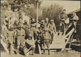
Easter Hike to Crescent
https://search.heritageburnaby.ca/link/museumdescription20571
- Repository
- Burnaby Village Museum
- Date
- 1924
- Collection/Fonds
- David Geoffrey Llewellyn collection
- Description Level
- Item
- Physical Description
- 1 photograph : b&w ; 7.5 x 10 cm
- Scope and Content
- Photograph of a group of Boy Scouts posing together on a wooden structure at Crescent Beach. According to annotations in album, they group were on an Easter Hike to Crescent Beach.
- Repository
- Burnaby Village Museum
- Collection/Fonds
- David Geoffrey Llewellyn collection
- Description Level
- Item
- Physical Description
- 1 photograph : b&w ; 7.5 x 10 cm
- Scope and Content
- Photograph of a group of Boy Scouts posing together on a wooden structure at Crescent Beach. According to annotations in album, they group were on an Easter Hike to Crescent Beach.
- Names
- Boy Scouts of Canada
- Accession Code
- BV995.8.2
- Access Restriction
- No restrictions
- Reproduction Restriction
- No known restrictions
- Date
- 1924
- Media Type
- Photograph
- Scan Resolution
- 600
- Notes
- Title based on contents of photograph
- Photograph is part of photograph album BV995.8.1, pasted to page 1
- Inscription below photograph on page of photograph album BV995.8.1 reads: "Easter Hike to Crescent / 1924"
Images

Documents

Edmonds Street School site
https://search.heritageburnaby.ca/link/museumdescription11125
- Repository
- Burnaby Village Museum
- Date
- March 8, 1915
- Collection/Fonds
- Ronald G. Scobbie collection
- Description Level
- Item
- Physical Description
- 1 survey plan : blueprint on paper ; 56 x 54 cm
- Scope and Content
- Survey plan of "Edmonds Street School Site" "Burnaby Municipality" "Being Lots 28 and 29 of the Subdivision of Lot 30, Group 1, New Westminster District";
- Repository
- Burnaby Village Museum
- Collection/Fonds
- Ronald G. Scobbie collection
- Description Level
- Item
- Physical Description
- 1 survey plan : blueprint on paper ; 56 x 54 cm
- Material Details
- Scale: 4 feet = 1 inch
- Scope and Content
- Survey plan of "Edmonds Street School Site" "Burnaby Municipality" "Being Lots 28 and 29 of the Subdivision of Lot 30, Group 1, New Westminster District";
- Subjects
- Buildings - Schools
- Names
- Edmonds Community School
- Responsibility
- Burnett and McGugan B.C. Land Surveyors, New Westminster
- Geographic Access
- Edmonds Street
- Street Address
- 7641 Edmonds Street
- Accession Code
- BV003.83.5
- Access Restriction
- No restrictions
- Reproduction Restriction
- No known restrictions
- Date
- March 8, 1915
- Media Type
- Cartographic Material
- Historic Neighbourhood
- Edmonds (Historic Neighbourhood)
- Planning Study Area
- Edmonds Area
- Scan Resolution
- 440
- Scan Date
- 22-Dec-2020
- Scale
- 100
- Notes
- Title based on contents of plan
- Oath in bottom left corner reads: "I, D.J. McGugan...and did personally superintend the survey..." "...completed on the 8th day of March 1915"; signed "D.J. McGugan", notarized by "S.F. Mark" "sworn...12th Day of April 1915"
- handwritten on back, "1756"
Zoomable Images


Family and political photograph album
https://search.heritageburnaby.ca/link/museumdescription3654
- Repository
- Burnaby Village Museum
- Date
- 1914-1977
- Collection/Fonds
- Harold Edward Winch collection
- Description Level
- Item
- Physical Description
- 1 album (ca. 85 photographs)
- Scope and Content
- Item is a photograph album containing ca. 85 photographs, including both personal and work-related subjects such as the Winch family and homes, and Winch's political work and travels. Also included are some textual records relating to Winch's political work.
- Repository
- Burnaby Village Museum
- Collection/Fonds
- Harold Edward Winch collection
- Description Level
- Item
- Physical Description
- 1 album (ca. 85 photographs)
- Scope and Content
- Item is a photograph album containing ca. 85 photographs, including both personal and work-related subjects such as the Winch family and homes, and Winch's political work and travels. Also included are some textual records relating to Winch's political work.
- Names
- Winch, Harold Edward
- Winch, Linda Marian Hendy
- Winch, Grace
- Winch, Eileen
- Winch, Ernest "Ernie"
- Winch, Eric
- Co-operative Commonwealth Federation "CCF"
- New Democratic Party
- Douglas, Tommy
- MacInnis, Grace
- Accession Code
- BV013.12.11
- Date
- 1914-1977
- Media Type
- Photograph
- Textual Record
- Notes
- Title based on contents of photograph
- A selection of photographs from scrapbook have been described at item level (BV013.12.36 to BV015.35.117)
Images

Documents
Family photograph album
https://search.heritageburnaby.ca/link/museumdescription3656
- Repository
- Burnaby Village Museum
- Date
- 1972-1979
- Collection/Fonds
- Harold Edward Winch collection
- Description Level
- Item
- Physical Description
- 1 album (ca. 60 photographs)
- Scope and Content
- Item is a photograph album containing ca. 60 photographs, including primarily personal subjects such as family vacations and events, as well as a few photographs relating to Winch's political travels.
- Repository
- Burnaby Village Museum
- Collection/Fonds
- Harold Edward Winch collection
- Description Level
- Item
- Physical Description
- 1 album (ca. 60 photographs)
- Scope and Content
- Item is a photograph album containing ca. 60 photographs, including primarily personal subjects such as family vacations and events, as well as a few photographs relating to Winch's political travels.
- Names
- Winch, Harold Edward
- Accession Code
- BV013.12.13
- Date
- 1972-1979
- Media Type
- Photograph
- Textual Record
- Notes
- Title based on contents of item
Images
Documents

Fire insurance key plan - Greater Vancouver - Volume XIX - Municipality of Burnaby
https://search.heritageburnaby.ca/link/museumdescription17799
- Repository
- Burnaby Village Museum
- Date
- 1927
- Collection/Fonds
- Burnaby Village Museum Map collection
- Description Level
- Item
- Physical Description
- 1 plan on 1 sheet : col. lithographic print ; 64 x 54 cm
- Scope and Content
- Item consists of a one page fire insurance key plan titled "Greater Vancouver / Volume XIX / Municipality / of Burnaby / Key Plan" surveyed May 1927. Key plan from compilation, "Insurance Plans of Greater Vancouver Plan No. 11, Volumes 15 to 19 Burnaby".
- Repository
- Burnaby Village Museum
- Collection/Fonds
- Burnaby Village Museum Map collection
- Description Level
- Item
- Physical Description
- 1 plan on 1 sheet : col. lithographic print ; 64 x 54 cm
- Material Details
- Scale [1:6000]
- Scope and Content
- Item consists of a one page fire insurance key plan titled "Greater Vancouver / Volume XIX / Municipality / of Burnaby / Key Plan" surveyed May 1927. Key plan from compilation, "Insurance Plans of Greater Vancouver Plan No. 11, Volumes 15 to 19 Burnaby".
- Publisher
- Plan Department of Fire Branch of British Columbia Underwriters' Association
- Accession Code
- BV987.1.70
- Access Restriction
- No restrictions
- Reproduction Restriction
- May be restricted by third party rights
- Date
- 1927
- Media Type
- Cartographic Material
- Historic Neighbourhood
- Fraser Arm (Historic Neighbourhood)
- Planning Study Area
- Big Bend Area
- Scan Resolution
- 400
- Scan Date
- 2021-11-17
- Notes
- Title based on contents of item
- Scale 500 feet = 1 inch
- These plans were removed from a bound book with labels on cover page reading: "Plan No. 90 / THIS INSURANCE PLAN / of / Vancouver VOLUME "8" / IN THE PROPERTY OF THE / British Columbia Insurance Underwriter's Association / Vancouver B.C. / AND IS LOANED / MELVILLE F. THOMSON CO. .../ Date May 26th, 1934"; / "Plan No. 74 / THIS INSURANCE PLAN / OF / VANCOUVER VOLUME "9"" / Plan No. 11 / THIS INSURANCE PLAN / OF / BURNABY VOLUMES 15-19" / "THIS PLAN IS THE PROPERTY OF / THE / BRITISH LAW INSURANCE COMPANY / LIMITED"
- Does not include the corresponding key plan page or associated plans numbered 1901 to 1914
- Contact Burnaby Village Museum to view associated fire insurance plans
Zoomable Images

Fire insurance key plan - Greater Vancouver - Volume XIX - Municipality of Burnaby, 1927
Zoom into Image
Fire insurance key plan - Greater Vancouver - Volume XVI - Municipality of Burnaby
https://search.heritageburnaby.ca/link/museumdescription17796
- Repository
- Burnaby Village Museum
- Date
- 1927
- Collection/Fonds
- Burnaby Village Museum Map collection
- Description Level
- Item
- Physical Description
- 2 plans on 2 sheets: col. lithographic print ; 64 x 54 cm
- Scope and Content
- Item consists of a two page fire insurance key plan titled "Greater Vancouver / Volume XVI / Municipality / of Burnaby / Key Plan" surveyed May 1927. Volume XVI includes a two page Key Plan (C and D). .
- Repository
- Burnaby Village Museum
- Collection/Fonds
- Burnaby Village Museum Map collection
- Description Level
- Item
- Physical Description
- 2 plans on 2 sheets: col. lithographic print ; 64 x 54 cm
- Scope and Content
- Item consists of a two page fire insurance key plan titled "Greater Vancouver / Volume XVI / Municipality / of Burnaby / Key Plan" surveyed May 1927. Volume XVI includes a two page Key Plan (C and D). .
- Publisher
- Plan Department of Fire Branch of British Columbia Underwriters Association
- Accession Code
- BV987.1.70
- Access Restriction
- No restrictions
- Reproduction Restriction
- May be restricted by third party rights
- Date
- 1927
- Media Type
- Cartographic Material
- Scan Resolution
- 400
- Scan Date
- 11/17/2021
- Notes
- Title based on contents of item
- Item "GREATER VANCOUVER / VOLUME XVI / MUNICIPALITY OF / BURNABY / KEY PLAN" does not include associated numbered plans (1601 to 1651)
- These plans were removed from a bound book with labels on cover page reading: "Plan No. 90 / THIS INSURANCE PLAN / of / Vancouver VOLUME "8" / IN THE PROPERTY OF THE / British Columbia Insurance Underwriter's Association / Vancouver B.C. / AND IS LOANED / MELVILLE F. THOMSON CO. .../ Date May 26th, 1934"; / "Plan No. 74 / THIS INSURANCE PLAN / OF / VANCOUVER VOLUME "9"" / Plan No. 11 / THIS INSURANCE PLAN / OF / BURNABY VOLUMES 15-19" / "THIS PLAN IS THE PROPERTY OF / THE / BRITISH LAW INSURANCE COMPANY / LIMITED"
Zoomable Images

Fire insurance key plan - Greater Vancouver - Volume XVI - Municipality of Burnaby, 1927
Zoom into Image
Gift album from Israeli government
https://search.heritageburnaby.ca/link/museumdescription3661
- Repository
- Burnaby Village Museum
- Date
- 1959
- Collection/Fonds
- Harold Edward Winch collection
- Description Level
- Item
- Physical Description
- 1 album (180 photographs)
- Scope and Content
- Item is a photograph album received from the Israeli government by Harold as a member of a Canadian Parliamentary delegation visiting Israel in 1959, containing ca. 180 photographs, newspaper clippings, stamps, brochures, and other ephemera relating to Israel and the delegates' visit. The album is …
- Repository
- Burnaby Village Museum
- Collection/Fonds
- Harold Edward Winch collection
- Description Level
- Item
- Physical Description
- 1 album (180 photographs)
- Scope and Content
- Item is a photograph album received from the Israeli government by Harold as a member of a Canadian Parliamentary delegation visiting Israel in 1959, containing ca. 180 photographs, newspaper clippings, stamps, brochures, and other ephemera relating to Israel and the delegates' visit. The album is signed by the Speaker of the Knesset (the Israeli legislature).
- Subjects
- Government - Federal Government
- Names
- Winch, Harold Edward
- Accession Code
- BV013.12.18
- Access Restriction
- No restrictions
- Reproduction Restriction
- May be restricted by third party rights
- Date
- 1959
- Media Type
- Photograph
- Textual Record
- Notes
- Title based on contents of item
Documents

Gilmour Avenue School site
https://search.heritageburnaby.ca/link/museumdescription11129
- Repository
- Burnaby Village Museum
- Date
- May 27, 1915
- Collection/Fonds
- Ronald G. Scobbie collection
- Description Level
- Item
- Physical Description
- 1 survey plan : blueprint on paper ; 56 x 54 cm
- Scope and Content
- Survey plan of Gilmore Avenue School site. Title on plan reads: "Gilmour Avenue School Site / Burnaby Municipality / Being Lots 1-10 inc. & Lots 27-36 inc. of Block 9 / of Subdivision of a Portion of Lot 187, GP.1 / New Westminster District". "Note. School site is as shown below, the original...am…
- Repository
- Burnaby Village Museum
- Collection/Fonds
- Ronald G. Scobbie collection
- Description Level
- Item
- Physical Description
- 1 survey plan : blueprint on paper ; 56 x 54 cm
- Material Details
- Scale: 40 feet = 1 inch
- Scope and Content
- Survey plan of Gilmore Avenue School site. Title on plan reads: "Gilmour Avenue School Site / Burnaby Municipality / Being Lots 1-10 inc. & Lots 27-36 inc. of Block 9 / of Subdivision of a Portion of Lot 187, GP.1 / New Westminster District". "Note. School site is as shown below, the original...amended" "by cancelling Lots 1-10 & 27-30 inc....order of court filed No.4938".
- History
- The school was named after Hugh B. Gilmour, but an error by a municipal clerk in the Street Naming Bylaw in 1912 (Bylaw Number 135) changed the spelling to "Gilmore" Avenue and the school name was spelled "Gilmore" Avenue School hereafter.
- Creator
- McGugan, Donald Johnston
- Subjects
- Buildings - Schools
- Names
- Gilmore Avenue School
- Responsibility
- Burnett & McGugan, Engineers and Surveyors
- Geographic Access
- Gilmore Avenue
- Accession Code
- BV003.83.8
- Access Restriction
- No restrictions
- Reproduction Restriction
- No known restrictions
- Date
- May 27, 1915
- Media Type
- Cartographic Material
- Historic Neighbourhood
- Vancouver Heights (Historic Neighbourhood)
- Planning Study Area
- Willingdon Heights Area
- Scan Resolution
- 440
- Scan Date
- 22-Dec-2020
- Scale
- 100
- Notes
- Transcribed title taken from plan
- Oath in bottom left corner reads: "I, D.J. McGugan...did superintend the survey", "...completed on the 27th day of May 1915" and noterized by Walter Edmonds" "sworn...29th Day of May 1915"; "Burnett and McGugan. B.C. Land Surveyors Etc. New Westminster. B.C."
- Note in black ink on verso of plan reads: "1782"
Zoomable Images

![Highways map of British Columbia, Alberta and adjacent states, [1930] thumbnail](/media/hpo/_Data/_BVM_Cartographic_Material/1977/1977_0037_0187_001.jpg?width=280)
Highways map of British Columbia, Alberta and adjacent states
https://search.heritageburnaby.ca/link/museumdescription9668
- Repository
- Burnaby Village Museum
- Date
- [1930]
- Collection/Fonds
- Burnaby Village Museum Map collection
- Description Level
- Item
- Physical Description
- 1 map : col. lithographic print ; both sides ; 89.5 x 58 cm, folded to 11.5 x 20 cm
- Scope and Content
- Double sided road map published by Imperial Oil, Ltd. and featuring the main travelled highway routes of British Columbia, Alberta and the Northwestern-most states of the United States of America. The map is a colour lithograph. The main map is green, with the highways highlighted in red. The litho…
- Repository
- Burnaby Village Museum
- Collection/Fonds
- Burnaby Village Museum Map collection
- Description Level
- Item
- Physical Description
- 1 map : col. lithographic print ; both sides ; 89.5 x 58 cm, folded to 11.5 x 20 cm
- Material Details
- Scale 1 inch = 20 miles
- A.R. THOMSON / CHIEF CARTOGRAPHER
- Scope and Content
- Double sided road map published by Imperial Oil, Ltd. and featuring the main travelled highway routes of British Columbia, Alberta and the Northwestern-most states of the United States of America. The map is a colour lithograph. The main map is green, with the highways highlighted in red. The lithograph was created in Canada by Rolph Clark Stone Ltd in Toronto. The opposite side of the map features inset maps of the following: the Trans-Canada Highway, the highway between Prince Rupert and Prince George, the highway through the Canadian Rockies, and the highway through the Peace River District. Small city plan maps of highways through major cities, as well as advertisements for Imperial Oil products, are also found on the opposite side of the main map. This map is one of four produced by Imperial Oil that covered the most populated areas of Canada from coast to coast and paralleled Imperial Oil's distribution service.
- Creator
- Thomson, A.R.
- Publisher
- Imperial Oil Limited
- Accession Code
- HV977.37.187
- Access Restriction
- No restrictions
- Reproduction Restriction
- No known restrictions
- Date
- [1930]
- Media Type
- Cartographic Material
- Scan Resolution
- 600
- Scan Date
- 2023-11-10
- Notes
- Title based on content of map
Zoomable Images
![Highways map of British Columbia, Alberta and adjacent states, [1930] thumbnail](/media/hpo/_Data/_BVM_Cartographic_Material/1977/1977_0037_0187_003_seadragon/1977_0037_0187_003.jpg?w=280)


Howard Avenue School site
https://search.heritageburnaby.ca/link/museumdescription11124
- Repository
- Burnaby Village Museum
- Date
- March 24, 1915
- Collection/Fonds
- Ronald G. Scobbie collection
- Description Level
- Item
- Physical Description
- 1 survey plan : blueprint on paper ; 56 x 54 cm
- Scope and Content
- Survey plan of "Howard Avenue School Site" "Burnaby Municipality", "Being Lots 1-5 and 14-18 Inc. Block 5 of the Subd. of Easterly 3/4 of Lot 127. Group 1, New Westminster District";
- Repository
- Burnaby Village Museum
- Collection/Fonds
- Ronald G. Scobbie collection
- Description Level
- Item
- Physical Description
- 1 survey plan : blueprint on paper ; 56 x 54 cm
- Material Details
- Scale: 40 feet = 1 inch
- Scope and Content
- Survey plan of "Howard Avenue School Site" "Burnaby Municipality", "Being Lots 1-5 and 14-18 Inc. Block 5 of the Subd. of Easterly 3/4 of Lot 127. Group 1, New Westminster District";
- Creator
- McGugan, Donald Johnston
- Subjects
- Buildings - Schools
- Names
- Howard Avenue School
- Responsibility
- Burnett and McGugan B.C. Land Surveyors, New Westminster
- Geographic Access
- Howard Avenue
- Georgia Street
- Accession Code
- BV003.83.4
- Access Restriction
- No restrictions
- Reproduction Restriction
- No known restrictions
- Date
- March 24, 1915
- Media Type
- Cartographic Material
- Historic Neighbourhood
- Capitol Hill (Historic Neighbourhood)
- Planning Study Area
- Capitol Hill Area
- Scan Resolution
- 440
- Scan Date
- 22-Dec-2020
- Scale
- 100
- Notes
- Title based on contents of plan
- Oath in bottom left corner reads: "I, D.J. McGugan...and did personally superintend the survey..." "...completed on the 24th day of March 1915"; signed "D.J. McGugan", notarized on April 12th, 1915 by "R. Chapman"
- handwritten on back, "1754"
Zoomable Images

![In and Out of a Cedar Shake Shack, [ca. 2000] thumbnail](/media/hpo/_Data/_BVM_Textual_Records/2016/2016_0046_0051_002.jpg?width=280)
In and Out of a Cedar Shake Shack
https://search.heritageburnaby.ca/link/museumdescription4617
- Repository
- Burnaby Village Museum
- Date
- [ca. 2000]
- Collection/Fonds
- Waplington family fonds
- Description Level
- Item
- Physical Description
- 1 manuscript : 200 pages
- Scope and Content
- Item consists of a copy of an unpublished manuscript titled "In and Out of a Cedar Shake Shack The life of a little girl from World War I to Canada's Diamond Jubilee" written by Frances L. Fleming (nee Waplington).
- Repository
- Burnaby Village Museum
- Collection/Fonds
- Waplington family fonds
- Description Level
- Item
- Physical Description
- 1 manuscript : 200 pages
- Scope and Content
- Item consists of a copy of an unpublished manuscript titled "In and Out of a Cedar Shake Shack The life of a little girl from World War I to Canada's Diamond Jubilee" written by Frances L. Fleming (nee Waplington).
- Other Title Information
- Title continues:... The life of a little girl from World War I to Canada's Diamond Jubilee
- Accession Code
- BV016.46.51
- Access Restriction
- Restricted access
- Reproduction Restriction
- Reproductions subject to FIPPA
- Date
- [ca. 2000]
- Media Type
- Textual Record
- Notes
- Transcribed title
- Experts from this manuscript (pages 113-126) “Christmas Time” and “The Fire Brigade”. have been made available as a pdf. Contact Burnaby Village Museum to view the Manuscript in it's entirety.
Images
![In and Out of a Cedar Shake Shack, [ca. 2000] thumbnail](/media/hpo/_Data/_BVM_Textual_Records/2016/2016_0046_0051_002.jpg)
Documents
![Indexed guide map of the City of Vancouver and suburbs, [1920] thumbnail](/media/hpo/_Data/_BVM_Cartographic_Material/1975/1975_0061_0013_001.jpg?width=280)
Indexed guide map of the City of Vancouver and suburbs
https://search.heritageburnaby.ca/link/museumdescription8678
- Repository
- Burnaby Village Museum
- Date
- [1920]
- Collection/Fonds
- Burnaby Village Museum Map collection
- Description Level
- Item
- Physical Description
- 1 map + textual record : col. lithographic print on paper ; 51.5 x 71 cm folded to 21 x 10 cm
- Scope and Content
- Item consists of a fold out map entitled "Indexed Guide Map of Vancouver and Suburbs" with index. Map includes concentric circles raditating out from Vancouver City Hall on corner of Hastings Street and Main Street; electric railways are indicated by heavy red lines in centres of streets. Includes …
- Repository
- Burnaby Village Museum
- Collection/Fonds
- Burnaby Village Museum Map collection
- Description Level
- Item
- Physical Description
- 1 map + textual record : col. lithographic print on paper ; 51.5 x 71 cm folded to 21 x 10 cm
- Material Details
- Scale [1:47520]
- Index on 4 pages within cardstock cover with advertisements on verso
- Scope and Content
- Item consists of a fold out map entitled "Indexed Guide Map of Vancouver and Suburbs" with index. Map includes concentric circles raditating out from Vancouver City Hall on corner of Hastings Street and Main Street; electric railways are indicated by heavy red lines in centres of streets. Includes old and new street names. Index includes a District Lot Index and Street Index.
- Publisher
- Vancouver Map and Blue Print Company
- Accession Code
- HV975.61.13
- Access Restriction
- No restrictions
- Reproduction Restriction
- No known restrictions
- Date
- [1920]
- Media Type
- Cartographic Material
- Textual Record
- Publisher Series
- 6th edition revised June 1920
- Scan Resolution
- 600
- Scan Date
- 2023-11-10
- Notes
- Title based on contents of map
- Cover of booklet reads: "INDEXED / Guide Map / of the CITY of / VANCOUVER / and / SUBURBS / Compiled and Published by / The Vancouver Map & Blue Print Co. / ...."INTERNATIONAL / BOOK SHOP / Cor. Columbia and Hastings Sts._Vancouver, B.C.".
Documents
Zoomable Images
![Indexed guide map of the City of Vancouver and suburbs, [1920] thumbnail](/media/hpo/_Data/_BVM_Cartographic_Material/1975/1975_0061_0013_002_seadragon/1975_0061_0013_002.jpg?w=280)

Indexed guide map of the city of Vancouver and Suburbs
https://search.heritageburnaby.ca/link/museumdescription8694
- Repository
- Burnaby Village Museum
- Date
- 1914
- Collection/Fonds
- Burnaby Village Museum Map collection
- Description Level
- Item
- Physical Description
- 1 map + textual record : col. lithographic print on paper ; 55 x 78 cm on sheet 58.5 x 82 cm folded to 20 x 10 cm
- Scope and Content
- Item consists of a map "Indexed Guide Map of the City of Vancouver and Suburbs compiled and published by The Vancouver Map and Blueprint Co. Ltd. Map shows district lots, blocks and boundaries between City of Vancouver, Point Grey, South Vancouver, Burnaby, New Westminster and parts of Richmond, No…
- Repository
- Burnaby Village Museum
- Collection/Fonds
- Burnaby Village Museum Map collection
- Description Level
- Item
- Physical Description
- 1 map + textual record : col. lithographic print on paper ; 55 x 78 cm on sheet 58.5 x 82 cm folded to 20 x 10 cm
- Material Details
- Scale not defined
- Map is folded into booklet form
- Scope and Content
- Item consists of a map "Indexed Guide Map of the City of Vancouver and Suburbs compiled and published by The Vancouver Map and Blueprint Co. Ltd. Map shows district lots, blocks and boundaries between City of Vancouver, Point Grey, South Vancouver, Burnaby, New Westminster and parts of Richmond, North Vancouver and West Vancouver. Concentric cirlces indicate the distance in miles from the intersection of Main Street and Hastings Street, Vancouver in intervals of 1/2 mile. Map is folded into booklet form and includes a four page index with cardstock cover. Index page 1 is titled "Hotels"; page 2 is titled "District Lot Index"; pages 3-8 "Street Index".
- Publisher
- Vancouver Map and Blueprint Company Limited
- Edition
- 5th Edition revised to June 1914
- Geographic Access
- Vancouver
- Accession Code
- HV983.9.18
- Date
- 1914
- Media Type
- Cartographic Material
- Scan Resolution
- 600
- Scan Date
- 2023-08-17
- Notes
- Transcribed title from map and cover
- Sticker adhered to front cover of index of two lions "Service / "WE GIVE IT" / WESTERN SPECIALTY / LIMITED/ STATIONERS AND PRINTERS / VANCOUVER - B.C."
Documents
Zoomable Images

![Indexed map of Greater Vancouver, [193-] thumbnail](/media/hpo/_Data/_BVM_Cartographic_Material/1976/1976_0026_0001_001.jpg?width=280)
Indexed map of Greater Vancouver
https://search.heritageburnaby.ca/link/museumdescription8201
- Repository
- Burnaby Village Museum
- Date
- [193-]
- Collection/Fonds
- Burnaby Village Museum Map collection
- Description Level
- Item
- Physical Description
- 1 map + 1 p. textual records : b&w lithographic print on 1 sheet ; 46 x 41 cm folded to 23 x 10 cm
- Scope and Content
- Item consists of a promotional brochure for Bekins Moving and Storage, with an indexed map of Greater Vancouver showing distances from the Bekins building located at Pender Street and Beatty Street on one side, and text and images advertising the company's services and facilities on the other side.…
- Repository
- Burnaby Village Museum
- Collection/Fonds
- Burnaby Village Museum Map collection
- Description Level
- Item
- Physical Description
- 1 map + 1 p. textual records : b&w lithographic print on 1 sheet ; 46 x 41 cm folded to 23 x 10 cm
- Material Details
- Scale not defined
- Printing on two sides of sheet
- Folded into eight sections
- Scope and Content
- Item consists of a promotional brochure for Bekins Moving and Storage, with an indexed map of Greater Vancouver showing distances from the Bekins building located at Pender Street and Beatty Street on one side, and text and images advertising the company's services and facilities on the other side. Cover of folded map reads "Indexed Map of Greater Vancouver / The Great Northwest for Opportunity / Compliments of / Bekins Moving and / Storage Co.".
- Responsibility
- Bekins Moving and Storage Company Limited
- Accession Code
- HV976.26.1
- Access Restriction
- No restrictions
- Reproduction Restriction
- No known restrictions
- Date
- [193-]
- Media Type
- Cartographic Material
- Textual Record
- Scan Resolution
- 600
- Scan Date
- 2023-08-17
- Notes
- Title based on contents of map
Zoomable Images
![Indexed map of Greater Vancouver, [193-] thumbnail](/media/hpo/_Data/_BVM_Cartographic_Material/1976/1976_0026_0001_001_seadragon/1976_0026_0001_001.jpg?w=280)

Inman Avenue School site
https://search.heritageburnaby.ca/link/museumdescription11128
- Repository
- Burnaby Village Museum
- Date
- May 3, 1915
- Collection/Fonds
- Ronald G. Scobbie collection
- Description Level
- Item
- Physical Description
- 1 survey plan : blueprint on paper ; 56 x 54 cm
- Scope and Content
- Survey plan of "Inman Avenue School Site" "Burnaby Municipality" "Being Lots 3 -12 inc. Blk. C. of Subd. of Blks.5" "13-19 inc. & 21-28 inc. of Subd. of Westerly 80 Acres of, and portion of D.L. 34, Group One. New Westminster District".
- Repository
- Burnaby Village Museum
- Collection/Fonds
- Ronald G. Scobbie collection
- Description Level
- Item
- Physical Description
- 1 survey plan : blueprint on paper ; 56 x 54 cm
- Material Details
- Scale: 40 feet = 1 inch
- Scope and Content
- Survey plan of "Inman Avenue School Site" "Burnaby Municipality" "Being Lots 3 -12 inc. Blk. C. of Subd. of Blks.5" "13-19 inc. & 21-28 inc. of Subd. of Westerly 80 Acres of, and portion of D.L. 34, Group One. New Westminster District".
- Creator
- McGugan, Donald Johnston
- Subjects
- Buildings - Schools
- Names
- Inman Avenue School
- Responsibility
- Burnett & McGugan, Engineers and Surveyors
- Geographic Access
- Brandon Street
- Street Address
- 3963 Brandon Street
- Accession Code
- BV003.83.7
- Access Restriction
- No restrictions
- Reproduction Restriction
- No known restrictions
- Date
- May 3, 1915
- Media Type
- Cartographic Material
- Historic Neighbourhood
- Central Park (Historic Neighbourhood)
- Planning Study Area
- Garden Village Area
- Scan Resolution
- 440
- Scan Date
- 22-Dec-2020
- Scale
- 100
- Notes
- Title based on contents of plan
- Oath in bottom left corner reads: "I, D.J. McGugan...did...superintend the survey...", "...completed on the 3rd day of May 1915"; signed "D.J. McGugan", notariz- ed by "Walter Edmonds" "sworn...22nd Day of May 1915"; "Burnett and McGugan. B.C. Land Surveyors. Etc. New Westminster. B.C.";
- handwritten note reads: "Note: Before using this Mon. see plan / of resubdivision of Lots 5 & 6 / of Block 'B' D.L. 34 / June 1945"
- handwritten twice on back, "1776"
Zoomable Images

Interview with Bill Gruenthal
https://search.heritageburnaby.ca/link/museumdescription19636
- Repository
- Burnaby Village Museum
- Date
- [1950-2023] (interview content), interviewed 31 Jul. 2023
- Collection/Fonds
- Burnaby Village Museum fonds
- Description Level
- Item
- Physical Description
- 2 sound recordings (wav) (74 min., 37 sec.) + 1 sound recording (mp3) (74 min., 37 sec.)
- Scope and Content
- Item consists of a recording of an oral history interview with Bill Gruenthal conducted by Burnaby Village Museum Registrar, Eric Damer on July 31 2023. 00:00:00 – 00:27:01 Bill Gruenthal provides details on his family background, his early life experiences, how he got into the insurance business,…
- Repository
- Burnaby Village Museum
- Collection/Fonds
- Burnaby Village Museum fonds
- Series
- Museum Oral Histories series
- Subseries
- Many Voices Project Interviews subseries
- Description Level
- Item
- Physical Description
- 2 sound recordings (wav) (74 min., 37 sec.) + 1 sound recording (mp3) (74 min., 37 sec.)
- Material Details
- Interviewer: Eric Damer Interviewee: Bill Gruenthal Location of Interview: Burnaby Village Museum Interview Date: July 31, 2023 Total Number of tracks: 1 Total Length of all Tracks: 01:14:37 Digital master recordings (wav) were recorded onto two separate audio tracks, edited and merged together and converted to mp3 for access on Heritage Burnaby
- Scope and Content
- Item consists of a recording of an oral history interview with Bill Gruenthal conducted by Burnaby Village Museum Registrar, Eric Damer on July 31 2023. 00:00:00 – 00:27:01 Bill Gruenthal provides details on his family background, his early life experiences, how he got into the insurance business, his knowledge and interest in Judaism, places that he and his wife lived before moving to Burnaby, family life in Burnaby and his political involvement in running for the Burnaby school board. 00:27:02 – 00:42:50 Bill Gruenthal talks about the Burquest Jewish Community Association, it’s background and his involvement, experiences of discrimination in his career, a brief history of the Jewish people and some cultural traditions. 00:42:51 – 00:56:04 Bill Gruenthal mentions some of the charities that he supports including Burnaby Hospital, his volunteer work within the community and community organizations including the Nikkei Place Foundation and shares more details on his insurance career. 00:56:05 – 01:14:37 Bill Gruenthal shares information about his Burnaby neighbourhood and Jewish funeral customs and provides his impressions of new development at Brentwood, Burnaby Council and other development projects in Burnaby.
- History
- Interviewee biography: Bill Gruenthal was born in the British Mandate of Palestine, now Israel, in 1935 after his parents had fled Germany in advance of the then worsening political situation. Bill’s father died in 1942; some years later his mother remarried to an Irish-born senior civil servant in that government. He had a difficult and somewhat dangerous job. Soon after marriage, the family, including Bill’s older brother, Martin, immigrated to Canada in January 1947 on the strength of his step-father’s British Passport. They traveled via New York, where Bill’s uncle and his family resided and who put up the family. Later that month, the parents travelled by CP rail from Montreal to Vancouver, followed by Bill and his brother in March 1947 who travelled from New York to White Rock on an American railroad. While passing through the Fraser Valley Bill’s parents took an interest in Silverdale, a small hamlet west of Mission where the four eventually settled. Bill finished High School in Mission and soon joined the insurance industry. Bill connected with the Jewish Community in Vancouver where he met his soon-to-be wife. Upon marriage they were transferred to Calgary; after five years suffering its cold weather they were transferred back to Vancouver. They settled in Burnaby in 1966 as an affordable neighbourhood with easy access to his office downtown Vancouver. Outside work, Bill helped raise his family of three daughters who all graduated Burnaby High School (Alpha). They joined Temple Sholom in Vancouver, and he volunteered and still volunteers for a number of non-profits, including The Jewish Museum and Archives and Nikkei Place Foundation (Burnaby). He was an early long-term supporter and a past president of Burquest Jewish Community Association, mostly involving persons from Burnaby, New Westminster, and the Tri-Cities area (hence the name). He ran for political office in Burnaby in 1976 but was not elected. He delivers food in Burnaby for the Food Bank and is a donor to many worthy causes including Burnaby General Hospital. Interviewer biography: Eric Damer is a Burnaby Village Museum Interpreter, Museum Registrar, Researcher and Blacksmith. Eric pounded hot steel for the first time in 1977 in junior high. Fifteen years later, he joined Burnaby Village Museum where he has smithed for three decades. He also provides historical research for museum exhibits and special projects. Outside the museum, Eric is a social historian with a special interest in educational history.
- Creator
- Burnaby Village Museum
- Subjects
- Migration
- Persons - Jewish Canadians
- Transportation
- Transportation - Rail
- Religions - Judaism
- Cemeteries
- Organizations
- Elections
- Names
- Gruenthal, Bill
- Gruenthal, Noemi Yadlow
- O'Connor, Herta Ingrid Gruenthal
- O'Connor, John
- Burquest
- Jacobson, Max Alec
- Temple Shalom
- Brentwood Shopping Centre
- Brentwood Park School
- Alpha Secondary School
- Burnaby School Board
- Responsibility
- Damer, Eric
- Accession Code
- BV023.16.14
- Access Restriction
- No restrictions
- Reproduction Restriction
- No known restrictions
- Date
- [1950-2023] (interview content), interviewed 31 Jul. 2023
- Media Type
- Sound Recording
- Planning Study Area
- Brentwood Area
- Notes
- Title based on contents of item
- Transcription available
Documents
Audio Tracks
Interview with Bill Gruenthal, [1950-2023] (interview content), interviewed 31 Jul. 2023
Interview with Bill Gruenthal, [1950-2023] (interview content), interviewed 31 Jul. 2023
https://search.heritageburnaby.ca/media/hpo/_Data/_BVM_Sound_Recordings/Oral_Histories/2023_0016_0014_003.mp3Interview with David Skulski
https://search.heritageburnaby.ca/link/museumdescription19606
- Repository
- Burnaby Village Museum
- Date
- [1948-2023] (interview content), interviewed 6 Jul. 2023
- Collection/Fonds
- Burnaby Village Museum fonds
- Description Level
- Item
- Physical Description
- 2 sound recordings (wav) (80 min., 38 sec.) + 1 sound recording (mp3) (80 min., 38 sec.)
- Scope and Content
- Item consists of a recording of an oral history interview with Murray "David" Skulski conducted by Burnaby Village Museum Registrar and Researcher, Eric Damer. 00:00:00 – 00:22:22 David Skulski provides biographical information about himself. He talks about his childhood experiences growing up, at…
- Repository
- Burnaby Village Museum
- Collection/Fonds
- Burnaby Village Museum fonds
- Series
- Museum Oral Histories series
- Subseries
- Many Voices Project Interviews subseries
- Description Level
- Item
- Physical Description
- 2 sound recordings (wav) (80 min., 38 sec.) + 1 sound recording (mp3) (80 min., 38 sec.)
- Material Details
- Interviewer: Eric Damer Interviewee: David Skulski Location of Interview: Burnaby Village Museum Interview Date: July 6 2023 Total Number of tracks: 2 Total Length of all Tracks: 80 min., 38 sec. Digital master recordings (wav) were recorded onto two separate audio tracks, edited and merged together and converted to mp3 for access on Heritage Burnaby
- Scope and Content
- Item consists of a recording of an oral history interview with Murray "David" Skulski conducted by Burnaby Village Museum Registrar and Researcher, Eric Damer. 00:00:00 – 00:22:22 David Skulski provides biographical information about himself. He talks about his childhood experiences growing up, attending school in New Westminster and Burnaby and Hebrew school in Vancouver. David recalls his early experiences in music, instruments that he played and describes some of his Jewish family traditions. 00:22:23 – 00:49:57 David talks about his experiences studying music at university and following his passion as a musician and oboist. He recalls his experiences of working with the Vancouver Symphony Orchestra, the CBC Orchestra, Vancouver Society for Early Music, the Burnaby Symphony Orchestra, other musical ensembles and venues where he’s performed. 00:49:58 – 01:00:00 David talks about living in Burnaby in the Deer Lake neighbourhood. David describes some his experiences playing traditional music from different countries. 01:01:01 – 01:14:15 David comments on the changes that he’s seen in Burnaby over the years, some of his favourite places, activities, cultural amenities and development on the Fraser River. David talks about the Jewish community in Burnaby, his involvement with the Peretz Centre and examples of Jewish cuisine. 01:14:16 – 01:20:38 David talks about Yiddish being his first language, his language studies in Lithuania, the roots of the language and provides some examples of speaking Yiddish.
- History
- Interviewee biography: Murray "David" Skulski was born in 1942 in Moose Jaw, Saskatchewan and moved to British Columbia with his parents in 1948. Skulski and his family settled in New Westminster before moving to Burnaby in the late 1950's. Skulski took piano lessons at an early age and began playing obo while attending junior high school in New Westminster. In 1960 at the age of 17 years, Skulski began performing with the Vancouver Symphony Orchestra as solo English horn and is the youngest player to ever be employed with the VSO. In 1991, Skulski started playing with the Vancouver Folk Orchestra and was the conductor between 1997 and 2004. Skulski has been the principal oboe player in many orchestras. In 1968, Skulski founded the Hortulani Musicae; in 1970, he founded the Vancouver Society for Early Music and in 1983 he founded Harmonie, an ensemble concentrating in classical wind music. In 2003, Skulski became president of the Pertez Centre for Secular Jewish Culture. In 2005, Skulski became principal oboist of the Philharmonic Orchestra and the Burnaby Symphony Orchestra and between 2009 and 2019 he was the principal oboist for the Pilgrim Orchestra under Pilwon Suk. David has served as president of the Peretz Centre for Secular Jewish Culture and since 2022, he’s served on the board of the Vancouver Chamber Music Society. Skulski has taught summer courses in Renaissance music in Austria (1972-1979), has been a music resident at Simon Fraser University (1973-1976), has lectured on the history of musical instruments at SFU and UBC and in 2008 began teaching at the Pacific Coast School of Music, Richmond School of Music and Oakridge Music Studios. Interviewer biography: Eric Damer is a Burnaby Village Museum Interpreter, Museum Registrar, Researcher and Blacksmith. Eric pounded hot steel for the first time in 1977 in junior high. Fifteen years later, he joined Burnaby Village Museum where he has smithed for three decades. He also provides historical research for museum exhibits and special projects. Outside the museum, Eric is a social historian with a special interest in educational history.
- Creator
- Burnaby Village Museum
- Subjects
- Education
- Foods
- Music
- Musical Instruments
- Occupations - Musicians
- Performances - Concerts
- Persons - Jewish Canadians
- Religions - Judaism
- Names
- Burnaby Symphony Orchestra
- Burnaby South High School
- Burquest
- Skulski, Murray "David"
- Vancouver Symphony Orchestra
- Vancouver Society for Early Music
- Peretz Centre
- Responsibility
- Damer, Eric
- Geographic Access
- Deer Lake
- Deer Lake Park
- Accession Code
- BV023.16.10
- Access Restriction
- No restrictions
- Reproduction Restriction
- No known restrictions
- Date
- [1948-2023] (interview content), interviewed 6 Jul. 2023
- Media Type
- Sound Recording
- Historic Neighbourhood
- Burnaby Lake (Historic Neighbourhood)
- Planning Study Area
- Douglas-Gilpin Area
- Notes
- Title based on contents of item
- Transcription available
Documents
Audio Tracks
Interview with David Skulski, [1948-2023] (interview content), interviewed 6 Jul. 2023
Interview with David Skulski, [1948-2023] (interview content), interviewed 6 Jul. 2023
https://search.heritageburnaby.ca/media/Hpo/_Data/_BVM_Sound_Recordings/Oral_Histories/2023_0016_0010_003.mp3