More like 'Interview with Barry Jones by Kathy Bossort December 9, 2015 - Track 2'
Narrow Results By
Subject
- Accidents 1
- Accidents - Automobile Accidents 1
- Advertising Medium - Signs and Signboards 37
- Aerial Photographs 36
- Agricultural Tools and Equipment 2
- Agricultural Tools and Equipment - Gardening Equipment 4
- Agricultural Tools and Equipment - Plows 2
- Agriculture 3
- Agriculture - Farms 12
- Agriculture - Fruit and Berries 2
- Animals 4
- Animals - Bears 2

Burnaby's COVID-19 drive thru testing site
https://search.heritageburnaby.ca/link/museumdescription15391
- Repository
- Burnaby Village Museum
- Date
- 27 Apr. 2020
- Collection/Fonds
- Burnaby Village Museum COVID-19 collection
- Description Level
- Item
- Physical Description
- 1 video recording (mp4) (17 sec.) : digital, 24 fps, col., si.
- Scope and Content
- Film clip (no sound) of the COVID-19 drive thru testing site in Central Park parking lot in Burnaby. Orange traffic posts, wayfinding signs and white tents are set up in the parking lot and staff are wearing protective face masks.
- Repository
- Burnaby Village Museum
- Collection/Fonds
- Burnaby Village Museum COVID-19 collection
- Description Level
- Item
- Physical Description
- 1 video recording (mp4) (17 sec.) : digital, 24 fps, col., si.
- Scope and Content
- Film clip (no sound) of the COVID-19 drive thru testing site in Central Park parking lot in Burnaby. Orange traffic posts, wayfinding signs and white tents are set up in the parking lot and staff are wearing protective face masks.
- Subjects
- Advertising Medium - Signs and Signboards
- Geographic Features - Parks
- Public Services - Health Services
- Pandemics - COVID-19
- Geographic Access
- Central Park
- Imperial Street
- Accession Code
- BV021.2.8
- Access Restriction
- No restrictions
- Reproduction Restriction
- May be restricted by third party rights
- Date
- 27 Apr. 2020
- Media Type
- Moving Images
- Historic Neighbourhood
- Central Park (Historic Neighbourhood)
- Planning Study Area
- Maywood Area
- Notes
- Title based on contents of photograph
Images

Video
Burnaby's COVID-19 drive thru testing site, 27 Apr. 2020
Burnaby's COVID-19 drive thru testing site, 27 Apr. 2020
https://search.heritageburnaby.ca/media/hpo/_Data/_BVM_Moving_Images/2021_0002_0008_001.mp4
Costco happy shopper
https://search.heritageburnaby.ca/link/archivedescription95082
- Repository
- City of Burnaby Archives
- Date
- June 13, 2020
- Collection/Fonds
- Burnaby Photographic Society fonds
- Description Level
- Item
- Physical Description
- 1 photograph (tiff)
- Scope and Content
- Photograph of a woman wearing a black face mask, standing with a shopping cart full of groceries in a Costco parking lot.
- Repository
- City of Burnaby Archives
- Date
- June 13, 2020
- Collection/Fonds
- Burnaby Photographic Society fonds
- Physical Description
- 1 photograph (tiff)
- Description Level
- Item
- Record No.
- 623-001
- Access Restriction
- No restrictions
- Reproduction Restriction
- No restrictions
- Accession Number
- 2020-10
- Scope and Content
- Photograph of a woman wearing a black face mask, standing with a shopping cart full of groceries in a Costco parking lot.
- Media Type
- Photograph
- Photographer
- Gervan, Bonnie
- Notes
- Transcribed title
- Photographer's caption: "I asked this friendly woman if I could take her photo, as she was on her way to her car with her groceries."
- Geographic Access
- Still Creek Avenue
- Street Address
- 4500 Still Creek Avenue
- Planning Study Area
- Dawson-Delta Area
Images


Do Your Part Eagle
https://search.heritageburnaby.ca/link/archivedescription95084
- Repository
- City of Burnaby Archives
- Date
- June 13, 2020
- Collection/Fonds
- Burnaby Photographic Society fonds
- Description Level
- Item
- Physical Description
- 1 photograph (tiff)
- Scope and Content
- Photograph of a sign along the Burnaby Lake Freeway Trail that reads: "Do your part. Stay 2 metres apart." The sign has a silhoutte drawing of an eagle with its wings open to illustrate the distance of two metres.
- Repository
- City of Burnaby Archives
- Date
- June 13, 2020
- Collection/Fonds
- Burnaby Photographic Society fonds
- Physical Description
- 1 photograph (tiff)
- Description Level
- Item
- Record No.
- 623-003
- Access Restriction
- No restrictions
- Reproduction Restriction
- No restrictions
- Accession Number
- 2020-10
- Scope and Content
- Photograph of a sign along the Burnaby Lake Freeway Trail that reads: "Do your part. Stay 2 metres apart." The sign has a silhoutte drawing of an eagle with its wings open to illustrate the distance of two metres.
- Media Type
- Photograph
- Photographer
- Gervan, Bonnie
- Notes
- Transcribed title
- Photographer's caption: "A sign shows how far to keep apart."
- Geographic Access
- Burnaby Lake Regional Nature Park
- Historic Neighbourhood
- Burnaby Lake (Historic Neighbourhood)
- Planning Study Area
- Burnaby Lake Area
Images


More Covid Litter
https://search.heritageburnaby.ca/link/archivedescription95091
- Repository
- City of Burnaby Archives
- Date
- June 6, 2020
- Collection/Fonds
- Burnaby Photographic Society fonds
- Description Level
- Item
- Physical Description
- 1 photograph (tiff)
- Scope and Content
- Photograph of two discarded purple nitrile gloves in the Metrotown parking lot on Kingsway.
- Repository
- City of Burnaby Archives
- Date
- June 6, 2020
- Collection/Fonds
- Burnaby Photographic Society fonds
- Physical Description
- 1 photograph (tiff)
- Description Level
- Item
- Record No.
- 623-010
- Access Restriction
- No restrictions
- Reproduction Restriction
- Reproduce for fair dealing purposes only
- Accession Number
- 2020-10
- Scope and Content
- Photograph of two discarded purple nitrile gloves in the Metrotown parking lot on Kingsway.
- Media Type
- Photograph
- Photographer
- Asbia, Cher
- Notes
- Transcribed title
- Geographic Access
- Kingsway
- Historic Neighbourhood
- Central Park (Historic Neighbourhood)
- Planning Study Area
- Maywood Area
Images


Social distance in Burnaby Parks
https://search.heritageburnaby.ca/link/archivedescription95093
- Repository
- City of Burnaby Archives
- Date
- May 8, 2020
- Collection/Fonds
- Burnaby Photographic Society fonds
- Description Level
- Item
- Physical Description
- 1 photograph (tiff)
- Scope and Content
- Photograph of a City of Burnaby sign encouraging social distancing attached to a tree in Mary Avenue Park.
- Repository
- City of Burnaby Archives
- Date
- May 8, 2020
- Collection/Fonds
- Burnaby Photographic Society fonds
- Physical Description
- 1 photograph (tiff)
- Description Level
- Item
- Record No.
- 623-012
- Access Restriction
- No restrictions
- Reproduction Restriction
- Reproduce for fair dealing purposes only
- Accession Number
- 2020-10
- Scope and Content
- Photograph of a City of Burnaby sign encouraging social distancing attached to a tree in Mary Avenue Park.
- Media Type
- Photograph
- Photographer
- Asbia, Cher
- Notes
- Transcribed title
- Geographic Access
- 12th Avenue
- Historic Neighbourhood
- Edmonds (Historic Neighbourhood)
- Planning Study Area
- Edmonds Area
Images


Burnaby hospital closes main entrance
https://search.heritageburnaby.ca/link/archivedescription95094
- Repository
- City of Burnaby Archives
- Date
- April 6, 2020
- Collection/Fonds
- Burnaby Photographic Society fonds
- Description Level
- Item
- Physical Description
- 1 photograph (tiff)
- Scope and Content
- Photograph of a rerouting sign posted to a sandwich board outside the Burnaby Hospital emergency lot. The sign states that the hospital entrance is closed and requests visitors use the Main Entrance of the hospital.
- Repository
- City of Burnaby Archives
- Date
- April 6, 2020
- Collection/Fonds
- Burnaby Photographic Society fonds
- Physical Description
- 1 photograph (tiff)
- Description Level
- Item
- Record No.
- 623-013
- Access Restriction
- No restrictions
- Reproduction Restriction
- No restrictions
- Accession Number
- 2020-10
- Scope and Content
- Photograph of a rerouting sign posted to a sandwich board outside the Burnaby Hospital emergency lot. The sign states that the hospital entrance is closed and requests visitors use the Main Entrance of the hospital.
- Subjects
- Buildings - Civic - Hospitals
- Geographic Features - Automobile Parking Lots
- Advertising Medium - Signs and Signboards
- Media Type
- Photograph
- Photographer
- Damer, Eric
- Notes
- Transcribed title
- Geographic Access
- Kincaid Street
- Street Address
- 3935 Kincaid Street
- Historic Neighbourhood
- Broadview (Historic Neighbourhood)
- Planning Study Area
- Cascade-Schou Area
Images


Swangard Stadium closed
https://search.heritageburnaby.ca/link/archivedescription95096
- Repository
- City of Burnaby Archives
- Date
- April 21, 2020
- Collection/Fonds
- Burnaby Photographic Society fonds
- Description Level
- Item
- Physical Description
- 1 photograph (tiff)
- Scope and Content
- Photograph of two City of Burnaby signs attached to fencing outside Swangard Stadium in Central Park. The signs announce the facility's closure in response to the COVID-19 pandemic. Behind the fencing, the stadium's track and bleachers are visible.
- Repository
- City of Burnaby Archives
- Date
- April 21, 2020
- Collection/Fonds
- Burnaby Photographic Society fonds
- Physical Description
- 1 photograph (tiff)
- Description Level
- Item
- Record No.
- 623-015
- Access Restriction
- No restrictions
- Reproduction Restriction
- No restrictions
- Accession Number
- 2020-10
- Scope and Content
- Photograph of two City of Burnaby signs attached to fencing outside Swangard Stadium in Central Park. The signs announce the facility's closure in response to the COVID-19 pandemic. Behind the fencing, the stadium's track and bleachers are visible.
- Names
- Swangard Stadium
- Media Type
- Photograph
- Photographer
- Damer, Eric
- Notes
- Transcribed title
- Geographic Access
- Central Park
- Imperial Street
- Street Address
- 3883 Imperial Street
- Historic Neighbourhood
- Central Park (Historic Neighbourhood)
- Planning Study Area
- Maywood Area
Images


Central Park testing station
https://search.heritageburnaby.ca/link/archivedescription95101
- Repository
- City of Burnaby Archives
- Date
- May 9, 2020
- Collection/Fonds
- Burnaby Photographic Society fonds
- Description Level
- Item
- Physical Description
- 1 photograph (tiff)
- Scope and Content
- Photograph of the COVID-19 testing station located in the Central Park parking lot off Boundary Road. A sign in the foreground reads "Covid-19 Care Site by Referral Only / Walk in Access". In the background, the white tents of the testing station are visible.
- Repository
- City of Burnaby Archives
- Date
- May 9, 2020
- Collection/Fonds
- Burnaby Photographic Society fonds
- Physical Description
- 1 photograph (tiff)
- Description Level
- Item
- Record No.
- 623-019
- Access Restriction
- No restrictions
- Reproduction Restriction
- No restrictions
- Accession Number
- 2020-10
- Scope and Content
- Photograph of the COVID-19 testing station located in the Central Park parking lot off Boundary Road. A sign in the foreground reads "Covid-19 Care Site by Referral Only / Walk in Access". In the background, the white tents of the testing station are visible.
- Subjects
- Geographic Features - Parks
- Geographic Features - Automobile Parking Lots
- Advertising Medium - Signs and Signboards
- Structures - Tents
- Media Type
- Photograph
- Photographer
- Damer, Eric
- Notes
- Transcribed title
- Geographic Access
- Boundary Road
- Central Park
- Historic Neighbourhood
- Central Park (Historic Neighbourhood)
- Planning Study Area
- Maywood Area
Images


Physical distancing sign
https://search.heritageburnaby.ca/link/archivedescription95106
- Repository
- City of Burnaby Archives
- Date
- 2020
- Collection/Fonds
- Burnaby Photographic Society fonds
- Description Level
- Item
- Physical Description
- 1 photograph (tiff)
- Scope and Content
- Photograph of the gardens outside the Shadbolt Centre of the Arts. In the foreground, attached to a tree is a sign encouraging social distancing; in the background is a jungle gym fenced off with orange mesh and caution tape to prohibit climbing.
- Repository
- City of Burnaby Archives
- Date
- 2020
- Collection/Fonds
- Burnaby Photographic Society fonds
- Physical Description
- 1 photograph (tiff)
- Description Level
- Item
- Record No.
- 623-024
- Access Restriction
- No restrictions
- Reproduction Restriction
- No restrictions
- Accession Number
- 2020-10
- Scope and Content
- Photograph of the gardens outside the Shadbolt Centre of the Arts. In the foreground, attached to a tree is a sign encouraging social distancing; in the background is a jungle gym fenced off with orange mesh and caution tape to prohibit climbing.
- Media Type
- Photograph
- Photographer
- King, Gloria
- Notes
- Transcribed title
- Geographic Access
- Deer Lake
- Street Address
- 6450 Deer Lake Avenue
- Historic Neighbourhood
- Burnaby Lake (Historic Neighbourhood)
- Planning Study Area
- Douglas-Gilpin Area
Images


Temporary one way at Deer Lake Park
https://search.heritageburnaby.ca/link/archivedescription95111
- Repository
- City of Burnaby Archives
- Date
- April 10, 2020
- Collection/Fonds
- Burnaby Photographic Society fonds
- Description Level
- Item
- Physical Description
- 1 photograph (tiff)
- Scope and Content
- Photograph of a sign detailing a temporary one-way walking route for Deer Lake Park. The sign is posted at the Royal Oak entrance of the park.
- Repository
- City of Burnaby Archives
- Date
- April 10, 2020
- Collection/Fonds
- Burnaby Photographic Society fonds
- Physical Description
- 1 photograph (tiff)
- Description Level
- Item
- Record No.
- 623-029
- Access Restriction
- No restrictions
- Reproduction Restriction
- No restrictions
- Accession Number
- 2020-10
- Scope and Content
- Photograph of a sign detailing a temporary one-way walking route for Deer Lake Park. The sign is posted at the Royal Oak entrance of the park.
- Media Type
- Photograph
- Photographer
- Snowdon, Nick
- Notes
- Transcribed title
- Photographer's caption: "Big signs show the one way system at Deer Lake. The signs are not detailed and lead to some confusion. Other signs are spread throughout the park including spay paint on the trails."
- Geographic Access
- Deer Lake Park
- Planning Study Area
- Windsor Area
Images


Deer Lake parking lot off limits
https://search.heritageburnaby.ca/link/archivedescription95113
- Repository
- City of Burnaby Archives
- Date
- June 26, 2020
- Collection/Fonds
- Burnaby Photographic Society fonds
- Description Level
- Item
- Physical Description
- 1 photograph (tiff)
- Scope and Content
- Photograph of the Deer Lake Park parking lot at the Royal Oak entrance. The entrance to the lot is blocked off with two orange traffic barriers. In the distance, a sign detailing a temporary one-way walking route for the park and a man walking into the park are visible.
- Repository
- City of Burnaby Archives
- Date
- June 26, 2020
- Collection/Fonds
- Burnaby Photographic Society fonds
- Physical Description
- 1 photograph (tiff)
- Description Level
- Item
- Record No.
- 623-031
- Access Restriction
- No restrictions
- Reproduction Restriction
- No restrictions
- Accession Number
- 2020-10
- Scope and Content
- Photograph of the Deer Lake Park parking lot at the Royal Oak entrance. The entrance to the lot is blocked off with two orange traffic barriers. In the distance, a sign detailing a temporary one-way walking route for the park and a man walking into the park are visible.
- Media Type
- Photograph
- Photographer
- Snowdon, Nick
- Notes
- Transcribed title
- Photographer's caption: "Deer Lake parking lots are blocked off for a few months"
- Geographic Access
- Deer Lake Park
- Planning Study Area
- Windsor Area
Images

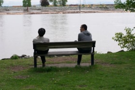
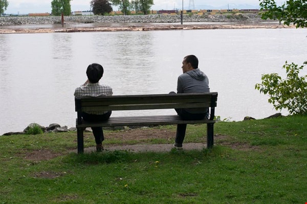
Keeping separate
https://search.heritageburnaby.ca/link/archivedescription95114
- Repository
- City of Burnaby Archives
- Date
- June 2, 2020
- Collection/Fonds
- Burnaby Photographic Society fonds
- Description Level
- Item
- Physical Description
- 1 photograph (tiff)
- Scope and Content
- Photograph of two men sitting on a bench at Fraser Foreshore Park. Photograph is taken from behind the bench, looking south over the Fraser River.
- Repository
- City of Burnaby Archives
- Date
- June 2, 2020
- Collection/Fonds
- Burnaby Photographic Society fonds
- Physical Description
- 1 photograph (tiff)
- Description Level
- Item
- Record No.
- 623-032
- Access Restriction
- No restrictions
- Reproduction Restriction
- Reproduce for fair dealing purposes only
- Accession Number
- 2020-10
- Scope and Content
- Photograph of two men sitting on a bench at Fraser Foreshore Park. Photograph is taken from behind the bench, looking south over the Fraser River.
- Subjects
- Geographic Features - Rivers
- Media Type
- Photograph
- Photographer
- Nielsen, Phil
- Notes
- Transcribed title
- Geographic Access
- Fraser River
- Historic Neighbourhood
- Fraser Arm (Historic Neighbourhood)
- Planning Study Area
- Big Bend Area
Images

Friends Distancing, Including Their Dogs
https://search.heritageburnaby.ca/link/archivedescription95115
- Repository
- City of Burnaby Archives
- Date
- June 8, 2020
- Collection/Fonds
- Burnaby Photographic Society fonds
- Description Level
- Item
- Physical Description
- 1 photograph (tiff)
- Scope and Content
- Photograph of a group of women standing on Morley Drive, near the corner of Buckingham Drive. The women are chatting at a distance from one another, and two have small dogs on leashes.
- Repository
- City of Burnaby Archives
- Date
- June 8, 2020
- Collection/Fonds
- Burnaby Photographic Society fonds
- Physical Description
- 1 photograph (tiff)
- Description Level
- Item
- Record No.
- 623-033
- Access Restriction
- No restrictions
- Reproduction Restriction
- No restrictions
- Accession Number
- 2020-10
- Scope and Content
- Photograph of a group of women standing on Morley Drive, near the corner of Buckingham Drive. The women are chatting at a distance from one another, and two have small dogs on leashes.
- Media Type
- Photograph
- Photographer
- Peterman, Randall
- Notes
- Transcribed title
- Geographic Access
- Buckingham Drive
- Morley Street
- Planning Study Area
- Morley-Buckingham Area
Images


Reconstructed Central Park Band Stand
https://search.heritageburnaby.ca/link/archivedescription95123
- Repository
- City of Burnaby Archives
- Date
- May 28, 2020
- Collection/Fonds
- Burnaby Photographic Society fonds
- Description Level
- Item
- Physical Description
- 1 photograph (tiff)
- Scope and Content
- Photograph of the band stand in Central Park. The band stand stairs are blocked off with orange netting and a City of Burnaby facility closure sign.
- Repository
- City of Burnaby Archives
- Date
- May 28, 2020
- Collection/Fonds
- Burnaby Photographic Society fonds
- Physical Description
- 1 photograph (tiff)
- Description Level
- Item
- Record No.
- 623-041
- Access Restriction
- No restrictions
- Reproduction Restriction
- No restrictions
- Accession Number
- 2020-10
- Scope and Content
- Photograph of the band stand in Central Park. The band stand stairs are blocked off with orange netting and a City of Burnaby facility closure sign.
- Subjects
- Buildings - Recreational - Bandstands
- Geographic Features - Parks
- Advertising Medium - Signs and Signboards
- Media Type
- Photograph
- Photographer
- Cheung, Ray
- Notes
- Transcribed title
- Geographic Access
- Central Park
- Imperial Street
- Street Address
- 3883 Imperial Street
- Historic Neighbourhood
- Central Park (Historic Neighbourhood)
- Planning Study Area
- Maywood Area
Images


Social Distancing
https://search.heritageburnaby.ca/link/archivedescription95128
- Repository
- City of Burnaby Archives
- Date
- April 10, 2020
- Collection/Fonds
- Burnaby Photographic Society fonds
- Description Level
- Item
- Physical Description
- 1 photograph (tiff)
- Scope and Content
- Photograph of customers lining up outside Sungiven Foods on East Hastings Street for its grand opening. Customers are standing apart from one another, spaced by red markings on the pavement. Most customers are wearing face masks and looking at their cellphones.
- Repository
- City of Burnaby Archives
- Date
- April 10, 2020
- Collection/Fonds
- Burnaby Photographic Society fonds
- Physical Description
- 1 photograph (tiff)
- Description Level
- Item
- Record No.
- 623-046
- Access Restriction
- No restrictions
- Reproduction Restriction
- Reproduce for fair dealing purposes only
- Accession Number
- 2020-10
- Scope and Content
- Photograph of customers lining up outside Sungiven Foods on East Hastings Street for its grand opening. Customers are standing apart from one another, spaced by red markings on the pavement. Most customers are wearing face masks and looking at their cellphones.
- Media Type
- Photograph
- Photographer
- Jerome, Ron
- Notes
- Transcribed title
- Geographic Access
- Hastings Street
- Street Address
- 4106 Hastings Street
- Historic Neighbourhood
- Vancouver Heights (Historic Neighbourhood)
- Planning Study Area
- Willingdon Heights Area
Images


Pandemic Litter
https://search.heritageburnaby.ca/link/archivedescription95131
- Repository
- City of Burnaby Archives
- Date
- April 30, 2020
- Collection/Fonds
- Burnaby Photographic Society fonds
- Description Level
- Item
- Physical Description
- 1 photograph (tiff)
- Scope and Content
- Photograph of two blue rubber gloves discarded on the ground of the Kensington Square Shopping Centre parking lot in North Burnaby.
- Repository
- City of Burnaby Archives
- Date
- April 30, 2020
- Collection/Fonds
- Burnaby Photographic Society fonds
- Physical Description
- 1 photograph (tiff)
- Description Level
- Item
- Record No.
- 623-049
- Access Restriction
- No restrictions
- Reproduction Restriction
- No restrictions
- Accession Number
- 2020-10
- Scope and Content
- Photograph of two blue rubber gloves discarded on the ground of the Kensington Square Shopping Centre parking lot in North Burnaby.
- Media Type
- Photograph
- Photographer
- Lapierre, Soleil
- Notes
- Transcribed title
- Geographic Access
- Hastings Street
- Street Address
- 6500 Hastings Street
- Historic Neighbourhood
- Lochdale (Historic Neighbourhood)
- Planning Study Area
- Lochdale Area
Images

Saving Burnaby Lake
https://search.heritageburnaby.ca/link/museumdescription4485
- Repository
- Burnaby Village Museum
- Date
- 2018
- Collection/Fonds
- Burnaby Village Museum fonds
- Description Level
- Item
- Physical Description
- 1 video recording (mp4) (4 min., 25 sec.) : digital, 23 fps, col., sd., stereo
- Scope and Content
- This short film was produced by the City of Burnaby Community Heritage Commission to commemorate Burnaby's 125th anniversary. It features the story of the preservation of Burnaby Lake.
- Repository
- Burnaby Village Museum
- Collection/Fonds
- Burnaby Village Museum fonds
- Description Level
- Item
- Physical Description
- 1 video recording (mp4) (4 min., 25 sec.) : digital, 23 fps, col., sd., stereo
- Scope and Content
- This short film was produced by the City of Burnaby Community Heritage Commission to commemorate Burnaby's 125th anniversary. It features the story of the preservation of Burnaby Lake.
- Publisher
- City of Burnaby
- Other Title Information
- title given by film makers
- Geographic Access
- Burnaby Lake
- Accession Code
- BV018.12.3
- Access Restriction
- No restrictions
- Reproduction Restriction
- May be restricted by third party rights
- Date
- 2018
- Media Type
- Moving Images
- Historic Neighbourhood
- Burnaby Lake (Historic Neighbourhood)
- Planning Study Area
- Burnaby Lake Area
- Notes
- Transcribed title
- Reproduction of content is restricted
Images
Video
Saving Burnaby Lake, 2018
Saving Burnaby Lake, 2018
https://search.heritageburnaby.ca/media/hpo/_Data/_BVM_Moving_Images/2018_0012_0003_001.mp4
Saving the Salmon: the Brunette River Story
https://search.heritageburnaby.ca/link/museumdescription4486
- Repository
- Burnaby Village Museum
- Date
- 2018
- Collection/Fonds
- Burnaby Village Museum fonds
- Description Level
- Item
- Physical Description
- 1 video recording (mp4) (3 min., 35 sec.) : digital, 23 fps, col., sd., stereo
- Scope and Content
- This short film was produced by the City of Burnaby Community Heritage Commission to commemorate Burnaby's 125th anniversary. It features the story of the preservation of the Brunette River.
- Repository
- Burnaby Village Museum
- Collection/Fonds
- Burnaby Village Museum fonds
- Description Level
- Item
- Physical Description
- 1 video recording (mp4) (3 min., 35 sec.) : digital, 23 fps, col., sd., stereo
- Scope and Content
- This short film was produced by the City of Burnaby Community Heritage Commission to commemorate Burnaby's 125th anniversary. It features the story of the preservation of the Brunette River.
- Publisher
- City of Burnaby
- Other Title Information
- title given by film makers
- Accession Code
- BV018.12.4
- Access Restriction
- No restrictions
- Reproduction Restriction
- May be restricted by third party rights
- Date
- 2018
- Media Type
- Moving Images
- Planning Study Area
- Burnaby Lake Area
- Notes
- Transcribed title
- Reproduction of content is restricted
Images
Video
Saving the Salmon: the Brunette River Story, 2018
Saving the Salmon: the Brunette River Story, 2018
https://search.heritageburnaby.ca/media/hpo/_Data/_BVM_Moving_Images/2018_0012_0004_001.mp4Interview with Joe Sadowski, 2017
https://search.heritageburnaby.ca/link/museumdescription5115
- Repository
- Burnaby Village Museum
- Date
- June 16, 2017
- Collection/Fonds
- Burnaby Village Museum fonds
- Description Level
- Item
- Physical Description
- 1 sound recording (mp3) (01:46.06 min)
- Scope and Content
- Recording is an interview with Joe Sadowski conducted by Burnaby Village Museum employee Rebeca Salas, June 16, 2017. Major themes discussed: the history of the Burnaby Park Advisory Association and the Group of Ten, and the ongoing conservation of Burnaby Lake. 00:00 – 3:05: Joe discusses his inv…
- Repository
- Burnaby Village Museum
- Collection/Fonds
- Burnaby Village Museum fonds
- Series
- Museum Oral Histories series
- Subseries
- Museum research interviews subseries
- Description Level
- Item
- Physical Description
- 1 sound recording (mp3) (01:46.06 min)
- Material Details
- Interviewer: Rebeca Salas Interviewee: Joe Sadowski Date of interview: June 16, 2017 Total Number of Tracks: 1 Total Length of all Tracks: 1:46:06
- Scope and Content
- Recording is an interview with Joe Sadowski conducted by Burnaby Village Museum employee Rebeca Salas, June 16, 2017. Major themes discussed: the history of the Burnaby Park Advisory Association and the Group of Ten, and the ongoing conservation of Burnaby Lake. 00:00 – 3:05: Joe discusses his involvement with the Association from its early days in the late 1960s. He describes the formation of the group, its original intentions, and its changing focus. 3:05 - 5:54: Joe recalls how the group decided to further their purpose by involving the public, and the rationale behind building a trail system. He explains how the Burnaby Outdoor Education Association was formed and describes its activities. 5:54 – 9:20: Joe relates how the Association was able to access federal funding for the trail. He shares his perspective about local businesses having changed their priorities since that time. 9:20 – 13:31: Joe discusses how the group expanded its base, and why it changed its name to the Burnaby Lake Advisory. He explains how the trail system came to be under the jurisdiction of Metro Parks, and why the name was changed to the Burnaby Lake Park Association. He describes the shift in the group’s composition and responsibilities. 13:31 – 17:06: Rebeca notes that the museum is interested in the reasons for the group coming together in the 1960s. Joe describes how the group’s plans regarding the lake informed their subsequent activities there. He talks about the changing attitude to pollution in the 1970s. 17:06 - 22:05: Joe describes what Burnaby Lake was like in the 1960s. He discusses its importance to migrating birds, and talks about the improvement to Still Creek. 22:05 – 29:48: Joe talks about the big Burnaby Lake Clean Up. He notes that the public’s changing attitudes have made further large clean-ups unnecessary. 29:48 – 32:00: Joe talks about the work of the Eagle Creek Streamkeepers, the Sapperton Fish and Game Club, The Semiahmoo Rod and Gun Club, and the Hyde Creek Watershed Society. He observes that game clubs have broader interests now than sport alone. 32:00 – 37:37: Joe discusses the return of salmon to the lake, the improvement in the quality of water, and the increased numbers of birds. He shares his perspective that the relationship of the public to the lake changed as visitors began to take ownership. 37:37 – 39:30: Joe talks about the importance of leadership in conservation efforts, discussing how Bob Gardner and Elmer Rudolph inspired people to become involved. He describes the positive results of volunteering. 39:30 – 41:48: Asked what he feels has made the biggest difference in improving the health of the lake, Joe describes the change in the attitude of the public and contrasts this new environmental awareness with that of people in other parts of the world. 41:48 – 47:46: Joe discusses the importance of the buffer zone, and of giving students the opportunity to be involved in efforts to remove invasive species and plant native ones. 47:46 – 56:10: Joe talks about the nesting box program. He notes that interacting with wildlife may influence people’s future behavior and describes the experience as cross-cultural. 56:10 – 58:17: Joe discusses the design of the trail around the lake. 58:17 – 1:02:32: Joe mentions the advisory role of Dr. Milton McLaren in the Association’s trail building work. He remarks on the importance to the project of people such as Tony Fabian and John Thomson. Joe also discusses the material used for the trail’s construction. 1:02:32 – 1:10:53: Joe describes the Association’s relationship with the Nature House and the Wildlife Rescue Centre. He recalls the acquisition of the Nature House building. 1:10:53 – 1:19:57: Asked about consultation, Joe describes the design and construction of the trail as the only subject in which the group’s expertise was deferred to. He discusses his concerns about dredging, and mentions the installation of squirrel nesting boxes as a successful enhancement project. 1:19:57 – 1:28:05: Joe talks about how the Burnaby Lake area has changed since he moved to Burnaby in 1964, and mentions some of the detrimental effects of development. He recalls the construction of the original observation tower by Aril Dalsvaag’s students at Burnaby Central Secondary School, talks about the current tower and discusses the success of the Association’s turtle nesting pad. 1:28:05 – 1:34:50: Joe discusses the introduced species in Burnaby Lake, and the efforts to eradicate them. He mentions the work of Bob Gunn, from B.C.I.T., a former student of Bob Gardner. 1:34:50 – 1:49:28: Asked about the substances used to control the mosquito population at Burnaby Lake, Joe voices his concerns about the effects of spraying, noting that the butterfly garden has been negatively affected by it in the past. He describes the origin of the garden. 1:40:28 – 1:46:06: Rebeca summarizes the interview and thanks Joe. Joe describes his hopes for the B.L.P.A. and the future of the lake. He reiterates the importance of preservation and accessibility and remarks on the number and diversity of the visitors.
- History
- Interviewee: Joe Sadowski is a founding member of the Burnaby Lake Park Association which was formerly named the Burnaby Outdoor Education Association. He has been recognized for his environmental efforts and was awarded the Community Stewardship Star in 2000 and 2004. Interviewer: Rebeca Salas is a MA student in the Department of Geography at Simon Fraser University. Rebeca is interested in the relationship between property and memory. Rebeca is an experienced researcher and oral history interviewer and has conducted several oral histories for Landscapes of Injustice Archive.
- Creator
- Burnaby Village Museum
- Subjects
- Environmental Issues
- Environmental Issues - Environmental Protection
- Geographic Features - Streams
- Geographic Features - Natural Waterways
- Geographic Features - Parks
- Responsibility
- Salas, Rebeca
- Geographic Access
- Burnaby Lake Regional Nature Park
- Burnaby Lake
- Accession Code
- BV018.18.1
- Access Restriction
- No restrictions
- Date
- June 16, 2017
- Media Type
- Sound Recording
Audio Tracks
Interview with Joe Sadowski, 2017, June 16, 2017
Interview with Joe Sadowski, 2017, June 16, 2017
https://search.heritageburnaby.ca/media/hpo/_Data/_BVM_Sound_Recordings/Oral_Histories/2018_0018_0001_001.mp3
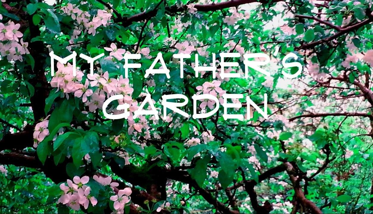
My Father's Garden
https://search.heritageburnaby.ca/link/museumdescription9676
- Repository
- Burnaby Village Museum
- Date
- 2016
- Collection/Fonds
- Burnaby Village Museum Film and Video collection
- Description Level
- Item
- Physical Description
- 1 video recording (mp4) (9 min., 26 sec.) : digital, 25 fps, col., sd., stereo
- Scope and Content
- The film tells the story of Janice Bobic’s parents, John and Frances Wuzinski, including the couple’s move from Manitoba to Burnaby in 1944, where they purchased an acre of land on the corner of Hastings Street and Cliff Avenue. They grew berries, fruit and vegetables for home and for sale, and rai…
- Repository
- Burnaby Village Museum
- Collection/Fonds
- Burnaby Village Museum Film and Video collection
- Description Level
- Item
- Physical Description
- 1 video recording (mp4) (9 min., 26 sec.) : digital, 25 fps, col., sd., stereo
- Scope and Content
- The film tells the story of Janice Bobic’s parents, John and Frances Wuzinski, including the couple’s move from Manitoba to Burnaby in 1944, where they purchased an acre of land on the corner of Hastings Street and Cliff Avenue. They grew berries, fruit and vegetables for home and for sale, and raised bees. People came from miles around to purchase strawberries, blueberries, tomatoes and honey. The film includes Janice’s memories of growing up in the family garden, along with her sister Mary Louise.Janice describes her decision to continue working the family property, and her sense of connection with her parents and the land.
- History
- Janice Bobic is the daughter of John and Frances Wuzinski, longtime Burnaby residents who moved from Manitoba to Burnaby in 1944. In 1962 the Wuzinski property was expropriated by the Municipality of Burnaby, and the family purchased another property nearby. They started a new garden, brought the bees, and transplanted several trees to the new property. John passed away in 1998, and Frances in 2000.
- Creator
- Bobic, Janice
- Other Title Information
- title supplied by film maker
- Accession Code
- BV016.37.7
- Access Restriction
- No restrictions
- Reproduction Restriction
- May be restricted by third party rights
- Date
- 2016
- Media Type
- Moving Images
- Notes
- Transcribed title
Images
Video
My Father's Garden, 2016
My Father's Garden, 2016
https://search.heritageburnaby.ca/media/hpo/_Data/_BVM_Moving_Images/2016_0037_0007_001.mp4