More like 'Interview with Elsie Ansdell by Eric Damer September 18, 2012 - Track 1'
Narrow Results By
Subject
- Advertising Medium - Signs and Signboards 2
- Animals - Dogs 1
- Buildings - Civic - Museums 3
- Buildings - Commercial 3
- Buildings - Commercial - Automobile Dealerships 1
- Buildings - Industrial 1
- Construction 1
- Construction Tools and Equipment 3
- Geographic Features - Creeks 1
- Geographic Features - Parks 11
- Geographic Features - Roads 2
- Government 7
Person / Organization
- Belhouse, Jack 2
- Bossort, Kathy 11
- Burnaby Citizen's Association 1
- Burnaby Mountain Conservation Area 9
- Burnaby Mountain Preservation Society 3
- Burnaby Planning and Building Department 1
- Burnaby School Board 1
- Burnaby Village Museum 4
- Chami, Parvin 1
- Cocke, Yvonne D. 2
- Copping, Barbara 1
- Corrigan, Derek 4
1160 Douglas Rd
https://search.heritageburnaby.ca/link/archivedescription94327
- Repository
- City of Burnaby Archives
- Date
- December 1994
- Collection/Fonds
- Grover, Elliott & Co. Ltd. fonds
- Description Level
- File
- Physical Description
- 22 photographs : col. negatives ; 35 mm
- Scope and Content
- Photographs of the exterior of a three-storey commerical building located at 1160 Douglas Road.
- Repository
- City of Burnaby Archives
- Date
- December 1994
- Collection/Fonds
- Grover, Elliott & Co. Ltd. fonds
- Physical Description
- 22 photographs : col. negatives ; 35 mm
- Description Level
- File
- Record No.
- 622-112
- Access Restriction
- No restrictions
- Reproduction Restriction
- No restrictions
- Accession Number
- 2017-39
- Scope and Content
- Photographs of the exterior of a three-storey commerical building located at 1160 Douglas Road.
- Media Type
- Photograph
- Photographer
- Young, Richard
- Notes
- Transcribed title
- Title transcribed from envelope photographs were originally housed in
- File no. 94-424-B
- Geographic Access
- Douglas Road
- Street Address
- 1160 Douglas Road
- Historic Neighbourhood
- Vancouver Heights (Historic Neighbourhood)
- Planning Study Area
- Willingdon Heights Area
4010 Regent St.
https://search.heritageburnaby.ca/link/archivedescription94318
- Repository
- City of Burnaby Archives
- Date
- September 1994
- Collection/Fonds
- Grover, Elliott & Co. Ltd. fonds
- Description Level
- File
- Physical Description
- 25 photographs : col. negatives ; 35 mm
- Scope and Content
- Photographs of an undeveloped property located at 4010 Regent Street. Property is covered with soil, brush, and some trees.
- Repository
- City of Burnaby Archives
- Date
- September 1994
- Collection/Fonds
- Grover, Elliott & Co. Ltd. fonds
- Physical Description
- 25 photographs : col. negatives ; 35 mm
- Description Level
- File
- Record No.
- 622-103
- Access Restriction
- No restrictions
- Reproduction Restriction
- No restrictions
- Accession Number
- 2017-39
- Scope and Content
- Photographs of an undeveloped property located at 4010 Regent Street. Property is covered with soil, brush, and some trees.
- Subjects
- Land Clearing
- Media Type
- Photograph
- Photographer
- Young, Richard
- Notes
- Transcribed title
- Title transcribed from envelope photographs were originally housed in
- File no. 94-342-B
- Geographic Access
- Regent Street
- Street Address
- 4010 Regent Street
- Historic Neighbourhood
- Broadview (Historic Neighbourhood)
- Planning Study Area
- West Central Valley Area
5200 Oakmount Cr.
https://search.heritageburnaby.ca/link/archivedescription94313
- Repository
- City of Burnaby Archives
- Date
- June 1994
- Collection/Fonds
- Grover, Elliott & Co. Ltd. fonds
- Description Level
- File
- Physical Description
- 23 photographs : col. negatives ; 35 mm
- Scope and Content
- Photographs of an undeveloped property located at 5200 Oakmount Crescent - an address that no longer exists.
- Repository
- City of Burnaby Archives
- Date
- June 1994
- Collection/Fonds
- Grover, Elliott & Co. Ltd. fonds
- Physical Description
- 23 photographs : col. negatives ; 35 mm
- Description Level
- File
- Record No.
- 622-098
- Access Restriction
- No restrictions
- Reproduction Restriction
- No restrictions
- Accession Number
- 2017-39
- Scope and Content
- Photographs of an undeveloped property located at 5200 Oakmount Crescent - an address that no longer exists.
- Subjects
- Land Clearing
- Media Type
- Photograph
- Notes
- Transcribed title
- Title transcribed from envelope photographs were originally housed in
- File no. 94-236-B
- Photographer identified as "J.C."
- Geographic Access
- Oakmount Crescent
- Historic Neighbourhood
- Central Park (Historic Neighbourhood)
- Planning Study Area
- Windsor Area
5548 Marshland Ave
https://search.heritageburnaby.ca/link/archivedescription94302
- Repository
- City of Burnaby Archives
- Date
- January 1994
- Collection/Fonds
- Grover, Elliott & Co. Ltd. fonds
- Description Level
- File
- Physical Description
- 25 photographs : col. negatives ; 35 mm
- Scope and Content
- Photographs of an undeveloped property located at 5548 Marshland Avenue - an address that no longer exists.
- Repository
- City of Burnaby Archives
- Date
- January 1994
- Collection/Fonds
- Grover, Elliott & Co. Ltd. fonds
- Physical Description
- 25 photographs : col. negatives ; 35 mm
- Description Level
- File
- Record No.
- 622-087
- Access Restriction
- No restrictions
- Reproduction Restriction
- No restrictions
- Accession Number
- 2017-39
- Scope and Content
- Photographs of an undeveloped property located at 5548 Marshland Avenue - an address that no longer exists.
- Subjects
- Land Clearing
- Media Type
- Photograph
- Notes
- Transcribed title
- Title transcribed from envelope photographs were originally housed in
- File no. 94-023-B
- Photographer identified as "K.D."
- Geographic Access
- Marshland Avenue
- Historic Neighbourhood
- Fraser Arm (Historic Neighbourhood)
- Planning Study Area
- Big Bend Area

6113 Silver Avenue lot
https://search.heritageburnaby.ca/link/archivedescription37775
- Repository
- City of Burnaby Archives
- Date
- 1986 (date of original), copied 1991
- Collection/Fonds
- Burnaby Historical Society fonds
- Description Level
- Item
- Physical Description
- 1 photograph : b&w ; 3.1 x 4.4 cm print on contact sheet 20.3 x 26.2 cm
- Scope and Content
- Photograph of the lot at 6113 Silver Avenue, the former home of the Ellis family. The house has been demolished and an empty lot remains. Houses, aparment buildings, and the Expo line skytrain track with cars on it can be seen in the background.
- Repository
- City of Burnaby Archives
- Date
- 1986 (date of original), copied 1991
- Collection/Fonds
- Burnaby Historical Society fonds
- Subseries
- Burnaby Image Bank subseries
- Physical Description
- 1 photograph : b&w ; 3.1 x 4.4 cm print on contact sheet 20.3 x 26.2 cm
- Description Level
- Item
- Record No.
- 370-363
- Access Restriction
- No restrictions
- Reproduction Restriction
- No restrictions
- Accession Number
- BHS1999-03
- Scope and Content
- Photograph of the lot at 6113 Silver Avenue, the former home of the Ellis family. The house has been demolished and an empty lot remains. Houses, aparment buildings, and the Expo line skytrain track with cars on it can be seen in the background.
- Subjects
- Land Clearing
- Media Type
- Photograph
- Notes
- Title based on contents of photograph
- 1 b&w copy negative accompanying
- Negative has a pink cast
- Copied from col. photograph
- Geographic Access
- Silver Avenue
- Street Address
- 6113 Silver Avenue
- Historic Neighbourhood
- Central Park (Historic Neighbourhood)
- Planning Study Area
- Maywood Area
Images

7026 Kingsway
https://search.heritageburnaby.ca/link/archivedescription94304
- Repository
- City of Burnaby Archives
- Date
- January 1994
- Collection/Fonds
- Grover, Elliott & Co. Ltd. fonds
- Description Level
- File
- Physical Description
- 19 photographs : col. negatives ; 35 mm
- Scope and Content
- Photographs of commercial and undeveloped properties located in the 7100 block of Kingsway, including Middlegate Honda, with mid-rise towers visible in the background.
- Repository
- City of Burnaby Archives
- Date
- January 1994
- Collection/Fonds
- Grover, Elliott & Co. Ltd. fonds
- Physical Description
- 19 photographs : col. negatives ; 35 mm
- Description Level
- File
- Record No.
- 622-089
- Access Restriction
- No restrictions
- Reproduction Restriction
- No restrictions
- Accession Number
- 2017-39
- Scope and Content
- Photographs of commercial and undeveloped properties located in the 7100 block of Kingsway, including Middlegate Honda, with mid-rise towers visible in the background.
- Media Type
- Photograph
- Notes
- Transcribed title
- Title transcribed from envelope photographs were originally housed in
- File no. 94-028-B
- Photographer identified as "L.D."
- Geographic Access
- Kingsway
- Historic Neighbourhood
- Edmonds (Historic Neighbourhood)
- Planning Study Area
- Stride Avenue Area
8855 Northbrook Court
https://search.heritageburnaby.ca/link/archivedescription93735
- Repository
- City of Burnaby Archives
- Date
- 1989
- Collection/Fonds
- Grover, Elliott & Co. Ltd. fonds
- Description Level
- File
- Physical Description
- 21 photographs : col. negatives ; 35 mm
- Scope and Content
- Photographs of an undeveloped property loacated at 8855 Northbrook Court. Construction equipment is visible in the distance.
- Repository
- City of Burnaby Archives
- Date
- 1989
- Collection/Fonds
- Grover, Elliott & Co. Ltd. fonds
- Physical Description
- 21 photographs : col. negatives ; 35 mm
- Description Level
- File
- Record No.
- 622-020
- Access Restriction
- No restrictions
- Reproduction Restriction
- No restrictions
- Accession Number
- 2017-39
- Scope and Content
- Photographs of an undeveloped property loacated at 8855 Northbrook Court. Construction equipment is visible in the distance.
- Media Type
- Photograph
- Notes
- Transcribed title
- Title transcribed from original print envelope
- File no. 89-037-B
- Geographic Access
- Northbrook Court
- Street Address
- 8855 Northbrook Court
- Historic Neighbourhood
- Fraser Arm (Historic Neighbourhood)
- Planning Study Area
- Big Bend Area
8980 Fraserwood Crt
https://search.heritageburnaby.ca/link/archivedescription94326
- Repository
- City of Burnaby Archives
- Date
- December 1994
- Collection/Fonds
- Grover, Elliott & Co. Ltd. fonds
- Description Level
- File
- Physical Description
- 24 photographs : col. negatives ; 35 mm
- Scope and Content
- Photographs of an undeveloped property located at 8980 Fraserwood Court. A Sutton Group real estate sign on the property advertises the site as the Fraserwood Corporate Centre with strata warehouse and office flex space. File also contains photographs of the commerical building adjacent to the si…
- Repository
- City of Burnaby Archives
- Date
- December 1994
- Collection/Fonds
- Grover, Elliott & Co. Ltd. fonds
- Physical Description
- 24 photographs : col. negatives ; 35 mm
- Description Level
- File
- Record No.
- 622-111
- Access Restriction
- No restrictions
- Reproduction Restriction
- No restrictions
- Accession Number
- 2017-39
- Scope and Content
- Photographs of an undeveloped property located at 8980 Fraserwood Court. A Sutton Group real estate sign on the property advertises the site as the Fraserwood Corporate Centre with strata warehouse and office flex space. File also contains photographs of the commerical building adjacent to the site.
- Media Type
- Photograph
- Notes
- Transcribed title
- Title transcribed from envelope photographs were originally housed in
- File no. 94-422-B
- Photographer identified as "L.D."
- Geographic Access
- Fraserwood Court
- Street Address
- 8980 Fraserwood Court
- Historic Neighbourhood
- Fraser Arm (Historic Neighbourhood)
- Planning Study Area
- Big Bend Area
Burnaby
https://search.heritageburnaby.ca/link/archivedescription93751
- Repository
- City of Burnaby Archives
- Date
- 1991
- Collection/Fonds
- Grover, Elliott & Co. Ltd. fonds
- Description Level
- File
- Physical Description
- 43 photographs : col. negatives ; 35 mm
- Scope and Content
- Photographs of the exterior of a single-storey industrial building and surrounding undeveloped property. A sign on the building reads "Bauer". The location of the building has not been identified.
- Repository
- City of Burnaby Archives
- Date
- 1991
- Collection/Fonds
- Grover, Elliott & Co. Ltd. fonds
- Physical Description
- 43 photographs : col. negatives ; 35 mm
- Description Level
- File
- Record No.
- 622-036
- Access Restriction
- No restrictions
- Reproduction Restriction
- No restrictions
- Accession Number
- 2017-39
- Scope and Content
- Photographs of the exterior of a single-storey industrial building and surrounding undeveloped property. A sign on the building reads "Bauer". The location of the building has not been identified.
- Subjects
- Buildings - Industrial
- Land Clearing
- Media Type
- Photograph
- Notes
- Transcribed title
- Title transcribed from envelope photographs were originally housed in
- File no. 91-452-B

Former site of the Kelly Douglas building
https://search.heritageburnaby.ca/link/archivedescription35027
- Repository
- City of Burnaby Archives
- Date
- August 18, 1986
- Collection/Fonds
- Burnaby Historical Society fonds
- Description Level
- Item
- Physical Description
- 1 photograph : col. ; 8.8 x 12.6 cm
- Scope and Content
- Photograph of the site of Kelly Douglas and Co. at 4700 Kingsway after the building was demolished. A bulldozer and a large truck with two men standing on it are at the back left of the photograph.
- Repository
- City of Burnaby Archives
- Date
- August 18, 1986
- Collection/Fonds
- Burnaby Historical Society fonds
- Subseries
- Evelyn Salisbury subseries
- Physical Description
- 1 photograph : col. ; 8.8 x 12.6 cm
- Material Details
- Printed on verso of photograph: "This paper manufactured by Kodak"
- Description Level
- Item
- Record No.
- 178-001
- Access Restriction
- No restrictions
- Reproduction Restriction
- Reproduce for fair dealing purposes only
- Accession Number
- BHS1986-26
- Scope and Content
- Photograph of the site of Kelly Douglas and Co. at 4700 Kingsway after the building was demolished. A bulldozer and a large truck with two men standing on it are at the back left of the photograph.
- Media Type
- Photograph
- Notes
- Title based on contents of photograph
- Geographic Access
- Kingsway
- Street Address
- 4700 Kingsway
- Historic Neighbourhood
- Central Park (Historic Neighbourhood)
- Planning Study Area
- Maywood Area
Images

Halifax / Buchanon, Bby
https://search.heritageburnaby.ca/link/archivedescription93743
- Repository
- City of Burnaby Archives
- Date
- 1989
- Collection/Fonds
- Grover, Elliott & Co. Ltd. fonds
- Description Level
- File
- Physical Description
- 25 photographs : col. negatives ; 35 mm
- Scope and Content
- Photographs of a property located between Halifax Street and Buchanon Street under construction.
- Repository
- City of Burnaby Archives
- Date
- 1989
- Collection/Fonds
- Grover, Elliott & Co. Ltd. fonds
- Physical Description
- 25 photographs : col. negatives ; 35 mm
- Description Level
- File
- Record No.
- 622-028
- Access Restriction
- No restrictions
- Reproduction Restriction
- No restrictions
- Accession Number
- 2017-39
- Scope and Content
- Photographs of a property located between Halifax Street and Buchanon Street under construction.
- Media Type
- Photograph
- Notes
- Transcribed title
- Title transcribed from print envelope photographs were originally housed in
- File no. 89-390-B
- Handwritten sticky note on print envelope reads: "BOSA - Burnaby Office". At time of description, Bosa Development's Burnaby office is located at 1300-2025 Willingdon Avenue.
- Historic Neighbourhood
- Vancouver Heights (Historic Neighbourhood)
- Planning Study Area
- Willingdon Heights Area
Lot 1 Galglardi [sic] Way
https://search.heritageburnaby.ca/link/archivedescription93746
- Repository
- City of Burnaby Archives
- Date
- 1989
- Collection/Fonds
- Grover, Elliott & Co. Ltd. fonds
- Description Level
- File
- Physical Description
- 22 photographs : col. negatives ; 35 mm
- Scope and Content
- Photographs of an undeveloped property located on Gaglardi Way and overpass.
- Repository
- City of Burnaby Archives
- Date
- 1989
- Collection/Fonds
- Grover, Elliott & Co. Ltd. fonds
- Physical Description
- 22 photographs : col. negatives ; 35 mm
- Description Level
- File
- Record No.
- 622-031
- Access Restriction
- No restrictions
- Reproduction Restriction
- No restrictions
- Accession Number
- 2017-39
- Scope and Content
- Photographs of an undeveloped property located on Gaglardi Way and overpass.
- Subjects
- Land Clearing
- Media Type
- Photograph
- Notes
- Transcribed title
- Title transcribed from print envelopes photographs were originally housed in
- File no. 89-515-B
- Geographic Access
- Gaglardi Way
Marine Way
https://search.heritageburnaby.ca/link/archivedescription93716
- Repository
- City of Burnaby Archives
- Date
- 1987
- Collection/Fonds
- Grover, Elliott & Co. Ltd. fonds
- Description Level
- File
- Physical Description
- 24 photographs : col. negatives ; 35 mm
- Scope and Content
- Photographs of an undeveloped property along Marine Way. Property is located adjacent to railway tracks and a creek.
- Repository
- City of Burnaby Archives
- Date
- 1987
- Collection/Fonds
- Grover, Elliott & Co. Ltd. fonds
- Physical Description
- 24 photographs : col. negatives ; 35 mm
- Description Level
- File
- Record No.
- 622-005
- Access Restriction
- No restrictions
- Reproduction Restriction
- No restrictions
- Accession Number
- 2017-39
- Scope and Content
- Photographs of an undeveloped property along Marine Way. Property is located adjacent to railway tracks and a creek.
- Media Type
- Photograph
- Notes
- Transcribed title
- Title transcribed from original print envelope
- File no. 87-297-B
- Geographic Access
- Marine Way
- Historic Neighbourhood
- Fraser Arm (Historic Neighbourhood)
- Planning Study Area
- Big Bend Area
North Fraser Way / Northbrook Court
https://search.heritageburnaby.ca/link/archivedescription93736
- Repository
- City of Burnaby Archives
- Date
- 1989
- Collection/Fonds
- Grover, Elliott & Co. Ltd. fonds
- Description Level
- File
- Physical Description
- 16 photographs : col. negatives ; 35 mm
- Scope and Content
- Photographs of an undeveloped property loacated at the corner of North Fraser Way and Northbrook Court.
- Repository
- City of Burnaby Archives
- Date
- 1989
- Collection/Fonds
- Grover, Elliott & Co. Ltd. fonds
- Physical Description
- 16 photographs : col. negatives ; 35 mm
- Description Level
- File
- Record No.
- 622-021
- Access Restriction
- No restrictions
- Reproduction Restriction
- No restrictions
- Accession Number
- 2017-39
- Scope and Content
- Photographs of an undeveloped property loacated at the corner of North Fraser Way and Northbrook Court.
- Subjects
- Land Clearing
- Geographic Features - Roads
- Media Type
- Photograph
- Notes
- Transcribed title
- Title transcribed from original print envelope
- File no. 89-040-B
- Geographic Access
- Northbrook Court
- North Fraser Way
- Historic Neighbourhood
- Fraser Arm (Historic Neighbourhood)
- Planning Study Area
- Big Bend Area

Residents involved in protesting tree removal
https://search.heritageburnaby.ca/link/archivedescription78595
- Repository
- City of Burnaby Archives
- Date
- October 8, 1995
- Collection/Fonds
- Burnaby NewsLeader photograph collection
- Description Level
- Item
- Physical Description
- 1 photograph : b&w ; 16.5 x 24.5 cm
- Scope and Content
- Photograph of residents of Burnaby protesting the clearing of land around the Hong Kong Bank, in Discovery Park industrial site near British Columbia Institute of Technology (BCIT).
- Repository
- City of Burnaby Archives
- Date
- October 8, 1995
- Collection/Fonds
- Burnaby NewsLeader photograph collection
- Physical Description
- 1 photograph : b&w ; 16.5 x 24.5 cm
- Description Level
- Item
- Record No.
- 535-0011
- Access Restriction
- No restrictions
- Reproduction Restriction
- No reproduction permitted
- Accession Number
- 2012-11
- Scope and Content
- Photograph of residents of Burnaby protesting the clearing of land around the Hong Kong Bank, in Discovery Park industrial site near British Columbia Institute of Technology (BCIT).
- Names
- Chami, Parvin
- Media Type
- Photograph
- Photographer
- Ponne, Simone
- Notes
- Title based on contents of photograph
- Note in black ink on recto of photograph reads: "2764A Bby Ponne / Bby p. 1 81%"
- Trim marks and/or reproduction instructions on recto (scan is cropped)
- Geographic Access
- Willingdon Avenue
- Planning Study Area
- Douglas-Gilpin Area
Images

![Inside of the surveyor's office, [198_] thumbnail](/media/hpo/_Data/_BVM_Images/2020/2020_0005_0665_001.jpg?width=280)
Inside of the surveyor's office
https://search.heritageburnaby.ca/link/museumdescription13035
- Repository
- Burnaby Village Museum
- Date
- [198_]
- Collection/Fonds
- Century Park Museum Association fonds
- Description Level
- Item
- Physical Description
- 1 photograph : col. ; 20 x 25 cm
- Scope and Content
- Photograph of the interior of the "Surveyor's Office" inside of the Heritage Village Museum. A long wood table, wood stove, roll top desk, survey plans and surveying equipment are visible.
- Repository
- Burnaby Village Museum
- Collection/Fonds
- Century Park Museum Association fonds
- Description Level
- Item
- Physical Description
- 1 photograph : col. ; 20 x 25 cm
- Scope and Content
- Photograph of the interior of the "Surveyor's Office" inside of the Heritage Village Museum. A long wood table, wood stove, roll top desk, survey plans and surveying equipment are visible.
- Names
- Burnaby Village Museum
- Accession Code
- BV020.5.665
- Access Restriction
- No restrictions
- Reproduction Restriction
- No known restrictions
- Date
- [198_]
- Media Type
- Photograph
- Related Material
- See also photograph BV020.5.664
- Scan Resolution
- 600
- Scan Date
- 1-May-20
- Scale
- 100
- Notes
- Title based on contents of photograph
Images
![Inside of the surveyor's office, [198_] thumbnail](/media/hpo/_Data/_BVM_Images/2020/2020_0005_0665_001.jpg)

Interior of land surveyor's office at Burnaby Village Museum
https://search.heritageburnaby.ca/link/museumdescription13768
- Repository
- Burnaby Village Museum
- Date
- Sept. 1987
- Collection/Fonds
- Century Park Museum Association fonds
- Description Level
- Item
- Physical Description
- 1 photograph : col. ; 9 x 12.5 cm
- Scope and Content
- Photograph of the interior of the land surveyor's office at Burnaby Village Museum. Office is furnished with a roll top desk, maps and plans and various surveying tools.
- Repository
- Burnaby Village Museum
- Collection/Fonds
- Century Park Museum Association fonds
- Description Level
- Item
- Physical Description
- 1 photograph : col. ; 9 x 12.5 cm
- Scope and Content
- Photograph of the interior of the land surveyor's office at Burnaby Village Museum. Office is furnished with a roll top desk, maps and plans and various surveying tools.
- Names
- Burnaby Village Museum
- Geographic Access
- Deer Lake Avenue
- Accession Code
- BV020.5.958
- Access Restriction
- No restrictions
- Reproduction Restriction
- No known restrictions
- Date
- Sept. 1987
- Media Type
- Photograph
- Scan Resolution
- 600
- Scan Date
- 22-Sep-2020
- Scale
- 100
- Notes
- Title based on contents of photograph
Images

Interior of real estate office at Burnaby Village Museum
https://search.heritageburnaby.ca/link/museumdescription13773
- Repository
- Burnaby Village Museum
- Date
- Sept. 1987
- Collection/Fonds
- Century Park Museum Association fonds
- Description Level
- Item
- Physical Description
- 1 photograph : col. ; 12.5 x 9 cm
- Scope and Content
- Photograph of the interior of Burnaby Village Museum realestate office.
- Repository
- Burnaby Village Museum
- Collection/Fonds
- Century Park Museum Association fonds
- Description Level
- Item
- Physical Description
- 1 photograph : col. ; 12.5 x 9 cm
- Scope and Content
- Photograph of the interior of Burnaby Village Museum realestate office.
- Names
- Burnaby Village Museum
- Geographic Access
- Deer Lake Avenue
- Accession Code
- BV020.5.963
- Access Restriction
- No restrictions
- Reproduction Restriction
- No known restrictions
- Date
- Sept. 1987
- Media Type
- Photograph
- Scan Resolution
- 600
- Scan Date
- 22-Sep-2020
- Scale
- 100
- Notes
- Title based on contents of photograph
Images

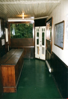
![Interior of surveyor's office, [198_] thumbnail](/media/hpo/_Data/_BVM_Images/2020/2020_0005_0838_002.jpg?width=280)
Interior of surveyor's office
https://search.heritageburnaby.ca/link/museumdescription13495
- Repository
- Burnaby Village Museum
- Date
- [198_]
- Collection/Fonds
- Century Park Museum Association fonds
- Description Level
- Item
- Physical Description
- 1 photograph : col. negative ; 5.5 x 5.5 cm
- Scope and Content
- Photograph of the interior of the Land Surveyor's office "Hill & Burnett" inside of Burnaby Village Museum. The exhibit includes a roll top desk, a pendulum wall clock as well as land surveying equipment.
- Repository
- Burnaby Village Museum
- Collection/Fonds
- Century Park Museum Association fonds
- Description Level
- Item
- Physical Description
- 1 photograph : col. negative ; 5.5 x 5.5 cm
- Scope and Content
- Photograph of the interior of the Land Surveyor's office "Hill & Burnett" inside of Burnaby Village Museum. The exhibit includes a roll top desk, a pendulum wall clock as well as land surveying equipment.
- Subjects
- Occupations - Land Surveyors
- Surveying and Navigational Tools and Equipment
- Timekeeping Tools and Equipment
- Names
- Burnaby Village Museum
- Accession Code
- BV020.5.838
- Access Restriction
- No restrictions
- Reproduction Restriction
- No known restrictions
- Date
- [198_]
- Media Type
- Photograph
- Scan Resolution
- 1200
- Scan Date
- 25-Aug-2020
- Scale
- 100
- Notes
- Title based on contents of photograph
- 1 col. print; 8.5 x 9 cm accompanying negative (negative no.4)
Images
![Interior of surveyor's office, [198_] thumbnail](/media/hpo/_Data/_BVM_Images/2020/2020_0005_0838_002.jpg)
Interview with Alekxos Sarter by Kathy Bossort October 16, 2015 - Track 7
https://search.heritageburnaby.ca/link/oralhistory583
- Repository
- City of Burnaby Archives
- Date Range
- 1963-2015
- Length
- 0:13:39
- Summary
- This portion of the interview is about Alekxos Sarter’s views on the origin and subsequent development and resolution of the dispute between SFU and the City of Burnaby over land ownership and land use on Burnaby Mountain.
- Repository
- City of Burnaby Archives
- Summary
- This portion of the interview is about Alekxos Sarter’s views on the origin and subsequent development and resolution of the dispute between SFU and the City of Burnaby over land ownership and land use on Burnaby Mountain.
- Date Range
- 1963-2015
- Length
- 0:13:39
- Subjects
- Geographic Features - Parks
- Government
- Land
- Geographic Access
- Burnaby Mountain Conservation Area
- Interviewer
- Bossort, Kathy
- Interview Date
- October 16, 2015
- Scope and Content
- Recording is of an interview with Alekxos Sarter conducted by Kathy Bossort. Alekxos Sarter was one of 23 participants interviewed as part of the Community Heritage Commission’s Burnaby Mountain Oral History Project. The interview is mainly about the history of setting aside parkland on Burnaby Mountain from Alekxos Sarter’s perspective and experience as employee in the City of Burnaby Parks, Recreation and Cultural Services. The interview provides an excellent explanation of the history and function of kinds of park dedications used by the City of Burnaby; an overview of issues around including the Trans Mountain tank farm in the conservation area; and the background to the land use and ownership disagreement between the City of Burnaby and Simon Fraser University, its resolution, and the subsequent development of SFU’s UniverCity. Alekxos Sarter talks about Richard Bolton, Burnaby’s Acting-Commissioner who was responsible for dedicating the first park on Burnaby Mountain in 1942, and the creation of a park named after him in UniverCity.
- Biographical Notes
- Alekxos Sarter was born in Vancouver in 1961, to Daine and Kasandra Sarter. She grew up in North Vancouver and since 1994 has lived on a sailboat in False Creek. After attending UBC where she studied landscape architecture, she was hired by the City of Burnaby Parks, Recreation and Cultural Services in 1986. Working first in parks design, Alekxos quickly moved into parks planning, her preferred career. As Research Officer she covers research, planning, public consultation, parks and facility inventory, parkland acquisition, among other duties.
- Total Tracks
- 9
- Total Length
- 2:20:47
- Interviewee Name
- Sarter, Alekxos T.
- Interview Location
- City of Burnaby Parks, Recreation and Cultural Services meeting room
- Interviewer Bio
- Kathy Bossort is a retired archivist living in Ladner, BC. She worked at the Delta Museum and Archives after graduating from SLAIS (UBC) in 2001 with Masters degrees in library science and archival studies. Kathy grew up in Calgary, Alberta, and, prior to this career change, she lived in the West Kootenays, earning her living as a cook for BC tourist lodges and work camps. She continues to be interested in oral histories as a way to fill the gaps in the written record and bring richer meaning to history.
- Collection/Fonds
- Community Heritage Commission Special Projects fonds
- Media Type
- Sound Recording
Audio Tracks
Track seven of interview with Alekxos Sarter
Track seven of interview with Alekxos Sarter
https://search.heritageburnaby.ca/media/hpo/_Data/_Archives_Oral_Histories/_Unrestricted/MSS196-005/MSS196-005_Track_7.mp3