More like 'Alfred Bingham's writings - Track 7'
Narrow Results By
Subject
- Buildings - Civic - Museums 6
- Buildings - Residential - Cabins 1
- Buildings - Residential - Houses 1
- Businesses - Real Estate Agencies 3
- Construction Tools and Equipment 6
- Documentary Artifacts - Architectural Drawings 2
- Geographic Features - Roads 3
- Government - Local Government 2
- Industries - Forestry 1
- Industries - Logging/lumber 1
- Land Clearing 17
- Land - Land Surveying 4

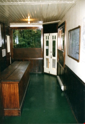
Interior of land surveyor's office at Burnaby Village Museum
https://search.heritageburnaby.ca/link/museumdescription13768
- Repository
- Burnaby Village Museum
- Date
- Sept. 1987
- Collection/Fonds
- Century Park Museum Association fonds
- Description Level
- Item
- Physical Description
- 1 photograph : col. ; 9 x 12.5 cm
- Scope and Content
- Photograph of the interior of the land surveyor's office at Burnaby Village Museum. Office is furnished with a roll top desk, maps and plans and various surveying tools.
- Repository
- Burnaby Village Museum
- Collection/Fonds
- Century Park Museum Association fonds
- Description Level
- Item
- Physical Description
- 1 photograph : col. ; 9 x 12.5 cm
- Scope and Content
- Photograph of the interior of the land surveyor's office at Burnaby Village Museum. Office is furnished with a roll top desk, maps and plans and various surveying tools.
- Names
- Burnaby Village Museum
- Geographic Access
- Deer Lake Avenue
- Accession Code
- BV020.5.958
- Access Restriction
- No restrictions
- Reproduction Restriction
- No known restrictions
- Date
- Sept. 1987
- Media Type
- Photograph
- Scan Resolution
- 600
- Scan Date
- 22-Sep-2020
- Scale
- 100
- Notes
- Title based on contents of photograph
Images

Interior of real estate office at Burnaby Village Museum
https://search.heritageburnaby.ca/link/museumdescription13773
- Repository
- Burnaby Village Museum
- Date
- Sept. 1987
- Collection/Fonds
- Century Park Museum Association fonds
- Description Level
- Item
- Physical Description
- 1 photograph : col. ; 12.5 x 9 cm
- Scope and Content
- Photograph of the interior of Burnaby Village Museum realestate office.
- Repository
- Burnaby Village Museum
- Collection/Fonds
- Century Park Museum Association fonds
- Description Level
- Item
- Physical Description
- 1 photograph : col. ; 12.5 x 9 cm
- Scope and Content
- Photograph of the interior of Burnaby Village Museum realestate office.
- Names
- Burnaby Village Museum
- Geographic Access
- Deer Lake Avenue
- Accession Code
- BV020.5.963
- Access Restriction
- No restrictions
- Reproduction Restriction
- No known restrictions
- Date
- Sept. 1987
- Media Type
- Photograph
- Scan Resolution
- 600
- Scan Date
- 22-Sep-2020
- Scale
- 100
- Notes
- Title based on contents of photograph
Images

![Inside of the surveyor's office, [198_] thumbnail](/media/hpo/_Data/_BVM_Images/2020/2020_0005_0665_001.jpg?width=280)
Inside of the surveyor's office
https://search.heritageburnaby.ca/link/museumdescription13035
- Repository
- Burnaby Village Museum
- Date
- [198_]
- Collection/Fonds
- Century Park Museum Association fonds
- Description Level
- Item
- Physical Description
- 1 photograph : col. ; 20 x 25 cm
- Scope and Content
- Photograph of the interior of the "Surveyor's Office" inside of the Heritage Village Museum. A long wood table, wood stove, roll top desk, survey plans and surveying equipment are visible.
- Repository
- Burnaby Village Museum
- Collection/Fonds
- Century Park Museum Association fonds
- Description Level
- Item
- Physical Description
- 1 photograph : col. ; 20 x 25 cm
- Scope and Content
- Photograph of the interior of the "Surveyor's Office" inside of the Heritage Village Museum. A long wood table, wood stove, roll top desk, survey plans and surveying equipment are visible.
- Names
- Burnaby Village Museum
- Accession Code
- BV020.5.665
- Access Restriction
- No restrictions
- Reproduction Restriction
- No known restrictions
- Date
- [198_]
- Media Type
- Photograph
- Related Material
- See also photograph BV020.5.664
- Scan Resolution
- 600
- Scan Date
- 1-May-20
- Scale
- 100
- Notes
- Title based on contents of photograph
Images
![Inside of the surveyor's office, [198_] thumbnail](/media/hpo/_Data/_BVM_Images/2020/2020_0005_0665_001.jpg)
![Interior of surveyor's office, [198_] thumbnail](/media/hpo/_Data/_BVM_Images/2020/2020_0005_0838_002.jpg?width=280)
Interior of surveyor's office
https://search.heritageburnaby.ca/link/museumdescription13495
- Repository
- Burnaby Village Museum
- Date
- [198_]
- Collection/Fonds
- Century Park Museum Association fonds
- Description Level
- Item
- Physical Description
- 1 photograph : col. negative ; 5.5 x 5.5 cm
- Scope and Content
- Photograph of the interior of the Land Surveyor's office "Hill & Burnett" inside of Burnaby Village Museum. The exhibit includes a roll top desk, a pendulum wall clock as well as land surveying equipment.
- Repository
- Burnaby Village Museum
- Collection/Fonds
- Century Park Museum Association fonds
- Description Level
- Item
- Physical Description
- 1 photograph : col. negative ; 5.5 x 5.5 cm
- Scope and Content
- Photograph of the interior of the Land Surveyor's office "Hill & Burnett" inside of Burnaby Village Museum. The exhibit includes a roll top desk, a pendulum wall clock as well as land surveying equipment.
- Subjects
- Occupations - Land Surveyors
- Surveying and Navigational Tools and Equipment
- Timekeeping Tools and Equipment
- Names
- Burnaby Village Museum
- Accession Code
- BV020.5.838
- Access Restriction
- No restrictions
- Reproduction Restriction
- No known restrictions
- Date
- [198_]
- Media Type
- Photograph
- Scan Resolution
- 1200
- Scan Date
- 25-Aug-2020
- Scale
- 100
- Notes
- Title based on contents of photograph
- 1 col. print; 8.5 x 9 cm accompanying negative (negative no.4)
Images
![Interior of surveyor's office, [198_] thumbnail](/media/hpo/_Data/_BVM_Images/2020/2020_0005_0838_002.jpg)
![Real Estate - Surveyor's office building, [1977] thumbnail](/media/hpo/_Data/_BVM_Images/2020/2020_0005_1509_001.jpg?width=280)
Real Estate - Surveyor's office building
https://search.heritageburnaby.ca/link/museumdescription14680
- Repository
- Burnaby Village Museum
- Date
- [1977]
- Collection/Fonds
- Century Park Museum Association fonds
- Description Level
- Item
- Physical Description
- 1 photograph : col. slide ; 35 mm
- Scope and Content
- Photograph of the Real Estate Office and Surveyor's building being moved and installed on the southeast end of Hill Street inside of Heritage Village. The building is elevated on wood cribbing piles prior to being lowered over he foundation area. The Royal Bank building is visible to the right.
- Repository
- Burnaby Village Museum
- Collection/Fonds
- Century Park Museum Association fonds
- Description Level
- Item
- Physical Description
- 1 photograph : col. slide ; 35 mm
- Scope and Content
- Photograph of the Real Estate Office and Surveyor's building being moved and installed on the southeast end of Hill Street inside of Heritage Village. The building is elevated on wood cribbing piles prior to being lowered over he foundation area. The Royal Bank building is visible to the right.
- History
- The building was originally located at 3043 (pre-1958) / 6108 Patterson Avenue, Lot 22, Block 33, District Lot 151, Plan 2002. It was built ca. 1929, possibly by Mr. Cuthbert Pratt. Over the years it was used as a confectionary store, grocery store, home, and small boarding house. By 1977, it was operating as the Magee Grocery Store. The building was moved to BVM in May 1977 and then adapted to look like the original Dow, Fraser & Co. Ltd. real estate building.
- Names
- Burnaby Village Museum
- Accession Code
- BV020.5.1509
- Access Restriction
- No restrictions
- Reproduction Restriction
- No known restrictions
- Date
- [1977]
- Media Type
- Photograph
- Scan Resolution
- 2400
- Scan Date
- 17-Nov-2020
- Scale
- 100
- Notes
- Title based on contents of photograph
Images
![Real Estate - Surveyor's office building, [1977] thumbnail](/media/hpo/_Data/_BVM_Images/2020/2020_0005_1509_001.jpg)
![Real Estate - Surveyor's office building, [1977] thumbnail](/media/hpo/_Data/_BVM_Images/2020/2020_0005_1512_001.jpg?width=280)
Real Estate - Surveyor's office building
https://search.heritageburnaby.ca/link/museumdescription14684
- Repository
- Burnaby Village Museum
- Date
- [1977]
- Collection/Fonds
- Century Park Museum Association fonds
- Description Level
- Item
- Physical Description
- 1 photograph : col. slide ; 35 mm
- Scope and Content
- Photograph of the Real Estate Office and Surveyor's building on the southeast end of Hill Street inside of Heritage Village. Exterior signage above the door and window reads: "BRANCH / DOW, FRASER & CO LIMITED / (A TRUST COMPANY) / REAL ESTATE_LOANS_FIRE INSURANCE" ; "REAL ESTATE".
- Repository
- Burnaby Village Museum
- Collection/Fonds
- Century Park Museum Association fonds
- Description Level
- Item
- Physical Description
- 1 photograph : col. slide ; 35 mm
- Scope and Content
- Photograph of the Real Estate Office and Surveyor's building on the southeast end of Hill Street inside of Heritage Village. Exterior signage above the door and window reads: "BRANCH / DOW, FRASER & CO LIMITED / (A TRUST COMPANY) / REAL ESTATE_LOANS_FIRE INSURANCE" ; "REAL ESTATE".
- History
- The building was originally located at 3043 (pre-1958) / 6108 Patterson Avenue, Lot 22, Block 33, District Lot 151, Plan 2002. It was built ca. 1929, possibly by Mr. Cuthbert Pratt. Over the years it was used as a confectionary store, grocery store, home, and small boarding house. By 1977, it was operating as the Magee Grocery Store. The building was moved to BVM in May 1977 and then adapted to look like the original Dow, Fraser & Co. Ltd. real estate building.
- Names
- Burnaby Village Museum
- Accession Code
- BV020.5.1512
- Access Restriction
- No restrictions
- Reproduction Restriction
- No known restrictions
- Date
- [1977]
- Media Type
- Photograph
- Scan Resolution
- 2400
- Scan Date
- 17-Nov-2020
- Scale
- 100
- Notes
- Title based on contents of photograph
Images
![Real Estate - Surveyor's office building, [1977] thumbnail](/media/hpo/_Data/_BVM_Images/2020/2020_0005_1512_001.jpg)
![Real Estate - Surveyor's office building, [1977] thumbnail](/media/hpo/_Data/_BVM_Images/2020/2020_0005_1515_001.jpg?width=280)
Real Estate - Surveyor's office building
https://search.heritageburnaby.ca/link/museumdescription14687
- Repository
- Burnaby Village Museum
- Date
- [1977]
- Collection/Fonds
- Century Park Museum Association fonds
- Description Level
- Item
- Physical Description
- 1 photograph : col. slide ; 35 mm
- Scope and Content
- Photograph of the south side of Real Estate Office and Surveyor's building newly installed at the southeast corner of Hill Street inside of Heritage Village. Two large picture windows and entrance door to the Hill & Burnett Surveyor's office have been installed.
- Repository
- Burnaby Village Museum
- Collection/Fonds
- Century Park Museum Association fonds
- Description Level
- Item
- Physical Description
- 1 photograph : col. slide ; 35 mm
- Scope and Content
- Photograph of the south side of Real Estate Office and Surveyor's building newly installed at the southeast corner of Hill Street inside of Heritage Village. Two large picture windows and entrance door to the Hill & Burnett Surveyor's office have been installed.
- History
- The building was originally located at 3043 (pre-1958) / 6108 Patterson Avenue, Lot 22, Block 33, District Lot 151, Plan 2002. It was built ca. 1929, possibly by Mr. Cuthbert Pratt. Over the years it was used as a confectionary store, grocery store, home, and small boarding house. By 1977, it was operating as the Magee Grocery Store. The building was moved to BVM in May 1977 and then adapted to look like the original Dow, Fraser & Co. Ltd. real estate building.
- Names
- Burnaby Village Museum
- Accession Code
- BV020.5.1515
- Access Restriction
- No restrictions
- Reproduction Restriction
- No known restrictions
- Date
- [1977]
- Media Type
- Photograph
- Scan Resolution
- 2400
- Scan Date
- 17-Nov-2020
- Scale
- 100
- Notes
- Title based on contents of photograph
Images
![Real Estate - Surveyor's office building, [1977] thumbnail](/media/hpo/_Data/_BVM_Images/2020/2020_0005_1515_001.jpg)

Burnaby property tax assessment ledger no date - pre 1898
https://search.heritageburnaby.ca/link/museumlibrary1118
- Repository
- Burnaby Village Museum
- Collection
- Reference Collection
- Material Type
- Textual Record
- Call Number
- 971.1 BUR
- Author
- J.D.B.
- Place of Publication
- Burnaby
- Publication Date
- 1977
- Physical Description
- 96 p. (typewritten) + title page
- Library Subject (LOC)
- Land titles
- Subjects
- Land - Land Surveying
- Taxes
- Object History
- Compiled July-August 1977, Heritage Village Archives
- Notes
- Unpublished research document: "Burnaby Property Tax Assessment Ledger / No Date --- Pre 1898 / Compiled July-August 1977 / Heritage Village Archives / Original Document No. / Copy #1 / J.D.B./77" -- title page
Images

Documents
![Surveying for the construction of a log cabin, [1976] thumbnail](/media/hpo/_Data/_BVM_Images/2020/2020_0005_0888_001.jpg?width=280)
Surveying for the construction of a log cabin
https://search.heritageburnaby.ca/link/museumdescription13696
- Repository
- Burnaby Village Museum
- Date
- [1976]
- Collection/Fonds
- Century Park Museum Association fonds
- Description Level
- Item
- Physical Description
- 1 photograph : col. slide ; 35 mm
- Scope and Content
- Photograph of a group of men surveying for the construction of a log cabin. The man in the centre of the photogaph is using a level. In the summer of 1976, Heritage Village Museum offered a two day log cabin building course under the expert instruction of Earl Carter.
- Repository
- Burnaby Village Museum
- Collection/Fonds
- Century Park Museum Association fonds
- Description Level
- Item
- Physical Description
- 1 photograph : col. slide ; 35 mm
- Scope and Content
- Photograph of a group of men surveying for the construction of a log cabin. The man in the centre of the photogaph is using a level. In the summer of 1976, Heritage Village Museum offered a two day log cabin building course under the expert instruction of Earl Carter.
- Accession Code
- BV020.5.888
- Access Restriction
- No restrictions
- Reproduction Restriction
- No known restrictions
- Date
- [1976]
- Media Type
- Photograph
- Scan Resolution
- 2400
- Scan Date
- September 1, 2020
- Scale
- 100
- Notes
- Title based on contents of photograph
- See also BV020.5.709 for documentary film titled "Cabin" directed and produced by James (Jim) Bizzochi - documenting the construction of the log cabin in Heritage Village
Images
![Surveying for the construction of a log cabin, [1976] thumbnail](/media/hpo/_Data/_BVM_Images/2020/2020_0005_0888_001.jpg)
![Surveyor at Heritage Village, [1971] thumbnail](/media/hpo/_Data/_BVM_Images/2005/2005_0054_0431_001.jpg?width=280)
Surveyor at Heritage Village
https://search.heritageburnaby.ca/link/museumdescription2385
- Repository
- Burnaby Village Museum
- Date
- [1971]
- Collection/Fonds
- Donald Copan collection
- Description Level
- Item
- Physical Description
- 1 photograph : b&w ; 8.9 x 12.7 cm
- Scope and Content
- Photograph of an unidentified man using surveying equipment on Heritage Village site (now Burnaby Village Museum).
- Repository
- Burnaby Village Museum
- Collection/Fonds
- Donald Copan collection
- Series
- Copan album series
- Description Level
- Item
- Physical Description
- 1 photograph : b&w ; 8.9 x 12.7 cm
- Scope and Content
- Photograph of an unidentified man using surveying equipment on Heritage Village site (now Burnaby Village Museum).
- Subjects
- Occupations - Land Surveyors
- Names
- Burnaby Village Museum
- Accession Code
- BV005.54.431
- Access Restriction
- No restrictions
- Reproduction Restriction
- May be restricted by third party rights
- Date
- [1971]
- Media Type
- Photograph
- Historic Neighbourhood
- Burnaby Lake (Historic Neighbourhood)
- Planning Study Area
- Morley-Buckingham Area
- Scan Resolution
- 600
- Scan Date
- August 11, 2020
- Scale
- 100
- Notes
- Title based on contents of photograph
Images
![Surveyor at Heritage Village, [1971] thumbnail](/media/hpo/_Data/_BVM_Images/2005/2005_0054_0431_001.jpg)
![Surveyor at Heritage Village, [1971] thumbnail](/media/hpo/_Data/_BVM_Images/2005/2005_0054_0432_001.jpg?width=280)
Surveyor at Heritage Village
https://search.heritageburnaby.ca/link/museumdescription13557
- Repository
- Burnaby Village Museum
- Date
- [1971]
- Collection/Fonds
- Donald Copan collection
- Description Level
- Item
- Physical Description
- 1 photograph : b&w ; 8.9 x 12.7 cm
- Scope and Content
- Photograph of an unidentified man using surveying equipment on Heritage Village site (now Burnaby Village Museum).
- Repository
- Burnaby Village Museum
- Collection/Fonds
- Donald Copan collection
- Series
- Copan album series
- Description Level
- Item
- Physical Description
- 1 photograph : b&w ; 8.9 x 12.7 cm
- Scope and Content
- Photograph of an unidentified man using surveying equipment on Heritage Village site (now Burnaby Village Museum).
- Subjects
- Occupations - Land Surveyors
- Names
- Burnaby Village Museum
- Accession Code
- BV005.54.432
- Access Restriction
- No restrictions
- Reproduction Restriction
- May be restricted by third party rights
- Date
- [1971]
- Media Type
- Photograph
- Historic Neighbourhood
- Burnaby Lake (Historic Neighbourhood)
- Planning Study Area
- Morley-Buckingham Area
- Scan Resolution
- 600
- Scan Date
- August 11, 2020
- Scale
- 100
- Notes
- Title based on contents of photograph
Images
![Surveyor at Heritage Village, [1971] thumbnail](/media/hpo/_Data/_BVM_Images/2005/2005_0054_0432_001.jpg)
![Cleared lot, [1948] thumbnail](/media/hpo/_Data/_BVM_Images/1971/197100120085.jpg?width=280)
Cleared lot
https://search.heritageburnaby.ca/link/museumdescription17
- Repository
- Burnaby Village Museum
- Date
- [1948]
- Collection/Fonds
- Burnaby Village Museum Photograph collection
- Description Level
- Item
- Physical Description
- 1 photograph : b&w ; 6.8 x 11.3 cm
- Scope and Content
- Photograph of a large cleared lot with two houses built apart from each other. Catalogue information from 1976 indicates that the photograph depicts the development of one of Burnaby's streets, ca. 1948. This may be the site of the Willingdon Heights subdivision. Stamped on back of photo: "657X."
- Repository
- Burnaby Village Museum
- Collection/Fonds
- Burnaby Village Museum Photograph collection
- Description Level
- Item
- Physical Description
- 1 photograph : b&w ; 6.8 x 11.3 cm
- Scope and Content
- Photograph of a large cleared lot with two houses built apart from each other. Catalogue information from 1976 indicates that the photograph depicts the development of one of Burnaby's streets, ca. 1948. This may be the site of the Willingdon Heights subdivision. Stamped on back of photo: "657X."
- Subjects
- Land Clearing
- Names
- Bingham, Alfred "Alf"
- Accession Code
- HV971.12.85
- Access Restriction
- No restrictions
- Reproduction Restriction
- No known restrictions
- Date
- [1948]
- Media Type
- Photograph
- Historic Neighbourhood
- Vancouver Heights (Historic Neighbourhood)
- Planning Study Area
- Willingdon Heights Area
- Scan Resolution
- 600
- Scan Date
- 2023-03-21
- Notes
- Title based on contents of photograph
Images
![Cleared lot, [1948] thumbnail](/media/hpo/_Data/_BVM_Images/1971/197100120085.jpg)
![Paved road, [1948] thumbnail](/media/hpo/_Data/_BVM_Images/1971/1971_0012_0087_001.jpg?width=280)
Paved road
https://search.heritageburnaby.ca/link/museumdescription19
- Repository
- Burnaby Village Museum
- Date
- [1948]
- Collection/Fonds
- Burnaby Village Museum Photograph collection
- Description Level
- Item
- Physical Description
- 1 photograph : sepia ; 6.8 x 11.4 cm
- Scope and Content
- Photograph of a paved road running through a cleared lot. There is an electric post on the roadside, and woods in the background. Catalogue information from 1976 indicates that it is a street development in Burnaby, ca. 1948. This may be the site of the Willingdon Heights subdivision. Annotation o…
- Repository
- Burnaby Village Museum
- Collection/Fonds
- Burnaby Village Museum Photograph collection
- Description Level
- Item
- Physical Description
- 1 photograph : sepia ; 6.8 x 11.4 cm
- Scope and Content
- Photograph of a paved road running through a cleared lot. There is an electric post on the roadside, and woods in the background. Catalogue information from 1976 indicates that it is a street development in Burnaby, ca. 1948. This may be the site of the Willingdon Heights subdivision. Annotation on lower right front of photograph: "26." Stamped on back of photograph: "321X."
- Subjects
- Geographic Features - Roads
- Land Clearing
- Names
- Bingham, Alfred "Alf"
- Accession Code
- HV971.12.87
- Access Restriction
- No restrictions
- Reproduction Restriction
- No known restrictions
- Date
- [1948]
- Media Type
- Photograph
- Historic Neighbourhood
- Vancouver Heights (Historic Neighbourhood)
- Planning Study Area
- Willingdon Heights Area
- Scan Resolution
- 600
- Scan Date
- 2023-03-21
- Notes
- Title based on contents of photograph
Images
![Paved road, [1948] thumbnail](/media/hpo/_Data/_BVM_Images/1971/1971_0012_0087_001.jpg)
![Ada Bingham by a tree stump, [1948] thumbnail](/media/hpo/_Data/_BVM_Images/1976/1976_0046_0005_001.jpg?width=280)
Ada Bingham by a tree stump
https://search.heritageburnaby.ca/link/museumdescription739
- Repository
- Burnaby Village Museum
- Date
- [1948]
- Collection/Fonds
- Burnaby Village Museum Photograph collection
- Description Level
- Item
- Physical Description
- 1 photograph : b&w ; 11.3 x 6.8 cm
- Scope and Content
- Photograph of Mary Ada Bingham standing in front of a giant tree stump in Willingdon Heights which was to be cleared for a veterans' housing project in 1948. According to an accompanying note prepared by Burnaby Village Museum, and supported by the inscription on the photograph, Ada Bingham came to…
- Repository
- Burnaby Village Museum
- Collection/Fonds
- Burnaby Village Museum Photograph collection
- Description Level
- Item
- Physical Description
- 1 photograph : b&w ; 11.3 x 6.8 cm
- Material Details
- Inscribed in black ballpoint pen, on the back of the photo: "Ada and Big Stump / Clearing time on Willingdon Heights / 1948. / Burnaby 2. B. C" and in blue ballpoint pen: "Mrs. Mary Ada Bingham / 1 Real Pioneer Wife; she helped me clear the land. Build our home, dig out well and worked for the community for nearly 50 years. She died August 9, 1969 / Alf Bingham."
- Scope and Content
- Photograph of Mary Ada Bingham standing in front of a giant tree stump in Willingdon Heights which was to be cleared for a veterans' housing project in 1948. According to an accompanying note prepared by Burnaby Village Museum, and supported by the inscription on the photograph, Ada Bingham came to Burnaby to homestead with her husband, Alfred "Alf" Bingham, in 1919. They settled in the Lochdale district of North Burnaby but later moved to Parker Street.
- Subjects
- Land Clearing
- Plants - Trees
- Names
- Bingham, Mary Ada "Ada"
- Accession Code
- HV976.46.5
- Access Restriction
- No restrictions
- Reproduction Restriction
- No known restrictions
- Date
- [1948]
- Media Type
- Photograph
- Historic Neighbourhood
- Vancouver Heights (Historic Neighbourhood)
- Planning Study Area
- Willingdon Heights Area
- Scan Resolution
- 600
- Scan Date
- 2023-06-20
- Notes
- Title based on contents of photograph
Images
![Ada Bingham by a tree stump, [1948] thumbnail](/media/hpo/_Data/_BVM_Images/1976/1976_0046_0005_001.jpg)
![Man on a bulldozer, [194-] thumbnail](/media/hpo/_Data/_BVM_Images/1971/197100120077.jpg?width=280)
Man on a bulldozer
https://search.heritageburnaby.ca/link/museumdescription9
- Repository
- Burnaby Village Museum
- Date
- [194-]
- Collection/Fonds
- Burnaby Village Museum Photograph collection
- Description Level
- Item
- Physical Description
- 1 photograph : b&w ; 6.9 x 11.4 cm
- Scope and Content
- Photograph of an unidentified man, possibly the operator, is standing on a bulldozer belonging to "Holmes & Wilson Trucking". Lumber stacks are nearby, and the bulldozer is on a clearing for a house lot. This may be related to the construction of the Willingdon Heights subdivision. Stamped on bac…
- Repository
- Burnaby Village Museum
- Collection/Fonds
- Burnaby Village Museum Photograph collection
- Description Level
- Item
- Physical Description
- 1 photograph : b&w ; 6.9 x 11.4 cm
- Scope and Content
- Photograph of an unidentified man, possibly the operator, is standing on a bulldozer belonging to "Holmes & Wilson Trucking". Lumber stacks are nearby, and the bulldozer is on a clearing for a house lot. This may be related to the construction of the Willingdon Heights subdivision. Stamped on back of photo: "342X."
- Names
- Bingham, Alfred "Alf"
- Accession Code
- HV971.12.77
- Access Restriction
- No restrictions
- Reproduction Restriction
- No known restrictions
- Date
- [194-]
- Media Type
- Photograph
- Historic Neighbourhood
- Vancouver Heights (Historic Neighbourhood)
- Planning Study Area
- Willingdon Heights Area
- Scan Resolution
- 600
- Scan Date
- 2023-03-21
- Notes
- Title based on contents of photograph
Images
![Man on a bulldozer, [194-] thumbnail](/media/hpo/_Data/_BVM_Images/1971/197100120077.jpg)
![Man on a bulldozer, [194-] thumbnail](/media/hpo/_Data/_BVM_Images/1971/197100120078.jpg?width=280)
Man on a bulldozer
https://search.heritageburnaby.ca/link/museumdescription10
- Repository
- Burnaby Village Museum
- Date
- [194-]
- Collection/Fonds
- Burnaby Village Museum Photograph collection
- Description Level
- Item
- Physical Description
- 1 photograph : b&w ; 6.9 x 11.9 cm
- Scope and Content
- Photograph of an unidentified man standing on a bulldozer belonging to "Wm. Edstrom" as written on the machine. The bulldozer is on a clearing nearby houses. This may be related to the construction of the Willingdon Heights subdivision. Stamped on back of the photograph: "342X."
- Repository
- Burnaby Village Museum
- Collection/Fonds
- Burnaby Village Museum Photograph collection
- Description Level
- Item
- Physical Description
- 1 photograph : b&w ; 6.9 x 11.9 cm
- Scope and Content
- Photograph of an unidentified man standing on a bulldozer belonging to "Wm. Edstrom" as written on the machine. The bulldozer is on a clearing nearby houses. This may be related to the construction of the Willingdon Heights subdivision. Stamped on back of the photograph: "342X."
- Names
- Bingham, Alfred "Alf"
- Accession Code
- HV971.12.78
- Access Restriction
- No restrictions
- Reproduction Restriction
- No known restrictions
- Date
- [194-]
- Media Type
- Photograph
- Historic Neighbourhood
- Vancouver Heights (Historic Neighbourhood)
- Planning Study Area
- Willingdon Heights Area
- Scan Resolution
- 600
- Scan Date
- 2023-03-21
- Notes
- Title based on contents of photograph
Images
![Man on a bulldozer, [194-] thumbnail](/media/hpo/_Data/_BVM_Images/1971/197100120078.jpg)
![Bulldozer clearing a Forested Hill, [194-] thumbnail](/media/hpo/_Data/_BVM_Images/1971/197100120079.jpg?width=280)
Bulldozer clearing a Forested Hill
https://search.heritageburnaby.ca/link/museumdescription11
- Repository
- Burnaby Village Museum
- Date
- [194-]
- Collection/Fonds
- Burnaby Village Museum Photograph collection
- Description Level
- Item
- Physical Description
- 1 photograph : b&w ; 6.8 x 11.5 cm
- Scope and Content
- Photograph of a man operating a bulldozer clearing a forested hill. There appears to be a backhoe on the other side of the hill of fallen and upturned trees. This may be the site of the Willingdon Heights subdivision. Stamped on back of photograph: "342X."
- Repository
- Burnaby Village Museum
- Collection/Fonds
- Burnaby Village Museum Photograph collection
- Description Level
- Item
- Physical Description
- 1 photograph : b&w ; 6.8 x 11.5 cm
- Scope and Content
- Photograph of a man operating a bulldozer clearing a forested hill. There appears to be a backhoe on the other side of the hill of fallen and upturned trees. This may be the site of the Willingdon Heights subdivision. Stamped on back of photograph: "342X."
- Names
- Bingham, Alfred "Alf"
- Accession Code
- HV971.12.79
- Access Restriction
- No restrictions
- Reproduction Restriction
- No known restrictions
- Date
- [194-]
- Media Type
- Photograph
- Historic Neighbourhood
- Vancouver Heights (Historic Neighbourhood)
- Planning Study Area
- Willingdon Heights Area
- Scan Resolution
- 600
- Scan Date
- 2023-03-21
- Notes
- Title based on contents of photograph
Images
![Bulldozer clearing a Forested Hill, [194-] thumbnail](/media/hpo/_Data/_BVM_Images/1971/197100120079.jpg)
![Man on a bulldozer, [194-] thumbnail](/media/hpo/_Data/_BVM_Images/1971/197100120080.jpg?width=280)
Man on a bulldozer
https://search.heritageburnaby.ca/link/museumdescription12
- Repository
- Burnaby Village Museum
- Date
- [194-]
- Collection/Fonds
- Burnaby Village Museum Photograph collection
- Description Level
- Item
- Physical Description
- 1 photograph : b&w ; 6.8 x 11.3 cm
- Scope and Content
- Photograph of an unidentified man standing on a bulldozer. The bulldozer is on a cleared lot, behind which houses and electric posts along a road can be seen. This may be the site of the Willingdon Heights subdivision. Stamped on the back of the photograph: "345L."
- Repository
- Burnaby Village Museum
- Collection/Fonds
- Burnaby Village Museum Photograph collection
- Description Level
- Item
- Physical Description
- 1 photograph : b&w ; 6.8 x 11.3 cm
- Scope and Content
- Photograph of an unidentified man standing on a bulldozer. The bulldozer is on a cleared lot, behind which houses and electric posts along a road can be seen. This may be the site of the Willingdon Heights subdivision. Stamped on the back of the photograph: "345L."
- Names
- Bingham, Alfred "Alf"
- Accession Code
- HV971.12.80
- Access Restriction
- No restrictions
- Reproduction Restriction
- No known restrictions
- Date
- [194-]
- Media Type
- Photograph
- Historic Neighbourhood
- Vancouver Heights (Historic Neighbourhood)
- Planning Study Area
- Willingdon Heights Area
- Related Material
- the unidentified man in the photograph reappears in photograph HV971.12.81
- Scan Resolution
- 600
- Scan Date
- 2023-03-21
- Notes
- Title based on contents of photograph
Images
![Man on a bulldozer, [194-] thumbnail](/media/hpo/_Data/_BVM_Images/1971/197100120080.jpg)
![Bulldozer clearing a lot, [194-] thumbnail](/media/hpo/_Data/_BVM_Images/1971/197100120081.jpg?width=280)
Bulldozer clearing a lot
https://search.heritageburnaby.ca/link/museumdescription13
- Repository
- Burnaby Village Museum
- Date
- [194-]
- Collection/Fonds
- Burnaby Village Museum Photograph collection
- Description Level
- Item
- Physical Description
- 1 photograph : sepia ; 6.8 x 11.3 cm
- Scope and Content
- Photograph of an unidentified man operating a bulldozer and clearing the lot. This may be the site of the Willingdon Heights subdivision. Stamped on back of photograph: "345L."
- Repository
- Burnaby Village Museum
- Collection/Fonds
- Burnaby Village Museum Photograph collection
- Description Level
- Item
- Physical Description
- 1 photograph : sepia ; 6.8 x 11.3 cm
- Scope and Content
- Photograph of an unidentified man operating a bulldozer and clearing the lot. This may be the site of the Willingdon Heights subdivision. Stamped on back of photograph: "345L."
- Names
- Bingham, Alfred "Alf"
- Accession Code
- HV971.12.81
- Access Restriction
- No restrictions
- Reproduction Restriction
- No known restrictions
- Date
- [194-]
- Media Type
- Photograph
- Historic Neighbourhood
- Vancouver Heights (Historic Neighbourhood)
- Planning Study Area
- Willingdon Heights Area
- Scan Resolution
- 600
- Scan Date
- 2023-03-21
- Notes
- Title based on contents of photograph
Images
![Bulldozer clearing a lot, [194-] thumbnail](/media/hpo/_Data/_BVM_Images/1971/197100120081.jpg)

Land being cleared for Saint Theresa's Roman Catholic Church
https://search.heritageburnaby.ca/link/museumdescription902
- Repository
- Burnaby Village Museum
- Date
- 1929
- Collection/Fonds
- Burnaby Village Museum Photograph collection
- Description Level
- Item
- Physical Description
- 1 photograph : b&w ; 6.7 x 11.4 cm
- Scope and Content
- Photograph of three unidentified men standing on Douglas Road (later renamed in part Canada Way) with Laurel Street in the background on the left and the site of Saint Theresa's Roman Catholic Church as a lot with blackened stumps. The church was located at the southeast corner of Canada Way and L…
- Repository
- Burnaby Village Museum
- Collection/Fonds
- Burnaby Village Museum Photograph collection
- Description Level
- Item
- Physical Description
- 1 photograph : b&w ; 6.7 x 11.4 cm
- Scope and Content
- Photograph of three unidentified men standing on Douglas Road (later renamed in part Canada Way) with Laurel Street in the background on the left and the site of Saint Theresa's Roman Catholic Church as a lot with blackened stumps. The church was located at the southeast corner of Canada Way and Laurel Street. According to an accompanying note located with the photograph, the first church building burned to the ground the night before it was to be blessed. Insurance for the church had been arranged for by Colonel Dorrell only hours before it was burned and even though signatures had not been affixed to the policy, the insurance company honoured the claim. The second building was smaller and had no basement. Father Trainer was the first priest. This church was torn down in 1974 and a new church building was erected across the road on Canada Way.
- Subjects
- Land Clearing
- Geographic Access
- Douglas Road
- Canada Way
- Laurel Street
- Accession Code
- HV975.105.1
- Access Restriction
- No restrictions
- Reproduction Restriction
- No known restrictions
- Date
- 1929
- Media Type
- Photograph
- Historic Neighbourhood
- Burnaby Lake (Historic Neighbourhood)
- Planning Study Area
- Douglas-Gilpin Area
- Scan Resolution
- 600
- Scan Date
- 2023-06-06
- Notes
- Title based on contents of photograph
- Information on the scope and content of the photograph is taken from an acquisition record from the time of the accession
Images
