More like 'Alfred Bingham's writings - Track 2'
Narrow Results By
Creator
- Battersby, Frank 4
- Binks, James 1
- Blake, Frederick "Fred" 2
- Burnaby Village Museum 13
- Burnett and McGugan B.C. Land Surveyors, New Westminster 5
- Burnett, Geoffrey K. 3
- Burnett & McGugan, Engineers and Surveyors 23
- Canadian Broadcasting Corporation 1
- Cantlon, Harry 9
- Capitol Studios 2
- Carr, William Harold 1
- Chenatte, Jeff 1
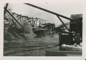
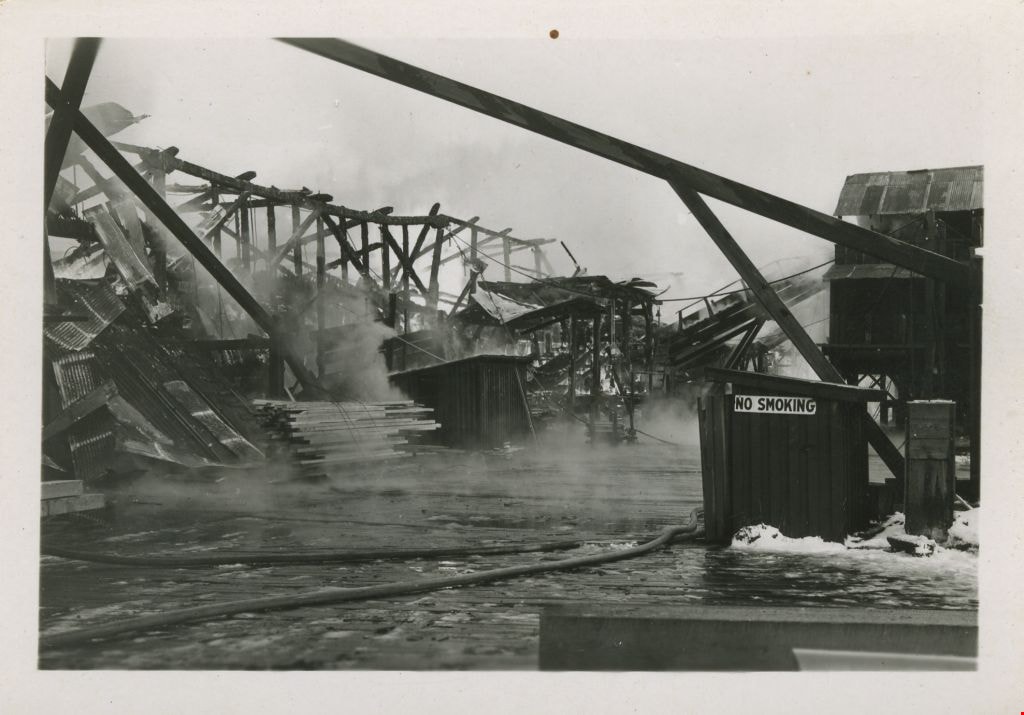
Aftermath of Kapoor Sawmill fire
https://search.heritageburnaby.ca/link/museumdescription1495
- Repository
- Burnaby Village Museum
- Date
- January 1947
- Collection/Fonds
- Burnaby Village Museum Photograph collection
- Description Level
- Item
- Physical Description
- 1 photograph : b&w ; 5 x 7.5 cm
- Scope and Content
- Photograph of the aftermath of the fire at Kapoor Sawmill that took place January 14, 1947. A building frame remains standing on the left along with a large metal-roofed building on the right. In the foreground, a fire hose is visible.
- Repository
- Burnaby Village Museum
- Collection/Fonds
- Burnaby Village Museum Photograph collection
- Description Level
- Item
- Physical Description
- 1 photograph : b&w ; 5 x 7.5 cm
- Scope and Content
- Photograph of the aftermath of the fire at Kapoor Sawmill that took place January 14, 1947. A building frame remains standing on the left along with a large metal-roofed building on the right. In the foreground, a fire hose is visible.
- Names
- Kapoor Sawmills Limited
- Accession Code
- BV999.55.44
- Access Restriction
- No restrictions
- Date
- January 1947
- Media Type
- Photograph
- Historic Neighbourhood
- Barnet (Historic Neighbourhood)
- Planning Study Area
- Burnaby Mountain Area
- Scan Resolution
- 600
- Scan Date
- 09-Jun-09
- Scale
- 100
- Notes
- Title based on contents of photograph
Images
![Barnet Lumber mill, [192-] (date of original), copied 2004 thumbnail](/media/hpo/_Data/_BVM_Images/2019/2019_0032_0051_001.jpg?width=280)
Barnet Lumber mill
https://search.heritageburnaby.ca/link/museumdescription15232
- Repository
- Burnaby Village Museum
- Date
- [192-] (date of original), copied 2004
- Collection/Fonds
- In the Shadow by the Sea collection
- Description Level
- Item
- Physical Description
- 1 photograph (tiff) : 300 dpi
- Scope and Content
- Photograph of the Barnet Lumber Company mill in operation. C.P.R. railroad tracks are visible in the foreground and trees on the north shore of Burrard Inlet are visible in the distance. Plumes of smoke are rising from the mill chimneys.
- Repository
- Burnaby Village Museum
- Collection/Fonds
- In the Shadow by the Sea collection
- Description Level
- Item
- Physical Description
- 1 photograph (tiff) : 300 dpi
- Scope and Content
- Photograph of the Barnet Lumber Company mill in operation. C.P.R. railroad tracks are visible in the foreground and trees on the north shore of Burrard Inlet are visible in the distance. Plumes of smoke are rising from the mill chimneys.
- Names
- Barnet Lumber Company
- Geographic Access
- Burrard Inlet
- Accession Code
- BV019.32.51
- Access Restriction
- No restrictions
- Reproduction Restriction
- No known restrictions
- Date
- [192-] (date of original), copied 2004
- Media Type
- Photograph
- Historic Neighbourhood
- Barnet (Historic Neighbourhood)
- Planning Study Area
- Burnaby Mountain Area
- Notes
- Title based on contents of photograph
Images
![Barnet Lumber mill, [192-] (date of original), copied 2004 thumbnail](/media/hpo/_Data/_BVM_Images/2019/2019_0032_0051_001.jpg)
![Logging chute, [1919] thumbnail](/media/hpo/_Data/_BVM_Images/1974/197500330003aj.jpg?width=280)
Logging chute
https://search.heritageburnaby.ca/link/museumdescription3522
- Repository
- Burnaby Village Museum
- Date
- [1919]
- Collection/Fonds
- Burnaby Village Museum Photograph collection
- Description Level
- Item
- Physical Description
- 1 photograph : sepia ; 13 x 8 cm
- Scope and Content
- Photograph of a logging chute and mill at an unidentified location.
- Repository
- Burnaby Village Museum
- Collection/Fonds
- Burnaby Village Museum Photograph collection
- Description Level
- Item
- Physical Description
- 1 photograph : sepia ; 13 x 8 cm
- Scope and Content
- Photograph of a logging chute and mill at an unidentified location.
- Accession Code
- HV975.33.3aj
- Access Restriction
- No restrictions
- Date
- [1919]
- Media Type
- Photograph
- Scan Resolution
- 600
- Scan Date
- 2/2/2010
- Scale
- 100
- Notes
- Title based on contents of photograph
- Image from personal photograph album of Tom "Tommy" Irvine (HV975.33.3)
Images
![Logging chute, [1919] thumbnail](/media/hpo/_Data/_BVM_Images/1974/197500330003aj.jpg)
![Mill, [1919] thumbnail](/media/hpo/_Data/_BVM_Images/1974/197500330003g.jpg?width=280)
Mill
https://search.heritageburnaby.ca/link/museumdescription3490
- Repository
- Burnaby Village Museum
- Date
- [1919]
- Collection/Fonds
- Burnaby Village Museum Photograph collection
- Description Level
- Item
- Physical Description
- 1 photograph : sepia ; 8 x 13.5 cm
- Scope and Content
- Photograph of an unidentified mill at the water's edge.
- Repository
- Burnaby Village Museum
- Collection/Fonds
- Burnaby Village Museum Photograph collection
- Description Level
- Item
- Physical Description
- 1 photograph : sepia ; 8 x 13.5 cm
- Scope and Content
- Photograph of an unidentified mill at the water's edge.
- Subjects
- Buildings - Industrial - Mills
- Accession Code
- HV975.33.3g
- Access Restriction
- No restrictions
- Date
- [1919]
- Media Type
- Photograph
- Scan Resolution
- 600
- Scan Date
- 2/2/2010
- Scale
- 100
- Notes
- Title based on contents of photograph
- Image from personal photograph album of Tom "Tommy" Irvine (HV975.33.3)
Images
![Mill, [1919] thumbnail](/media/hpo/_Data/_BVM_Images/1974/197500330003g.jpg)
![Mill, [1919] thumbnail](/media/hpo/_Data/_BVM_Images/1974/197500330003al.jpg?width=280)
Mill
https://search.heritageburnaby.ca/link/museumdescription3523
- Repository
- Burnaby Village Museum
- Date
- [1919]
- Collection/Fonds
- Burnaby Village Museum Photograph collection
- Description Level
- Item
- Physical Description
- 1 photograph : sepia ; 13 x 8 cm
- Scope and Content
- Photograph looks to be of a mill at an unidentified location.
- Repository
- Burnaby Village Museum
- Collection/Fonds
- Burnaby Village Museum Photograph collection
- Description Level
- Item
- Physical Description
- 1 photograph : sepia ; 13 x 8 cm
- Scope and Content
- Photograph looks to be of a mill at an unidentified location.
- Accession Code
- HV975.33.3al
- Access Restriction
- No restrictions
- Date
- [1919]
- Media Type
- Photograph
- Scan Resolution
- 600
- Scan Date
- 2/2/2010
- Scale
- 100
- Notes
- Title based on contents of photograph
- Image from personal photograph album of Tom "Tommy" Irvine (HV975.33.3)
Images
![Mill, [1919] thumbnail](/media/hpo/_Data/_BVM_Images/1974/197500330003al.jpg)
![Mill and Water Front, [1924] thumbnail](/media/hpo/_Data/_BVM_Images/1974/197500330003an.jpg?width=280)
Mill and Water Front
https://search.heritageburnaby.ca/link/museumdescription3525
- Repository
- Burnaby Village Museum
- Date
- [1924]
- Collection/Fonds
- Burnaby Village Museum Photograph collection
- Description Level
- Item
- Physical Description
- 1 photograph : sepia ; 8 x 13 cm
- Scope and Content
- Photograph of the mill and waterfront at Powell River.
- Repository
- Burnaby Village Museum
- Collection/Fonds
- Burnaby Village Museum Photograph collection
- Description Level
- Item
- Physical Description
- 1 photograph : sepia ; 8 x 13 cm
- Scope and Content
- Photograph of the mill and waterfront at Powell River.
- Accession Code
- HV975.33.3an
- Access Restriction
- No restrictions
- Date
- [1924]
- Media Type
- Photograph
- Scan Resolution
- 600
- Scan Date
- 2/2/2010
- Scale
- 100
- Notes
- Continuation of title: "...Powell River / B.C."
- Image from personal photograph album of Tom "Tommy" Irvine (HV975.33.3)
Images
![Mill and Water Front, [1924] thumbnail](/media/hpo/_Data/_BVM_Images/1974/197500330003an.jpg)
![Mining structure, [1919] thumbnail](/media/hpo/_Data/_BVM_Images/1974/197500330003az.jpg?width=280)
Mining structure
https://search.heritageburnaby.ca/link/museumdescription3476
- Repository
- Burnaby Village Museum
- Date
- [1919]
- Collection/Fonds
- Burnaby Village Museum Photograph collection
- Description Level
- Item
- Physical Description
- 1 photograph : sepia ; 27 x 17 cm
- Scope and Content
- Photograph of a mining structure. Tom Irvine was involved in the building of the trusses for this structure.
- Repository
- Burnaby Village Museum
- Collection/Fonds
- Burnaby Village Museum Photograph collection
- Description Level
- Item
- Physical Description
- 1 photograph : sepia ; 27 x 17 cm
- Scope and Content
- Photograph of a mining structure. Tom Irvine was involved in the building of the trusses for this structure.
- Subjects
- Buildings - Industrial - Mills
- Accession Code
- HV975.33.3az
- Access Restriction
- No restrictions
- Date
- [1919]
- Media Type
- Photograph
- Scan Resolution
- 600
- Scan Date
- 2/2/2010
- Scale
- 100
- Notes
- Title based on contents of photograph
- Image from personal photograph album of Tom "Tommy" Irvine (HV975.33.3)
Images
![Mining structure, [1919] thumbnail](/media/hpo/_Data/_BVM_Images/1974/197500330003az.jpg)
![Mining structure, [1919] thumbnail](/media/hpo/_Data/_BVM_Images/1974/197500330003h.jpg?width=280)
Mining structure
https://search.heritageburnaby.ca/link/museumdescription3491
- Repository
- Burnaby Village Museum
- Date
- [1919]
- Collection/Fonds
- Burnaby Village Museum Photograph collection
- Description Level
- Item
- Physical Description
- 1 photograph : sepia ; 13.5 x 8 cm
- Scope and Content
- Photograph of mining structure and attached mill. Tom Irvine was involved in the building of the trusses for this structure.
- Repository
- Burnaby Village Museum
- Collection/Fonds
- Burnaby Village Museum Photograph collection
- Description Level
- Item
- Physical Description
- 1 photograph : sepia ; 13.5 x 8 cm
- Scope and Content
- Photograph of mining structure and attached mill. Tom Irvine was involved in the building of the trusses for this structure.
- Subjects
- Buildings - Industrial - Mills
- Accession Code
- HV975.33.3h
- Access Restriction
- No restrictions
- Date
- [1919]
- Media Type
- Photograph
- Scan Resolution
- 600
- Scan Date
- 2/2/2010
- Scale
- 100
- Notes
- Title based on contents of photograph
- Image from personal photograph album of Tom "Tommy" Irvine (HV975.33.3)
Images
![Mining structure, [1919] thumbnail](/media/hpo/_Data/_BVM_Images/1974/197500330003h.jpg)
![Mining structure, [1919] thumbnail](/media/hpo/_Data/_BVM_Images/1974/197500330003w.jpg?width=280)
Mining structure
https://search.heritageburnaby.ca/link/museumdescription3508
- Repository
- Burnaby Village Museum
- Date
- [1919]
- Collection/Fonds
- Burnaby Village Museum Photograph collection
- Description Level
- Item
- Physical Description
- 1 photograph : sepia ; 13.5 x 8 cm
- Scope and Content
- Photograph of mining structure and attached mill. Tom Irvine was involved in the building of the trusses for this structure.
- Repository
- Burnaby Village Museum
- Collection/Fonds
- Burnaby Village Museum Photograph collection
- Description Level
- Item
- Physical Description
- 1 photograph : sepia ; 13.5 x 8 cm
- Scope and Content
- Photograph of mining structure and attached mill. Tom Irvine was involved in the building of the trusses for this structure.
- Subjects
- Buildings - Industrial - Mills
- Accession Code
- HV975.33.3w
- Access Restriction
- No restrictions
- Date
- [1919]
- Media Type
- Photograph
- Scan Resolution
- 600
- Scan Date
- 2/2/2010
- Scale
- 100
- Notes
- Title based on contents of photograph
- Image from personal photograph album of Tom "Tommy" Irvine (HV975.33.3)
Images
![Mining structure, [1919] thumbnail](/media/hpo/_Data/_BVM_Images/1974/197500330003w.jpg)
![Penstocks, [1924] thumbnail](/media/hpo/_Data/_BVM_Images/1974/197500330003r.jpg?width=280)
Penstocks
https://search.heritageburnaby.ca/link/museumdescription3502
- Repository
- Burnaby Village Museum
- Date
- [1924]
- Collection/Fonds
- Burnaby Village Museum Photograph collection
- Description Level
- Item
- Physical Description
- 1 photograph : sepia ; 13 x 8 cm
- Scope and Content
- Photograph of the penstocks at the pulp and paper mill (most likely penstock no.4 in Powell River). Tom Irvine was involved in the building of the trusses for this structure.
- Repository
- Burnaby Village Museum
- Collection/Fonds
- Burnaby Village Museum Photograph collection
- Description Level
- Item
- Physical Description
- 1 photograph : sepia ; 13 x 8 cm
- Scope and Content
- Photograph of the penstocks at the pulp and paper mill (most likely penstock no.4 in Powell River). Tom Irvine was involved in the building of the trusses for this structure.
- Subjects
- Buildings - Industrial - Mills
- Accession Code
- HV975.33.3r
- Access Restriction
- No restrictions
- Date
- [1924]
- Media Type
- Photograph
- Scan Resolution
- 600
- Scan Date
- 2/2/2010
- Scale
- 100
- Notes
- Title based on contents of photograph
- Image from personal photograph album of Tom "Tommy" Irvine (HV975.33.3)
Images
![Penstocks, [1924] thumbnail](/media/hpo/_Data/_BVM_Images/1974/197500330003r.jpg)
![Sawmill, [194-] thumbnail](/media/hpo/_Data/_BVM_Images/1971/197100120075.jpg?width=280)
Sawmill
https://search.heritageburnaby.ca/link/museumdescription7
- Repository
- Burnaby Village Museum
- Date
- [194-]
- Collection/Fonds
- Burnaby Village Museum Photograph collection
- Description Level
- Item
- Physical Description
- 1 photograph : b&w ; 6.8 x 11.4 cm
- Scope and Content
- Photograph of an unidentified labourer standing by stacks of lumber at a sawmill. Another man is seen working behind him. Stamped on back of the photograph reads: "657X." This may be related to the construction of the Willingdon Heights subdivision.
- Repository
- Burnaby Village Museum
- Collection/Fonds
- Burnaby Village Museum Photograph collection
- Description Level
- Item
- Physical Description
- 1 photograph : b&w ; 6.8 x 11.4 cm
- Scope and Content
- Photograph of an unidentified labourer standing by stacks of lumber at a sawmill. Another man is seen working behind him. Stamped on back of the photograph reads: "657X." This may be related to the construction of the Willingdon Heights subdivision.
- Names
- Bingham, Alfred "Alf"
- Accession Code
- HV971.12.75
- Access Restriction
- No restrictions
- Reproduction Restriction
- No known restrictions
- Date
- [194-]
- Media Type
- Photograph
- Historic Neighbourhood
- Vancouver Heights (Historic Neighbourhood)
- Planning Study Area
- Willingdon Heights Area
- Related Material
- The unidentified man from this photograph reappears in photograph HV971.12.78
- Scan Resolution
- 600
- Scan Date
- 2023-03-21
- Notes
- Title based on contents of photograph
Images
![Sawmill, [194-] thumbnail](/media/hpo/_Data/_BVM_Images/1971/197100120075.jpg)
, copied 1978 thumbnail](/media/hpo/_Data/_BVM_Images/1978/1978_0001_0003_001.jpg?width=280)
Haszard house
https://search.heritageburnaby.ca/link/museumdescription449
- Repository
- Burnaby Village Museum
- Date
- [190-](date of original), copied 1978
- Collection/Fonds
- Burnaby Village Museum Photograph collection
- Description Level
- Item
- Physical Description
- 1 photograph : b&w ; 20.2 x 25.2 cm print
- Scope and Content
- Photograph of a house in a clearing just on the outskirts of densely wooded area. There is a wooden fence around the property, and in front of the house is a dirt road. There are small piles of logs along the road side. An earlier catalogue record identifies this house as the Haszard house that was…
- Repository
- Burnaby Village Museum
- Collection/Fonds
- Burnaby Village Museum Photograph collection
- Description Level
- Item
- Physical Description
- 1 photograph : b&w ; 20.2 x 25.2 cm print
- Scope and Content
- Photograph of a house in a clearing just on the outskirts of densely wooded area. There is a wooden fence around the property, and in front of the house is a dirt road. There are small piles of logs along the road side. An earlier catalogue record identifies this house as the Haszard house that was located across the street from the property of the Sprott Farm. The photograph was taken from Douglas Road (later renamed in part Canada Way). It is also noted that the Sprott family lived in the Haszard house while their home, named "Dovecote" was being completed.
- Geographic Access
- Douglas Road
- Canada Way
- Accession Code
- HV978.1.3
- Access Restriction
- No restrictions
- Reproduction Restriction
- No known restrictions
- Date
- [190-](date of original), copied 1978
- Media Type
- Photograph
- Historic Neighbourhood
- Burnaby Lake (Historic Neighbourhood)
- Scan Resolution
- 600
- Scan Date
- 2023-07-25
- Notes
- Title based on contents of photograph
Images
, copied 1978 thumbnail](/media/hpo/_Data/_BVM_Images/1978/1978_0001_0003_001.jpg)
![Ada Bingham by a tree stump, [1948] thumbnail](/media/hpo/_Data/_BVM_Images/1976/1976_0046_0005_001.jpg?width=280)
Ada Bingham by a tree stump
https://search.heritageburnaby.ca/link/museumdescription739
- Repository
- Burnaby Village Museum
- Date
- [1948]
- Collection/Fonds
- Burnaby Village Museum Photograph collection
- Description Level
- Item
- Physical Description
- 1 photograph : b&w ; 11.3 x 6.8 cm
- Scope and Content
- Photograph of Mary Ada Bingham standing in front of a giant tree stump in Willingdon Heights which was to be cleared for a veterans' housing project in 1948. According to an accompanying note prepared by Burnaby Village Museum, and supported by the inscription on the photograph, Ada Bingham came to…
- Repository
- Burnaby Village Museum
- Collection/Fonds
- Burnaby Village Museum Photograph collection
- Description Level
- Item
- Physical Description
- 1 photograph : b&w ; 11.3 x 6.8 cm
- Material Details
- Inscribed in black ballpoint pen, on the back of the photo: "Ada and Big Stump / Clearing time on Willingdon Heights / 1948. / Burnaby 2. B. C" and in blue ballpoint pen: "Mrs. Mary Ada Bingham / 1 Real Pioneer Wife; she helped me clear the land. Build our home, dig out well and worked for the community for nearly 50 years. She died August 9, 1969 / Alf Bingham."
- Scope and Content
- Photograph of Mary Ada Bingham standing in front of a giant tree stump in Willingdon Heights which was to be cleared for a veterans' housing project in 1948. According to an accompanying note prepared by Burnaby Village Museum, and supported by the inscription on the photograph, Ada Bingham came to Burnaby to homestead with her husband, Alfred "Alf" Bingham, in 1919. They settled in the Lochdale district of North Burnaby but later moved to Parker Street.
- Subjects
- Land Clearing
- Plants - Trees
- Names
- Bingham, Mary Ada "Ada"
- Accession Code
- HV976.46.5
- Access Restriction
- No restrictions
- Reproduction Restriction
- No known restrictions
- Date
- [1948]
- Media Type
- Photograph
- Historic Neighbourhood
- Vancouver Heights (Historic Neighbourhood)
- Planning Study Area
- Willingdon Heights Area
- Scan Resolution
- 600
- Scan Date
- 2023-06-20
- Notes
- Title based on contents of photograph
Images
![Ada Bingham by a tree stump, [1948] thumbnail](/media/hpo/_Data/_BVM_Images/1976/1976_0046_0005_001.jpg)
![Bulldozer clearing a Forested Hill, [194-] thumbnail](/media/hpo/_Data/_BVM_Images/1971/197100120079.jpg?width=280)
Bulldozer clearing a Forested Hill
https://search.heritageburnaby.ca/link/museumdescription11
- Repository
- Burnaby Village Museum
- Date
- [194-]
- Collection/Fonds
- Burnaby Village Museum Photograph collection
- Description Level
- Item
- Physical Description
- 1 photograph : b&w ; 6.8 x 11.5 cm
- Scope and Content
- Photograph of a man operating a bulldozer clearing a forested hill. There appears to be a backhoe on the other side of the hill of fallen and upturned trees. This may be the site of the Willingdon Heights subdivision. Stamped on back of photograph: "342X."
- Repository
- Burnaby Village Museum
- Collection/Fonds
- Burnaby Village Museum Photograph collection
- Description Level
- Item
- Physical Description
- 1 photograph : b&w ; 6.8 x 11.5 cm
- Scope and Content
- Photograph of a man operating a bulldozer clearing a forested hill. There appears to be a backhoe on the other side of the hill of fallen and upturned trees. This may be the site of the Willingdon Heights subdivision. Stamped on back of photograph: "342X."
- Names
- Bingham, Alfred "Alf"
- Accession Code
- HV971.12.79
- Access Restriction
- No restrictions
- Reproduction Restriction
- No known restrictions
- Date
- [194-]
- Media Type
- Photograph
- Historic Neighbourhood
- Vancouver Heights (Historic Neighbourhood)
- Planning Study Area
- Willingdon Heights Area
- Scan Resolution
- 600
- Scan Date
- 2023-03-21
- Notes
- Title based on contents of photograph
Images
![Bulldozer clearing a Forested Hill, [194-] thumbnail](/media/hpo/_Data/_BVM_Images/1971/197100120079.jpg)
![Bulldozer clearing a lot, [194-] thumbnail](/media/hpo/_Data/_BVM_Images/1971/197100120081.jpg?width=280)
Bulldozer clearing a lot
https://search.heritageburnaby.ca/link/museumdescription13
- Repository
- Burnaby Village Museum
- Date
- [194-]
- Collection/Fonds
- Burnaby Village Museum Photograph collection
- Description Level
- Item
- Physical Description
- 1 photograph : sepia ; 6.8 x 11.3 cm
- Scope and Content
- Photograph of an unidentified man operating a bulldozer and clearing the lot. This may be the site of the Willingdon Heights subdivision. Stamped on back of photograph: "345L."
- Repository
- Burnaby Village Museum
- Collection/Fonds
- Burnaby Village Museum Photograph collection
- Description Level
- Item
- Physical Description
- 1 photograph : sepia ; 6.8 x 11.3 cm
- Scope and Content
- Photograph of an unidentified man operating a bulldozer and clearing the lot. This may be the site of the Willingdon Heights subdivision. Stamped on back of photograph: "345L."
- Names
- Bingham, Alfred "Alf"
- Accession Code
- HV971.12.81
- Access Restriction
- No restrictions
- Reproduction Restriction
- No known restrictions
- Date
- [194-]
- Media Type
- Photograph
- Historic Neighbourhood
- Vancouver Heights (Historic Neighbourhood)
- Planning Study Area
- Willingdon Heights Area
- Scan Resolution
- 600
- Scan Date
- 2023-03-21
- Notes
- Title based on contents of photograph
Images
![Bulldozer clearing a lot, [194-] thumbnail](/media/hpo/_Data/_BVM_Images/1971/197100120081.jpg)
, copied 1978 thumbnail](/media/hpo/_Data/_BVM_Images/1977/197800010016.jpg?width=280)
Cleared land
https://search.heritageburnaby.ca/link/museumdescription462
- Repository
- Burnaby Village Museum
- Date
- [190-](date of original), copied 1978
- Collection/Fonds
- Burnaby Village Museum Photograph collection
- Description Level
- Item
- Physical Description
- 1 photograph : b&w ; 20.2 x 25.2 cm print
- Scope and Content
- Photograph of the cleared land which appears to be the Sprott family property. There are stumps and felled trees on the lot. Across a small dirt road and behind a wooden fence, the Haszard house is visible to the extreme right of the photograph.
- Repository
- Burnaby Village Museum
- Collection/Fonds
- Burnaby Village Museum Photograph collection
- Description Level
- Item
- Physical Description
- 1 photograph : b&w ; 20.2 x 25.2 cm print
- Scope and Content
- Photograph of the cleared land which appears to be the Sprott family property. There are stumps and felled trees on the lot. Across a small dirt road and behind a wooden fence, the Haszard house is visible to the extreme right of the photograph.
- Subjects
- Land Clearing
- Plants - Trees
- Geographic Access
- Canada Way
- Accession Code
- HV978.1.16
- Access Restriction
- No restrictions
- Reproduction Restriction
- No known restrictions
- Date
- [190-](date of original), copied 1978
- Media Type
- Photograph
- Historic Neighbourhood
- Burnaby Lake (Historic Neighbourhood)
- Scan Resolution
- 600
- Scan Date
- 2023-08-01
- Notes
- Title based on contents of photograph
Images
, copied 1978 thumbnail](/media/hpo/_Data/_BVM_Images/1977/197800010016.jpg)
![Cleared lot, [1948] thumbnail](/media/hpo/_Data/_BVM_Images/1971/197100120085.jpg?width=280)
Cleared lot
https://search.heritageburnaby.ca/link/museumdescription17
- Repository
- Burnaby Village Museum
- Date
- [1948]
- Collection/Fonds
- Burnaby Village Museum Photograph collection
- Description Level
- Item
- Physical Description
- 1 photograph : b&w ; 6.8 x 11.3 cm
- Scope and Content
- Photograph of a large cleared lot with two houses built apart from each other. Catalogue information from 1976 indicates that the photograph depicts the development of one of Burnaby's streets, ca. 1948. This may be the site of the Willingdon Heights subdivision. Stamped on back of photo: "657X."
- Repository
- Burnaby Village Museum
- Collection/Fonds
- Burnaby Village Museum Photograph collection
- Description Level
- Item
- Physical Description
- 1 photograph : b&w ; 6.8 x 11.3 cm
- Scope and Content
- Photograph of a large cleared lot with two houses built apart from each other. Catalogue information from 1976 indicates that the photograph depicts the development of one of Burnaby's streets, ca. 1948. This may be the site of the Willingdon Heights subdivision. Stamped on back of photo: "657X."
- Subjects
- Land Clearing
- Names
- Bingham, Alfred "Alf"
- Accession Code
- HV971.12.85
- Access Restriction
- No restrictions
- Reproduction Restriction
- No known restrictions
- Date
- [1948]
- Media Type
- Photograph
- Historic Neighbourhood
- Vancouver Heights (Historic Neighbourhood)
- Planning Study Area
- Willingdon Heights Area
- Scan Resolution
- 600
- Scan Date
- 2023-03-21
- Notes
- Title based on contents of photograph
Images
![Cleared lot, [1948] thumbnail](/media/hpo/_Data/_BVM_Images/1971/197100120085.jpg)
![Douglas Road, [1897] (date of original), copied 1978 thumbnail](/media/hpo/_Data/_BVM_Images/1978/1978_0001_0001_001.jpg?width=280)
Douglas Road
https://search.heritageburnaby.ca/link/museumdescription447
- Repository
- Burnaby Village Museum
- Date
- [1897] (date of original), copied 1978
- Collection/Fonds
- Burnaby Village Museum Photograph collection
- Description Level
- Item
- Physical Description
- 1 photograph : b&w ; 20.2 x 25.2 cm print
- Scope and Content
- Photograph of Douglas Road (later renamed in part Canada Way), near Stanley Street. To the right is the Sprott family property, where a few wooden buildings are visible in the cleared area. Charles Sprott, head of the Sprott family, was an important Burnaby politician who was continuously elected t…
- Repository
- Burnaby Village Museum
- Collection/Fonds
- Burnaby Village Museum Photograph collection
- Description Level
- Item
- Physical Description
- 1 photograph : b&w ; 20.2 x 25.2 cm print
- Scope and Content
- Photograph of Douglas Road (later renamed in part Canada Way), near Stanley Street. To the right is the Sprott family property, where a few wooden buildings are visible in the cleared area. Charles Sprott, head of the Sprott family, was an important Burnaby politician who was continuously elected to serve in the municiality as councillor from 1895 to 1903 and as Reeve from 1904 to 1905.
- Subjects
- Geographic Features - Roads
- Land Clearing
- Geographic Access
- Douglas Road
- Canada Way
- Stanley Street
- Accession Code
- HV978.1.1
- Access Restriction
- No restrictions
- Reproduction Restriction
- No known restrictions
- Date
- [1897] (date of original), copied 1978
- Media Type
- Photograph
- Historic Neighbourhood
- Burnaby Lake (Historic Neighbourhood)
- Planning Study Area
- Lakeview-Mayfield Area
- Scan Resolution
- 600
- Scan Date
- 2023-07-25
- Notes
- Title based on contents of photograph
Images
![Douglas Road, [1897] (date of original), copied 1978 thumbnail](/media/hpo/_Data/_BVM_Images/1978/1978_0001_0001_001.jpg)

Land being cleared for Saint Theresa's Roman Catholic Church
https://search.heritageburnaby.ca/link/museumdescription902
- Repository
- Burnaby Village Museum
- Date
- 1929
- Collection/Fonds
- Burnaby Village Museum Photograph collection
- Description Level
- Item
- Physical Description
- 1 photograph : b&w ; 6.7 x 11.4 cm
- Scope and Content
- Photograph of three unidentified men standing on Douglas Road (later renamed in part Canada Way) with Laurel Street in the background on the left and the site of Saint Theresa's Roman Catholic Church as a lot with blackened stumps. The church was located at the southeast corner of Canada Way and L…
- Repository
- Burnaby Village Museum
- Collection/Fonds
- Burnaby Village Museum Photograph collection
- Description Level
- Item
- Physical Description
- 1 photograph : b&w ; 6.7 x 11.4 cm
- Scope and Content
- Photograph of three unidentified men standing on Douglas Road (later renamed in part Canada Way) with Laurel Street in the background on the left and the site of Saint Theresa's Roman Catholic Church as a lot with blackened stumps. The church was located at the southeast corner of Canada Way and Laurel Street. According to an accompanying note located with the photograph, the first church building burned to the ground the night before it was to be blessed. Insurance for the church had been arranged for by Colonel Dorrell only hours before it was burned and even though signatures had not been affixed to the policy, the insurance company honoured the claim. The second building was smaller and had no basement. Father Trainer was the first priest. This church was torn down in 1974 and a new church building was erected across the road on Canada Way.
- Subjects
- Land Clearing
- Geographic Access
- Douglas Road
- Canada Way
- Laurel Street
- Accession Code
- HV975.105.1
- Access Restriction
- No restrictions
- Reproduction Restriction
- No known restrictions
- Date
- 1929
- Media Type
- Photograph
- Historic Neighbourhood
- Burnaby Lake (Historic Neighbourhood)
- Planning Study Area
- Douglas-Gilpin Area
- Scan Resolution
- 600
- Scan Date
- 2023-06-06
- Notes
- Title based on contents of photograph
- Information on the scope and content of the photograph is taken from an acquisition record from the time of the accession
Images

![Land clearing, [190-] (date of original), copied 1978 thumbnail](/media/hpo/_Data/_BVM_Images/1977/197800010007.jpg?width=280)
Land clearing
https://search.heritageburnaby.ca/link/museumdescription453
- Repository
- Burnaby Village Museum
- Date
- [190-] (date of original), copied 1978
- Collection/Fonds
- Burnaby Village Museum Photograph collection
- Description Level
- Item
- Physical Description
- 1 photograph : b&w ; 20.2 x 25.2 cm print
- Scope and Content
- Photograph of a cleared property with a thick wooded area just behind it. There is a house in the back to the extreme left of the photograph that has been identified as the Haszard house where the Sprott family stayed while building their farmhouse known as "Dovecote." There are unidentified men i…
- Repository
- Burnaby Village Museum
- Collection/Fonds
- Burnaby Village Museum Photograph collection
- Description Level
- Item
- Physical Description
- 1 photograph : b&w ; 20.2 x 25.2 cm print
- Scope and Content
- Photograph of a cleared property with a thick wooded area just behind it. There is a house in the back to the extreme left of the photograph that has been identified as the Haszard house where the Sprott family stayed while building their farmhouse known as "Dovecote." There are unidentified men in the cleared field.
- Subjects
- Land Clearing
- Geographic Access
- Canada Way
- Accession Code
- HV978.1.7
- Access Restriction
- No restrictions
- Reproduction Restriction
- No known restrictions
- Date
- [190-] (date of original), copied 1978
- Media Type
- Photograph
- Historic Neighbourhood
- Burnaby Lake (Historic Neighbourhood)
- Scan Resolution
- 600
- Scan Date
- 2023-08-01
- Notes
- Title based on contents of photograph
Images
![Land clearing, [190-] (date of original), copied 1978 thumbnail](/media/hpo/_Data/_BVM_Images/1977/197800010007.jpg)