More like 'Alfred Bingham's writings - Track 1'
Narrow Results By
Subject
- Accidents 1
- Accidents - Automobile Accidents 1
- Advertising Medium 2
- Advertising Medium - Signs and Signboards 41
- Aerial Photographs 38
- Agricultural Tools and Equipment 2
- Agricultural Tools and Equipment - Gardening Equipment 4
- Agricultural Tools and Equipment - Plows 2
- Agriculture 2
- Agriculture - Farms 12
- Agriculture - Fruit and Berries 3
- Animals 4

Loading Strawberries, BCERy, Douglas Road, Burnaby BC
https://search.heritageburnaby.ca/link/archivedescription66211
- Repository
- City of Burnaby Archives
- Date
- 1894
- Collection/Fonds
- Peers Family and Hill Family fonds
- Description Level
- Item
- Physical Description
- 1 photograph : b&w ; 13 x 18 cm on cardboard 22 x 27.5 cm
- Scope and Content
- Photograph of a group of farmers loading their crates onto a railway car. Identified (left to right), Bernard R. Hill, Louis Claude Hill, Charles Frederick Sprott, George E. Clayton, and Louis "Edgar" Sprott, who are loading up their strawberries on a street car. The farmers are lined up in a row,…
- Repository
- City of Burnaby Archives
- Date
- 1894
- Collection/Fonds
- Peers Family and Hill Family fonds
- Physical Description
- 1 photograph : b&w ; 13 x 18 cm on cardboard 22 x 27.5 cm
- Description Level
- Item
- Record No.
- 477-938
- Access Restriction
- No restrictions
- Reproduction Restriction
- No known restrictions
- Accession Number
- 2007-12
- Scope and Content
- Photograph of a group of farmers loading their crates onto a railway car. Identified (left to right), Bernard R. Hill, Louis Claude Hill, Charles Frederick Sprott, George E. Clayton, and Louis "Edgar" Sprott, who are loading up their strawberries on a street car. The farmers are lined up in a row, each sitting in their own horse and cart as they bring their strawberries to the station.
- Subjects
- Agriculture - Fruit and Berries
- Transportation - Electric Railroads
- Transportation - Horses
- Transportation - Carts
- Occupations - Farmers
- Transportation - Wagons
- Officials - Mayors and Reeves
- Names
- British Columbia Electric Railway Company
- Hill, Louis Claude "Claude"
- Hill, Bernard R.
- Every-Clayton, George
- Sprott, Louis "Edgar"
- Sprott, Charles Frederick
- Media Type
- Photograph
- Notes
- Title based on contents of photograph
- Caption on recto of photograph reads: "Loading Strawberries, B.C.E.Ry., Douglas Rd., Burnaby, B.C."
- Geographic Access
- Douglas Road
- Historic Neighbourhood
- Burnaby Lake (Historic Neighbourhood)
Images


Douglas Road
https://search.heritageburnaby.ca/link/archivedescription35897
- Repository
- City of Burnaby Archives
- Date
- 1895 (date of original), copied 1986
- Collection/Fonds
- Burnaby Historical Society fonds
- Description Level
- Item
- Physical Description
- 1 photograph : b&w ; 12.7 x 17.8 cm print
- Scope and Content
- Photograph of Douglas Road at Haszard Hill.
- Repository
- City of Burnaby Archives
- Date
- 1895 (date of original), copied 1986
- Collection/Fonds
- Burnaby Historical Society fonds
- Subseries
- Pioneer Tales subseries
- Physical Description
- 1 photograph : b&w ; 12.7 x 17.8 cm print
- Description Level
- Item
- Record No.
- 204-756
- Access Restriction
- No restrictions
- Reproduction Restriction
- No known restrictions
- Accession Number
- BHS1988-03
- Scope and Content
- Photograph of Douglas Road at Haszard Hill.
- Subjects
- Geographic Features - Roads
- Media Type
- Photograph
- Notes
- Title based on contents of photograph
- Type note under photograph reads, "Douglas Road, 1895. Deviation from old road, seen on right at, then, Haszard Hill, now Rayside Ave, looking eastward up the hill."
- Geographic Access
- Douglas Road
- Historic Neighbourhood
- Burnaby Lake (Historic Neighbourhood)
- Planning Study Area
- Morley-Buckingham Area
Images

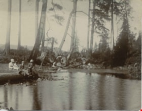
Deer Lake Near Outflow
https://search.heritageburnaby.ca/link/archivedescription39421
- Repository
- City of Burnaby Archives
- Date
- 1897
- Collection/Fonds
- Peers Family and Hill Family fonds
- Description Level
- Item
- Physical Description
- 1 photograph : b&w ; 10 x 12.6 cm
- Scope and Content
- Photograph of three unidentified people sitting on the bank of Deer Lake. Cleared land and felled trees can be seen in the background.
- Repository
- City of Burnaby Archives
- Date
- 1897
- Collection/Fonds
- Peers Family and Hill Family fonds
- Physical Description
- 1 photograph : b&w ; 10 x 12.6 cm
- Description Level
- Item
- Record No.
- 477-740
- Access Restriction
- No restrictions
- Reproduction Restriction
- No known restrictions
- Accession Number
- 2007-12
- Scope and Content
- Photograph of three unidentified people sitting on the bank of Deer Lake. Cleared land and felled trees can be seen in the background.
- Media Type
- Photograph
- Notes
- Title based on caption accompanying photograph
- Geographic Access
- Deer Lake
- Historic Neighbourhood
- Burnaby Lake (Historic Neighbourhood)
Images

![Douglas Road, [1897] (date of original), copied 1978 thumbnail](/media/hpo/_Data/_BVM_Images/1978/1978_0001_0001_001.jpg?width=280)
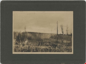
Douglas Road
https://search.heritageburnaby.ca/link/museumdescription447
- Repository
- Burnaby Village Museum
- Date
- [1897] (date of original), copied 1978
- Collection/Fonds
- Burnaby Village Museum Photograph collection
- Description Level
- Item
- Physical Description
- 1 photograph : b&w ; 20.2 x 25.2 cm print
- Scope and Content
- Photograph of Douglas Road (later renamed in part Canada Way), near Stanley Street. To the right is the Sprott family property, where a few wooden buildings are visible in the cleared area. Charles Sprott, head of the Sprott family, was an important Burnaby politician who was continuously elected t…
- Repository
- Burnaby Village Museum
- Collection/Fonds
- Burnaby Village Museum Photograph collection
- Description Level
- Item
- Physical Description
- 1 photograph : b&w ; 20.2 x 25.2 cm print
- Scope and Content
- Photograph of Douglas Road (later renamed in part Canada Way), near Stanley Street. To the right is the Sprott family property, where a few wooden buildings are visible in the cleared area. Charles Sprott, head of the Sprott family, was an important Burnaby politician who was continuously elected to serve in the municiality as councillor from 1895 to 1903 and as Reeve from 1904 to 1905.
- Subjects
- Geographic Features - Roads
- Land Clearing
- Geographic Access
- Douglas Road
- Canada Way
- Stanley Street
- Accession Code
- HV978.1.1
- Access Restriction
- No restrictions
- Reproduction Restriction
- No known restrictions
- Date
- [1897] (date of original), copied 1978
- Media Type
- Photograph
- Historic Neighbourhood
- Burnaby Lake (Historic Neighbourhood)
- Planning Study Area
- Lakeview-Mayfield Area
- Scan Resolution
- 600
- Scan Date
- 2023-07-25
- Notes
- Title based on contents of photograph
Images
![Douglas Road, [1897] (date of original), copied 1978 thumbnail](/media/hpo/_Data/_BVM_Images/1978/1978_0001_0001_001.jpg)

People next to a large fallen tree
https://search.heritageburnaby.ca/link/archivedescription39514
- Repository
- City of Burnaby Archives
- Date
- 1898
- Collection/Fonds
- Peers Family and Hill Family fonds
- Description Level
- Item
- Physical Description
- 1 photograph : sepia ; 9.8 x 13.5 cm on page 21.5 x 28 cm (pasted in album)
- Scope and Content
- Photograph of a group of people next to a very large fallen tree. The photograph was taken just above Deer Lake Avenue and the home of Bernard Hill can be seen in the background. Identified in the picture are Mrs. Sprott (standing in front of tree to the left), directly in front of her, lying on th…
- Repository
- City of Burnaby Archives
- Date
- 1898
- Collection/Fonds
- Peers Family and Hill Family fonds
- Physical Description
- 1 photograph : sepia ; 9.8 x 13.5 cm on page 21.5 x 28 cm (pasted in album)
- Description Level
- Item
- Record No.
- 477-833
- Access Restriction
- No restrictions
- Reproduction Restriction
- No known restrictions
- Accession Number
- 2007-12
- Scope and Content
- Photograph of a group of people next to a very large fallen tree. The photograph was taken just above Deer Lake Avenue and the home of Bernard Hill can be seen in the background. Identified in the picture are Mrs. Sprott (standing in front of tree to the left), directly in front of her, lying on the ground is Bernard Hill. The woman standing farthest to the right (next to man holding child) is Marian Hill and next to her is Claude Hill holding his daughter Kitty. The man farthest to the right is Mr. Sprott. The rest are unidentified.
- Subjects
- Land Clearing
- Plants - Trees
- Names
- Hill, Bernard R.
- Hill, Marian Berkeley
- Hill, Louis Claude "Claude"
- Peers, Katherine Maude Hill "Kitty"
- Media Type
- Photograph
- Notes
- Title based on caption accompanying photograph
- Geographic Access
- Deer Lake Avenue
- Historic Neighbourhood
- Burnaby Lake (Historic Neighbourhood)
- Planning Study Area
- Douglas-Gilpin Area
Images

![Burnaby's first Municipal Hall, [between 1899 and 1911] (date of original), copied 1995 thumbnail](/media/hpo/_Data/_Archives_Images/_Unrestricted/316/316-006.jpg?width=280)
Burnaby's first Municipal Hall
https://search.heritageburnaby.ca/link/archivedescription37100
- Repository
- City of Burnaby Archives
- Date
- [between 1899 and 1911] (date of original), copied 1995
- Collection/Fonds
- Burnaby Historical Society fonds
- Description Level
- Item
- Physical Description
- 1 photograph : b&w ; 10 x 15 cm print
- Scope and Content
- Photograph of council members and others sitting and standing on the steps of Burnaby's first Municipal Hall.
- Repository
- City of Burnaby Archives
- Date
- [between 1899 and 1911] (date of original), copied 1995
- Collection/Fonds
- Burnaby Historical Society fonds
- Subseries
- Byrne family subseries
- Physical Description
- 1 photograph : b&w ; 10 x 15 cm print
- Description Level
- Item
- Record No.
- 316-006
- Access Restriction
- No restrictions
- Reproduction Restriction
- No known restrictions
- Accession Number
- BHS1995-04
- Scope and Content
- Photograph of council members and others sitting and standing on the steps of Burnaby's first Municipal Hall.
- Names
- Burnaby City Hall
- Media Type
- Photograph
- Notes
- Title based on contents of photograph
- Geographic Access
- Kingsway
- Street Address
- 7252 Kingsway
- Historic Neighbourhood
- Edmonds (Historic Neighbourhood)
- Planning Study Area
- Stride Avenue Area
Images
![Burnaby's first Municipal Hall, [between 1899 and 1911] (date of original), copied 1995 thumbnail](/media/hpo/_Data/_Archives_Images/_Unrestricted/316/316-006.jpg)
Looking from Woodlunds towards Burnaby Lake in 1899
https://search.heritageburnaby.ca/link/museumdescription992
- Repository
- Burnaby Village Museum
- Date
- 1899
- Collection/Fonds
- Burnaby Village Museum Photograph collection
- Description Level
- Item
- Physical Description
- 1 photograph : sepia photogravure ; 9.8 x 13.9 cm, mounted on cardboard 14.5 x 19.7 cm
- Scope and Content
- Photograph taken from "Woodlunds." Annotations in ink on the back of the card read, "Mr & Mrs G. Every-Clayton/ with Mr Haszard's/ wishes for a very/ Happy Xmas/ 1899" and "Looking from Woodlands / towards Burnaby Lake in 1899." Later annotation in blue ballpoint pen read, "Woodlunds the residence…
- Repository
- Burnaby Village Museum
- Collection/Fonds
- Burnaby Village Museum Photograph collection
- Description Level
- Item
- Physical Description
- 1 photograph : sepia photogravure ; 9.8 x 13.9 cm, mounted on cardboard 14.5 x 19.7 cm
- Scope and Content
- Photograph taken from "Woodlunds." Annotations in ink on the back of the card read, "Mr & Mrs G. Every-Clayton/ with Mr Haszard's/ wishes for a very/ Happy Xmas/ 1899" and "Looking from Woodlands / towards Burnaby Lake in 1899." Later annotation in blue ballpoint pen read, "Woodlunds the residence of Mr. Geo. Every-Clayton stood on the site of the present Centennial Pavilion, which when originally built was the residence of Mr. and Mrs. H.T. Ceperley. The proceeds from its sale was used to prepare the Ceperley playground in Stanley Park. The house in the left centre was that of Mr. and Mrs. Bernard R. Hill demolished to make way for entrance to Expressway."
- Names
- Every-Clayton, George
- Geographic Access
- Burnaby Lake
- Accession Code
- HV973.40.6
- Access Restriction
- No restrictions
- Reproduction Restriction
- No known restrictions
- Date
- 1899
- Media Type
- Photograph
- Scan Resolution
- 600
- Scan Date
- 2023-05-09
- Scale
- 100
- Notes
- Title based on contents of photograph
Images


Kingsway
https://search.heritageburnaby.ca/link/archivedescription35874
- Repository
- City of Burnaby Archives
- Date
- 1900 (date of original), copied 1986
- Collection/Fonds
- Burnaby Historical Society fonds
- Description Level
- Item
- Physical Description
- 1 photograph : b&w ; 12.7 x 17.8 cm print
- Scope and Content
- Photograph of Kingsway (then Westminster Road), looking east from Boundary Road near Central Park. Included in the photograph; Central Park Presbyterian Church, Masonic Hall and Reid's Hall.
- Repository
- City of Burnaby Archives
- Date
- 1900 (date of original), copied 1986
- Collection/Fonds
- Burnaby Historical Society fonds
- Subseries
- Pioneer Tales subseries
- Physical Description
- 1 photograph : b&w ; 12.7 x 17.8 cm print
- Description Level
- Item
- Record No.
- 204-733
- Access Restriction
- No restrictions
- Reproduction Restriction
- No known restrictions
- Accession Number
- BHS1988-03
- Scope and Content
- Photograph of Kingsway (then Westminster Road), looking east from Boundary Road near Central Park. Included in the photograph; Central Park Presbyterian Church, Masonic Hall and Reid's Hall.
- Subjects
- Buildings - Recreational - Community Halls
- Buildings - Religious - Churches
- Geographic Features - Roads
- Media Type
- Photograph
- Notes
- Title based on contents of photograph
- Geographic Access
- Westminster Avenue
- Kingsway
- Street Address
- 3777 Kingsway
- Historic Neighbourhood
- Central Park (Historic Neighbourhood)
- Planning Study Area
- Garden Village Area
Images

![Men walking down a road, [1900] thumbnail](/media/hpo/_Data/_Archives_Images/_Unrestricted/371/380-001.jpg?width=280)
Men walking down a road
https://search.heritageburnaby.ca/link/archivedescription38273
- Repository
- City of Burnaby Archives
- Date
- [1900]
- Collection/Fonds
- Burnaby Historical Society fonds
- Description Level
- Item
- Physical Description
- 1 photograph : sepia ; 5.7 x 8.2 cm
- Scope and Content
- Photograph of three men walking down an unidentified road.
- Repository
- City of Burnaby Archives
- Date
- [1900]
- Collection/Fonds
- Burnaby Historical Society fonds
- Subseries
- Photographs subseries
- Physical Description
- 1 photograph : sepia ; 5.7 x 8.2 cm
- Description Level
- Item
- Record No.
- 380-001
- Access Restriction
- No restrictions
- Reproduction Restriction
- No known restrictions
- Accession Number
- BHS2007-04
- Scope and Content
- Photograph of three men walking down an unidentified road.
- Subjects
- Geographic Features - Roads
- Media Type
- Photograph
- Notes
- Title based on contents of photograph
Images
![Men walking down a road, [1900] thumbnail](/media/hpo/_Data/_Archives_Images/_Unrestricted/371/380-001.jpg)
![Lake, [1900] thumbnail](/media/hpo/_Data/_Archives_Images/_Unrestricted/477/477-172.jpg?width=280)
Lake
https://search.heritageburnaby.ca/link/archivedescription38853
- Repository
- City of Burnaby Archives
- Date
- [1900]
- Collection/Fonds
- Peers Family and Hill Family fonds
- Description Level
- Item
- Physical Description
- 1 photograph : b&w ; 5.5 x 8 cm on mat 10.2 x 12.8 cm
- Scope and Content
- Photograph of what is most likely Deer Lake.
- Repository
- City of Burnaby Archives
- Date
- [1900]
- Collection/Fonds
- Peers Family and Hill Family fonds
- Physical Description
- 1 photograph : b&w ; 5.5 x 8 cm on mat 10.2 x 12.8 cm
- Description Level
- Item
- Record No.
- 477-172
- Access Restriction
- No restrictions
- Reproduction Restriction
- No known restrictions
- Accession Number
- 2007-12
- Scope and Content
- Photograph of what is most likely Deer Lake.
- Media Type
- Photograph
- Notes
- Title based on contents of photograph
- Geographic Access
- Deer Lake
- Historic Neighbourhood
- Burnaby Lake (Historic Neighbourhood)
Images
![Lake, [1900] thumbnail](/media/hpo/_Data/_Archives_Images/_Unrestricted/477/477-172.jpg)

Deer Lake
https://search.heritageburnaby.ca/link/archivedescription39434
- Repository
- City of Burnaby Archives
- Date
- 1900
- Collection/Fonds
- Peers Family and Hill Family fonds
- Description Level
- Item
- Physical Description
- 1 photograph : b&w ; 9.8 x 14 cm on mat 10.7 x 16.5 cm
- Scope and Content
- Photograph of an aboriginal dugout canoe on Deer Lake. The photograph was taken at the creek looking towards what would become the Oakalla Prison farm site.
- Repository
- City of Burnaby Archives
- Date
- 1900
- Collection/Fonds
- Peers Family and Hill Family fonds
- Physical Description
- 1 photograph : b&w ; 9.8 x 14 cm on mat 10.7 x 16.5 cm
- Description Level
- Item
- Record No.
- 477-753
- Access Restriction
- No restrictions
- Reproduction Restriction
- No known restrictions
- Accession Number
- 2007-12
- Scope and Content
- Photograph of an aboriginal dugout canoe on Deer Lake. The photograph was taken at the creek looking towards what would become the Oakalla Prison farm site.
- Media Type
- Photograph
- Notes
- Title based on caption accompanying photograph
- Geographic Access
- Deer Lake
- Historic Neighbourhood
- Burnaby Lake (Historic Neighbourhood)
- Planning Study Area
- Burnaby Lake Area
Images


Claude Hill beside a large felled tree
https://search.heritageburnaby.ca/link/archivedescription39517
- Repository
- City of Burnaby Archives
- Date
- 1900
- Collection/Fonds
- Peers Family and Hill Family fonds
- Description Level
- Item
- Physical Description
- 1 photograph : b&w ; 10.5 x 15 cm on page 21.5 x 28 cm (pasted in album)
- Scope and Content
- Photograph of Louis Claude Hill standing by a ladder placed in a ditch. The ladder is leaning against a giant tree upturned by the roots. The ditch appears to be created from uprooting the tree. There is a pile of firewood visible to the right, and a barn to the left in the distance.
- Repository
- City of Burnaby Archives
- Date
- 1900
- Collection/Fonds
- Peers Family and Hill Family fonds
- Physical Description
- 1 photograph : b&w ; 10.5 x 15 cm on page 21.5 x 28 cm (pasted in album)
- Description Level
- Item
- Record No.
- 477-836
- Access Restriction
- No restrictions
- Reproduction Restriction
- No known restrictions
- Accession Number
- 2007-12
- Scope and Content
- Photograph of Louis Claude Hill standing by a ladder placed in a ditch. The ladder is leaning against a giant tree upturned by the roots. The ditch appears to be created from uprooting the tree. There is a pile of firewood visible to the right, and a barn to the left in the distance.
- Subjects
- Land Clearing
- Plants - Trees
- Media Type
- Photograph
- Notes
- Title based on contents of photograph
- Geographic Access
- Deer Lake Avenue
- Historic Neighbourhood
- Burnaby Lake (Historic Neighbourhood)
Images

![Standing on the shore, [1900] thumbnail](/media/hpo/_Data/_Archives_Images/_Unrestricted/205/243-038.jpg?width=280)
Standing on the shore
https://search.heritageburnaby.ca/link/archivedescription51422
- Repository
- City of Burnaby Archives
- Date
- [1900]
- Collection/Fonds
- Burnaby Historical Society fonds
- Description Level
- Item
- Physical Description
- 1 photograph : sepia ; 9.5 x 7 cm (sight) in mat 14 x 11 cm
- Scope and Content
- Photograph of a man standing on the shore on a large pile of rocks. He is wearing a three piece suit, and an officer's hat.
- Repository
- City of Burnaby Archives
- Date
- [1900]
- Collection/Fonds
- Burnaby Historical Society fonds
- Subseries
- George Grant subseries
- Physical Description
- 1 photograph : sepia ; 9.5 x 7 cm (sight) in mat 14 x 11 cm
- Description Level
- Item
- Record No.
- 243-038
- Access Restriction
- No restrictions
- Reproduction Restriction
- No known restrictions
- Accession Number
- BHS1990-06
- Scope and Content
- Photograph of a man standing on the shore on a large pile of rocks. He is wearing a three piece suit, and an officer's hat.
- Media Type
- Photograph
- Notes
- Title based on contents of photograph
Images
![Standing on the shore, [1900] thumbnail](/media/hpo/_Data/_Archives_Images/_Unrestricted/205/243-038.jpg)
Interview with Rick Sporns by Kathy Bossort October 30, 2015 - Track 4
https://search.heritageburnaby.ca/link/oralhistory606
- Repository
- City of Burnaby Archives
- Date Range
- 1900-2015
- Length
- 0:17:11
- Summary
- This portion of the interview is about Rick Sporn’s discussion of the value of natural areas to Burnaby, the city’s history of protecting green spaces, and the complementary role the Pavilion area plays in the Burnaby Mountain Conservation Area. He talks about how the rose garden and “Playground of…
- Repository
- City of Burnaby Archives
- Summary
- This portion of the interview is about Rick Sporn’s discussion of the value of natural areas to Burnaby, the city’s history of protecting green spaces, and the complementary role the Pavilion area plays in the Burnaby Mountain Conservation Area. He talks about how the rose garden and “Playground of the Gods” sculptures (Kamui Mintara) help Pavilion area visitors more fully appreciate the mountain setting. He also talks about the history of the construction of the Kamui Mintara sculptures.
- Date Range
- 1900-2015
- Length
- 0:17:11
- Names
- Burnaby Mountain Centennial Rose Garden
- Burnaby Mountain Centennial Park
- Burnaby Mountain Conservation Area
- Kamui Mintara
- Central Park
- Geographic Access
- Burnaby Mountain Conservation Area
- Interviewer
- Bossort, Kathy
- Interview Date
- October 30, 2015
- Scope and Content
- Recording is of an interview with Rick Sporns conducted by Kathy Bossort. Rick Sporns was one of 23 participants interviewed as part of the Community Heritage Commission’s Burnaby Mountain Oral History Project. The interview is mainly about Rick Sporn’s description of the history and design of Burnaby Mountain Centennial Rose Garden and the significance of the Centennial Pavilion area in the Burnaby Mountain Conservation Area. Rick Sporns also talks about his career with the City of Burnaby’s Parks, Recreation and Cultural Services, management of Burnaby Mountain Conservation Area, and the value of natural areas to Burnaby.
- Biographical Notes
- Richard Sporns was born in 1957 in Daly Municipality, Manitoba, to Ulrich and Charlotte Sporns. The family moved to the Burquitlam Area of Burnaby in about 1965. Rick Sporns obtained his BSc degree in biology at SFU and a degree in landscape architecture at UBC. In 1985 he began his career in the City of Burnaby’s Park, Recreation and Cultural Services department where he currently is Assistant Manager - Parks Design. Rick was responsible for designing Burnaby Mountain Centennial Rose Garden, a legacy project proposed by Mark Stockdale to commemorate Burnaby’s 1992 Centennial. The rose garden opened to the public July 18, 1992.
- Total Tracks
- 6
- Total Length
- 1:01:40
- Interviewee Name
- Sporns, Richard "Rick"
- Interview Location
- City of Burnaby Parks, Recreation and Cultural Services meeting room
- Interviewer Bio
- Kathy Bossort is a retired archivist living in Ladner, BC. She worked at the Delta Museum and Archives after graduating from SLAIS (UBC) in 2001 with Masters degrees in library science and archival studies. Kathy grew up in Calgary, Alberta, and, prior to this career change, she lived in the West Kootenays, earning her living as a cook for BC tourist lodges and work camps. She continues to be interested in oral histories as a way to fill the gaps in the written record and bring richer meaning to history.
- Collection/Fonds
- Community Heritage Commission Special Projects fonds
- Media Type
- Sound Recording
Audio Tracks
Track four of interview with Rick Sporns
Track four of interview with Rick Sporns
https://search.heritageburnaby.ca/media/hpo/_Data/_Archives_Oral_Histories/_Unrestricted/MSS196-008/MSS196-008_Track_4.mp3![Charlotte Elizabeth Vidal Hill and Dorothy Kate Vidal Loomis, [1900] thumbnail](/media/hpo/_Data/_Archives_Images/_Unrestricted/550/550-034.jpg?width=280)
Charlotte Elizabeth Vidal Hill and Dorothy Kate Vidal Loomis
https://search.heritageburnaby.ca/link/archivedescription82401
- Repository
- City of Burnaby Archives
- Date
- [1900]
- Collection/Fonds
- Hill family and Vidal family fonds
- Description Level
- Item
- Physical Description
- 1 photograph : sepia ; 9.5 x 12.5 cm
- Scope and Content
- Photograph is a portrait of two girls identified as Charlotte Elizabeth Vidal Hill and Dorothy Kate Vidal Loomis
- Repository
- City of Burnaby Archives
- Date
- [1900]
- Collection/Fonds
- Hill family and Vidal family fonds
- Physical Description
- 1 photograph : sepia ; 9.5 x 12.5 cm
- Description Level
- Item
- Record No.
- 550-034
- Access Restriction
- No restrictions
- Reproduction Restriction
- No known restrictions
- Accession Number
- 2013-03
- Scope and Content
- Photograph is a portrait of two girls identified as Charlotte Elizabeth Vidal Hill and Dorothy Kate Vidal Loomis
- Media Type
- Photograph
- Notes
- Title based on caption accompanying photograph
- Note in pencil on album page reads: "Charlotte & Dorothy Vidal"
- Note in blue pen on verso reads: "Aunt Dor / Mum"
Images
![Charlotte Elizabeth Vidal Hill and Dorothy Kate Vidal Loomis, [1900] thumbnail](/media/hpo/_Data/_Archives_Images/_Unrestricted/550/550-034.jpg)
![Country Street, [190-?] thumbnail](/media/hpo/_Data/_BVM_Images/1984/1984_0051_0055_001.jpg?width=280)
Country Street
https://search.heritageburnaby.ca/link/museumdescription271
- Repository
- Burnaby Village Museum
- Date
- [190-?]
- Collection/Fonds
- Burnaby Village Museum Photograph collection
- Description Level
- Item
- Physical Description
- 1 photograph : b&w ; 8.2 x 13.8 cm
- Scope and Content
- Photograph of an unidentified country road. It is a dirt road sloping upwards to a village of houses and a church with a steeple and there is an ox walking along the road.
- Repository
- Burnaby Village Museum
- Collection/Fonds
- Burnaby Village Museum Photograph collection
- Description Level
- Item
- Physical Description
- 1 photograph : b&w ; 8.2 x 13.8 cm
- Scope and Content
- Photograph of an unidentified country road. It is a dirt road sloping upwards to a village of houses and a church with a steeple and there is an ox walking along the road.
- Accession Code
- HV984.51.55
- Access Restriction
- No restrictions
- Reproduction Restriction
- No known restrictions
- Date
- [190-?]
- Media Type
- Photograph
- Scan Resolution
- 600
- Scan Date
- 2023-10-31
- Notes
- Title based on contents of photograph
Images
![Country Street, [190-?] thumbnail](/media/hpo/_Data/_BVM_Images/1984/1984_0051_0055_001.jpg)
![Women and a baby in the garden, [between 1900 and 1905] thumbnail](/media/hpo/_Data/_BVM_Images/1983/1983_0042_0141_001.jpg?width=280)
Women and a baby in the garden
https://search.heritageburnaby.ca/link/museumdescription401
- Repository
- Burnaby Village Museum
- Date
- [between 1900 and 1905]
- Collection/Fonds
- Burnaby Village Museum Photograph collection
- Description Level
- Item
- Physical Description
- 1 photograph : b&w ; 10.16 x 10.16 cm
- Scope and Content
- Photograph of two unidentified women and a baby sitting on a lawn by a garden in what appears to be a back yard. There is corn, climbing plants, and flowers in the garden by the fence.
- Repository
- Burnaby Village Museum
- Collection/Fonds
- Burnaby Village Museum Photograph collection
- Description Level
- Item
- Physical Description
- 1 photograph : b&w ; 10.16 x 10.16 cm
- Material Details
- The photograph is mounted on a card board.
- Scope and Content
- Photograph of two unidentified women and a baby sitting on a lawn by a garden in what appears to be a back yard. There is corn, climbing plants, and flowers in the garden by the fence.
- Subjects
- Geographic Features - Gardens
- Accession Code
- HV983.42.141
- Reproduction Restriction
- No known restrictions
- Date
- [between 1900 and 1905]
- Media Type
- Photograph
- Scan Resolution
- 600
- Scan Date
- 2023-11-28
- Notes
- Title based on contents of photograph
Images
![Women and a baby in the garden, [between 1900 and 1905] thumbnail](/media/hpo/_Data/_BVM_Images/1983/1983_0042_0141_001.jpg)
![Colonel Thomas O. Townley, [190-?] (date of original), copied 1979 thumbnail](/media/hpo/_Data/_BVM_Images/1977/197900330001.jpg?width=280)
Colonel Thomas O. Townley
https://search.heritageburnaby.ca/link/museumdescription436
- Repository
- Burnaby Village Museum
- Date
- [190-?] (date of original), copied 1979
- Collection/Fonds
- Burnaby Village Museum Photograph collection
- Description Level
- Item
- Physical Description
- 1 photograph : b&w ; 25.2 x 20.1 cm print
- Scope and Content
- Photograph of Colonel Thomas O. Townley in dress uniform, taken in a photographic studio. He is leaning against a leather chair on which a helmet with a crest is resting. He is holding a staff with his left hand, and wearing leather gloves. Colonel Townley was a member of the the Duke of Connaught'…
- Repository
- Burnaby Village Museum
- Collection/Fonds
- Burnaby Village Museum Photograph collection
- Description Level
- Item
- Physical Description
- 1 photograph : b&w ; 25.2 x 20.1 cm print
- Scope and Content
- Photograph of Colonel Thomas O. Townley in dress uniform, taken in a photographic studio. He is leaning against a leather chair on which a helmet with a crest is resting. He is holding a staff with his left hand, and wearing leather gloves. Colonel Townley was a member of the the Duke of Connaught's own Rifles, and became the mayor of Vancouver in 1901. In 1912, he built the Deerholme house designed by his architect son, Fred Laughton Townley.
- Subjects
- Officials - Mayors and Reeves
- Clothing - Military Uniforms
- Occupations - Military Personnel
- Names
- Townley, Thomas O
- Accession Code
- HV979.33.1
- Access Restriction
- No restrictions
- Reproduction Restriction
- No known restrictions
- Date
- [190-?] (date of original), copied 1979
- Media Type
- Photograph
- Scan Resolution
- 600
- Scan Date
- 2023-09-12
- Notes
- Title based on contents of photograph
Images
![Colonel Thomas O. Townley, [190-?] (date of original), copied 1979 thumbnail](/media/hpo/_Data/_BVM_Images/1977/197900330001.jpg)
![Mountainside plank road, [190-] thumbnail](/media/hpo/_Data/_BVM_Images/1977/197900500189.jpg?width=280)
Mountainside plank road
https://search.heritageburnaby.ca/link/museumdescription446
- Repository
- Burnaby Village Museum
- Date
- [190-]
- Collection/Fonds
- Hugh H. Stewart fonds
- Description Level
- Item
- Physical Description
- 1 photograph : sepia ; 15.3 x 11.0 cm mounted on cardboard 24.5 x 17.8 cm
- Scope and Content
- Photograph of an automobile parked on the side of a plank road by a mountain rising steeply to the right of the image. An unidentified man is seen leaning on the fence at the side of the plank road.
- Repository
- Burnaby Village Museum
- Collection/Fonds
- Hugh H. Stewart fonds
- Description Level
- Item
- Physical Description
- 1 photograph : sepia ; 15.3 x 11.0 cm mounted on cardboard 24.5 x 17.8 cm
- Scope and Content
- Photograph of an automobile parked on the side of a plank road by a mountain rising steeply to the right of the image. An unidentified man is seen leaning on the fence at the side of the plank road.
- Accession Code
- HV979.50.189
- Access Restriction
- No restrictions
- Reproduction Restriction
- No known restrictions
- Date
- [190-]
- Media Type
- Photograph
- Scan Resolution
- 600
- Scan Date
- 2023-09-12
- Notes
- Title based on contents of photograph
Images
![Mountainside plank road, [190-] thumbnail](/media/hpo/_Data/_BVM_Images/1977/197900500189.jpg)
, copied 1978 thumbnail](/media/hpo/_Data/_BVM_Images/1978/1978_0001_0003_001.jpg?width=280)
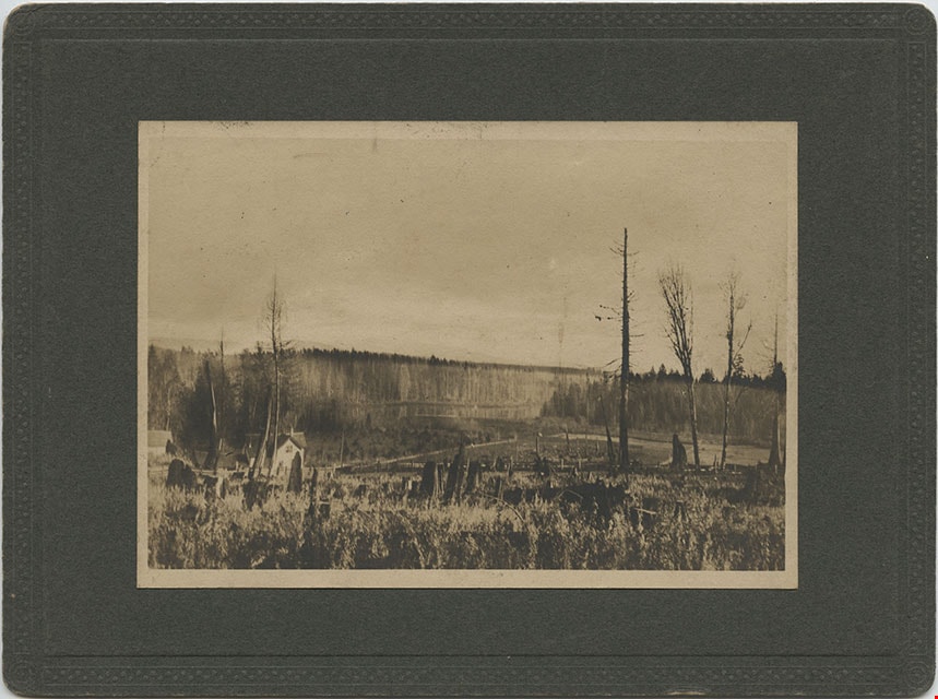
Haszard house
https://search.heritageburnaby.ca/link/museumdescription449
- Repository
- Burnaby Village Museum
- Date
- [190-](date of original), copied 1978
- Collection/Fonds
- Burnaby Village Museum Photograph collection
- Description Level
- Item
- Physical Description
- 1 photograph : b&w ; 20.2 x 25.2 cm print
- Scope and Content
- Photograph of a house in a clearing just on the outskirts of densely wooded area. There is a wooden fence around the property, and in front of the house is a dirt road. There are small piles of logs along the road side. An earlier catalogue record identifies this house as the Haszard house that was…
- Repository
- Burnaby Village Museum
- Collection/Fonds
- Burnaby Village Museum Photograph collection
- Description Level
- Item
- Physical Description
- 1 photograph : b&w ; 20.2 x 25.2 cm print
- Scope and Content
- Photograph of a house in a clearing just on the outskirts of densely wooded area. There is a wooden fence around the property, and in front of the house is a dirt road. There are small piles of logs along the road side. An earlier catalogue record identifies this house as the Haszard house that was located across the street from the property of the Sprott Farm. The photograph was taken from Douglas Road (later renamed in part Canada Way). It is also noted that the Sprott family lived in the Haszard house while their home, named "Dovecote" was being completed.
- Geographic Access
- Douglas Road
- Canada Way
- Accession Code
- HV978.1.3
- Access Restriction
- No restrictions
- Reproduction Restriction
- No known restrictions
- Date
- [190-](date of original), copied 1978
- Media Type
- Photograph
- Historic Neighbourhood
- Burnaby Lake (Historic Neighbourhood)
- Scan Resolution
- 600
- Scan Date
- 2023-07-25
- Notes
- Title based on contents of photograph
Images
, copied 1978 thumbnail](/media/hpo/_Data/_BVM_Images/1978/1978_0001_0003_001.jpg)