More like 'Book reading given by Pixie McGeachie January 10, 1973 - Track 6'
Narrow Results By
5190 Norfolk St
https://search.heritageburnaby.ca/link/archivedescription93756
- Repository
- City of Burnaby Archives
- Date
- April 14, 1992
- Collection/Fonds
- Grover, Elliott & Co. Ltd. fonds
- Description Level
- File
- Physical Description
- 25 photographs : col. negatives ; 35 mm
- Scope and Content
- Photographs of the exterior of the Royal Oak Baptist Church located at 5190 Norfolk Street.
- Repository
- City of Burnaby Archives
- Date
- April 14, 1992
- Collection/Fonds
- Grover, Elliott & Co. Ltd. fonds
- Physical Description
- 25 photographs : col. negatives ; 35 mm
- Description Level
- File
- Record No.
- 622-041
- Access Restriction
- No restrictions
- Reproduction Restriction
- No restrictions
- Accession Number
- 2017-39
- Scope and Content
- Photographs of the exterior of the Royal Oak Baptist Church located at 5190 Norfolk Street.
- Subjects
- Buildings - Religious - Churches
- Media Type
- Photograph
- Photographer
- Young, Richard
- Notes
- Transcribed title
- Title transcribed from envelope photographs were originally housed in
- File no. 92-167-B
- Geographic Access
- Norfolk Street
- Street Address
- 5190 Norfolk Street
- Planning Study Area
- Douglas-Gilpin Area
Danish Lutheran Church
https://search.heritageburnaby.ca/link/archivedescription36620
- Repository
- City of Burnaby Archives
- Date
- October 16, 1991
- Collection/Fonds
- Burnaby Historical Society fonds
- Description Level
- Item
- Physical Description
- 1 photograph : b&w ; 19 x 24 cm
- Scope and Content
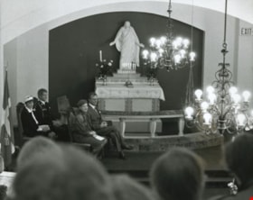
- Photograph of Her Royal Highness Queen Margrethe II and Prince Henrik of Denmark attending services at the Danish Lutheran Church in Burnaby.
- Repository
- City of Burnaby Archives
- Date
- October 16, 1991
- Collection/Fonds
- Burnaby Historical Society fonds
- Subseries
- Gavel Historical Society subseries
- Physical Description
- 1 photograph : b&w ; 19 x 24 cm
- Description Level
- Item
- Record No.
- 311-002
- Access Restriction
- No restrictions
- Reproduction Restriction
- Reproduce for fair dealing purposes only
- Accession Number
- BHS1994-03
- Scope and Content
- Photograph of Her Royal Highness Queen Margrethe II and Prince Henrik of Denmark attending services at the Danish Lutheran Church in Burnaby.
- Names
- Danish Evangelical Lutheran Church of Vancouver
- Margrethe II Queen of Denmark, 1940-
- Henrik, Prince, consort of Margarethe II, Queen of Denmark, 1934-
- Media Type
- Photograph
- Photographer
- Harrison, Jim
- Notes
- Title based on contents of photograph
- Geographic Access
- Kincaid Street
- Street Address
- 6010 Kincaid Street
- Historic Neighbourhood
- Burnaby Lake (Historic Neighbourhood)
- Planning Study Area
- Douglas-Gilpin Area
Images


Vancouver Heights Presbyterian Church
https://search.heritageburnaby.ca/link/archivedescription38238
- Repository
- City of Burnaby Archives
- Date
- 1998
- Collection/Fonds
- Burnaby Historical Society fonds
- Description Level
- Item
- Physical Description
- 1 photograph : col. ; 15 x 25 cm
- Scope and Content
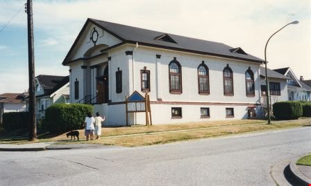
- Photograph of two unidentified women walking a dog past the Vancouver Heights Presbyterian Church.
- Repository
- City of Burnaby Archives
- Date
- 1998
- Collection/Fonds
- Burnaby Historical Society fonds
- Subseries
- Photographs subseries
- Physical Description
- 1 photograph : col. ; 15 x 25 cm
- Description Level
- Item
- Record No.
- 373-001
- Access Restriction
- No restrictions
- Reproduction Restriction
- Reproduce for fair dealing purposes only
- Accession Number
- BHS2007-04
- Scope and Content
- Photograph of two unidentified women walking a dog past the Vancouver Heights Presbyterian Church.
- Subjects
- Buildings - Religious - Churches
- Media Type
- Photograph
- Notes
- Title based on contents of photograph
- Geographic Access
- Esmond Avenue
- Street Address
- 140 Esmond Avenue
- Historic Neighbourhood
- Vancouver Heights (Historic Neighbourhood)
- Planning Study Area
- Burnaby Heights Area
Images

Interview with Sev Morin by Rod Fowler April 4, 1990 - Track 2
https://search.heritageburnaby.ca/link/oralhistory538
- Repository
- City of Burnaby Archives
- Date Range
- 1950-1990
- Length
- 00:06:16
- Summary
- This portion of the interview is about Sev Morin’s description of Burnaby’s growth and business development along Kingsway and Hastings, the Lake City Industrial Park, and the purchase of property in 1958 for the Heritage Park and Art Gallery.
- Repository
- City of Burnaby Archives
- Summary
- This portion of the interview is about Sev Morin’s description of Burnaby’s growth and business development along Kingsway and Hastings, the Lake City Industrial Park, and the purchase of property in 1958 for the Heritage Park and Art Gallery.
- Date Range
- 1950-1990
- Photo Info
- Sev Morin (left) of Severin's in Burnaby (formerly the Gai Paree) hosting a gala New Year's celebration, 1979. Item no. 480-712
- Length
- 00:06:16
- Subjects
- Buildings - Commercial
- Buildings - Civic
- Buildings - Industrial
- Buildings - Schools - Universities and Colleges
- Historic Neighbourhood
- Central Park (Historic Neighbourhood)
- Burnaby Lake (Historic Neighbourhood)
- Vancouver Heights (Historic Neighbourhood)
- Edmonds (Historic Neighbourhood)
- Planning Study Area
- Burnaby Heights Area
- Lake City Area
- Burnaby Mountain Area
- Kingsway-Beresford Area
- Douglas-Gilpin Area
- Interviewer
- Fowler, Rod
- Interview Date
- April 4, 1990
- Scope and Content
- Recording is of an interview with Severin "Sev" Morin, conducted by Rod Fowler. Sev Morin was one of eleven participants interviewed as part of the SFU/Burnaby Centennial Committee's oral history series titled, "Voices of Burnaby". The interview is mainly about Sev Morin’s banquet hall, restaurant and night club business on Kingsway, originally named the “Gai Paree Supper Club” (1947-1976) and later “Severin’s” (1976-1985) and “Diego’s” (1985-1994), its function as a Burnaby landmark, and the entertainment and political people he met through his business. He also describes his many volunteer activities in Burnaby, including member of the SFU Senate, Rotary Club, Variety Club and Telethon, fund raising for Burnaby Hospital, and tourism related groups, and his political work for the federal Liberal party. He talks about his parents’ origins, the lives of his brothers Rudy and Rene, and the family’s involvement in establishing the “Gai Paree”. He also shares his views about the business and cultural development of Burnaby. To view “Narrow By” terms for each track expand this description and see “Notes”.
- Biographical Notes
- Severin “Sev” Rene Morin was born September 21, 1927, in Bonneville, Alberta, to Rene Pierre Morin (1878-1963) and Anne Marie (nee Lachiver) Morin (1886-1956). Mr. and Mrs. R. P. Morin and their son Rene Francois (1905-1954) immigrated to Edmonton, Alberta, from France in 1913, where Rene Pierre Morin worked for the C.N.R. and a second son Adolphe “Rudy” Ferdinand (1922-1969) was born, followed by their third son Severin. In 1943, after R.P. Morin retired, the family moved to Burnaby to a house on Sperling Avenue. Sometime earlier the two older Morin brothers found work in Trail at the smelter and developed musical careers. In 1946/47 the Morin family purchased property on Kingsway and built a banquet hall, the “Gai Paree Supper Club”. Sev and Rudy Morin managed the club and Rene F. Morin moved to Burnaby to join them with his band. The supper club, with its live music and dance floor, became a popular meeting place and wedding venue, eventually expanding into a restaurant and nightclub in the 1970s. The “Gai Paree” was renamed “Severin’s” in 1976 and “Diego’s” in 1985, closing finally in 1994. Sev Morin’s business life included three record stores which he owned with his friend Jack Cullen. Through these businesses Sev Morin was well known in the entertainment and hospitality industry. He and his restaurant also hosted political and social events that made the restaurant a community landmark. Sev Morin contributed many volunteer hours to community and charitable organizations, including an appointment to the SFU Senate, fundraising for the Burnaby Hospital, Director of the Variety Club and Rotary Club, and consultant for a variety of tourism related ventures. He also was active in the federal Liberal Party. Sev Morin and his wife Pauline married in 1950 and had three children. Sev Morin died at age 86 on March 28, 2014.
- Total Tracks
- 10
- Total Length
- 00:56:44
- Interviewee Name
- Morin, Severin "Sev"
- Interviewer Bio
- Rod Fowler returned to university as a mature student in the 1980s after working about twenty years in the field of economics and computerization in business in England, Europe and Western Canada. He graduated with a BA from SFU in both History and Sociology in 1987, his MA degree in Geography in 1989, and his PhD in Cultural Geography at SFU. He taught courses in Geography, Sociology, History and Canadian Studies at several Lower Mainland colleges, before becoming a full time member of the Geography Department at Kwantlen University College.
- Collection/Fonds
- SFU/Burnaby Centennial Committee fonds
- Transcript Available
- Transcript available
- Media Type
- Sound Recording
- Web Notes
- Interviews were digitized in 2015 allowing them to be accessible on Heritage Burnaby. The digitization project was initiated by the Community Heritage Commission with support from City of Burnaby Council.
Images

Audio Tracks
Track two of interview with Sev Morin
Track two of interview with Sev Morin
https://search.heritageburnaby.ca/media/hpo/_Data/_Archives_Oral_Histories/_Unrestricted/MSS187-021/MSS187-021_Track%202.mp36900 [and] 7000 bk Hastings St. / 7000 blk Pandora St. 200 [and] 300 blks Cliff Ave Burnaby
https://search.heritageburnaby.ca/link/archivedescription94205
- Repository
- City of Burnaby Archives
- Date
- November 1993 - December 1993
- Collection/Fonds
- Grover, Elliott & Co. Ltd. fonds
- Description Level
- File
- Physical Description
- 96 photographs : col. negatives ; 35 mm
- Scope and Content
- Photographs of various residential and commercial streets in Burnaby.
- Repository
- City of Burnaby Archives
- Date
- November 1993 - December 1993
- Collection/Fonds
- Grover, Elliott & Co. Ltd. fonds
- Physical Description
- 96 photographs : col. negatives ; 35 mm
- Description Level
- File
- Record No.
- 622-080
- Access Restriction
- No restrictions
- Reproduction Restriction
- No restrictions
- Accession Number
- 2017-39
- Scope and Content
- Photographs of various residential and commercial streets in Burnaby.
- Subjects
- Geographic Features - Roads
- Buildings - Residential - Apartments
- Buildings - Residential - Houses
- Buildings - Commercial
- Media Type
- Photograph
- Notes
- Transcribed title
- Title transcribed from envelope photographs were originally housed in
- File no. 93-455-B
- Note on negative envelope housing photographs 622-080-1 : 622-080-74 reads: "93-11-26 / Inlet Dr/Hastings, Bby, / 93-455-B"
- Note on negative envelope housing photographs 622-080-75 : 622-080-96 reads: "93-12-01 / Comp's / 93-455"
- Photographer identified as "K.H."
- Geographic Access
- Hastings Street
- Cliff Avenue
- Pandora Street

7530 Buller Avenue
https://search.heritageburnaby.ca/link/archivedescription98686
- Repository
- City of Burnaby Archives
- Date
- 2022
- Collection/Fonds
- Disappearing Burnaby collection
- Description Level
- Item
- Physical Description
- 1 photograph (jpeg) : col.
- Scope and Content
- Photograph of the exterior of a two-storey house located at 7530 Buller Avenue. The photograph depicts the house at dusk; the house stands behind a wooden fence and is surrounded by trees. The house was constructed in 1924 and was formerly known as "Ryverbrae," the William & Esther Burdick Residenc…
- Repository
- City of Burnaby Archives
- Date
- 2022
- Collection/Fonds
- Disappearing Burnaby collection
- Physical Description
- 1 photograph (jpeg) : col.
- Description Level
- Item
- Record No.
- 634-033
- Access Restriction
- No restrictions
- Reproduction Restriction
- No restrictions
- Accession Number
- 2022-14
- Scope and Content
- Photograph of the exterior of a two-storey house located at 7530 Buller Avenue. The photograph depicts the house at dusk; the house stands behind a wooden fence and is surrounded by trees. The house was constructed in 1924 and was formerly known as "Ryverbrae," the William & Esther Burdick Residence.
- Media Type
- Photograph
- Photographer
- Cheung, Nakita
- Notes
- Title taken from the associated blog post
- Associated blog post: https://disappearingburnaby.wordpress.com/2022/06/30/william-esther-burdick-residence/
- Geographic Access
- Buller Avenue
- Street Address
- 7530 Buller Avenue
- Historic Neighbourhood
- Alta Vista (Historic Neighbourhood)
- Planning Study Area
- Clinton-Glenwood Area
Images

7641-7651 Royal Oak Ave
https://search.heritageburnaby.ca/link/archivedescription93769
- Repository
- City of Burnaby Archives
- Date
- July 30, 1992
- Collection/Fonds
- Grover, Elliott & Co. Ltd. fonds
- Description Level
- File
- Physical Description
- 25 photographs : col. negatives ; 35 mm
- Scope and Content
- Photographs of the commercial properties located between 7641 and 7651 Royal Oak Avenue. Stores visible in the photographs include: Buy Low Foods, Mega Movies, and Chevron service station.
- Repository
- City of Burnaby Archives
- Date
- July 30, 1992
- Collection/Fonds
- Grover, Elliott & Co. Ltd. fonds
- Physical Description
- 25 photographs : col. negatives ; 35 mm
- Description Level
- File
- Record No.
- 622-053
- Access Restriction
- No restrictions
- Reproduction Restriction
- No restrictions
- Accession Number
- 2017-39
- Scope and Content
- Photographs of the commercial properties located between 7641 and 7651 Royal Oak Avenue. Stores visible in the photographs include: Buy Low Foods, Mega Movies, and Chevron service station.
- Subjects
- Buildings - Commercial
- Buildings - Commercial - Service Stations
- Buildings - Commercial - Stores
- Geographic Features - Roads
- Media Type
- Photograph
- Photographer
- Young, Richard
- Notes
- Transcribed title
- Title transcribed from envelope photographs were originally housed in
- File no. 92-287-B
- Geographic Access
- Royal Oak Avenue
- Historic Neighbourhood
- Alta Vista (Historic Neighbourhood)
- Planning Study Area
- Maywood Area

Oh! Zhhu Sam
https://search.heritageburnaby.ca/link/archivedescription98681
- Repository
- City of Burnaby Archives
- Date
- 2022
- Collection/Fonds
- Disappearing Burnaby collection
- Description Level
- Item
- Physical Description
- 1 photograph (jpeg) : col.
- Scope and Content
- Photograph of the 7500 block of Edmonds Street at dusk. The photograph is taken from across Edmonds Street and depicts two commercial buildings: Oh! Zzhu Sam Korean Restaurant and the European Butcher Boy Delicatessen & Grocery. Oh! Zzhu Sam, located at 7506 Edmonds Street, was constructed in 1976.…
- Repository
- City of Burnaby Archives
- Date
- 2022
- Collection/Fonds
- Disappearing Burnaby collection
- Physical Description
- 1 photograph (jpeg) : col.
- Description Level
- Item
- Record No.
- 634-028
- Access Restriction
- No restrictions
- Reproduction Restriction
- No restrictions
- Accession Number
- 2022-14
- Scope and Content
- Photograph of the 7500 block of Edmonds Street at dusk. The photograph is taken from across Edmonds Street and depicts two commercial buildings: Oh! Zzhu Sam Korean Restaurant and the European Butcher Boy Delicatessen & Grocery. Oh! Zzhu Sam, located at 7506 Edmonds Street, was constructed in 1976. Residential houses border the restaurant and grocery store, and a bus shelter, municipal garbage can, and the restaurant's illuminated neon sign stand in front of the buildings.
- Subjects
- Buildings - Commercial
- Buildings - Commercial - Grocery Stores
- Buildings - Commercial - Restaurants
- Media Type
- Photograph
- Photographer
- Cheung, Nakita
- Notes
- Title taken from the associated blog post
- Associated blog post: https://disappearingburnaby.wordpress.com/2022/07/29/oh-zzhu-sam/
- Geographic Access
- Edmonds Street
- Street Address
- 7506 Edmonds Street
- Historic Neighbourhood
- Edmonds (Historic Neighbourhood)
- Planning Study Area
- Edmonds Area
Images


Trafalgar Market
https://search.heritageburnaby.ca/link/archivedescription98665
- Repository
- City of Burnaby Archives
- Date
- 2022
- Collection/Fonds
- Disappearing Burnaby collection
- Description Level
- Item
- Physical Description
- 1 photograph (jpeg) : col.
- Scope and Content
- Photograph of the intersection of Imperial Street and Sussex Avenue at night and in the rain. The photograph shows the Trafalgar Market grocery store (located at 4398 Imperial Street; the building was constructed in 1940) on the corner, with a large display of flowers for sale under the awning in f…
- Repository
- City of Burnaby Archives
- Date
- 2022
- Collection/Fonds
- Disappearing Burnaby collection
- Physical Description
- 1 photograph (jpeg) : col.
- Description Level
- Item
- Record No.
- 634-012
- Access Restriction
- No restrictions
- Reproduction Restriction
- No restrictions
- Accession Number
- 2022-14
- Scope and Content
- Photograph of the intersection of Imperial Street and Sussex Avenue at night and in the rain. The photograph shows the Trafalgar Market grocery store (located at 4398 Imperial Street; the building was constructed in 1940) on the corner, with a large display of flowers for sale under the awning in front of the store. The street and traffic lights are reflected in the puddles on the road, and cars and other businesses are visible along Imperial Street.
- Subjects
- Buildings - Commercial
- Buildings - Commercial - Grocery Stores
- Buildings - Commercial - Stores
- Geographic Features - Roads
- Media Type
- Photograph
- Photographer
- Cheung, Nakita
- Notes
- Title taken from the associated blog post
- Associated blog post: https://disappearingburnaby.wordpress.com/2022/02/20/imperial-manor-2/
- Geographic Access
- Imperial Street
- Sussex Avenue
- Street Address
- 4398 Imperial Street
- Historic Neighbourhood
- Central Park (Historic Neighbourhood)
- Planning Study Area
- Sussex-Nelson Area
Images

3355-3375 North Rd Burnaby
https://search.heritageburnaby.ca/link/archivedescription93891
- Repository
- City of Burnaby Archives
- Date
- June 1993
- Collection/Fonds
- Grover, Elliott & Co. Ltd. fonds
- Description Level
- File
- Physical Description
- 52 photographs : col. negatives ; 35 mm
- Scope and Content
- Photographs of the strip mall located at 3355-3375 North Road. Stores visible in the photographs include: CD Rentals and Laser Discs, Canadian 2-for-1 Pizza, Eyecrafters, North Road Dental Centre, Mike Fridays, and Penningtons.
- Repository
- City of Burnaby Archives
- Date
- June 1993
- Collection/Fonds
- Grover, Elliott & Co. Ltd. fonds
- Physical Description
- 52 photographs : col. negatives ; 35 mm
- Description Level
- File
- Record No.
- 622-074
- Access Restriction
- No restrictions
- Reproduction Restriction
- No restrictions
- Accession Number
- 2017-39
- Scope and Content
- Photographs of the strip mall located at 3355-3375 North Road. Stores visible in the photographs include: CD Rentals and Laser Discs, Canadian 2-for-1 Pizza, Eyecrafters, North Road Dental Centre, Mike Fridays, and Penningtons.
- Media Type
- Photograph
- Photographer
- Young, Richard
- Notes
- Transcribed title
- Title transcribed from envelope photographs were originally housed in
- File no. 93-273-B
- Geographic Access
- North Road
- Historic Neighbourhood
- Burquitlam (Historic Neighbourhood)
- Planning Study Area
- Lyndhurst Area
3735-3765 and 3815-3835 First Ave
https://search.heritageburnaby.ca/link/archivedescription93753
- Repository
- City of Burnaby Archives
- Date
- March 25, 1992
- Collection/Fonds
- Grover, Elliott & Co. Ltd. fonds
- Description Level
- File
- Physical Description
- 47 photographs : col. negatives ; 35 mm
- Scope and Content
- Photographs of the commercial-industrial buildings and loading bays located at 3735-3765 and 3815-3835 1st Avenue.
- Repository
- City of Burnaby Archives
- Date
- March 25, 1992
- Collection/Fonds
- Grover, Elliott & Co. Ltd. fonds
- Physical Description
- 47 photographs : col. negatives ; 35 mm
- Description Level
- File
- Record No.
- 622-038
- Access Restriction
- No restrictions
- Reproduction Restriction
- No restrictions
- Accession Number
- 2017-39
- Scope and Content
- Photographs of the commercial-industrial buildings and loading bays located at 3735-3765 and 3815-3835 1st Avenue.
- Subjects
- Buildings - Commercial
- Buildings - Industrial
- Transportation - Trucks
- Transportation - Automobiles
- Media Type
- Photograph
- Photographer
- Young, Richard
- Notes
- Transcribed title
- Title transcribed from envelope photographs were originally housed in
- File no. 92-139-B
- Geographic Access
- 1st Avenue
- Street Address
- 3735 1st Avenue
- 3815 1st Avenue
- Historic Neighbourhood
- Broadview (Historic Neighbourhood)
- Planning Study Area
- West Central Valley Area

3955 Moscrop Street
https://search.heritageburnaby.ca/link/archivedescription98654
- Repository
- City of Burnaby Archives
- Date
- 2021
- Collection/Fonds
- Disappearing Burnaby collection
- Description Level
- Item
- Physical Description
- 1 photograph (jpeg) : col.
- Scope and Content
- Photograph of the exterior of a house located at 3955 Moscrop Street. The house was constructed in 1954. The photograph depicts the house at night, with the house's porch light on, and a car is in the driveway in front of the house.
- Repository
- City of Burnaby Archives
- Date
- 2021
- Collection/Fonds
- Disappearing Burnaby collection
- Physical Description
- 1 photograph (jpeg) : col.
- Description Level
- Item
- Record No.
- 634-001
- Access Restriction
- No restrictions
- Reproduction Restriction
- No restrictions
- Accession Number
- 2022-14
- Scope and Content
- Photograph of the exterior of a house located at 3955 Moscrop Street. The house was constructed in 1954. The photograph depicts the house at night, with the house's porch light on, and a car is in the driveway in front of the house.
- Media Type
- Photograph
- Photographer
- Cheung, Nakita
- Notes
- Title taken from the associated blog post
- Associated blog post: https://disappearingburnaby.wordpress.com/2022/02/24/moscrop-house/
- Geographic Access
- Moscrop Street
- Street Address
- 3955 Moscrop Street
- Historic Neighbourhood
- Broadview (Historic Neighbourhood)
- Planning Study Area
- Cascade-Schou Area
Images

4775 Hastings St.
https://search.heritageburnaby.ca/link/archivedescription94340
- Repository
- City of Burnaby Archives
- Date
- October 1995
- Collection/Fonds
- Grover, Elliott & Co. Ltd. fonds
- Description Level
- File
- Physical Description
- 26 photographs : col. negatives ; 35 mm
- Scope and Content
- Photographs of a Pizza Hut restaurant located at 4775 Hastings Street and Honda and Toyota automotive dealerships located at 4780 Hastings Street.
- Repository
- City of Burnaby Archives
- Date
- October 1995
- Collection/Fonds
- Grover, Elliott & Co. Ltd. fonds
- Physical Description
- 26 photographs : col. negatives ; 35 mm
- Description Level
- File
- Record No.
- 622-125
- Access Restriction
- No restrictions
- Reproduction Restriction
- No restrictions
- Accession Number
- 2017-39
- Scope and Content
- Photographs of a Pizza Hut restaurant located at 4775 Hastings Street and Honda and Toyota automotive dealerships located at 4780 Hastings Street.
- Media Type
- Photograph
- Notes
- Transcribed title
- Title transcribed from envelope photographs were originally housed in
- File no. 95-247-B
- Geographic Access
- Hastings Street
- Street Address
- 4775 Hastings Street
- Historic Neighbourhood
- Capitol Hill (Historic Neighbourhood)
- Planning Study Area
- Capitol Hill Area
4780 Hastings Street
https://search.heritageburnaby.ca/link/archivedescription94341
- Repository
- City of Burnaby Archives
- Date
- July 1995
- Collection/Fonds
- Grover, Elliott & Co. Ltd. fonds
- Description Level
- File
- Physical Description
- 50 photographs : col. negatives ; 35 mm
- Scope and Content
- Photographs of the Honda and Toyota automotive dealerships located at 4780 Hastings Street. File also contains photographs of businesses located along Hastings Street, including: Liquidation World, Young Buildings Supplies and Hardware, Big-O Tires, Full Gospel Assembly Vancouver, Salza Mexican Pr…
- Repository
- City of Burnaby Archives
- Date
- July 1995
- Collection/Fonds
- Grover, Elliott & Co. Ltd. fonds
- Physical Description
- 50 photographs : col. negatives ; 35 mm
- Description Level
- File
- Record No.
- 622-126
- Access Restriction
- No restrictions
- Reproduction Restriction
- No restrictions
- Accession Number
- 2017-39
- Scope and Content
- Photographs of the Honda and Toyota automotive dealerships located at 4780 Hastings Street. File also contains photographs of businesses located along Hastings Street, including: Liquidation World, Young Buildings Supplies and Hardware, Big-O Tires, Full Gospel Assembly Vancouver, Salza Mexican Products, and Pro-Feel Hair Studio.
- Media Type
- Photograph
- Notes
- Transcribed title
- Title transcribed from envelope photographs were originally housed in
- File no. 95-248-B
- Photographer identified as "K.H."
- Geographic Access
- Hastings Street
- Street Address
- 4780 Hastings Street
- Historic Neighbourhood
- Capitol Hill (Historic Neighbourhood)
- Planning Study Area
- Capitol Hill Area
4806 Hastings Street
https://search.heritageburnaby.ca/link/archivedescription94342
- Repository
- City of Burnaby Archives
- Date
- July 1995
- Collection/Fonds
- Grover, Elliott & Co. Ltd. fonds
- Description Level
- File
- Physical Description
- 25 photographs : col. negatives ; 35 mm
- Scope and Content
- Photographs of the 4700 and 4800 blocks of Hastings Street. Businesses visible in the photographs include Pizza Hut and Jan's Grocery.
- Repository
- City of Burnaby Archives
- Date
- July 1995
- Collection/Fonds
- Grover, Elliott & Co. Ltd. fonds
- Physical Description
- 25 photographs : col. negatives ; 35 mm
- Description Level
- File
- Record No.
- 622-127
- Access Restriction
- No restrictions
- Reproduction Restriction
- No restrictions
- Accession Number
- 2017-39
- Scope and Content
- Photographs of the 4700 and 4800 blocks of Hastings Street. Businesses visible in the photographs include Pizza Hut and Jan's Grocery.
- Media Type
- Photograph
- Notes
- Transcribed title
- Title transcribed from envelope photographs were originally housed in
- File no. 95-249-B
- Photographer identified as "K.H."
- Geographic Access
- Hastings Street
- Historic Neighbourhood
- Capitol Hill (Historic Neighbourhood)
- Planning Study Area
- Capitol Hill Area

5130 Irving Street
https://search.heritageburnaby.ca/link/archivedescription98671
- Repository
- City of Burnaby Archives
- Date
- 2022
- Collection/Fonds
- Disappearing Burnaby collection
- Description Level
- Item
- Physical Description
- 1 photograph (jpeg) : col.
- Scope and Content
- Photograph of the front steps and the entrance of a three-storey apartment building located at 5130 Irving Street. The photograph depicts the building at night, with the lobby and some of the apartments' windows illuminated from inside. The building was constructed in 1971.
- Repository
- City of Burnaby Archives
- Date
- 2022
- Collection/Fonds
- Disappearing Burnaby collection
- Physical Description
- 1 photograph (jpeg) : col.
- Description Level
- Item
- Record No.
- 634-018
- Access Restriction
- No restrictions
- Reproduction Restriction
- No restrictions
- Accession Number
- 2022-14
- Scope and Content
- Photograph of the front steps and the entrance of a three-storey apartment building located at 5130 Irving Street. The photograph depicts the building at night, with the lobby and some of the apartments' windows illuminated from inside. The building was constructed in 1971.
- Media Type
- Photograph
- Photographer
- Cheung, Nakita
- Notes
- Title taken from the associated blog post
- Associated blog post: https://disappearingburnaby.wordpress.com/2022/05/04/e-just-e/
- Geographic Access
- Irving Street
- Street Address
- 5130 Irving Street
- Historic Neighbourhood
- Central Park (Historic Neighbourhood)
- Planning Study Area
- Marlborough Area
Images


5130 Irving Street lobby
https://search.heritageburnaby.ca/link/archivedescription98672
- Repository
- City of Burnaby Archives
- Date
- 2022
- Collection/Fonds
- Disappearing Burnaby collection
- Description Level
- Item
- Physical Description
- 1 photograph (jpeg) : col.
- Scope and Content
- Photograph of the entrance of an apartment building located at 5130 Irving Street. The building was constructed in 1971. The photograph depicts the entrance and the lobby from the exterior at night. The lobby is illuminated and a crest featuring an "E" is on the entrance window.
- Repository
- City of Burnaby Archives
- Date
- 2022
- Collection/Fonds
- Disappearing Burnaby collection
- Physical Description
- 1 photograph (jpeg) : col.
- Description Level
- Item
- Record No.
- 634-019
- Access Restriction
- No restrictions
- Reproduction Restriction
- No restrictions
- Accession Number
- 2022-14
- Scope and Content
- Photograph of the entrance of an apartment building located at 5130 Irving Street. The building was constructed in 1971. The photograph depicts the entrance and the lobby from the exterior at night. The lobby is illuminated and a crest featuring an "E" is on the entrance window.
- Media Type
- Photograph
- Photographer
- Cheung, Nakita
- Notes
- Title taken from the associated blog post
- Associated blog post: https://disappearingburnaby.wordpress.com/2022/05/04/e-just-e/
- Geographic Access
- Irving Street
- Street Address
- 5130 Irving Street
- Historic Neighbourhood
- Central Park (Historic Neighbourhood)
- Planning Study Area
- Marlborough Area
Images

5820 S.E. Marine Dr. Burnaby
https://search.heritageburnaby.ca/link/archivedescription94301
- Repository
- City of Burnaby Archives
- Date
- February 1994
- Collection/Fonds
- Grover, Elliott & Co. Ltd. fonds
- Description Level
- File
- Physical Description
- 19 photographs : col. negatives ; 35 mm
- Scope and Content
- Photographs of the commercial property located at 5820 Marine Drive and along the 5800 block of Marine Drive.
- Repository
- City of Burnaby Archives
- Date
- February 1994
- Collection/Fonds
- Grover, Elliott & Co. Ltd. fonds
- Physical Description
- 19 photographs : col. negatives ; 35 mm
- Description Level
- File
- Record No.
- 622-086
- Access Restriction
- No restrictions
- Reproduction Restriction
- No restrictions
- Accession Number
- 2017-39
- Scope and Content
- Photographs of the commercial property located at 5820 Marine Drive and along the 5800 block of Marine Drive.
- Media Type
- Photograph
- Notes
- Transcribed title
- Title transcribed from envelope photographs were originally housed in
- File no. 94-015-B
- Photographer identified as "K.H."
- Geographic Access
- Marine Drive
- Street Address
- 5820 Marine Drive
- Historic Neighbourhood
- Fraser Arm (Historic Neighbourhood)
- Planning Study Area
- Big Bend Area

5990 Irmin Street
https://search.heritageburnaby.ca/link/archivedescription98685
- Repository
- City of Burnaby Archives
- Date
- 2022
- Collection/Fonds
- Disappearing Burnaby collection
- Description Level
- Item
- Physical Description
- 1 photograph (jpeg) : col.
- Scope and Content
- Photograph of a multi-storey house located at 5990 Irmin Street. The photograph depicts of the exterior of the house at dusk; a light is on in one of the house's rooms and a vehicle is parked in the house's driveway next to a portable garage. A "For Sale" sign on the edge of the property reads: "Fu…
- Repository
- City of Burnaby Archives
- Date
- 2022
- Collection/Fonds
- Disappearing Burnaby collection
- Physical Description
- 1 photograph (jpeg) : col.
- Description Level
- Item
- Record No.
- 634-032
- Access Restriction
- No restrictions
- Reproduction Restriction
- No restrictions
- Accession Number
- 2022-14
- Scope and Content
- Photograph of a multi-storey house located at 5990 Irmin Street. The photograph depicts of the exterior of the house at dusk; a light is on in one of the house's rooms and a vehicle is parked in the house's driveway next to a portable garage. A "For Sale" sign on the edge of the property reads: "Future Development Land." Another house is visible in the background. The house was constructed in 1923 and is nearby to 7530 Buller Avenue.
- Media Type
- Photograph
- Photographer
- Cheung, Nakita
- Notes
- Title taken from the associated blog post
- Associated blog post: https://disappearingburnaby.wordpress.com/2022/06/30/william-esther-burdick-residence/
- Geographic Access
- Irmin Street
- Street Address
- 5990 Irmin Street
- Historic Neighbourhood
- Alta Vista (Historic Neighbourhood)
- Planning Study Area
- Clinton-Glenwood Area
Images


6280 Marlborough Avenue
https://search.heritageburnaby.ca/link/archivedescription98673
- Repository
- City of Burnaby Archives
- Date
- 2022
- Collection/Fonds
- Disappearing Burnaby collection
- Description Level
- Item
- Physical Description
- 1 photograph (jpeg) : col.
- Scope and Content
- Photograph of the front steps and entry to a three-storey apartment building, located at 6280 Marlborough Avenue. The photograph depicts the building at night and shows the brick building's details, including its lion statues and busts along the stair railings and the curved arches in front of the …
- Repository
- City of Burnaby Archives
- Date
- 2022
- Collection/Fonds
- Disappearing Burnaby collection
- Physical Description
- 1 photograph (jpeg) : col.
- Description Level
- Item
- Record No.
- 634-020
- Access Restriction
- No restrictions
- Reproduction Restriction
- No restrictions
- Accession Number
- 2022-14
- Scope and Content
- Photograph of the front steps and entry to a three-storey apartment building, located at 6280 Marlborough Avenue. The photograph depicts the building at night and shows the brick building's details, including its lion statues and busts along the stair railings and the curved arches in front of the front windows and door. The building was constructed in 1973.
- Media Type
- Photograph
- Photographer
- Cheung, Nakita
- Notes
- Title taken from the associated blog post
- Associated blog post: https://disappearingburnaby.wordpress.com/2022/05/12/marlborough-ave/
- Geographic Access
- Marlborough Avenue
- Street Address
- 6280 Marlborough Avenue
- Historic Neighbourhood
- Central Park (Historic Neighbourhood)
- Planning Study Area
- Marlborough Area
Images
