More like 'Moving the Love farmhouse'
Narrow Results By
Decade
- 2020s 96
- 2010s 43
- 2000s 481
- 1990s 398
- 1980s 404
- 1970s 943
- 1960s 280
- 1950s
- 1940s 420
- 1930s 349
- 1920s 373
- 1910s 445
- 1900s 173
- 1890s 23
- 1880s 49
- 1870s 3
- 1860s 1
- 1850s 1
- 1840s 1
- 1830s 1
- 1820s 1
- 1810s 1
- 1800s 1
- 1790s 1
- 1780s 1
- 1770s 1
- 1760s 1
- 1750s 1
- 1740s 1
- 1730s 1
- 1720s 1
- 1710s 1
- 1700s 1
- 1690s 1
- 1680s 1
- 1670s 1
- 1660s 1
- 1650s 1
- 1640s 1
- 1630s 1
- 1620s 1
- 1610s 1
- 1600s 1
Subject
- Advertising Medium 2
- Advertising Medium - Signs and Signboards 7
- Aerial Photographs 8
- Agriculture - Farms 17
- Agriculture - Fruit and Berries 1
- Animals - Horses 1
- Arts - Paintings 1
- Buildings 2
- Buildings - Agricultural 1
- Buildings - Agricultural - Barns 6
- Buildings - Agricultural - Greenhouses 5
- Buildings - Agricultural - Nurseries 1
![House on Hardwick Street, [1959] (date of original), digitally copied 2012 thumbnail](/media/hpo/_Data/_Archives_Images/_Unrestricted/540/549-031.jpg?width=280)
House on Hardwick Street
https://search.heritageburnaby.ca/link/archivedescription76911
- Repository
- City of Burnaby Archives
- Date
- [1959] (date of original), digitally copied 2012
- Collection/Fonds
- Community Heritage Commission Special Projects fonds
- Description Level
- Item
- Physical Description
- 1 photograph (jpeg) : col. ; 300ppi
- Scope and Content
- Photograph of Tony Fabian's house on Hardwick Street. An unidentified woman and a German shepherd dog are visible standing in the front yard.
- Repository
- City of Burnaby Archives
- Date
- [1959] (date of original), digitally copied 2012
- Collection/Fonds
- Community Heritage Commission Special Projects fonds
- Physical Description
- 1 photograph (jpeg) : col. ; 300ppi
- Description Level
- Item
- Record No.
- 549-031
- Access Restriction
- No restrictions
- Reproduction Restriction
- Reproduce for fair dealing purposes only
- Accession Number
- 2012-30
- Scope and Content
- Photograph of Tony Fabian's house on Hardwick Street. An unidentified woman and a German shepherd dog are visible standing in the front yard.
- Subjects
- Buildings - Residential - Houses
- Media Type
- Photograph
- Notes
- Title based on contents of photograph
- Geographic Access
- Hardwick Street
- Planning Study Area
- Douglas-Gilpin Area
Images
![House on Hardwick Street, [1959] (date of original), digitally copied 2012 thumbnail](/media/hpo/_Data/_Archives_Images/_Unrestricted/540/549-031.jpg)

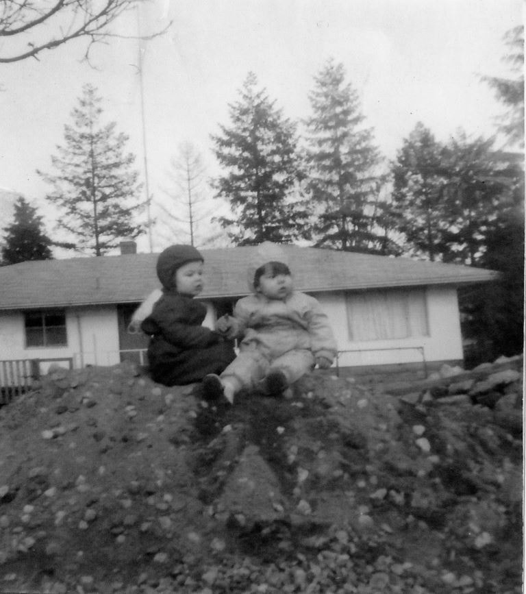
Looking east from 5493 Dominion Street
https://search.heritageburnaby.ca/link/archivedescription91841
- Repository
- City of Burnaby Archives
- Date
- 1959
- Collection/Fonds
- Small family fonds
- Description Level
- Item
- Physical Description
- 1 photograph : b&w copy print ; 11.5 cm x 10 cm
- Scope and Content
- Photograph of the Brocklebank children Brian and Pam, sitting on a dirt pile in front their single-storey house. The Hardys sold the north half of their property at 3071 Douglas Road to the Brocklebanks who built the house in 1957. The photograph was taken from 5493 (previously 3107) Dominion Str…
- Repository
- City of Burnaby Archives
- Date
- 1959
- Collection/Fonds
- Small family fonds
- Physical Description
- 1 photograph : b&w copy print ; 11.5 cm x 10 cm
- Description Level
- Item
- Record No.
- 620-022
- Access Restriction
- No restrictions
- Reproduction Restriction
- No reproduction permitted
- Accession Number
- 2017-01
- Scope and Content
- Photograph of the Brocklebank children Brian and Pam, sitting on a dirt pile in front their single-storey house. The Hardys sold the north half of their property at 3071 Douglas Road to the Brocklebanks who built the house in 1957. The photograph was taken from 5493 (previously 3107) Dominion Street, looking east.
- Media Type
- Photograph
- Notes
- Transcribed title
- Title transcribed from donor's notes
- Note in blue ink on verso of photograph reads: "P.22"
- Note in blue ink on verso of photograph reads: "Courtesy of [name]"
- Street Address
- 3071 Douglas Road
- Historic Neighbourhood
- Burnaby Lake (Historic Neighbourhood)
- Planning Study Area
- Ardingley-Sprott Area
Images
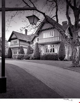
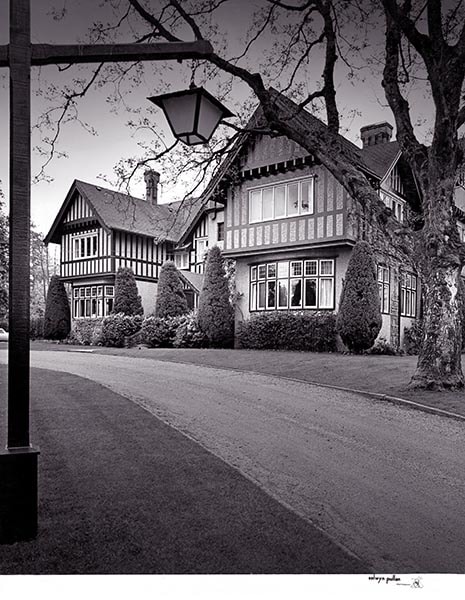
C. B. Riley Home - Western Homes & Living photographs
https://search.heritageburnaby.ca/link/archivedescription95583
- Repository
- City of Burnaby Archives
- Date
- March 1959
- Collection/Fonds
- City of Burnaby Archives photograph collection
- Description Level
- File
- Physical Description
- 2 photographs (tiff) and 3 p. of textual records (tiff, psd)
- Scope and Content
- File consists of a digitized copy of the article "Where Space is No Problem," from the March 1959 issue of Western Homes & Living Magazine, and related photographs. The article reports on the C. B. Riley home (formerly the F.J. Hart Estate "Avalon"; now Hart House) and includes floor plans and phot…
- Repository
- City of Burnaby Archives
- Date
- March 1959
- Collection/Fonds
- City of Burnaby Archives photograph collection
- Physical Description
- 2 photographs (tiff) and 3 p. of textual records (tiff, psd)
- Description Level
- File
- Record No.
- 625-001
- Access Restriction
- No restrictions
- Reproduction Restriction
- Reproduce for fair dealing purposes only
- Accession Number
- 2021-10
- Scope and Content
- File consists of a digitized copy of the article "Where Space is No Problem," from the March 1959 issue of Western Homes & Living Magazine, and related photographs. The article reports on the C. B. Riley home (formerly the F.J. Hart Estate "Avalon"; now Hart House) and includes floor plans and photographs of the house taken by Selwyn Pullan. Photographs in this file, which are also printed in the article, depict the kitchen and the exterior of the home.
- Subjects
- Buildings - Heritage
- Media Type
- Photograph
- Textual Record
- Photographer
- Pullan, Selwyn
- Notes
- Title based on content of file
- Street Address
- 6664 Deer Lake Avenue
- Historic Neighbourhood
- Burnaby Lake (Historic Neighbourhood)
- Planning Study Area
- Morley-Buckingham Area
Images
![Municipal Hall, [1959] thumbnail](/media/hpo/_Data/_Archives_Images/_Unrestricted/001/071-001.jpg?width=280)
Municipal Hall
https://search.heritageburnaby.ca/link/archivedescription34636
- Repository
- City of Burnaby Archives
- Date
- [1959]
- Collection/Fonds
- Burnaby Historical Society fonds
- Description Level
- Item
- Physical Description
- 1 photograph : b&w ; 20.2 x 25.4 cm
- Scope and Content
- Photograph of the exterior of Burnaby Municipal Hall at 4949 Canada Way.
- Repository
- City of Burnaby Archives
- Date
- [1959]
- Collection/Fonds
- Burnaby Historical Society fonds
- Subseries
- Photographs subseries
- Physical Description
- 1 photograph : b&w ; 20.2 x 25.4 cm
- Description Level
- Item
- Record No.
- 071-001
- Access Restriction
- No restrictions
- Reproduction Restriction
- Reproduce for fair dealing purposes only
- Accession Number
- BHS2007-04
- Scope and Content
- Photograph of the exterior of Burnaby Municipal Hall at 4949 Canada Way.
- Subjects
- Buildings - Civic - City Halls
- Names
- Burnaby City Hall
- Media Type
- Photograph
- Notes
- Title based on contents of photograph
- Geographic Access
- Canada Way
- Street Address
- 4949 Canada Way
- Historic Neighbourhood
- Burnaby Lake (Historic Neighbourhood)
- Planning Study Area
- Douglas-Gilpin Area
Images
![Municipal Hall, [1959] thumbnail](/media/hpo/_Data/_Archives_Images/_Unrestricted/001/071-001.jpg)
![Brantford Coach and Body Ltd., [1959] thumbnail](/media/hpo/_Data/_Archives_Images/_Unrestricted/001/076-001.jpg?width=280)
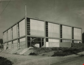
Brantford Coach and Body Ltd.
https://search.heritageburnaby.ca/link/archivedescription34642
- Repository
- City of Burnaby Archives
- Date
- [1959]
- Collection/Fonds
- Burnaby Historical Society fonds
- Description Level
- Item
- Physical Description
- 1 photograph : b&w ; 20.5 x 25.7 cm
- Scope and Content
- Photograph of the exterior of Brantford Coach and Body Ltd. at 6055 Gilmore Avenue. Signs on the building show the business name and also read, "Sales" and "Service."
- Repository
- City of Burnaby Archives
- Date
- [1959]
- Collection/Fonds
- Burnaby Historical Society fonds
- Subseries
- Photographs subseries
- Physical Description
- 1 photograph : b&w ; 20.5 x 25.7 cm
- Description Level
- Item
- Record No.
- 076-001
- Access Restriction
- No restrictions
- Reproduction Restriction
- Reproduce for fair dealing purposes only
- Accession Number
- BHS2007-04
- Scope and Content
- Photograph of the exterior of Brantford Coach and Body Ltd. at 6055 Gilmore Avenue. Signs on the building show the business name and also read, "Sales" and "Service."
- Subjects
- Buildings - Industrial
- Media Type
- Photograph
- Notes
- Title based on contents of photograph
- Geographic Access
- Gilmore Avenue
- Street Address
- 6055 Gilmore Avenue
Images
![Brantford Coach and Body Ltd., [1959] thumbnail](/media/hpo/_Data/_Archives_Images/_Unrestricted/001/076-001.jpg)
Glenburn Telephone Exchange
https://search.heritageburnaby.ca/link/archivedescription34706
- Repository
- City of Burnaby Archives
- Date
- 1959
- Collection/Fonds
- Burnaby Historical Society fonds
- Description Level
- Item
- Physical Description
- 1 photograph : b&w ; 20.2 x 25.7 cm
- Scope and Content
- Photograph of the exterior of the Glenburn Telephone Exchange at Delta Avenue and Parker Street. A typed description on the back of the photograph reads, "Glenburn Automatic Exchange at Delta and Parker streets. To be cutover in March, 1959. / B.C. Telephone Company."
- Repository
- City of Burnaby Archives
- Date
- 1959
- Collection/Fonds
- Burnaby Historical Society fonds
- Subseries
- Photographs subseries
- Physical Description
- 1 photograph : b&w ; 20.2 x 25.7 cm
- Description Level
- Item
- Record No.
- 111-001
- Access Restriction
- No restrictions
- Reproduction Restriction
- Reproduce for fair dealing purposes only
- Accession Number
- BHS2007-04
- Scope and Content
- Photograph of the exterior of the Glenburn Telephone Exchange at Delta Avenue and Parker Street. A typed description on the back of the photograph reads, "Glenburn Automatic Exchange at Delta and Parker streets. To be cutover in March, 1959. / B.C. Telephone Company."
- Subjects
- Buildings - Commercial
- Media Type
- Photograph
- Photographer
- Graphic Industries Limited
- Notes
- Title based on contents of photograph
- Caption at bottom of photograph reads, "British Columbia Telephone Company"
- Stamp on back of photograph reads, "Photo by Graphic Industries Ltd. / File No. 3841-2 / Vancouver, Canada Mutual 1-4174"
- Geographic Access
- Delta Avenue
- Parker Street
- Planning Study Area
- Brentwood Area
Images
![Boundary Road and Kingsway, [1959] thumbnail](/media/Hpo/_Data/_Archives_Images/_Unrestricted/001/113-001.jpg?width=280)
Boundary Road and Kingsway
https://search.heritageburnaby.ca/link/archivedescription34709
- Repository
- City of Burnaby Archives
- Date
- [1959]
- Collection/Fonds
- Burnaby Historical Society fonds
- Description Level
- Item
- Physical Description
- 1 photograph : b&w ; 16.0 x 25.3 cm
- Scope and Content
- Photograph of buildings at Boundary Road and Kingsway, southwest corner. A typed description on the back of the photograph reads, "The new Hemlock (automatic) and old Dexter (manual) exchanges. / B.C. Telephone Company."
- Repository
- City of Burnaby Archives
- Date
- [1959]
- Collection/Fonds
- Burnaby Historical Society fonds
- Subseries
- Photographs subseries
- Physical Description
- 1 photograph : b&w ; 16.0 x 25.3 cm
- Description Level
- Item
- Record No.
- 113-001
- Access Restriction
- No restrictions
- Reproduction Restriction
- Reproduce for fair dealing purposes only
- Accession Number
- BHS2007-04
- Scope and Content
- Photograph of buildings at Boundary Road and Kingsway, southwest corner. A typed description on the back of the photograph reads, "The new Hemlock (automatic) and old Dexter (manual) exchanges. / B.C. Telephone Company."
- Media Type
- Photograph
- Photographer
- Williams Brothers Photographers Limited
- Notes
- Title based on contents of photograph
- Stamp on back of photograph reads, "Williams Bros. Photographers Ltd. / 413 Granville St. Vancouver 2, B.C. / Phone Tatlow 8588"
- Geographic Access
- Boundary Road
- Kingsway
- Historic Neighbourhood
- Central Park (Historic Neighbourhood)
- Planning Study Area
- Garden Village Area
Images
![Boundary Road and Kingsway, [1959] thumbnail](/media/Hpo/_Data/_Archives_Images/_Unrestricted/001/113-001.jpg)

Extension of McPherson Park School
https://search.heritageburnaby.ca/link/archivedescription36489
- Repository
- City of Burnaby Archives
- Date
- September 1959
- Collection/Fonds
- Burnaby Historical Society fonds
- Description Level
- Item
- Physical Description
- 1 photograph : b&w ; 8.5 x 12.5 cm print
- Scope and Content
- Photograph of the A.J. Keel house with excavation for the extension of the McPherson Park School.
- Repository
- City of Burnaby Archives
- Date
- September 1959
- Collection/Fonds
- Burnaby Historical Society fonds
- Subseries
- Keel family subseries
- Physical Description
- 1 photograph : b&w ; 8.5 x 12.5 cm print
- Description Level
- Item
- Record No.
- 279-002
- Access Restriction
- No restrictions
- Reproduction Restriction
- Reproduce for fair dealing purposes only
- Accession Number
- BHS1992-09
- Scope and Content
- Photograph of the A.J. Keel house with excavation for the extension of the McPherson Park School.
- Names
- McPherson Park School
- Media Type
- Photograph
- Notes
- Title based on contents of photograph
- Geographic Access
- Rumble Street
- Historic Neighbourhood
- Alta-Vista (Historic Neighbourhood)
- Planning Study Area
- Clinton-Glenwood Area
Images


Extension of McPherson Park School
https://search.heritageburnaby.ca/link/archivedescription36490
- Repository
- City of Burnaby Archives
- Date
- September 1959
- Collection/Fonds
- Burnaby Historical Society fonds
- Description Level
- Item
- Physical Description
- 1 photograph : b&w ; 8.5 x 12.5 cm print
- Scope and Content
- Photograph of the A.J. Keel house with a close-up of the excavation for the extension of McPherson Park School.
- Repository
- City of Burnaby Archives
- Date
- September 1959
- Collection/Fonds
- Burnaby Historical Society fonds
- Subseries
- Keel family subseries
- Physical Description
- 1 photograph : b&w ; 8.5 x 12.5 cm print
- Description Level
- Item
- Record No.
- 279-003
- Access Restriction
- No restrictions
- Reproduction Restriction
- Reproduce for fair dealing purposes only
- Accession Number
- BHS1992-09
- Scope and Content
- Photograph of the A.J. Keel house with a close-up of the excavation for the extension of McPherson Park School.
- Names
- McPherson Park School
- Media Type
- Photograph
- Notes
- Title based on contents of photograph
- Geographic Access
- Rumble Street
- Historic Neighbourhood
- Alta-Vista (Historic Neighbourhood)
- Planning Study Area
- Clinton-Glenwood Area
Images


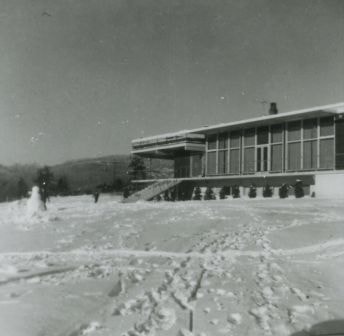
Restaurant on Burnaby Mountain
https://search.heritageburnaby.ca/link/archivedescription37442
- Repository
- City of Burnaby Archives
- Date
- 1959 (date of original), copied 1991
- Collection/Fonds
- Burnaby Historical Society fonds
- Description Level
- Item
- Physical Description
- 1 photograph : b&w ; 3.8 x 3.7 cm print on contact sheet 20.2 x 25.4 cm
- Scope and Content
- Photograph of a restaurant on Burnaby Mountain after a snowfall. A snowman is visible on the left side of the photograph.
- Repository
- City of Burnaby Archives
- Date
- 1959 (date of original), copied 1991
- Collection/Fonds
- Burnaby Historical Society fonds
- Subseries
- Burnaby Image Bank subseries
- Physical Description
- 1 photograph : b&w ; 3.8 x 3.7 cm print on contact sheet 20.2 x 25.4 cm
- Description Level
- Item
- Record No.
- 370-030
- Access Restriction
- No restrictions
- Reproduction Restriction
- No restrictions
- Accession Number
- BHS1999-03
- Scope and Content
- Photograph of a restaurant on Burnaby Mountain after a snowfall. A snowman is visible on the left side of the photograph.
- Subjects
- Buildings - Commercial - Restaurants
- Media Type
- Photograph
- Notes
- Title based on contents of photograph
- 1 b&w copy negative accompanying
- Geographic Access
- Burnaby Mountain Conservation Area
- Planning Study Area
- Burnaby Mountain Area
Images
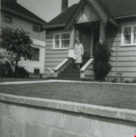
Residential area
https://search.heritageburnaby.ca/link/archivedescription38183
- Repository
- City of Burnaby Archives
- Date
- June 1959 (date of original), copied 1991
- Collection/Fonds
- Burnaby Historical Society fonds
- Description Level
- Item
- Physical Description
- 1 photograph : b&w ; 3.6 x 3.5 cm print on contact sheet 20.6 x 26.5 cm
- Scope and Content
- Photograph of a woman standing on the steps of a house in a " fancy residential area", possibly Vancouver Heights.
- Repository
- City of Burnaby Archives
- Date
- June 1959 (date of original), copied 1991
- Collection/Fonds
- Burnaby Historical Society fonds
- Subseries
- Burnaby Image Bank subseries
- Physical Description
- 1 photograph : b&w ; 3.6 x 3.5 cm print on contact sheet 20.6 x 26.5 cm
- Description Level
- Item
- Record No.
- 370-770
- Access Restriction
- No restrictions
- Reproduction Restriction
- No restrictions
- Accession Number
- BHS1999-03
- Scope and Content
- Photograph of a woman standing on the steps of a house in a " fancy residential area", possibly Vancouver Heights.
- Subjects
- Buildings - Residential - Houses
- Media Type
- Photograph
- Notes
- Title based on contents of photograph
- 1 b&w copy negative accompanying
- Negative has a pink cast
- Date at bottom of photograph reads, "Jun 59"
- Historic Neighbourhood
- Vancouver Heights (Historic Neighbourhood)
Images

![Nichols Chemical Co. Ltd. - Drawing No. 50785, [1959] thumbnail](/media/hpo/_Data/_BVM_Technical_Drawings/1998_0023_0014_002.jpg?width=280)
Nichols Chemical Co. Ltd. - Drawing No. 50785
https://search.heritageburnaby.ca/link/museumdescription11392
- Repository
- Burnaby Village Museum
- Date
- [1959]
- Collection/Fonds
- Nichols Chemical Company fonds
- Description Level
- Item
- Physical Description
- 1 technical drawing : blueline print ; 87.5 x 111 cm
- Scope and Content
- Item consists of technical drawing identified as No. 50785 with handwritten annotation reading "W.O.M. - 8560". Property Exclusively of General Chemical Company.
- Repository
- Burnaby Village Museum
- Collection/Fonds
- Nichols Chemical Company fonds
- Description Level
- Item
- Physical Description
- 1 technical drawing : blueline print ; 87.5 x 111 cm
- Material Details
- Scale 1:.25
- Scope and Content
- Item consists of technical drawing identified as No. 50785 with handwritten annotation reading "W.O.M. - 8560". Property Exclusively of General Chemical Company.
- Subjects
- Buildings - Industrial - Factories
- Responsibility
- General Chemical Company
- Geographic Access
- Barnet Road
- Street Address
- 8655 Barnet Road
- Accession Code
- BV998.23.14
- Access Restriction
- No restrictions
- Reproduction Restriction
- No known restrictions
- Date
- [1959]
- Media Type
- Technical Drawing
- Historic Neighbourhood
- Barnet (Historic Neighbourhood)
- Planning Study Area
- Burnaby Mountain Area
- Scan Resolution
- 300
- Scan Date
- 2022-05-10
- Notes
- Title based on contents of item
- Stamp on verso reads: "R.L. Johnston"
- "Scale 1/4" = 1'
- Date stampled "Oct. 19 1959"
- Annotation next to date stamp reads: "Dwg Rec'd 10-24-59"
- Stamp at bottom reads: "Property of / General Chemical Division / Allied Chemical & Dye Corporation"
Images
![Nichols Chemical Co. Ltd. - Drawing No. 50785, [1959] thumbnail](/media/hpo/_Data/_BVM_Technical_Drawings/1998_0023_0014_002.jpg)
Proposed building addition for R. Raymer
https://search.heritageburnaby.ca/link/museumdescription15547
- Repository
- Burnaby Village Museum
- Date
- [1959]
- Collection/Fonds
- Roy Bernard Raymer fonds
- Description Level
- Item
- Physical Description
- 1 architectural drawing : blueline print ; 89.5 x 62 cm
- Scope and Content
- Item consists of a building plan titled "Proposed Building Addition for R. Raymer 6111 Kingsway Burnaby".This drawing pertains to the addition of a new kitchen and restaurant for the Oasis tea rooms located at 6105 Kingsway in Burnaby. Drawing includes a layout of the floor and side aspects of the …
- Repository
- Burnaby Village Museum
- Collection/Fonds
- Roy Bernard Raymer fonds
- Description Level
- Item
- Physical Description
- 1 architectural drawing : blueline print ; 89.5 x 62 cm
- Material Details
- Scale 1/2"=1'
- Scope and Content
- Item consists of a building plan titled "Proposed Building Addition for R. Raymer 6111 Kingsway Burnaby".This drawing pertains to the addition of a new kitchen and restaurant for the Oasis tea rooms located at 6105 Kingsway in Burnaby. Drawing includes a layout of the floor and side aspects of the building.
- Subjects
- Buildings - Commercial - Restaurants
- Names
- Raymer, Roy Bernard
- Oasis
- Geographic Access
- Kingsway
- Street Address
- 6111 Kingsway
- Accession Code
- HV977.121.7
- Access Restriction
- No restrictions
- Reproduction Restriction
- No known restrictions
- Date
- [1959]
- Media Type
- Architectural Drawing
- Planning Study Area
- Windsor Area
- Notes
- Title based on contents of architectural drawing
- Stamp of verso of drawing reads: "APR_29_1959"
- Note in blue ink on verso of drawing reads: "Raymur addition / 611 Kingsway"
Proposed building addition for R. Raymer
https://search.heritageburnaby.ca/link/museumdescription15548
- Repository
- Burnaby Village Museum
- Date
- [1959]
- Collection/Fonds
- Roy Bernard Raymer fonds
- Description Level
- Item
- Physical Description
- 1 architectural drawing : blueline print ; 89.5 x 62 cm
- Scope and Content
- Item consists of a building plan titled "Proposed Building Addition for R. Raymer 6111 Kingsway Burnaby". This drawing pertains to the addition of a new kitchen and restaurant for the Oasis tea rooms located at 6105 Kingsway in Burnaby. Drawing includes a layout of the floor and side aspects of the…
- Repository
- Burnaby Village Museum
- Collection/Fonds
- Roy Bernard Raymer fonds
- Description Level
- Item
- Physical Description
- 1 architectural drawing : blueline print ; 89.5 x 62 cm
- Material Details
- Scale 1/2"=1'
- Scope and Content
- Item consists of a building plan titled "Proposed Building Addition for R. Raymer 6111 Kingsway Burnaby". This drawing pertains to the addition of a new kitchen and restaurant for the Oasis tea rooms located at 6105 Kingsway in Burnaby. Drawing includes a layout of the floor and side aspects of the building.
- Subjects
- Buildings - Commercial - Restaurants
- Names
- Raymer, Roy Bernard
- Oasis
- Geographic Access
- Kingsway
- Street Address
- 6111 Kingsway
- 6105 Kingsway
- Accession Code
- HV977.121.6
- Access Restriction
- No restrictions
- Reproduction Restriction
- No known restrictions
- Date
- [1959]
- Media Type
- Architectural Drawing
- Planning Study Area
- Windsor Area
- Notes
- Title based on contents of architectural drawing
- Notes in blue ink on recto. of drawing read: "REFRIGERATOR INSTALLATION BY LESSEE. / PRESENT TWO TOILETS TO BE MAINTAINED / WITH OUTSIDE ACCESS TO COMMON / HALLWAY AS ON PLAN"
![House on Harwick Street, [1958] (date of original), digitally copied 2012 thumbnail](/media/hpo/_Data/_Archives_Images/_Unrestricted/540/549-030.jpg?width=280)
House on Harwick Street
https://search.heritageburnaby.ca/link/archivedescription76910
- Repository
- City of Burnaby Archives
- Date
- [1958] (date of original), digitally copied 2012
- Collection/Fonds
- Community Heritage Commission Special Projects fonds
- Description Level
- Item
- Physical Description
- 1 photograph (jpeg) : col. ; 300ppi
- Scope and Content
- Photograph of Tony Fabian's house on Harwick Street.
- Repository
- City of Burnaby Archives
- Date
- [1958] (date of original), digitally copied 2012
- Collection/Fonds
- Community Heritage Commission Special Projects fonds
- Physical Description
- 1 photograph (jpeg) : col. ; 300ppi
- Description Level
- Item
- Record No.
- 549-030
- Access Restriction
- No restrictions
- Reproduction Restriction
- Reproduce for fair dealing purposes only
- Accession Number
- 2012-30
- Scope and Content
- Photograph of Tony Fabian's house on Harwick Street.
- Subjects
- Buildings - Residential - Houses
- Media Type
- Photograph
- Notes
- Title based on contents of photograph
- Geographic Access
- Hardwick Street
- Planning Study Area
- Douglas-Gilpin Area
Images
![House on Harwick Street, [1958] (date of original), digitally copied 2012 thumbnail](/media/hpo/_Data/_Archives_Images/_Unrestricted/540/549-030.jpg)
![Stiglish family home, [between 1958 and 1968] (date of original), digitally copied 2013 thumbnail](/media/hpo/_Data/_Archives_Images/_Unrestricted/550/552-004.jpg?width=280)
Stiglish family home
https://search.heritageburnaby.ca/link/archivedescription77190
- Repository
- City of Burnaby Archives
- Date
- [between 1958 and 1968] (date of original), digitally copied 2013
- Collection/Fonds
- Stiglish family fonds
- Description Level
- Item
- Physical Description
- 1 photograph : b&w copy-print ; 9 x 9 cm
- Scope and Content
- Photograph of the Stiglish family home on Keswick Avenue.
- Repository
- City of Burnaby Archives
- Date
- [between 1958 and 1968] (date of original), digitally copied 2013
- Collection/Fonds
- Stiglish family fonds
- Physical Description
- 1 photograph : b&w copy-print ; 9 x 9 cm
- Description Level
- Item
- Record No.
- 552-004
- Access Restriction
- No restrictions
- Reproduction Restriction
- Reproduce for fair dealing purposes only
- Accession Number
- 2013-07
- Scope and Content
- Photograph of the Stiglish family home on Keswick Avenue.
- Subjects
- Buildings - Residential - Houses
- Media Type
- Photograph
- Notes
- Title based on contents of photograph
- Note in blue ink on verso of photograph reads: "our house / 3782 Keswick Ave Burnaby / top floor window hugh [sic] bedroom / bottom left windows bedroom parents / front door leading into living room"
- Original spelling of surname was "Stiglich"
- Geographic Access
- Keswick Avenue
- Street Address
- 3782 Keswick Avenue
- Historic Neighbourhood
- Burquitlam (Historic Neighbourhood)
- Planning Study Area
- Cameron Area
Images
![Stiglish family home, [between 1958 and 1968] (date of original), digitally copied 2013 thumbnail](/media/hpo/_Data/_Archives_Images/_Unrestricted/550/552-004.jpg)
![Clearing for the shopping centre, [1958] thumbnail](/media/hpo/_Data/_Archives_Images/_Unrestricted/559/564-001.jpg?width=280)
Clearing for the shopping centre
https://search.heritageburnaby.ca/link/archivedescription85125
- Repository
- City of Burnaby Archives
- Date
- [1958]
- Collection/Fonds
- Ben Bradley collection
- Description Level
- Item
- Physical Description
- 1 photograph : b&w ; 8.2 x 11.5 cm
- Scope and Content
- Photograph of children climbing on a large tree stump on land being cleared for the Brentwood Mall.
- Repository
- City of Burnaby Archives
- Date
- [1958]
- Collection/Fonds
- Ben Bradley collection
- Physical Description
- 1 photograph : b&w ; 8.2 x 11.5 cm
- Description Level
- Item
- Record No.
- 564-001
- Access Restriction
- No restrictions
- Reproduction Restriction
- Reproduce for fair dealing purposes only
- Accession Number
- 2013-30
- Scope and Content
- Photograph of children climbing on a large tree stump on land being cleared for the Brentwood Mall.
- Subjects
- Buildings - Commercial
- Land Clearing
- Media Type
- Photograph
- Notes
- Transcribed title
- Note on verso reads: "Clearing for shopping centre"
- Street Address
- 4567 Lougheed Highway
- Planning Study Area
- Brentwood Area
Images
![Clearing for the shopping centre, [1958] thumbnail](/media/hpo/_Data/_Archives_Images/_Unrestricted/559/564-001.jpg)
![Clearing for shopping centre, [1958] thumbnail](/media/hpo/_Data/_Archives_Images/_Unrestricted/559/564-002.jpg?width=280)
Clearing for shopping centre
https://search.heritageburnaby.ca/link/archivedescription85130
- Repository
- City of Burnaby Archives
- Date
- [1958]
- Collection/Fonds
- Ben Bradley collection
- Description Level
- Item
- Physical Description
- 1 photograph : b&w ; 8.2 x 11.5 cm
- Scope and Content
- Photograph of land being cleared for the Brentwood Mall with Burnaby mountain in the background.
- Repository
- City of Burnaby Archives
- Date
- [1958]
- Collection/Fonds
- Ben Bradley collection
- Physical Description
- 1 photograph : b&w ; 8.2 x 11.5 cm
- Description Level
- Item
- Record No.
- 564-002
- Access Restriction
- No restrictions
- Reproduction Restriction
- Reproduce for fair dealing purposes only
- Accession Number
- 2013-30
- Scope and Content
- Photograph of land being cleared for the Brentwood Mall with Burnaby mountain in the background.
- Subjects
- Buildings - Commercial
- Land Clearing
- Media Type
- Photograph
- Notes
- Transcribed title
- Note on verso reads: "Clearing for shopping centre"
- Street Address
- 4567 Lougheed Highway
- Planning Study Area
- Brentwood Area
Images
![Clearing for shopping centre, [1958] thumbnail](/media/hpo/_Data/_Archives_Images/_Unrestricted/559/564-002.jpg)
![Clearing for shopping centre, [1958] thumbnail](/media/hpo/_Data/_Archives_Images/_Unrestricted/559/564-003.jpg?width=280)
Clearing for shopping centre
https://search.heritageburnaby.ca/link/archivedescription85131
- Repository
- City of Burnaby Archives
- Date
- [1958]
- Collection/Fonds
- Ben Bradley collection
- Description Level
- Item
- Physical Description
- 1 photograph : b&w ; 8.2 x 11.5 cm
- Scope and Content
- Photograph with tree stumps, rocks and dirt of land being cleared for the Brentwood Mall.
- Repository
- City of Burnaby Archives
- Date
- [1958]
- Collection/Fonds
- Ben Bradley collection
- Physical Description
- 1 photograph : b&w ; 8.2 x 11.5 cm
- Description Level
- Item
- Record No.
- 564-003
- Access Restriction
- No restrictions
- Reproduction Restriction
- Reproduce for fair dealing purposes only
- Accession Number
- 2013-30
- Scope and Content
- Photograph with tree stumps, rocks and dirt of land being cleared for the Brentwood Mall.
- Subjects
- Buildings - Commercial
- Land Clearing
- Media Type
- Photograph
- Notes
- Title based on contents of photograph
- Street Address
- 4567 Lougheed Highway
- Planning Study Area
- Brentwood Area
Images
![Clearing for shopping centre, [1958] thumbnail](/media/hpo/_Data/_Archives_Images/_Unrestricted/559/564-003.jpg)
![Start of Brentwood Shopping Centre 1958, [1958] thumbnail](/media/hpo/_Data/_Archives_Images/_Unrestricted/559/564-004.jpg?width=280)
Start of Brentwood Shopping Centre 1958
https://search.heritageburnaby.ca/link/archivedescription85132
- Repository
- City of Burnaby Archives
- Date
- [1958]
- Collection/Fonds
- Ben Bradley collection
- Description Level
- Item
- Physical Description
- 1 photograph : b&w ; 8.2 x 11.5 cm
- Scope and Content
- Photograph with tree stumps, rocks and dirt of land being cleared for the Brentwood Mall.
- Repository
- City of Burnaby Archives
- Date
- [1958]
- Collection/Fonds
- Ben Bradley collection
- Physical Description
- 1 photograph : b&w ; 8.2 x 11.5 cm
- Description Level
- Item
- Record No.
- 564-004
- Access Restriction
- No restrictions
- Reproduction Restriction
- Reproduce for fair dealing purposes only
- Accession Number
- 2013-30
- Scope and Content
- Photograph with tree stumps, rocks and dirt of land being cleared for the Brentwood Mall.
- Subjects
- Buildings - Commercial
- Land Clearing
- Media Type
- Photograph
- Notes
- Transcribed title
- Note on verso reads: "Start of Brentwood Shopping Centre 1958"
- Street Address
- 4567 Lougheed Highway
- Planning Study Area
- Brentwood Area
Images
![Start of Brentwood Shopping Centre 1958, [1958] thumbnail](/media/hpo/_Data/_Archives_Images/_Unrestricted/559/564-004.jpg)