More like 'Moving the Love farmhouse'
Narrow Results By
Subject
- Advertising Medium 2
- Advertising Medium - Signs and Signboards 6
- Aerial Photographs 8
- Agriculture - Farms 15
- Agriculture - Fruit and Berries 1
- Animals - Horses 1
- Arts - Paintings 1
- Buildings - Agricultural 1
- Buildings - Agricultural - Barns 6
- Buildings - Agricultural - Greenhouses 5
- Buildings - Agricultural - Nurseries 1
- Buildings - Civic - City Halls 31
Person / Organization
- Alpha Secondary School 1
- A. MacKenzie and Company Jubilee Store 1
- Astor Hotel 2
- Bank of Montreal 1
- Beamish, Agnes 1
- Beaton, Allan 1
- Blue Haven Motel 1
- Bonsor Hall 2
- Brantford Coach and Body Limited 1
- Brentwood Shopping Centre 5
- British Columbia Electric Railway Company 1
- British Columbia Telephone Company 2

The Benedictines of Westminster Priory
https://search.heritageburnaby.ca/link/archivedescription38167
- Repository
- City of Burnaby Archives
- Date
- 1951 (date of original), copied 1991
- Collection/Fonds
- Burnaby Historical Society fonds
- Description Level
- Item
- Physical Description
- 1 photograph : b&w ; 3.3 x 5.3 cm print on contact sheet 20.1 x 26.3 cm
- Scope and Content
- Photograph of an original photographic postcard of the Benedictines of Westminster Priory at Ceperley House which was funded by the Catholic Diocese beginning in 1939. There is a postmark from Merritt, British Columbia, at the top right corner.
- Repository
- City of Burnaby Archives
- Date
- 1951 (date of original), copied 1991
- Collection/Fonds
- Burnaby Historical Society fonds
- Subseries
- Burnaby Image Bank subseries
- Physical Description
- 1 photograph : b&w ; 3.3 x 5.3 cm print on contact sheet 20.1 x 26.3 cm
- Description Level
- Item
- Record No.
- 370-754
- Access Restriction
- No restrictions
- Reproduction Restriction
- No restrictions
- Accession Number
- BHS1999-03
- Scope and Content
- Photograph of an original photographic postcard of the Benedictines of Westminster Priory at Ceperley House which was funded by the Catholic Diocese beginning in 1939. There is a postmark from Merritt, British Columbia, at the top right corner.
- Subjects
- Buildings - Religious
- Buildings - Heritage
- Occupations - Clergy
- Documentary Artifacts - Postcards
- Names
- Westminster Priory
- Media Type
- Photograph
- Notes
- 1 b&w copy negative accompanying
- Negative has a pink cast
- Annotation at bottom of photograph reads, "The Benedictines of Westminster Priory, Vancouver, BC"
- Geographic Access
- Deer Lake Avenue
- Street Address
- 6344 Deer Lake Avenue
- Historic Neighbourhood
- Burnaby Lake (Historic Neighbourhood)
- Planning Study Area
- Douglas-Gilpin Area
Images

![Blythe Eagles outside his home, [between 1955 and 1960] (date of original), copied 1996 thumbnail](/media/Hpo/_Data/_Archives_Images/_Unrestricted/205/245-002.jpg?width=280)
Blythe Eagles outside his home
https://search.heritageburnaby.ca/link/archivedescription51540
- Repository
- City of Burnaby Archives
- Date
- [between 1955 and 1960] (date of original), copied 1996
- Collection/Fonds
- Burnaby Historical Society fonds
- Description Level
- Item
- Physical Description
- 1 photograph : b&w copy negative ; 4 x 5.5 cm
- Scope and Content
- Photograph of Blythe Eagles standing in front of the Eagles' estate at Deer Lake.
- Repository
- City of Burnaby Archives
- Date
- [between 1955 and 1960] (date of original), copied 1996
- Collection/Fonds
- Burnaby Historical Society fonds
- Subseries
- Eagles family subseries
- Physical Description
- 1 photograph : b&w copy negative ; 4 x 5.5 cm
- Description Level
- Item
- Record No.
- 245-002
- Access Restriction
- No restrictions
- Reproduction Restriction
- Reproduce for fair dealing purposes only
- Accession Number
- BHS1990-11
- Scope and Content
- Photograph of Blythe Eagles standing in front of the Eagles' estate at Deer Lake.
- Names
- Eagles, Dr. Blythe
- Media Type
- Photograph
- Notes
- Title based on contents of photograph
- 1 b&w ; 12.7 x 17.7 cm print accompanying
- Geographic Access
- Sperling Avenue
- Street Address
- 5655 Sperling Avenue
- Historic Neighbourhood
- Burnaby Lake (Historic Neighbourhood)
- Planning Study Area
- Morley-Buckingham Area
Images
![Blythe Eagles outside his home, [between 1955 and 1960] (date of original), copied 1996 thumbnail](/media/Hpo/_Data/_Archives_Images/_Unrestricted/205/245-002.jpg)
![Ceperley House, [195-] thumbnail](/media/Hpo/_Data/_Archives_Images/_Unrestricted/316/329-001.jpg?width=280)
Ceperley House
https://search.heritageburnaby.ca/link/archivedescription37175
- Repository
- City of Burnaby Archives
- Date
- [195-]
- Collection/Fonds
- Burnaby Historical Society fonds
- Description Level
- Item
- Physical Description
- 1 photograph : b&w ; 7.5 x 9.5 cm
- Scope and Content
- Photograph of the Ceperley House.
- Repository
- City of Burnaby Archives
- Date
- [195-]
- Collection/Fonds
- Burnaby Historical Society fonds
- Subseries
- Photographs subseries
- Physical Description
- 1 photograph : b&w ; 7.5 x 9.5 cm
- Description Level
- Item
- Record No.
- 329-001
- Access Restriction
- No restrictions
- Reproduction Restriction
- Reproduce for fair dealing purposes only
- Accession Number
- BHS2007-04
- Scope and Content
- Photograph of the Ceperley House.
- Media Type
- Photograph
- Notes
- Title based on contents of photograph
- Photograph is a proof print
- Geographic Access
- Deer Lake Avenue
- Street Address
- 6344 Deer Lake Avenue
- Historic Neighbourhood
- Burnaby Lake (Historic Neighbourhood)
- Planning Study Area
- Douglas-Gilpin Area
Images
![Ceperley House, [195-] thumbnail](/media/Hpo/_Data/_Archives_Images/_Unrestricted/316/329-001.jpg)
![Chapel at Fairacres, [between 1939 and 1954] thumbnail](/media/hpo/_Data/_Archives_Images/_Unrestricted/205/242-001.jpg?width=280)
Chapel at Fairacres
https://search.heritageburnaby.ca/link/archivedescription36251
- Repository
- City of Burnaby Archives
- Date
- [between 1939 and 1954]
- Collection/Fonds
- Burnaby Historical Society fonds
- Description Level
- Item
- Physical Description
- 1 photograph : b&w copy negative ; 3 x 4 cm
- Scope and Content
- Photograph of the chapel of the Order of St. Benedict at the Ceperley Mansion when they purchased and occupied the mansion from 1939 to 1954. They converted the drawing room into a chapel, placing the altar in front of the fireplace. A platform with a cross on a table. The letters "LOCUS ISTE SANCT…
- Repository
- City of Burnaby Archives
- Date
- [between 1939 and 1954]
- Collection/Fonds
- Burnaby Historical Society fonds
- Subseries
- Burnaby Art Gallery subseries
- Physical Description
- 1 photograph : b&w copy negative ; 3 x 4 cm
- Description Level
- Item
- Record No.
- 242-001
- Access Restriction
- No restrictions
- Reproduction Restriction
- No known restrictions
- Accession Number
- BHS1990-05
- Scope and Content
- Photograph of the chapel of the Order of St. Benedict at the Ceperley Mansion when they purchased and occupied the mansion from 1939 to 1954. They converted the drawing room into a chapel, placing the altar in front of the fireplace. A platform with a cross on a table. The letters "LOCUS ISTE SANCTUS EST" are inscribed on the wall above the cross. There is a picture of baby Jesus held by the Virgin Mary on one side of the platform, and a Saint holding a baby on the other.
- Names
- Westminster Priory
- Media Type
- Photograph
- Notes
- Title based on contents of photograph 1 b&w copy print accompanying
- Geographic Access
- Deer Lake Avenue
- Street Address
- 6344 Deer Lake Avenue
- Historic Neighbourhood
- Burnaby Lake (Historic Neighbourhood)
- Planning Study Area
- Douglas-Gilpin Area
Images
![Chapel at Fairacres, [between 1939 and 1954] thumbnail](/media/hpo/_Data/_Archives_Images/_Unrestricted/205/242-001.jpg)
![Chapel at Fairacres, [between 1939 and 1954] (date of original), copied 1979 thumbnail](/media/hpo/_Data/_BVM_Images/1979/1979_0034_0002_001.jpg?width=280)
Chapel at Fairacres
https://search.heritageburnaby.ca/link/museumdescription1629
- Repository
- Burnaby Village Museum
- Date
- [between 1939 and 1954] (date of original), copied 1979
- Collection/Fonds
- Burnaby Village Museum Photograph collection
- Description Level
- Item
- Physical Description
- 1 photograph : b&w ; 20.3 x 25.2 cm print
- Scope and Content
- Photograph of the chapel of the Order of St. Benedict at the Ceperley Mansion when they purchased and occupied the mansion from 1939 to 1954. They converted the drawing room into a chapel, placing the altar in front of the fireplace. A platform with a cross on a table. The letters "LOCUS ISTE SANCT…
- Repository
- Burnaby Village Museum
- Collection/Fonds
- Burnaby Village Museum Photograph collection
- Description Level
- Item
- Physical Description
- 1 photograph : b&w ; 20.3 x 25.2 cm print
- Scope and Content
- Photograph of the chapel of the Order of St. Benedict at the Ceperley Mansion when they purchased and occupied the mansion from 1939 to 1954. They converted the drawing room into a chapel, placing the altar in front of the fireplace. A platform with a cross on a table. The letters "LOCUS ISTE SANCTUS EST" are inscribed on the wall above the cross. There is a picture of baby Jesus held by the Virgin Mary on one side of the platform, and a Saint holding a baby on the other.
- Names
- Westminster Priory
- Geographic Access
- Deer Lake Avenue
- Street Address
- 6344 Deer Lake Avenue
- Accession Code
- HV979.34.2
- Access Restriction
- Restricted access
- Reproduction Restriction
- May be restricted by third party rights
- Date
- [between 1939 and 1954] (date of original), copied 1979
- Media Type
- Photograph
- Historic Neighbourhood
- Burnaby Lake (Historic Neighbourhood)
- Planning Study Area
- Douglas-Gilpin Area
- Scan Resolution
- 600
- Scan Date
- 2023-09-12
- Notes
- Title based on contents of photograph
Images
![Chapel at Fairacres, [between 1939 and 1954] (date of original), copied 1979 thumbnail](/media/hpo/_Data/_BVM_Images/1979/1979_0034_0002_001.jpg)
![Greensted Church, [195-] thumbnail](/media/hpo/_Data/_Archives_Images/_Unrestricted/513/514-004.jpg?width=280)
Greensted Church
https://search.heritageburnaby.ca/link/archivedescription64655
- Repository
- City of Burnaby Archives
- Date
- [195-]
- Collection/Fonds
- Ernest Winch fonds
- Description Level
- Item
- Physical Description
- 1 photograph : col. postcard ; 8.5 x 13.5 cm
- Scope and Content
- Photographic postcard of Greensted Church, in the small village of Greensted, near Chipping Ongar in Essex, England, the oldest wooden church in the world (thought to be the oldest wooden building in Europe still standing).
- Repository
- City of Burnaby Archives
- Date
- [195-]
- Collection/Fonds
- Ernest Winch fonds
- Physical Description
- 1 photograph : col. postcard ; 8.5 x 13.5 cm
- Description Level
- Item
- Record No.
- 514-004
- Access Restriction
- No restrictions
- Reproduction Restriction
- Reproduce for fair dealing purposes only
- Accession Number
- 2010-06
- Scope and Content
- Photographic postcard of Greensted Church, in the small village of Greensted, near Chipping Ongar in Essex, England, the oldest wooden church in the world (thought to be the oldest wooden building in Europe still standing).
- Media Type
- Photograph
- Notes
- Title based on contents of photograph
Images
![Greensted Church, [195-] thumbnail](/media/hpo/_Data/_Archives_Images/_Unrestricted/513/514-004.jpg)
![Hart House and property, [between 1940 and 1959] thumbnail](/media/hpo/_Data/_Archives_Images/_Unrestricted/251/309-001.jpg?width=280)
Hart House and property
https://search.heritageburnaby.ca/link/archivedescription36611
- Repository
- City of Burnaby Archives
- Date
- [between 1940 and 1959]
- Collection/Fonds
- Burnaby Historical Society fonds
- Description Level
- Item
- Physical Description
- 1 photograph : sepia ; 6 x 10.5 cm
- Scope and Content
- Photograph of the Hart House and surrounding property.
- Repository
- City of Burnaby Archives
- Date
- [between 1940 and 1959]
- Collection/Fonds
- Burnaby Historical Society fonds
- Subseries
- Anne Macey subseries
- Physical Description
- 1 photograph : sepia ; 6 x 10.5 cm
- Description Level
- Item
- Record No.
- 309-001
- Access Restriction
- No restrictions
- Reproduction Restriction
- Reproduce for fair dealing purposes only
- Accession Number
- BHS1994-01
- Scope and Content
- Photograph of the Hart House and surrounding property.
- Media Type
- Photograph
- Notes
- Title based on contents of photograph
- Geographic Access
- Deer Lake Avenue
- Street Address
- 6664 Deer Lake Avenue
- Historic Neighbourhood
- Burnaby Lake (Historic Neighbourhood)
- Planning Study Area
- Morley-Buckingham Area
Images
![Hart House and property, [between 1940 and 1959] thumbnail](/media/hpo/_Data/_Archives_Images/_Unrestricted/251/309-001.jpg)
![Hart House and property, [between 1940 and 1959] thumbnail](/media/hpo/_Data/_Archives_Images/_Unrestricted/251/309-002.jpg?width=280)
Hart House and property
https://search.heritageburnaby.ca/link/archivedescription36612
- Repository
- City of Burnaby Archives
- Date
- [between 1940 and 1959]
- Collection/Fonds
- Burnaby Historical Society fonds
- Description Level
- Item
- Physical Description
- 1 photograph : sepia ; 6 x 10.5 cm
- Scope and Content
- Photograph of the side of the Hart House and its surrounding property.
- Repository
- City of Burnaby Archives
- Date
- [between 1940 and 1959]
- Collection/Fonds
- Burnaby Historical Society fonds
- Subseries
- Anne Macey subseries
- Physical Description
- 1 photograph : sepia ; 6 x 10.5 cm
- Description Level
- Item
- Record No.
- 309-002
- Access Restriction
- No restrictions
- Reproduction Restriction
- Reproduce for fair dealing purposes only
- Accession Number
- BHS1994-01
- Scope and Content
- Photograph of the side of the Hart House and its surrounding property.
- Media Type
- Photograph
- Notes
- Title based on contents of photograph
- Geographic Access
- Deer Lake Avenue
- Street Address
- 6664 Deer Lake Avenue
- Historic Neighbourhood
- Burnaby Lake (Historic Neighbourhood)
- Planning Study Area
- Morley-Buckingham Area
Images
![Hart House and property, [between 1940 and 1959] thumbnail](/media/hpo/_Data/_Archives_Images/_Unrestricted/251/309-002.jpg)
![Hart House and property, [between 1940 and 1959] thumbnail](/media/hpo/_Data/_Archives_Images/_Unrestricted/251/309-003.jpg?width=280)
Hart House and property
https://search.heritageburnaby.ca/link/archivedescription36613
- Repository
- City of Burnaby Archives
- Date
- [between 1940 and 1959]
- Collection/Fonds
- Burnaby Historical Society fonds
- Description Level
- Item
- Physical Description
- 1 photograph : sepia ; 6 x 10.5 cm
- Scope and Content
- Photograph of the side of the Hart House and its surrounding property.
- Repository
- City of Burnaby Archives
- Date
- [between 1940 and 1959]
- Collection/Fonds
- Burnaby Historical Society fonds
- Subseries
- Anne Macey subseries
- Physical Description
- 1 photograph : sepia ; 6 x 10.5 cm
- Description Level
- Item
- Record No.
- 309-003
- Access Restriction
- No restrictions
- Reproduction Restriction
- Reproduce for fair dealing purposes only
- Accession Number
- BHS1994-01
- Scope and Content
- Photograph of the side of the Hart House and its surrounding property.
- Media Type
- Photograph
- Notes
- Title based on contents of photograph
- Geographic Access
- Deer Lake Avenue
- Street Address
- 6664 Deer Lake Avenue
- Historic Neighbourhood
- Burnaby Lake (Historic Neighbourhood)
- Planning Study Area
- Morley-Buckingham Area
Images
![Hart House and property, [between 1940 and 1959] thumbnail](/media/hpo/_Data/_Archives_Images/_Unrestricted/251/309-003.jpg)
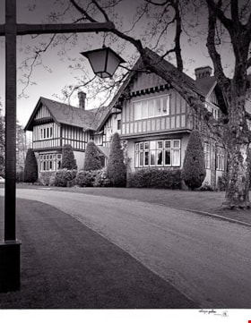
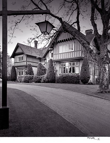
C. B. Riley Home - Western Homes & Living photographs
https://search.heritageburnaby.ca/link/archivedescription95583
- Repository
- City of Burnaby Archives
- Date
- March 1959
- Collection/Fonds
- City of Burnaby Archives photograph collection
- Description Level
- File
- Physical Description
- 2 photographs (tiff) and 3 p. of textual records (tiff, psd)
- Scope and Content
- File consists of a digitized copy of the article "Where Space is No Problem," from the March 1959 issue of Western Homes & Living Magazine, and related photographs. The article reports on the C. B. Riley home (formerly the F.J. Hart Estate "Avalon"; now Hart House) and includes floor plans and phot…
- Repository
- City of Burnaby Archives
- Date
- March 1959
- Collection/Fonds
- City of Burnaby Archives photograph collection
- Physical Description
- 2 photographs (tiff) and 3 p. of textual records (tiff, psd)
- Description Level
- File
- Record No.
- 625-001
- Access Restriction
- No restrictions
- Reproduction Restriction
- Reproduce for fair dealing purposes only
- Accession Number
- 2021-10
- Scope and Content
- File consists of a digitized copy of the article "Where Space is No Problem," from the March 1959 issue of Western Homes & Living Magazine, and related photographs. The article reports on the C. B. Riley home (formerly the F.J. Hart Estate "Avalon"; now Hart House) and includes floor plans and photographs of the house taken by Selwyn Pullan. Photographs in this file, which are also printed in the article, depict the kitchen and the exterior of the home.
- Subjects
- Buildings - Heritage
- Media Type
- Photograph
- Textual Record
- Photographer
- Pullan, Selwyn
- Notes
- Title based on content of file
- Street Address
- 6664 Deer Lake Avenue
- Historic Neighbourhood
- Burnaby Lake (Historic Neighbourhood)
- Planning Study Area
- Morley-Buckingham Area
Images
Copies of photographs from Esther (Love) Stanley albums
https://search.heritageburnaby.ca/link/museumdescription10003
- Repository
- Burnaby Village Museum
- Date
- [1915-1950] (date of originals), copied 1989
- Collection/Fonds
- Burnaby Village Museum fonds
- Description Level
- File
- Physical Description
- 36 photographs : b&w negatives ; 35 mm
- Scope and Content
- Photographs copied from various photograph albums including; Albert Paker, George Love, Gordon Love and Esther (Love) Stanley. Content includes: Love family in front of the piano inside parlour; Love family members with musical instruments inside parlour; Ben Brandrith and Robert Love in uniforms; …
- Repository
- Burnaby Village Museum
- Collection/Fonds
- Burnaby Village Museum fonds
- Series
- Jesse Love farmhouse series
- Subseries
- Love family photographs subseries
- Description Level
- File
- Physical Description
- 36 photographs : b&w negatives ; 35 mm
- Scope and Content
- Photographs copied from various photograph albums including; Albert Paker, George Love, Gordon Love and Esther (Love) Stanley. Content includes: Love family in front of the piano inside parlour; Love family members with musical instruments inside parlour; Ben Brandrith and Robert Love in uniforms; unidentified Asian man in field with hoe and young trees behind him; wedding cake from Frank Charles Stanley and Esther Love's wedding; land clearing for Love farmhouse; Jesse Love feeding chickens; Jesse and Hannah (Girlie) Love in hats outside on Love farm; large picnic on grass; four generations of Love family members; gatherings of Love family members outside; Love family posed in a car inside a studio (Will, Sarah, George, Phoebe and Martha); Leonard Love dressed as a boy scout; Martha (Dot) with children; Love family members celebrate centennial; Jesse Love and Martha (Dot) Love outside Love farmhouse; Love farmhouse with porch and garden; swing at Love farmhouse; Parker family in living room and view of the Love farmhouse from the front.
- Geographic Access
- Cumberland Street
- Street Address
- 7651 Cumberland Street
- Accession Code
- BV018.41.184
- Access Restriction
- No restrictions
- Reproduction Restriction
- May be restricted by third party rights
- Date
- [1915-1950] (date of originals), copied 1989
- Media Type
- Photograph
- Historic Neighbourhood
- East Burnaby (Historic Neighbourhood)
- Planning Study Area
- Cariboo-Armstrong Area
- Scan Date
- 4-Mar-2019
- Notes
- Title based on contents of photograph
- 36 b&w copy prints accompanying
![Mathers House, [1950] thumbnail](/media/hpo/_Data/_Archives_Images/_Unrestricted/371/405-005.jpg?width=280)
Mathers House
https://search.heritageburnaby.ca/link/archivedescription39808
- Repository
- City of Burnaby Archives
- Date
- [1950]
- Collection/Fonds
- Burnaby Historical Society fonds
- Description Level
- Item
- Physical Description
- 1 photograph : b&w ; 6.5 x 8.2 cm
- Scope and Content
- Photograph of the Mathers house at Deer Lake, which also served as the Seminary of Christ the King.
- Repository
- City of Burnaby Archives
- Date
- [1950]
- Collection/Fonds
- Burnaby Historical Society fonds
- Subseries
- Photographs subseries
- Physical Description
- 1 photograph : b&w ; 6.5 x 8.2 cm
- Description Level
- Item
- Record No.
- 405-005
- Access Restriction
- No restrictions
- Reproduction Restriction
- Reproduce for fair dealing purposes only
- Accession Number
- BHS2000-5
- Scope and Content
- Photograph of the Mathers house at Deer Lake, which also served as the Seminary of Christ the King.
- Subjects
- Buildings - Heritage
- Media Type
- Photograph
- Notes
- Title based on contents of photograph
- Geographic Access
- Deer Lake Avenue
- Street Address
- 6490 Deer Lake Avenue
- Historic Neighbourhood
- Burnaby Lake (Historic Neighbourhood)
- Planning Study Area
- Douglas-Gilpin Area
Images
![Mathers House, [1950] thumbnail](/media/hpo/_Data/_Archives_Images/_Unrestricted/371/405-005.jpg)
![Parkers at Christmas dinner, [ca. 1950] (date of original), copied 1998 thumbnail](/media/hpo/_Data/_BVM_Images/2018/2018_0041_0176_001.jpg?width=280)
Parkers at Christmas dinner
https://search.heritageburnaby.ca/link/museumdescription9991
- Repository
- Burnaby Village Museum
- Date
- [ca. 1950] (date of original), copied 1998
- Collection/Fonds
- Burnaby Village Museum fonds
- Description Level
- Item
- Physical Description
- 1 photograph : b&w negative ; 35 mm
- Scope and Content
- Photograph of six members of the Parker family celebrating Christmas dinner. They are seated around a table in the dining room of the Love farmhouse, everyone is wearing a party hat and there is a decorated Christmas tree in the background. People are identified from L to R as; Sarah (Love) Parker,…
- Repository
- Burnaby Village Museum
- Collection/Fonds
- Burnaby Village Museum fonds
- Series
- Jesse Love farmhouse series
- Subseries
- Love family photographs subseries
- Description Level
- Item
- Physical Description
- 1 photograph : b&w negative ; 35 mm
- Scope and Content
- Photograph of six members of the Parker family celebrating Christmas dinner. They are seated around a table in the dining room of the Love farmhouse, everyone is wearing a party hat and there is a decorated Christmas tree in the background. People are identified from L to R as; Sarah (Love) Parker, May Parker, William Michael Parker, Bill (William Charles) Parker and May and Bill's two daughters. William and Sarah (nee Love) Parker purchased the Love farmhouse at 1390 Cumberland Road in 1928 after Sarah's father, Jesse Love died. William and Sarah lived there with their three children Albert, Bill and Elsie until 1961.
- Subjects
- Buildings - Heritage
- Geographic Access
- Cumberland Street
- Street Address
- 7651 Cumberland Street
- Accession Code
- BV018.41.176
- Access Restriction
- No restrictions
- Reproduction Restriction
- May be restricted by third party rights
- Date
- [ca. 1950] (date of original), copied 1998
- Media Type
- Photograph
- Historic Neighbourhood
- East Burnaby (Historic Neighbourhood)
- Planning Study Area
- Cariboo-Armstrong Area
- Scan Resolution
- 2400
- Scan Date
- 4-Mar-2019
- Scale
- 100
- Notes
- Title based on contents of photograph
- 1 b&w copy print accompanying
Images
![Parkers at Christmas dinner, [ca. 1950] (date of original), copied 1998 thumbnail](/media/hpo/_Data/_BVM_Images/2018/2018_0041_0176_001.jpg)
![Barns at Oakalla, [195-] (date of original), copied 1991 thumbnail](/media/hpo/_Data/_Archives_Images/_Unrestricted/370/370-706.jpg?width=280)
Barns at Oakalla
https://search.heritageburnaby.ca/link/archivedescription38119
- Repository
- City of Burnaby Archives
- Date
- [195-] (date of original), copied 1991
- Collection/Fonds
- Burnaby Historical Society fonds
- Description Level
- Item
- Physical Description
- 1 photograph : b&w ; 2.8 x 4.1 cm print on contact sheet 20.1 x 26.5 cm
- Scope and Content
- Photograph of the exterior of horse and cattle barns at Oakalla Prison Farm.
- Repository
- City of Burnaby Archives
- Date
- [195-] (date of original), copied 1991
- Collection/Fonds
- Burnaby Historical Society fonds
- Subseries
- Burnaby Image Bank subseries
- Physical Description
- 1 photograph : b&w ; 2.8 x 4.1 cm print on contact sheet 20.1 x 26.5 cm
- Description Level
- Item
- Record No.
- 370-706
- Access Restriction
- No restrictions
- Reproduction Restriction
- Reproduce for fair dealing purposes only
- Accession Number
- BHS1999-03
- Scope and Content
- Photograph of the exterior of horse and cattle barns at Oakalla Prison Farm.
- Subjects
- Buildings - Agricultural - Barns
- Agriculture - Farms
- Buildings - Public - Detention Facilities
- Names
- Oakalla Prison Farm
- Media Type
- Photograph
- Notes
- Title based on contents of photograph
- 1 b&w copy negative accompanying
- Negative has a pink cast
- Geographic Access
- Oakmount Crescent
- Street Address
- 5220 Oakmount Crescent
- Historic Neighbourhood
- Burnaby Lake (Historic Neighbourhood)
- Planning Study Area
- Oakalla Area
Images
![Barns at Oakalla, [195-] (date of original), copied 1991 thumbnail](/media/hpo/_Data/_Archives_Images/_Unrestricted/370/370-706.jpg)
![Bonsor Hall, [1958] thumbnail](/media/Hpo/_Data/_Archives_Images/_Unrestricted/316/345-003.jpg?width=280)
Bonsor Hall
https://search.heritageburnaby.ca/link/archivedescription37282
- Repository
- City of Burnaby Archives
- Date
- [1958]
- Collection/Fonds
- Burnaby Historical Society fonds
- Description Level
- Item
- Physical Description
- 1 photograph : b&w ; 9 x 9 cm
- Scope and Content
- Photograph of the Bonsor Hall (formerly the Kingsway West School). A note on the back of the photograph reads: "The Old Bonsor Hall - Formerly Kingsway W. School as in Burnaby Courier." The photograph was taken by the Burnaby Courier newspaper ca. 1958.
- Repository
- City of Burnaby Archives
- Date
- [1958]
- Collection/Fonds
- Burnaby Historical Society fonds
- Subseries
- Norah Code subseries
- Physical Description
- 1 photograph : b&w ; 9 x 9 cm
- Description Level
- Item
- Record No.
- 345-003
- Access Restriction
- No restrictions
- Reproduction Restriction
- Reproduce for fair dealing purposes only
- Accession Number
- BHS1997-05
- Scope and Content
- Photograph of the Bonsor Hall (formerly the Kingsway West School). A note on the back of the photograph reads: "The Old Bonsor Hall - Formerly Kingsway W. School as in Burnaby Courier." The photograph was taken by the Burnaby Courier newspaper ca. 1958.
- Names
- Bonsor Hall
- Media Type
- Photograph
- Photographer
- Code, Norah
- Notes
- Title based on caption.
- Photographs in this collection were taken and compiled by Norah Code, former editor of the "Burnaby Courier" newspaper during the course of her work for the newspaper.
- Geographic Access
- Kingsway
- Street Address
- 4800 Kingsway
- Historic Neighbourhood
- Central Park (Historic Neighbourhood)
- Planning Study Area
- Maywood Area
Images
![Bonsor Hall, [1958] thumbnail](/media/Hpo/_Data/_Archives_Images/_Unrestricted/316/345-003.jpg)
![Calf Barn at Oakalla, [195-] (date of original), copied 1991 thumbnail](/media/hpo/_Data/_Archives_Images/_Unrestricted/370/370-718.jpg?width=280)
Calf Barn at Oakalla
https://search.heritageburnaby.ca/link/archivedescription38131
- Repository
- City of Burnaby Archives
- Date
- [195-] (date of original), copied 1991
- Collection/Fonds
- Burnaby Historical Society fonds
- Description Level
- Item
- Physical Description
- 1 photograph : b&w ; 3.0 x 4.3 cm print on contact sheet 19.8 x 26.2 cm
- Scope and Content
- Photograph of the exterior of the calf barn at Oakalla Prison Farm.
- Repository
- City of Burnaby Archives
- Date
- [195-] (date of original), copied 1991
- Collection/Fonds
- Burnaby Historical Society fonds
- Subseries
- Burnaby Image Bank subseries
- Physical Description
- 1 photograph : b&w ; 3.0 x 4.3 cm print on contact sheet 19.8 x 26.2 cm
- Description Level
- Item
- Record No.
- 370-718
- Access Restriction
- No restrictions
- Reproduction Restriction
- Reproduce for fair dealing purposes only
- Accession Number
- BHS1999-03
- Scope and Content
- Photograph of the exterior of the calf barn at Oakalla Prison Farm.
- Subjects
- Buildings - Agricultural - Barns
- Agriculture - Farms
- Buildings - Public - Detention Facilities
- Names
- Oakalla Prison Farm
- Media Type
- Photograph
- Notes
- Title based on contents of photograph
- 1 b&w copy negative accompanying
- Negative has a pink cast
- Geographic Access
- Oakmount Crescent
- Street Address
- 5220 Oakmount Crescent
- Historic Neighbourhood
- Burnaby Lake (Historic Neighbourhood)
- Planning Study Area
- Oakalla Area
Images
![Calf Barn at Oakalla, [195-] (date of original), copied 1991 thumbnail](/media/hpo/_Data/_Archives_Images/_Unrestricted/370/370-718.jpg)

Esso Filling Station
https://search.heritageburnaby.ca/link/archivedescription34591
- Repository
- City of Burnaby Archives
- Date
- 1958
- Collection/Fonds
- Burnaby Historical Society fonds
- Description Level
- Item
- Physical Description
- 1 photograph : b&w ; 20.2 x 25.4 cm
- Scope and Content
- Photograph of the Esso filling station at Lake City with trucks parked in an industrial area.
- Repository
- City of Burnaby Archives
- Date
- 1958
- Collection/Fonds
- Burnaby Historical Society fonds
- Subseries
- Photographs subseries
- Physical Description
- 1 photograph : b&w ; 20.2 x 25.4 cm
- Description Level
- Item
- Record No.
- 064-001
- Access Restriction
- No restrictions
- Reproduction Restriction
- Reproduce for fair dealing purposes only
- Accession Number
- BHS2007-04
- Scope and Content
- Photograph of the Esso filling station at Lake City with trucks parked in an industrial area.
- Names
- Esso
- Media Type
- Photograph
- Notes
- Title based on contents of photograph
- Planning Study Area
- Lake City Area
Images


Extension of McPherson Park School
https://search.heritageburnaby.ca/link/archivedescription36489
- Repository
- City of Burnaby Archives
- Date
- September 1959
- Collection/Fonds
- Burnaby Historical Society fonds
- Description Level
- Item
- Physical Description
- 1 photograph : b&w ; 8.5 x 12.5 cm print
- Scope and Content
- Photograph of the A.J. Keel house with excavation for the extension of the McPherson Park School.
- Repository
- City of Burnaby Archives
- Date
- September 1959
- Collection/Fonds
- Burnaby Historical Society fonds
- Subseries
- Keel family subseries
- Physical Description
- 1 photograph : b&w ; 8.5 x 12.5 cm print
- Description Level
- Item
- Record No.
- 279-002
- Access Restriction
- No restrictions
- Reproduction Restriction
- Reproduce for fair dealing purposes only
- Accession Number
- BHS1992-09
- Scope and Content
- Photograph of the A.J. Keel house with excavation for the extension of the McPherson Park School.
- Names
- McPherson Park School
- Media Type
- Photograph
- Notes
- Title based on contents of photograph
- Geographic Access
- Rumble Street
- Historic Neighbourhood
- Alta-Vista (Historic Neighbourhood)
- Planning Study Area
- Clinton-Glenwood Area
Images


Extension of McPherson Park School
https://search.heritageburnaby.ca/link/archivedescription36490
- Repository
- City of Burnaby Archives
- Date
- September 1959
- Collection/Fonds
- Burnaby Historical Society fonds
- Description Level
- Item
- Physical Description
- 1 photograph : b&w ; 8.5 x 12.5 cm print
- Scope and Content
- Photograph of the A.J. Keel house with a close-up of the excavation for the extension of McPherson Park School.
- Repository
- City of Burnaby Archives
- Date
- September 1959
- Collection/Fonds
- Burnaby Historical Society fonds
- Subseries
- Keel family subseries
- Physical Description
- 1 photograph : b&w ; 8.5 x 12.5 cm print
- Description Level
- Item
- Record No.
- 279-003
- Access Restriction
- No restrictions
- Reproduction Restriction
- Reproduce for fair dealing purposes only
- Accession Number
- BHS1992-09
- Scope and Content
- Photograph of the A.J. Keel house with a close-up of the excavation for the extension of McPherson Park School.
- Names
- McPherson Park School
- Media Type
- Photograph
- Notes
- Title based on contents of photograph
- Geographic Access
- Rumble Street
- Historic Neighbourhood
- Alta-Vista (Historic Neighbourhood)
- Planning Study Area
- Clinton-Glenwood Area
Images

![Fire Hall at Oakalla, [195-] (date of original), copied 1991 thumbnail](/media/hpo/_Data/_Archives_Images/_Unrestricted/370/370-698.jpg?width=280)
Fire Hall at Oakalla
https://search.heritageburnaby.ca/link/archivedescription38111
- Repository
- City of Burnaby Archives
- Date
- [195-] (date of original), copied 1991
- Collection/Fonds
- Burnaby Historical Society fonds
- Description Level
- Item
- Physical Description
- 1 photograph : b&w ; 2.9 x 4.2 cm print on contact sheet 20.7 x 26.7 cm
- Scope and Content
- Photograph of the exterior of the fire hall at Oakalla Prison Farm.
- Repository
- City of Burnaby Archives
- Date
- [195-] (date of original), copied 1991
- Collection/Fonds
- Burnaby Historical Society fonds
- Subseries
- Burnaby Image Bank subseries
- Physical Description
- 1 photograph : b&w ; 2.9 x 4.2 cm print on contact sheet 20.7 x 26.7 cm
- Description Level
- Item
- Record No.
- 370-698
- Access Restriction
- No restrictions
- Reproduction Restriction
- Reproduce for fair dealing purposes only
- Accession Number
- BHS1999-03
- Scope and Content
- Photograph of the exterior of the fire hall at Oakalla Prison Farm.
- Names
- Oakalla Prison Farm
- Media Type
- Photograph
- Notes
- Title based on contents of photograph
- 1 b&w copy negative accompanying
- Negative has a pink cast
- Geographic Access
- Oakmount Crescent
- Street Address
- 5220 Oakmount Crescent
- Historic Neighbourhood
- Burnaby Lake (Historic Neighbourhood)
- Planning Study Area
- Oakalla Area
Images
![Fire Hall at Oakalla, [195-] (date of original), copied 1991 thumbnail](/media/hpo/_Data/_Archives_Images/_Unrestricted/370/370-698.jpg)