More like 'Simon Fraser University graduation'
Narrow Results By
Decade
- 2020s 143
- 2010s 86
- 2000s 1028
- 1990s 620
- 1980s 553
- 1970s 1306
- 1960s 395
- 1950s 610
- 1940s 631
- 1930s 516
- 1920s 565
- 1910s
- 1900s 216
- 1890s 37
- 1880s 53
- 1870s 7
- 1860s 3
- 1850s 1
- 1840s 1
- 1830s 2
- 1820s 1
- 1810s 1
- 1800s 1
- 1790s 1
- 1780s 1
- 1770s 1
- 1760s 1
- 1750s 1
- 1740s 1
- 1730s 1
- 1720s 1
- 1710s 1
- 1700s 1
- 1690s 1
- 1680s 1
- 1670s 1
- 1660s 1
- 1650s 1
- 1640s 1
- 1630s 1
- 1620s 1
- 1610s 1
- 1600s 1
Creator
- Barrowclough, G.A. 1
- Barrowclough, George Alfred 1
- BC Photo Card Company 1
- Brown, W. 1
- Burnaby Village Museum 5
- Burnett and McGugan B.C. Land Surveyors, New Westminster 5
- Burnett, Geoffrey K. 3
- Burnett & McGugan, Engineers and Surveyors 22
- Canadian Photo Company 12
- Challoner-Courtenay, E.J. 2
- Damer, Eric 1
- Dean, H.M. 13

Armstrong Street School site
https://search.heritageburnaby.ca/link/museumdescription11133
- Repository
- Burnaby Village Museum
- Date
- 1915
- Collection/Fonds
- Ronald G. Scobbie collection
- Description Level
- Item
- Physical Description
- 1 survey plan : blueprint on paper ; 56 x 54 cm
- Scope and Content
- Survey plan of "Armstrong Street School Site / Burnaby Municipality" "Being a 2 acre portion of Lot 13 Group 1, & according to map 1722 which shows this as Lot E. Block 2 of subdivision of a portion, of Lot 13, Group 1, New Westminster District".
- Repository
- Burnaby Village Museum
- Collection/Fonds
- Ronald G. Scobbie collection
- Description Level
- Item
- Physical Description
- 1 survey plan : blueprint on paper ; 56 x 54 cm
- Material Details
- Scale 40 feet = 1 inch
- Scope and Content
- Survey plan of "Armstrong Street School Site / Burnaby Municipality" "Being a 2 acre portion of Lot 13 Group 1, & according to map 1722 which shows this as Lot E. Block 2 of subdivision of a portion, of Lot 13, Group 1, New Westminster District".
- Creator
- Burnett, Geoffrey K.
- Subjects
- Buildings - Schools
- Names
- Armstrong Avenue School
- Responsibility
- Burnett & McGugan, Engineers and Surveyors
- Geographic Access
- Armstrong Avenue
- Street Address
- 8757 Armstrong Avenue
- Accession Code
- BV003.83.12
- Access Restriction
- No restrictions
- Reproduction Restriction
- No known restrictions
- Date
- 1915
- Media Type
- Cartographic Material
- Historic Neighbourhood
- East Burnaby (Historic Neighbourhood)
- Planning Study Area
- Cariboo-Armstrong Area
- Scan Resolution
- 440
- Scan Date
- 22-Dec-2020
- Scale
- 100
- Notes
- Title based on contents of plan
- Note in black ink on verso of plan reads: "1746"
- Oath on plan reads: "I, Geoffrey K. Burnett...and did personally superintend the survey represented..." "Completed on the 18th day of March 1915"; signed by Geoffrey K. Burnett and notarized by "K.A. Eastman", sworn "...19th day of April 1915"; "Burnett and McGugan., B.C. Land Surveyors. Etc.. New Westminster, B.C.."
Zoomable Images

![Back of Kingsway East School, [between 1914 and 1919] thumbnail](/media/hpo/_Data/_Archives_Images/_Unrestricted/316/325-029.jpg?width=280)
Back of Kingsway East School
https://search.heritageburnaby.ca/link/archivedescription37157
- Repository
- City of Burnaby Archives
- Date
- [between 1914 and 1919]
- Collection/Fonds
- Burnaby Historical Society fonds
- Description Level
- Item
- Physical Description
- 1 photograph : b&w ; 8 x 12.5 cm print
- Scope and Content
- Photograph of the back of Kingsway East School and surrounding fields.
- Repository
- City of Burnaby Archives
- Date
- [between 1914 and 1919]
- Collection/Fonds
- Burnaby Historical Society fonds
- Subseries
- Disney family subseries
- Physical Description
- 1 photograph : b&w ; 8 x 12.5 cm print
- Description Level
- Item
- Record No.
- 325-029
- Access Restriction
- No restrictions
- Reproduction Restriction
- No known restrictions
- Accession Number
- BHS1996-04
- Scope and Content
- Photograph of the back of Kingsway East School and surrounding fields.
- Subjects
- Buildings - Schools
- Names
- Kingsway East School
- Media Type
- Photograph
- Photographer
- Disney, John Harold "Jack"
- Notes
- Title based on contents of photograph
- Geographic Access
- Kingsway
- Mission Avenue
- Street Address
- 6650 Southoaks Crescent
- Historic Neighbourhood
- Edmonds (Historic Neighbourhood)
- Planning Study Area
- Kingsway-Beresford Area
Images
![Back of Kingsway East School, [between 1914 and 1919] thumbnail](/media/hpo/_Data/_Archives_Images/_Unrestricted/316/325-029.jpg)
![Back of the Barnet School, [between 1911 and 1919] thumbnail](/media/hpo/_Data/_Archives_Images/_Unrestricted/316/325-019.jpg?width=280)
Back of the Barnet School
https://search.heritageburnaby.ca/link/archivedescription37147
- Repository
- City of Burnaby Archives
- Date
- [between 1911 and 1919]
- Collection/Fonds
- Burnaby Historical Society fonds
- Description Level
- Item
- Physical Description
- 1 photograph : b&w ; 8.5 x 12.5 cm print
- Scope and Content
- Photograph of the back of the Barnet School and its adjoining teacher's residence.
- Repository
- City of Burnaby Archives
- Date
- [between 1911 and 1919]
- Collection/Fonds
- Burnaby Historical Society fonds
- Subseries
- Disney family subseries
- Physical Description
- 1 photograph : b&w ; 8.5 x 12.5 cm print
- Description Level
- Item
- Record No.
- 325-019
- Access Restriction
- No restrictions
- Reproduction Restriction
- No known restrictions
- Accession Number
- BHS1996-04
- Scope and Content
- Photograph of the back of the Barnet School and its adjoining teacher's residence.
- Subjects
- Buildings - Schools
- Names
- Barnet School
- Media Type
- Photograph
- Photographer
- Disney, John Harold "Jack"
- Notes
- Title based on contents of photograph
- Geographic Access
- Barnet Road
- Street Address
- 7820 Barnet Road
- Historic Neighbourhood
- Barnet (Historic Neighbourhood)
- Planning Study Area
- Burnaby Mountain Area
Images
![Back of the Barnet School, [between 1911 and 1919] thumbnail](/media/hpo/_Data/_Archives_Images/_Unrestricted/316/325-019.jpg)
![Barnet School, [between 1911 and 1919] thumbnail](/media/hpo/_Data/_Archives_Images/_Unrestricted/316/325-018.jpg?width=280)
Barnet School
https://search.heritageburnaby.ca/link/archivedescription37146
- Repository
- City of Burnaby Archives
- Date
- [between 1911 and 1919]
- Collection/Fonds
- Burnaby Historical Society fonds
- Description Level
- Item
- Physical Description
- 1 photograph : b&w ; 8.5 x 12.5 cm print
- Scope and Content
- Photograph of Barnet School and the adjoining teacher's residence.
- Repository
- City of Burnaby Archives
- Date
- [between 1911 and 1919]
- Collection/Fonds
- Burnaby Historical Society fonds
- Subseries
- Disney family subseries
- Physical Description
- 1 photograph : b&w ; 8.5 x 12.5 cm print
- Description Level
- Item
- Record No.
- 325-018
- Access Restriction
- No restrictions
- Reproduction Restriction
- No known restrictions
- Accession Number
- BHS1996-04
- Scope and Content
- Photograph of Barnet School and the adjoining teacher's residence.
- Subjects
- Buildings - Schools
- Names
- Barnet School
- Media Type
- Photograph
- Photographer
- Disney, John Harold "Jack"
- Notes
- Title based on contents of photograph
- Geographic Access
- Barnet Road
- Street Address
- 7820 Barnet Road
- Historic Neighbourhood
- Barnet (Historic Neighbourhood)
- Planning Study Area
- Burnaby Mountain Area
Images
![Barnet School, [between 1911 and 1919] thumbnail](/media/hpo/_Data/_Archives_Images/_Unrestricted/316/325-018.jpg)

Barnet School site
https://search.heritageburnaby.ca/link/museumdescription11140
- Repository
- Burnaby Village Museum
- Date
- May 27, 1915
- Collection/Fonds
- Ronald G. Scobbie collection
- Description Level
- Item
- Physical Description
- 1 survey plan : blueprint on paper ; 56 x 54 cm
- Scope and Content
- Survey plan of "Barnet School Site / Burnaby Municipality" "Being a portion of the west half of lot / 214, Group 1 / New Westminster District”.
- Repository
- Burnaby Village Museum
- Collection/Fonds
- Ronald G. Scobbie collection
- Description Level
- Item
- Physical Description
- 1 survey plan : blueprint on paper ; 56 x 54 cm
- Material Details
- Scale 40 feet = 1 inch
- Scope and Content
- Survey plan of "Barnet School Site / Burnaby Municipality" "Being a portion of the west half of lot / 214, Group 1 / New Westminster District”.
- Creator
- McGugan, Donald Johnston
- Subjects
- Buildings - Schools
- Names
- Barnet School
- Responsibility
- Burnett & McGugan, Engineers and Surveyors
- Geographic Access
- Barnet Road
- Street Address
- 7820 Barnet Road
- Accession Code
- BV003.83.19
- Access Restriction
- No restrictions
- Reproduction Restriction
- No known restrictions
- Date
- May 27, 1915
- Media Type
- Cartographic Material
- Historic Neighbourhood
- Barnet (Historic Neighbourhood)
- Planning Study Area
- Burnaby Mountain Area
- Scan Resolution
- 440
- Scan Date
- 22-Dec-2020
- Scale
- 100
- Notes
- Title based on contents of plan
- handwritten on back "Burnaby Schools" "23R" twice, "1783"
- Oath on plan reads: "I, D.J. McGugan...and did personally superintend the survey..." "completed on the 27th day of May 1915"; signed by D.J. McGugan, notarized by "Walter Edmonds" "sworn "...29th day of May 1915" "Burnett and McGugan" "B.C. Land Surveyors Etc. New Westminster, B.C.";
Zoomable Images


Broadview School
https://search.heritageburnaby.ca/link/archivedescription38237
- Repository
- City of Burnaby Archives
- Date
- 1912
- Collection/Fonds
- Burnaby Historical Society fonds
- Description Level
- Item
- Physical Description
- 1 photograph : sepia ; 16.5 x 21.2 cm on 24.5 x 29.5 cm backing
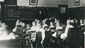
- Scope and Content
- Photograph of a class of approximately fifty-three children and two teachers outside the newly built Broadview area school. This was the first class photograph at the Broadview School. This shool was later replaced by the Schou Street School and the building was used as a community centre.
- Repository
- City of Burnaby Archives
- Date
- 1912
- Collection/Fonds
- Burnaby Historical Society fonds
- Subseries
- Margaret McCallum subseries
- Physical Description
- 1 photograph : sepia ; 16.5 x 21.2 cm on 24.5 x 29.5 cm backing
- Description Level
- Item
- Record No.
- 375-012
- Access Restriction
- No restrictions
- Reproduction Restriction
- No known restrictions
- Accession Number
- BHS1986-42
- Scope and Content
- Photograph of a class of approximately fifty-three children and two teachers outside the newly built Broadview area school. This was the first class photograph at the Broadview School. This shool was later replaced by the Schou Street School and the building was used as a community centre.
- Names
- Schou Street School
- Media Type
- Photograph
- Notes
- Title based on contents of photograph
- Geographic Access
- Gilmore Avenue
- Grandview Highway
- Canada Way
- Street Address
- 4054 Norfolk Street
- Historic Neighbourhood
- Broadview (Historic Neighbourhood)
- Planning Study Area
- Cascade-Schou Area
Images

Clarice Wilks' Fraser Mills Class
https://search.heritageburnaby.ca/link/archivedescription35445
- Repository
- City of Burnaby Archives
- Date
- 1912 (date of original), copied 1986
- Collection/Fonds
- Burnaby Historical Society fonds
- Description Level
- Item
- Physical Description
- 1 photograph : b&w ; 12.7 x 17.8 cm print
- Scope and Content
- Photograph of Clarice Wilks in her class at Fraser Mills (now Coquitlam). Students are seated at desks in a classroom and Clarice Wilks is standing by the blackboard at the front of the class. Clarice Wilks (later Clarice Eaton) was the wife of early Vancouver Heights resident, Dr. Carl Eaton. She …
- Repository
- City of Burnaby Archives
- Date
- 1912 (date of original), copied 1986
- Collection/Fonds
- Burnaby Historical Society fonds
- Subseries
- Pioneer Tales subseries
- Physical Description
- 1 photograph : b&w ; 12.7 x 17.8 cm print
- Description Level
- Item
- Record No.
- 204-303
- Access Restriction
- No restrictions
- Reproduction Restriction
- No restrictions
- Accession Number
- BHS1988-03
- Scope and Content
- Photograph of Clarice Wilks in her class at Fraser Mills (now Coquitlam). Students are seated at desks in a classroom and Clarice Wilks is standing by the blackboard at the front of the class. Clarice Wilks (later Clarice Eaton) was the wife of early Vancouver Heights resident, Dr. Carl Eaton. She taught school in Fraser Mills and travelled there daily on the Burnaby Lake Interurban.
- Names
- Eaton, Clarice Wilks
- Media Type
- Photograph
- Photographer
- Eaton, Dr. Carl
- Notes
- Title based on contents of photograph
Images


Detail of brass plates for monuments in connection with school sites in Burnaby
https://search.heritageburnaby.ca/link/museumdescription11919
- Repository
- Burnaby Village Museum
- Date
- March 6, 1915
- Collection/Fonds
- Ronald G. Scobbie collection
- Description Level
- Item
- Physical Description
- 1 architectural drawing : pencil and watercolour on blueprint paper ; 43.5 x 30 cm
- Scope and Content
- Item consists of a detail drawing titled "Detail of Brass Plates / for monuments in connection / with School sites, Burnaby - / Full Size”.
- Repository
- Burnaby Village Museum
- Collection/Fonds
- Ronald G. Scobbie collection
- Description Level
- Item
- Physical Description
- 1 architectural drawing : pencil and watercolour on blueprint paper ; 43.5 x 30 cm
- Scope and Content
- Item consists of a detail drawing titled "Detail of Brass Plates / for monuments in connection / with School sites, Burnaby - / Full Size”.
- Creator
- McGugan, Donald Johnston
- Subjects
- Buildings - Schools
- Responsibility
- Burnett & McGugan, Engineers and Surveyors
- Accession Code
- BV003.83.11
- Access Restriction
- No restrictions
- Reproduction Restriction
- No known restrictions
- Date
- March 6, 1915
- Media Type
- Architectural Drawing
- Scan Resolution
- 600
- Scan Date
- 15-Jan-2021
- Scale
- 100
- Notes
- Title based on contents of drawing
- Text on bottom right corner of drawing reads: "Burnett & McGugan / C.E. & B.C. Land Surveyors / New Westminster, BC / 6th March 1915"
- Red crayon marking on plan reads: "001819"
- verso of page is blue
Images

![Douglas Road School, [between 1911 and 1919] thumbnail](/media/hpo/_Data/_Archives_Images/_Unrestricted/316/325-037.jpg?width=280)
Douglas Road School
https://search.heritageburnaby.ca/link/archivedescription37165
- Repository
- City of Burnaby Archives
- Date
- [between 1911 and 1919]
- Collection/Fonds
- Burnaby Historical Society fonds
- Description Level
- Item
- Physical Description
- 1 photograph : b&w ; 12.5 x 8 cm print
- Scope and Content
- Photograph of Douglas Road School, taken from a distance, and including the two large trees in the front playing field.
- Repository
- City of Burnaby Archives
- Date
- [between 1911 and 1919]
- Collection/Fonds
- Burnaby Historical Society fonds
- Subseries
- Disney family subseries
- Physical Description
- 1 photograph : b&w ; 12.5 x 8 cm print
- Description Level
- Item
- Record No.
- 325-037
- Access Restriction
- No restrictions
- Reproduction Restriction
- No known restrictions
- Accession Number
- BHS1996-04
- Scope and Content
- Photograph of Douglas Road School, taken from a distance, and including the two large trees in the front playing field.
- Subjects
- Buildings - Schools
- Names
- Douglas Road School
- Media Type
- Photograph
- Photographer
- Disney, John Harold "Jack"
- Notes
- Title based on contents of photograph
- Geographic Access
- Canada Way
- Street Address
- 4861 Canada Way
- Historic Neighbourhood
- Burnaby Lake (Historic Neighbourhood)
- Planning Study Area
- Douglas-Gilpin Area
Images
![Douglas Road School, [between 1911 and 1919] thumbnail](/media/hpo/_Data/_Archives_Images/_Unrestricted/316/325-037.jpg)
![Douglas Road School, [between 1911 and 1919] thumbnail](/media/hpo/_Data/_Archives_Images/_Unrestricted/316/325-038.jpg?width=280)
Douglas Road School
https://search.heritageburnaby.ca/link/archivedescription37166
- Repository
- City of Burnaby Archives
- Date
- [between 1911 and 1919]
- Collection/Fonds
- Burnaby Historical Society fonds
- Description Level
- Item
- Physical Description
- 1 photograph : b&w ; 7.5 x 12.5 cm print
- Scope and Content
- Photograph of the back of Douglas Road School, and the back field.
- Repository
- City of Burnaby Archives
- Date
- [between 1911 and 1919]
- Collection/Fonds
- Burnaby Historical Society fonds
- Subseries
- Disney family subseries
- Physical Description
- 1 photograph : b&w ; 7.5 x 12.5 cm print
- Description Level
- Item
- Record No.
- 325-038
- Access Restriction
- No restrictions
- Reproduction Restriction
- No known restrictions
- Accession Number
- BHS1996-04
- Scope and Content
- Photograph of the back of Douglas Road School, and the back field.
- Subjects
- Buildings - Schools
- Names
- Douglas Road School
- Media Type
- Photograph
- Photographer
- Disney, John Harold "Jack"
- Notes
- Title based on contents of photograph
- Geographic Access
- Canada Way
- Street Address
- 4861 Canada Way
- Historic Neighbourhood
- Burnaby Lake (Historic Neighbourhood)
- Planning Study Area
- Douglas-Gilpin Area
Images
![Douglas Road School, [between 1911 and 1919] thumbnail](/media/hpo/_Data/_Archives_Images/_Unrestricted/316/325-038.jpg)

Douglas Road School site
https://search.heritageburnaby.ca/link/museumdescription11136
- Repository
- Burnaby Village Museum
- Date
- April 19, 1915
- Collection/Fonds
- Ronald G. Scobbie collection
- Description Level
- Item
- Physical Description
- 1 survey plan : blueprint on paper ; 56 x 54 cm
- Scope and Content
- Survey plan of "Douglas Road School Site / Burnaby Municipality" "Being Lot 21, of Blocks 1-5 inc. 11 & 12 of the subd. of north half of Lot 80, Group 1, New Westminster District".
- Repository
- Burnaby Village Museum
- Collection/Fonds
- Ronald G. Scobbie collection
- Description Level
- Item
- Physical Description
- 1 survey plan : blueprint on paper ; 56 x 54 cm
- Material Details
- Scale 40 feet = 1 inch
- Scope and Content
- Survey plan of "Douglas Road School Site / Burnaby Municipality" "Being Lot 21, of Blocks 1-5 inc. 11 & 12 of the subd. of north half of Lot 80, Group 1, New Westminster District".
- Creator
- McGugan, Donald Johnston
- Subjects
- Buildings - Schools
- Names
- Douglas Road School
- Responsibility
- Burnett & McGugan, Engineers and Surveyors
- Geographic Access
- Canada Way
- Street Address
- 4861 Canada Way
- Accession Code
- BV003.83.15
- Access Restriction
- No restrictions
- Reproduction Restriction
- No known restrictions
- Date
- April 19, 1915
- Media Type
- Cartographic Material
- Historic Neighbourhood
- Burnaby Lake (Historic Neighbourhood)
- Planning Study Area
- Douglas-Gilpin Area
- Scan Resolution
- 440
- Scan Date
- 22-Dec-2020
- Scale
- 100
- Notes
- Title based on contents of plan
- Note in black ink on verso of plan reads: "1747"
- Oath on plan reads: "I, D.G. McGugan..." "...and did person- ally superintend the survey..." "...completed on the 3rd day of April 1915"; signed by D.J. McGugan, notarized by "H.A. Eastman", sworn "...19th day of April 1915" "Burnett and McGugan" "B.C. Land Surveyors Etc. New Westminster, B.C.."
Images


Edmonds Street School
https://search.heritageburnaby.ca/link/archivedescription34553
- Repository
- City of Burnaby Archives
- Date
- 1914
- Collection/Fonds
- Burnaby Historical Society fonds
- Description Level
- Item
- Physical Description
- 1 photograph : sepia ; 16.0 x 21.2 cm mounted on 25.1 x 30.2 cm cardboard
- Scope and Content
- Photograph of the exterior of Edmonds Street School.
- Repository
- City of Burnaby Archives
- Date
- 1914
- Collection/Fonds
- Burnaby Historical Society fonds
- Subseries
- Photographs subseries
- Physical Description
- 1 photograph : sepia ; 16.0 x 21.2 cm mounted on 25.1 x 30.2 cm cardboard
- Description Level
- Item
- Record No.
- 044-013
- Access Restriction
- No restrictions
- Reproduction Restriction
- No known restrictions
- Accession Number
- BHS2007-04
- Scope and Content
- Photograph of the exterior of Edmonds Street School.
- Subjects
- Buildings - Schools
- Names
- Edmonds Community School
- Media Type
- Photograph
- Notes
- Title based on contents of photograph
- Geographic Access
- Edmonds Street
- Street Address
- 7641 Edmonds Street
- Historic Neighbourhood
- Edmonds (Historic Neighbourhood)
- Planning Study Area
- Edmonds Area
Images
Edmonds Street School
https://search.heritageburnaby.ca/link/archivedescription34825
- Repository
- City of Burnaby Archives
- Date
- June 11, 1911 (date of original), copied 1985
- Collection/Fonds
- Burnaby Historical Society fonds
- Description Level
- Item
- Physical Description
- 1 photograph : b&w ; 8.8 x 12.5 cm print
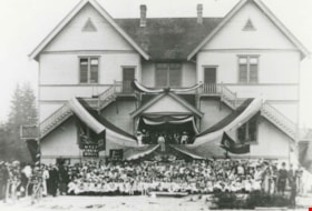
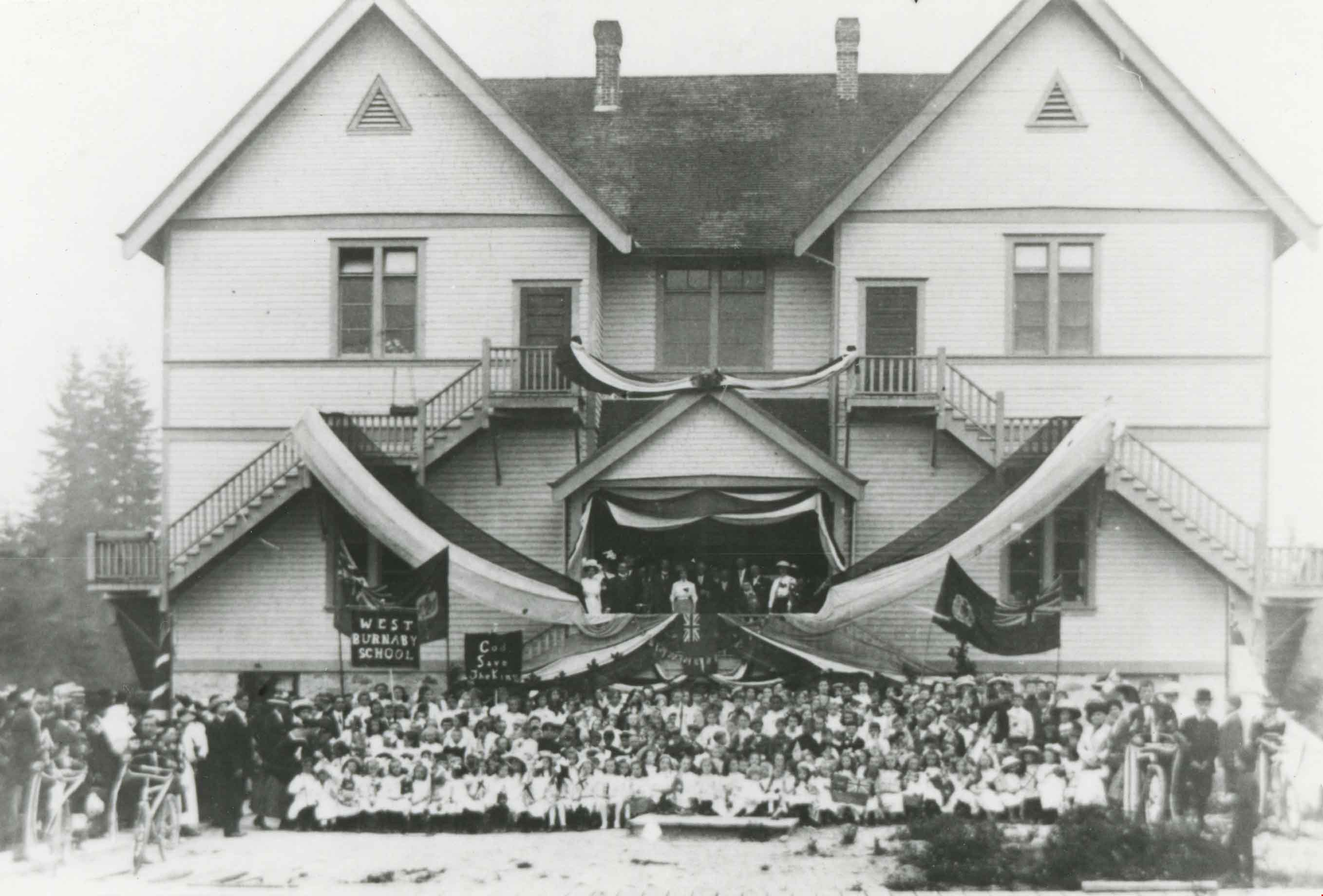
- Scope and Content
- Photograph of a "Coronation Day" celebration at Edmonds Street School, June 24, 1911. All Burnaby schools were included. Children are posed outside of the school with decorations and banners.
- Repository
- City of Burnaby Archives
- Date
- June 11, 1911 (date of original), copied 1985
- Collection/Fonds
- Burnaby Historical Society fonds
- Subseries
- Lewis family subseries
- Physical Description
- 1 photograph : b&w ; 8.8 x 12.5 cm print
- Description Level
- Item
- Record No.
- 140-006
- Access Restriction
- No restrictions
- Reproduction Restriction
- No known restrictions
- Accession Number
- BHS1985-10
- Scope and Content
- Photograph of a "Coronation Day" celebration at Edmonds Street School, June 24, 1911. All Burnaby schools were included. Children are posed outside of the school with decorations and banners.
- Subjects
- Celebrations
- Buildings - Schools
- Names
- Edmonds Community School
- Media Type
- Photograph
- Notes
- Title based on contents of photograph
- The photographer identified as "Brown" was located in New Westminster
- Geographic Access
- Edmonds Street
- Street Address
- 7641 Edmonds Street
- Historic Neighbourhood
- Edmonds (Historic Neighbourhood)
- Planning Study Area
- Edmonds Area
Images
![Edmonds Street School, [between 1911 and 1919] thumbnail](/media/hpo/_Data/_Archives_Images/_Unrestricted/316/325-039.jpg?width=280)
Edmonds Street School
https://search.heritageburnaby.ca/link/archivedescription37167
- Repository
- City of Burnaby Archives
- Date
- [between 1911 and 1919]
- Collection/Fonds
- Burnaby Historical Society fonds
- Description Level
- Item
- Physical Description
- 1 photograph : b&w ; 8.5 x 12.5 cm print
- Scope and Content
- Photograph of Edmonds Street School and surrounding area.
- Repository
- City of Burnaby Archives
- Date
- [between 1911 and 1919]
- Collection/Fonds
- Burnaby Historical Society fonds
- Subseries
- Disney family subseries
- Physical Description
- 1 photograph : b&w ; 8.5 x 12.5 cm print
- Description Level
- Item
- Record No.
- 325-039
- Access Restriction
- No restrictions
- Reproduction Restriction
- No known restrictions
- Accession Number
- BHS1996-04
- Scope and Content
- Photograph of Edmonds Street School and surrounding area.
- Subjects
- Buildings - Schools
- Names
- Edmonds Community School
- Media Type
- Photograph
- Photographer
- Disney, John Harold "Jack"
- Notes
- Title based on contents of photograph
- Geographic Access
- Edmonds Street
- Street Address
- 7641 Edmonds Street
- Historic Neighbourhood
- Edmonds (Historic Neighbourhood)
- Planning Study Area
- Edmonds Area
Images
![Edmonds Street School, [between 1911 and 1919] thumbnail](/media/hpo/_Data/_Archives_Images/_Unrestricted/316/325-039.jpg)
![Edmonds Street School, [1914] thumbnail](/media/hpo/_Data/_BVM_Images/1971/197200110011.jpg?width=280)
Edmonds Street School
https://search.heritageburnaby.ca/link/museumdescription3097
- Repository
- Burnaby Village Museum
- Date
- [1914]
- Collection/Fonds
- Burnaby Village Museum Photograph collection
- Description Level
- Item
- Physical Description
- 1 photograph : b&w glass negative ; 15.8 x 21.1 cm
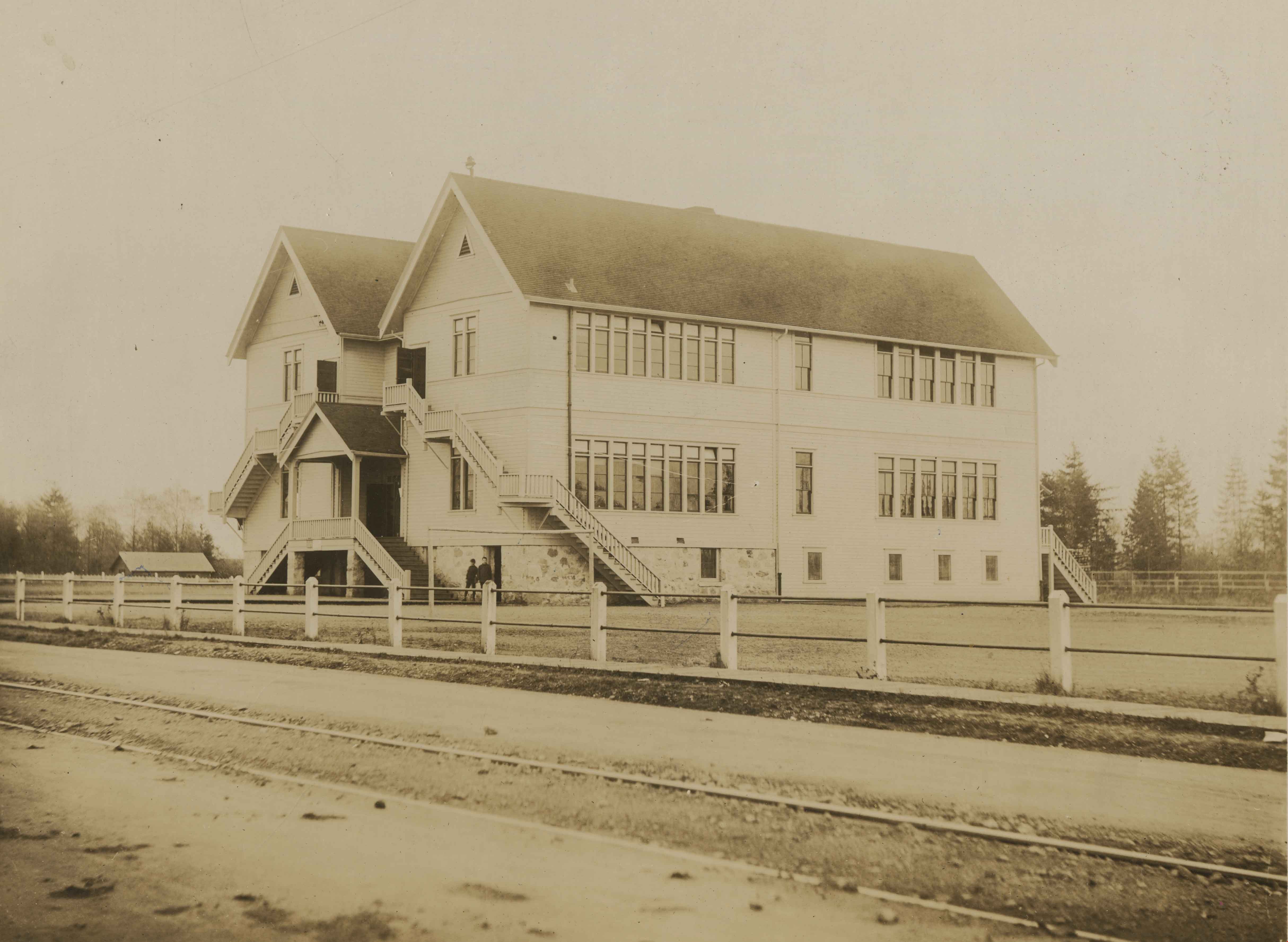
- Scope and Content
- Photograph of the newly built Edmonds Street school building standing by street car tracks. An earlier record from 1988 notes that the Edmonds Street School building was built between 1908 and 1912 in three sections. The record notes that in background across Douglas Road (now Canada Way) is the sm…
- Repository
- Burnaby Village Museum
- Collection/Fonds
- Burnaby Village Museum Photograph collection
- Description Level
- Item
- Physical Description
- 1 photograph : b&w glass negative ; 15.8 x 21.1 cm
- Scope and Content
- Photograph of the newly built Edmonds Street school building standing by street car tracks. An earlier record from 1988 notes that the Edmonds Street School building was built between 1908 and 1912 in three sections. The record notes that in background across Douglas Road (now Canada Way) is the small hall on the grounds of St. Albans church. The record dates the negative ca. 1914.
- Subjects
- Buildings - Schools
- Names
- Edmonds Community School
- Geographic Access
- Edmonds Street
- Street Address
- 7641 Edmonds Street
- Accession Code
- HV972.11.11
- Access Restriction
- No restrictions
- Reproduction Restriction
- No known restrictions
- Date
- [1914]
- Media Type
- Photograph
- Historic Neighbourhood
- Edmonds (Historic Neighbourhood)
- Planning Study Area
- Edmonds Area
- Related Material
- For another view of the same school building, see HV972.11.12
- Scan Resolution
- 300
- Scan Date
- 14/8/2006
- Scale
- 100
- Notes
- Title based on contents of photograph
- 1 b&w contact print accompanying negative
Images
![Edmonds Street School, [1914] thumbnail](/media/hpo/_Data/_BVM_Images/1971/197200110011.jpg)
![Edmonds Street School, [1914] thumbnail](/media/hpo/_Data/_BVM_Images/1971/197200110012.jpg?width=280)
Edmonds Street School
https://search.heritageburnaby.ca/link/museumdescription3098
- Repository
- Burnaby Village Museum
- Date
- [1914]
- Collection/Fonds
- Burnaby Village Museum Photograph collection
- Description Level
- Item
- Physical Description
- 1 photograph : b&w glass negative ; 15.8 x 21.1 cm
- Scope and Content
- Photograph of the Edmonds school building by the street car tracks. A teacher is standing by the door facing the tracks and students seem to be entering the school. The Edmonds Street School building was built between 1908 and 1912 in three sections. The record dates the negative ca. 1914.
- Repository
- Burnaby Village Museum
- Collection/Fonds
- Burnaby Village Museum Photograph collection
- Description Level
- Item
- Physical Description
- 1 photograph : b&w glass negative ; 15.8 x 21.1 cm
- Scope and Content
- Photograph of the Edmonds school building by the street car tracks. A teacher is standing by the door facing the tracks and students seem to be entering the school. The Edmonds Street School building was built between 1908 and 1912 in three sections. The record dates the negative ca. 1914.
- Subjects
- Buildings - Schools
- Names
- Edmonds Community School
- Geographic Access
- Edmonds Street
- Street Address
- 7641 Edmonds Street
- Accession Code
- HV972.11.12
- Access Restriction
- No restrictions
- Reproduction Restriction
- No known restrictions
- Date
- [1914]
- Media Type
- Photograph
- Historic Neighbourhood
- Edmonds (Historic Neighbourhood)
- Planning Study Area
- Edmonds Area
- Related Material
- For another view of the same school building, see HV972.11.11
- Scan Resolution
- 600
- Scan Date
- 17-Dec-2019
- Scale
- 100
- Notes
- Title based on contents of photograph
- 1 b&w contact print accompanying negative
Images
![Edmonds Street School, [1914] thumbnail](/media/hpo/_Data/_BVM_Images/1971/197200110012.jpg)

Edmonds Street School site
https://search.heritageburnaby.ca/link/museumdescription11125
- Repository
- Burnaby Village Museum
- Date
- March 8, 1915
- Collection/Fonds
- Ronald G. Scobbie collection
- Description Level
- Item
- Physical Description
- 1 survey plan : blueprint on paper ; 56 x 54 cm
- Scope and Content
- Survey plan of "Edmonds Street School Site" "Burnaby Municipality" "Being Lots 28 and 29 of the Subdivision of Lot 30, Group 1, New Westminster District";
- Repository
- Burnaby Village Museum
- Collection/Fonds
- Ronald G. Scobbie collection
- Description Level
- Item
- Physical Description
- 1 survey plan : blueprint on paper ; 56 x 54 cm
- Material Details
- Scale: 4 feet = 1 inch
- Scope and Content
- Survey plan of "Edmonds Street School Site" "Burnaby Municipality" "Being Lots 28 and 29 of the Subdivision of Lot 30, Group 1, New Westminster District";
- Subjects
- Buildings - Schools
- Names
- Edmonds Community School
- Responsibility
- Burnett and McGugan B.C. Land Surveyors, New Westminster
- Geographic Access
- Edmonds Street
- Street Address
- 7641 Edmonds Street
- Accession Code
- BV003.83.5
- Access Restriction
- No restrictions
- Reproduction Restriction
- No known restrictions
- Date
- March 8, 1915
- Media Type
- Cartographic Material
- Historic Neighbourhood
- Edmonds (Historic Neighbourhood)
- Planning Study Area
- Edmonds Area
- Scan Resolution
- 440
- Scan Date
- 22-Dec-2020
- Scale
- 100
- Notes
- Title based on contents of plan
- Oath in bottom left corner reads: "I, D.J. McGugan...and did personally superintend the survey..." "...completed on the 8th day of March 1915"; signed "D.J. McGugan", notarized by "S.F. Mark" "sworn...12th Day of April 1915"
- handwritten on back, "1756"
Zoomable Images

![Gilmore Avenue School, [1917 or 1918] (date of original), copied 1991 thumbnail](/media/hpo/_Data/_Archives_Images/_Unrestricted/370/370-779.jpg?width=280)
Gilmore Avenue School
https://search.heritageburnaby.ca/link/archivedescription38192
- Repository
- City of Burnaby Archives
- Date
- [1917 or 1918] (date of original), copied 1991
- Collection/Fonds
- Burnaby Historical Society fonds
- Description Level
- Item
- Physical Description
- 1 photograph : b&w ; 3.2 x 4.6 cm print on contact sheet 20.4 x 26.5 cm
- Scope and Content
- Photograph of the original Gilmore Avenue School.
- Repository
- City of Burnaby Archives
- Date
- [1917 or 1918] (date of original), copied 1991
- Collection/Fonds
- Burnaby Historical Society fonds
- Subseries
- Burnaby Image Bank subseries
- Physical Description
- 1 photograph : b&w ; 3.2 x 4.6 cm print on contact sheet 20.4 x 26.5 cm
- Description Level
- Item
- Record No.
- 370-779
- Access Restriction
- No restrictions
- Reproduction Restriction
- No known restrictions
- Accession Number
- BHS1999-03
- Scope and Content
- Photograph of the original Gilmore Avenue School.
- Subjects
- Buildings - Schools
- Names
- Gilmore Avenue School
- Media Type
- Photograph
- Notes
- Title based on contents of photograph
- 1 b&w copy negative accompanying
- Negative has a pink cast
- Geographic Access
- Gilmore Avenue
- Street Address
- 50 Gilmore Avenue
- Historic Neighbourhood
- Vancouver Heights (Historic Neighbourhood)
- Planning Study Area
- Burnaby Heights Area
Images
![Gilmore Avenue School, [1917 or 1918] (date of original), copied 1991 thumbnail](/media/hpo/_Data/_Archives_Images/_Unrestricted/370/370-779.jpg)
![Gilmore Avenue School, [1916] thumbnail](/media/hpo/_Data/_Archives_Images/_Unrestricted/371/449-004.jpg?width=280)
Gilmore Avenue School
https://search.heritageburnaby.ca/link/archivedescription38509
- Repository
- City of Burnaby Archives
- Date
- [1916]
- Collection/Fonds
- Burnaby Historical Society fonds
- Description Level
- Item
- Physical Description
- 1 photograph : sepia postcard ; 9 x 14 cm
- Scope and Content
- Photographic postcard of the Gilmore Avenue School building with a few children standing on the front step (all unidentified). Written on the bottom right of the postcard is; "Gilmore Avenue School, Vancouver Heights, Vancouver BC." At the bottom left, the photographer is identified as J.M. Henton…
- Repository
- City of Burnaby Archives
- Date
- [1916]
- Collection/Fonds
- Burnaby Historical Society fonds
- Subseries
- Photographs subseries
- Physical Description
- 1 photograph : sepia postcard ; 9 x 14 cm
- Description Level
- Item
- Record No.
- 449-004
- Access Restriction
- No restrictions
- Reproduction Restriction
- No known restrictions
- Accession Number
- BHS2007-04
- Scope and Content
- Photographic postcard of the Gilmore Avenue School building with a few children standing on the front step (all unidentified). Written on the bottom right of the postcard is; "Gilmore Avenue School, Vancouver Heights, Vancouver BC." At the bottom left, the photographer is identified as J.M. Henton, Vancouver.
- Names
- Gilmore Avenue School
- Media Type
- Photograph
- Photographer
- Henton, J.M.
- Geographic Access
- Gilmore Avenue
- Street Address
- 50 Gilmore Avenue
- Historic Neighbourhood
- Vancouver Heights (Historic Neighbourhood)
- Planning Study Area
- Burnaby Heights Area
Images
![Gilmore Avenue School, [1916] thumbnail](/media/hpo/_Data/_Archives_Images/_Unrestricted/371/449-004.jpg)
![Gilmore Avenue School, [1915] thumbnail](/media/hpo/_Data/_BVM_Images/1985/1985_0100_0002_001.jpg?width=280)
Gilmore Avenue School
https://search.heritageburnaby.ca/link/museumdescription2990
- Repository
- Burnaby Village Museum
- Date
- [1915]
- Collection/Fonds
- Burnaby Village Museum Photograph collection
- Description Level
- Item
- Physical Description
- 1 photograph : b&w postcard ; 8.9 x 13.8 cm
- Scope and Content
- Photographic postcard of the front of the Gilmore Avenue School ca. 1915. Children are visible in and around the school. Annotations on the back of the postcard reads: :"Mr. Geoge Smith" and "Gilmore School. / 1915." Stamped on the back of the postcard: "Gilmore Avenue School / 50 Gilmore Avenue /…
- Repository
- Burnaby Village Museum
- Collection/Fonds
- Burnaby Village Museum Photograph collection
- Description Level
- Item
- Physical Description
- 1 photograph : b&w postcard ; 8.9 x 13.8 cm
- Scope and Content
- Photographic postcard of the front of the Gilmore Avenue School ca. 1915. Children are visible in and around the school. Annotations on the back of the postcard reads: :"Mr. Geoge Smith" and "Gilmore School. / 1915." Stamped on the back of the postcard: "Gilmore Avenue School / 50 Gilmore Avenue / Burnaby 2. B.C."
- Names
- Gilmore Avenue School
- Geographic Access
- Gilmore Avenue
- Street Address
- 50 Gilmore Avenue
- Accession Code
- BV985.100.2
- Access Restriction
- No restrictions
- Reproduction Restriction
- No known restrictions
- Date
- [1915]
- Media Type
- Photograph
- Historic Neighbourhood
- Vancouver Heights (Historic Neighbourhood)
- Planning Study Area
- Burnaby Heights Area
- Scan Resolution
- 600
- Scan Date
- 2024-02-02
- Notes
- Title based on contents of photograph
Images
![Gilmore Avenue School, [1915] thumbnail](/media/hpo/_Data/_BVM_Images/1985/1985_0100_0002_001.jpg)