More like 'Don Brown at Bonsor'
Narrow Results By
Decade
- 2020s 149
- 2010s 141
- 2000s 1254
- 1990s 1199
- 1980s 827
- 1970s 1421
- 1960s 520
- 1950s 632
- 1940s 686
- 1930s 735
- 1920s 833
- 1910s 797
- 1900s 308
- 1890s 40
- 1880s 70
- 1870s 5
- 1860s 3
- 1850s 1
- 1840s 1
- 1830s 1
- 1820s 1
- 1810s 1
- 1800s 1
- 1790s 1
- 1780s 1
- 1770s 1
- 1760s 1
- 1750s 1
- 1740s 1
- 1730s 1
- 1720s 1
- 1710s 1
- 1700s 1
- 1690s 1
- 1680s 1
- 1670s 1
- 1660s 1
- 1650s 1
- 1640s 1
- 1630s 1
- 1620s 1
- 1610s 1
- 1600s 1
Subject
- Accidents 1
- Accidents - Automobile Accidents 2
- Adornment 15
- Adornment - Lapel Pins 15
- Advertising Medium 13
- Advertising Medium - Flyer 6
- Advertising Medium - Signs and Signboards 133
- Aerial Photographs 59
- Agricultural Tools and Equipment 2
- Agricultural Tools and Equipment - Gardening Equipment 4
- Agricultural Tools and Equipment - Plows 5
- Agriculture 7
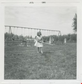
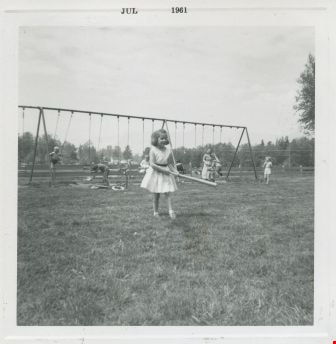
Louise Emmonds at Deer lake
https://search.heritageburnaby.ca/link/archivedescription52979
- Repository
- City of Burnaby Archives
- Date
- July 1961
- Collection/Fonds
- Burnaby Historical Society fonds
- Description Level
- Item
- Physical Description
- 1 photograph : b&w ; 7.5 x 7.5 cm, mounted on heavy-weight paper 17.5 x 27.5 cm
- Scope and Content
- Photograph of Louise Emmonds swinging a bat at Dear lake. She is wearing a white dress with a black belt. Children can be seen swinging on a large swing set (with the help of adults) in the background.
- Repository
- City of Burnaby Archives
- Date
- July 1961
- Collection/Fonds
- Burnaby Historical Society fonds
- Subseries
- Tinkerbell Kindergarten subseries
- Physical Description
- 1 photograph : b&w ; 7.5 x 7.5 cm, mounted on heavy-weight paper 17.5 x 27.5 cm
- Description Level
- Item
- Record No.
- 246-019
- Access Restriction
- No restrictions
- Reproduction Restriction
- Reproduce for fair dealing purposes only
- Accession Number
- BHS1990-12
- Scope and Content
- Photograph of Louise Emmonds swinging a bat at Dear lake. She is wearing a white dress with a black belt. Children can be seen swinging on a large swing set (with the help of adults) in the background.
- Media Type
- Photograph
- Notes
- Title based on contents of photograph
- Handwritten note on paper mount reads: "Deer Lake / 1960 - 1961 / mis [sic] Louise Emmonds"
- Geographic Access
- Deer Lake
- Deer Lake Park
- Deer Lake Avenue
- Historic Neighbourhood
- Burnaby Lake (Historic Neighbourhood)
- Planning Study Area
- Douglas-Gilpin Area
Images
![Shirley Fisher, [2000] thumbnail](/media/hpo/_Data/_Archives_Images/_Unrestricted/535/535-2109-1.jpg?width=280)
Shirley Fisher
https://search.heritageburnaby.ca/link/archivedescription96485
- Repository
- City of Burnaby Archives
- Date
- [2000]
- Collection/Fonds
- Burnaby NewsLeader photograph collection
- Description Level
- File
- Physical Description
- 2 photographs (tiff) : col.
- Scope and Content
- File contains photographs of Shirley Fisher, who formerly ran the boat rental concession at the Deer Lake Park beach, preparing to cycle across Canada. Photographs depict Fisher posing with her bicycle on the beach at Deer Lake and looking at a photograph album in the canoe rental shed at Deer Lake.
- Repository
- City of Burnaby Archives
- Date
- [2000]
- Collection/Fonds
- Burnaby NewsLeader photograph collection
- Physical Description
- 2 photographs (tiff) : col.
- Description Level
- File
- Record No.
- 535-2109
- Access Restriction
- No restrictions
- Reproduction Restriction
- No restrictions
- Accession Number
- 2018-12
- Scope and Content
- File contains photographs of Shirley Fisher, who formerly ran the boat rental concession at the Deer Lake Park beach, preparing to cycle across Canada. Photographs depict Fisher posing with her bicycle on the beach at Deer Lake and looking at a photograph album in the canoe rental shed at Deer Lake.
- Names
- Fisher, Shirley
- Media Type
- Photograph
- Photographer
- Bartel, Mario
- Notes
- Title based on caption
- Collected by editorial for use in a March 2000 issue of the Burnaby NewsLeader
- Caption from metadata for 535-2109-1: "Shirley Fisher is preparing to cycle across Canada, after retiring from her job running the boat rental concession at Deer Lake."
- Caption from metadata for 535-2109-2: "Shirley Fisher leafs through a photo album of memories of her years running the canoe rental shed at Deer Lake. She's retiring to pursue her dream of cycling across Canada."
- Geographic Access
- Deer Lake Park
- Deer Lake
- Historic Neighbourhood
- Burnaby Lake (Historic Neighbourhood)
- Planning Study Area
- Morley-Buckingham Area
Images
![Shirley Fisher, [2000] thumbnail](/media/hpo/_Data/_Archives_Images/_Unrestricted/535/535-2109-1.jpg)
![Swimming in Deer Lake, [1905] thumbnail](/media/hpo/_Data/_Archives_Images/_Unrestricted/477/477-110.jpg?width=280)
Swimming in Deer Lake
https://search.heritageburnaby.ca/link/archivedescription38791
- Repository
- City of Burnaby Archives
- Date
- [1905]
- Collection/Fonds
- Peers Family and Hill Family fonds
- Description Level
- Item
- Physical Description
- 1 photograph : b&w ; 5.5 x 5.5 cm on page 11.5 x 14 cm (pasted in album)
- Scope and Content
- Photograph of a boat in the foreground and a number of people swimming in Deer Lake.
- Repository
- City of Burnaby Archives
- Date
- [1905]
- Collection/Fonds
- Peers Family and Hill Family fonds
- Physical Description
- 1 photograph : b&w ; 5.5 x 5.5 cm on page 11.5 x 14 cm (pasted in album)
- Description Level
- Item
- Record No.
- 477-110
- Access Restriction
- No restrictions
- Reproduction Restriction
- No known restrictions
- Accession Number
- 2007-12
- Scope and Content
- Photograph of a boat in the foreground and a number of people swimming in Deer Lake.
- Media Type
- Photograph
- Notes
- Title based on contents of photograph
- Geographic Access
- Deer Lake
- Historic Neighbourhood
- Burnaby Lake (Historic Neighbourhood)
Images
![Swimming in Deer Lake, [1905] thumbnail](/media/hpo/_Data/_Archives_Images/_Unrestricted/477/477-110.jpg)
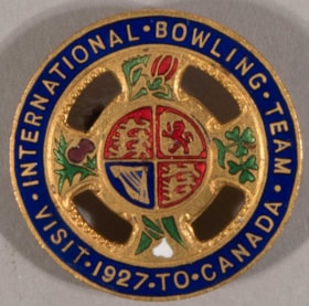
lapel pin
https://search.heritageburnaby.ca/link/museumartifact6645
- Repository
- Burnaby Village Museum
- Accession Code
- BV985.97.3
- Description
- Pin, round, enamelled brass. Wide blue border around outside with thin gold edges and gold lettering "INTERNATIONAL. BOWLING. TEAM. / VISIT. 1927. TO. CANADA". Inner part of pin is cruciform, with round centre connected to outer edge with four arms, open cut-out areas between. Each arm shows a coloured enamel floral symbol. At top is the rose, at right are shamrocks, at bottom is the lily, at left is the thistle. At the centre of the pin is the Royal Coat of Arms of the United Kingdom in red and blue with gold. Locking pin back on reverse, open loop. "R. SCOTT / GLASGOW" in raised letters near bottom edge. Some discolouration on back, very slight wear on front.
- Category
- 08. Communication Artifacts
- Classification
- Documentary Artifacts - - Memorabilia
- Object Term
- Commemorative
- Marks/Labels
- "INTERNATIONAL BOWLING TEAM", embossed gold lettering in half circle along top of pin "VISIT 1927 TO CANADA", embossed gold lettering in half circle along bottom of pin
- Measurements
- Dia: 2.9 cm
- Country Made
- Scotland
- Site/City Made
- Glasgow
- Subjects
- Adornment
- Adornment - Lapel Pins
- Advertising Medium
- Events - Competitions
- Organizations - Athletic Associations
- Sports - Bowling
Images


Burnaby Lake Sign (Nature House)
https://search.heritageburnaby.ca/link/archivedescription93629
- Repository
- City of Burnaby Archives
- Date
- October 22, 1977
- Collection/Fonds
- Burnaby Public Library Contemporary Visual Archive Project
- Description Level
- Item
- Physical Description
- 1 photograph : b&w ; 12.5 x 17.5 cm
- Scope and Content
- Photograph of the sign welcoming the public to the Nature House and Burnaby Lake. The sign depicts a map of Burnaby Lake and points of interest, including the rowing complex, pool, ice rink, and Old Mill Site. A smaller sign shows the address of 4519 Piper and a small footbridge is in the backgroun…
- Repository
- City of Burnaby Archives
- Date
- October 22, 1977
- Collection/Fonds
- Burnaby Public Library Contemporary Visual Archive Project
- Physical Description
- 1 photograph : b&w ; 12.5 x 17.5 cm
- Description Level
- Item
- Record No.
- 556-586
- Access Restriction
- No restrictions
- Reproduction Restriction
- Reproduce for fair dealing purposes only
- Accession Number
- 2017-57
- Scope and Content
- Photograph of the sign welcoming the public to the Nature House and Burnaby Lake. The sign depicts a map of Burnaby Lake and points of interest, including the rowing complex, pool, ice rink, and Old Mill Site. A smaller sign shows the address of 4519 Piper and a small footbridge is in the background. The photograph is taken facing southwest.
- Media Type
- Photograph
- Photographer
- Surridge, Jack
- Notes
- Title taken from project information form
- Accompanied by a project information form and 1 photograph (b&w negative ; 9.5 x 12.5 cm)
- BPL no. 35
- Geographic Access
- Burnaby Lake Regional Nature Park
- Street Address
- 4519 Piper Avenue
- Historic Neighbourhood
- Lozells (Historic Neighbourhood)
- Planning Study Area
- Burnaby Lake Area
Images


Kingsway
https://search.heritageburnaby.ca/link/archivedescription35874
- Repository
- City of Burnaby Archives
- Date
- 1900 (date of original), copied 1986
- Collection/Fonds
- Burnaby Historical Society fonds
- Description Level
- Item
- Physical Description
- 1 photograph : b&w ; 12.7 x 17.8 cm print
- Scope and Content
- Photograph of Kingsway (then Westminster Road), looking east from Boundary Road near Central Park. Included in the photograph; Central Park Presbyterian Church, Masonic Hall and Reid's Hall.
- Repository
- City of Burnaby Archives
- Date
- 1900 (date of original), copied 1986
- Collection/Fonds
- Burnaby Historical Society fonds
- Subseries
- Pioneer Tales subseries
- Physical Description
- 1 photograph : b&w ; 12.7 x 17.8 cm print
- Description Level
- Item
- Record No.
- 204-733
- Access Restriction
- No restrictions
- Reproduction Restriction
- No known restrictions
- Accession Number
- BHS1988-03
- Scope and Content
- Photograph of Kingsway (then Westminster Road), looking east from Boundary Road near Central Park. Included in the photograph; Central Park Presbyterian Church, Masonic Hall and Reid's Hall.
- Subjects
- Buildings - Recreational - Community Halls
- Buildings - Religious - Churches
- Geographic Features - Roads
- Media Type
- Photograph
- Notes
- Title based on contents of photograph
- Geographic Access
- Westminster Avenue
- Kingsway
- Street Address
- 3777 Kingsway
- Historic Neighbourhood
- Central Park (Historic Neighbourhood)
- Planning Study Area
- Garden Village Area
Images


Nature House
https://search.heritageburnaby.ca/link/archivedescription93628
- Repository
- City of Burnaby Archives
- Date
- October 22, 1977
- Collection/Fonds
- Burnaby Public Library Contemporary Visual Archive Project
- Description Level
- Item
- Physical Description
- 1 photograph : b&w ; 12.5 x 17.5 cm
- Scope and Content
- Photograph of the Burnaby Lake Nature House at 4519 Piper Avenue in Burnaby Lake Regional Park. The photograph is taken facing southwest. The Nature House was built in 1940. The sign for the Nature House is just visible on the left side of the photograph, and canoes are stacked outside beside the b…
- Repository
- City of Burnaby Archives
- Date
- October 22, 1977
- Collection/Fonds
- Burnaby Public Library Contemporary Visual Archive Project
- Physical Description
- 1 photograph : b&w ; 12.5 x 17.5 cm
- Description Level
- Item
- Record No.
- 556-585
- Access Restriction
- No restrictions
- Reproduction Restriction
- Reproduce for fair dealing purposes only
- Accession Number
- 2017-57
- Scope and Content
- Photograph of the Burnaby Lake Nature House at 4519 Piper Avenue in Burnaby Lake Regional Park. The photograph is taken facing southwest. The Nature House was built in 1940. The sign for the Nature House is just visible on the left side of the photograph, and canoes are stacked outside beside the building.
- Media Type
- Photograph
- Photographer
- Surridge, Jack
- Notes
- Title taken from project information form
- Accompanied by a project information form and 1 photograph (b&w negative ; 9.5 x 12.5 cm)
- BPL no. 34
- Geographic Access
- Burnaby Lake Regional Nature Park
- Street Address
- 4519 Piper Avenue
- Historic Neighbourhood
- Lozells (Historic Neighbourhood)
- Planning Study Area
- Burnaby Lake Area
Images


Welcome back to Bonsor
https://search.heritageburnaby.ca/link/museumdescription15387
- Repository
- Burnaby Village Museum
- Date
- September 2020
- Collection/Fonds
- Burnaby Village Museum COVID-19 collection
- Description Level
- Item
- Physical Description
- 1 video recording (mp4) (2 min., 31 sec.) : digital, 24 fps, col., sd., stereo
- Scope and Content
- City of Burnaby film welcoming the public back to Bonsor Recreation Complex after it was closed following public health restrictions in the spring of 2020. The film provides information to the public regarding the new procedures and protocols that were put in place and how they will be operating at…
- Repository
- Burnaby Village Museum
- Collection/Fonds
- Burnaby Village Museum COVID-19 collection
- Description Level
- Item
- Physical Description
- 1 video recording (mp4) (2 min., 31 sec.) : digital, 24 fps, col., sd., stereo
- Scope and Content
- City of Burnaby film welcoming the public back to Bonsor Recreation Complex after it was closed following public health restrictions in the spring of 2020. The film provides information to the public regarding the new procedures and protocols that were put in place and how they will be operating at a reduced capacity to allow for physical distancing and enhanced cleaning.
- History
- Video taken by the City of Burnaby Marketing Department in 2020. The original intent of the clip was to produce communications about the pandemic and changes throughout the City that residents needed to be aware of.
- Creator
- City of Burnaby
- Subjects
- Buildings - Recreational
- Buildings - Recreational - Sports
- Buildings - Recreational - Swimming Pools
- Buildings - Civic - Community Centres
- Public Services - Municipal Services
- Pandemics - COVID-19
- Geographic Access
- Bonsor Avenue
- Street Address
- 6550 Bonsor Avenue
- Accession Code
- BV021.2.4
- Access Restriction
- No restrictions
- Reproduction Restriction
- May be restricted by third party rights
- Date
- September 2020
- Media Type
- Moving Images
- Historic Neighbourhood
- Central Park (Historic Neighbourhood)
- Planning Study Area
- Marlborough Area
- Notes
- Title based on contents of film
Images

Video
Welcome back to Bonsor, September 2020
Welcome back to Bonsor, September 2020
https://search.heritageburnaby.ca/media/hpo/_Data/_BVM_Moving_Images/2021_0002_0004_001.mp4
Andy's first film
https://search.heritageburnaby.ca/link/archivedescription85207
- Repository
- City of Burnaby Archives
- Date
- 1934
- Collection/Fonds
- Digney Family fonds
- Description Level
- Item
- Physical Description
- 1 film clip (10 min., 3 sec.) : digital, b&w, col., si.
- Scope and Content
- Item is a silent digitized (DVD) film segment with footage identified as 'Reel 1' . Film footage flucuates between black and white and colour providing a look into activities of Andy Digney and his family while they resided in Brandon, Manitoba. Footage documents outdoor activities such as camping…
- Repository
- City of Burnaby Archives
- Date
- 1934
- Collection/Fonds
- Digney Family fonds
- Physical Description
- 1 film clip (10 min., 3 sec.) : digital, b&w, col., si.
- Description Level
- Item
- Record No.
- 562-003-1
- Access Restriction
- No restrictions
- Reproduction Restriction
- May be restricted by third party rights
- Accession Number
- 2014-04
- Scope and Content
- Item is a silent digitized (DVD) film segment with footage identified as 'Reel 1' . Film footage flucuates between black and white and colour providing a look into activities of Andy Digney and his family while they resided in Brandon, Manitoba. Footage documents outdoor activities such as camping,fishing, boating, golfing, swimming, picnicing and a parade in Banff, Alberta.
- Subjects
- Animals - Dogs
- Recreational Activities - Fishing
- Recreational Activities - Camping
- Recreational Activities - Picnics
- Recreational Activities - Golf
- Geographic Features - Rivers
- Events - Parades
- Media Type
- Moving Images
- Photographer
- Digney, Andy
- Creator
- Digney, Andy
- Notes
- Title based on contents of film
Images
Video
Andy's first film, 1934

Adults and children at Deer Lake Park
https://search.heritageburnaby.ca/link/archivedescription59007
- Repository
- City of Burnaby Archives
- Date
- ca.1983
- Collection/Fonds
- Columbian Newspaper collection
- Description Level
- Item
- Physical Description
- 1 photograph : b&w ; 20.5 x 25.5 cm
- Scope and Content
- Photograph of adults and children having a picnic on the beach at Deer Lake Park.
- Repository
- City of Burnaby Archives
- Date
- ca.1983
- Collection/Fonds
- Columbian Newspaper collection
- Physical Description
- 1 photograph : b&w ; 20.5 x 25.5 cm
- Description Level
- Item
- Record No.
- 480-1416
- Access Restriction
- No restrictions
- Reproduction Restriction
- Reproduce for fair dealing purposes only
- Accession Number
- 2009-01
- Scope and Content
- Photograph of adults and children having a picnic on the beach at Deer Lake Park.
- Subjects
- Recreational Activities - Picnics
- Geographic Features - Lakes and Ponds
- Geographic Features - Beaches
- Persons - Children
- Media Type
- Photograph
- Photographer
- King, Basil
- Notes
- Title based on contents of photograph
- Photographer's stamp on verso
- Note on verso reads: "PMT 120% / page 10 / Burnaby / Today"
- Geographic Access
- Deer Lake Park
- Historic Neighbourhood
- Burnaby Lake (Historic Neighbourhood)
- Planning Study Area
- Douglas-Gilpin Area
Images

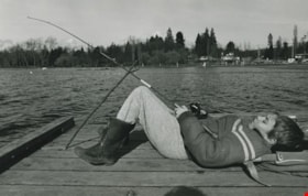
Boy fishing on a lake
https://search.heritageburnaby.ca/link/archivedescription59003
- Repository
- City of Burnaby Archives
- Date
- ca.1983
- Collection/Fonds
- Columbian Newspaper collection
- Description Level
- Item
- Physical Description
- 1 photograph : b&w ; 17 x 25.5 cm
- Scope and Content
- Photograph of a boy laying on a dock next to a lake; his fishing rod is propped up by a stick. A beach and playground are visible in the background.
- Repository
- City of Burnaby Archives
- Date
- ca.1983
- Collection/Fonds
- Columbian Newspaper collection
- Physical Description
- 1 photograph : b&w ; 17 x 25.5 cm
- Description Level
- Item
- Record No.
- 480-1412
- Access Restriction
- No restrictions
- Reproduction Restriction
- Reproduce for fair dealing purposes only
- Accession Number
- 2009-01
- Scope and Content
- Photograph of a boy laying on a dock next to a lake; his fishing rod is propped up by a stick. A beach and playground are visible in the background.
- Subjects
- Persons - Children
- Geographic Features - Lakes and Ponds
- Geographic Features - Beaches
- Recreational Activities - Fishing
- Media Type
- Photograph
- Photographer
- Hodge, Craig
- Notes
- Title based on contents of photograph
- Photographer's stamp on verso
- Note on verso reads: "PMT 76% / page A-4 / Burnaby Today"
Images

![Canoeing on Burnaby Lake, [1999] thumbnail](/media/hpo/_Data/_Archives_Images/_Unrestricted/535/535-3122.jpg?width=280)
Canoeing on Burnaby Lake
https://search.heritageburnaby.ca/link/archivedescription98042
- Repository
- City of Burnaby Archives
- Date
- [1999]
- Collection/Fonds
- Burnaby NewsLeader photograph collection
- Description Level
- Item
- Physical Description
- 1 photograph (tiff) : b&w
- Scope and Content
- Photograph of unidentified people canoeing on Burnaby Lake. Snow-covered mountains are visible in the background.
- Repository
- City of Burnaby Archives
- Date
- [1999]
- Collection/Fonds
- Burnaby NewsLeader photograph collection
- Physical Description
- 1 photograph (tiff) : b&w
- Description Level
- Item
- Record No.
- 535-3122
- Access Restriction
- No restrictions
- Reproduction Restriction
- No restrictions
- Accession Number
- 2018-12
- Scope and Content
- Photograph of unidentified people canoeing on Burnaby Lake. Snow-covered mountains are visible in the background.
- Subjects
- Recreational Activities - Canoeing
- Geographic Features - Lakes and Ponds
- Geographic Features - Mountains
- Media Type
- Photograph
- Notes
- Title based on contents of photograph
- Collected by editorial for use in a February 1999 issue of the Burnaby NewsLeader
- Geographic Access
- Burnaby Lake
- Historic Neighbourhood
- Burnaby Lake (Historic Neighbourhood)
- Planning Study Area
- Burnaby Lake Area
Images
![Canoeing on Burnaby Lake, [1999] thumbnail](/media/hpo/_Data/_Archives_Images/_Unrestricted/535/535-3122.jpg)

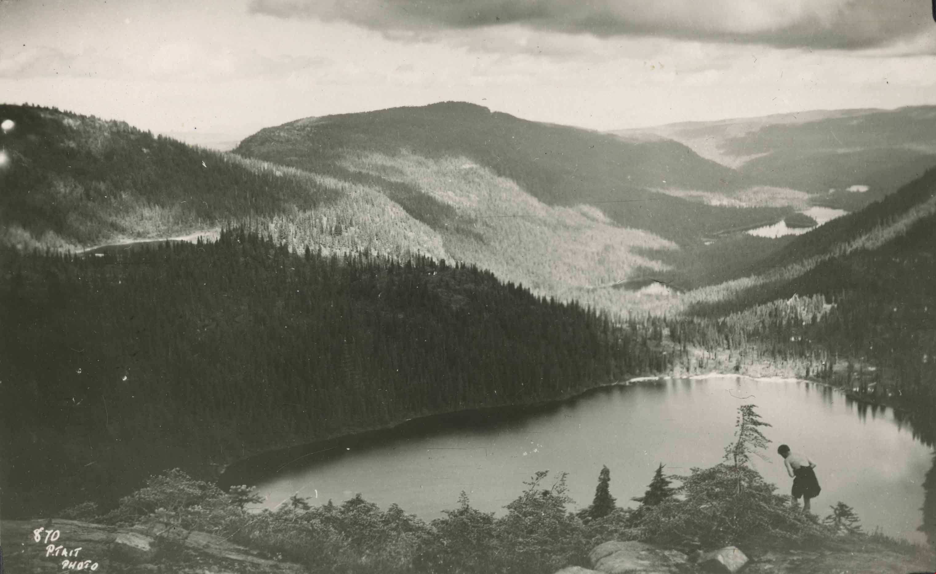
Circle Lake
https://search.heritageburnaby.ca/link/archivedescription51448
- Repository
- City of Burnaby Archives
- Date
- 1938
- Collection/Fonds
- Burnaby Historical Society fonds
- Description Level
- Item
- Physical Description
- 1 photograph : b&w postcard ; 8 x 13 cm, mounted on heavy-weight paper 17.5 x 26.5 cm
- Scope and Content
- Photographic postcard of Circle (Circlet) lake nestled among the mountains of the Forbidden Plateau on Vancouver Island, BC. A young man is making his way down Mount Albert Edward, towards the lake. This was part of a trip to the Forbidden Plateau made by a small party of City of Courtenay official…
- Repository
- City of Burnaby Archives
- Date
- 1938
- Collection/Fonds
- Burnaby Historical Society fonds
- Subseries
- George Grant subseries
- Physical Description
- 1 photograph : b&w postcard ; 8 x 13 cm, mounted on heavy-weight paper 17.5 x 26.5 cm
- Description Level
- Item
- Record No.
- 243-053
- Access Restriction
- No restrictions
- Reproduction Restriction
- No known restrictions
- Accession Number
- BHS1990-06
- Scope and Content
- Photographic postcard of Circle (Circlet) lake nestled among the mountains of the Forbidden Plateau on Vancouver Island, BC. A young man is making his way down Mount Albert Edward, towards the lake. This was part of a trip to the Forbidden Plateau made by a small party of City of Courtenay officials. George A. Grant was one of the climbers in the party.
- Subjects
- Geographic Features - Mountains
- Geographic Features - Lakes and Ponds
- Recreational Activities - Hiking
- Media Type
- Photograph
- Photographer
- Tait, Preston L.
- Notes
- Title taken from handwritten title on paper mount
- Handwritten note on on facing page reads: "Th' outstretching lake, embosomed' mong the hills / The eye with wonder and amazement fills / Burns"
- Photographer identifies photograph as no. 870
Images
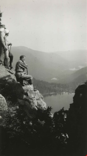
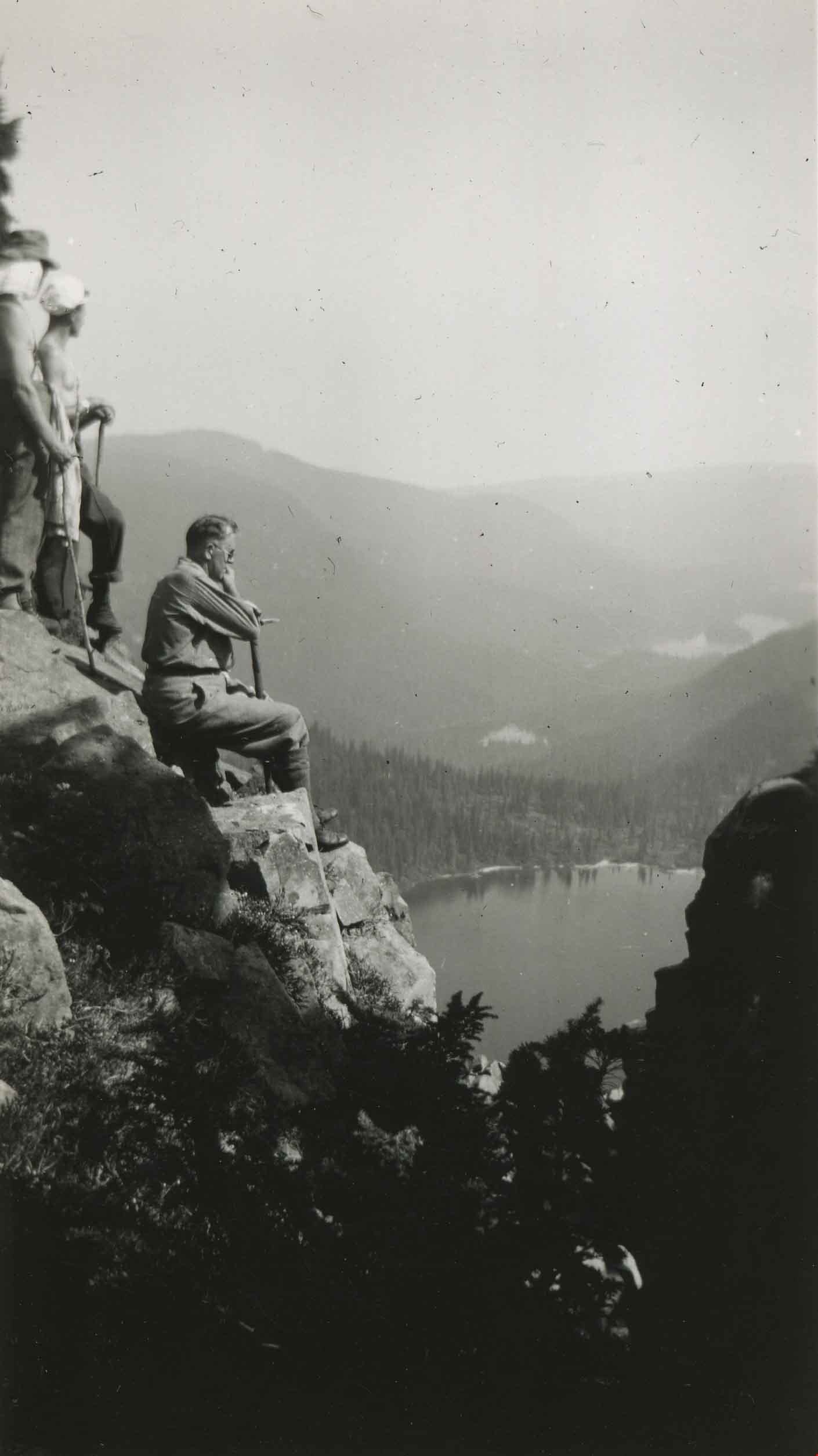
Contemplation
https://search.heritageburnaby.ca/link/archivedescription51449
- Repository
- City of Burnaby Archives
- Date
- August 19, 1938
- Collection/Fonds
- Burnaby Historical Society fonds
- Description Level
- Item
- Physical Description
- 1 photograph : b&w ; 10.5 x 6 cm, mounted on heavy-weight paper 17.5 x 26.5 cm
- Scope and Content
- Photograph of George A. Grant sitting on the rock face of Mount Albert Edward and admiring Circle (Circlet) Lake. Two men are standing just behind him. This was part of a trip to the Forbidden Plateau on Vancouver Island made by a small party of City of Courtenay officials.
- Repository
- City of Burnaby Archives
- Date
- August 19, 1938
- Collection/Fonds
- Burnaby Historical Society fonds
- Subseries
- George Grant subseries
- Physical Description
- 1 photograph : b&w ; 10.5 x 6 cm, mounted on heavy-weight paper 17.5 x 26.5 cm
- Description Level
- Item
- Record No.
- 243-054
- Access Restriction
- No restrictions
- Reproduction Restriction
- No known restrictions
- Accession Number
- BHS1990-06
- Scope and Content
- Photograph of George A. Grant sitting on the rock face of Mount Albert Edward and admiring Circle (Circlet) Lake. Two men are standing just behind him. This was part of a trip to the Forbidden Plateau on Vancouver Island made by a small party of City of Courtenay officials.
- Subjects
- Geographic Features - Mountains
- Geographic Features - Lakes and Ponds
- Recreational Activities - Hiking
- Media Type
- Photograph
- Notes
- Title taken from handwritten title on paper mount
- Handwritten note on facing page reads: "We pause on the Mount Abert [sic] Edward climb to admire Circle Lake and the rest."
- Stamp on verso of print reads: "Vancouver Drug Co. Ltd. AUG 19 1938 Nu-Gloss"
Images
![Fishing at Pitt Lake, [191-] thumbnail](/media/hpo/_Data/_BVM_Images/2022/2022_0032_0078_001.jpg?width=280)
Fishing at Pitt Lake
https://search.heritageburnaby.ca/link/museumdescription19656
- Repository
- Burnaby Village Museum
- Date
- [191-]
- Collection/Fonds
- Esther Love Stanley fonds
- Description Level
- Item
- Physical Description
- 1 photograph : b&w ; 8 x 9 cm
- Scope and Content
- Photograph of two men standing on a log while fishing at Pitt Lake. The men could be members of the Love or Stanley families.
- Repository
- Burnaby Village Museum
- Collection/Fonds
- Esther Love Stanley fonds
- Description Level
- Item
- Physical Description
- 1 photograph : b&w ; 8 x 9 cm
- Scope and Content
- Photograph of two men standing on a log while fishing at Pitt Lake. The men could be members of the Love or Stanley families.
- Subjects
- Recreational Activities - Fishing
- Geographic Features
- Geographic Features - Natural Waterways
- Accession Code
- BV022.32.78
- Access Restriction
- No restrictions
- Reproduction Restriction
- No known restrictions
- Date
- [191-]
- Media Type
- Photograph
- Scan Resolution
- 600
- Scan Date
- 2023-04-04
- Notes
- Title based on contents of photograph
- Photograph is part of Esther Love Stanley photograph album 1 (BV022.32.1)
Images
![Fishing at Pitt Lake, [191-] thumbnail](/media/hpo/_Data/_BVM_Images/2022/2022_0032_0078_001.jpg)
Interview with Alekxos Sarter by Kathy Bossort October 16, 2015 - Track 2
https://search.heritageburnaby.ca/link/oralhistory578
- Repository
- City of Burnaby Archives
- Date Range
- 1958-1992
- Length
- 0:12:40
- Summary
- This portion of the interview is about Alekxos Sarter’s first years of employment with Parks, her sources of knowledge about Burnaby Mountain, and the department’s activities in Burnaby Mountain Park. She talks about the loop trail planned for Burnaby Mountain Park in 1958, the Trans Canada Trail p…
- Repository
- City of Burnaby Archives
- Summary
- This portion of the interview is about Alekxos Sarter’s first years of employment with Parks, her sources of knowledge about Burnaby Mountain, and the department’s activities in Burnaby Mountain Park. She talks about the loop trail planned for Burnaby Mountain Park in 1958, the Trans Canada Trail project, events and issues at the Pavilion, and keeping track of trails on SFU lands.
- Date Range
- 1958-1992
- Length
- 0:12:40
- Names
- Burnaby Parks, Recreation and Cultural Services Department
- Burnaby Mountain Park
- Kamui Mintara
- Trans Canada Trail
- Geographic Access
- Burnaby Mountain Conservation Area
- Interviewer
- Bossort, Kathy
- Interview Date
- October 16, 2015
- Scope and Content
- Recording is of an interview with Alekxos Sarter conducted by Kathy Bossort. Alekxos Sarter was one of 23 participants interviewed as part of the Community Heritage Commission’s Burnaby Mountain Oral History Project. The interview is mainly about the history of setting aside parkland on Burnaby Mountain from Alekxos Sarter’s perspective and experience as employee in the City of Burnaby Parks, Recreation and Cultural Services. The interview provides an excellent explanation of the history and function of kinds of park dedications used by the City of Burnaby; an overview of issues around including the Trans Mountain tank farm in the conservation area; and the background to the land use and ownership disagreement between the City of Burnaby and Simon Fraser University, its resolution, and the subsequent development of SFU’s UniverCity. Alekxos Sarter talks about Richard Bolton, Burnaby’s Acting-Commissioner who was responsible for dedicating the first park on Burnaby Mountain in 1942, and the creation of a park named after him in UniverCity.
- Biographical Notes
- Alekxos Sarter was born in Vancouver in 1961, to Daine and Kasandra Sarter. She grew up in North Vancouver and since 1994 has lived on a sailboat in False Creek. After attending UBC where she studied landscape architecture, she was hired by the City of Burnaby Parks, Recreation and Cultural Services in 1986. Working first in parks design, Alekxos quickly moved into parks planning, her preferred career. As Research Officer she covers research, planning, public consultation, parks and facility inventory, parkland acquisition, among other duties.
- Total Tracks
- 9
- Total Length
- 2:20:47
- Interviewee Name
- Sarter, Alekxos T.
- Interview Location
- City of Burnaby Parks, Recreation and Cultural Services meeting room
- Interviewer Bio
- Kathy Bossort is a retired archivist living in Ladner, BC. She worked at the Delta Museum and Archives after graduating from SLAIS (UBC) in 2001 with Masters degrees in library science and archival studies. Kathy grew up in Calgary, Alberta, and, prior to this career change, she lived in the West Kootenays, earning her living as a cook for BC tourist lodges and work camps. She continues to be interested in oral histories as a way to fill the gaps in the written record and bring richer meaning to history.
- Collection/Fonds
- Community Heritage Commission Special Projects fonds
- Media Type
- Sound Recording
Audio Tracks
Track two of interview with Alekxos Sarter
Track two of interview with Alekxos Sarter
https://search.heritageburnaby.ca/media/hpo/_Data/_Archives_Oral_Histories/_Unrestricted/MSS196-005/MSS196-005_Track_2.mp3Interview with Henry deJong by Kathy Bossort November 6, 2015 - Track 2
https://search.heritageburnaby.ca/link/oralhistory610
- Repository
- City of Burnaby Archives
- Date Range
- 1995-2015
- Length
- 0:16:30
- Summary
- This portion of the interview is about Henry deJong’s explanation of how the 1999 Burnaby Mountain Conservation Area Plan guides work priorities in the conservation area. He gives a history of trail development since 2000, and describes how new trails are developed. He talks about discovering fish …
- Repository
- City of Burnaby Archives
- Summary
- This portion of the interview is about Henry deJong’s explanation of how the 1999 Burnaby Mountain Conservation Area Plan guides work priorities in the conservation area. He gives a history of trail development since 2000, and describes how new trails are developed. He talks about discovering fish in a tributary of Stoney Creek and closing trails to protect the area.
- Date Range
- 1995-2015
- Length
- 0:16:30
- Geographic Access
- Burnaby Mountain Conservation Area
- Interviewer
- Bossort, Kathy
- Interview Date
- November 6, 2015
- Scope and Content
- Recording is of an interview with Henry deJong conducted by Kathy Bossort. Henry deJong was one of 23 participants interviewed as part of the Community Heritage Commission’s Burnaby Mountain Oral History Project. The interview is mainly about Henry deJong’s work designing, developing and maintaining trails in the Burnaby Mountain Conservation Area as Park Design Technician for the City of Burnaby’s Parks, Recreation and Cultural Services. He provides a history of trail development after the transfer of SFU land to Burnaby and the creation of the 1999 Burnaby Mountain Conservation Area Plan. He also talks about monitoring and managing the forest environment, rehabilitating damaged areas, working with park users and stakeholders, and his favourite trails.
- Biographical Notes
- Henry G. deJong was born 1954 in Newmarket, Ontario, to Harmen and Griet deJong. He came west to enjoy outdoor recreation in BC and lived in Smithers for several years before marrying and moving to the Vancouver area, where he obtained a diploma in landscape design & horticulture from BCIT. Henry began working for the City of Burnaby in the Engineering Department in 1985, moving to Parks, Recreation and Cultural Services in 1990, and currently has the position of Park Design Technician. His focus on trail design and construction on Burnaby Mountain began in 2000 after the development of the 1999 Burnaby Mountain Conservation Area Plan. Henry lived in Burnaby for about 8 years in the Capital Hill and Edmonds area between 1983 and 1995 before moving to Cloverdale in Surrey. He belongs to the BC Mountaineering Club, the Willoughby Community Church and is a Boys Club volunteer.
- Total Tracks
- 7
- Total Length
- 1:22:41
- Interviewee Name
- deJong, Henry G.
- Interview Location
- City of Burnaby Parks, Recreation and Cultural Services meeting room
- Interviewer Bio
- Kathy Bossort is a retired archivist living in Ladner, BC. She worked at the Delta Museum and Archives after graduating from SLAIS (UBC) in 2001 with Masters degrees in library science and archival studies. Kathy grew up in Calgary, Alberta, and, prior to this career change, she lived in the West Kootenays, earning her living as a cook for BC tourist lodges and work camps. She continues to be interested in oral histories as a way to fill the gaps in the written record and bring richer meaning to history.
- Collection/Fonds
- Community Heritage Commission Special Projects fonds
- Media Type
- Sound Recording
Audio Tracks
Track two of interview with Henry deJong
Track two of interview with Henry deJong
https://search.heritageburnaby.ca/media/hpo/_Data/_Archives_Oral_Histories/_Unrestricted/MSS196-009/MSS196-009_Track_2.mp3Interview with Henry deJong by Kathy Bossort November 6, 2015 - Track 4
https://search.heritageburnaby.ca/link/oralhistory612
- Repository
- City of Burnaby Archives
- Date Range
- 2000-2015
- Length
- 0:12:00
- Summary
- This portion of the interview is about Henry deJong’s description of construction of the Velodrome Trail, how trails are named, approaches to balancing user demands with what is best for park ecology, and how trail design provides recreational value and decreases visitor impact.
- Repository
- City of Burnaby Archives
- Summary
- This portion of the interview is about Henry deJong’s description of construction of the Velodrome Trail, how trails are named, approaches to balancing user demands with what is best for park ecology, and how trail design provides recreational value and decreases visitor impact.
- Date Range
- 2000-2015
- Length
- 0:12:00
- Geographic Access
- Burnaby Mountain Conservation Area
- Interviewer
- Bossort, Kathy
- Interview Date
- November 6, 2015
- Scope and Content
- Recording is of an interview with Henry deJong conducted by Kathy Bossort. Henry deJong was one of 23 participants interviewed as part of the Community Heritage Commission’s Burnaby Mountain Oral History Project. The interview is mainly about Henry deJong’s work designing, developing and maintaining trails in the Burnaby Mountain Conservation Area as Park Design Technician for the City of Burnaby’s Parks, Recreation and Cultural Services. He provides a history of trail development after the transfer of SFU land to Burnaby and the creation of the 1999 Burnaby Mountain Conservation Area Plan. He also talks about monitoring and managing the forest environment, rehabilitating damaged areas, working with park users and stakeholders, and his favourite trails.
- Biographical Notes
- Henry G. deJong was born 1954 in Newmarket, Ontario, to Harmen and Griet deJong. He came west to enjoy outdoor recreation in BC and lived in Smithers for several years before marrying and moving to the Vancouver area, where he obtained a diploma in landscape design & horticulture from BCIT. Henry began working for the City of Burnaby in the Engineering Department in 1985, moving to Parks, Recreation and Cultural Services in 1990, and currently has the position of Park Design Technician. His focus on trail design and construction on Burnaby Mountain began in 2000 after the development of the 1999 Burnaby Mountain Conservation Area Plan. Henry lived in Burnaby for about 8 years in the Capital Hill and Edmonds area between 1983 and 1995 before moving to Cloverdale in Surrey. He belongs to the BC Mountaineering Club, the Willoughby Community Church and is a Boys Club volunteer.
- Total Tracks
- 7
- Total Length
- 1:22:41
- Interviewee Name
- deJong, Henry G.
- Interview Location
- City of Burnaby Parks, Recreation and Cultural Services meeting room
- Interviewer Bio
- Kathy Bossort is a retired archivist living in Ladner, BC. She worked at the Delta Museum and Archives after graduating from SLAIS (UBC) in 2001 with Masters degrees in library science and archival studies. Kathy grew up in Calgary, Alberta, and, prior to this career change, she lived in the West Kootenays, earning her living as a cook for BC tourist lodges and work camps. She continues to be interested in oral histories as a way to fill the gaps in the written record and bring richer meaning to history.
- Collection/Fonds
- Community Heritage Commission Special Projects fonds
- Media Type
- Sound Recording
Audio Tracks
Track four of interview with Henry deJong
Track four of interview with Henry deJong
https://search.heritageburnaby.ca/media/hpo/_Data/_Archives_Oral_Histories/_Unrestricted/MSS196-009/MSS196-009_Track_4.mp3Interview with Karen Morcke and Diane Hansen by Kathy Bossort October 9, 2015 - Track 6
https://search.heritageburnaby.ca/link/oralhistory568
- Repository
- City of Burnaby Archives
- Date Range
- 1995-2015
- Length
- 0:16:07
- Summary
- This portion of the interview is about Karen Morcke and Diane Hansen describing the ways in which people benefit from the Burnaby Mountain Conservation Area. They talk about the impact mountain biking has on the environment and on other park users, and on the problem of invasive plant species.
- Repository
- City of Burnaby Archives
- Summary
- This portion of the interview is about Karen Morcke and Diane Hansen describing the ways in which people benefit from the Burnaby Mountain Conservation Area. They talk about the impact mountain biking has on the environment and on other park users, and on the problem of invasive plant species.
- Date Range
- 1995-2015
- Length
- 0:16:07
- Geographic Access
- Burnaby Mountain Conservation Area
- Interviewer
- Bossort, Kathy
- Interview Date
- October 9, 2015
- Scope and Content
- Recording is of an interview with Karen Morcke and Diane Hansen conducted by Kathy Bossort. Karen Morcke and Diane Hansen were two of 23 participants interviewed as part of the Community Heritage Commission’s Burnaby Mountain Oral History Project. The interview is mainly about the history and activities of the Burnaby Mountain Preservation Society of which Karen Morcke and Diane Hansen were founding members, and the environmental and recreational value of the Burnaby Mountain Conservation Area. Karen Morcke also talks about walking the trails on Burnaby Mountain from 1968 to present and her involvement in other environmental groups.
- Biographical Notes
- Diane Hansen was born in Winnipeg in 1941, trained as a nurse in Toronto, and moved with her husband Ingolf Hansen to the Westridge Area in Burnaby in 1971, where Diane lived until 2010. Diane has one daughter Kristin. Karen Morcke was born in Germany in 1940, immigrating to Canada in 1968 to attend SFU. After completing her Masters degree in 1970 Karen was hired by SFU as a language instructor from which she retired in 1995. She has one son Erik and has lived almost continuously in North Burnaby since 1968. Both Diane Hansen and Karen Morcke have been active volunteers in local environmental groups and were founding members of the Burnaby Mountain Preservation Society, which formed about 1989 to lobby for a conservation area that integrated SFU land below the campus ring road with City of Burnaby parkland on Burnaby Mountain. Diane has also been active in wild bird rescue groups. Karen walked the trails on Burnaby Mountain to and from work, and began lobbying for protection of green space on Burnaby Mountain in the 1970s.
- Total Tracks
- 6
- Total Length
- 1:10:35
- Interviewee Name
- Morcke, Karen
- Hansen, H. Diane
- Interview Location
- Karen Morcke's home in Burnaby
- Interviewer Bio
- Kathy Bossort is a retired archivist living in Ladner, BC. She worked at the Delta Museum and Archives after graduating from SLAIS (UBC) in 2001 with Masters degrees in library science and archival studies. Kathy grew up in Calgary, Alberta, and, prior to this career change, she lived in the West Kootenays, earning her living as a cook for BC tourist lodges and work camps. She continues to be interested in oral histories as a way to fill the gaps in the written record and bring richer meaning to history.
- Collection/Fonds
- Community Heritage Commission Special Projects fonds
- Media Type
- Sound Recording
Audio Tracks
Track six of interview with Karen Morcke and Diane Hansen
Track six of interview with Karen Morcke and Diane Hansen
https://search.heritageburnaby.ca/media/hpo/_Data/_Archives_Oral_Histories/_Unrestricted/MSS196-003/MSS196-003_Track_6.mp3Interview with Lee Rankin by Kathy Bossort December 2, 2015 - Track 8
https://search.heritageburnaby.ca/link/oralhistory649
- Repository
- City of Burnaby Archives
- Date Range
- 1995-2015
- Length
- 0:11:13
- Summary
- This portion of the interview is about what the traditional landmark character of Burnaby Mountain means to Lee Rankin. He also talks about the future of the urban forest on Burnaby Mountain, and the legacy created for future generations by protecting the land as a park.
- Repository
- City of Burnaby Archives
- Summary
- This portion of the interview is about what the traditional landmark character of Burnaby Mountain means to Lee Rankin. He also talks about the future of the urban forest on Burnaby Mountain, and the legacy created for future generations by protecting the land as a park.
- Date Range
- 1995-2015
- Length
- 0:11:13
- Geographic Access
- Burnaby Mountain Conservation Area
- Interviewer
- Bossort, Kathy
- Interview Date
- December 2, 2015
- Scope and Content
- Recording is of an interview with Lee Rankin conducted by Kathy Bossort. Lee Rankin was one of 23 participants interviewed as part of the Community Heritage Commission’s Burnaby Mountain Oral History Project. The interview is mainly about Lee Rankin’s involvement in finding a resolution to the dispute between the City of Burnaby and Simon Fraser University over land ownership and control on Burnaby Mountain. He talks about the origin of the dispute, the positions taken by the two sides, the key people who brought about a resolution, and the main features of the agreement between the City, SFU and the province of BC. He talks about how the agreement met SFU’s goals, fostered trust between the City and university, and removed uncertainty from protecting parkland on Burnaby Mountain.
- Biographical Notes
- Lee Rankin was born in 1953 in Vancouver. He attended SFU 1973-78, completing his BA degree in 1985. He earned his law degree at UBC in 1988, was called to the Bar in 1989, and practiced in immigration and refugee law. Lee has lived in Burnaby since 1976 and was a member of Burnaby Council for 22 years, from 1983-1999 and 2002-2008. His particular interests as a Councillor were in community planning, housing and environment. Among other duties and accomplishments as Councillor, Lee served as chair of the Simon Fraser Liaison Committee and was involved in the negotiations with the province and SFU that resulted in the university returning more than 800 acres of land to the City, which was dedicated as part of the Burnaby Mountain Conservation Area. He has also served on the GVRD, volunteers as a coach for team sports in Burnaby, and has served on numerous community and business associations and committees. Lee is married to Ragini Venkat Rankin and has one son Henry.
- Total Tracks
- 8
- Total Length
- 1:50:35
- Interviewee Name
- Rankin, Lee A.
- Interview Location
- Lee Rankin's home in Burnaby
- Interviewer Bio
- Kathy Bossort is a retired archivist living in Ladner, BC. She worked at the Delta Museum and Archives after graduating from SLAIS (UBC) in 2001 with Masters degrees in library science and archival studies. Kathy grew up in Calgary, Alberta, and, prior to this career change, she lived in the West Kootenays, earning her living as a cook for BC tourist lodges and work camps. She continues to be interested in oral histories as a way to fill the gaps in the written record and bring richer meaning to history.
- Collection/Fonds
- Community Heritage Commission Special Projects fonds
- Media Type
- Sound Recording
Audio Tracks
Track eight of interview with Lee Rankin
Track eight of interview with Lee Rankin
https://search.heritageburnaby.ca/media/hpo/_Data/_Archives_Oral_Histories/_Unrestricted/MSS196-014/MSS196-014_Track_8.mp3