More like '1982 - Moving the Roberts House'
Narrow Results By
Decade
- 2020s 99
- 2010s 46
- 2000s 535
- 1990s 451
- 1980s 443
- 1970s 1047
- 1960s 304
- 1950s 499
- 1940s 474
- 1930s 387
- 1920s 444
- 1910s 506
- 1900s 201
- 1890s 34
- 1880s 52
- 1870s 5
- 1860s 3
- 1850s 2
- 1840s 1
- 1830s 1
- 1820s 1
- 1810s 2
- 1800s 2
- 1790s 2
- 1780s 2
- 1770s 2
- 1760s 2
- 1750s 2
- 1740s 2
- 1730s 2
- 1720s 2
- 1710s 2
- 1700s 2
- 1690s 2
- 1680s 2
- 1670s 2
- 1660s 2
- 1650s 2
- 1640s 2
- 1630s 2
- 1620s 2
- 1610s 2
- 1600s 2
- 1590s 1
- 1580s 1
- 1570s 1
- 1560s 1
- 1550s 1
- 1540s 1
- 1530s 1
- 1520s 1
- 1510s 1
- 1500s 1
- 1490s 1
- 1480s 1
Subject
- Accidents - Automobile Accidents 1
- Adornment 1
- Advertising Medium 18
- Advertising Medium - Business Cards 8
- Advertising Medium - Flyer 2
- Advertising Medium - Signs and Signboards 101
- Aerial Photographs 32
- Agricultural Tools and Equipment 29
- Agricultural Tools and Equipment - Cultivators 3
- Agricultural Tools and Equipment - Gardening Equipment 13
- Agricultural Tools and Equipment - Plows 9
- Agricultural Tools and Equipment - Tractors 1
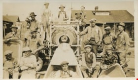
The Sidewalk Crew
https://search.heritageburnaby.ca/link/archivedescription35150
- Repository
- City of Burnaby Archives
- Date
- 1927
- Collection/Fonds
- Burnaby Historical Society fonds
- Description Level
- Item
- Physical Description
- 1 photograph : sepia ; 6.4 x 11.4 cm
- Scope and Content
- Photograph of George Pearson's crew, including future Reeve Charles "Charlie" MacSorley, laying cement sidewalk in Burnaby. A note on back of the photograph indicates that the back left two are Jack Elliot and Charles MacSorley.
- Repository
- City of Burnaby Archives
- Date
- 1927
- Collection/Fonds
- Burnaby Historical Society fonds
- Subseries
- Pioneer Tales subseries
- Physical Description
- 1 photograph : sepia ; 6.4 x 11.4 cm
- Description Level
- Item
- Record No.
- 204-007
- Access Restriction
- No restrictions
- Reproduction Restriction
- No known restrictions
- Accession Number
- BHS1988-03
- Scope and Content
- Photograph of George Pearson's crew, including future Reeve Charles "Charlie" MacSorley, laying cement sidewalk in Burnaby. A note on back of the photograph indicates that the back left two are Jack Elliot and Charles MacSorley.
- Subjects
- Officials - Mayors and Reeves
- Construction Tools and Equipment
- Occupations - Labourers
- Construction - Road Construction
- Media Type
- Photograph
- Photographer
- Pearson, George
- Notes
- Title based on caption on back of photograph
Images
![Big Bend flood, [1999] thumbnail](/media/hpo/_Data/_Archives_Images/_Unrestricted/535/535-3167-1.jpg?width=280)
Big Bend flood
https://search.heritageburnaby.ca/link/archivedescription98087
- Repository
- City of Burnaby Archives
- Date
- [1999]
- Collection/Fonds
- Burnaby NewsLeader photograph collection
- Description Level
- File
- Physical Description
- 3 photographs (tiff) : col.
- Scope and Content
- File contains photographs of unidentified people after a flood in the Big Bend area. Photographs depict a person standing in a farm field and adjusting a plant at Wing Wong's Nursery, and another person wearing a hard hat and posing with a construction vehicle.
- Repository
- City of Burnaby Archives
- Date
- [1999]
- Collection/Fonds
- Burnaby NewsLeader photograph collection
- Physical Description
- 3 photographs (tiff) : col.
- Description Level
- File
- Record No.
- 535-3167
- Access Restriction
- No restrictions
- Reproduction Restriction
- No restrictions
- Accession Number
- 2018-12
- Scope and Content
- File contains photographs of unidentified people after a flood in the Big Bend area. Photographs depict a person standing in a farm field and adjusting a plant at Wing Wong's Nursery, and another person wearing a hard hat and posing with a construction vehicle.
- Subjects
- Agriculture - Farms
- Buildings - Agricultural - Nurseries
- Construction Tools and Equipment
- Natural Phenomena - Floods
- Media Type
- Photograph
- Notes
- Title based on original file name
- Collected by editorial for use in a May 1999 issue of the Burnaby NewsLeader
- Geographic Access
- Marine Drive
- Street Address
- 4892 Marine Drive
- Historic Neighbourhood
- Fraser Arm (Historic Neighbourhood)
- Planning Study Area
- Big Bend Area
Images
![Big Bend flood, [1999] thumbnail](/media/hpo/_Data/_Archives_Images/_Unrestricted/535/535-3167-1.jpg)
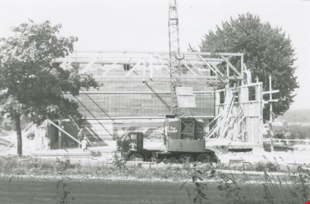
Douglas Road School gymnasium
https://search.heritageburnaby.ca/link/archivedescription38648
- Repository
- City of Burnaby Archives
- Date
- 1960
- Collection/Fonds
- Burnaby Historical Society fonds
- Description Level
- Item
- Physical Description
- 1 photograph : b&w ; 10 x 15 cm
- Scope and Content
- Photograph of two workmen (unidentified) standing next to a truckload of lumber outside the new Douglas Road School gymnasium.
- Repository
- City of Burnaby Archives
- Date
- 1960
- Collection/Fonds
- Burnaby Historical Society fonds
- Subseries
- Douglas Road School subseries
- Physical Description
- 1 photograph : b&w ; 10 x 15 cm
- Description Level
- Item
- Record No.
- 471-009
- Access Restriction
- No restrictions
- Reproduction Restriction
- Reproduce for fair dealing purposes only
- Accession Number
- BHS2005-3
- Scope and Content
- Photograph of two workmen (unidentified) standing next to a truckload of lumber outside the new Douglas Road School gymnasium.
- Names
- Douglas Road School
- Media Type
- Photograph
- Photographer
- Gordon, Ethel
- Notes
- Title based on contents of photograph.
- Geographic Access
- Douglas Road
- Canada Way
- Street Address
- 4861 Canada Way
- Historic Neighbourhood
- Burnaby Lake (Historic Neighbourhood)
- Planning Study Area
- Douglas-Gilpin Area
Images

Douglas Road School gymnasium construction
https://search.heritageburnaby.ca/link/archivedescription38646
- Repository
- City of Burnaby Archives
- Date
- 1960
- Collection/Fonds
- Burnaby Historical Society fonds
- Description Level
- Item
- Physical Description
- 1 photograph : b&w ; 10 x 15 cm
- Scope and Content
- Photograph of a crew of workmen working on the construction of the new Douglas Road School gymnasium. None of the men are identified.
- Repository
- City of Burnaby Archives
- Date
- 1960
- Collection/Fonds
- Burnaby Historical Society fonds
- Subseries
- Douglas Road School subseries
- Physical Description
- 1 photograph : b&w ; 10 x 15 cm
- Description Level
- Item
- Record No.
- 471-007
- Access Restriction
- No restrictions
- Reproduction Restriction
- Reproduce for fair dealing purposes only
- Accession Number
- BHS2005-3
- Scope and Content
- Photograph of a crew of workmen working on the construction of the new Douglas Road School gymnasium. None of the men are identified.
- Names
- Douglas Road School
- Media Type
- Photograph
- Photographer
- Gordon, Ethel
- Notes
- Title based on contents of photograph.
- Geographic Access
- Canada Way
- Street Address
- 4861 Canada Way
- Historic Neighbourhood
- Burnaby Lake (Historic Neighbourhood)
- Planning Study Area
- Douglas-Gilpin Area
Images
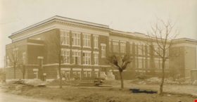
Gilmore School addition
https://search.heritageburnaby.ca/link/archivedescription38678
- Repository
- City of Burnaby Archives
- Date
- 1928
- Collection/Fonds
- Burnaby Historical Society fonds
- Description Level
- Item
- Physical Description
- 1 photograph : b&w ; 11 x 20.7 cm
- Scope and Content
- Photograph of the Gilmore School addition being built. Piles of lumber can be seen on the ground in front of the building and an unidentified man is standing by the lower window in the centre of the photograph.
- Repository
- City of Burnaby Archives
- Date
- 1928
- Collection/Fonds
- Burnaby Historical Society fonds
- Subseries
- North Burnaby Board of Trade subseries
- Physical Description
- 1 photograph : b&w ; 11 x 20.7 cm
- Description Level
- Item
- Record No.
- 476-021
- Access Restriction
- No restrictions
- Reproduction Restriction
- No known restrictions
- Accession Number
- BHS2005-8
- Scope and Content
- Photograph of the Gilmore School addition being built. Piles of lumber can be seen on the ground in front of the building and an unidentified man is standing by the lower window in the centre of the photograph.
- Names
- Gilmore Avenue School
- Media Type
- Photograph
- Notes
- Title based on content of photograph
- Geographic Access
- Gilmore Avenue
- Street Address
- 50 Gilmore Avenue
- Historic Neighbourhood
- Vancouver Heights (Historic Neighbourhood)
- Planning Study Area
- Burnaby Heights Area
Images

![Pile driving, [1919] thumbnail](/media/hpo/_Data/_BVM_Images/1974/197500330003am.jpg?width=280)
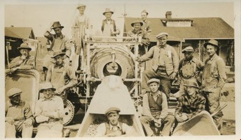
Pile driving
https://search.heritageburnaby.ca/link/museumdescription3524
- Repository
- Burnaby Village Museum
- Date
- [1919]
- Collection/Fonds
- Burnaby Village Museum Photograph collection
- Description Level
- Item
- Physical Description
- 1 photograph : sepia ; 13 x 8 cm
- Scope and Content
- Photograph of a pile being lifted into a steam-powered pile driver tower near an industrial building at an unidentified location. Two labourers are visible working with the donkey engine and pile driver.
- Repository
- Burnaby Village Museum
- Collection/Fonds
- Burnaby Village Museum Photograph collection
- Description Level
- Item
- Physical Description
- 1 photograph : sepia ; 13 x 8 cm
- Scope and Content
- Photograph of a pile being lifted into a steam-powered pile driver tower near an industrial building at an unidentified location. Two labourers are visible working with the donkey engine and pile driver.
- Accession Code
- HV975.33.3am
- Access Restriction
- No restrictions
- Date
- [1919]
- Media Type
- Photograph
- Scan Resolution
- 600
- Scan Date
- 2/2/2010
- Scale
- 100
- Notes
- Title based on contents of photograph
- Image from personal photograph album of Tom "Tommy" Irvine (HV975.33.3)
Images
![Pile driving, [1919] thumbnail](/media/hpo/_Data/_BVM_Images/1974/197500330003am.jpg)
![Real Estate - Surveyor's office building, [1977] thumbnail](/media/hpo/_Data/_BVM_Images/2020/2020_0005_1513_001.jpg?width=280)
Real Estate - Surveyor's office building
https://search.heritageburnaby.ca/link/museumdescription14685
- Repository
- Burnaby Village Museum
- Date
- [1977]
- Collection/Fonds
- Century Park Museum Association fonds
- Description Level
- Item
- Physical Description
- 1 photograph : col. slide ; 35 mm
- Scope and Content
- Photograph of the Real Estate Office and Surveyor's building on top of a flatbed truck trailer with jacks and wood cribbing piles at the end. The Royal Bank building is visible to the left.
- Repository
- Burnaby Village Museum
- Collection/Fonds
- Century Park Museum Association fonds
- Description Level
- Item
- Physical Description
- 1 photograph : col. slide ; 35 mm
- Scope and Content
- Photograph of the Real Estate Office and Surveyor's building on top of a flatbed truck trailer with jacks and wood cribbing piles at the end. The Royal Bank building is visible to the left.
- History
- The building was originally located at 3043 (pre-1958) / 6108 Patterson Avenue, Lot 22, Block 33, District Lot 151, Plan 2002. It was built ca. 1929, possibly by Mr. Cuthbert Pratt. Over the years it was used as a confectionary store, grocery store, home, and small boarding house. By 1977, it was operating as the Magee Grocery Store. The building was moved to BVM in May 1977 and then adapted to look like the original Dow, Fraser & Co. Ltd. real estate building.
- Names
- Burnaby Village Museum
- Accession Code
- BV020.5.1513
- Access Restriction
- No restrictions
- Reproduction Restriction
- No known restrictions
- Date
- [1977]
- Media Type
- Photograph
- Scan Resolution
- 2400
- Scan Date
- 17-Nov-2020
- Scale
- 100
- Notes
- Title based on contents of photograph
Images
![Real Estate - Surveyor's office building, [1977] thumbnail](/media/hpo/_Data/_BVM_Images/2020/2020_0005_1513_001.jpg)
![Real Estate - Surveyor's office building, [1977] thumbnail](/media/hpo/_Data/_BVM_Images/2020/2020_0005_1514_001.jpg?width=280)
Real Estate - Surveyor's office building
https://search.heritageburnaby.ca/link/museumdescription14686
- Repository
- Burnaby Village Museum
- Date
- [1977]
- Collection/Fonds
- Century Park Museum Association fonds
- Description Level
- Item
- Physical Description
- 1 photograph : col. slide ; 35 mm
- Scope and Content
- Photograph of the Real Estate Office and Surveyor's building on top of a flatbed truck trailer. A man is visible crouching underneath next to a cribbing pile.
- Repository
- Burnaby Village Museum
- Collection/Fonds
- Century Park Museum Association fonds
- Description Level
- Item
- Physical Description
- 1 photograph : col. slide ; 35 mm
- Scope and Content
- Photograph of the Real Estate Office and Surveyor's building on top of a flatbed truck trailer. A man is visible crouching underneath next to a cribbing pile.
- History
- The building was originally located at 3043 (pre-1958) / 6108 Patterson Avenue, Lot 22, Block 33, District Lot 151, Plan 2002. It was built ca. 1929, possibly by Mr. Cuthbert Pratt. Over the years it was used as a confectionary store, grocery store, home, and small boarding house. By 1977, it was operating as the Magee Grocery Store. The building was moved to BVM in May 1977 and then adapted to look like the original Dow, Fraser & Co. Ltd. real estate building.
- Names
- Burnaby Village Museum
- Accession Code
- BV020.5.1514
- Access Restriction
- No restrictions
- Reproduction Restriction
- No known restrictions
- Date
- [1977]
- Media Type
- Photograph
- Scan Resolution
- 2400
- Scan Date
- 17-Nov-2020
- Scale
- 100
- Notes
- Title based on contents of photograph
Images
![Real Estate - Surveyor's office building, [1977] thumbnail](/media/hpo/_Data/_BVM_Images/2020/2020_0005_1514_001.jpg)
![Scaffolding for submarine construction, [1917] (date of original), copied 2004 thumbnail](/media/hpo/_Data/_Archives_Images/_Unrestricted/371/466-015.jpg?width=280)
Scaffolding for submarine construction
https://search.heritageburnaby.ca/link/archivedescription38616
- Repository
- City of Burnaby Archives
- Date
- [1917] (date of original), copied 2004
- Collection/Fonds
- Burnaby Historical Society fonds
- Description Level
- Item
- Physical Description
- 1 photograph : b&w ; 20 x 28 cm print
- Scope and Content
- Photograph of scaffolding set up for the manufacture of submarines at the submarine works yard at Barnet. Numerous labourers and two industrial buildings can be seen in the background. During World War One, the Royal Russian Navy contracted with a Seattle-based company to build submarines for Russi…
- Repository
- City of Burnaby Archives
- Date
- [1917] (date of original), copied 2004
- Collection/Fonds
- Burnaby Historical Society fonds
- Subseries
- Jim Wolf subseries
- Physical Description
- 1 photograph : b&w ; 20 x 28 cm print
- Description Level
- Item
- Record No.
- 466-015
- Access Restriction
- No restrictions
- Reproduction Restriction
- No known restrictions
- Accession Number
- BHS2004-9
- Scope and Content
- Photograph of scaffolding set up for the manufacture of submarines at the submarine works yard at Barnet. Numerous labourers and two industrial buildings can be seen in the background. During World War One, the Royal Russian Navy contracted with a Seattle-based company to build submarines for Russia, but American neutrality in the war prevented the subs from being built in the United States. Instead, the company operated a facility at Barnet to complete the contract.
- Subjects
- Transportation - Submarines
- Wars - World War, 1914-1918
- Construction Tools and Equipment
- Buildings - Industrial
- Occupations - Labourers
- Names
- Royal Russian Navy
- Media Type
- Photograph
- Notes
- Title based on contents of photograph.
- Geographic Access
- Barnet Village
- Barnet Road
- Street Address
- 8774 Barnet Road
- Historic Neighbourhood
- Barnet (Historic Neighbourhood)
- Planning Study Area
- Burnaby Mountain Area
Images
![Scaffolding for submarine construction, [1917] (date of original), copied 2004 thumbnail](/media/hpo/_Data/_Archives_Images/_Unrestricted/371/466-015.jpg)
![Submarine works yard at Barnet, [1917] (date of original), copied 2004 thumbnail](/media/hpo/_Data/_Archives_Images/_Unrestricted/371/466-005.jpg?width=280)
Submarine works yard at Barnet
https://search.heritageburnaby.ca/link/archivedescription38606
- Repository
- City of Burnaby Archives
- Date
- [1917] (date of original), copied 2004
- Collection/Fonds
- Burnaby Historical Society fonds
- Description Level
- Item
- Physical Description
- 1 photograph : b&w ; 20 x 28 cm print
- Scope and Content
- Photograph of the submarine works yard at Barnet in Burnaby. During World War One, the Royal Russian Navy contracted with a Seattle-based company to build submarines for Russia, but American neutrality in the war prevented the subs from being built in the United States. Instead, the company operat…
- Repository
- City of Burnaby Archives
- Date
- [1917] (date of original), copied 2004
- Collection/Fonds
- Burnaby Historical Society fonds
- Subseries
- Jim Wolf subseries
- Physical Description
- 1 photograph : b&w ; 20 x 28 cm print
- Description Level
- Item
- Record No.
- 466-005
- Access Restriction
- No restrictions
- Reproduction Restriction
- No known restrictions
- Accession Number
- BHS2004-9
- Scope and Content
- Photograph of the submarine works yard at Barnet in Burnaby. During World War One, the Royal Russian Navy contracted with a Seattle-based company to build submarines for Russia, but American neutrality in the war prevented the subs from being built in the United States. Instead, the company operated a facility at Barnet to complete the contract.
- Subjects
- Buildings - Industrial
- Transportation - Submarines
- Wars - World War, 1914-1918
- Occupations - Labourers
- Construction Tools and Equipment
- Names
- Royal Russian Navy
- Media Type
- Photograph
- Notes
- Title based on contents of photograph
- Geographic Access
- Barnet Road
- Barnet Village
- Street Address
- 8774 Barnet Road
- Historic Neighbourhood
- Barnet (Historic Neighbourhood)
- Planning Study Area
- Burnaby Mountain Area
Images
![Submarine works yard at Barnet, [1917] (date of original), copied 2004 thumbnail](/media/hpo/_Data/_Archives_Images/_Unrestricted/371/466-005.jpg)
![Submarine works yard at Barnet, [1917] (date of original), copied 2004 thumbnail](/media/hpo/_Data/_Archives_Images/_Unrestricted/371/466-010.jpg?width=280)
Submarine works yard at Barnet
https://search.heritageburnaby.ca/link/archivedescription38611
- Repository
- City of Burnaby Archives
- Date
- [1917] (date of original), copied 2004
- Collection/Fonds
- Burnaby Historical Society fonds
- Description Level
- Item
- Physical Description
- 1 photograph : b&w ; 20 x 28 cm print
- Scope and Content
- Photograph of the submarine works yard at Barnet. Visible in the photograph is the extensive system of scaffolding used during construction and to the right a building can be seen. During World War One, the Royal Russian Navy contracted with a Seattle-based company to build submarines for Russia, …
- Repository
- City of Burnaby Archives
- Date
- [1917] (date of original), copied 2004
- Collection/Fonds
- Burnaby Historical Society fonds
- Subseries
- Jim Wolf subseries
- Physical Description
- 1 photograph : b&w ; 20 x 28 cm print
- Description Level
- Item
- Record No.
- 466-010
- Access Restriction
- No restrictions
- Reproduction Restriction
- No known restrictions
- Accession Number
- BHS2004-9
- Scope and Content
- Photograph of the submarine works yard at Barnet. Visible in the photograph is the extensive system of scaffolding used during construction and to the right a building can be seen. During World War One, the Royal Russian Navy contracted with a Seattle-based company to build submarines for Russia, but American neutrality in the war prevented the subs from being built in the United States. Instead, the company operated a facility at Barnet to complete the contract.
- Subjects
- Transportation - Submarines
- Wars - World War, 1914-1918
- Construction Tools and Equipment
- Buildings - Industrial
- Names
- Royal Russian Navy
- Media Type
- Photograph
- Notes
- Title based on contents of photograph.
- Geographic Access
- Barnet Village
- Barnet Road
- Street Address
- 8774 Barnet Road
- Historic Neighbourhood
- Barnet (Historic Neighbourhood)
- Planning Study Area
- Burnaby Mountain Area
Images
![Submarine works yard at Barnet, [1917] (date of original), copied 2004 thumbnail](/media/hpo/_Data/_Archives_Images/_Unrestricted/371/466-010.jpg)
![202 Delta Avenue under construction, [1948] (date of original), copied 1991 thumbnail](/media/hpo/_Data/_Archives_Images/_Unrestricted/370/370-226.jpg?width=280)
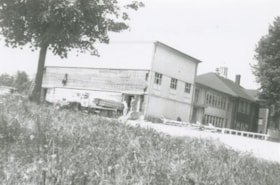
202 Delta Avenue under construction
https://search.heritageburnaby.ca/link/archivedescription37638
- Repository
- City of Burnaby Archives
- Date
- [1948] (date of original), copied 1991
- Collection/Fonds
- Burnaby Historical Society fonds
- Description Level
- Item
- Physical Description
- 1 photograph : b&w ; 3.2 x 5.3 cm print on contact sheet 20.2 x 25.3 cm
- Scope and Content
- Photograph of the house at 202 Delta Avenue under construction.
- Repository
- City of Burnaby Archives
- Date
- [1948] (date of original), copied 1991
- Collection/Fonds
- Burnaby Historical Society fonds
- Subseries
- Burnaby Image Bank subseries
- Physical Description
- 1 photograph : b&w ; 3.2 x 5.3 cm print on contact sheet 20.2 x 25.3 cm
- Description Level
- Item
- Record No.
- 370-226
- Access Restriction
- No restrictions
- Reproduction Restriction
- No known restrictions
- Accession Number
- BHS1999-03
- Scope and Content
- Photograph of the house at 202 Delta Avenue under construction.
- Media Type
- Photograph
- Notes
- Title based on contents of photograph
- 1 b&w copy negative accompanying
- Geographic Access
- Delta Avenue
- Street Address
- 202 Delta Avenue
- Historic Neighbourhood
- Capitol Hill (Historic Neighbourhood)
- Planning Study Area
- Capitol Hill Area
Images
![202 Delta Avenue under construction, [1948] (date of original), copied 1991 thumbnail](/media/hpo/_Data/_Archives_Images/_Unrestricted/370/370-226.jpg)
![202 Delta Avenue under construction, [1949] (date of original), copied 1991 thumbnail](/media/hpo/_Data/_Archives_Images/_Unrestricted/370/370-227.jpg?width=280)
202 Delta Avenue under construction
https://search.heritageburnaby.ca/link/archivedescription37639
- Repository
- City of Burnaby Archives
- Date
- [1949] (date of original), copied 1991
- Collection/Fonds
- Burnaby Historical Society fonds
- Description Level
- Item
- Physical Description
- 1 photograph : b&w ; 3.2 x 5.3 cm print on contact sheet 20.2 x 25.3 cm
- Scope and Content
- Photograph of the house at 202 Delta Avenue under construction.
- Repository
- City of Burnaby Archives
- Date
- [1949] (date of original), copied 1991
- Collection/Fonds
- Burnaby Historical Society fonds
- Subseries
- Burnaby Image Bank subseries
- Physical Description
- 1 photograph : b&w ; 3.2 x 5.3 cm print on contact sheet 20.2 x 25.3 cm
- Description Level
- Item
- Record No.
- 370-227
- Access Restriction
- No restrictions
- Reproduction Restriction
- No restrictions
- Accession Number
- BHS1999-03
- Scope and Content
- Photograph of the house at 202 Delta Avenue under construction.
- Media Type
- Photograph
- Notes
- Title based on contents of photograph
- 1 b&w copy negative accompanying
- Geographic Access
- Delta Avenue
- Street Address
- 202 Delta Avenue
- Historic Neighbourhood
- Capitol Hill (Historic Neighbourhood)
- Planning Study Area
- Capitol Hill Area
Images
![202 Delta Avenue under construction, [1949] (date of original), copied 1991 thumbnail](/media/hpo/_Data/_Archives_Images/_Unrestricted/370/370-227.jpg)

1982 - Moving the Roberts House
https://search.heritageburnaby.ca/link/archivedescription91888
- Repository
- City of Burnaby Archives
- Date
- September 1982
- Collection/Fonds
- Small family fonds
- Description Level
- Item
- Physical Description
- 1 photograph : col. ; 9 cm x 13 cm
- Scope and Content
- Photograph of the Roberts' house in its new position at 5496 Dominion Street. Perimeter "pony" walls and other interior supporting walls were built to support the house. All of the plumbing and electrical wiring were replaced.
- Repository
- City of Burnaby Archives
- Date
- September 1982
- Collection/Fonds
- Small family fonds
- Physical Description
- 1 photograph : col. ; 9 cm x 13 cm
- Description Level
- Item
- Record No.
- 620-069
- Access Restriction
- No restrictions
- Reproduction Restriction
- No reproduction permitted
- Accession Number
- 2017-01
- Scope and Content
- Photograph of the Roberts' house in its new position at 5496 Dominion Street. Perimeter "pony" walls and other interior supporting walls were built to support the house. All of the plumbing and electrical wiring were replaced.
- Media Type
- Photograph
- Notes
- Transcribed title
- Title transcribed from donor's notes
- Note in blue ink on verso of photograph reads: "B5 P11"
- Note in pencil on verso of photograph reads: "10"
- Note in black ink on verso of photograph reads: "Sept. 82"
- Street Address
- 5496 Dominion Street
- Historic Neighbourhood
- Burnaby Lake (Historic Neighbourhood)
- Planning Study Area
- Ardingley-Sprott Area
Images


1982 - Moving the Roberts House
https://search.heritageburnaby.ca/link/archivedescription91889
- Repository
- City of Burnaby Archives
- Date
- September 1982
- Collection/Fonds
- Small family fonds
- Description Level
- Item
- Physical Description
- 1 photograph : col. ; 9 cm x 13 cm
- Scope and Content
- Photograph of the Roberts' house in its new position at 5496 Dominion Street with an additional "cold storage" room added beneath the front porch and windows installed.
- Repository
- City of Burnaby Archives
- Date
- September 1982
- Collection/Fonds
- Small family fonds
- Physical Description
- 1 photograph : col. ; 9 cm x 13 cm
- Description Level
- Item
- Record No.
- 620-070
- Access Restriction
- No restrictions
- Reproduction Restriction
- No reproduction permitted
- Accession Number
- 2017-01
- Scope and Content
- Photograph of the Roberts' house in its new position at 5496 Dominion Street with an additional "cold storage" room added beneath the front porch and windows installed.
- Media Type
- Photograph
- Notes
- Transcribed title
- Title transcribed from donor's notes
- Note in blue ink on verso of photograph reads: "B10 P12"
- Note in pencil on verso of photograph reads: "11"
- Note in black ink on verso of photograph reads: "Sept. 82"
- Street Address
- 5496 Dominion Street
- Historic Neighbourhood
- Burnaby Lake (Historic Neighbourhood)
- Planning Study Area
- Ardingley-Sprott Area
Images


1982 - Moving the Roberts House
https://search.heritageburnaby.ca/link/archivedescription91890
- Repository
- City of Burnaby Archives
- Date
- November 1982
- Collection/Fonds
- Small family fonds
- Description Level
- Item
- Physical Description
- 1 photograph : col. ; 9 cm x 13 cm
- Scope and Content
- Photograph of the Roberts' house in its new position at 5496 Dominion Street. Cedar siding was added to finish the exterior, the original white pillars were re-installed on the front porch, the house was stained, and basic landscaping was completed.
- Repository
- City of Burnaby Archives
- Date
- November 1982
- Collection/Fonds
- Small family fonds
- Physical Description
- 1 photograph : col. ; 9 cm x 13 cm
- Description Level
- Item
- Record No.
- 620-071
- Access Restriction
- No restrictions
- Reproduction Restriction
- No reproduction permitted
- Accession Number
- 2017-01
- Scope and Content
- Photograph of the Roberts' house in its new position at 5496 Dominion Street. Cedar siding was added to finish the exterior, the original white pillars were re-installed on the front porch, the house was stained, and basic landscaping was completed.
- Media Type
- Photograph
- Notes
- Transcribed title
- Title transcribed from donor's notes
- Note in blue ink on verso of photograph reads: "B19 P13"
- Note in pencil on verso of photograph reads: "12"
- Note in black ink on verso of photograph reads: "Front Steps Now! and A New Staining Job. / Nov. 1982"
- Street Address
- 5496 Dominion Street
- Historic Neighbourhood
- Burnaby Lake (Historic Neighbourhood)
- Planning Study Area
- Ardingley-Sprott Area
Images


1982 - Moving the Roberts House
https://search.heritageburnaby.ca/link/archivedescription91893
- Repository
- City of Burnaby Archives
- Date
- 1982 (date of original), copied 2017
- Collection/Fonds
- Small family fonds
- Description Level
- Item
- Physical Description
- 1 photograph : col. copy print ; 10 cm x 15 cm
- Scope and Content
- Photograph of new houses being constructed on the 33 foot lots between 5496 Dominion Street and Douglas Road. Framing is complete and the houses' roofs and windows are installed.
- Repository
- City of Burnaby Archives
- Date
- 1982 (date of original), copied 2017
- Collection/Fonds
- Small family fonds
- Physical Description
- 1 photograph : col. copy print ; 10 cm x 15 cm
- Description Level
- Item
- Record No.
- 620-074
- Access Restriction
- No restrictions
- Reproduction Restriction
- No reproduction permitted
- Accession Number
- 2017-01
- Scope and Content
- Photograph of new houses being constructed on the 33 foot lots between 5496 Dominion Street and Douglas Road. Framing is complete and the houses' roofs and windows are installed.
- Media Type
- Photograph
- Notes
- Transcribed title
- Title transcribed from donor's notes
- Note in blue ink on verso of photograph reads: "P.16"
- Geographic Access
- Dominion Street
- Street Address
- 5496 Dominion Street
- Historic Neighbourhood
- Burnaby Lake (Historic Neighbourhood)
- Planning Study Area
- Ardingley-Sprott Area
Images


2924 Silver Avenue
https://search.heritageburnaby.ca/link/archivedescription37753
- Repository
- City of Burnaby Archives
- Date
- June 1954 (date of original), copied 1991
- Collection/Fonds
- Burnaby Historical Society fonds
- Description Level
- Item
- Physical Description
- 1 photograph : b&w ; 2.6 x 3.9 cm print on contact sheet 20.5 x 26.4 cm
- Scope and Content
- Photograph of the construction of an addition to 2924 Silver Avenue (later renumbered 6113 Silver Avenue). Three people are on the roof of the house, and two others are on a ladder.
- Repository
- City of Burnaby Archives
- Date
- June 1954 (date of original), copied 1991
- Collection/Fonds
- Burnaby Historical Society fonds
- Subseries
- Burnaby Image Bank subseries
- Physical Description
- 1 photograph : b&w ; 2.6 x 3.9 cm print on contact sheet 20.5 x 26.4 cm
- Description Level
- Item
- Record No.
- 370-341
- Access Restriction
- No restrictions
- Reproduction Restriction
- No restrictions
- Accession Number
- BHS1999-03
- Scope and Content
- Photograph of the construction of an addition to 2924 Silver Avenue (later renumbered 6113 Silver Avenue). Three people are on the roof of the house, and two others are on a ladder.
- Media Type
- Photograph
- Notes
- Title based on contents of photograph
- 1 b&w copy negative accompanying
- Negative has a pink cast
- Geographic Access
- Silver Avenue
- Street Address
- 6113 Silver Avenue
- Historic Neighbourhood
- Central Park (Historic Neighbourhood)
- Planning Study Area
- Maywood Area
Images

![5165 Sperling Avenue construction, [1941 or 1942] (date of original), copied 1991 thumbnail](/media/hpo/_Data/_Archives_Images/_Unrestricted/370/370-550.jpg?width=280)
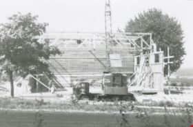
5165 Sperling Avenue construction
https://search.heritageburnaby.ca/link/archivedescription37963
- Repository
- City of Burnaby Archives
- Date
- [1941 or 1942] (date of original), copied 1991
- Collection/Fonds
- Burnaby Historical Society fonds
- Description Level
- Item
- Physical Description
- 1 photograph : b&w ; 2.6 x 3.7 cm print on contact sheet 20.7 x 26.2 cm
- Scope and Content
- Photograph of the house of the Montague Moore family under construction at 5165 Sperling Avenue.
- Repository
- City of Burnaby Archives
- Date
- [1941 or 1942] (date of original), copied 1991
- Collection/Fonds
- Burnaby Historical Society fonds
- Subseries
- Burnaby Image Bank subseries
- Physical Description
- 1 photograph : b&w ; 2.6 x 3.7 cm print on contact sheet 20.7 x 26.2 cm
- Description Level
- Item
- Record No.
- 370-550
- Access Restriction
- No restrictions
- Reproduction Restriction
- No known restrictions
- Accession Number
- BHS1999-03
- Scope and Content
- Photograph of the house of the Montague Moore family under construction at 5165 Sperling Avenue.
- Media Type
- Photograph
- Notes
- Title based on contents of photograph
- 1 b&w copy negative accompanying
- Geographic Access
- Sperling Avenue
- Street Address
- 5165 Sperling Avenue
- Historic Neighbourhood
- Burnaby Lake (Historic Neighbourhood)
- Planning Study Area
- Morley-Buckingham Area
Images
![5165 Sperling Avenue construction, [1941 or 1942] (date of original), copied 1991 thumbnail](/media/hpo/_Data/_Archives_Images/_Unrestricted/370/370-550.jpg)
![5165 Sperling Avenue construction, [1941 or 1942] (date of original), copied 1991 thumbnail](/media/hpo/_Data/_Archives_Images/_Unrestricted/370/370-551.jpg?width=280)
5165 Sperling Avenue construction
https://search.heritageburnaby.ca/link/archivedescription37964
- Repository
- City of Burnaby Archives
- Date
- [1941 or 1942] (date of original), copied 1991
- Collection/Fonds
- Burnaby Historical Society fonds
- Description Level
- Item
- Physical Description
- 1 photograph : b&w ; 2.6 x 3.7 cm print on contact sheet 20.7 x 26.2 cm
- Scope and Content
- Photograph of the house of the Montague Moore family under construction at 5165 Sperling Avenue. Other houses on the street can be seen to the right, and the road can be seen in the foreground.
- Repository
- City of Burnaby Archives
- Date
- [1941 or 1942] (date of original), copied 1991
- Collection/Fonds
- Burnaby Historical Society fonds
- Subseries
- Burnaby Image Bank subseries
- Physical Description
- 1 photograph : b&w ; 2.6 x 3.7 cm print on contact sheet 20.7 x 26.2 cm
- Description Level
- Item
- Record No.
- 370-551
- Access Restriction
- No restrictions
- Reproduction Restriction
- No known restrictions
- Accession Number
- BHS1999-03
- Scope and Content
- Photograph of the house of the Montague Moore family under construction at 5165 Sperling Avenue. Other houses on the street can be seen to the right, and the road can be seen in the foreground.
- Media Type
- Photograph
- Notes
- Title based on contents of photograph
- 1 b&w copy negative accompanying
- Geographic Access
- Sperling Avenue
- Street Address
- 5165 Sperling Avenue
- Historic Neighbourhood
- Burnaby Lake (Historic Neighbourhood)
- Planning Study Area
- Morley-Buckingham Area
Images
![5165 Sperling Avenue construction, [1941 or 1942] (date of original), copied 1991 thumbnail](/media/hpo/_Data/_Archives_Images/_Unrestricted/370/370-551.jpg)