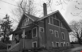
More like 'Looking east from north side of 5118 Douglas Road - The Roberts House'
Narrow Results By
Decade
- 2020s 95
- 2010s 40
- 2000s 384
- 1990s 281
- 1980s 366
- 1970s 923
- 1960s 273
- 1950s 457
- 1940s 417
- 1930s 344
- 1920s 366
- 1910s 440
- 1900s 169
- 1890s 23
- 1880s 49
- 1870s 3
- 1860s 1
- 1850s 1
- 1840s 1
- 1830s 1
- 1820s 1
- 1810s 1
- 1800s 1
- 1790s 1
- 1780s 1
- 1770s 1
- 1760s 1
- 1750s 1
- 1740s 1
- 1730s 1
- 1720s 1
- 1710s 1
- 1700s 1
- 1690s 1
- 1680s 1
- 1670s 1
- 1660s 1
- 1650s 1
- 1640s 1
- 1630s 1
- 1620s 1
- 1610s 1
- 1600s 1
Exterior of Cunningham house
https://search.heritageburnaby.ca/link/museumdescription17956
- Repository
- Burnaby Village Museum
- Date
- Jan. 1991
- Collection/Fonds
- Burnaby Village Museum Photograph collection
- Description Level
- Item
- Physical Description
- 1 photograph : col. negative ; 35 mm
- Scope and Content
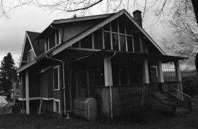
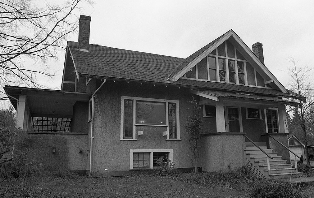
- Photograph of the Cunningham house located at 3555 Douglas Road, Burnaby. Side view of house with porch and trellises. The house was built in 1923 on the property owned by Fred and Edna Cunningham. The Cunningham house was designated as a heritage building in 1996.
- Repository
- Burnaby Village Museum
- Collection/Fonds
- Burnaby Village Museum Photograph collection
- Description Level
- Item
- Physical Description
- 1 photograph : col. negative ; 35 mm
- Scope and Content
- Photograph of the Cunningham house located at 3555 Douglas Road, Burnaby. Side view of house with porch and trellises. The house was built in 1923 on the property owned by Fred and Edna Cunningham. The Cunningham house was designated as a heritage building in 1996.
- Geographic Access
- Douglas Road
- Street Address
- 3555 Douglas Road
- Accession Code
- BV022.3.20
- Access Restriction
- No restrictions
- Reproduction Restriction
- No known restrictions
- Date
- Jan. 1991
- Media Type
- Photograph
- Historic Neighbourhood
- Burnaby Lake (Historic Neighbourhood)
- Planning Study Area
- Douglas-Gilpin Area
- Scan Resolution
- 2400
- Scan Date
- 2021-08-24
- Photographer
- Stevens, Colin
- Notes
- Title based on contents of photograph
- Photograph from Roll P92-4, negative #20
- 1 b&w. print accompanying
- Note in black ink on verso of accompanying photograph print reads: "P92-4-20"
Images
Exterior of Cunningham house
https://search.heritageburnaby.ca/link/museumdescription17959
- Repository
- Burnaby Village Museum
- Date
- Jan. 1991
- Collection/Fonds
- Burnaby Village Museum Photograph collection
- Description Level
- Item
- Physical Description
- 1 photograph : col. negative ; 35 mm
- Scope and Content
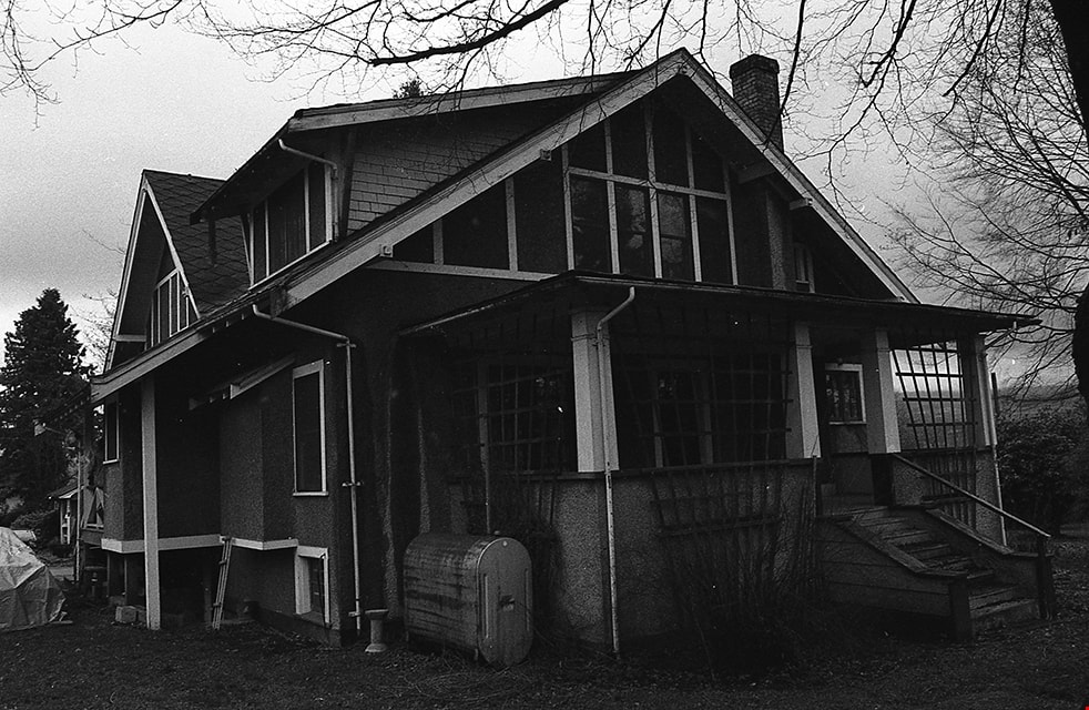
- Photograph of exterior of the Cunningham house located at 3555 Douglas Road, Burnaby. View of the front of the house with side porch to the left. The house was built in 1923 on the property owned by Fred and Edna Cunningham. The Cunningham house was designated as a heritage building in 1996.
- Repository
- Burnaby Village Museum
- Collection/Fonds
- Burnaby Village Museum Photograph collection
- Description Level
- Item
- Physical Description
- 1 photograph : col. negative ; 35 mm
- Scope and Content
- Photograph of exterior of the Cunningham house located at 3555 Douglas Road, Burnaby. View of the front of the house with side porch to the left. The house was built in 1923 on the property owned by Fred and Edna Cunningham. The Cunningham house was designated as a heritage building in 1996.
- Geographic Access
- Douglas Road
- Street Address
- 3555 Douglas Road
- Accession Code
- BV022.3.23
- Access Restriction
- No restrictions
- Reproduction Restriction
- No known restrictions
- Date
- Jan. 1991
- Media Type
- Photograph
- Historic Neighbourhood
- Burnaby Lake (Historic Neighbourhood)
- Planning Study Area
- Douglas-Gilpin Area
- Scan Resolution
- 2400
- Scan Date
- 2021-08-24
- Photographer
- Stevens, Colin
- Notes
- Title based on contents of photograph
- Photograph from Roll P92-4, negative #23
- 1 b&w. print accompanying
- Note in black ink on verso of accompanying photograph print reads: "P92-4-23"
Images
Exterior of Cunningham house
https://search.heritageburnaby.ca/link/museumdescription17961
- Repository
- Burnaby Village Museum
- Date
- Jan. 1991
- Collection/Fonds
- Burnaby Village Museum Photograph collection
- Description Level
- Item
- Physical Description
- 1 photograph : col. negative ; 35 mm
- Scope and Content
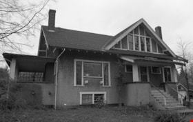
- Photograph of exterior of the Cunningham house located at 3555 Douglas Road, Burnaby. View of the front and side of the house with driveway. The house was built in 1923 on the property owned by Fred and Edna Cunningham. The Cunningham house was designated as a heritage building in 1996.
- Repository
- Burnaby Village Museum
- Collection/Fonds
- Burnaby Village Museum Photograph collection
- Description Level
- Item
- Physical Description
- 1 photograph : col. negative ; 35 mm
- Scope and Content
- Photograph of exterior of the Cunningham house located at 3555 Douglas Road, Burnaby. View of the front and side of the house with driveway. The house was built in 1923 on the property owned by Fred and Edna Cunningham. The Cunningham house was designated as a heritage building in 1996.
- Geographic Access
- Douglas Road
- Street Address
- 3555 Douglas Road
- Accession Code
- BV022.3.24
- Access Restriction
- No restrictions
- Reproduction Restriction
- No known restrictions
- Date
- Jan. 1991
- Media Type
- Photograph
- Historic Neighbourhood
- Burnaby Lake (Historic Neighbourhood)
- Planning Study Area
- Douglas-Gilpin Area
- Scan Resolution
- 2400
- Scan Date
- 2021-08-24
- Photographer
- Stevens, Colin
- Notes
- Title based on contents of photograph
- Photograph from Roll P92-4, negative #24
- 1 b&w. print accompanying
- Note in black ink on verso of accompanying photograph print reads: "P92-4-24"
Images


Exterior of Love farmhouse
https://search.heritageburnaby.ca/link/museumdescription1129
- Repository
- Burnaby Village Museum
- Date
- 1971 (date of original), copied 1990
- Collection/Fonds
- Love family fonds
- Description Level
- Item
- Physical Description
- 1 photograph : col. ; 10 x 15 cm print
- Scope and Content
- Photograph of the northern exterior of the Love farmhouse while Elsie (nee Love) Hughes, her husband John and son Brent lived in the house. The one storey section housed the kitchen which was added in 1903 to the original house which was built in 1893. The house is located at 7651 Cumberland Stree…
- Repository
- Burnaby Village Museum
- Collection/Fonds
- Love family fonds
- Description Level
- Item
- Physical Description
- 1 photograph : col. ; 10 x 15 cm print
- Material Details
- Copy print was made from re-photographing an original colour slide
- Scope and Content
- Photograph of the northern exterior of the Love farmhouse while Elsie (nee Love) Hughes, her husband John and son Brent lived in the house. The one storey section housed the kitchen which was added in 1903 to the original house which was built in 1893. The house is located at 7651 Cumberland Street (Address pre 1960: 1390 Cumberland Road) and was moved from its original site to the Burnaby Village Museum in 1988 and designated a Municipal Heritage Landmark in 1992.
- Geographic Access
- Cumberland Street
- Street Address
- 7651 Cumberland Street
- Accession Code
- BV992.15.10
- Access Restriction
- Restricted access
- Reproduction Restriction
- May be restricted by third party rights
- Date
- 1971 (date of original), copied 1990
- Media Type
- Photograph
- Historic Neighbourhood
- East Burnaby (Historic Neighbourhood)
- Planning Study Area
- Cariboo-Armstrong Area
- Scan Resolution
- 600
- Scan Date
- 01-Jun-09
- Scale
- 100
- Photographer
- Parker, Albert "Bert"
- Notes
- Title based on contents of photograph
Images


Exterior of Love farmhouse
https://search.heritageburnaby.ca/link/museumdescription1130
- Repository
- Burnaby Village Museum
- Date
- 1971 (date of original), copied 1990
- Collection/Fonds
- Love family fonds
- Description Level
- Item
- Physical Description
- 1 photograph : col. ; 10 x 15 cm print
- Scope and Content
- Photograph of the exterior of the west side of the Love farnhouse while Elsie (nee Love) Hughes, her husband John and son Brent lived in the house.The one storey section housed the kitchen which was attached to the main house in 1903. The house was located at 7651 Cumberland Street (Address pre 196…
- Repository
- Burnaby Village Museum
- Collection/Fonds
- Love family fonds
- Description Level
- Item
- Physical Description
- 1 photograph : col. ; 10 x 15 cm print
- Material Details
- Copy print was made from re-photographing an original colour slide
- Scope and Content
- Photograph of the exterior of the west side of the Love farnhouse while Elsie (nee Love) Hughes, her husband John and son Brent lived in the house.The one storey section housed the kitchen which was attached to the main house in 1903. The house was located at 7651 Cumberland Street (Address pre 1960: 1390 Cumberland Road) and was moved from its original site to the Burnaby Village Museum in 1988 and designated a Municipal Heritage Landmark in 1992.
- Geographic Access
- Cumberland Street
- Street Address
- 7651 Cumberland Street
- Accession Code
- BV992.15.11
- Access Restriction
- Restricted access
- Reproduction Restriction
- May be restricted by third party rights
- Date
- 1971 (date of original), copied 1990
- Media Type
- Photograph
- Historic Neighbourhood
- East Burnaby (Historic Neighbourhood)
- Planning Study Area
- Cariboo-Armstrong Area
- Scan Resolution
- 600
- Scan Date
- 01-Jun-09
- Scale
- 100
- Photographer
- Parker, Albert "Bert"
- Notes
- Title based on contents of photograph
Images


Exterior of Love farmhouse
https://search.heritageburnaby.ca/link/museumdescription1131
- Repository
- Burnaby Village Museum
- Date
- 1971 (date of original), copied 1990
- Collection/Fonds
- Love family fonds
- Description Level
- Item
- Physical Description
- 1 photograph : col. ; 10 x 15 cm print
- Scope and Content
- Photograph of the exterior of the Love farmhouse taken from the corner of Fourteenth Avenue and Cumberland Street while Elsie (nee Love) Hughes, her husband John and son Brent lived in the house. The house was located at 7651 Cumberland Street (Address pre 1960: 1390 Cumberland Road) and was moved …
- Repository
- Burnaby Village Museum
- Collection/Fonds
- Love family fonds
- Description Level
- Item
- Physical Description
- 1 photograph : col. ; 10 x 15 cm print
- Material Details
- Copy print was made from re-photographing an original colour slide
- Scope and Content
- Photograph of the exterior of the Love farmhouse taken from the corner of Fourteenth Avenue and Cumberland Street while Elsie (nee Love) Hughes, her husband John and son Brent lived in the house. The house was located at 7651 Cumberland Street (Address pre 1960: 1390 Cumberland Road) and was moved from its original site to the Burnaby Village Museum in 1988 and designated a Municipal Heritage Landmark in 1992.
- Geographic Access
- Cumberland Street
- 14th Avenue
- Street Address
- 7651 Cumberland Street
- Accession Code
- BV992.15.12
- Access Restriction
- Restricted access
- Reproduction Restriction
- May be restricted by third party rights
- Date
- 1971 (date of original), copied 1990
- Media Type
- Photograph
- Historic Neighbourhood
- East Burnaby (Historic Neighbourhood)
- Planning Study Area
- Cariboo-Armstrong Area
- Scan Resolution
- 600
- Scan Date
- 01-Jun-09
- Scale
- 100
- Photographer
- Parker, Albert "Bert"
- Notes
- Title based on contents of photograph
Images

![Fairacres, [1913] thumbnail](/media/hpo/_Data/_Archives_Images/_Unrestricted/205/241-011.jpg?width=280)
Fairacres
https://search.heritageburnaby.ca/link/archivedescription36233
- Repository
- City of Burnaby Archives
- Date
- [1913]
- Collection/Fonds
- Burnaby Historical Society fonds
- Description Level
- Item
- Physical Description
- 1 photograph : b&w copy negative ; 4.5 x 8 cm
- Scope and Content
- Photograph of the Fairacres Mansion and its surrounding grounds.
- Repository
- City of Burnaby Archives
- Date
- [1913]
- Collection/Fonds
- Burnaby Historical Society fonds
- Subseries
- Burnaby Art Gallery subseries
- Physical Description
- 1 photograph : b&w copy negative ; 4.5 x 8 cm
- Description Level
- Item
- Record No.
- 241-011
- Access Restriction
- No restrictions
- Reproduction Restriction
- No known restrictions
- Accession Number
- BHS1990-05
- Scope and Content
- Photograph of the Fairacres Mansion and its surrounding grounds.
- Media Type
- Photograph
- Notes
- Title based on contents of photograph 1 b&w copy print accompanying
- Geographic Access
- Deer Lake Avenue
- Street Address
- 6344 Deer Lake Avenue
- Historic Neighbourhood
- Burnaby Lake (Historic Neighbourhood)
- Planning Study Area
- Douglas-Gilpin Area
Images
![Fairacres, [1913] thumbnail](/media/hpo/_Data/_Archives_Images/_Unrestricted/205/241-011.jpg)
![Fairacres Estate, [1913] thumbnail](/media/hpo/_Data/_Archives_Images/_Unrestricted/205/241-008.jpg?width=280)
Fairacres Estate
https://search.heritageburnaby.ca/link/archivedescription36230
- Repository
- City of Burnaby Archives
- Date
- [1913]
- Collection/Fonds
- Burnaby Historical Society fonds
- Description Level
- Item
- Physical Description
- 1 photograph : b&w copy negative ; 4.5 x 8 cm
- Scope and Content
- Photograph of the Fairacres' Estate, including the Mansion, a well groomed garden and a foot path winding through the lawn. Two men, a woman and three young children can be seen standing near the foot path, a few feet from the river's edge. One man is standing next to them on a small bridge that cr…
- Repository
- City of Burnaby Archives
- Date
- [1913]
- Collection/Fonds
- Burnaby Historical Society fonds
- Subseries
- Burnaby Art Gallery subseries
- Physical Description
- 1 photograph : b&w copy negative ; 4.5 x 8 cm
- Description Level
- Item
- Record No.
- 241-008
- Access Restriction
- No restrictions
- Reproduction Restriction
- No known restrictions
- Accession Number
- BHS1990-05
- Scope and Content
- Photograph of the Fairacres' Estate, including the Mansion, a well groomed garden and a foot path winding through the lawn. Two men, a woman and three young children can be seen standing near the foot path, a few feet from the river's edge. One man is standing next to them on a small bridge that crosses an ornamental pond, holding on to the bridge's wooden railing.
- Media Type
- Photograph
- Notes
- Title based on contents of photograph 1 b&w copy print accompanying
- Geographic Access
- Deer Lake Avenue
- Street Address
- 6344 Deer Lake Avenue
- Historic Neighbourhood
- Burnaby Lake (Historic Neighbourhood)
- Planning Study Area
- Douglas-Gilpin Area
Images
![Fairacres Estate, [1913] thumbnail](/media/hpo/_Data/_Archives_Images/_Unrestricted/205/241-008.jpg)
![Fairacres Gazebo and Mansion, [1914] thumbnail](/media/hpo/_Data/_Archives_Images/_Unrestricted/205/241-024.jpg?width=280)
Fairacres Gazebo and Mansion
https://search.heritageburnaby.ca/link/archivedescription36246
- Repository
- City of Burnaby Archives
- Date
- [1914]
- Collection/Fonds
- Burnaby Historical Society fonds
- Description Level
- Item
- Physical Description
- 1 photograph : b&w copy negative ; 7 x 10.5 cm
- Scope and Content
- Photograph of the Fairacres Gazebo and Mansion covered in snow.
- Repository
- City of Burnaby Archives
- Date
- [1914]
- Collection/Fonds
- Burnaby Historical Society fonds
- Subseries
- Burnaby Art Gallery subseries
- Physical Description
- 1 photograph : b&w copy negative ; 7 x 10.5 cm
- Description Level
- Item
- Record No.
- 241-024
- Access Restriction
- No restrictions
- Reproduction Restriction
- No known restrictions
- Accession Number
- BHS1990-05
- Scope and Content
- Photograph of the Fairacres Gazebo and Mansion covered in snow.
- Media Type
- Photograph
- Notes
- Title based on contents of photograph 1 b&w copy print accompanying
- Geographic Access
- Deer Lake Avenue
- Street Address
- 6344 Deer Lake Avenue
- Historic Neighbourhood
- Burnaby Lake (Historic Neighbourhood)
- Planning Study Area
- Douglas-Gilpin Area
Images
![Fairacres Gazebo and Mansion, [1914] thumbnail](/media/hpo/_Data/_Archives_Images/_Unrestricted/205/241-024.jpg)

Family at Fairacres
https://search.heritageburnaby.ca/link/archivedescription36231
- Repository
- City of Burnaby Archives
- Date
- 1915
- Collection/Fonds
- Burnaby Historical Society fonds
- Description Level
- Item
- Physical Description
- 1 photograph : b&w copy negative ; 4.5 x 8 cm
- Scope and Content
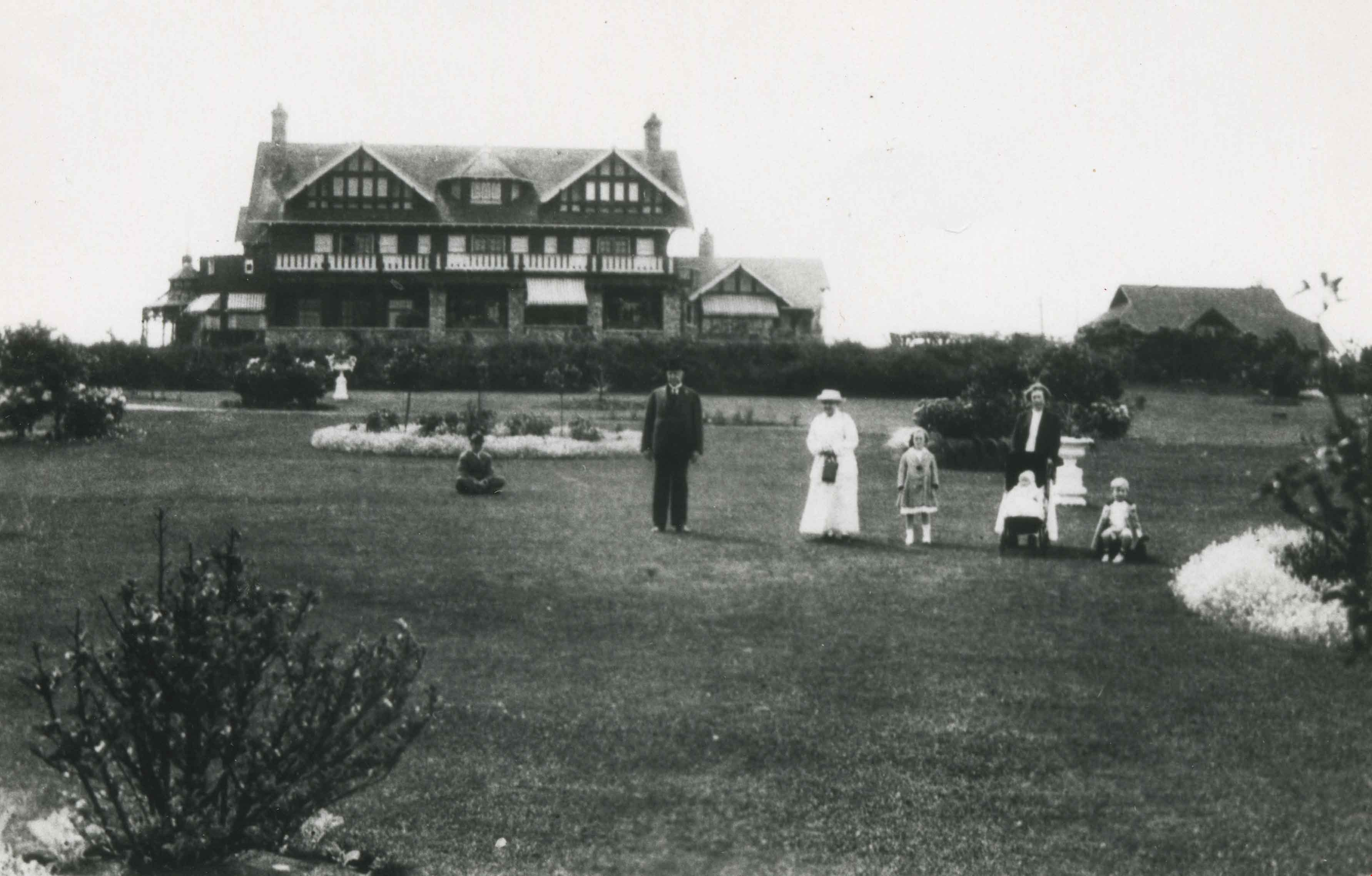
- Photograph of Fairacres Mansion, which later became the site of the Burnaby Art Gallery. The mansion was built in 1911 by Grace and Henry T. Ceperley as their retirement home. Three generations of the Ceperley family can be seen on the lawn; H.T. Ceperley, Grace Ceperley and their daughter Ethelwy…
- Repository
- City of Burnaby Archives
- Date
- 1915
- Collection/Fonds
- Burnaby Historical Society fonds
- Subseries
- Burnaby Art Gallery subseries
- Physical Description
- 1 photograph : b&w copy negative ; 4.5 x 8 cm
- Description Level
- Item
- Record No.
- 241-009
- Access Restriction
- No restrictions
- Reproduction Restriction
- No known restrictions
- Accession Number
- BHS1990-05
- Scope and Content
- Photograph of Fairacres Mansion, which later became the site of the Burnaby Art Gallery. The mansion was built in 1911 by Grace and Henry T. Ceperley as their retirement home. Three generations of the Ceperley family can be seen on the lawn; H.T. Ceperley, Grace Ceperley and their daughter Ethelwyn standing and Ethelwyn's three children; Edith Ceperley (standing), James Edward "Junior" (sitting) and Florence Renn (in carriage).The man seen seated on the left in the photograph could be James Edward Hall (Ethelwyn's husband).
- Media Type
- Photograph
- Notes
- Title based on contents of photograph 1 b&w copy print accompanying
- Geographic Access
- Deer Lake Avenue
- Street Address
- 6344 Deer Lake Avenue
- Historic Neighbourhood
- Burnaby Lake (Historic Neighbourhood)
- Planning Study Area
- Douglas-Gilpin Area
Images

Farrington Chicken Ranch
https://search.heritageburnaby.ca/link/archivedescription35226
- Repository
- City of Burnaby Archives
- Date
- 1920 (date of original), copied 1986
- Collection/Fonds
- Burnaby Historical Society fonds
- Description Level
- Item
- Physical Description
- 1 photograph : b&w ; 12.7 x 17.8 cm print
- Scope and Content
- Photograph of the Farrington brothers' chicken ranch near Central Park at 3907 Chesham Avenue (later renumbered 5384 Chesham Avenue). Brothers Thomas Farrington and Richard Farrington founded Wheat Sheaf Poultry Ranch in 1919. The laying house is at the left, and the family home is at the right.
- Repository
- City of Burnaby Archives
- Date
- 1920 (date of original), copied 1986
- Collection/Fonds
- Burnaby Historical Society fonds
- Subseries
- Pioneer Tales subseries
- Physical Description
- 1 photograph : b&w ; 12.7 x 17.8 cm print
- Description Level
- Item
- Record No.
- 204-083
- Access Restriction
- No restrictions
- Reproduction Restriction
- No known restrictions
- Accession Number
- BHS1988-03
- Scope and Content
- Photograph of the Farrington brothers' chicken ranch near Central Park at 3907 Chesham Avenue (later renumbered 5384 Chesham Avenue). Brothers Thomas Farrington and Richard Farrington founded Wheat Sheaf Poultry Ranch in 1919. The laying house is at the left, and the family home is at the right.
- Subjects
- Buildings - Agricultural
- Animals - Poultry
- Agriculture - Poultry
- Buildings - Residential - Houses
- Media Type
- Photograph
- Notes
- Title based on contents of photograph
- Geographic Access
- Chesham Avenue
- Street Address
- 5384 Chesham Avenue
- Historic Neighbourhood
- Central Park (Historic Neighbourhood)
- Planning Study Area
- Garden Village Area
Images

![Floden House, [2001] thumbnail](/media/hpo/_Data/_Archives_Images/_Unrestricted/535/535-1543.jpg?width=280)
Floden House
https://search.heritageburnaby.ca/link/archivedescription95680
- Repository
- City of Burnaby Archives
- Date
- [2001]
- Collection/Fonds
- Burnaby NewsLeader photograph collection
- Description Level
- Item
- Physical Description
- 1 photograph (tiff) : col.
- Scope and Content
- Photograph of Rolf Floden standing in front of Floden House on 18th Ave, prior to its heritage designation and its relocation by the City of Burnaby to 4th Avenue.
- Repository
- City of Burnaby Archives
- Date
- [2001]
- Collection/Fonds
- Burnaby NewsLeader photograph collection
- Physical Description
- 1 photograph (tiff) : col.
- Description Level
- Item
- Record No.
- 535-1543
- Access Restriction
- No restrictions
- Reproduction Restriction
- No restrictions
- Accession Number
- 2018-12
- Scope and Content
- Photograph of Rolf Floden standing in front of Floden House on 18th Ave, prior to its heritage designation and its relocation by the City of Burnaby to 4th Avenue.
- Media Type
- Photograph
- Photographer
- Bartel, Mario
- Notes
- Title based on caption
- Collected by editorial for use in a January 2001 issue of the Burnaby NewsLeader
- Caption from metadata: "Rolf Floden visits the house on 18th Ave. where he grew up. The house has been purchased by the city of Burnaby and will be moved to another site to be preserved."
- Geographic Access
- 18th Avenue
- Street Address
- 7244 4th Street
- Historic Neighbourhood
- East Burnaby (Historic Neighbourhood)
- Planning Study Area
- Edmonds Area
Images
![Floden House, [2001] thumbnail](/media/hpo/_Data/_Archives_Images/_Unrestricted/535/535-1543.jpg)
![Floden House auction, [2003] thumbnail](/media/hpo/_Data/_Archives_Images/_Unrestricted/535/535-1827.jpg?width=280)
Floden House auction
https://search.heritageburnaby.ca/link/archivedescription96127
- Repository
- City of Burnaby Archives
- Date
- [2003]
- Collection/Fonds
- Burnaby NewsLeader photograph collection
- Description Level
- Item
- Physical Description
- 1 photograph (tiff) : col.
- Scope and Content
- Photograph of Helen Krenzler, City of Burnaby property negotiator, standing in front of the heritage home Floden House and a sign that reads: "City of Burnaby / For Sale by Public Tender / Viewing by Appointment / Minimum Bid Price $295,000.00". Krenzler holds a banker's box that contains an antiqu…
- Repository
- City of Burnaby Archives
- Date
- [2003]
- Collection/Fonds
- Burnaby NewsLeader photograph collection
- Physical Description
- 1 photograph (tiff) : col.
- Description Level
- Item
- Record No.
- 535-1827
- Access Restriction
- No restrictions
- Reproduction Restriction
- No restrictions
- Accession Number
- 2018-12
- Scope and Content
- Photograph of Helen Krenzler, City of Burnaby property negotiator, standing in front of the heritage home Floden House and a sign that reads: "City of Burnaby / For Sale by Public Tender / Viewing by Appointment / Minimum Bid Price $295,000.00". Krenzler holds a banker's box that contains an antique light fixture.
- Media Type
- Photograph
- Photographer
- Bartel, Mario
- Notes
- Title based on caption
- Collected by editorial for use in a January 2003 issue of the Burnaby NewsLeader
- Caption from metadata: "Helen Krenzler, the City of Burnaby's property negotiator, returns some antique light fixtures to the old Floden House, in preparation for an open house for prospective buyers. The City is auctioning the heritage home after moving it to a new location last year."
- Geographic Access
- 4th Street
- Street Address
- 7244 4th Street
- Historic Neighbourhood
- East Burnaby (Historic Neighbourhood)
- Planning Study Area
- Edmonds Area
Images
![Floden House auction, [2003] thumbnail](/media/hpo/_Data/_Archives_Images/_Unrestricted/535/535-1827.jpg)
![Floden House relocation, [2001] thumbnail](/media/hpo/_Data/_Archives_Images/_Unrestricted/535/535-1628.jpg?width=280)
Floden House relocation
https://search.heritageburnaby.ca/link/archivedescription95803
- Repository
- City of Burnaby Archives
- Date
- [2001]
- Collection/Fonds
- Burnaby NewsLeader photograph collection
- Description Level
- Item
- Physical Description
- 1 photograph (tiff) : col.
- Scope and Content
- Photograph of the relocation of Floden House, a heritage home built in 1929. A man in a hard hat stands in the foreground, directing the flatbed truck that is carrying the two-storey location to its new location on 4th Street.
- Repository
- City of Burnaby Archives
- Date
- [2001]
- Collection/Fonds
- Burnaby NewsLeader photograph collection
- Physical Description
- 1 photograph (tiff) : col.
- Description Level
- Item
- Record No.
- 535-1628
- Access Restriction
- No restrictions
- Reproduction Restriction
- No restrictions
- Accession Number
- 2018-12
- Scope and Content
- Photograph of the relocation of Floden House, a heritage home built in 1929. A man in a hard hat stands in the foreground, directing the flatbed truck that is carrying the two-storey location to its new location on 4th Street.
- Media Type
- Photograph
- Photographer
- Bartel, Mario
- Notes
- Title based on caption
- Collected by editorial for use in a February 2001 issue of the Burnaby NewsLeader
- Caption from metadata: "Garry Hands, of Nickel Brothers, directs the delicate task of moving the Floden house along 4th Street in Burnaby to its new resting place further west on the street."
- Geographic Access
- 4th Street
- Street Address
- 7244 4th Street
- Historic Neighbourhood
- East Burnaby (Historic Neighbourhood)
- Planning Study Area
- Edmonds Area
Images
![Floden House relocation, [2001] thumbnail](/media/hpo/_Data/_Archives_Images/_Unrestricted/535/535-1628.jpg)
Floor finishing
https://search.heritageburnaby.ca/link/museumdescription12138
- Repository
- Burnaby Village Museum
- Date
- 1998
- Collection/Fonds
- Burnaby Village Museum fonds
- Description Level
- Item
- Physical Description
- 1 photograph : col. ; 15 x 10 cm
- Scope and Content
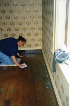
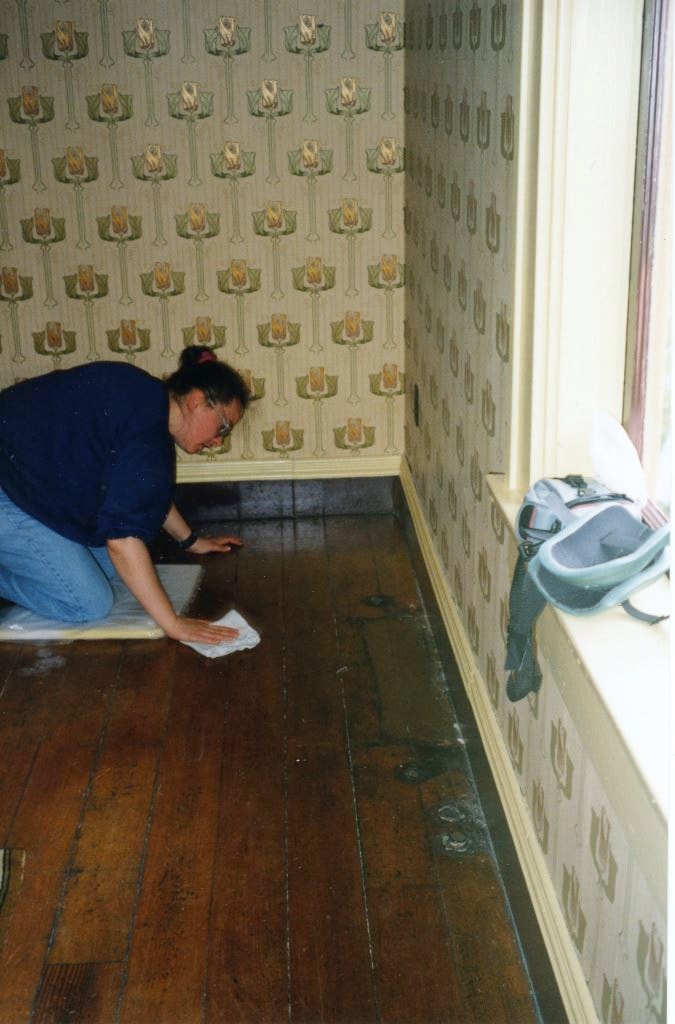
- Photograph of the parlour floor being buffed after waxing inside of the Jesse Love farmhouse.
- Repository
- Burnaby Village Museum
- Collection/Fonds
- Burnaby Village Museum fonds
- Series
- Jesse Love farmhouse series
- Description Level
- Item
- Physical Description
- 1 photograph : col. ; 15 x 10 cm
- Scope and Content
- Photograph of the parlour floor being buffed after waxing inside of the Jesse Love farmhouse.
- Names
- Burnaby Village Museum
- Accession Code
- BV018.41.957
- Access Restriction
- No restrictions
- Reproduction Restriction
- May be restricted by third party rights
- Date
- 1998
- Media Type
- Photograph
- Related Material
- See BV018.41.85 for File level description
- Scan Resolution
- 600
- Scan Date
- 04-Nov-19
- Photographer
- Langlet, Lisa
- Notes
- Title based on contents of photograph
- 1 col. photograph negative accompanying print; Part of Farmhouse restoration photographs -Book 3 - BV018.41.85
Images
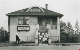
![Forster family house and store, [1924] (date of original), copied 1986 thumbnail](/media/hpo/_Data/_Archives_Images/_Unrestricted/126/168-007.jpg?width=280)
Forster family house and store
https://search.heritageburnaby.ca/link/archivedescription34972
- Repository
- City of Burnaby Archives
- Date
- [1924] (date of original), copied 1986
- Collection/Fonds
- Burnaby Historical Society fonds
- Description Level
- Item
- Physical Description
- 1 photograph : b&w ; 12.5 x 8.8 cm print
- Scope and Content
- Photograph of Wilson Forster's plumbing and electrical business and the Forster family home at 2849 McKay Avenue (later renumbered 6208 McKay Avenue).
- Repository
- City of Burnaby Archives
- Date
- [1924] (date of original), copied 1986
- Collection/Fonds
- Burnaby Historical Society fonds
- Subseries
- Forster family subseries
- Physical Description
- 1 photograph : b&w ; 12.5 x 8.8 cm print
- Description Level
- Item
- Record No.
- 168-007
- Access Restriction
- No restrictions
- Reproduction Restriction
- No known restrictions
- Accession Number
- BHS1986-17
- Scope and Content
- Photograph of Wilson Forster's plumbing and electrical business and the Forster family home at 2849 McKay Avenue (later renumbered 6208 McKay Avenue).
- Media Type
- Photograph
- Notes
- Title based on contents of photograph
- Geographic Access
- McKay Avenue
- Street Address
- 6208 McKay Avenue
- Historic Neighbourhood
- Central Park (Historic Neighbourhood)
- Planning Study Area
- Maywood Area
Images
![Forster family house and store, [1924] (date of original), copied 1986 thumbnail](/media/hpo/_Data/_Archives_Images/_Unrestricted/126/168-007.jpg)
![Forster family house and store, [1930] (date of original), copied 1986 thumbnail](/media/hpo/_Data/_Archives_Images/_Unrestricted/126/168-008.jpg?width=280)
Forster family house and store
https://search.heritageburnaby.ca/link/archivedescription34973
- Repository
- City of Burnaby Archives
- Date
- [1930] (date of original), copied 1986
- Collection/Fonds
- Burnaby Historical Society fonds
- Description Level
- Item
- Physical Description
- 1 photograph : b&w ; 8.8 x 12.5 cm print
- Scope and Content
- Photograph of Wilson Forster's plumbing and electrical business and the Forster family home at 2849 McKay Avenue after a snowfall (later renumbered 6208 McKay Avenue).
- Repository
- City of Burnaby Archives
- Date
- [1930] (date of original), copied 1986
- Collection/Fonds
- Burnaby Historical Society fonds
- Subseries
- Forster family subseries
- Physical Description
- 1 photograph : b&w ; 8.8 x 12.5 cm print
- Description Level
- Item
- Record No.
- 168-008
- Access Restriction
- No restrictions
- Reproduction Restriction
- No known restrictions
- Accession Number
- BHS1986-17
- Scope and Content
- Photograph of Wilson Forster's plumbing and electrical business and the Forster family home at 2849 McKay Avenue after a snowfall (later renumbered 6208 McKay Avenue).
- Media Type
- Photograph
- Notes
- Title based on contents of photograph
- Geographic Access
- McKay Avenue
- Street Address
- 6208 McKay Avenue
- Historic Neighbourhood
- Central Park (Historic Neighbourhood)
- Planning Study Area
- Maywood Area
Images
![Forster family house and store, [1930] (date of original), copied 1986 thumbnail](/media/hpo/_Data/_Archives_Images/_Unrestricted/126/168-008.jpg)
Forster House and Business
https://search.heritageburnaby.ca/link/archivedescription36789
- Repository
- City of Burnaby Archives
- Date
- 1924 (date of original), copied 1992
- Collection/Fonds
- Burnaby Historical Society fonds
- Description Level
- Item
- Physical Description
- 1 photograph : b&w ; 8.0 x 12.6 cm print
- Scope and Content
- Photograph of the Forster family home at 2849 McKay Avenue (old street number) also housing Wilson Forster's plumbing and electrical business. A group of girls are sitting on the front steps.
- Repository
- City of Burnaby Archives
- Date
- 1924 (date of original), copied 1992
- Collection/Fonds
- Burnaby Historical Society fonds
- Subseries
- Burnaby Centennial Anthology subseries
- Physical Description
- 1 photograph : b&w ; 8.0 x 12.6 cm print
- Description Level
- Item
- Record No.
- 315-246
- Access Restriction
- No restrictions
- Reproduction Restriction
- No known restrictions
- Accession Number
- BHS1994-04
- Scope and Content
- Photograph of the Forster family home at 2849 McKay Avenue (old street number) also housing Wilson Forster's plumbing and electrical business. A group of girls are sitting on the front steps.
- Media Type
- Photograph
- Notes
- Title based on contents of photograph
- Geographic Access
- McKay Avenue
- Street Address
- 6208 McKay Avenue
- Historic Neighbourhood
- Central Park (Historic Neighbourhood)
- Planning Study Area
- Maywood Area
Images

![Forster House and Business, [193-] (date of original), copied 1992 thumbnail](/media/hpo/_Data/_Archives_Images/_Unrestricted/315/315-247.jpg?width=280)
Forster House and Business
https://search.heritageburnaby.ca/link/archivedescription36790
- Repository
- City of Burnaby Archives
- Date
- [193-] (date of original), copied 1992
- Collection/Fonds
- Burnaby Historical Society fonds
- Description Level
- Item
- Physical Description
- 1 photograph : b&w ; 8.5 x 12.6 cm print
- Scope and Content
- Photograph of the Forster family home at 2849 McKay Avenue (old street number) with Wilson Forster's plumbing and electrical shop attached. Originally the business was located in the residence. A group of adults and children are on the front steps of the house.
- Repository
- City of Burnaby Archives
- Date
- [193-] (date of original), copied 1992
- Collection/Fonds
- Burnaby Historical Society fonds
- Subseries
- Burnaby Centennial Anthology subseries
- Physical Description
- 1 photograph : b&w ; 8.5 x 12.6 cm print
- Description Level
- Item
- Record No.
- 315-247
- Access Restriction
- No restrictions
- Reproduction Restriction
- No known restrictions
- Accession Number
- BHS1994-04
- Scope and Content
- Photograph of the Forster family home at 2849 McKay Avenue (old street number) with Wilson Forster's plumbing and electrical shop attached. Originally the business was located in the residence. A group of adults and children are on the front steps of the house.
- Media Type
- Photograph
- Notes
- Title based on contents of photograph
- Geographic Access
- McKay Avenue
- Street Address
- 6208 McKay Avenue
- Historic Neighbourhood
- Central Park (Historic Neighbourhood)
- Planning Study Area
- Maywood Area
Images
![Forster House and Business, [193-] (date of original), copied 1992 thumbnail](/media/hpo/_Data/_Archives_Images/_Unrestricted/315/315-247.jpg)

Front hallway entrance of Love farmhouse
https://search.heritageburnaby.ca/link/museumdescription1122
- Repository
- Burnaby Village Museum
- Date
- 1971 (date of original), copied 1990
- Collection/Fonds
- Love family fonds
- Description Level
- Item
- Physical Description
- 1 photograph : col. ; 15 x 10 cm print
- Scope and Content
- Photograph of the front hallway and entrance door of the Love farmhouse while Elsie (nee Love) Hughes, her husband John and son Brent lived in the house. The house was located at 7651 Cumberland Street (Address pre 1960: 1390 Cumberland Road) and was moved from its original site to the Burnaby Vill…
- Repository
- Burnaby Village Museum
- Collection/Fonds
- Love family fonds
- Description Level
- Item
- Physical Description
- 1 photograph : col. ; 15 x 10 cm print
- Material Details
- Copy print was made from re-photographing an original colour slide
- Scope and Content
- Photograph of the front hallway and entrance door of the Love farmhouse while Elsie (nee Love) Hughes, her husband John and son Brent lived in the house. The house was located at 7651 Cumberland Street (Address pre 1960: 1390 Cumberland Road) and was moved from its original site to the Burnaby Village Museum in 1988 and designated a Municipal Heritage Landmark in 1992.
- Geographic Access
- Cumberland Street
- Street Address
- 7651 Cumberland Street
- Accession Code
- BV992.15.3
- Access Restriction
- Restricted access
- Reproduction Restriction
- May be restricted by third party rights
- Date
- 1971 (date of original), copied 1990
- Media Type
- Photograph
- Historic Neighbourhood
- East Burnaby (Historic Neighbourhood)
- Planning Study Area
- Cariboo-Armstrong Area
- Scan Resolution
- 600
- Scan Date
- 01-Jun-09
- Scale
- 100
- Photographer
- Parker, Albert "Bert"
- Notes
- Title based on contents of photograph
Images
