More like 'Dad at Deer Lake'
Narrow Results By
Decade
- 2020s 40
- 2010s 41
- 2000s 354
- 1990s 364
- 1980s 179
- 1970s 349
- 1960s 267
- 1950s 289
- 1940s 392
- 1930s 291
- 1920s 348
- 1910s 401
- 1900s 221
- 1890s 39
- 1880s 8
- 1870s 3
- 1860s 3
- 1850s 2
- 1840s 1
- 1830s 1
- 1820s 1
- 1810s 2
- 1800s 2
- 1790s 2
- 1780s 2
- 1770s 2
- 1760s 2
- 1750s 2
- 1740s 2
- 1730s 2
- 1720s 2
- 1710s 2
- 1700s 2
- 1690s 2
- 1680s 2
- 1670s 2
- 1660s 2
- 1650s 2
- 1640s 2
- 1630s 2
- 1620s 2
- 1610s 2
- 1600s 2
- 1590s 1
- 1580s 1
- 1570s 1
- 1560s 1
- 1550s 1
- 1540s 1
- 1530s 1
- 1520s 1
- 1510s 1
- 1500s 1
- 1490s 1
- 1480s 1
Subject
- Academic Disciplines 1
- Accidents 5
- Accidents - Automobile Accidents 11
- Adornment 3
- Adornment - Jewelry 2
- Adornment - Lapel Pins 4
- Advertising Medium 16
- Advertising Medium - Business Cards 8
- Advertising Medium - Flyer 2
- Advertising Medium - Signs and Signboards 11
- Aerial Photographs 1
- Agricultural Tools and Equipment 28
Creator
- Allan Studios 2
- Anders, F. 1
- Anders, Fred 1
- Association for Living Historical Farms and Agricultural Museums, U.S.A. 1
- Association for Living History, Farm and Agricultural Museums 5
- Atkinson, J. C. (John Christopher), 1814-1900 1
- Baron Studios 1
- Barrowclough, G.A. 3
- Barrowclough, George Alfred 4
- Bartel, Mario 326
- Battersby, Frank 16
- Battistoni, Peter 32
![Tom, [1905] thumbnail](/media/hpo/_Data/_Archives_Images/_Unrestricted/477/477-851.jpg?width=280)
Tom
https://search.heritageburnaby.ca/link/archivedescription39532
- Repository
- City of Burnaby Archives
- Date
- [1905]
- Collection/Fonds
- Peers Family and Hill Family fonds
- Description Level
- Item
- Physical Description
- 1 photograph : b&w ; 5.5 x 5.5 cm on page 21.5 x 28 cm (pasted in album)
- Scope and Content
- Photograph of the Hill family horse, Tom, standing outside a barn at the Hill farm. The Hill family home was known as Brookfield and occupied the current site of the Burnaby Village Museum on Deer Lake Avenue.
- Repository
- City of Burnaby Archives
- Date
- [1905]
- Collection/Fonds
- Peers Family and Hill Family fonds
- Physical Description
- 1 photograph : b&w ; 5.5 x 5.5 cm on page 21.5 x 28 cm (pasted in album)
- Description Level
- Item
- Record No.
- 477-851
- Access Restriction
- No restrictions
- Reproduction Restriction
- No known restrictions
- Accession Number
- 2007-12
- Scope and Content
- Photograph of the Hill family horse, Tom, standing outside a barn at the Hill farm. The Hill family home was known as Brookfield and occupied the current site of the Burnaby Village Museum on Deer Lake Avenue.
- Media Type
- Photograph
- Notes
- Title based on contents of photograph
- Geographic Access
- Deer Lake Avenue
- Street Address
- 6501 Deer Lake Avenue
- Historic Neighbourhood
- Burnaby Lake (Historic Neighbourhood)
- Planning Study Area
- Morley-Buckingham Area
Images
![Tom, [1905] thumbnail](/media/hpo/_Data/_Archives_Images/_Unrestricted/477/477-851.jpg)
![Claude Hill leading a cow, [1910] thumbnail](/media/hpo/_Data/_Archives_Images/_Unrestricted/477/477-075.jpg?width=280)
Claude Hill leading a cow
https://search.heritageburnaby.ca/link/archivedescription38756
- Repository
- City of Burnaby Archives
- Date
- [1910]
- Collection/Fonds
- Peers Family and Hill Family fonds
- Description Level
- Item
- Physical Description
- 1 photograph : b&w ; 5 x 8 cm on page 11.5 x 14 cm (pasted in album)
- Scope and Content
- Photograph of Claude Hill leading a cow with a rope. The photograph was likely taken at the Hill family home, known as Broadview, on Buckingham Avenue.
- Repository
- City of Burnaby Archives
- Date
- [1910]
- Collection/Fonds
- Peers Family and Hill Family fonds
- Physical Description
- 1 photograph : b&w ; 5 x 8 cm on page 11.5 x 14 cm (pasted in album)
- Description Level
- Item
- Record No.
- 477-075
- Access Restriction
- No restrictions
- Reproduction Restriction
- No known restrictions
- Accession Number
- 2007-12
- Scope and Content
- Photograph of Claude Hill leading a cow with a rope. The photograph was likely taken at the Hill family home, known as Broadview, on Buckingham Avenue.
- Subjects
- Animals - Cows
- Occupations - Farmers
- Media Type
- Photograph
- Notes
- Title based on contents of photograph
- Geographic Access
- Buckingham Avenue
- Street Address
- 5730 Buckingham Avenue
- Historic Neighbourhood
- Burnaby Lake (Historic Neighbourhood)
- Planning Study Area
- Morley-Buckingham Area
Images
![Claude Hill leading a cow, [1910] thumbnail](/media/hpo/_Data/_Archives_Images/_Unrestricted/477/477-075.jpg)
![Dad at Deer Lake, [1905] thumbnail](/media/hpo/_Data/_Archives_Images/_Unrestricted/477/477-182.jpg?width=280)
Dad at Deer Lake
https://search.heritageburnaby.ca/link/archivedescription38863
- Repository
- City of Burnaby Archives
- Date
- [1905]
- Collection/Fonds
- Peers Family and Hill Family fonds
- Description Level
- Item
- Physical Description
- 1 photograph : sepia ; 4.5 x 7.5 cm on page 14 x 17.5 cm (pasted in album)
- Scope and Content
- Photograph of Claude Hill leading a cow along his property near Deer Lake, in the Burnaby Lake area. His daughter, Kitty, wrote the caption "Dad at Deer Lake" next to this photograph.
- Repository
- City of Burnaby Archives
- Date
- [1905]
- Collection/Fonds
- Peers Family and Hill Family fonds
- Physical Description
- 1 photograph : sepia ; 4.5 x 7.5 cm on page 14 x 17.5 cm (pasted in album)
- Description Level
- Item
- Record No.
- 477-182
- Access Restriction
- No restrictions
- Reproduction Restriction
- No known restrictions
- Accession Number
- 2007-12
- Scope and Content
- Photograph of Claude Hill leading a cow along his property near Deer Lake, in the Burnaby Lake area. His daughter, Kitty, wrote the caption "Dad at Deer Lake" next to this photograph.
- Subjects
- Animals - Cows
- Occupations - Farmers
- Media Type
- Photograph
- Notes
- Title based on caption accompanying photograph
- Geographic Access
- Douglas Road
- Deer Lake Avenue
- Street Address
- 6501 Deer Lake Avenue
- Historic Neighbourhood
- Burnaby Lake (Historic Neighbourhood)
- Planning Study Area
- Morley-Buckingham Area
Images
![Dad at Deer Lake, [1905] thumbnail](/media/hpo/_Data/_Archives_Images/_Unrestricted/477/477-182.jpg)
Interview with Reidun Seim by Kathy Bossort January 13, 2016 - Track 3
https://search.heritageburnaby.ca/link/oralhistory652
- Repository
- City of Burnaby Archives
- Date Range
- 1934-1990
- Length
- 0:15:30
- Summary
- This portion of the interview is about Reidun Seim talking about her father’s chicken farm. She describes the farm buildings, other animals on the farm, and how her father operated the chicken farm, especially his approach to keeping the chickens disease free. She also talks about cutting down the …
- Repository
- City of Burnaby Archives
- Summary
- This portion of the interview is about Reidun Seim talking about her father’s chicken farm. She describes the farm buildings, other animals on the farm, and how her father operated the chicken farm, especially his approach to keeping the chickens disease free. She also talks about cutting down the alder at the back of the property for the chicken run, and building rock walls and a driveway with rocks taken off the property. She also describes how the property was subdivided in the 1980s.
- Date Range
- 1934-1990
- Length
- 0:15:30
- Subjects
- Occupations - Farmers
- Animals - Poultry
- Geographic Access
- Curtis Street
- Historic Neighbourhood
- Lochdale (Historic Neighbourhood)
- Planning Study Area
- Lochdale Area
- Interviewer
- Bossort, Kathy
- Interview Date
- January 13, 2016
- Scope and Content
- Recording is of an interview with Reidun Seim conducted by Kathy Bossort. Reidun Seim was one of 23 participants interviewed as part of the Community Heritage Commission’s Burnaby Mountain Oral History Project. The interview is mainly about Reidun Seim’s memories about her parent’s farm on Curtis Street, events in her childhood, and the people who lived in or visited her neighborhood. She takes us on a tour of her neighborhood in the 1940s, telling us stories about families who lived on Curtis Street on and east of 7300 block, including people who lived on Burnaby Mountain in the old Hastings Grove subdivision above the end of municipal water service at Philips Avenue. She describes changes to Curtis Street, particularly after it provided access to Simon Fraser University in 1965. She also talks about her teaching career, and about how she values the green space and conservation area on Burnaby Mountain.
- Biographical Notes
- Reidun Seim was born in 1931 in Vancouver B.C. to Sjur and Martine Seim. Sjur and Martine Seim emigrated to Canada from Norway in 1930, and after settling in Vancouver, moved to an acre of land and a new home at the base of Burnaby Mountain in 1932. Sjur attended UBC to learn about poultry farming and began his own chicken and egg business in 1935. The farm animals and large garden also contributed to the family’s livelihood and self-sufficiency. The Curtis Street neighborhood was a lively place and extended well up Curtis Street on the west slope of Burnaby Mountain, where Reidun would babysit for families. Reidun attended Sperling Avenue Elementary School (Gr. 1-8), Burnaby North High School, and Vancouver Normal School for teacher training in 1950-1951. She began teaching primary grades in Port Coquitlam at James Park School. Most of her career was spent in North Delta, teaching at Kennedy and Annieville schools from 1954-1958, appointed Primary Consultant (1958-1960) and Primary Supervisor (1960-1985), before retiring in 1986. Reidun lived at home with her parents on Curtis Street, commuting to Delta, and continues to live in the original farmhouse.
- Total Tracks
- 14
- Total Length
- 2:35:58
- Interviewee Name
- Seim, Reidun
- Interview Location
- Burnaby City Hall in the Law Library
- Interviewer Bio
- Kathy Bossort is a retired archivist living in Ladner, BC. She worked at the Delta Museum and Archives after graduating from SLAIS (UBC) in 2001 with Masters degrees in library science and archival studies. Kathy grew up in Calgary, Alberta, and, prior to this career change, she lived in the West Kootenays, earning her living as a cook for BC tourist lodges and work camps. She continues to be interested in oral histories as a way to fill the gaps in the written record and bring richer meaning to history.
- Collection/Fonds
- Community Heritage Commission Special Projects fonds
- Media Type
- Sound Recording
Audio Tracks
Track three of interview with Reidun Seim
Track three of interview with Reidun Seim
https://search.heritageburnaby.ca/media/hpo/_Data/_Archives_Oral_Histories/_Unrestricted/MSS196-017/MSS196-017_Track_3.mp3
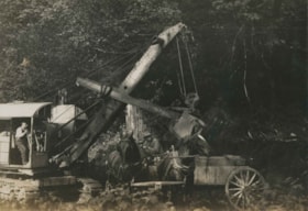
Digging In
https://search.heritageburnaby.ca/link/archivedescription34387
- Repository
- City of Burnaby Archives
- Date
- 1926
- Collection/Fonds
- Burnaby Historical Society fonds
- Description Level
- Item
- Physical Description
- 1 photograph : b&w ; 7.5 x 7 cm on page 17.5 x 26.5 cm
- Scope and Content
- Photograph of a steam shovel digging into a hill. A horse team pulling a dump wagon stand next to it. The location is unknown. This photograph appears to have been taken by Arthur Peers, who travelled through the Fraser River Valley and worked on the construction of the Trans-Provincial Highway dur…
- Repository
- City of Burnaby Archives
- Date
- 1926
- Collection/Fonds
- Burnaby Historical Society fonds
- Subseries
- Peers family subseries
- Physical Description
- 1 photograph : b&w ; 7.5 x 7 cm on page 17.5 x 26.5 cm
- Description Level
- Item
- Record No.
- 020-094
- Access Restriction
- No restrictions
- Reproduction Restriction
- No known restrictions
- Accession Number
- BHS2007-04
- Scope and Content
- Photograph of a steam shovel digging into a hill. A horse team pulling a dump wagon stand next to it. The location is unknown. This photograph appears to have been taken by Arthur Peers, who travelled through the Fraser River Valley and worked on the construction of the Trans-Provincial Highway during the later 1920s.
- Subjects
- Land Clearing
- Occupations - Labourers
- Transportation - Horses
- Transportation - Wagons
- Construction Tools and Equipment
- Media Type
- Photograph
- Photographer
- Peers, Arthur Francis "Mike"
- Notes
- Title based on caption accompanying photograph
Images

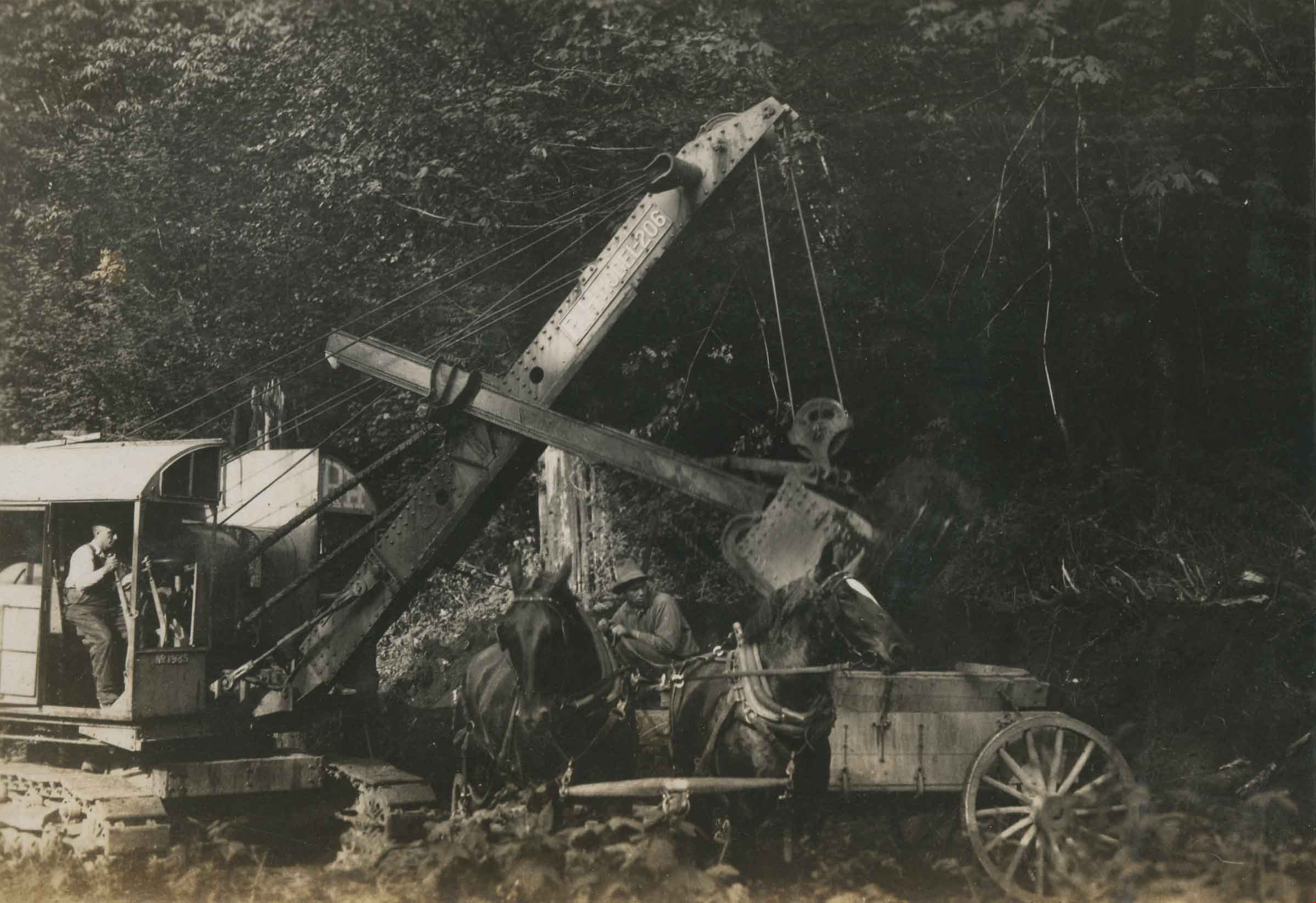
Loading a dump wagon
https://search.heritageburnaby.ca/link/archivedescription34383
- Repository
- City of Burnaby Archives
- Date
- 1926
- Collection/Fonds
- Burnaby Historical Society fonds
- Description Level
- Item
- Physical Description
- 1 photograph : b&w ; 7.1 x 10.2 cm on page 17.5 x 26.5 cm
- Scope and Content
- Photograph of a man using a steam shovel to load a dump wagon which is being pulled by a team of horses. Another man can be seen sitting on the wagon. Both are unidentified. This photograph appears to have been taken by Arthur Peers, who travelled through the Fraser River Valley and worked on the c…
- Repository
- City of Burnaby Archives
- Date
- 1926
- Collection/Fonds
- Burnaby Historical Society fonds
- Subseries
- Peers family subseries
- Physical Description
- 1 photograph : b&w ; 7.1 x 10.2 cm on page 17.5 x 26.5 cm
- Description Level
- Item
- Record No.
- 020-090
- Access Restriction
- No restrictions
- Reproduction Restriction
- No known restrictions
- Accession Number
- BHS2007-04
- Scope and Content
- Photograph of a man using a steam shovel to load a dump wagon which is being pulled by a team of horses. Another man can be seen sitting on the wagon. Both are unidentified. This photograph appears to have been taken by Arthur Peers, who travelled through the Fraser River Valley and worked on the construction of the Trans-Provincial Highway during the later 1920s.
- Subjects
- Occupations - Labourers
- Transportation - Horses
- Transportation - Wagons
- Construction Tools and Equipment
- Media Type
- Photograph
- Photographer
- Peers, Arthur Francis "Mike"
- Notes
- Title based on caption accompanying photograph
Images
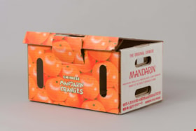
Box
https://search.heritageburnaby.ca/link/museumartifact89918
- Repository
- Burnaby Village Museum
- Accession Code
- BV019.6.1
- Description
- box; to ship and sell mandarin oranges; rectangular, corrugated cardboard box; single piece of cardboard, folded to form box; locking tab lid; oval cut outs in sides and lid for air circulation and for carrying; interior is plain brown cardboard; exterior has white, orange, and green text and illustrations beneath a wax coating. Colourful illustrations of mandarin oranges on sides and lid of box; text on front, back, and lid reads: "CHINESE / MANDARIN / ORANGES"; text on one side in French and other side in English reads: "THE ORIGINAL CHINESE / MANDARIN / CHINA NATIONAL CEREALS, OILS & FOODSTUFFS IMPORT & EXPORT CORPORATION / PRODUCT OF THE PEOPLE'S REPUBLIC OF CHINA / [text in Chinese] / MINIMUM 31 PCS. PER BOX"."
- Object History
- As a produce buyer for Kelly Douglas, Cecil Lee worked closely with local farmers along Marine Drive and in the Fraser Valley. The Burnaby company was one of the largest food distributors in Canada. In the mid-1970s, Lee was asked to oversee the import of Chinese mandarin oranges into Canada. Until that time, mandarin oranges had come from Japan and were sold in the winter, especially at Christmas. When the Japanese market could no longer keep up with demand, Kelly Douglas looked to China. The company relied on Lee’s cultural knowledge to build this very profitable part of their business. Lee designed the cardboard Chinese mandarin orange box to replace wooden containers. The iconic design required no glue or staples, making it possible for farmers to assemble and pack the boxes as they picked the oranges.
- Reference
- For other records in this collection see: Business records series of Julie Lee and Cecil Lee family fonds
- Category
- 04.Tools & Equipment for Materials
- Classification
- Food Processing & Preparation T&E - - Food Storage Equipment
- Object Term
- Box, Food Storage
- Subjects
- Agriculture - Fruit and Berries
- Container - Box
- Occupations - Agricultural Labourers
- Occupations - Grocers
- Names
- Lee, Julie Cho Chan
- Historic Neighbourhood
- Central Park (Historic Neighbourhood)
- Planning Study Area
- Maywood Area
Images
Barn book
https://search.heritageburnaby.ca/link/museumlibrary4912
- Repository
- Burnaby Village Museum
- Author
- Beatty Bros Limited
- Publication Date
- c1931
- Call Number
- 631 BEA
- Repository
- Burnaby Village Museum
- Collection
- Special Collection
- Material Type
- Book
- Accession Code
- BV991.45.136
- Call Number
- 631 BEA
- Author
- Beatty Bros Limited
- Place of Publication
- London
- Publisher
- Beatty Bros., Ltd.
- Publication Date
- c1931
- Physical Description
- 334 p. : ill. : 25 cm.
- Library Subject (LOC)
- Barns
- Farm buildings
- Dairying
- Stables
- Catalogs
- Subjects
- Buildings
- Buildings - Agricultural
- Buildings - Agricultural - Barns
- Agriculture
- Agriculture - Dairy
- Names
- Oakalla Prison Farm
- Object History
- Salvaged from Oakalla Prison site in October 1991
- Notes
- Includes index.

Farrington Chicken Ranch
https://search.heritageburnaby.ca/link/archivedescription35226
- Repository
- City of Burnaby Archives
- Date
- 1920 (date of original), copied 1986
- Collection/Fonds
- Burnaby Historical Society fonds
- Description Level
- Item
- Physical Description
- 1 photograph : b&w ; 12.7 x 17.8 cm print
- Scope and Content
- Photograph of the Farrington brothers' chicken ranch near Central Park at 3907 Chesham Avenue (later renumbered 5384 Chesham Avenue). Brothers Thomas Farrington and Richard Farrington founded Wheat Sheaf Poultry Ranch in 1919. The laying house is at the left, and the family home is at the right.
- Repository
- City of Burnaby Archives
- Date
- 1920 (date of original), copied 1986
- Collection/Fonds
- Burnaby Historical Society fonds
- Subseries
- Pioneer Tales subseries
- Physical Description
- 1 photograph : b&w ; 12.7 x 17.8 cm print
- Description Level
- Item
- Record No.
- 204-083
- Access Restriction
- No restrictions
- Reproduction Restriction
- No known restrictions
- Accession Number
- BHS1988-03
- Scope and Content
- Photograph of the Farrington brothers' chicken ranch near Central Park at 3907 Chesham Avenue (later renumbered 5384 Chesham Avenue). Brothers Thomas Farrington and Richard Farrington founded Wheat Sheaf Poultry Ranch in 1919. The laying house is at the left, and the family home is at the right.
- Subjects
- Buildings - Agricultural
- Animals - Poultry
- Agriculture - Poultry
- Buildings - Residential - Houses
- Media Type
- Photograph
- Notes
- Title based on contents of photograph
- Geographic Access
- Chesham Avenue
- Street Address
- 5384 Chesham Avenue
- Historic Neighbourhood
- Central Park (Historic Neighbourhood)
- Planning Study Area
- Garden Village Area
Images


Farrington Laying House
https://search.heritageburnaby.ca/link/archivedescription35227
- Repository
- City of Burnaby Archives
- Date
- 1920 (date of original), copied 1986
- Collection/Fonds
- Burnaby Historical Society fonds
- Description Level
- Item
- Physical Description
- 1 photograph : b&w ; 12.7 x 17.8 cm print
- Scope and Content
- Photograph of Farrington brothers' chicken laying house. Brothers Thomas Farrington and Richard Farrington founded Wheat Sheaf Poultry Ranch in 1919. It was located at 3907 Chesham Avenue (later renumbered 5384 Chesham Avenue).
- Repository
- City of Burnaby Archives
- Date
- 1920 (date of original), copied 1986
- Collection/Fonds
- Burnaby Historical Society fonds
- Subseries
- Pioneer Tales subseries
- Physical Description
- 1 photograph : b&w ; 12.7 x 17.8 cm print
- Description Level
- Item
- Record No.
- 204-084
- Access Restriction
- No restrictions
- Reproduction Restriction
- No known restrictions
- Accession Number
- BHS1988-03
- Scope and Content
- Photograph of Farrington brothers' chicken laying house. Brothers Thomas Farrington and Richard Farrington founded Wheat Sheaf Poultry Ranch in 1919. It was located at 3907 Chesham Avenue (later renumbered 5384 Chesham Avenue).
- Media Type
- Photograph
- Notes
- Title based on contents of photograph
- Geographic Access
- Chesham Avenue
- Street Address
- 5384 Chesham Avenue
- Historic Neighbourhood
- Central Park (Historic Neighbourhood)
- Planning Study Area
- Garden Village Area
Images


Olive Farrington Barber
https://search.heritageburnaby.ca/link/archivedescription35225
- Repository
- City of Burnaby Archives
- Date
- 1928 (date of original), copied 1986
- Collection/Fonds
- Burnaby Historical Society fonds
- Description Level
- Item
- Physical Description
- 1 photograph : b&w ; 12.7 x 17.8 cm print
- Scope and Content
- Photograph of Olive Farrington Barber in front of the Farrington brothers' chicken shed. Brothers Thomas Farrington and Richard Farrington founded Wheat Sheaf Poultry Ranch in 1919. It was located at 3907 Chesham Avenue (later renumbered 5384 Chesham Avenue).
- Repository
- City of Burnaby Archives
- Date
- 1928 (date of original), copied 1986
- Collection/Fonds
- Burnaby Historical Society fonds
- Subseries
- Pioneer Tales subseries
- Physical Description
- 1 photograph : b&w ; 12.7 x 17.8 cm print
- Description Level
- Item
- Record No.
- 204-082
- Access Restriction
- No restrictions
- Reproduction Restriction
- No known restrictions
- Accession Number
- BHS1988-03
- Scope and Content
- Photograph of Olive Farrington Barber in front of the Farrington brothers' chicken shed. Brothers Thomas Farrington and Richard Farrington founded Wheat Sheaf Poultry Ranch in 1919. It was located at 3907 Chesham Avenue (later renumbered 5384 Chesham Avenue).
- Media Type
- Photograph
- Notes
- Title based on contents of photograph
- Geographic Access
- Chesham Avenue
- Street Address
- 5384 Chesham Avenue
- Historic Neighbourhood
- Central Park (Historic Neighbourhood)
- Planning Study Area
- Garden Village Area
Images

Lubbock photographs from album
https://search.heritageburnaby.ca/link/archivedescription64493
- Repository
- City of Burnaby Archives
- Date
- 1945-1988
- Collection/Fonds
- Burnaby Historical Society fonds
- Description Level
- File
- Physical Description
- 130 photographs : b&w and col. ; 20.5 x 25.5 cm or smaller
- Scope and Content
- Photographs of the Lubbock family, including their riding stables and horses, family events, their pets, and landscape and travel photographs. These photographs were originally housed in a photographic album.
- Repository
- City of Burnaby Archives
- Date
- 1945-1988
- Collection/Fonds
- Burnaby Historical Society fonds
- Subseries
- Lubbock family subseries
- Physical Description
- 130 photographs : b&w and col. ; 20.5 x 25.5 cm or smaller
- Description Level
- File
- Record No.
- 342-046
- Access Restriction
- In Archives only
- Reproduction Restriction
- May be restricted by third party rights
- Accession Number
- BHS1994-02
- Scope and Content
- Photographs of the Lubbock family, including their riding stables and horses, family events, their pets, and landscape and travel photographs. These photographs were originally housed in a photographic album.
- Names
- Lubbock, Ainsly
- Lubbock, Beatrice "Bea"
- Lubbock, Elizabeth
- Lubbock, Gordon
- Lubbock, John
- Lubbock, John Barker
- Lubbock, Mina
- Media Type
- Photograph
- Notes
- Title based on contents of photograph
- Geographic Access
- Grandview Highway
- Canada Way
- Burris Street
- Street Address
- 7803 Burris Street
- Historic Neighbourhood
- Burnaby Lake (Historic Neighbourhood)
- Planning Study Area
- Morley-Buckingham Area
![Aerial View of Chinese Market Gardens on Marine Drive, [between 1950 and 1959] (date of original), 2017 (date of duplication) thumbnail](/media/hpo/_Data/_BVM_Images/2017/2017_0040_0001_001.jpg?width=280)
Aerial View of Chinese Market Gardens on Marine Drive
https://search.heritageburnaby.ca/link/museumdescription4296
- Repository
- Burnaby Village Museum
- Date
- [between 1950 and 1959] (date of original), 2017 (date of duplication)
- Collection/Fonds
- Herbert Yee Law family fonds
- Description Level
- Item
- Physical Description
- 1 photograph (jpg) : b&w
- Scope and Content
- Photograph is an aerial view looking south over the Chinese Market Gardens along Marine Drive in the Big Bend area of Burnaby.
- Repository
- Burnaby Village Museum
- Collection/Fonds
- Herbert Yee Law family fonds
- Description Level
- Item
- Physical Description
- 1 photograph (jpg) : b&w
- Scope and Content
- Photograph is an aerial view looking south over the Chinese Market Gardens along Marine Drive in the Big Bend area of Burnaby.
- Names
- Chinese Market Gardens
- Geographic Access
- Marine Drive
- Accession Code
- BV017.40.1
- Access Restriction
- No restrictions
- Reproduction Restriction
- May be restricted by third party rights
- Date
- [between 1950 and 1959] (date of original), 2017 (date of duplication)
- Media Type
- Photograph
- Historic Neighbourhood
- Fraser Arm (Historic Neighbourhood)
- Planning Study Area
- Big Bend Area
- Scan Resolution
- 600
- Scan Date
- 11/19/2017
- Scale
- 100
- Notes
- Title based on contents of photograph.
Images
![Aerial View of Chinese Market Gardens on Marine Drive, [between 1950 and 1959] (date of original), 2017 (date of duplication) thumbnail](/media/hpo/_Data/_BVM_Images/2017/2017_0040_0001_001.jpg)

Chinese Market Gardens
https://search.heritageburnaby.ca/link/archivedescription70542
- Repository
- City of Burnaby Archives
- Date
- 1949
- Collection/Fonds
- Gail Yip fonds
- Description Level
- Item
- Physical Description
- 1 photograph (jpeg) : b&w
- Scope and Content
- Photograph is an aerial view looking south over the Chinese Market Gardens along Marine Drive. The farm on the south side of Marine Drive, second from the east, is 4930 Marine Drive.
- Repository
- City of Burnaby Archives
- Date
- 1949
- Collection/Fonds
- Gail Yip fonds
- Physical Description
- 1 photograph (jpeg) : b&w
- Description Level
- Item
- Record No.
- 529-001
- Access Restriction
- No restrictions
- Reproduction Restriction
- Reproduce for fair dealing purposes only
- Accession Number
- 2012-04
- Scope and Content
- Photograph is an aerial view looking south over the Chinese Market Gardens along Marine Drive. The farm on the south side of Marine Drive, second from the east, is 4930 Marine Drive.
- Subjects
- Agriculture - Crops
- Agriculture - Farms
- Names
- Chinese Market Gardens
- Media Type
- Photograph
- Geographic Access
- Marine Drive
- Street Address
- 4930 Marine Drive
- Historic Neighbourhood
- Fraser Arm (Historic Neighbourhood)
- Planning Study Area
- Big Bend Area
Images

![Corn seller, [1999] thumbnail](/media/hpo/_Data/_Archives_Images/_Unrestricted/535/535-3298.jpg?width=280)
Corn seller
https://search.heritageburnaby.ca/link/archivedescription98220
- Repository
- City of Burnaby Archives
- Date
- [1999]
- Collection/Fonds
- Burnaby NewsLeader photograph collection
- Description Level
- Item
- Physical Description
- 1 photograph (tiff) : col.
- Scope and Content
- Photograph of an unidentified person holding up three ears of shucked corn toward the camera. The person is standing on the side of a road, and a bin of corn under a tarp is visible in the background.
- Repository
- City of Burnaby Archives
- Date
- [1999]
- Collection/Fonds
- Burnaby NewsLeader photograph collection
- Physical Description
- 1 photograph (tiff) : col.
- Description Level
- Item
- Record No.
- 535-3298
- Access Restriction
- No restrictions
- Reproduction Restriction
- No restrictions
- Accession Number
- 2018-12
- Scope and Content
- Photograph of an unidentified person holding up three ears of shucked corn toward the camera. The person is standing on the side of a road, and a bin of corn under a tarp is visible in the background.
- Subjects
- Agriculture - Crops
- Agriculture
- Media Type
- Photograph
- Notes
- Title based on contents of photograph
- Collected by editorial for use in an August 1999 issue of the Burnaby NewsLeader
Images
![Corn seller, [1999] thumbnail](/media/hpo/_Data/_Archives_Images/_Unrestricted/535/535-3298.jpg)
Heritage Seed Program : 1991 seed listing
https://search.heritageburnaby.ca/link/museumlibrary6698
- Repository
- Burnaby Village Museum
- Author
- Canadian Organic Growers
- Publication Date
- 1991
- Call Number
- 635 HER 1991
- Repository
- Burnaby Village Museum
- Collection
- Reference Collection
- Material Type
- Textual Record
- Call Number
- 635 HER 1991
- Author
- Canadian Organic Growers
- Place of Publication
- Uxbridge, Ont.
- Publisher
- Heritage Seed Program
- Publication Date
- 1991
- Physical Description
- 34 p. ; 28 cm.
- Library Subject (LOC)
- Seeds
- Periodicals
- Subjects
- Agriculture
- Agriculture - Crops
- Notes
- Includes index (back cover).
Heritage Seed Program : 1992-1993 seed listing
https://search.heritageburnaby.ca/link/museumlibrary6699
- Repository
- Burnaby Village Museum
- Author
- Canadian Organic Growers
- Publication Date
- 1991
- Call Number
- 635 HER 1992-1993
- Repository
- Burnaby Village Museum
- Collection
- Reference Collection
- Material Type
- Textual Record
- Call Number
- 635 HER 1992-1993
- Author
- Canadian Organic Growers
- Place of Publication
- Uxbridge, Ont.
- Publisher
- Heritage Seed Program
- Publication Date
- 1991
- Physical Description
- 41 p [2]. ; 28 cm.
- Library Subject (LOC)
- Seeds
- Periodicals
- Subjects
- Agriculture
- Agriculture - Crops
- Notes
- Includes index.

Heritage Seed Program : preserving and enjoying our horticultural heritage, April 1992, vol. 5, no. 1
https://search.heritageburnaby.ca/link/museumlibrary6697
- Repository
- Burnaby Village Museum
- Author
- Canadian Organic Growers
- Publication Date
- 1992
- Call Number
- 635 HER v. 5 no. 1
- Repository
- Burnaby Village Museum
- Collection
- Reference Collection
- Material Type
- Textual Record
- ISBN
- 0848-0753
- Call Number
- 635 HER v. 5 no. 1
- Author
- Canadian Organic Growers
- Place of Publication
- Uxbridge, Ont.
- Publisher
- Heritage Seed Program
- Publication Date
- 1992
- Physical Description
- v. : ill ; 28 cm.
- Library Subject (LOC)
- Seeds
- Periodicals
- Subjects
- Agriculture
- Agriculture - Crops
Heritage Seed Program : preserving and enjoying our horticultural heritage, December 1992, vol. 5, no. 3
https://search.heritageburnaby.ca/link/museumlibrary6695
- Repository
- Burnaby Village Museum
- Author
- Canadian Organic Growers
- Publication Date
- 1992
- Call Number
- 635 HER v. 5 no. 3
- Repository
- Burnaby Village Museum
- Collection
- Reference Collection
- Material Type
- Textual Record
- ISBN
- 0848-0753
- Call Number
- 635 HER v. 5 no. 3
- Author
- Canadian Organic Growers
- Place of Publication
- Uxbridge, Ont.
- Publisher
- Heritage Seed Program
- Publication Date
- 1992
- Physical Description
- v. : ill ; 28 cm.
- Library Subject (LOC)
- Seeds
- Periodicals
- Subjects
- Agriculture
- Agriculture - Crops
![Planning Map of Chinese Market Gardens on Marine Drive, [between 1950 and 1959] (date of original), 2017 (date of duplication) thumbnail](/media/hpo/_Data/_BVM_Images/2017/2017_0040_0002_001.jpg?width=280)
Planning Map of Chinese Market Gardens on Marine Drive
https://search.heritageburnaby.ca/link/museumdescription4297
- Repository
- Burnaby Village Museum
- Date
- [between 1950 and 1959] (date of original), 2017 (date of duplication)
- Collection/Fonds
- Herbert Yee Law family fonds
- Description Level
- Item
- Physical Description
- 1 photograph (tiff) : col. ; 300 dpi
- Scope and Content
- Scanned copy of a survey plan of district lots 163, 162, 157, 158, and 165, near the Chinese Market Gardens along Marine Drive.
- Repository
- Burnaby Village Museum
- Collection/Fonds
- Herbert Yee Law family fonds
- Description Level
- Item
- Physical Description
- 1 photograph (tiff) : col. ; 300 dpi
- Scope and Content
- Scanned copy of a survey plan of district lots 163, 162, 157, 158, and 165, near the Chinese Market Gardens along Marine Drive.
- History
- Survey plan of district lots 163, 162, 157, 158, and 165, which is primarily the area farmed by Chinese and Chinese-Canadian market gardeners around Marine Drive between Royal Oak and Mandeville (present-day Nelson). Two Chinese/Chinese Canadian land owners can be seen on the map: N.G. Wah Sing (or Ng Wah Sing) and Yee Law (or Herbert Law).
- Geographic Access
- Marine Drive
- Accession Code
- BV017.40.2
- Access Restriction
- No restrictions
- Reproduction Restriction
- No known restrictions
- Date
- [between 1950 and 1959] (date of original), 2017 (date of duplication)
- Media Type
- Cartographic Material
- Historic Neighbourhood
- Fraser Arm (Historic Neighbourhood)
- Planning Study Area
- Big Bend Area
- Scan Resolution
- 300
- Scan Date
- 11/19/2017
- Scale
- 100
- Notes
- Title based on contents of copy scan of map
- Herbert Yee Law was donor's father and this map may have originally been his copy of the city planning/engineering documents.
Images
![Planning Map of Chinese Market Gardens on Marine Drive, [between 1950 and 1959] (date of original), 2017 (date of duplication) thumbnail](/media/hpo/_Data/_BVM_Images/2017/2017_0040_0002_001.jpg)